Rural–Urban Transition of Hanoi (Vietnam): Using Landsat Imagery to Map Its Recent Peri-Urbanization


Abstract
:1. Introduction
2. Materials and Methods
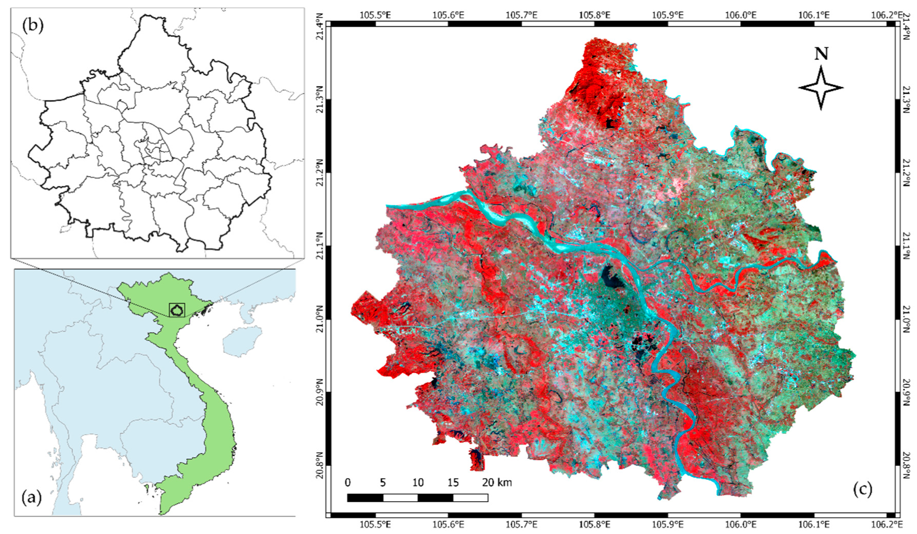
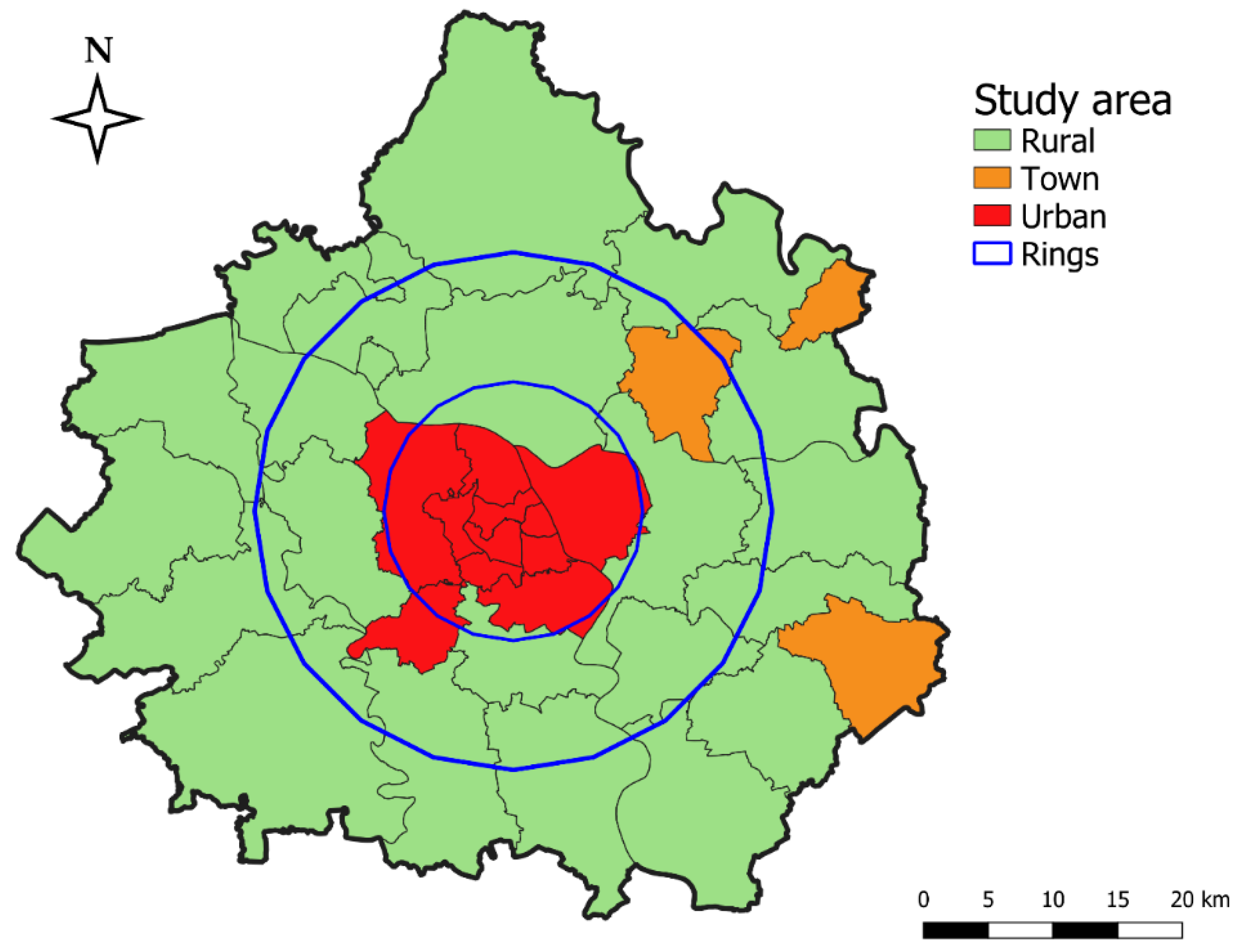
2.1. Study Area: Hanoi and Its Surrounding
2.2. Data Sources
2.3. Data Processing
2.4. Urban Expansion Dynamics
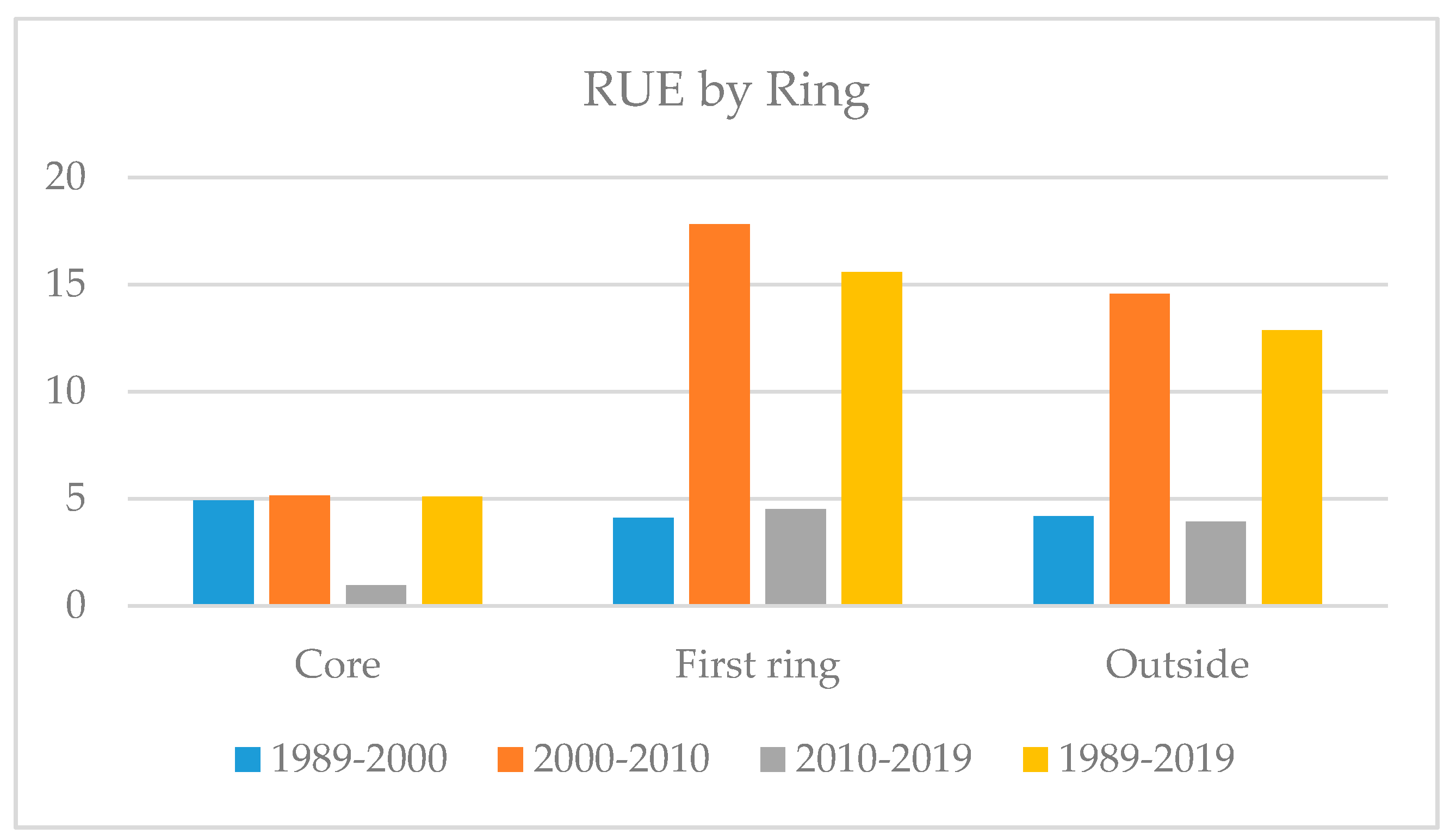
2.4.1. The Rate of Urban Expansion (RUE)
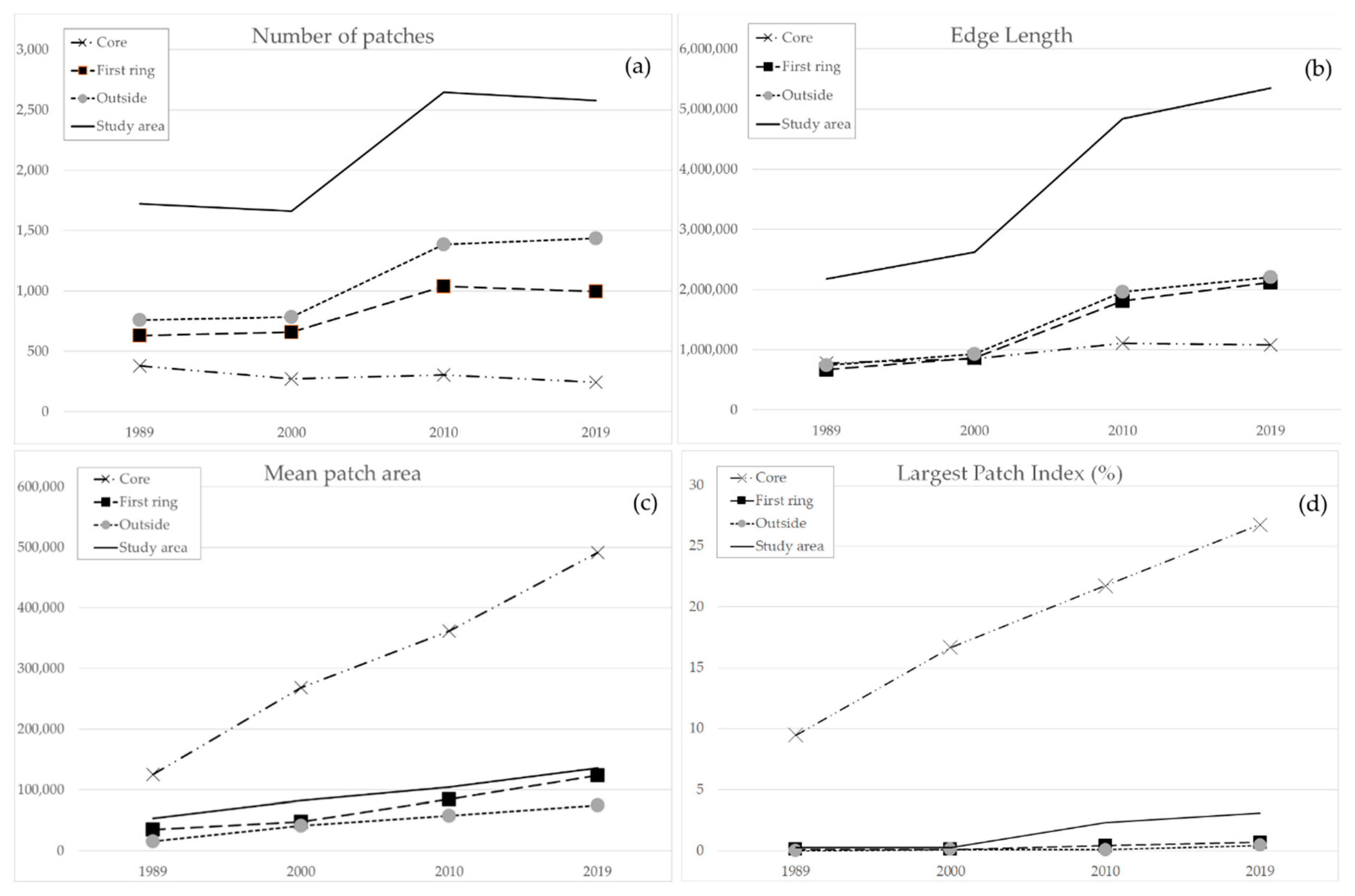
2.4.2. The Landscape Metrics
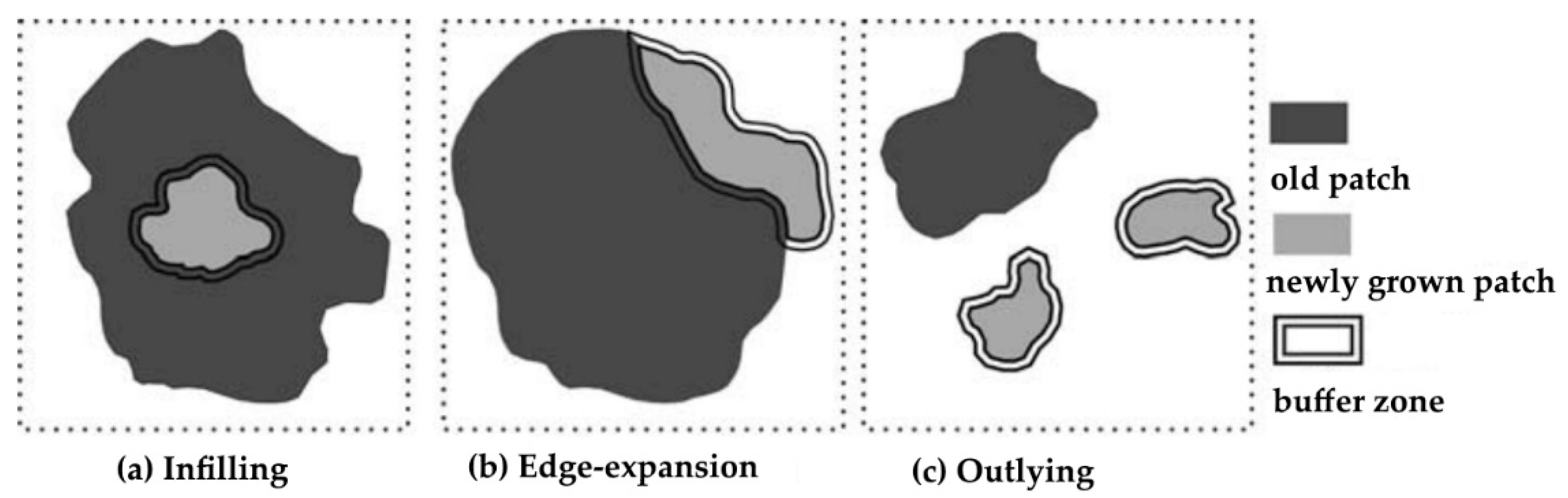
2.4.3. The Landscape Expansion Index (LEI)
3. Results and Discussion
3.1. Accuracy Assessment
3.2. The Classified Images: Some Significant Statistics
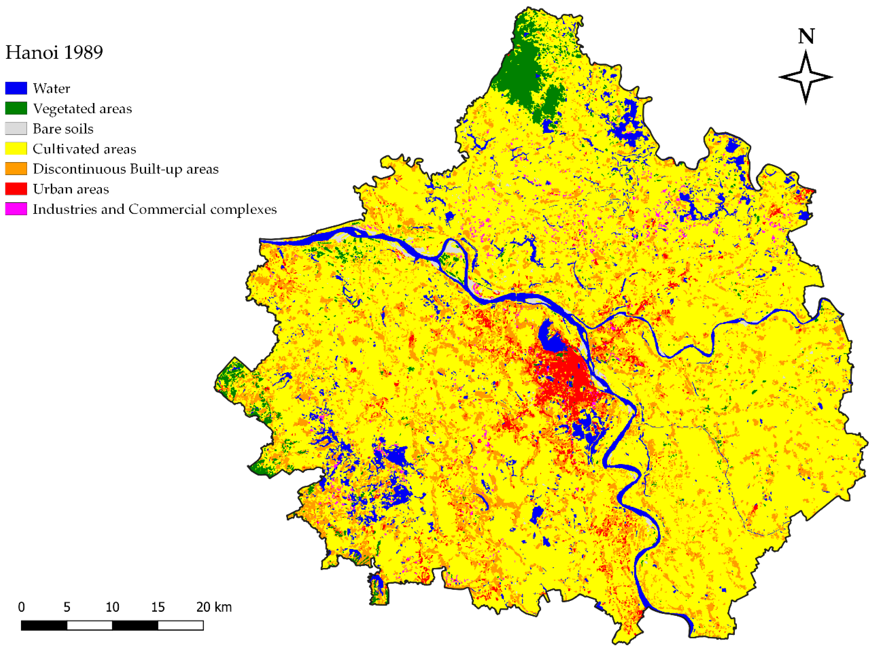
3.2.1. The LULC in 1989
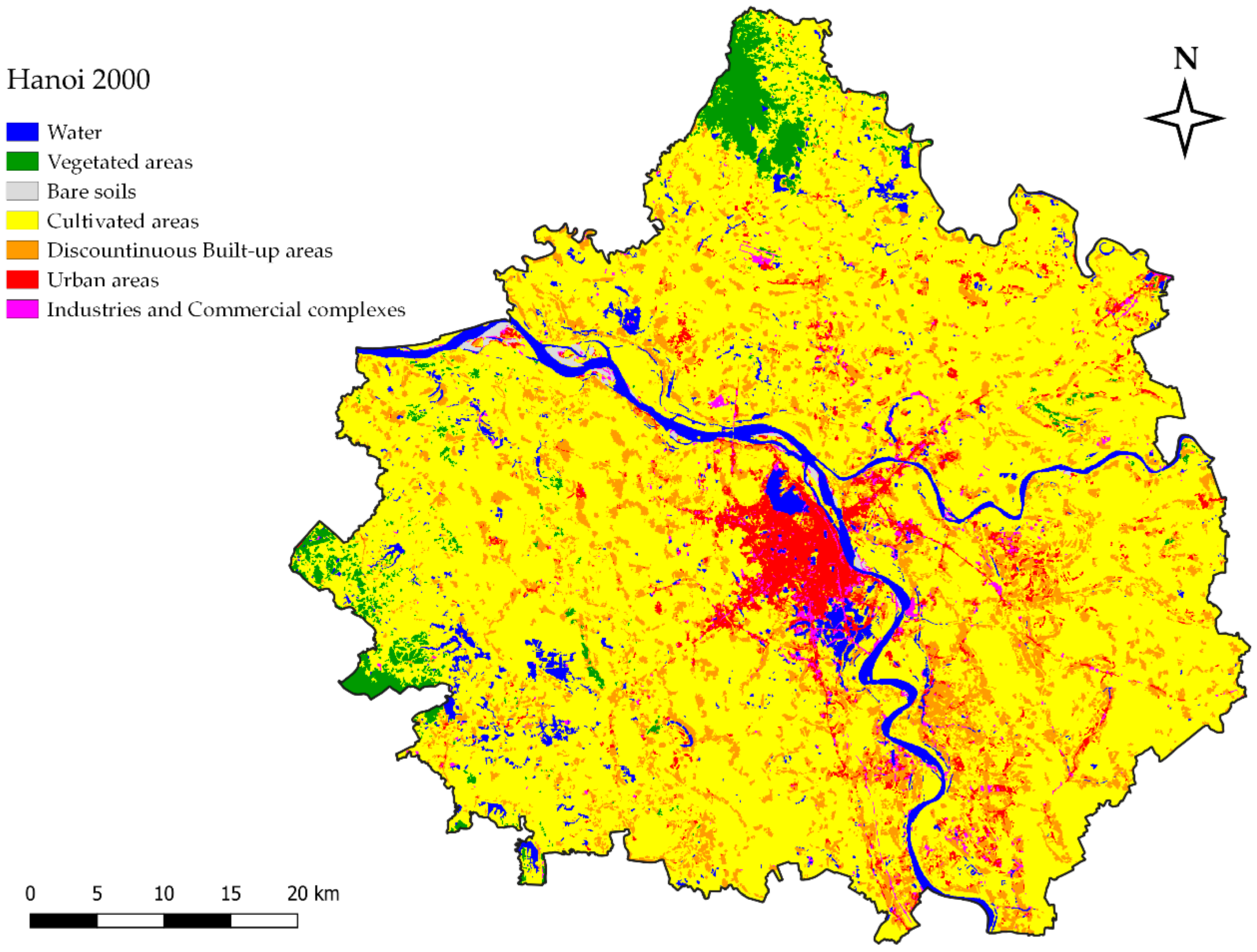
3.2.2. The LULC in 2000
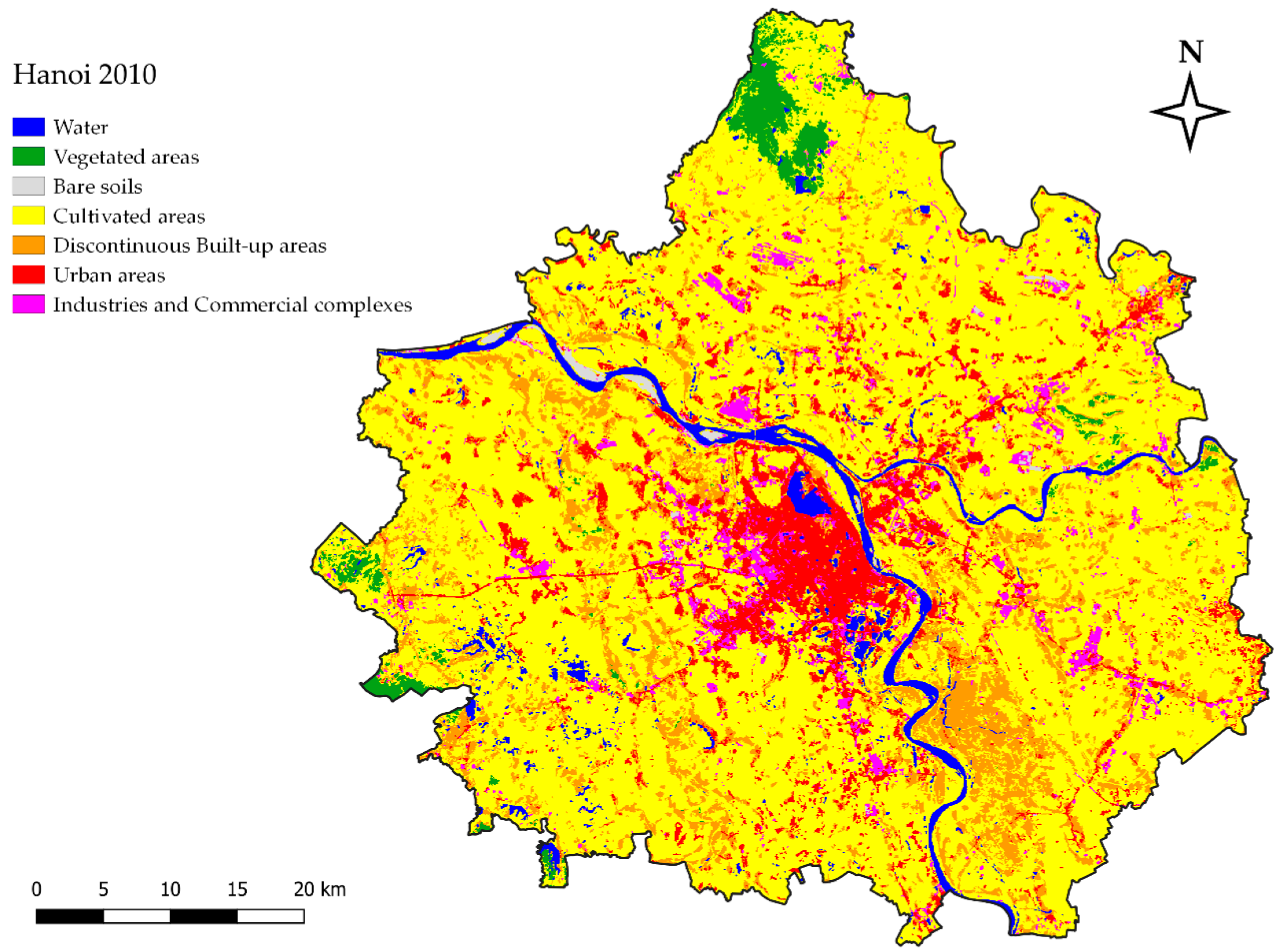
3.2.3. The LULC in 2010
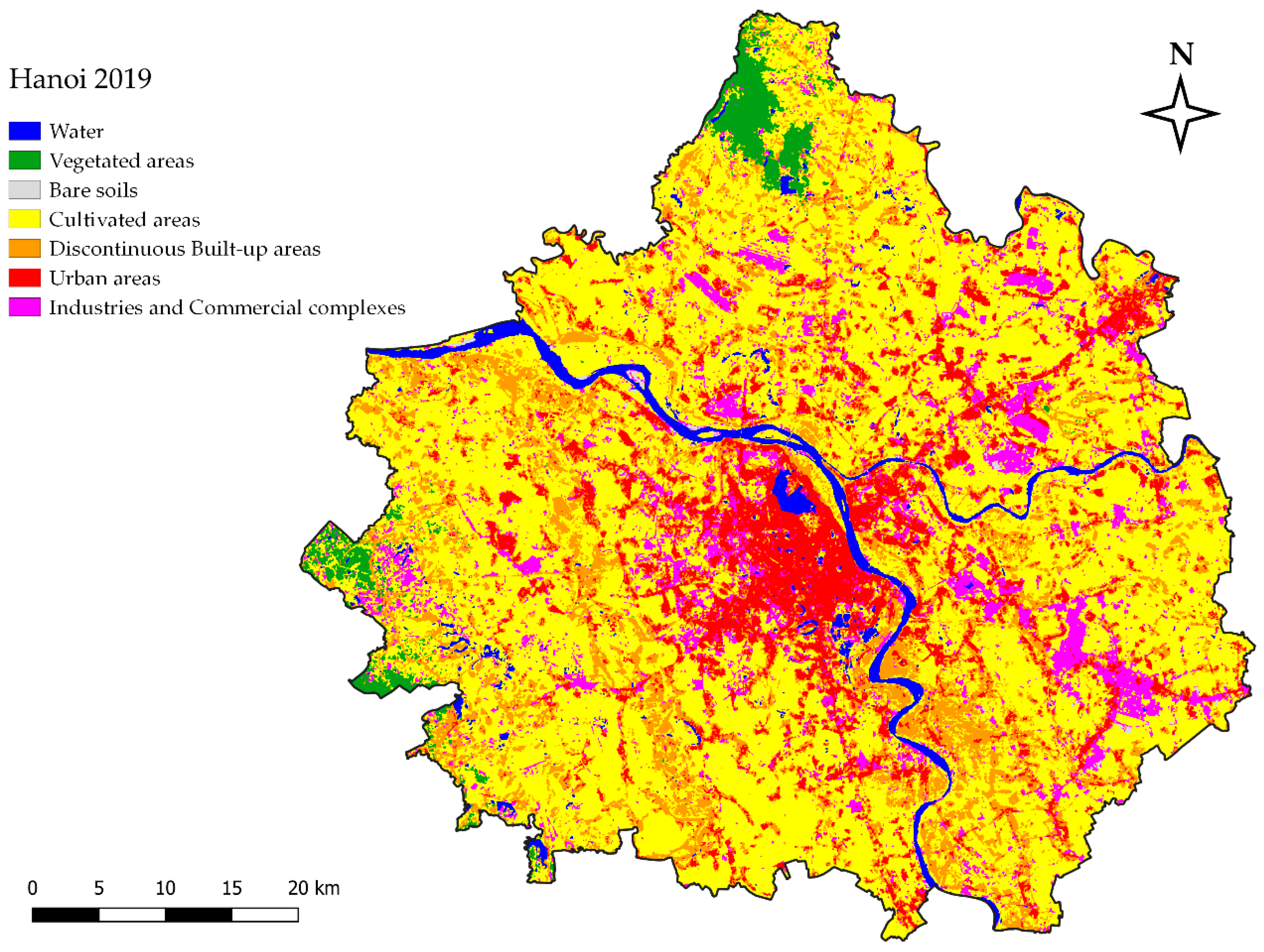
3.2.4. The LULC in 2019
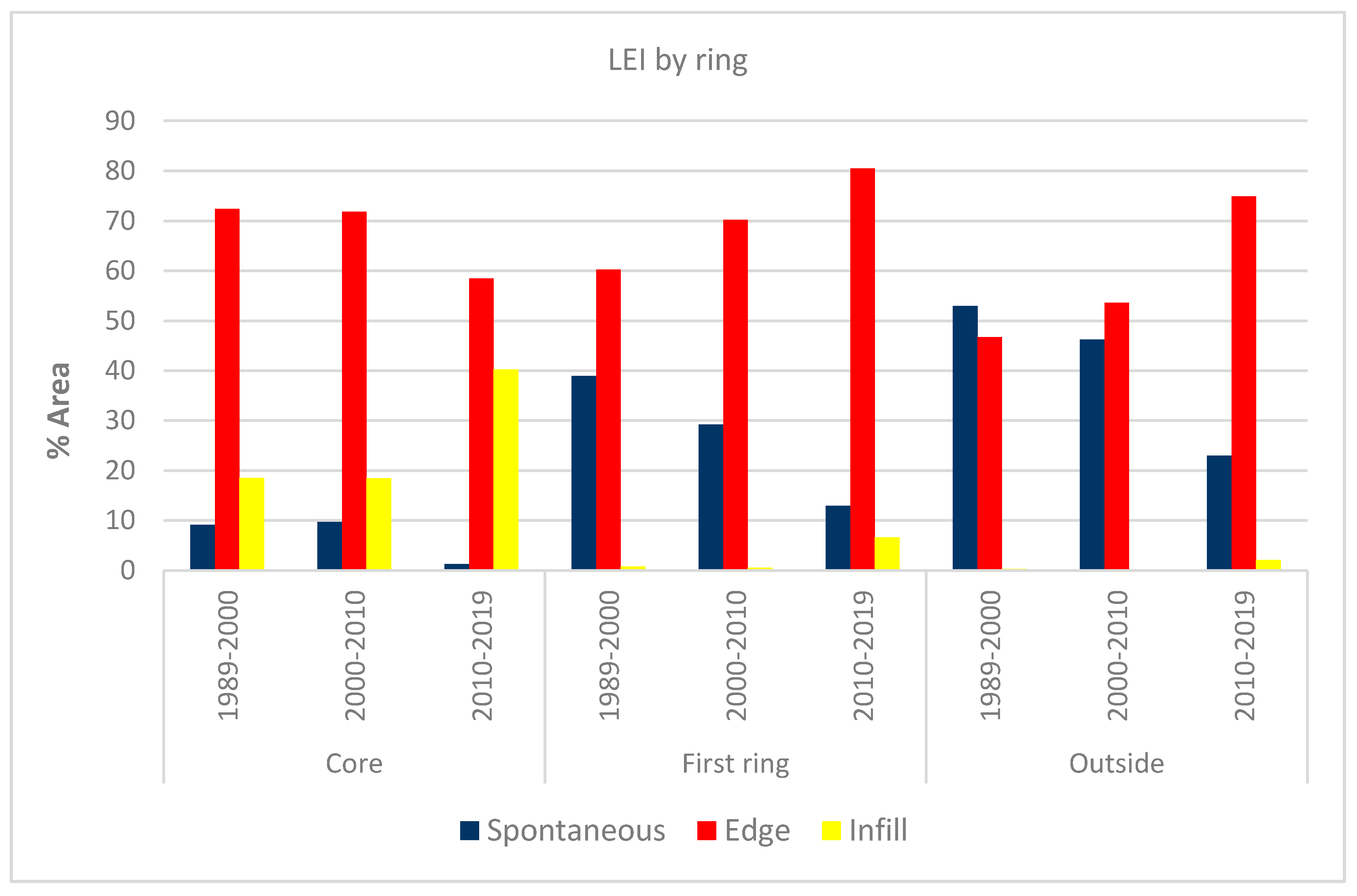
3.3. Delineating the Dynamics of Urban Expansion
4. Conclusions
Funding
Conflicts of Interest
References
- United Nations, Department of Economic and Social Affairs. World Urbanization Prospects: The 2018 Revision; United Nations: New York, NY, USA, 2019; pp. 1–2. [Google Scholar]
- United Nations, Department of Economic and Social Affairs, Population Division. World Urbanization Prospects: The 2014 Revision; United Nations: New York, NY, USA, 2014; p. 2. [Google Scholar]
- United Nations, Department of Economic and Social Affairs. World Urbanization Prospects: Highlights; United Nations: New York, NY, USA, 2019; pp. 29–30. [Google Scholar]
- Schneider, A.; Mertes, C.M.; Tatem, A.J.; Tan, B.; Sulla-Menashe, D.; Graves, S.J.; Patel, N.N.; Horton, J.A.; Gaugan, A.E.; Rollo, J.T.; et al. A new urban landscape in East-Southeast Asia, 2000–2010. Environ. Res. Lett. 2015, 10, 034002. [Google Scholar] [CrossRef]
- General Statistics Office (GSO). Statistical Yearbook of Vietnam 2019; Statistical Publishing House: Hanoi, Vietnam, 2020.
- Fan, P.; Ouyang, Z.; Nguyen, D.D.; Nguyen, T.T.H.; Park, H.; Chen, J. Urbanization, economic development, environmental and social changes in transitional economies: Vietnam after Doimoi. Landsc. Urban Plan. 2019, 187, 145–155. [Google Scholar] [CrossRef]
- Murray, P.; Szelenyi, I.; Martinet, F. L’anti-urbanisme des États socialistes. In Les Annales de la Recherche Urbaine; Ville et Etats; Centre de Recherche d’Urbanisme: Lyon, France, 1988; Volume 38, pp. 23–30. [Google Scholar] [CrossRef] [Green Version]
- Quertamp, F. La périurbanisation de Hanoi. Dinamiques de la transition urbaine vietnamienne et métropolisation. Ann. Géogr. 2010, 1, 93–119. [Google Scholar] [CrossRef]
- Quertamp, F.; de Miras, C. Periurbanization and governance of large metropolises in Vietnam. In Trends of Urbanization and Suburbanization in Southeast Asia; Tran, T.N.Q., Quertamp, F., Miras, C., Nguyen, Q.V., Le, V.N., Truong, H.T., Eds.; Ho Chi Minh City General Publishing House: Ho Chi Minh City, Vietnam, 2012; pp. 75–92. [Google Scholar]
- Labbé, D. Facing the Urban Transition in Hanoi: Recent Urban Planning and Initiatives; Institut National de la Recherche Scientific (INRS), Centre Urbanisation, Culture et Société: Quebec, QC, Canada, 2010; pp. 13–17, 21–27, 33–41. [Google Scholar]
- Sohr, A.; Brockfeld, E.; Sauerländer, A.; Melde, E. Traffic Information System for Hanoi. Procedia Eng. 2016, 142, 220–227. [Google Scholar] [CrossRef] [Green Version]
- Logan, W.S. Heritage planning in post Doi Moi Hanoi: The national and international contributions. J. Am. Plan. Assoc. (JAPA) 1995, 61, 328–343. [Google Scholar] [CrossRef]
- Logan, W.S. Hanoi, Vietnam. Representing power in and of the nation. City 2009, 13, 87–94. [Google Scholar] [CrossRef] [Green Version]
- Leducq, D.; Scarwell, H.-J. The new Hanoi: Opportunities and challenges for future urban development. Cities 2018, 62, 70–81. [Google Scholar] [CrossRef]
- McGee, T.G. The emergence of desakota regions in Asia: Expanding a hypothesis. In The Extended Metropolis. Settlement Transition in Asia; Ginsburg, N.J., Koppel, B., McGee, T.G., Eds.; University of Hawaii Press: Honolulu, HI, USA, 1991; pp. 3–26. [Google Scholar]
- Labbé, D.; Musil, C. Periurban Land Redevelopment in Vietnam under Market Socialism. Urban Stud. 2014, 51, 1146–1161. [Google Scholar] [CrossRef]
- Friedmann, J. Becoming urban: Periurban dynamics in Vietnam and China. Pac. Aff. 2011, 84, 425–434. [Google Scholar] [CrossRef]
- Friedmann, J. The future of periurban research. Cities 2016, 53, 163–165. [Google Scholar] [CrossRef]
- Wolman, A. The metabolism of cities. Sci. Am. 1965, 213, 179–190. [Google Scholar] [CrossRef] [PubMed]
- Kennedy, C.; Cuddihy, J.; Engel-yan, J. The changing metabolism of cities. J. Ind. Ecol. 2007, 11, 43–59. [Google Scholar] [CrossRef]
- Brenner, N.; Katsikis, N. Operational landscapes: Hinterlands of the Capitalocene. Archit. Des. 2020, 90, 22–31. [Google Scholar] [CrossRef]
- Brenner, N. The hinterland urbanised? Archit. Des. 2016, 86, 118–127. [Google Scholar] [CrossRef]
- Woodcock, C.E.; Allen, R.; Anderson, M.; Belward, A.; Bindschadler, R.; Cohen, W.B.; Gao, F.; Goward, S.N.; Helder, D.; Helmer, E.; et al. Free access to Landsat imagery. Science 2008, 320, 1011. [Google Scholar] [CrossRef]
- Wulder, M.A.; Masek, J.G.; Cohen, W.B.; Loveland, T.R.; Woodcock, C.E. Opening the archive: How free data has enabled the science and monitoring promise of Landsat. Remote Sens. Environ. 2012, 122, 2–10. [Google Scholar] [CrossRef]
- Mauro, G. Dinamiche Urbane e Città Post-Socialiste: Monitoraggio Mediante Telerilevamento. Casi di Studio; EUT (Edizioni Università di Trieste): Trieste, Italy, 2016; pp. 83–120. Available online: http://hdl.handle.net/10077/12841 (accessed on 23 September 2020).
- Saksena, S.; Fox, J.; Spencer, J.; Castrence, M.; DiGregorio, M.; Epprecht, M.; Sultana, N.; Finucane, M.; Nguyen, L.; Vien, T. Classifying and mapping the urban transition in Vietnam. Appl. Geogr. 2014, 50, 80–89. [Google Scholar] [CrossRef]
- Castrence, M.; Nong, D.H.; Tran, C.C.; Young, L.; Fox, J. Mapping urban transitions using multi-temporal Landsat and DMSP-OLS night-time lights imagery of the Red River Delta in Vietnam. Land 2014, 3, 148–166. [Google Scholar] [CrossRef] [Green Version]
- Tu, D.V.A.; Karlamova, N.V.; Ionkina, E.S.; Ha, N.T.T. Study changes in the River Red section flowing though Hanoi area using Landsat satellite images. EasyChair 2020, 3776, 2–12. Available online: https://easychair.org/publications/preprint/2npj (accessed on 23 September 2020).
- Nguyen, T.M.; Lin, T.-H.; Chan, H.-P. The environmental effects of urban development in Hanoi. Vietnam from satellite and meteorological observations from 1999–2016. Sustainability 2019, 11, 1768. [Google Scholar] [CrossRef] [Green Version]
- Nguyen, T.T. Landsat time-series images-based urban heat island analysis: The effects on change in vegetation and built-up land on surface temperature in summer in the Hanoi metropolitan area, Vietnam. Environ. Nat. Res. J. 2020, 18, 177–190. [Google Scholar] [CrossRef]
- Ha, N.T.T.; Koike, K.; Nhuan, M.T.; Canh, B.D.; Thao, N.T.P.; Parson, M. Landsat 8/OLI two bands ratio algorithm for clorophyll-a concentration mapping in hypertrophic waters: An application to West Lake in Hanoi (Vietnam). IEEE J. Sel. Top. Appl. Earth Obs. Remote Sens. 2017, 10, 4919–4929. [Google Scholar] [CrossRef]
- Pham, H.M.; Yamaguchi, Y.; Bui, T.Q. A case study on the relation between city planning and urban growth using remote sensing and spatial metrics. Landsc. Urban Plan. 2011, 100, 223–230. [Google Scholar] [CrossRef]
- Viet, P.B.; Duan, H.D.; Raghavan, V.; Shibayama, M. Using satellite imagery to study spatial urban expansion of Hanoi city. In Proceedings of the International Symposium of Geoinformatics for Spatial Infrastructure Development in Earth and Allied Sciences (GIS-IDEAS), Ho Chi Minh, Vietnam, 9–11 November 2006. [Google Scholar]
- Duan, H.D.; Shibayama, M. Studies on Hanoi urban transition in the late 20th century based on GIS/RS. Southeast Asian Stud. 2009, 46, 532–546. [Google Scholar]
- Hai, P.M.; Yamaguchi, Y. Characterizing the urban growth from 1975 to 2003 of Hanoi city using remote sensing and a spatial metric. Forum Geogr. 2007, 21, 104–110. [Google Scholar] [CrossRef] [Green Version]
- Nong, D.H.; Fox, J.; Miura, T.; Saksena, S. Built-up area change analysis in Hanoi using support vector machine classification of Landsat multi-temporal image stacks and population data. Land 2015, 4, 1213–1231. [Google Scholar] [CrossRef] [Green Version]
- Nong, D.H.; Lepczyk, C.A.; Miura, T.; Fox, J.M. Quantifying urban growth patterns in Hanoi using landscape expansion modes and time series spatial metrics. PLoS ONE 2018, 13, e0196940. [Google Scholar] [CrossRef] [Green Version]
- Robinson, A.H.; Morrison, J.L.; Muehrcke, P.C.; Kimerling, A.J.; Guptil, S.C. Elements of Cartography; Wiley: New York, NY, USA, 1995; pp. 92–94. [Google Scholar]
- van Horen, B. Hanoi. Cities 2005, 22, 161–173. [Google Scholar] [CrossRef]
- van den Berg, L.M.; van Wijk, M.S.; Van Hoi, P. The transformation of agriculture and rural life downstream of Hanoi. Environ. Urban. 2003, 15, 961–974. [Google Scholar] [CrossRef]
- Pham, V.C.; Pham, T.-T.-H.; Tong, T.H.A.; Nguyen, T.T.H.; Pham, N.H. The conversion of agricultural land in the peri-urban areas of Hanoi (Vietnam): Patterns in space and time. J. Land. Use. Sci. 2015, 10, 224–242. [Google Scholar] [CrossRef]
- Congalton, R.G.; Green, K. Assessing the Accuracy of Remotely Sensed Data: Principles and Practices; CRC Press: Boca Raton, FL, USA, 2008. [Google Scholar]
- Li, X.; Zhang, L.; Liang, C. A GIS-based buffer gradient analysis on spatiotemporal dynamics of urban expansion in Shanghai and its major satellite cities. Procedia Environ. Sci. 2010, 2, 1139–1156. [Google Scholar] [CrossRef] [Green Version]
- Fenta, A.A.; Yasuda, H.; Haregeweyn, N.; Belay, A.S.; Hadush, Z.; Gebremedhin, M.A.; Mekonnen, G. The dynamics of urban expansion and land use/land cover using remote sensing and spatial metrics: The case of Mekelle City of northern Ethiopia. Int. J. Remote Sens. 2017, 38, 4107–4129. [Google Scholar] [CrossRef]
- Jung, M. LecoS—A python plugin for automated landscape ecology analysis. Ecol. Inform. 2016, 31, 18–21. [Google Scholar] [CrossRef]
- McGarigal, K.; Marks, B. FRAGSTATS: Spatial Pattern Analysis Program for Quantifying Landscape Structure; USDA Forest Service, Pacific Northwest Research Station: Portland, OR, USA, 1995. [CrossRef]
- Xiaoping, L.; Xia, L.; Yimin, C.; Zhangzhi, T.; Shaoying, L.; Bin, A. A new landscape index for quantifying urban expansion using multi-temporal remotely sensed data. Landsc. Ecol. 2010, 25, 671–682. [Google Scholar] [CrossRef]
- Colganton, R.G. Accuracy assessment and validation or remotely sensed and other spatial information. Int. J. Wildland Fire 2001, 10, 321–328. [Google Scholar] [CrossRef] [Green Version]
- Morales-Barquero, L.; Lyons, M.B.; Phinn, S.R.; Roelfsema, C.M. Trends in remote sensing accuracy assessment. Approaches in the context of natural resources. Remote Sens. 2019, 11, 2305. [Google Scholar] [CrossRef] [Green Version]
- Quang, N.; Kammeier, H.D. Changes in the political economy of Vietnam and their impacts on the built environment of Hanoi. Cities 2002, 19, 373–388. [Google Scholar] [CrossRef]
- Dao, T.N.; Nguyen, Q.T. Gentrifications in Hanoi city inner: Characteristics, causes and solutions. IJST Technol. Civ. Eng. 2018, 12, 89–101. [Google Scholar] [CrossRef] [Green Version]
- Labbé, D. Land Politics and Livelihoods on the Margins of Hanoi, 1920–2010; UBC Press: Vancouver, BC, Canada, 2014; p. 4. [Google Scholar]
- World Bank. Vietnam Urbanization Review: Technical Assistance Report. World Bank. 2011, pp. 119–121. Available online: https://openknowledge.worldbank.org/handle/10986/2826 (accessed on 23 September 2020).
- Tran, H.A. Urban Space Production in Transition: The Cases of the New Urban Areas of Hanoi. Urban Policy Res. 2015, 33, 79–97. [Google Scholar] [CrossRef]
- Fanchette, S. Periurban Craft Villages in the Storm of Hanoi Expansion. In Trends of Urbanization and Suburbanization in Southeast Asia; Ton, N.Q.T., Quertamp, F., Miras, C.D., Nguyen, Q.V., Le, V.N., Truong, H.T., Eds.; Center for Urban and Development Studies (CEFURDS), Ho Chi Minh City General Publishing House: Ho Chi Minh City, Vietnam, 2008; pp. 227–252. [Google Scholar]
- Sakata, S. Rural industries in the northern Vietnam: Strategies of small-scale business establishments in the formation of craft villages. In Vietnam’s Economic Entities in Transition; Sakata, S., Ed.; IDE-JETRO Series; Palgrave Macmillan: London, UK, 2013; pp. 204–226. [Google Scholar] [CrossRef]
- Monte-Mór, R.L.; Castriota, R. Extended Urbanization: Implications for urban and regional theory. In Handbook on the Geographies of Regions and Territories; Paasi, A., Harrison, J., Jones, M., Eds.; Edgard Elgar: Cheltenham, Northampton, UK, 2018; pp. 332–345. [Google Scholar] [CrossRef]
- Nguyen, T.L. Environmental pollution in Vietnam’s craft villages. E3S Web Conf. 2020, 175, 06012. [Google Scholar] [CrossRef]
- Nguyen, H.L.; Duan, J.; Liu, J.H. State control versus hybrid land markets: Planning and urban development in transitional Hanoi, Vietnam. Sustainability 2018, 10, 2993. [Google Scholar] [CrossRef] [Green Version]


| Satellite | Sensor | Date of Acquisition | WRS -Path | WRS-Row | Cloud Coverage (%) |
|---|---|---|---|---|---|
| Landsat 5 | Thematic Mapper (TM) | 1989-11-30 | 127 | 045; 046 | 4; 8 |
| Landsat 7 | Enhanced Thematic Mapper (ETM+) | 2000-11-04 | 127 | 045; 046 | 0; 1 |
| Landsat 5 | Thematic Mapper (TM) | 2010-11-08 | 127 | 045; 046 | 1; 1 |
| Landsat 8 | Operational Land Imager sensor/Thermal Infrared Sensor (OLI/TIRS) | 2019-09-30 | 127 | 045; 046 | 0; 1 |
| Landscape Metrics | Description | Diffusion | Coalescence |
|---|---|---|---|
| Number of patches (NP) | Total number of patches in landscape | Increasing | Decreasing |
| Edge length (EL) | Sum of the lengths (m) of all edge segments in landscape | Increasing | Decreasing |
| Mean patch area (MPA) | Average area of patches (in sq. m) | Decreasing | Increasing |
| Largest patch index (LPI) | Proportion (%) of landscape covered by largest patch | Decreasing | Increasing |
| Year | Overall Accuracy | K Value |
|---|---|---|
| 1989 | 86% | 0.813 |
| 2000 | 84% | 0.779 |
| 2010 | 85% | 0.800 |
| 2019 | 88% | 0.846 |
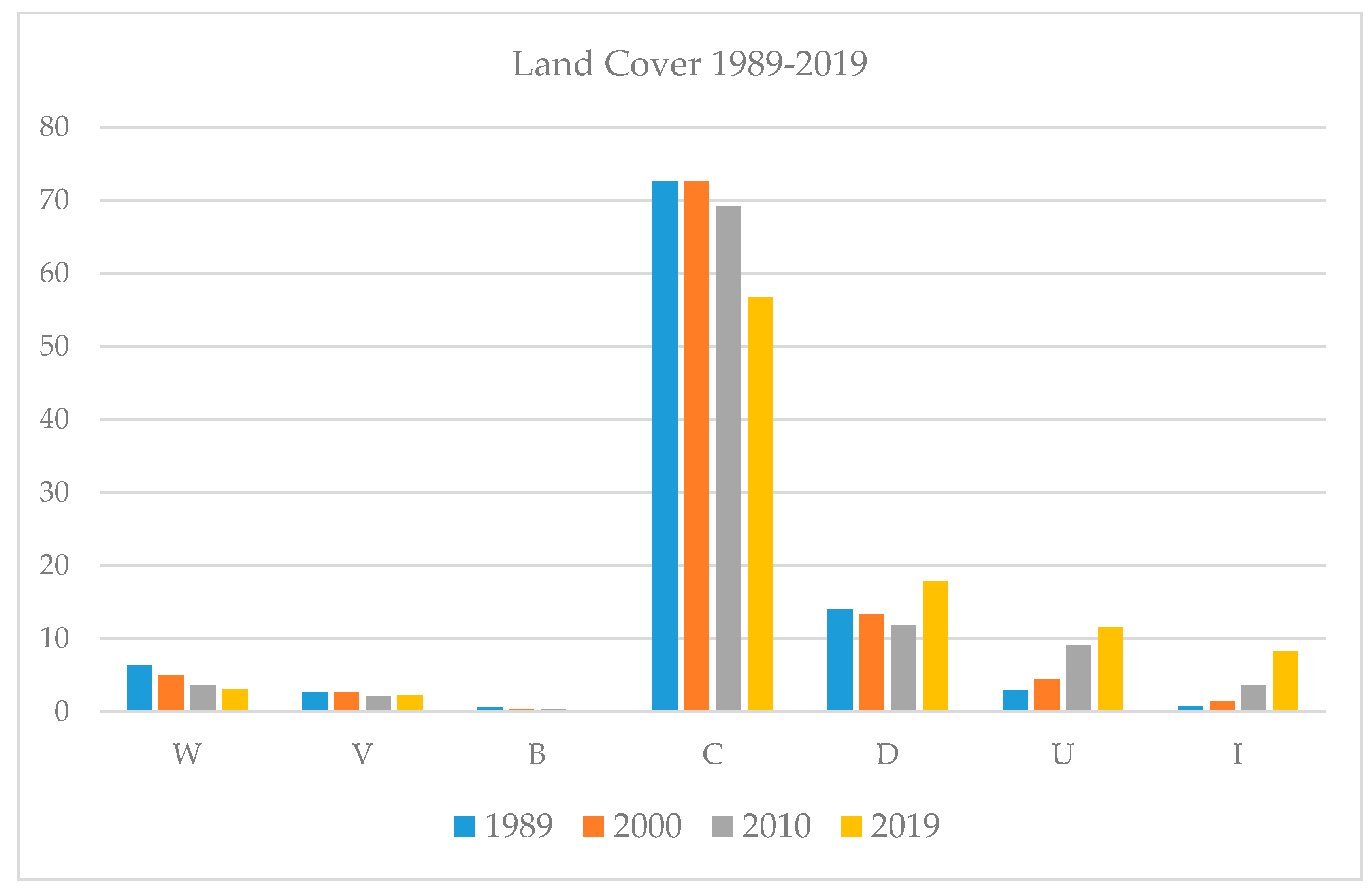
| Land Cover | 1989 | 2000 | 2010 | 2019 | ||||
|---|---|---|---|---|---|---|---|---|
| km2 | % | km2 | % | km2 | % | km2 | % | |
| W | 193.9 | 6.4 | 153.7 | 5 | 110.2 | 3.6 | 95.9 | 3.1 |
| V | 79.7 | 2.6 | 83.3 | 2.7 | 63.3 | 2.1 | 68.2 | 2.2 |
| B | 17.6 | 0.6 | 8.6 | 0.3 | 13 | 0.4 | 7.1 | 0.2 |
| C | 2217.1 | 72.7 | 2214.9 | 72.6 | 2112.5 | 69.3 | 1731.9 | 56.8 |
| D | 427.4 | 14 | 407.9 | 13.4 | 363.4 | 11.9 | 542.6 | 17.8 |
| U | 91.1 | 3 | 136.7 | 4.5 | 277.4 | 9.1 | 351.1 | 11.5 |
| I | 23.2 | 0.8 | 44.9 | 1.5 | 110.3 | 3.6 | 253.3 | 8.3 |
| Total | 3050.1 | 100 | 3050.1 | 100 | 3050.1 | 100 | 3050.1 | 100 |
| Land Cover | 2000–1989 | 2010–2000 | 2019–2010 | 2019–1989 |
|---|---|---|---|---|
| W | −1.4 | −1.4 | −0.5 | −3.3 |
| V | 0.1 | −0.6 | 0.1 | −0.4 |
| B | −0.3 | 0.1 | −0.2 | −0.4 |
| C | −0.1 | −3.3 | −12.5 | −15.9 |
| D | −0.6 | −1.5 | 5.9 | 3.8 |
| U | 1.5 | 4.6 | 2.4 | 8.5 |
| I | 0.7 | 2.1 | 4.7 | 7.5 |
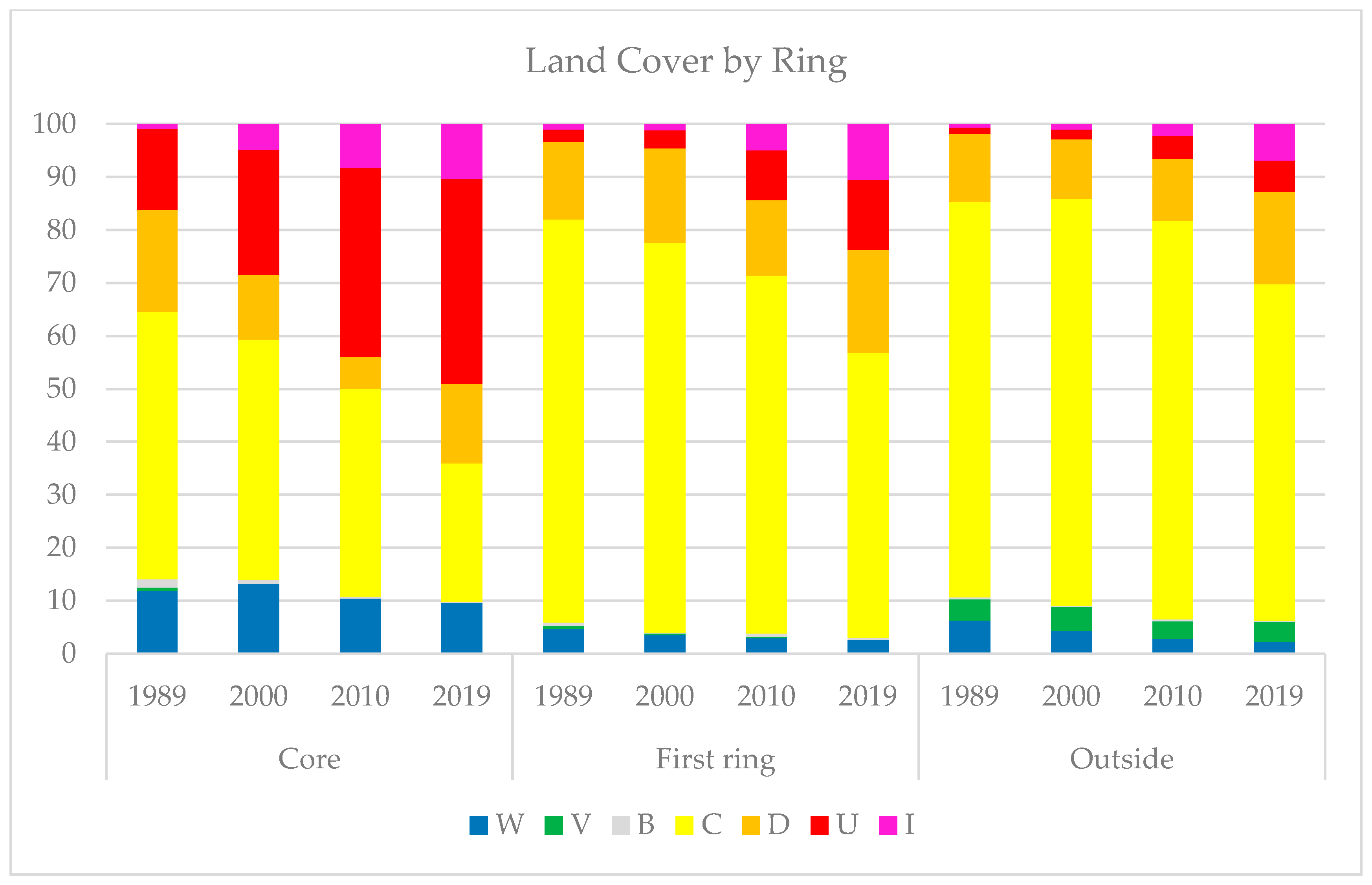
| Year | W | V | B | C | D | U | I | |
|---|---|---|---|---|---|---|---|---|
| Core | 1989 | 11.9 | 0.7 | 1.5 | 50.5 | 19.3 | 15.3 | 0.9 |
| 2000 | 13.3 | 0 | 0.7 | 45.4 | 12.2 | 23.6 | 4.9 | |
| 2010 | 10.4 | 0 | 0.4 | 39.3 | 6.0 | 35.7 | 8.2 | |
| 2019 | 9.6 | 0 | 0.1 | 26.2 | 14.9 | 38.8 | 10.3 | |
| First ring | 1989 | 4.6 | 0.6 | 0.7 | 76.1 | 14.7 | 2.3 | 1.0 |
| 2000 | 3.6 | 0.2 | 0.1 | 73.6 | 17.9 | 3.4 | 1.2 | |
| 2010 | 2.9 | 0.3 | 0.6 | 67.5 | 14.3 | 9.4 | 4.9 | |
| 2019 | 2.6 | 0 | 0.4 | 53.8 | 19.4 | 13.3 | 10.5 | |
| Outside | 1989 | 6.3 | 4.0 | 0.4 | 74.7 | 12.8 | 1.2 | 0.6 |
| 2000 | 4.4 | 4.5 | 0.3 | 76.7 | 11.3 | 1.8 | 1.1 | |
| 2010 | 2.8 | 3.4 | 0.3 | 75.3 | 11.7 | 4.4 | 2.2 | |
| 2019 | 2.3 | 3.7 | 0.2 | 63.5 | 17.5 | 5.9 | 6.8 |
| Urban Area | Rate of Urban Expansion (% Year−1) | ||||
|---|---|---|---|---|---|
| Year | km2 | 1989–2000 | 2000–2010 | 2010–2019 | 1989–2019 |
| 1989 | 91.1 | 4.5 | |||
| 2000 | 136.7 | 10.3 | |||
| 2010 | 277.4 | 2.9 | |||
| 2019 | 351.1 | 9.5 | |||
| Change (km2 year−1) | 4.1 | 14.1 | 8.2 | 8.7 | |
| Patches | Type | 1989–2000 | 2000–2010 | 2010–2019 |
|---|---|---|---|---|
| Number (%) | Infill | 9.5 | 11.3 | 18.5 |
| Edge expansion | 58.4 | 60 | 67.9 | |
| Spontaneous | 32.1 | 28.7 | 13.6 | |
| Area (%) | Infill | 6.9 | 4.8 | 10.7 |
| Edge expansion | 59.4 | 62.9 | 73.6 | |
| Spontaneous | 33.7 | 32.3 | 15.7 |
Publisher’s Note: MDPI stays neutral with regard to jurisdictional claims in published maps and institutional affiliations. |
© 2020 by the author. Licensee MDPI, Basel, Switzerland. This article is an open access article distributed under the terms and conditions of the Creative Commons Attribution (CC BY) license (http://creativecommons.org/licenses/by/4.0/).
Share and Cite
Mauro, G. Rural–Urban Transition of Hanoi (Vietnam): Using Landsat Imagery to Map Its Recent Peri-Urbanization. ISPRS Int. J. Geo-Inf. 2020, 9, 669. https://doi.org/10.3390/ijgi9110669
Mauro G. Rural–Urban Transition of Hanoi (Vietnam): Using Landsat Imagery to Map Its Recent Peri-Urbanization. ISPRS International Journal of Geo-Information. 2020; 9(11):669. https://doi.org/10.3390/ijgi9110669
Chicago/Turabian StyleMauro, Giovanni. 2020. "Rural–Urban Transition of Hanoi (Vietnam): Using Landsat Imagery to Map Its Recent Peri-Urbanization" ISPRS International Journal of Geo-Information 9, no. 11: 669. https://doi.org/10.3390/ijgi9110669
APA StyleMauro, G. (2020). Rural–Urban Transition of Hanoi (Vietnam): Using Landsat Imagery to Map Its Recent Peri-Urbanization. ISPRS International Journal of Geo-Information, 9(11), 669. https://doi.org/10.3390/ijgi9110669