Article

Evidence of Climate Change and the Conservation Needed to Halt the Further Deterioration of Small Glacial Lakes

1
Faculty of Biotechnology and Food, Agricultural University of Tirana, Rruga Paisi Vodica, 1025 Tirana, Albania
2
Faculty of Applied Sciences and Creative Industries, Barleti University, 1022 Tirana, Albania
3
Faculty of Science, University of Zagreb, Horvatovac 102a, 10000 Zagreb, Croatia
4
Faculty of Natural Sciences, Tirana University, Bulevardi Zogu I 25, 1002 Tirana, Albania
*
Author to whom correspondence should be addressed.
Climate 2024, 12(8), 124; https://doi.org/10.3390/cli12080124
Submission received: 2 July 2024 / Revised: 30 July 2024 / Accepted: 13 August 2024 / Published: 19 August 2024

Abstract

:
Although somewhat debated, it is generally agreed in Europe that small water bodies comprise lentic ecosystems that are shallow (less than 20 m) and have a surface area of a few hectares (less than 10 ha). In Albania, 84 glacial lakes constitute a substantial portion of the aquatic ecosystems that sustain high levels of biodiversity, metabolic rates, and functionality. This paper discusses the integration of ecological sustainability into ecosystem services (i.e., cultural, regulatory, and sustaining services) and the national ecological networks of protected sites. This integration is particularly important in light of recent advancements regarding European integration. It is also important due to the catchment continuum, which addresses biodiversity values and gradients that, in this work, are considered using rotifer communities and aquatic plant species. The main causes of the stressors on small ecosystems are inappropriate land use, water pollution, altered habitats, non-native species introduction, resource mismanagement in basins, inadequate planning, and a lack of sector integration. The glacial lakes reflect climate change elements through: an increased number of dried glacial lakes, so only 84 remain functioning; the water level is slowly being reduced; the oscillation of the water level is steadily increasing; and the eutrophication process is rapidly advancing.

1. Introduction

Significant climate-driven changes are expected in the coming decades [1,2], with Mediterranean freshwater ecosystems being the most vulnerable areas [3,4]. Despite the attempts and objectives of international strategies to halt biodiversity decline [5,6], the task is increasingly challenging [7]; thus, scientific and technical management support is necessary. Located at very specific altitudes, glacial lake ecosystems are facing rapid changes due to the lack of snow cover and the rapid increase in temperature. The plant and animal biota of alpine regions are influenced by the amount, rates, and dynamics of snow cover [8,9], and the hydrological cycle of high-altitude basins is regulated by the availability of freshwater from the cryosphere in the spring and summer [10]. Thus, the rapid deglaciation of the European Alps is one of the main indicators of shifting geomorphic processes and global warming [11,12]. Since the end of the Little Ice Age (LIA), the area covered by glaciers has declined by more than 50% [12,13]. Several ecosystems in Albania attest to this phenomenon, and new landscapes have emerged where there once was a water-covered area. To analyze the state, connectivity, climate-change-driven impacts, and bias with conservation approaches covering mountain environments, detailed data on lakes’ evolution, spatial distribution, and characteristics are required. In order to contribute to the regional picture of glacial lake distribution, we consequently created an inventory of glacial lakes for the Albanian upland areas (over 1450 m above sea level). With the help of publicly accessible high-resolution picture data, the lakes were manually mapped. Furthermore, we followed the current network of conservation designations, where a considerable number of lakes are an integral part of the protection. The original designation was based on the geological and biodiversity values of both terrestrial ecosystems. The glacial chronology and glaciations found in the mountains of Albania are related to those found in the Mediterranean and Dinaric arc regions, where the phenomena are thought to be related to certain known glaciations that occurred in the Late Pleistocene [14,15,16,17]. Furthermore, although there are different interpretations, it is hypothesized that in the Albanian Alps (and the rest of the mountains where the glacial lakes are situated), the glaciations took place in the Early or Middle Pleistocene (0.781–0.126 million years ago) [17].
Freshwater biotic communities are important components of lake functioning. In addition to the altitudes and origins of glacial bodies, vegetation and fauna groups are of high interest and among the least studied. One of the most significant components is zooplankton, composed of invertebrates from several taxonomic categories, the principal ones being copepods, cladocerans, and rotifers. Zooplankton serves as a vital component of the food web and plays a role in the self-purification processes of aquatic ecosystems, as it is consumed by fish and other invertebrates [18,19,20]. Additionally, aquatic plants are also good indicators of the ecological state and eutrophication process [21]. They are directly linked to the biotic integrity of aquatic ecosystems [22] and are hence incorporated in the monitoring of surface water by the Water Framework Directive [23]. Presently, there are records of deterioration in the water quality of both running and standing water bodies [24].
The study area includes all of the country. A literature search for high-altitude aquatic habitats and, inparticular, glacier lakes was part of the data collection process. The dimensional limits of lentic water bodies (in our case glacial lakes) that were shallow (less than 20 m) and had a surface area of a few hectares (less than 10 hectares) allowed us to locate our target ecosystems and distinguish them from larger lentic aquatic ecosystems (including large- and middle-sized natural lakes of other-than-glacial origin and reservoirs established for different purposes, such as energy production, agriculture irrigation, or recreation).
The objectives of our study are: (1) to compile a list of the high alpine lakes in the uplands of Albania; (2) to investigate the lake characteristics and distribution and highlight the biodiversity values of selected animal and vegetation components; (3) to assess the snow-cover (cm) and low-temperature days (−0°C) and hypothesize the impacts caused by both climate change and anthropogenic interventions; and (4) to discuss the state of conservation and bias with protected areas designation in the Albanian Alps National Park, Korab–Koritnik Nature Park, Shebenik–Jabllanica National Park, etc.

2. Materials and Methods

Geographic coverage and lake surface data analyzed: The rivers of Albania are included in the 420 Southeast Adriatic Drainage on the worldwide ecoregion map [25,26]. To the best of our knowledge, the distribution and species composition of freshwater fish species serve as the basis for this map of freshwater ecoregions, which also includes important ecological and evolutionary features [27]. Albania is home to multiple major, currently autonomous, river and lake systems (Figure 1). They are listed here, from north to south: The rivers Mat (B), Ishëm (C), Erzen (D), Shkumbin (E), Seman (made up of two major inflows—Devoll and Osum) (F), and Vjosë (Aoos in Greece) (G) are part of the Ohrid–Drin–Skadar system (which includes the river Buna). Several other short rivers flow from the Cika mountain to the southernmost Adriatic Sea and the northernmost Ionian Sea (H), the area surrounding Butrint Lagoon (rivers Bistrica and Pavllo) (I). The majority of the lakes and rivers listed above (A–G) are located on the Adriatic slope, while the southernmost portion (I) is located on the Ionian Sea slope. Although the Prespa Lakes do not have a surface outflow of water, there are subterranean connections with Lake Ohrid [17]. The Danube basin includes only a very minor portion of the Albanian Alps in the country’s northernmost region [27]. All Albanian rivers have extremely varying seasonal discharges; in certain cases, summer discharges might be more than ten times lower than winter discharges. Since a lot of gravel and stones are deposited along the main rivers, their beds are typically very wide [27]. The topography of the region is very varied, with mountains in the east and flat plains in the west.
The approach followed for calculating the surfaces of glacial lakes and the lakes’ levels’ annual oscillations was based on commands used in the Google Earth Pro program. In this program, the base map is constantly updated, showing any changes in the topography over the years; in this particular case, the most recent images were used: October 2023. To measure a polygon (in this case, the glacial lakes) in this program, we used the following sequence of commands: In the toolbar, located at the top of the page, we selected “Show Ruler” and then clicked “Polygon”. After that, we outlined the surface in which we were interested within the base map. During this process, in the small table that we had displayed on the screen, the Perimeter and the Surface appeared, next to which, the unit of measurement was also given, which we could change as needed. Once the data, such as the area and perimeter, were obtained, we chose whether or not to save it as a polygon. To determine which lake surface we measured, the feature was saved by clicking “save”. Then, a new window opened, andwe were able to mark the name of the new polygon with the name of the corresponding lake. Finally, we clicked “Save” again. This whole process was repeated until all the planned surfaces were measured.
Further scenarios for future climate and connection to water bodies were used, and they camefrom two sources: the World Bank’s Climate Change Knowledge Portal (CCKP), which offers temperature and precipitation projections until 2100 for an ensemble of models, and Albania’s Third National Communication to the United Nations Convention to Combat Desertification (UNCCD).
Evaluation of management effectiveness and variable selection: Based on the Assessment of Management Plan Implementation, which was modified from Tool 9 of the Enhancing Our Heritage toolbox [28], surveys were carried out throughout the designated protected areas of Albania. More than 90% of the glacial lakes are found within the limits of these protected regions. The purpose of using this tool was to evaluate how well the protected area management plan was being implemented. The tool made it possible to evaluate the management plan’s implementation at both the overall and specific goal levels, including aquatic environments. We examined each plan action and assigned it a status category (such as “action has not commenced” or “action has been completed”). “Use of resources as lakes for recreational purposes”, “glacial lakes”, and “water ecosystem management” were also added.
The selected variables for the monitoring and assessment of the management capacities are presented in Table 1. These variables were classified into two groups and three levels according to their status and assumed importance. Group I included variables representing the foundation for a manager’s function: the existence of legal acts further stipulating acts to be adopted by the manager, as well as a manager’s human resource capacity. Group II contained variables representing the implementation of the legally prescribed obligations in the field.
Empirical analyses: The aggregate function S (scoring) was introduced, allocating to each observed protected area a numerical value from 0 to 100. The assessment model was built through a combination of the following variables: a1-1—if the protected area management plan existed; 0—otherwise; a2-1—if the professional staff consisted of at least three employees; 0—otherwise; a3-1—if the ranger service consisted of at least three employees; 0—otherwise; b1—number of yearly management plans in the 2017–2023 period, divided by five; b2-1—if the rulebook of charges existed; 0—otherwise; b3-1—if the daily operational and guidance book existed; 0—otherwise; c1—number of projects classified into categories (values 0–4); c-2-1—if the monitoring of glacial lakes was performed; 0—otherwise; c3 to c6-1—if there was participation in integration projects in the field of nature conservation; 0—otherwise, etc.
Zooplankton collection and identification: For the rotifer survey, 13 glacial lakes in Albania were assessed, and fieldwork was conducted seven times between 2013 and 2020. Most of the sites under study are often covered in snow and ice for eight to nine months of the year due to their high altitude; ice-free periods only occur during the warm months of June through August. Using a typical plankton net with a mesh size of 55 μm, samples of zooplankton were gathered both horizontally and vertically and then fixed in 4% formaldehyde. Additionally, a plankton hand net with a mesh size of 55 μm was used to collect samples from the littoral zone. The specimens were taxonomically identified using the keys found in [29,30,31,32,33].
Aquatic macrophyte evaluation: During the period of 2017–2023, numerous glacial lake site visits were conducted, covering mostly the seasons of spring, summer, and autumn. Eighty-three glacial lakes formed the subject of this survey. Therefore, different plant guides were used for species and habitat determination [34,35,36,37]. A five-degree scale was used to quantify the abundance of the observed and recognized macrophyte species along transects and in the deep zone of each lake: 1 represents very rare, 2 represents rare, 3 represents common, 4 represents frequent, and 5 represents abundant [38,39]. By analyzing photos captured with a drone, the MAVIC 2 Pro, the plant covering the body of water was assessed. The results were computed by projecting the vegetation cover in the water column above the surface of the lake. There are five levels of macrophyte cover: none (no plants), sparse (1–25% cover), moderate (26–50%), dense (51–75% cover), and very dense (76–100% cover).
All the data were analyzed using the statistical program SPSS 29.00. Descriptive statistics, one-way ANOVA, Pearson correlation (2-tailed), and relationship mapping were performed to examine the association between different variables. The independent variables were the lake latitude, lake surface, and the water level oscillation of the lake. The dependent variables were the vegetation cover of the lake and the total number of observed rotifer species in the Albanian lakes included in the study.

3. Results

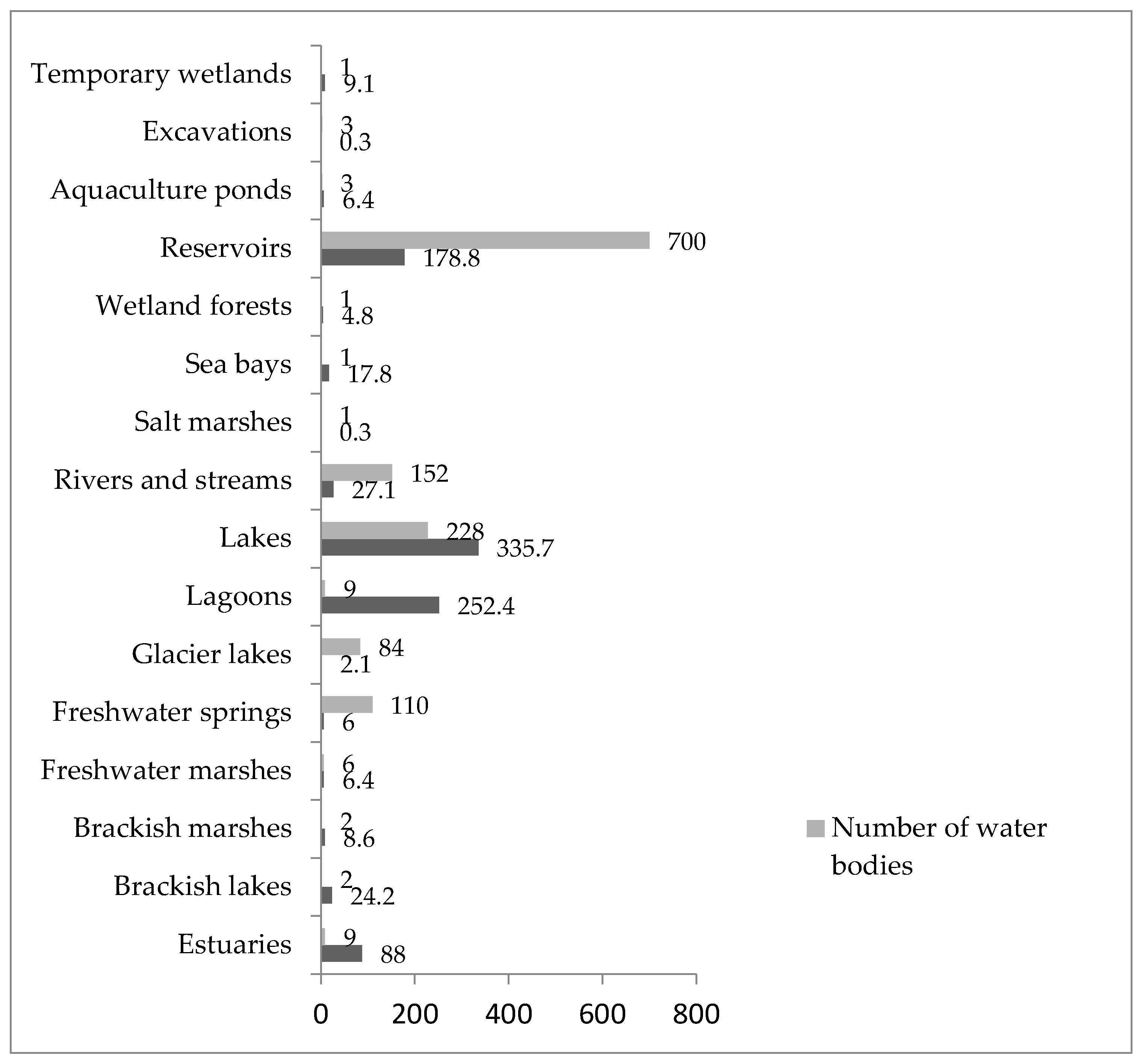
3.1. Inventory of the High Alpine Lakes in the Albanian Upland Areas

Albania’s elevation increases gradually from west to east. Plains comprise about 15% of the area, primarily in the west of the country, with hills reaching up to 200 m above sea level (Figure 2). In certain places, the mountains are arranged radially, such as the Albanian Alps, or they form regularly oriented chains, primarily oriented from the southeast to the northwest [40]. The western section of the mountains has sharper slopes than the eastern section, with flat crests and steep slopes being common features. Deep valleys are regularly squeezed by narrow gorges to create canyons such as Kelcyra (Permeti), one of the largest in Albania.
Most of the country experiences high humidity, a Mediterranean subtropical climate, which gradually shifts to a moderate continental climate in the north and east. Summers are lengthy, hot, and very dry, whereas winters are usually moderate, moist, and relatively short. There is a lot of precipitation; it increases from west to east, from roughly 1300 mm in Saranda to 2000 mm in Shkodra. When intense rainstorms occur suddenly, brooks and torrents frequently form with a high potential for erosion. Tirana receives more than 330 sunny days annually, which results in more than 2100 kWh m−2 year−1 [40].
Approximately 8% of Albanian territory, over 2300 km2, was covered by wetlands before 1960. Since then, significant agricultural reclamation projects have drastically decreased the wetlands’ overall size to less than half [40]. However, there are still more than 1300 aquatic locations spread out across the country, including rivers, lakes, ponds, coastal lagoons, marine habitats, and fluvial deltas (Figure 2). Similarly to the Dinaric arc, the glacial lakes of Albania were formed mainlyin the complex cirques and very few in the simple cirques at altitudes over 1500 m [40,41]. Glacial lakes were formed in the glacial cirques mainly on magmatic and terregine rocks [42,43].
The lake inventory contained 84 lakes above 1470 ma.s.l. in Albania, covering a total area of 2.4 km2. The lakes spread from the border withMontenegro in the north to the Gramozi Lake in the southeast, bordering Greece. The lake density, i.e., the lake area (in m2) in relation to the surface area above 1470 m (in ha), varied significantly between the mountain ranges (Table 2). The highest lake density was observed in the Albanian Alps, Korabi massif, and Pas Deje Lura area, while the lowest were in the Gramozi and Jabllanica Mountains. The highest number of glacial lakes (80%) is located within the Ohrid-Drin-Skadar system, followed by Shkumbin (11%) and then the other basins Mat and Seman (Figure 1).
Of the lakes under investigation, all have an alpine regime and a surface area of over 0.5 hectares. Of them, 42 are glacial lakes with a surface area exceeding 4 ha, while there are no lakes greater than 10 ha (Table 3). This table excludes 16 glacial lakes that were discovered to be dry in the summer and fall or that only had a very little amount of water on them in the winter and spring. The dried or temporary glacial lakes were found in the most northern region of the country, in Seferçe, with the dried Lake of Seferçe standing at an altitude of 1710 m. The glacial lakes of Albania extend from the south, where there are two temporary lakes at 1850 m above sea level in Ostrovica Mountain, to the northeast, where there is a temporary lake at 2150 m above sea level in the Panairi area. From the geo-morphological point of view, 60 glacial lakes occur in ultramafic, twelve in granitic, and twelve in calcareous geo-ecosystems, with only three in a mixed geo-morphological composition.

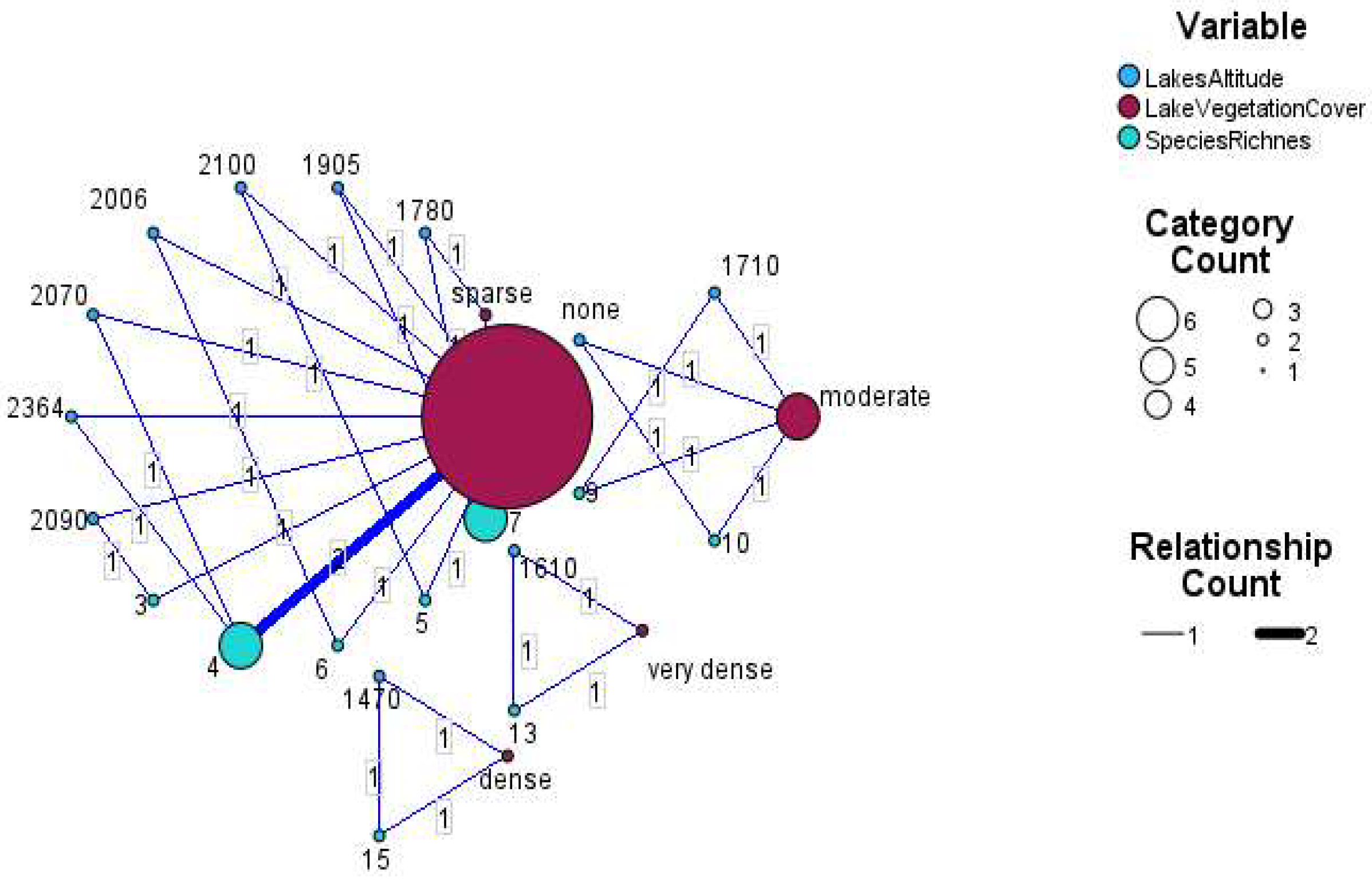
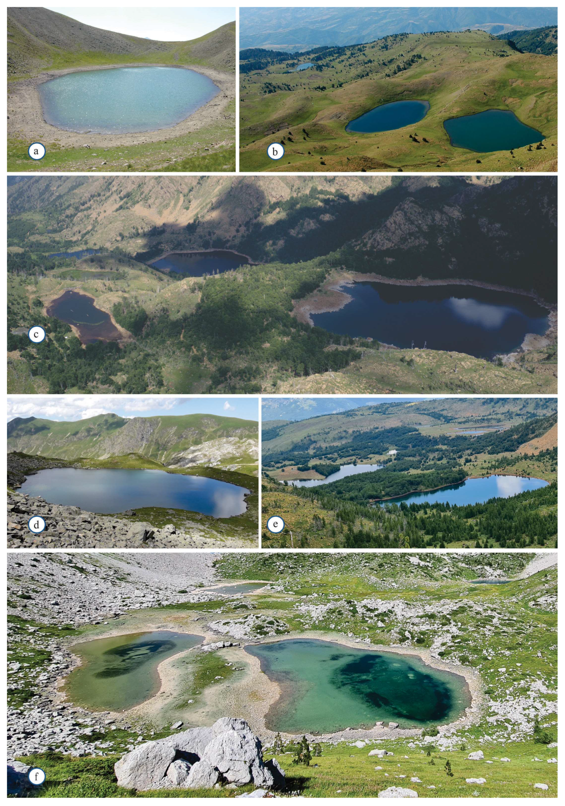
3.2. Particularities of the Glacial Lakes, Distribution, and Specific Biodiversity Values of Selected Animal and Vegetation Components

A total of N = 84 lakes were observed. The mean lake altitude is 1820.1905 ± 181.53983, and the mean water oscillation level is 1.9952 ± 0.59615. Table 3 displays the general characteristics of the surveyed lakes in Albania in the frame of vegetation cover in correlation withlake altitude, water level oscillations, and the geomorphology of the watershed of the lakes.
To understand if vegetation cover differs between lake altitudes, the water level oscillation of the lakes and the geomorphology of the watershed of the lakes, a one-way ANOVA and a Pearson (2-tailed) correlation coefficient werecalculated. The data displayed in Table 3 and Table 4 show statistically no difference in the mean between the vegetation cover of the lakes and the geomorphology of the watershed of the lakes (F(4,79) = 0.817, p = 0.518). We found a statistically significant difference in the mean of the vegetation cover of the lakes and water level oscillation (F(4,79) = 3.206, p = 9.017). Moreover, we found a statistically significant difference (F(4,79) = 4.254, p = 0.004) in the mean vegetation cover of lakes and the altitude of lakes.
  • There was a statistically significant correlation between the vegetation cover of lakes and the water level oscillation (Pearson correlation 2-tailed: R2 = −0.666, α = 99%, p < 0.001).
Glacial lakes’ rotifer biodiversity: In 2021, a checklist of Rotifera species found in Albanian inland waters and nearby areas was released [44]. There are 140 species of bdelloids and monogononts on the list, representing 38 genera. The genera that have been recorded as having the highest number of rotifers in Albanian inland waters are Lecane (16 species), Trichocerca (15 species), Brachionus (15 species), Keratella (7 species), Polyarthra (7 species), and Lepadella (6 species). Along with other types of ecosystems, small-standing water ecosystems, including those of glacial origin that are the focus of this work, are thought to be particularly important for biodiversity conservation, and proper management is urgently needed [45].There are very few publications dedicated to rotifers of glacial lakes [46,47], and the particular features noted by [48] are also the case for the Albanian glacial lakes, i.e., most of these lakes are found on mountains, above the forest line (Figure 3).
With regard to rotifers, a total of N = 14 lakes were observed. The mean of the lakes’ altitude was 1832.69 ± 285.506, and the mean of the rotifer species observed was 8.00 ± 4.340. Table 5 displays the general characteristics of the surveyed lakes in Albania in the frame of the rotifer species number observed in the lakes correlated with the lake altitude and vegetation cover (Figure 4).
The data displayed in Table 6 show no statistically significant difference in the mean between the vegetation cover of the lakes and the number of rotifer species identified in the lakes (F(8,2) = 10.205, p = 0.092). We found no statistically significant difference in the mean of the lakes’ altitudes and the number of rotifer species identified in the lakes (F(8,2) = 3.064, p = 0.269).
Presently, data for the macrophytes in the glacial lakes of Albania are very scarce. Eleven macrophyte species were reported for the Lake of Dushku, while the checklist of vascular plants inAlbania [35] and a limited number of specimens deposited in the National Herbaria in Tirana (TIR) provide the only knowledge of these ecosystems. The TIR collection includes specimens of Nymphaea alba, collected by K. Paparisto in the Black Lake of Lura (18.08.1949) and B. Ruci in White Lake (12.10.1999), Eleocharis palustris collected by B. Ruci in White Lake and Sopoti Lake (12.10.1999), Juncus articulatus collected by X. Qosja (01.08.1956) in the Black Lake of Radomira, and Myriophyllum spicatum from Lura Lakes [49].
The results of this study showed that, in 55 glacial lakes, there was no presence of aquatic macrophytes, and they were distinguished for their high transparency and low level of nutrients [49,50]. In the other 13 lakes, a cover of macrophytes was found along the peripheral areas of the lakes with shallow waters less than 20 cm, often influenced by the fluctuation in the water level during the spring–summer season; hence, the macrophyte coverage of these lakes was evaluated as sparse. The higher coverage of macrophytes was estimated in the other eleven glacial lakes; those were evaluated as dense and very dense coverage, respectively, in eight and two glacial lakes (Figure 5 and Figure 6, Table 7).
Regardless of the coverage of the investigated lakes, the number of identified aquatic plant species was low; in total, 27 macrophytes in 32 lakes were recorded. The aquatic plant species belonged to 19 genera, where Potamogeton and Carex were represented by three species, and the genus Eleocharis, Myriophyllum, Ranunculus, and Typha were represented by two species each. The genus Nymphaea, Nuphar, Ceratophyllum, Chara, Utricularia, Juncus, Polygonum, Alisma, Iris, Sparganium, Rorippa, Barbarea, and Sagittaria contributed to the floristic richness of the glacial lakes of Albania with one species each. As shown in Table 7, the lakes of Valamara and Dragani hosted the lowest number of species, respectively, three and four.
The following lakes, Kacni, Goat, Allaman, Bruçi, and Kurti, were characterized by low species richness (five species), while the other lakes, as shown in Table 7, had six to seven macrophyte species.
The highest abundance was evaluated for the white lily (Nymphaea alba) in the Lake of Dushku, Lake of Lilies (Valamara), Lake of Flowers (Allaman), Lake of Flowers (Kacni), Lake of Flowers (Lurë), Lake of Bruçi, and Kurti Lake, and there was very low abundance in the White Lake of Martaneshi. The most abundant species in the lakes with ultramafic bedrock were Eleocharis acicularis and Eleocharis palustris. Both water lilies (Nymphaea alba and Nupar lutea) occurred only in the Lake of Flowers and the Lakes of Bruçi, Kurti, and Cows in the ultramafic geo-ecosystem of Lura. Broad-leaved pond weeds (Potamogetonnatans) covered about 85% of the water surface in Dragani Lake.

3.3. Rapid Changes in Snow-Cover and Low-Temperature Days (−0 °C), Predicting Further Degradation Due to Climate Change and Anthropogenic Interventions

Following different scenarios, Albania will continue to experience a high degree of inter-annual rainfall variability [51]. A decrease in precipitation is expected (<10%), with the largest decreases occurring from June to September [52]. Further on, it is predicted that there may also be a change in the type of precipitation, as precipitation that would normally fall as snow is likely to fall as rain given the higher temperatures; this has the potential to reduce the country’s snowpack as well as the size of Albania’s ‘small glaciers’ in the Albanian Alps [53]. Among the other ecosystems, those of glacial lakes will be the first to be affected. Figure 7 shows the number of days with a temperature lower than 0 °C.
The field observations recorded different historical and current threats to the glacial lakes, which included deforestation and the overuse of natural resources, the use of water for irrigation purposes, increasing water storage, the use of water for energy production under small-scale hydropower plants, etc.
According to assessments spanning the last thirty years [54], Albania has seen a positive trend of rising temperatures for all four seasons since the year 2000 (winter: from +1.60 to + 2.5 °C; spring: from +2.00 to + 3.0 °C; summer: +3.0 °C; and autumn: +2.0 °C). The 2010 annual average temperature has already surpassed the 2020 forecast estimates. When taking into account the highest recorded air temperature, 40.4 °C, there has been a general increase in the number of days with temperatures exceeding 35 °C. With only two cases recorded prior to 2001 to 26 days in 2003 at the northwest part of the country, this has led to an increase in the recording of heat wave days, which are cases when the air temperature is at least 5 °C higher than the long-term average temperature for the corresponding days for six consecutive days, between 1961 and 2010. The frequency of heat wave days recorded has increased by up to four times in the past ten years. An examination of the probability of days with maximum temperatures over the 90th percentile supports this conclusion, demonstrating a rise in the proportion of such days from 20% of all days from 1951 to 1964 to 30% in the most recent ten years [54]. There is no trend during the same period in the number of days with cold waves, which are instances in which the air temperature is at least 5 °C lower than the long-term average temperature of the corresponding days for six consecutive days.
The Albanian Alps and the northeastern region of the country, which is home to the majority of the country’s glacial lakes, receive the most snowfall. In mountainous regions, snowfall depths range from 60 to 120 cm on average, with the Albanian Alps experiencing the maximum snowfall levels of 2–3 m. Lower amounts of rainfall fall during the June-September growing season, with the majority of the nation’s rainfall falling between November and March. The four scenarios for future climate that are based on various emission paths are referred to as “Representative Concentration Pathways” (RCPs). From RCP2.6, or the so-called “2 °C world”, to RCP 8.5, or the so-called “4 °C world”, this is the range. The projections’ reference period is 1986–2005. Most of the projections used come from two sources: the World Bank’s Climate Change Knowledge Portal (CCKP), which offers temperature and precipitation projections until 2100 for an ensemble of models, and Albania’s Third National Communication [54], which provides temperature and precipitation projections for 2050 and 2100 based on RCP.

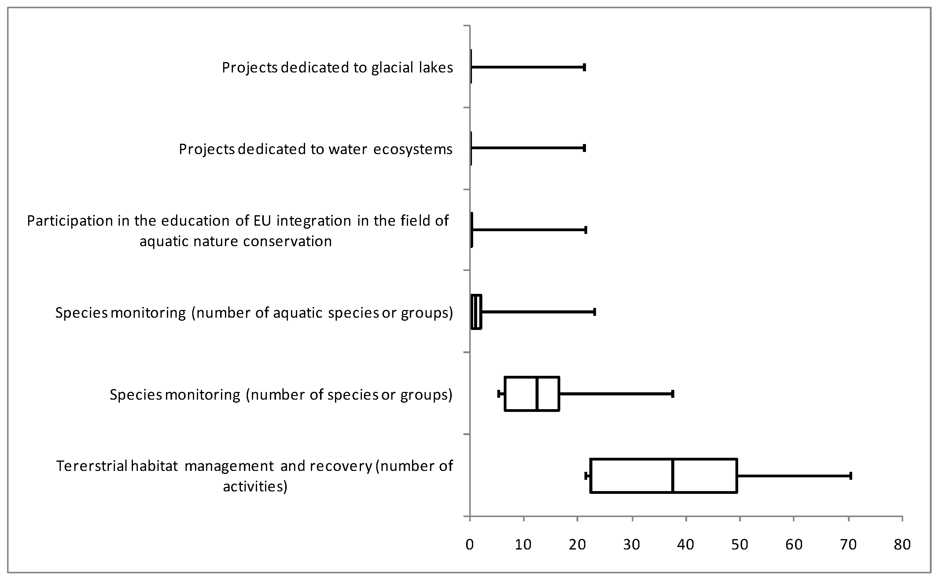
3.4. The State of Conservation and Bias with Protected Area Designation

Recent analyses [26] revealed that the government of Albania has approved a System of Environmentally Protected Areas. Currently the Network of Protected Areas of Albania reaches 504,826.3 ha, or 21% of the total area of the country. Of the total area, the Coastal and Marine Protected Areas constitute 119,224.7 ha, or 23.6% of the total surface of the NPAs of the country, of which 13,261.2 ha is marine. Moreover, 98,180.6ha have the status of Ramsar areas, which cover 3.42% of the total area of the country. A secured conservation connection offers prospects for species’ survival and life cycle performance, whereas the efficient conservation management of protected areas is a precondition for their connectivity performance [55]. Moreover, large-scale ecological and evolutionary processes, including gene flow, migration, and species range shifts, depend on the connectivity of the protected area systems.
These processes are all essential for the persistence of viable populations, especially when facing climatic and environmental changes in increasingly transformed and fragmented landscapes [56]. Improving or sustaining protected areas’ connectivity is, therefore, a primary concern for the effective conservation and management of biodiversity [57].
The foundation for the creation of the Albanian Ecological Network, or NPAs, is composed of a network of interconnected regions that have served as the basis for the establishment of corridors that span transboundary and regional contexts, as well as even larger national ones. The managerial approach considered here relates to companies (in our case, protected area authorities) and non-governmental organizations, whose goal is to effectively preserve and advance their values and functions and the informational resources in order to achieve the ecological sustainability of protected areas (in this case, glacial lake ecosystems) through ground-based activities.
The correlation between the management effectiveness score and certain numeric properties of protected areas (surface area, percent of professional staff within the total number of employees, number of rangers per surface unit, level of conservation according to legal requirements) was examined using Spearman’s rank correlation coefficient, in accordance with the non-parametric nature of the majority of the properties. The results are provided in Table 8, which contains five pairs of correlated variables. The statistical significance of the calculated Spearman’s rank correlation coefficients was confirmed with the corresponding t-test and is shown with the value of the t-statistics, with N-2 degrees of freedom, and the corresponding p-value.
According to the data presented in Table 8, there was a statistically significant positive correlation between the measured degree of effectiveness and the following properties: the surface of the protected area where glacial lakes are located, the percentage of trained staff of the entire number of employees, and the level of preservation. No statistically significant correlation was found between the score of effectiveness and the number of rangers per area.
Although fragmented, the analysis of threats conducted using different approaches such as the Management Effectiveness Tracking Tool, World Heritage Outlook Assessment [26], or BirdLife International’s Important Bird and Biodiversity Area has identified a range of threats affecting the integrity of the considered protected areas. In the following figure (Figure 8), the rate of considerations with management plans and attention to preserving fragile aquatic ecosystems and their associated biodiversity are presented. This was based on analyses of different projects implemented by protected area authorities and civil society and focused on areas where glacial lakes are located, such as the EU Natura 2000 project and the Balkan Lynx Recovery Program.
Referring specifically to important habitats for the rare, threatened, and plants of community interest, there are almost no ground conservation measures. The following plant species: Carex davalliana Sm., Carex echinata, Carex flacca Schreb., Carex vesicaria L., Eriophorum latifolium Hoppe, Geum coccineum Sibth. and Sm., Juncus effusus L., J. rticulates L., Parnassia palustris L., Polygonum bistorta L., Potentilla erecta (L.) Raeusch, Veratrum album L., or the threatened species of Centaurea vlachorum Hart, Silene parnassica subsp. pindicola (Hausskn.) Greuter, Narthecium scardicum Košanin, Pinguicula balcanica Casper, Ranunculus degenii Kümmerle and Jáv., Scilla albanica Turrill, and Soldanella pindicola Vierh., have been most abundant around Valamara, Shebenik, Balgjaj, and Lura lakes. The lake shores, water courses, and the rocky cervices of the lakes in Korabi and the Sylbicë–Doberdoli area [36,37,38] are inhabited by important relict species, such as Barbarea balcana Pančić, Caltha palustris L., Crocus bertiscensis Raca, Harpke, Shuka and V. Randjel., Galanthus elwesii Hook. F., Heliosperma pusillum subsp. albanicum (Malý) Niketić and Stevanović, Heliosperma oliverae Niketićand Stevanović, and Ranunculus degenii Kümmerle and Jáv., which confirms these sites’ conservation interest.

4. Discussion

We determined whether the vegetation cover varied with the lake elevation, water level fluctuations, and geomorphology of the watershed through analyses, as presented in Table 5; there was no statistical difference in the mean between the lakes’ vegetation cover and their geomorphological watershed (F(4,79) = 0.817, p = 0.518). The mean plant cover of the lakes and the water level oscillation were found to statistically significantly differ (F(4,79) = 3.206, p = 0.017).Furthermore, we discovered a statistically significant difference between the altitude of the lakes and their mean vegetation cover (F(4,79) = 4.254, p = 0.004).
According to different scenarios, the Mediterranean region, including Albania, will continue to see a significant level of inter-annual rainfall variability under many scenarios [48]. Precipitation is predicted to decrease (by less than 10%), with the largest reductions taking place between June and September [52]. Furthermore, given the higher temperatures, it is predicted that there may be a change in the type of precipitation as well. Precipitation that would typically fall as snow is more likely to fall as rain, which could reduce the amount of snow in the country as well as the size of Albania’s“small glaciers” in the Albanian Alps [53]. So, the ecosystems of glacial lakes will be the first to be impacted.
The climate change scenarios in Albania indicate that the temperature will continue to rise in the future as well (according to the RCP8.5 and RCP4.5 scenarios) as compared to the 1986–2005 reference period. Projected trends indicate that the mean annual temperature increase in Albania will be between 1.3°C and 2.2 °C by 2050 and between 1.2°C and 4.4°C by 2100 from the 1986–2005 baseline of 11.8°C [54]. The most significant increases would take place between June and September (5.8°C under RCP 8.5), bringing the mean summer temperature to around 27°C by 2100.
Precipitation is expected to decrease the most during the summer months (8.7 to 38.1% by 2100). However, precipitation would increase during the winter months, from1.8 to 3.2% by 2050 and from1.8 to 7.8% by 2100. Combined with warmer temperatures, this increase means that more precipitation will be in the form of rain rather than snow, causing river flows to increase in the winter and decrease in the spring, summer, and fall. Lack of snow cover, combined with increased temperature, will directly affect the glacial lakes, where normal snow covers get fed slowly during the most sensitive period of the year, as it is summer.
The large number of high-alpine lake areas and the number of lakes at elevation in Albania, as part of protected areas, provide an advantage for increased attention and conservation. Despite efforts and implemented projects, management of the protected areas remains a challenging issue, with broad national and global public implications. The goal of the current protected area management approaches is to determine which of these approaches are most appropriate and successful. In our circumstances, it is crucial to first examine whether the legal requirements that the protected area managers are required to carry out are actually being met, as this constitutes the fundamental and necessary minimum before any other analysis. The considered protected areas (and their management plans) within this analysis also paid attention to the minimal conditions, i.e., the standards foroperating in this field of work (in our case, an aquatic ecosystem), which should be completed and fulfilled. This represents an initial baseline of good management, and measuring the effectiveness and creation of the best possible management model is the upgraded superstructure of the previously set standards. As highlighted in Figure 6, the considerations and driving results following the Management Effectiveness Tracking Tool show very limited attention towards the preservation and increased resilience of the small water bodies.
The importance of rotifer biodiversity is linked with the presence of a total of 31 rotifer taxa (Brachionidae, 8 taxa; Euchlanidae, 2 taxa; Mytilinidae, 1 taxon; Lepadellidae, 3 taxa; Lecanidae, 6 taxa; Notommatidae, 1 taxon; Trichocercidae, 2 taxa; Synchaetidae, 3 taxa; Asplanchnidae, 1 taxon; Gastropodidae, 1 taxon; Testudinellidae, 1 taxon; Filiniidae, 2 taxa). According to the analyzed data, there is a linkage between rotifer species richness along different altitudinal distributions of lakes, where the Lake of Dushku (1380 m) was distinguished by 16 taxa, while the Lake of Valamare (2070 m) had 4 taxa. All the taxa identified were new records for their localities [44,45]. In regard to the studies of high mountain lakes in Albania, 31 taxa of rotifers have been reported among the zooplankton of analyzed mountain lakes, mostly inthe northeastern range, the elevation of which ranges from 1470 to 2200 m. Among them, the taxa Brachionus quadridentatus, Keratella cochlearis, K. quadrata, Notholca squamula, Euchlanis dilatata, E. incisa, Mytilina ventralis, M. ventralis brevispina, Trichotria tetractis, Colurella uncinata, Lepadella patella, L. patella similis, Lecane flexilis, L. luna, L. lunaris, L. quadrientata, Cephalodella gibba, Trichocerca longiseta, T. rattus, T. similis, T. vernalis, Synchaeta pectinata, Asplanchna priodonta, A. girodi, Testudinella patina, Conochilus unicornis, Hexarthra fennica, and Filinia longiseta were found in the present study.
Similar patterns were found in [47], revealing that, in the high mountain lakes in Turkey, 69 taxa of rotifers were reported among the zooplankton of 16 mountain lakes in the Taurus mountain range, the elevation of which ranges from 1500 to 2660 m. Among them, the taxa Brachionus, Keratella, Notholca, Euchlanis, Mytilina ventralis, Trichotria, Colurella, Lepadella, Lecane, Cephalodella, Trichocerca, Synchaeta, Asplanchna priodonta, Testudinella, Conochilus, Hexarthra, and Filinia were found to dominate.
Rotifer species richness exhibits a monotonic decline with altitude, independent of scale effects, according to a survey carried out in the Alps region [46]. In addition, the species richness may be further elucidated by considering the following: water temperature as a proxy for energy; nitrate as a proxy for human influence—discussed in our instance in terms of vegetation cover and habitat diversity; lake area as a proxy for habitat diversity; reactive silica and total phosphorus as proxies for productivity; and so on. Altitude, therefore, had no further impact on species richness, and the predictors fully explained the species richness–altitude pattern (Figure 2 and Figure 3).
Low species richness and macrophyte coverage in the glacial lakes of Albania show a strong correlation with their small surface area, in accordance with previous studies for the other Balkan lentic systems [49,58,59]. Following the results on high species richness in the Lake of Dushku compared with the lower species richness of the higher altitudinal location of the other glacial lakes, e.g., the Lake of Lilies in Valamara, the Lake of Dragani, or the Lake of Flowers in Lura, Kacnia, and Allamani range, they are in full accordance with the impact of climatic factors and altitudes [57] but not in accordance with other references [60,61,62], who connected the predominant anthropogenic pressures in lowland lakes of the Mediterranean with species loss and with a decrease in the species richness. Despite the higher anthropogenic impact observed in Lake Dushku (maximum depth of 18 m), it remains distinguished for its higher species richness and types of vegetation, unlike the other glacial lakes with dense and very dense cover vegetation. The macrophyte vegetation of Dragani Lake covers 90% and is composed only of submersed benthic hydrophytes dominated by Potamogeton natans, which have not been found elsewhere in the glacial lakes of Albania. The macrophyte vegetation inthe Lake of Flowers (94%), Kurti Lake (55%), and the Lake of Bruçi (65%) in the Lura geo-ecosystem is dominated by floating-leaved vegetation of N. alba and N. lutea. Yellow lily was not found in other glacial lakes in the country.
The submersed benthic hydrophyte vegetation of Nymphaea alba, accompanied by other helophytes such as Eleocharis acicularis or E. palustris and Carex spp., dominated in the Lake of Lilies (Valamara), the Lake of Flowers (Allamani and Kacni areas), and the Lake of Kacnia 1. All the above lakes are characterized by a depth of less than 2 m and a high biomass accumulation of helophytes species, contributing to primary productivity, sediment accumulation and stabilization, and the storage and cycling of nutrients, which, according to [22], accelerate their deterioration. The relict, endemic, and subendemic species such as Barbarea balcana, Centaurea vlachorum, Crocus bertiscensis, Heliosperma pusillum subsp. albanicum and Heliosperma. oliverae, S. parnassica subsp. pindicola, Nartheciumscardicum, Pinguicula balcanica, Ranunculus degenii, Scilla albanica, and Soldanella pindicola, recorded in the shores and the belt around the glacial lakes in Albania [36,37,58] might be considered good indicators for the water quality and habitat integrity.
The historical and current threats to the glacial lakes and their basins, such as the deforestation and overuse of natural resources, the use of water for irrigation purposes, increasing water storage, and the use of water for energy production of small-scale hydropower plants, seem to accelerate the deterioration of integrity.
The relationship between the management effectiveness scores and a few external factors—such as the surface area, the proportion of staff with training, the number of rangers per surface unit, and the national protected area classification—was studied in relation to the management effectiveness along the protected areas that include glacial lakes. The results of the analysis show that there is a substantial relationship between the management effectiveness score and the classification of national protected areas, surface area, and the proportion of trained personnel among all employees. It is evident that more work and ground-based methods are required in light of the lack of a statistically significant association between the effectiveness of the protected area and the number of rangers stationed there. More analysis is required to take this and related factors into account. In terms of other components, the outcomes are anticipated because professional staff is primarily responsible for managing protected areas; that is, higher conservation levels are predicted to result in stricter conservation implementation measures within specific protected areas.

5. Conclusions

As a conclusion and following the data and analyses, the authors conclude that: (i) the current management plans for the considered protected areas do not meet the minimum requirements for adequate management in terms of the legally prescribed management criteria. (ii) The inventory revealed the presence of 84 glacial lakes. (iii) Following the analysis of additional issues, they conclude that aquatic ecosystems form the category of the most vulnerable ecosystems. The glacial lakes reflect climate change elements through an increased number of dried glacial lakes, so only 84 remain functioning; the water level is slowly being reduced; the oscillation of the water level is steadily increasing, and the eutrophication process is rapidly advancing. (iv) The results indicate that the management effectiveness of the protected areas needs to be employed within standard practices in the management of protected areas, including all types of ecosystems. Further measures to build the resilience of aquatic ecosystems are vital for preserving biodiversity values and halting further glacial lake degradation. This needs to be linked with mitigation (in the energy sector, the water sector, the agriculture sector, etc.) and adaptation measures (covering research gaps, data and information gaps, water resources, agriculture, soils, disaster risk management, etc.).We consider the lake inventory a valuable approach for further analyses and projections towards mainstreaming proper conservation efforts. A crucial issue remains the fact that by reducing our carbon footprint and advocating for climate-friendly policies, we contribute to slowing down glacial lakes and preserving them. In the case of upland areas, this also means making changes in our daily lives: using energy-efficient appliances, opting for public transport or cycling, and promoting slow food approaches.

Author Contributions

Conceptualization S.S. and L.S. (Laura Shumka); methodology, S.S. and L.S. (Laura Shumka); validation, S.S, L.S. (Laura Shumka), L.S. (Lulëzim Shuka) and M.Š.; formal analysis, S.S.; investigation, S.S. and L.S. (Lulëzim Shuka); resources, S.S.; data curation, L.S. (Lulëzim Shuka); writing—original draft preparation, S.S. and L.S. (Laura Shumka); writing—review and editing, S.S.; visualization, L.S. (Lulëzim Shuka) and S.S.; Supervision, S.S.; project administration, M.Š. All authors have read and agreed to the published version of the manuscript.

Funding

This research received no external funding.

Data Availability Statement

Readers can contact the authors for data and materials.

Conflicts of Interest

The authors declare no conflicts of interest.

References

  1. Cowie, R.H.; Bouchet, P.; Fontaine, B. The Sixth Mass Extinction: Fact, fiction or speculation? Biol. Rev. 2022, 97, 640–663. [Google Scholar] [CrossRef] [PubMed]
  2. WWF. Living Planet Report 2022—Building a Nature positive Society; Almond, R.E.A., Grooten, M., Bignoli, J., Petersen, T., Eds.; WWF Gland Switzerland: Gland, Switzerland, 2022; p. 118. [Google Scholar]
  3. Markovic, D.; Carrizo, S.; Carcher, O.; Walz, A.; David, J. Vulnerability of European freshwater catchments to climate change. Glob. Chang. Biol. 2017, 23, 3567–3580. [Google Scholar] [CrossRef]
  4. Shumka, L.; Papastefani, A.; Shumka, S.; Mali, S. The Potentials for the Ecological Management of Landscape Connectivity Including Aquatic Ecosystems in Northeast Albania. Hydrobiology 2023, 2, 44–54. [Google Scholar] [CrossRef]
  5. European Commission, Directorate-General for Environment. EU Biodiversity Strategy for 2030—Bringing Nature Back into Our Lives; Publications Office of the European Union: Luxembourg, 2021. [CrossRef]
  6. UN Environment Programme. Monitoring framework for the Kunming-Montreal Global Biodiversity Framework. In Proceedings of the Conference of the Parties to the Convention on Biological Diversity Fifteenth Meeting, Montreal, QC, Canada, 5–17 December 2022. [Google Scholar]
  7. Da Silva, J.P.; Hermoso, V.; Lopes-Lima, M.; Miranda, R.; Filipe, A.F.; Sousa, R. The role of connectivity in conservation planning for species with obligatory interactions: Prospects for future climates cenarios. Glob. Chang. Biol. 2024, 30, e17169. [Google Scholar] [CrossRef]
  8. Bocchiola, D.; Guglielmina, D. Evidence of climate change within the Adamello Glacier of Italy. Theor. Appl. Climatol. 2010, 100, 351–369. [Google Scholar] [CrossRef]
  9. Theurillat, J.P.; Guisan, A. Potential impact of climate change on vegetation in the European Alps: Areview. Clim. Chang. 2001, 50, 77–109. [Google Scholar] [CrossRef]
  10. Beniston, M.; Keller, F.; Goyette, S. Snow pack in the Swiss Alps under changing climatic conditions: An empirical approach for climate impacts studies. Theor. Appl. Climatol. 2003, 74, 19–31. [Google Scholar] [CrossRef]
  11. Paul, F.; Kääb, A.; Haeberli, W. Recent glacier changes in the Alps observed by satellite: Consequences forfuture monitoring strategies. Glob. Planet. Chang. 2007, 56, 111–122. [Google Scholar] [CrossRef]
  12. Buckel, J.; Otto, J.C.; Prasicek, G.; Keuschnig, M. Glacial lakes in Austria—Distribution and formation since the Little Ice Age. Glob. Planet. Chang. 2018, 164, 39–51. [Google Scholar] [CrossRef]
  13. Zemp, M.; Hoelzle, M.; Haeberli, W. Distributed modelling of the regional climatic equilibrium line altitude of glaciers in the EuropeanAlps. Glob. Planet. Chang. 2007, 56, 83–100. [Google Scholar] [CrossRef]
  14. Hughes, P.D.; Woodward, J.C.; Gibbard, P.L. Relict rock glaciers as indicators of Mediterranean palaeo climate during the Last Glacial Maximum (Late Würmian) in northwest Greece. J. Quat. Sci. 2003, 18, 431–440. [Google Scholar] [CrossRef]
  15. Reuther, A.U.; Urdea, P.; Geiger, C.; Ivy-Ochs, S.; Niller, H.P.; Kubik, P.W.; Heine, K. Late Pleistocene glacial chronology of the Pietrele valley, Retezat mountains, southern Carpathians, constrained by 10 Beexposure ages and pedological investigations. Quat. Int. 2007, 164, 151–169. [Google Scholar] [CrossRef]
  16. Milivojević, M.; Menković, L.; Calić, C. Pleistocene glacial relief of the central part of Mt. Prokletije (Albanian Alps). Quat. Int. 2008, 190, 112–122. [Google Scholar] [CrossRef]
  17. Frasheri, A.; Bushati, S.; Bare, V. Geophysical outlook on structure of the Albanides. J. Balk. Geophys. Soc. 2009, 12, 9–30. [Google Scholar]
  18. Wetzel, R.G. Limnology: Lake and River Ecosystems, 3rd ed.; Academic: San Diego, CA, USA, 2001; p. 1006. ISBN 9780127447605. [Google Scholar]
  19. Sharma, R.C. Habitat ecology and diversity of freshwater zooplankton of Uttarakh and Himalaya, India. Biodivers. Int. J. 2020, 5, 188–196. [Google Scholar]
  20. Gavrilko, D.; Zhikharev, V.; Zolotareva, T.; Kudrin, I.; Yakimov, B.; Erlashova, A. Biodiversity of zooplankton (Rotifera, Cladocera and Copepoda) in the tributaries of Cheboksary Reservoir (Middle Volga, Russia). Biodivers. Data J. 2024, 12, e116330. [Google Scholar] [CrossRef]
  21. Søndergaard, M.; Johansson, L.S.; Lauridsen, T.L.; Jørgensen, T.B.; Liboriussen, L.; Jeppesen, E. Submerged macrophytes as indicators of the ecological quality of lakes. Freshw. Biol. 2010, 55, 893–908. [Google Scholar] [CrossRef]
  22. Steffenhagen, P.; Zak, D.; Schulz, K.; Timmermann, T.; Zerbe, S. Biomass and nutrient stock of submersed and floating macrophytes in shallow lakes formed by rewetting of degraded fens. Hydrobiologia 2012, 692, 99–109. [Google Scholar] [CrossRef]
  23. EC(EuropeanCommission). Directive 2000/60/EC of the European Parliament and of the Council of 23rd October 2000 establishing a framework for Community action in the field of water policy. In Official Journal of the European Communities; L327/1; European Commission: Brussels, Belgium, 2020. [Google Scholar]
  24. Rigó, A.; Barina, Z. The Floristic Composition of Irrigation Ponds and Water Reservoirs in Albania after the Long Persistent Drought of 2016–2017. In Proceedings of the 1st International Electronic Conference on Biological Diversity, Ecology and Evolution, Basel, Switzerland, 15–31 March 2021; pp. 132–140. [Google Scholar] [CrossRef]
  25. Abell, R.; Thieme, M.L.; Revenga, C.; Bryer, M.; Kottelat, M.; Bogutskaya, N.; Coad, B.; Mandrak, N.; Balderas, S.C.; Bussing, W.; et al. Freshwater Ecoregions of the World: A New Map of Biogeographic Units for Freshwater Biodiversity Conservation. BioScience 2008, 58, 403–414. [Google Scholar] [CrossRef]
  26. Shumka, S.; Berberi, E.; Kulici, M.; Mucaj, S.; Vladi, F. Assessing the relationship between biodiversity conservation and slow food culture in selected protected areas in Albania. Biodiversitas 2022, 23, 1319–1326. [Google Scholar] [CrossRef]
  27. Shumka, S.; Lalaj, S.; Šanda, R.; Shumka, L.; Meulenbroek, P. Recent data on the distribution of freshwater ichthyofauna in Albania. Croat. J. Fish. 2023, 81, 33–44. [Google Scholar] [CrossRef]
  28. UNESCO. Enhancing Our Heritage Toolkit Assessing Management Effectiveness of Natural World Heritage Sites; UNESCO World Heritage Centre: Paris, France, 2008; pp. 1–134.
  29. Nogrady, T.; Segers, H. Asplanchnidae, Gastropodidae, Lindiidae, Microcodidae, Synchaetidae, Trochosphaeridae and Filinia. In Rotifera. Guides to the Identification of the Microinvertebrates of the Continental Waters of the World; Backhuys Publishers: Leiden, The Netherlands, 2002; Volume 6. [Google Scholar]
  30. Ruttner-Kolisko, A. Plankton Rotifers, Biology and Taxonomy. English translation of Die Binnengenwasser; Schweizerbart: Sttutgart, Germany, 1974. [Google Scholar]
  31. Koste, W. Rotatoria, Die Radertiere Mitteleuropas. Ein Bestimmungswerk, be grundet von Max Voigt. In Uberordnung Monogononta; Gebruder Borntraeger: Berlin, Germany, 1978. (In German) [Google Scholar]
  32. Collin, A.; Dieffenbach, H.; Sachse, R.; Voigt, M. Rotatoria und Gastrotricha; Die Susswasser fauna Deutschlands: Lehre, Germany, 1961. [Google Scholar]
  33. Nogrady, T.; Pourriot, R.; Segers, H. Rotifera. Guides to the Identification of the Microinvertebrates of the Continental Waters of the World. In The Notommatidae and the Scaridiidae; SPB Academic Publishing: The Hague, The Netherlands, 1995; Volume 3. [Google Scholar]
  34. Tutin, T.G.; Burges, N.A.; Chater, A.O.; Edmondsn, J.R.; Heywood, V.H.; Moore, D.M.; Valentine, D.H.; Walters, S.M.; Webb, D.A. Flora Europeae. I–V; Cambridge University Press: Cambridge, UK, 1993. [Google Scholar]
  35. Barina, Z.; Somogyi, G.; Pifko, D.; Rakaj, M. Checklist of vascular plants of Albania. Phytotaxa 2018, 378, 1–339. [Google Scholar] [CrossRef]
  36. Raca, I.; Harpke, D.; Shuka, L.; Ranđelović, V. A new species of Crocus ser. Verni (Iridaceae) with 2n=12 chromosomes from the Balkans, Plant Biosyst.-Int. J. Deal. All Asp. Plant Biol. 2020, 156, 36–42. [Google Scholar] [CrossRef]
  37. Shuka, D.; Tan, K.; Hallaçi, B.; Shuka, L. Additions to the flora of North Albania. Phytol. Balc. 2020, 26, 517–522. [Google Scholar]
  38. Kohler, A. Methodender Kartierungv on Flora und Vegetation von Sus wasser biotopen. Landsch. Stadt. 1978, 10, 73–85. [Google Scholar]
  39. Trajanovska, S.; Talevska, M.; Schneider, S. Assessment of littoral eutrophication in LakeOhrid by submerged macrophytes. Biologia 2014, 69, 756–764. [Google Scholar] [CrossRef]
  40. Miho, A.; Kashta, L.; Beqiraj, S. Between the Land and the Sea—Ecoguide to Discover the Transitional Waters of Albania; Julvin2: Tirana, Albania, 2013; pp. 1–462. ISBN 978-9928-137-27-2. [Google Scholar]
  41. Hughes, P.D.; Woodward, J.C.; van Calsteren, P.C.; Thomas, L.E. The glacial history of the Dinaric Alps, Montenegro. Quat. Sci. Rev. 2011, 30, 3393–3412. [Google Scholar] [CrossRef]
  42. Hughes, P.D.; Gibbard, P.L.; Woodward, J.C. Geological controls on Pleistocene glaciation and cirque form in Greece. Geomorphology 2007, 88, 242–253. [Google Scholar] [CrossRef]
  43. Hughes, P.D. Twenty-first Century Glaciers and Climate in the Prokletije Mountains, Albania. Arct. Antarct. Alp. Res. 2009, 41, 455–459. [Google Scholar] [CrossRef]
  44. Shumka, S. Checklist of Rotifer Species from Albania (Phylum Rotifera). Opusc. Zool. 2021, 52, 99–109. [Google Scholar] [CrossRef]
  45. Špoljar, M.; Shumka, S.; Tasevska, O.; Tomljanovic, T.; Otoic, A.; Galir Balkic, A.; Lajtner, J.; Pepa, B.; Dražina, T.; Ternjej, I. Small Standing-Water Ecosystems in the Transitional Temperate Climate of the Western Balkans; Springer: Berlin/Heidelberg, Germany, 2021; pp. 21–51. [Google Scholar] [CrossRef]
  46. Obertegger, U.; Thaler, B.; Flaim, G. Rotifer species richness a longanaltitudinal gradient in the Alps. Glob. Ecol. Biogeogr. 2010, 19, 895–904. [Google Scholar] [CrossRef]
  47. Özdemir, M.D.; Ustaoğlu, M.R. Distribution of rotifers of high mountain lakes in the Eastern Black Sea Range of Turkey. Turk. J. Zool. 2017, 41, 674–685. [Google Scholar] [CrossRef]
  48. Sturm, R. Freshwater molluscs in mountain lakes of the Eastern Alps (Austria): Relationship between environmental variables and lake colonization. J. Limnol. 2007, 66, 160–169. [Google Scholar] [CrossRef]
  49. Schneider, S.; Trajanovska, S.; Biberdžić, V.; Marković, A.; Talevska, M.; Imeri, A.; Cara, M. The Balkan macrophyte index (BMI) for assessment of eutrophication in lakes. Acta Zool. 2020, 72, 439–454. [Google Scholar]
  50. Mancinelli, G.; Mali, S.; Belmonte, G. Species richness and taxonomic distinctness of zooplankton in ponds and small lakes from Albania and North Macedonia: The role of bioclimatic factors. Water 2019, 11, 2384. [Google Scholar] [CrossRef]
  51. World Bank. Climate Risk Profile: Albania; The World Bank Group, World Bank Publications: Washington, DC, USA, 2021; p. 34. [Google Scholar]
  52. Hodenbrog, L.; Marelle, L.; Alterskjær, K.; Wood, R.R.; Ludwig, R.; Fischer, E.M.; Richardson, T.B.; Forster, P.M.; Sillman, J.; Myhre, G. Intensification of summer precipitation with shorter time-scales in Europe. Environ. Res. Lett. 2019, 14, 124050. [Google Scholar] [CrossRef]
  53. Grunewald, K.; Scheithauer, J. Europe’s southern most glaciers: Response and adaptation to climate change. J. Glaciol. 2010, 56, 129–142. [Google Scholar] [CrossRef]
  54. Ministry of Environment. Albania’s Second National Communication to the Conference of Parties under the UNFCCC; Ministry of Environment: Tirana, Albania, 2016; p. 296.
  55. Saura, S.; Bertzky, B.; Bastin, L.; Battistella, L.; Mandrici, A.; Dubois, A. Protected area connectivity: Shortfalls in global targets and country-level Priorities. Biol. Conserv. 2018, 219, 53–67. [Google Scholar] [CrossRef] [PubMed]
  56. Beale, C.M.; Baker, N.E.; Brewer, M.J.; Lennon, J.J. Protected area networks and savannah bird biodiversity in the face of climate change and land degradation. Ecol. Lett. 2013, 16, 1061–1068. [Google Scholar] [CrossRef]
  57. Juffe-Bignoli, D.; Burgess, N.D.; Bingham, H.; Belle, E.M.S.; de Lima, M.G. Protected Planet Report; UNEP-WCMC: Cambridge, UK, 2014. [Google Scholar]
  58. Miszczak, S.; Shuka, D.; Shuka, L.; Migdalek, G.; Słomka, A. Low and high elevation Heliosperma species (Caryophyllaceae)—Insight based on chromosome number, pollen characters and seed micromorphology. Phytotaxa 2022, 554, 32–46. [Google Scholar] [CrossRef]
  59. Oikonomou, A.; Stefanidis, K. α-and β-diversity patterns of macrophytes and freshwater fishes are driven by different factors and processes in lakes of the unexplored southern Balkan biodiversity hot spot. Water 2020, 12, 1984. [Google Scholar] [CrossRef]
  60. Chappuis, E.; Gacia, E.; Ballesteros, E. Environmental factors explaining the distribution and diversity of vascular aquatic macrophytes in a highly heterogeneous Mediterranean region. Aquat. Bot. 2014, 113, 72–82. [Google Scholar] [CrossRef]
  61. Fernández-Aláez, C.; Fernández-Aláez, M.; García-Criado, F.; García-Girón, J. Environmental drivers of aquatic macrophyte assemblages in ponds a longanaltitudinal gradient. Hydrobiologia 2016, 812, 79–98. [Google Scholar] [CrossRef]
  62. Shuka, L.; Çullaj, A.; Shumka, S.; Miho, A.; Duka, S.; Bachofen, R. Response of Drinking-Water Reservoir Ecosystems to Anthropogenic Impacts in Albania: Trends of Interrelationship. J. Int. Environ. Appl. Sci. 2009, 4, 478–486. [Google Scholar]
Figure 1. Albania’s water basin systems: the Ohrid–Drin–Skadar system (including River Buna) (A), Mat (B), Ishëm (C), Erzen (D), Shkumbin (E), Seman (F), Vjosa (G), the region surrounding the Butrint Lagoon (rivers Bistrica and Pavllo) (I), and the tributaries of the Ionian Sea (H).
Climate 12 00124 g001
Figure 2. Number of water bodies and their surface area.
Climate 12 00124 g002
Figure 3. Relationship map.
Climate 12 00124 g003
Figure 4. Relationship map of rotifers and other selected variables.
Climate 12 00124 g004
Figure 5. Selected glacial lakes: (a) Lake of Gramozi, (b) Lakes on Valmara, (c) Lakes of Kacnia in Balgjaj, (d) Lake of Dashi in Sylbica–Doberdol, (e) Lake of Lura and (f) Lakes of Jezerca. (Author of photos: L.Shuka).
Climate 12 00124 g005
Figure 6. (a) Great Lake covered by snow in Lura, (b) Dried Lake of Panairi in Korab, (c) Yellow Lake and endemic saffron (Crocus bertiscensis) during early spring, (d) floating-leaved vegetation dominated by Nymphaea alba in the Lake of Lilies (Valamara), (e) floating-leaved vegetation dominated by Nymphaea alba and Nuphar lutea in the Lake of Bruçi (Lura), (f) vegetation of submersed benthic hydrophytes dominated by Potamogeton natans in the Lake of Dragani (Shebenik–Jabllanica, and (g) sparse vegetation cover in Goat Lake (Allamani) (Author of photos: L.Shuka).
Climate 12 00124 g006
Figure 7. Number of days with a temperature lower than 0 °C (Data source: Institute of Geosciences, Environment and Meteorology, Tirana).
Climate 12 00124 g007
Figure 8. Box plot “Box and whiskers” showing the conservation efforts and investments for the preservation of glacial lake ecosystems and their associated biodiversity.
Climate 12 00124 g008
Table 1. Variables selected for analysis.
Group IGroup II
Level 1Level 2Level 3
Management planYearly revision of management planNumber of implemented projects, 2017–2023
Trained staffDatabase of performanceGlacial lake monitoring
Ranger serviceDaily operational and guidance bookEducation programs
Biodiversity inventory database
Hiking trails
Visitor center and guided tours
Table 2. Main characteristics of the 84 glacial lakes.
No.Lake NameCoordinatesAltitude (m)Geomorphology of Watershed
(According to [17])
Vegetation CoverSurface (ha)Yearly Water Level
Oscillation (m)
1Gramozi Lake40°21′52.17″ N20°47′25.62″ E2364Flysch alevroliticNone0.481.50
Jabllanica Mt
2Lake of Dragani41°16′54.71″ N20°27′2.33″ E1660CalcareousVery dense7.13.50
3Lake of Kusar41°16′38.32″ N20°30′1.77″ E1862Mixed Calcareous and GraniticNone1.152.01
4Lake of Sal Xhyra41°15′56.87″ N20°29′59.60″ E1850Mixed Calcareous and GraniticNone0.772.10
Shebeniku Mt
5Big lake of Dragostunja41°12′43.50″ N20°27′43.20″ E2054Ultramafic rocksNone1.561.75
6Great Lake of Dragostunja41°12′45.73″ N20°27′31.28″ E2005Ultramafic rocksNone1.151.50
7Shebenik Lake41°12′49.81″ N20°28′4.00″ E2006Ultramafic rocksNone1.521.40
8Great Lake of Likopatra, Rrajcë41°11′21.78″ N20°29′22.42″ E1905Ultramafic rocksNone3.541.20
9Small Lake of Likopatra, Rrajcë41°11′30.98″ N20°29′5.86″ E2007Ultramafic rocksNone1.541.20
Valamara Mts
10Black Lake (Lenia)40°45′39.98″ N20°25′50.26″ E1698Ultramafic rocksNone3.252.30
11Black Lake of Valamara40°46′40.10″ N20°28′0.16″ E2003Ultramafic rocksNone1.931.71
12Lake in Valamara40°46′20.70″ N20°28′17.99″ E1950Ultramafic rocksNone0.81.81
13Lake of Lilies (Valamara)40°46′55.44″ N20°29′24.71″ E1865Ultramafic rocksDense21.75
14Lake in Valamara 340°46′51.03″ N20°29′4.37″ E1910Ultramafic rocksNone3.92.01
15Lake of Lenia40°47′17.35″ N20°28′16.41″ E2110Ultramafic rocksNone2.92.10
16Lake in Valamara 440°47′20.00″ N20°28′05.06″ E2121Ultramafic rocksNone2.371.40
17The Lake of the Spring of Shkumbin40°47′48.40″ N20°28′6.32″ E2147Ultramafic rocksNone21.31
18Lake in Valamara 540°47′36.96″ N20°28′38.06″ E2020Ultramafic rocksNone0.41.40
19Lake of Lukova 140°54′21.62″ N20°23′43.29″ E1855Ultramafic rocksNone6.531.91
20Lake of Lukova 240°53′53.80″ N20°24′21.60″ E1750Ultramafic rocksNone4.071.30
Martanesh area
21Lake of Sopa41°26′5.87″ N20°17′16.73″ E1722Ultramafic rocksSparse3.221.35
22Lake of Hardha41°26′26.12″ N20°18′38.71″ E1725Ultramafic rocksNone7.31.90
23Lake of Sopoti41°27′6.15″ N20°18′51.51″ E1632Ultramafic rocksSparse72.10
24Black Lake (Bulqiza)41°27′15.16″ N20°18′7.29″ E1687Ultramafic rocksNone23.01
25White Lake41°27′41.28″ N20°17′43.43″ E1650Ultramafic rocksSparse7.43.012
26Lake Kocebse41°28′25.10″ N20°15′39.01″ E1798Ultramafic rocksSparse2.132.10
27Dry Lake41°28′15.67″ N20°15′10.82″ E1798Ultramafic rocksSparse3.82.01
28Skënderi Lake41°28′27.02″ N20°14′45.74″ E1725Ultramafic rocksSparse3.21.80
29Lake without tracks41°28′4.39″ N20°14′42.34″ E1860Ultramafic rocksNone1.21.60
30Gatelli Lakes41°28′4.39″ N20°14′42.34″ E1810Ultramafic rocksSparse2.31.70
31Balgjai Lake41°33′16.53″ N20°12′49.33″ E1775Ultramafic rocksNone11.75
32Balgjai Lake 241°33′11.06″ N20°12′28.41″ E1808Ultramafic rocksNone4.51.80
33Lake of flowers (Kacni)41°33′37.55″ N20°13′25.69″ E1900Ultramafic rocksDense6.11.81
34Lake of Ksnika41°33′58.10″ N20°14′28.84″ E1855Ultramafic rocksNone1.441.75
35Black Lake of Kacnia41°34′6.51″ N20°13′55.42″ E1855Ultramafic rocksNone101.80
36Lake of Shtrunga41°34′23.00″ N20°14′17.30″ E1690Ultramafic rocksNone63.10
37Lake of Barzana41°34′23.75″ N20°13′52.16″ E1800Ultramafic rocksSparse21.50
38Lake of Kacnia 141°34′29.70″ N20°14′5.70″ E1740Ultramafic rocksDense1.721.70
39Lake of Kacnia 241°34′37.37″ N20°14′19.53″ E1665Ultramafic rocksSparse23.50
40Lake of Bruce41°34′18.16″ N20°15′15.14″ E1665Ultramafic rocksNone1.93.01
41Lake of Milloshi41°34′35.29″ N20°15′20.05″ E1636Ultramafic rocksNone2.52.40
42Lake of Kalia41°34′43.66″ N20°15′17.02″ E1655Ultramafic rocksNone22.20
43Lake of Batakëve 141°34′29.00″ N20°15′5.14″ E1686Ultramafic rocksSparse1.21.80
44Lake of Batakëve 241°34′19.41″ N20°15′0.57″ E1715Ultramafic rocksModerate11.60
45Lake of Batakëve 341°34′9.58″ N20°15′3.87″ E1773Ultramafic rocksSparse2.51.50
Allamani Lakes
46Lake of Micekut41°34′10.54″ N20°13′2.00″ E1860Ultramafic rocksNone4.11.70
47Lake of Allamani41°34′27.30″ N20°12′46.85″ E1784Ultramafic rocksNone5.341.60
48Goat Lake41°34′41.09″ N20°12′49.19″ E1780Ultramafic rocksSparse1.71.30
49Lake of Flowers (Allaman)41°34′58.98″ N20°12′49.46″ E1805Ultramafic rocksDense1.221.35
50Lake of Kolë Madhi41°35′14.77″ N20°13′40.09″ E1715Ultramafic rocksModerate32.60
Pas Deja Lura
51The stone of Virgo41°40′40.82″ N20°12′22.27″ E1555Ultramafic rocksNone3.153.01
52Lake of Pas Deja41°41′15.32″ N20°10′48.81″ E1892Ultramafic rocksNone0.442.01
53Lake of Flowers (Lura)41°44′23.01″ N20°11′55.45″ E1588Ultramafic rocksNone1.442.30
54Kallaba Lake41°44′32.19″ N20°11′49.31″ E1594Ultramafic rocksModerate4.162.20
55The Dryed Lake41°45′5.52″ N20°11′55.41″ E1636Ultramafic rocksNone2.641.91
56Black Lake, Lurë41°45′8.89″ N20°11′35.56″ E1743Ultramafic rocksNone2.562.20
57Hoti Lake41°45′51.55″ N20°11′36.86″ E1683Ultramafic rocksNone1.842.50
58Lake of Bruçi41°47′17.97″ N20°11′46.25″ E1724Ultramafic rocksDense0.72.01
59Kurti Lake41°47′17.89″ N20°12′0.08″ E1683Ultramafic rocksDense1.12.10
60Lake of Rrasave41°47′33.47″ N20°11′42.88″ E1710Ultramafic rocksSparse42.02
61Lake in Lura41°47′31.59″ N20°11′31.77″ E1730Ultramafic rocksSparse0.42.50
62Lake of Cows41°47′58.60″ N20°11′20.81″ E1620Ultramafic rocksDense1.52.50
Korabi Mts
63Lake of Ladys41°45′22.79″ N20°30′29.15″ E1884Granitic rocksDense1.71.80
64Grama Lake 41°45′34.20″ N20°29′35.71″ E1754Granitic rocksNone51.75
65Lakes of Steps41°47′58.12″ N20°30′4.53″ E1786CalcareousModerate0.71.70
66Black Lake, Radomira41°49′12.26″ N20°29′13.54″ E1470Granitic rocksModerate0.82.80
Sylbicë-Doberdol
67Lake of Zanave42°30′59.12″ N20° 5′4.61″ E2207Granitic rocksNone0.90.80
68Lake of Black Peak42°31′9.03″ N20° 5′0.44″ E2215Granitic rocksNone0.71.10
69Sylbica Lake42°31′34.13″ N20° 5′23.25″ E2090Granitic rocksSparse31.51
70Yellow Lake42°31′15.59″ N20° 5′20.66″ E2087Granitic rocksNone1.11.10
71Lake of Dogs42°31′21.56″ N20° 5′6.77″ E2135Granitic rocksNone1.11.21
72Southern Lake42°30′29.75″ N20° 5′47.21″ E2000Granitic rocksNone0.51.75
73Lake of Sheep42°30′16.59″ N20° 6′4.01″ E2010Granitic rocksNone11.80
74Lake of Dashi42°31′47.24″ N20° 4′36.82″ E2180Granitic rocksNone3.52.01
75Beri Lake42°32′21.87″ N20° 4′25.22″ E1994Granitic rocksModerate0.72.01
Albanian Alps
76Lake of Lulashi42°28′5.23″ N19°49′0.61″ E1665CalcareousNone1.31.90
77Lake of Shalë42°28′11.16″ N19°48′44.75″ E1755CalcareousNone1.472.50
78Lake of Lohjanit42°28′4.94″ N19°48′40.08″ E1757CalcareousNone2.632.60
79Lake of Mjelsave42°27′55.40″ N 19°48′31.38″ E1806CalcareousNone1.22.70
80Great Lake of Jezerca42°27′39.34″ N19°48′23.68″ E1795CalcareousNone4.32.80
81Lake of SheuiBardhë42°27′27.42″ N19°46′22.64″ E1672CalcareousNone0.72.90
82Lake of Peshkeqes42°26′51.13″ N19°46′14.50″ E1616CalcareousNone0.73.10
83Ponari Lake42°22′12.03″ N22°00′50.08″ E1363CalcareousModerate2.22.80
84Lake of Kelmendi fortress42°27′5.22″ N19°42′45.38″ E1757CalcareousNone1.21.80
Table 3. Descriptive statistics for different variables performed using SPSS 29.00.
VariablesVegetation CoverFrequency (N)Mean ± Std. Deviation
Lakes Altitudenone541870.45 ± 187.16
sparse131761.85 ± 113.60
moderate81638.50 ± 154.24
dense81777.62 ± 102.00
very dense11660.00 ± 0.0
Total841820.19 ± 181.56
Geomorphology Watershednone543.06 ± 0.74
sparse133.08 ± 0.28
moderate82.88 ± 0.64
dense83.13± 0.36
very dense12.00 ± 0.0
Total843.04 ± 0.65
Water Level Oscillation of the Lakesnone541.95± 0.58
sparse131.90 ± 0.48
moderate82.43 ± 0.81020
dense81.88 ± 0.34
very dense13.50± 0.0
Total841.99 ± 0.60
* 95% Confidence Interval for Mean.*1 Level of distribution of vegetation cover in observed lakes.
Table 4. One-way ANOVA determination of the difference between vegetation cover and other variables (lakes’ altitude, water level oscillation, and geomorphology of the watershed).
VariablesSum of SquaresdfMean SquareFSig.
AltitudeBetween Groups484774.184121193.554.2540.004
Within Groups2250632.777928489.02
Total2735406.9583
Geomorphology WatershedBetween Groups1.3940.350.8170.518
Within Groups33.51790.43
Total34.9083
Water OscillationBetween Groups4.1241.033.2060.017
Within Groups25.38790.32
Total29.5083
Table 5. Descriptive relationship statistics for rotifers and different variables performed using SPSS 29.00.
Variables Rotifer Species (n)Frequency NMean
Std. Deviation
Lakes Altitude312090.00 ± 0.0
422217.00 ± 207.89
512100.00 ± 0.0
612006.00 ± 0.0
721842.50 ± 88.39
911710.00 ± 0.0
1011740.00 ± 0.0
1311610.00 ± 0.0
1511470.00 ± 0.0
Total111895.00 ± 260.07
Lake Vegetation Cover310.00 ± 0.0
420.00 ± 0.0
510.00 ± 0.0.
610.00 ± 0.0
720.50 ± 0.707
912.00 ± 0.0
1012.00 ± 0.0
1314.00 ± 0.0
1513.00 ± 0.0
Total111.09 ± 1.45
* 95% Confidence Interval for Mean.
Table 6. One-way ANOVA results for the difference between vegetation cover and other variables.
Sum of SquaresdfMean SquareFSig.
Lakes’ AltitudeBetween Groups625,351.50878,168.943.0640.269
Within Groups51,030.50225,512.25
Total676,382.0010
Vegetation Cover of LakesBetween Groups20.4182.5510.2050.0092
Within Groups50020.25
Total20.9110
Table 7. Species richness and macrophyte cover in the most vegetated glacial lakes.
Name of the LakeAltitude (m)Geomorphology of the WatershedVegetation CoverSurface (ha)Species Richness
Lake of Dragani1660CalcareousVery dense7.14
Lake of Lilies (Valamara)1865Ultramafic rocksDense23
Lake of Flowers (Kacni)1900Ultramafic rocksDense6.15
Goat Lake1780Ultramafic rocksSparse1.75
Lake of Kacnia 11740Ultramafic rocksDense1.726
Lake of Flowers (Allaman)1805Ultramafic rocksDense1.225
Lake of Flowers (Lurë)1588Ultramafic rocksVery dense1.447
Lake of Bruçi1724Ultramafic rocksDense0.75
Kurti Lake1683Ultramafic rocksDense1.15
Lake of Cows1620Ultramafic rocksDense1.56
Lake of Ladies1884Granitic rocksDense1.76
Table 8. Correlation between the effectiveness score S and the numeric properties of protected areas.
Variable PairsN Valid SamplesSpearman Coefficient Rt(N-2) Statisticsp-Value
S and area140.2341 *1.65430.0154
S and % of trained staff140.3323 *2.12340.0321
S and ranger numbers per ha140.01100.76540.4321
S and national category140.2876 *2.2120.0245
* significance at the 0.05 level.
Disclaimer/Publisher’s Note: The statements, opinions and data contained in all publications are solely those of the individual author(s) and contributor(s) and not of MDPI and/or the editor(s). MDPI and/or the editor(s) disclaim responsibility for any injury to people or property resulting from any ideas, methods, instructions or products referred to in the content.

