Article

Long-Baseline Real-Time Kinematic Positioning: Utilizing Kalman Filtering and Partial Ambiguity Resolution with Dual-Frequency Signals from BDS, GPS, and Galileo

1
School of Electrical Engineering, Naval University of Engineering, Wuhan 430033, China
2
Department of Operational Research and Planning, Naval University of Engineering, Wuhan 430033, China
3
School of Electrical and Electronic Engineering, Wuhan Polytechnic University, Wuhan 430000, China
4
General Room of Military Vocational Education Center, Naval Staff, Beijing 100841, China
5
Department of Management Engineering and Equipment Economics, Naval University of Engineering, Wuhan 430033, China
*
Author to whom correspondence should be addressed.
Aerospace 2024, 11(12), 970; https://doi.org/10.3390/aerospace11120970
Submission received: 21 October 2024 / Revised: 22 November 2024 / Accepted: 24 November 2024 / Published: 26 November 2024

Abstract

:
This study addresses the challenges associated with single-system long-baseline real-time kinematic (RTK) navigation, including limited positioning accuracy, inconsistent signal reception, and significant residual atmospheric errors following double-difference corrections. This study explores the effectiveness of long-baseline RTK navigation using an integrated system of the BeiDou Navigation Satellite System (BDS), Global Positioning System (GPS), and Galileo Satellite Navigation System (Galileo). A long-baseline RTK approach that incorporates Kalman filtering and partial ambiguity resolution is applied. Initially, error models are used to correct ionospheric and tropospheric delays. The zenith tropospheric and inclined ionospheric delays and additional atmospheric error components are then regarded as unknown parameters. These parameters are estimated together with the position and ambiguity parameters via Kalman filtering. A two-step method based on a success rate threshold is employed to resolve partial ambiguity. Data from five long-baseline IGS monitoring stations and real-time measurements from a ship were employed for the dual-frequency RTK positioning experiments. The findings indicate that integrating additional GNSSs beyond the BDS considerably enhances both the navigation precision and the rate of ambiguity resolution. At the IGS stations, the integration of the BDS, GPS, and Galileo achieved navigation precisions of 2.0 cm in the North, 5.1 cm in the East, and 5.3 cm in the Up direction while maintaining a fixed resolution exceeding 94.34%. With a fixed resolution of Up to 99.93%, the integration of BDS and GPS provides horizontal and vertical precision within centimeters in maritime contexts. Therefore, the proposed approach achieves precise positioning capabilities for the rover while significantly increasing the rate of successful ambiguity resolution in long-range scenarios, thereby enhancing its practical use and exhibiting substantial application potential.

1. Introduction

High-precision positioning is achieved through the widespread use of real-time kinematic (RTK) technology [1]. The proposed method commonly uses a double-difference model to reduce the effect of observation errors (i.e., satellite clock errors, receiver clock errors, atmospheric delays, multipath effects, receiver noise, and so on) and recover the integer properties of carrier phase ambiguities, thereby facilitating real-time positioning precision at the centimeter level [2]. RTK technology is widely used in many areas, such as maritime, terrestrial, and aerial navigation, along with applications in positioning and attitude measurement, engineering surveys, transportation, modern agriculture, and military operations [3]. The development of RTK technology is rooted in the innovative efforts of Remondi, who first introduced it and significantly improved the precision of the Global Positioning System (GPS) [4]. Edwards et al. [5] pioneered carrier phase observations for real-time dynamic positioning with centimeter-level precision. This innovation not only accelerated significant progress in RTK technology, but also established it as a key research area.
As Global Navigation Satellite Systems (GNSSs) continuously evolve and improve, RTK technology has demonstrated its effectiveness by offering exceptional opportunities. Current research efforts are shifting toward more profound areas, such as multi-system integration techniques, long-baseline solutions, and partial ambiguity resolution (PAR) algorithms. These efforts will foster further development of RTK technology and expand the prospects for high-precision positioning applications.
The incorporation of multiple GNSSs has emerged as a significant development in GNSS data processing and its applications. This integration is accomplished by augmenting the number of satellites and improving the spatial geometry, which subsequently enhances both positioning precision and stability [6]. However, there are notable differences among different GNSSs concerning the time references, constellation configurations, and signal characteristics, which pose challenges for users during position calculation, such as systematic errors, inconsistent space–time references, and difficulties in function model optimization [7]. Consequently, effectively using observation data from multi-GNSSs to achieve higher accuracy and more reliable positioning results has always been a focal point for researchers worldwide [8]. Pirti et al. [9] examined a positioning approach that integrates the Global Navigation Satellite System (GLONASS) with GPS using total station evaluations. Their findings revealed that the dual-system integration improved the positioning efficiency in forested areas. He et al. [10] analyzed positioning performance using GPS combined with the BDS and demonstrated that this combination provided superior results compared to using GPS alone. Wang et al. [11] investigated the positioning capabilities of an integrated system combining GPS, GLONASS, and BDS, finding that this three-system setup significantly enhanced accuracy compared to dual-system combinations and standalone systems. Under varying baseline conditions, Zhang et al. [12] analyzed the positioning performance of the Quasi-Zenith Satellite System (QZSS), Galileo, and GPS. They found that the inclusion of QZSS significantly improved both the positioning accuracy and the ambiguity resolution time. Odolinski et al. [13,14] conducted positioning experiments integrating GPS and BDS by evaluating different baseline distances. The cited research highlights that multi-system integrated positioning outperforms single-system methods in terms of ambiguity resolution and navigation precision, especially in challenging environments and over extended baselines.
In contrast to precise point positioning (PPP), RTK technology is less dependent on the accuracy of satellite orbits and clock discrepancies for short-baseline measurements. Most errors associated with satellites and atmospheric factors that occur between a reference station and a mobile receiver are effectively reduced through differential techniques. Real-time fixed solutions in RTK are primarily computed using phase data from differential measurements, which, along with broadcast ephemeris, contribute to the mitigation of errors and the achievement of high-precision positioning [15]. However, when applied to long-baseline measurements, the spatial correlation among satellite orbits, ionospheric delays, and tropospheric errors decrease, and these errors become non-negligible factors; thus, the accurate estimation and elimination of tropospheric and ionospheric errors are crucial for achieving high-precision positioning [16,17,18,19,20]. In recent years, researchers, such as Kubo et al. [21], have considered double-difference troposphere and ionosphere estimates as state variables within a Kalman filter framework; they proposed a long-baseline relative positioning algorithm that simultaneously estimates ionospheric and tropospheric delays as well as their gradients. Zhang et al. [22] analyzed the time-varying characteristics of ionospheric delay under dynamic long-baseline conditions; they employed a sliding window method for ionospheric modeling and prediction, offering new insights into aerial measurements. Shu et al. [23] incorporated the relative zenith tropospheric model as a restriction in the long-range RTK positioning system, which improved the convergence time of the ambiguity resolution. Hou et al. [24] introduced a processing method that uses the Kalman filter within the GLONASS system to investigate frequency division across multiple access using ionosphere-fixed, ionosphere-weighted, and ionosphere-free models. Choi et al. [25] estimated the zenith tropospheric delay as an unknown parameter using Kalman filtering and achieved centimeter-level positioning results; however, their model was only an approximation and lacked perfection. Takasu et al. [16] introduced a methodology for RTK positioning over long baselines. Xu et al. [26] developed a positioning algorithm for a medium–long baseline in RTK applications, using the Numerical Weather Prediction (NWP) model. This method achieved horizontal precision within 3 cm and vertical precision within 5 cm when integrating BDS and GPS technologies. Despite the advancements in long-baseline RTK positioning algorithms over the years, there are still limitations, such as incomplete elimination of tropospheric and ionospheric effects, as well as challenges posed by network delays and data interruptions that affect positioning stability and the ambiguity fixing rate. Therefore, further research and refinement of long-baseline RTK positioning technology are necessary to achieve broader application and higher precision.
Prior research has shown that, as the scale and baseline length of positioning systems increase, successfully resolving the ambiguities of all satellites within a short timeframe becomes increasingly challenging. Furthermore, resolving high-dimensional ambiguities can readily result in errors, leading to significant positioning biases [27]. To address this challenge, researchers have increasingly focused on PAR strategies. These strategies involve selecting effective subsets from the total ambiguities to facilitate rapid positioning. This method not only reduces the complexity of ambiguities, but also improves the efficiency of resolving ambiguities, and increases the consistency of the navigation system. PAR strategies are generally classified into two primary types based on their selection criteria and approaches: model-based and data-based. Within model-based strategies, Teunissen et al. [28] introduced the success rate criterion (SRC) index, which evaluates fixed ambiguity success rates by incorporating the conditional variance associated with ambiguity parameters. Takasu et al. [16] used an elevation angle elimination approach to refine ambiguity parameters that fall within the model-based strategy framework. Concerning data-based strategies, Dai [29] and Vollath et al. [30] proposed employing the dual-frequency consistency of ambiguity parameters as an evaluation criterion. Teunissen et al. [31] introduced the Fixed Failure Rate Ratio Test (FFRT), which evaluates the ratio of the residual quadratic form between a suboptimal solution and the fixed form of the optimal solution, as a statistical measure. A higher ratio indicates greater accuracy for fixed solutions. Model-driven strategies emphasize the theoretical precision of observations to direct data selection but often neglect the practical aspects of real-life data. Conversely, data-driven strategies assess the discriminability between optimal and sub-optimal solutions but do not assess the overall robustness of the observation model. Thus, each strategy presents unique strengths and weaknesses. Acknowledging this, Hou et al. [32] introduced a dual-driven ambiguity resolution strategy that integrates both model and data approaches, using SRC and FFRT for ambiguity testing. Compared to a purely model-driven strategy, the proposed method substantially enhances both the resolution rate of ambiguities and the precision of baseline solutions. Lu et al. [33] identified an effective ambiguity subset based on a fixed success rate, bounded FFRT, and a novel baseline accuracy metric, to efficiently pinpoint anomalous observations. Although PAR is a promising method, ongoing development and refinement are essential to exploit its full potential.
In summary, the current research primarily focused on either single GPS or dual-system evaluations involving GPS integration with other GNSSs. However, research into the effectiveness of RTK for long-baseline models by integrating BDS, GPS, and Galileo is limited. As global networking and signal systems for BDS and Galileo advance, alongside the modernization of GPS, the integration of BDS, GPS, and Galileo RTK is expected to greatly improve the Ambiguity Dilution of Precision (ADOP), the rate of successful ambiguity resolution, positioning performance, and precision [34,35]. Against this background, this paper aims to validate the applicability of using dual-frequency signals from BDS, GPS, and Galileo for long-baseline RTK positioning. We explore the factors affecting the performance of long-baseline RTK positioning, analyze the positioning accuracy and ambiguity fixing rate of the combined system across various baseline lengths, and demonstrate the actual performance through shipborne experiments. With this research, we hope to provide a reference for practical surveying and mapping operations, as well as for related research endeavors. This study is organized as follows: Section 2.1 provides a brief introduction to the experimental design, including the IGS station and shipborne measurement experiments. Section 2.2 introduces the long-baseline RTK algorithm using dual-frequency signals. Section 3.1 investigates the impact of broadcast ephemeris errors and double-difference delays, which are related to both tropospheric and ionospheric positioning, on the effectiveness of long-baseline RTK. Section 3.2 evaluates the positioning performance of RTK across different baseline lengths. Section 4 summarizes the main findings.

2. Materials and Methods

2.1. Experimental Design

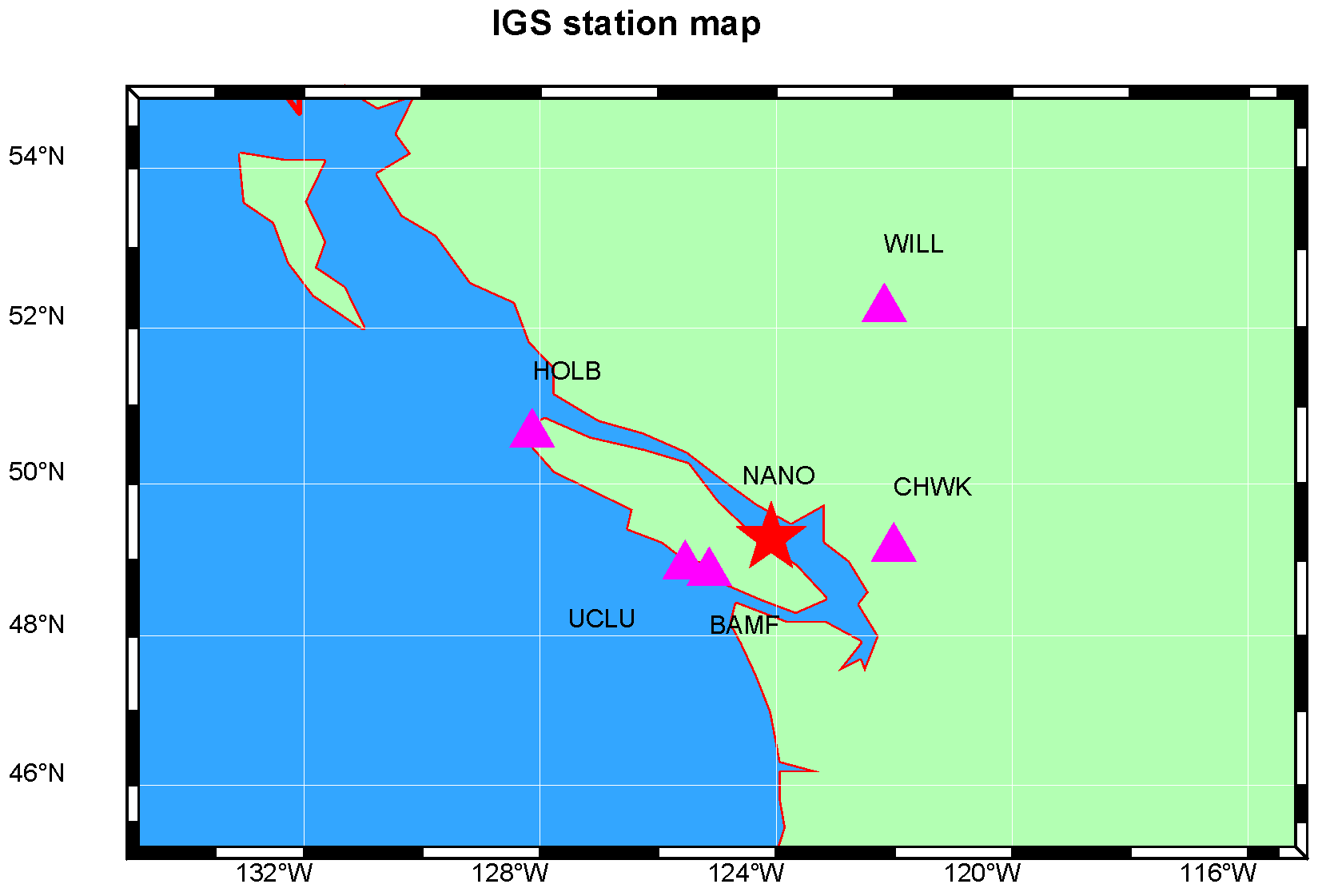
2.1.1. IGS Station Experiment

For the evaluation of the long-baseline RTK positioning performance using the BDS/GPS/Galileo dual-frequency signal combination, data were selected from six stations (NANO, BAMF, UCLU, CHWK, HOLB, and WILL) on 27 January 2024. Five long baselines, each exceeding 90 km in length, were established for the experiment. The observation period was established at 24 h, with the satellite’s cutoff angle of elevation defined as 10°. Figure 1 shows the geographic locations of the studied sites, and Table 1 provides details about the baselines. These International GNSS Service (IGS) stations use SEPT POLARX5 receivers operating at a data sampling rate of 30 s and are designed to capture signals from the BDS, Galileo, and GPS. In real-time dynamic positioning using multi-GNSSs, it is crucial to consider the Inter-System Differential Bias (ISDB). This bias refers to variations in signal measurements between different satellite systems caused by factors such as signal characteristics and receiver design [36,37]. Correcting for these biases is necessary to improve the positioning accuracy during multi-system joint positioning. However, if an identical receiver model is used, such inter-system biases can be deemed negligible, given that their impacts are consistent across all satellite systems. The main data processing configurations are outlined in Table 2.

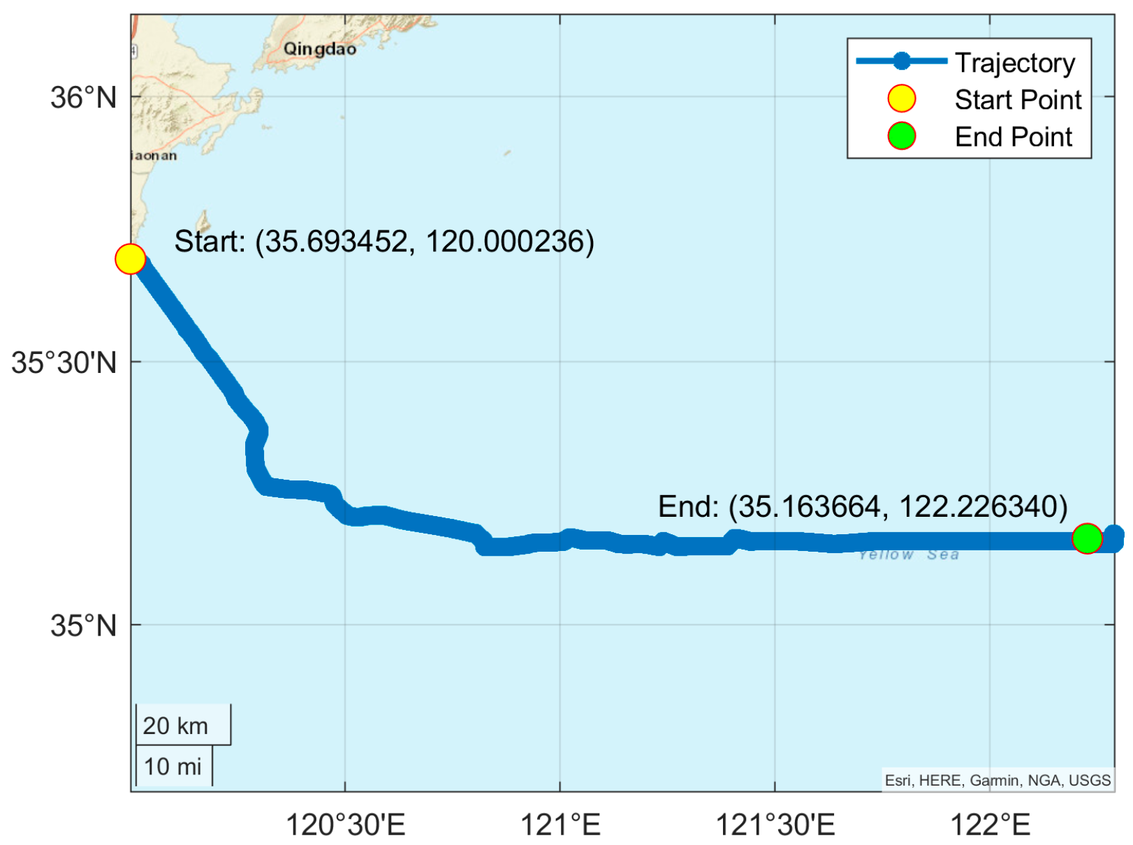
2.1.2. Shipborne Measurement Experiment

To assess the positioning of long-baseline RTK using the dual-frequency signal combination from multi-GNSSs, a dynamic positioning experiment was conducted with shipborne measured data collected on 12 November 2021. Data collection was conducted in Qingdao, using a 1 Hz sampling rate over 12 h. Throughout the experiment, the distance of the baseline separating the test vessel from the shore-based reference station ranged from 6 to 214 km. The test vessel was fitted with a multi-frequency GNSS device designed to capture tracking signals from both the BDS and the GPS. An onshore base station was set up for reference. Figure 2 illustrates the sailing trajectory of the test vessel.

2.2. Long-Baseline Real-Time Kinematic Algorithm Based on Dual-Frequency Signals

2.2.1. Traditional Real-Time Kinematic Model

RTK positioning typically employs double-difference observation equations. Initially, the first difference is determined from the reference station to the rover, and subsequently, the second difference is calculated using signals from various satellites. The proposed approach efficiently reduces the influence of systematic issues, such as discrepancies in satellite and receiver clocks and atmospheric disturbances. The mathematical models for pseudorange and carrier phase double-difference are represented as follows [13]:
Δ P f = Δ ρ + m Δ T + α f Δ I + Δ ε P f Δ Φ f = Δ ρ + m Δ T α f Δ I + λ f Δ N + Δ ε Φ f
In this context, Δ represents the operator used for double difference between stations and satellites. The pseudorange and carrier phases are indicated by P and Φ , respectively. The variable ρ signifies the geometric distance between the satellite and the receiver. The tropospheric projection function is indicated by m , while T denotes the zenith tropospheric delay. The frequency correlation coefficient is represented by α f and I signifies the inclined ionospheric delay. The wavelength λ f corresponds to the frequency f , while N denotes the ambiguity integer. In addition, ε P f and ε Φ f denote the measurement errors related to the pseudorange and carrier phase observations, respectively. This also accounts for additional inaccuracies in the model, including the effects of multipath signals and noise in the measurements.
In applications involving short-baseline RTK (distances less than 10 km), the delays caused by the troposphere and ionosphere in double-difference measurements were sufficiently minor to be regarded as negligible. Therefore, the parameters requiring estimation were restricted to the rover station’s coordinates and the ambiguities related to double difference, which are commonly termed the ionosphere-free model [38,39,40,41]. In long-baseline RTK applications, both the zenith tropospheric and inclined ionospheric delays cannot be effectively removed using the double-difference method. The ionospheric delay must be treated as an undetermined variable using the ionosphere-weighted model [12,40].
After linearizing Equation (1), the observation model is presented as follows:
y = G x R = E ε ε T , E ε = 0
In this context, y denotes the residual after linearization, G represents the design framework, and x refers to the vector of unknown parameters, which incorporates the baseline, tropospheric and ionospheric delays, and integer ambiguity. The variance–covariance structure, R , is determined through the stochastic model based on the elevation angle.
σ = a + b sin E l e σ 0
In this case, σ represents the observation noise, while a and b are scaling factors, generally derived from empirical knowledge and assigned a value of 0.5 in this study. The satellite elevation angle is E l e , while σ 0 stands for the standard deviation of the observed value near the zenith. Typically, the observation noise for pseudorange and carrier phase measurements is approximately 0.3 m and 0.3 cm, respectively.
The Kalman filter is a variance-minimizing technique derived from the optimal estimation principle. This method enables the updating of state parameters by integrating prior estimates with new observation data. Typically, it requires only the storage of state parameter estimates from the previous time step, without the need to retain all historical observation data, thereby offering high computational efficiency. Consequently, the Kalman filter is widely used in real-time data processing. The step-by-step procedure is outlined below:
(1) State Prediction
X k , k 1 = Φ k , k 1 X k 1 P k , k 1 = Φ k , k 1 P k 1 Φ k , k 1 T + Q k 1
(2) Filter Gain
K k = P k , k 1 H k T H k P k , k 1 H k T + R k 1
(3) Measurement Update
X k = X k , k 1 + K k L k H k X k , k 1 P k = I K k H k P k , k 1
where X k , k 1 and P k , k 1 represent the predicted state and its variance for the next step. The state transition matrix between two consecutive time points, t k 1 and t k , is denoted by Φ k , k 1 . X k 1 , P k 1 , and Q k 1 refer to the estimated state, its uncertainty, and the system noise covariance matrix, respectively. K k represents the Kalman gain, H k is the observation matrix, and R k is the measurement noise variance. X k and P k denote the filtered estimate and its uncertainty, respectively. L k represents the observation vector at time t k , while I denotes the identity matrix.
Once the floating ambiguities are adjusted to whole numbers using the Least-Squares Ambiguity Decorrelation Adjustment (LAMBDA) technique, the associated resolved solution and variance–covariance matrix may be updated as follows [42,43]:
b = b ^ Q b ^ a ^ Q a ^ a ^ 1 a ^ a Q b b = Q b ^ a ^ Q b ^ a ^ Q a ^ a ^ 1 Q a ^ b ^
In this case, Q signifies the variance–covariance matrix, while a ^ and a denote the floating and resolved ambiguities, respectively. The symbol b stands for other parameters.
However, as the number of satellites in a multi-GNSS increases, applying the conventional LAMBDA method becomes increasingly complex to resolve all the ambiguity problems. This complexity is especially pronounced in long-baseline RTK scenarios, where the robustness of the model falls short [13,44]. Studies have demonstrated that the PAR method can significantly accelerate convergence and increase the effectiveness of ambiguity resolution in long-baseline RTK scenarios [45,46,47]. This study involved the implementation of a data-driven approach for resolving partial ambiguities, referred to as the two-step success threshold method [48].

2.2.2. Wide Lane Observations

The BDS, GPS, and Galileo satellite navigation systems all provide observation data at more than two frequencies. The corresponding Wide Lane (WL) ambiguity wavelengths for the GPS signals at L1 (1575.42 MHz) and L2 (1227.60 MHz) frequencies, for the BDS signals at B1 (1561.098 MHz) and B2 (1207.140 MHz) frequencies, and for the Galileo signals at E1 (1575.42 MHz) and E5a (1176.45 MHz) frequencies were calculated to be 0.86, 0.85, and 0.75 m, respectively. This result indicates that, although fixing the WL ambiguity is relatively straightforward to achieve, it also increases the ionospheric delay and the amplifying effect of observation noise. WL ambiguity can be resolved with the use of the LAMBDA method. In contrast to the direct ambiguity resolution of first- and second-frequency data, the WL ambiguity resolution is more straightforward, thereby providing valuable support for resolving the ambiguity resolution in the original first- and second-frequency data. Unlike the resolution of Extra-Wide-Lane (EWL) ambiguities, using a simple rounding method to address WL ambiguity is risky due to the noise present in pseudorange measurements. Consequently, WL ambiguity resolution usually uses geometric methods. The model for this resolution can be formulated as follows:
V P 1 V P 2 V W L = B 0 B 0 B I X N W L
In this context, V signifies the pre-fitting residual of the observation vector; B refers to the geometric vector related to the reference coordinates, X ; and I indicates the unit vector associated with the WL ambiguity, N W L .
It is essential to mention that the ionospheric delay effect was excluded after the double difference in the equation above. The influence of the ionosphere on the WL ambiguity resolution is considered minimal for baselines established at a specific cutoff elevation angle. Its impact on the findings is discussed in the following section.
Once the ambiguity of the WL data is addressed, the corresponding observations are reclassified as pseudorange measurements, with noise levels much lower than those of the original pseudorange data. Consequently, the original long-baseline RTK positioning model, augmented by the WL, is represented in the following form:
V P 1 V P 2 V L 1 V L 2 V W L f i x = B 0 0 m I B 0 0 m f 1 2 f 2 2 I B I 0 m I B 0 I m f 1 2 f 2 2 I B 0 0 m f 1 f 2 I X N L 1 N L 2 T r o p I o n
where W L f i x indicates the WL signal following the resolution of ambiguity, m represents the tropospheric mapping function, and T r o p and I o n correspond to the zenith calculated tropospheric and inclined ionospheric delays, respectively.

2.2.3. Adjustments for Tropospheric and Ionospheric Effects

In long-baseline RTK, in addition to site coordinates and ambiguities, additional parameters, such as the troposphere and ionosphere, must be estimated. The inclusion of these additional parameters increases the correlation between the different types of parameters, which in turn prolongs the time required for the ADOP to converge to a level sufficient for ensuring positioning accuracy [13,49]. In the aforementioned equation, the double-difference troposphere and ionosphere are estimated concurrently with the site coordinates and ambiguity parameters. The ambiguity robustness is improved by applying suitable restrictions to the ionospheric adjustment model for long-baseline RTK, thereby enabling faster convergence. Subsequently, the ambiguity parameters can be refined through the Kalman filter.
An accuracy level of 5 cm was achieved by the latest global models for tropospheric delay, including the Global Pressure and Temperature 2 wet (GPT2w) [50]. Because tropospheric delays from different epochs vary within a certain range, this indicates that residual tropospheric delays may be represented as stochastic process parameters and estimated using the Kalman filter, thereby improving the accuracy and consistency of tropospheric delay estimations.
The vertical variation in ionospheric delay is generally in the range of 2-50 ppm, influenced by geographic location and the levels of solar radiation [51,52]. This estimates the inclined ionospheric delay, accounting for the impacts of the distance between stations and geographic position, and the correlation with the cutoff angle of elevation, which is crucial when modeling ionospheric constraints and stochastic noise.

2.2.4. Dual-Frequency Long-Baseline Real-Time Kinematic

To summarize this section, Figure 3 illustrates the process of dual-frequency long-baseline RTK. The processing flow for dual-frequency long-baseline RTK typically involves the following steps:
1. First, WL observations based on geometry can be used to construct the WL normal equation.
2. By setting an appropriate cutoff elevation angle and applying a PAR strategy, the WL ambiguity can be resolved.
3. Once the WL ambiguity is resolved, it can be reclassified as pseudorange measurements and merged with the original dual-frequency pseudorange and carrier phase measurements.
4. Upon executing the PAR strategy, a fixed solution is achieved if successful. If the ambiguity resolution is unsuccessful, the result is a floating solution.

3. Results

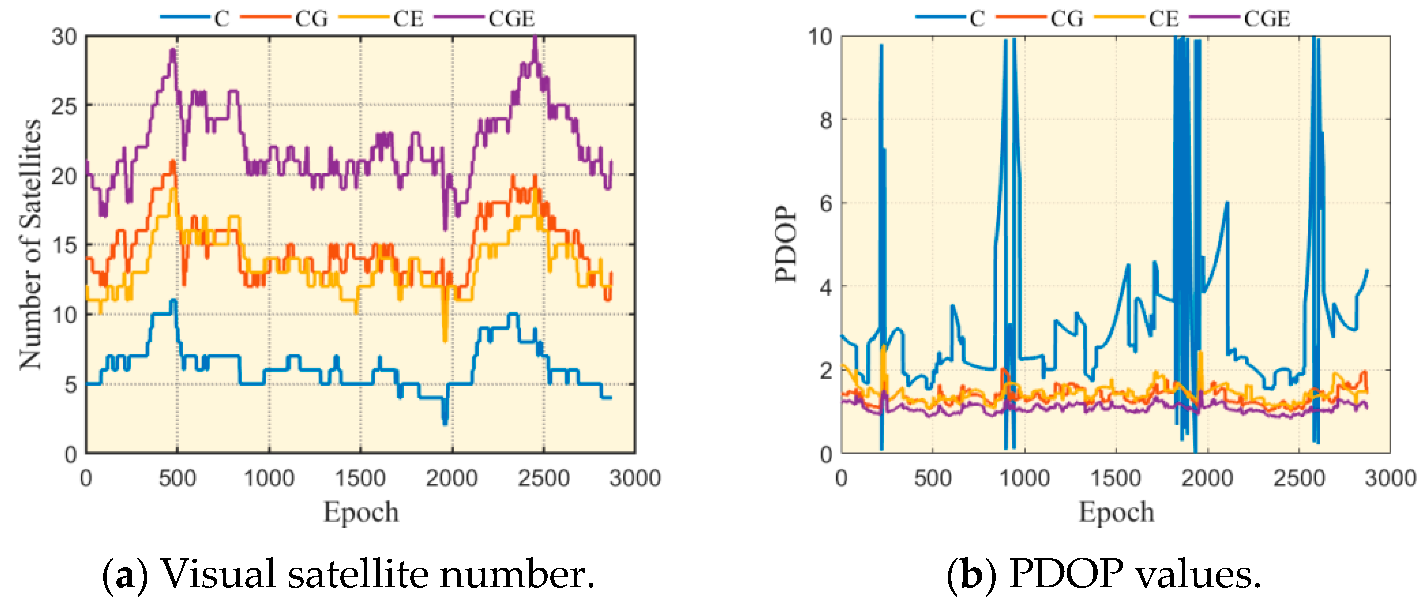
3.1. Factors Affecting the Positioning Performance of Long-Baseline RTK Systems

In this section, we analyze the effects of broadcast ephemeris, tropospheric, and ionospheric errors on long-baseline RTK to gain a comprehensive understanding of the differences between short and long baseline RTK.

3.1.1. Broadcast Ephemeris Error

In long-baseline RTK post-processing applications, rapid or ultra-rapid precise ephemeris data are used to reduce the impact of satellite orbit and clock errors on the positioning results. For users needing real-time processing, accessing satellite broadcast data is a more practical option because it does not depend on real-time correction streams for orbit and clock information. Consequently, examining the impact of satellite broadcast data on long-baseline RTK applications becomes important. In this study, two baselines measuring 92 and 354 km were specifically analyzed, and the positioning results were compared using the final satellite orbit and clock data products obtained from Wuhan University (WHU). The positioning errors of various systems are shown in Figure 4.
The positioning accuracy of long-baseline RTK is evaluated by calculating the root mean square (RMS) of the errors, which is defined as follows:
R M S = 1 n i = 1 n d i d ¯ 2
where d i is the difference of the i -th point, d ¯ is the average of all differences, and n is the total number of differences.
As illustrated in Figure 4a, for a 92 km baseline, the RMS errors associated with the BDS due to the broadcast ephemeris are 0.091 for the North (N), 0.154 for the East (E), and 0.080 m for the Up (U) components. For GPS, the corresponding errors were 0.010, 0.011, and 0.013 m, while for Galileo, the values were 0.020, 0.030, and 0.021 m. Figure 4b illustrates that, with a 354 km baseline, the positioning RMS errors in the BDS, which can be attributed to the broadcast ephemeris, are 0.080, 0.136, and 0.077 m in the North (N), East (E), and Up (U) directions, respectively. The GPS errors were 0.014, 0.028, and 0.078 m, while the Galileo errors were 0.034, 0.062, and 0.072 m. The low data quality from the satellites (BDS) caused significant disruption during the observation period, whereas the positioning errors for GPS and Galileo were maintained within the centimeter level. However, ephemeris errors are deemed acceptable for real-time applications, and broadcast ephemeris were employed in this study.

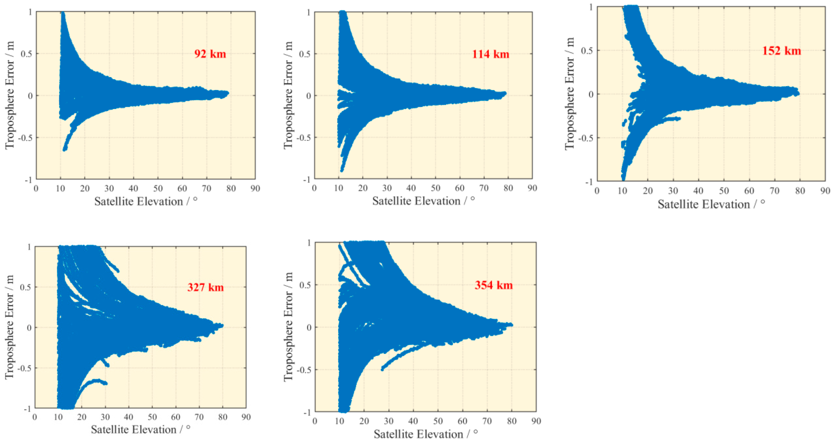
3.1.2. Tropospheric Error

The zenith tropospheric delay error can be modified by employing an accurate tropospheric model. When RTK operations are conducted within a certain distance, the error is relatively small due to the spatial correlation of tropospheric delay. However, when this delay is projected onto an oblique path, especially for satellites positioned at low elevation angles, the error can increase significantly. In the case of PPP floating solutions, this effect can be reduced by applying suitable weights to observations. However, in RTK integer solutions, inclined tropospheric errors can affect the effectiveness of the ambiguity resolution. Utilizing the daily solutions for station coordinates from the IGS and applying the precise orbit products, we can accurately estimate the double-difference tropospheric errors. Figure 5 shows the correlation between the inclined tropospheric error and the satellite elevation angle at various baseline lengths.
As the satellite elevation angle decreased, the tropospheric error increased significantly due to the influence of the tropospheric mapping factor. Furthermore, the tropospheric error also increased with increasing baseline length, primarily because the spatial correlation of the troposphere diminished with distance. The findings reveal that the tropospheric error is effectively assessed using the random walk framework. For baselines extending up to 200 km, the tropospheric effect becomes insignificant in the WL ambiguity resolution when the satellite’s elevation angle exceeds 40°.

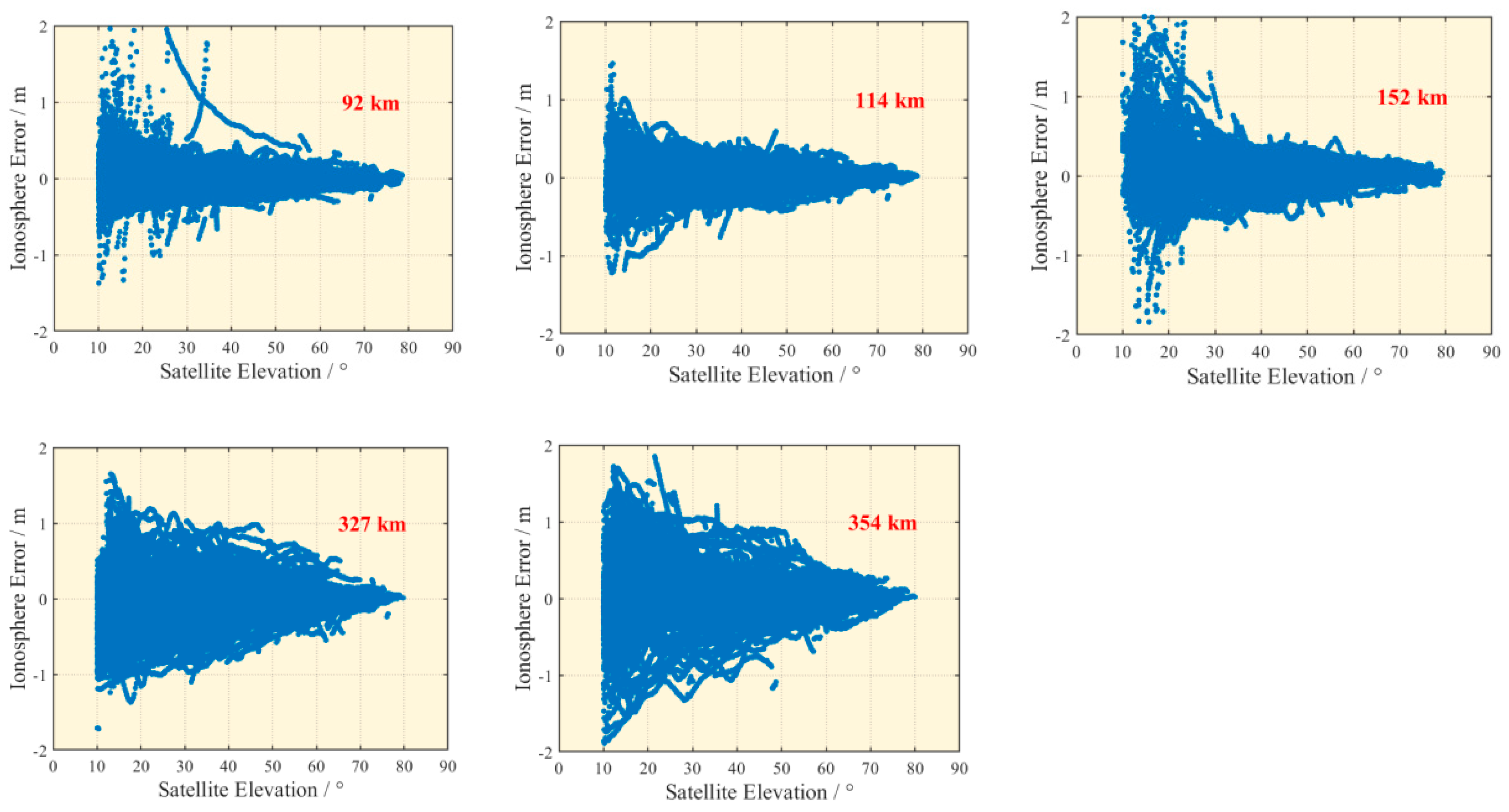
3.1.3. Ionospheric Error

In long-baseline RTK, the ionospheric delay error is a more pronounced magnitude of the errors than the tropospheric delay [41,46]. Upon correcting for tropospheric variations and fixing the reference station coordinates, we can derive the double-difference ionospheric errors and resolve the ambiguities. Figure 6 illustrates how the ionospheric error changes with the satellite angle of elevation across various baseline lengths.
The correlation between ionospheric errors and satellite angle of elevation is evident, with the magnitude of errors varying across different baseline lengths. For a 92 km baseline, ionospheric errors are confined to 0.5 m, while for a 354 km baseline, errors may exceed 1 m. Consequently, when employing the ionosphere-fixed model for data processing, users should establish an appropriate cutoff elevation angle to enhance positioning accuracy.

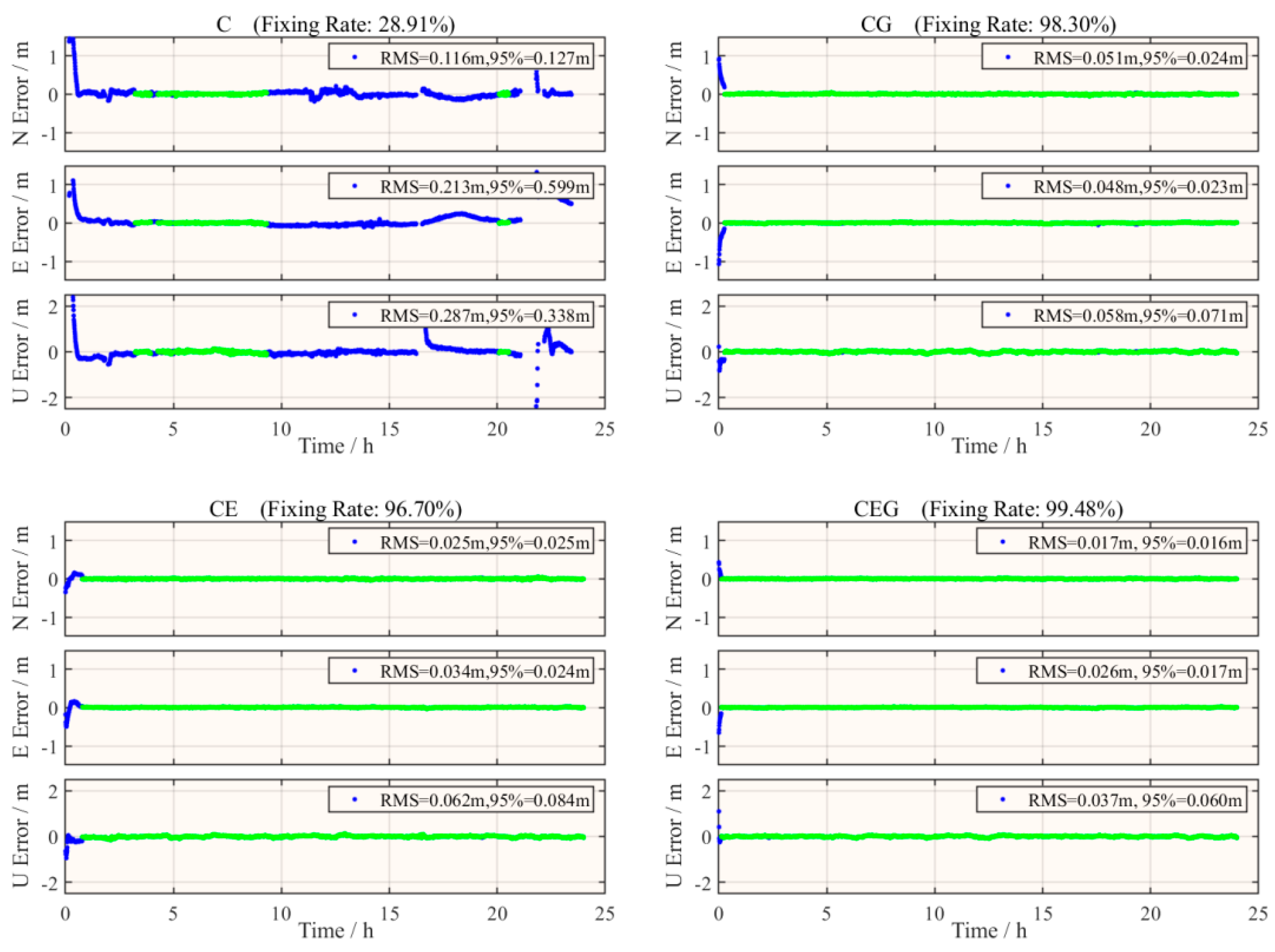
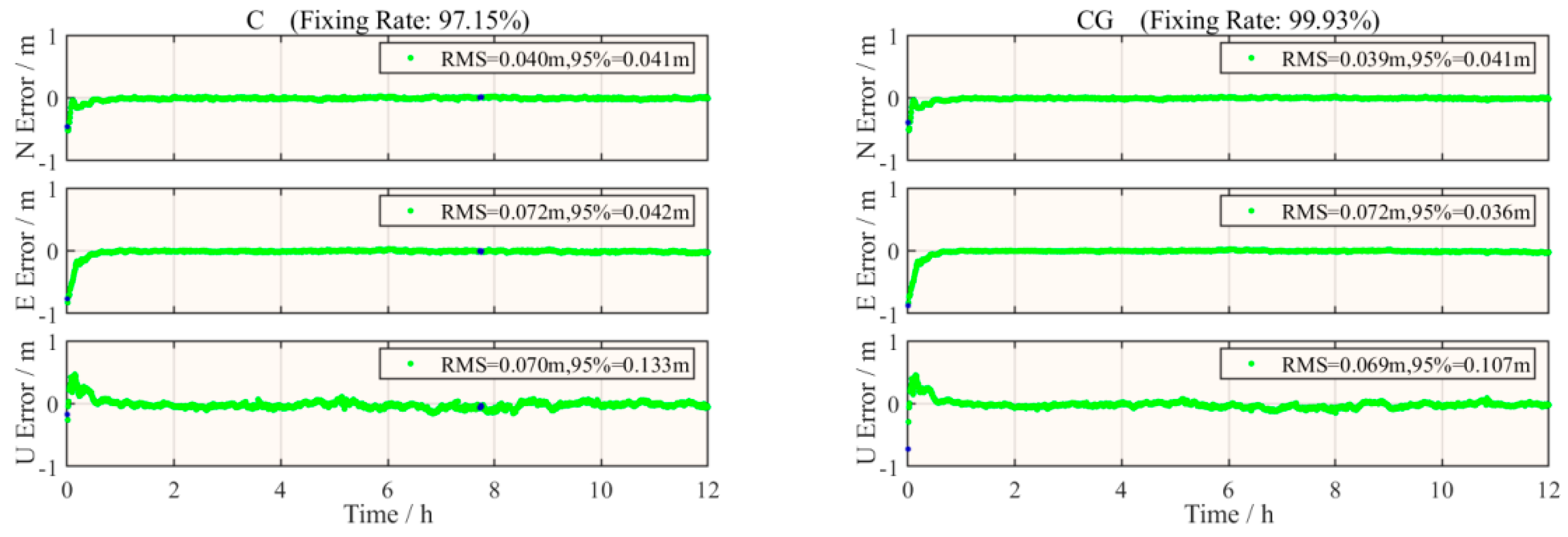
3.2. Evaluation of RTK Positioning Performance for Different Baseline Lengths

Section 3.1 showed that, in long-baseline RTK, it is crucial to assess tropospheric and ionospheric errors as important parameters. This section analyzes the performance of dual-frequency long-baseline RTK using the algorithm outlined in Section 2.2, with data from five sets of IGS stations and one set of shipborne measured measurements.

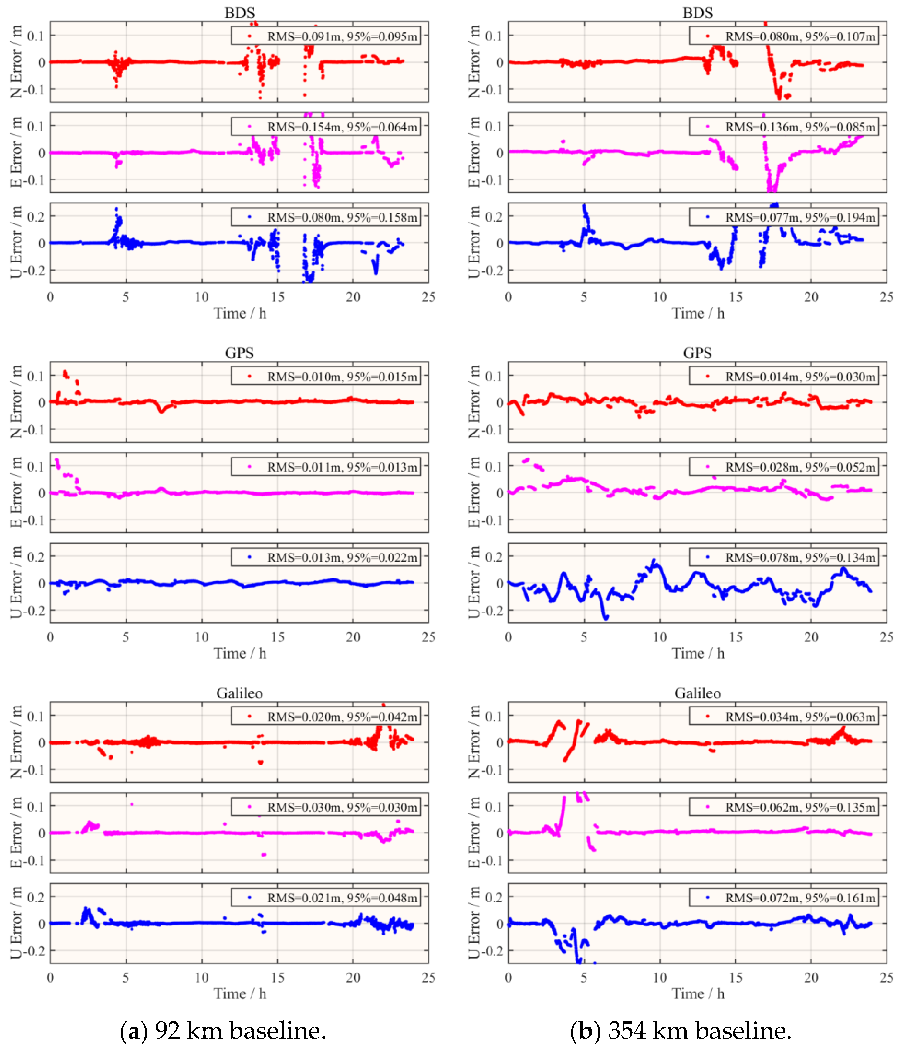
3.2.1. IGS Station Experiment

In the multi-GNSS RTK analysis, the number of satellites and their spatial configuration are crucial factors that greatly affect positioning accuracy. To highlight the influence of multi-GNSSs on the positioning model, Figure 7 illustrates the variations in the satellite visibility and Position Dilution of Precision (PDOP) values using observations from the NANO base station.
The single BDS had an average of 6.3 satellites when data were collected. By combining BDS, GPS, and Galileo, the average satellite count rose to 14.9 and 13.7. When all three systems are integrated, the number of detectable satellites can reach an average of 22.2. Generally, the satellite coverage across all system combinations is adequate to fulfill positioning requirements. An average PDOP of 3.08 is observed for the BDS alone, improving to 1.37 and 1.45 when integrated with GPS and Galileo, respectively. In the BDS, GPS, and Galileo system integration, the improvement in the PDOP value further decreases to 1.08. Figure 5 illustrates that, when the GPS is integrated with Galileo, the fluctuations in PDOP values become smoother, indicating that the integration of multi-GNSSs significantly improves positioning accuracy and stability. Such improvements are of great practical significance, particularly for areas with a complex terrain that require high-precision positioning services.
Based on the algorithm described in Section 2.2, this study conducted RTK positioning experiments on five baselines. During the RTK positioning process of the multi-GNSS, this study employed the loose combination model to resolve ambiguities, where each GNSS is treated as an independent entity. This study uses a continuous ambiguity resolution mode in the Kalman filtering process. When cycle slip is absent and the satellite angle of elevation exceeds the preset cutoff angle, the ambiguity parameter takes on a constant value [16]. To achieve reliable fixed solutions in real-time dynamic positioning, the minimum success rate threshold for PAR was set to 0.99 [43]. Furthermore, to account for potential weaknesses within the model, the limit value is established at 2.0 [44]. To minimize the noise effects from low satellite elevation, the cutoff angle of elevation is established at 20° during the ambiguity resolution process. As discussed in Section 3.1, the cutoff angle is established at 40° for the resolution of WL ambiguity.
The effectiveness of long-baseline RTK is assessed by defining the ambiguity resolution fixing rate as follows:
f i x i n g   r a t e = n f i x n
In this context, n f i x denotes the accurate count of ambiguities, and n represents the total count of ambiguities across all epochs. Correct ambiguity fixing occurs when, during a specific epoch, the ratio exceeds 2, and the positioning deviation remains below 20 cm.
The RTK positioning results over 24 h are summarized in Figure 8, which includes the North, East, and Up positioning error components, along with the ambiguity fixing rate. Figure 9 demonstrates the capability of RTK-based positioning for an individual BDS satellite and its combined performance with other GNSS, using a 152 km baseline for illustration.
As shown in Figure 8 and Figure 9, the accuracy and fixing rate of RTK positioning decrease slightly as the baseline length increases. Across the evaluated GNSS configurations, the long-baseline RTK positioning performance of an individual BDS was comparatively weak. However, when BDS is integrated with other GNSSs, both positioning accuracy and fixing rate are significantly improved. In a multi-GNSS configuration, the positioning RMS errors are approximately 3 cm horizontally and 6 cm vertically. Generally, fixing rates remain above 95%, with floating solutions primarily occurring during the positioning convergence phase. In long-baseline RTK, insufficient model robustness can lead to fixing errors in LAMBDA algorithms, particularly when using a data-driven PAR strategy [44], as shown in Figure 9.

3.2.2. Shipborne Measurement Experiment

This study uses the RT-PPP coordinates from the global PPP service StarFire as the reference for the navigation trajectory. The measured data are processed using both single BDS data and combined BDS/GPS dual-system data. By comparing the positioning results from these solutions with the reference truth, the derived positioning error sequences are presented in Figure 10. Table 3 presents the positioning errors expressed in RMS values and the success rate for resolving ambiguity.
As shown in Figure 10 and Table 3, the ambiguity fixing rate is 97.15% when using only BDS data. However, the occurrence of certain errors in resolving ambiguities suggests that the consistency of the proposed scheme can be improved. In contrast, the combined BDS and GPS exhibits a high ambiguity fixing rate of 99.93%, approximately 100%, with no fixed errors detected, indicating a more stable and reliable scheme. Using the combined system, the positioning accuracy of both the plane and height can be maintained within 8 cm and 7 cm, respectively. In addition, the positioning error demonstrates satisfactory stability over time. The results above suggest that, in maritime surveying applications, the multi-system combination improves ambiguity resolution and offers a better positioning performance compared to a single system. Figure 11 illustrates the fixed ambiguity quantities and ratio values for each epoch in the multi-system solution process, where a ratio value of zero indicates that the epoch has not achieved a fixed solution.
Figure 11 reveals that the average number of resolved ambiguities in the BDS and GPS combination system is 25.9, surpassing the 23.7 recorded for the BDS-only system. Furthermore, the average ratio of the combined BDS and GPS was 8.5, while the single BDS had an average ratio of 6.3. These results reveal that the combined system demonstrates enhanced consistency compared to using only one system.

4. Discussion

Besides the above analysis, there are several interesting topics that are discussed in this section.

4.1. Is the Approach of Treating Atmospheric Delays as Unknown Parameters the Only Feasible Solution?

Treating atmospheric delays as unknown parameters may weaken the mathematical model and increase the observation time required to estimate the correct ambiguities. However, we do not consider our approach to be the only possible one. Here are some alternative approaches and why we believe our chosen method remains advantageous:
1. Use of External Ionospheric Models: While we acknowledge that incorporating external ionospheric models can improve the estimation process, the accuracy and timeliness of such models can vary significantly, especially in regions with limited monitoring infrastructure. Our approach aims to be more universally applicable and less dependent on external data sources.
2. Kalman Filter with A Priori Constraints: Using a priori constraints can strengthen the model. However, this requires reliable and up-to-date a priori information, which may not always be available, especially in dynamic environments or for less-studied regions. Our method aims to provide a robust solution even in the absence of such information.
3. Machine Learning Approaches: Advanced machine learning techniques could potentially predict atmospheric delays. However, these methods often require extensive training datasets and are not always suitable for real-time applications due to their computational complexity. Our approach prioritizes real-time performance and computational efficiency.
While we recognize that there are multiple ways to address the issue of atmospheric delays in long-baseline RTK positioning, we believe that our approach offers a practical and effective solution, particularly for real-time applications where computational efficiency and universal applicability are crucial. We are, however, open to exploring and incorporating additional methods that can further improve the robustness and accuracy of our model.

4.2. Are There Any Potential Negative Aspects or Disadvantages Associated with the Integration of Multiple GNSSs?

While the focus has been on the positive aspects of integrating multiple GNSSs, such as improved accuracy, availability, and reliability, it is also important to acknowledge the potential negative aspects. One significant issue is the increased computational burden. With multiple systems involved, there is a need to handle different data formats, signal frequencies, and satellite ephemeris information. This requires more sophisticated software and hardware setups to ensure seamless integration and accurate processing. Additionally, in some cases, interference between the signals of different GNSSs can occur, especially in environments with high levels of radio-frequency interference. This interference can potentially degrade the quality of the collected data and introduce errors in the positioning results.

4.3. To What Extent Must a Subset of Ambiguities Be Fixed for the Partial Ambiguity Resolution (PAR) Technique to Be More Efficient than Full Ambiguity Resolution (FAR)?

Taking the BDS/GPS/Galileo combined system in the IGS Station Experiment as an example, we compiled the results for 2880 epochs for the day, as shown in Table 4. For the shortest ‘NANO-BAMF’ baseline of 92 km, PAR requires fixing 94.6% of the full ambiguity set; whereas for the longest ‘NANO-WILL’ baseline of 354 km, PAR only needs to fix 69.3% of the full ambiguity set. It is evident that, as the baseline length increases, the ratio of the subset size fixed by PAR to the full set size fixed by FAR decreases, highlighting the advantage of PAR in long-baseline applications. In addition, as can be seen from Table 4, PAR not only shows higher percentage increases in accuracy, but also improves the number of fixed epochs and the fixing rate. The specific percentages can vary depending on the environment and the assistance technology used, which can further enhance the performance of PAR.

5. Conclusions

This research employed Kalman filtering and partial ambiguity resolution to evaluate the long-baseline real-time kinematic positioning performance of the combined BDS, GPS, and Galileo systems.
Our findings indicate that, for users engaged in real-time applications, the influence of broadcast ephemeris errors is negligible, while tropospheric and ionospheric errors should be modeled as random walk parameters within the Kalman filter.
Through long-baseline RTK positioning experiments using BDS/GPS/Galileo data across various baseline lengths, we demonstrated that multi-GNSSs can enhance the positioning performance of long-baseline RTK. Further validation with medium–long baseline shipborne data confirmed that the multi-GNSS can effectively improve the process of resolving ambiguities.
Due to temporal and spatial variability and factors such as ionospheric errors, it is recommended to gather additional data and conduct a thorough analysis to better understand the impact of multi-GNSSs on long-baseline RTK. However, the findings of this study have effectively shown the significant role that GNSSs play in RTK localization. Future work will focus on investigating long-baseline positioning methods in maritime survey scenarios and integrating low-cost inertial components to explore dynamic integrated navigation algorithms in complex marine environments.

Author Contributions

Conceptualization, D.Y. and Y.L.; methodology, Y.L.; software, D.Y.; validation, K.J.; formal analysis, S.W.; investigation, Z.W.; resources, K.J.; data curation, C.Z.; writing—original draft preparation, D.Y.; writing—review and editing, S.W.; visualization, C.Z.; supervision, Z.W.; project administration, H.L.; funding acquisition, H.L., Z.W., S.W. and Y.L. All authors have read and agreed to the published version of the manuscript.

Funding

This research was funded by the National Science Foundation for Outstanding Young Scholars, grant number 42122025, the Independent Research Project of Naval Engineering University, grant number 2023509100, the National Natural Science Foundation of China, grant number 42404017, and Hubei Provincial Department of Education Science and Technology Plan Project, grant number Q20231602.

Data Availability Statement

The original data presented in the study are openly available in http://www.igs.gnsswhu.cn (accessed on 24 May 2024).

Conflicts of Interest

The authors declare no conflicts of interest.

References

  1. Chen, X.; Liu, H.; Yu, B.; Sheng, C.; Huang, G.; Hui, S.; Ying, J. BeiDou/GNSS wide-area precise positioning technology and service: Current situation and prospects. Geomat. Inf. Sci. Wuhan Univ. 2024. [Google Scholar] [CrossRef]
  2. Tang, W.; Zhang, S.; Deng, C.; Qi, K.; Nie, X.; Zou, X.; Li, Y. Analysis and evaluation of network real-time kinematic positioning performance based on standalone BDS receivers. Geomat. Inf. Sci. Wuhan Univ. 2024. [Google Scholar] [CrossRef]
  3. Shi, C.; Gu, S.; Lou, Y.; Zheng, F.; Song, W.; Zhang, D.; Mao, F. Real-time wide-area precise positioning and precise timing service system. Acta Geod. Cartogr. Sin. 2022, 51, 1206–1214. [Google Scholar]
  4. Remondi, B.W. Performing centimeter-level surveys in seconds with GPS carrier phase: Initial results. Navigation 1985, 32, 386–400. [Google Scholar] [CrossRef]
  5. Edwards, S.J.; Cross, P.A.; Barnes, J.B.; Bétaille, D. A methodology for benchmarking real time kinematic GPS. Surv. Rev. 1999, 35, 163–174. [Google Scholar] [CrossRef]
  6. Li, B.; Miao, W.; Chen, G. Key technologies and challenges of multi-frequency and multi-GNSS high-precision positioning. Geomat. Inf. Sci. Wuhan Univ. 2023, 48, 1769–1783. [Google Scholar]
  7. Song, W.; Mao, W.; Zhang, Y. Achievements and opportunities in the development of GNSS RTK positioning technology. World Sci-Tech R D 2023, 45, 294–305. [Google Scholar]
  8. Gao, W.; Pan, S.; Huang, G. Medium-baseline RTK positioning method based on BDS-3 and Galileo multi-frequency ionosphere-reduced combinations. J. Chin. Inert. Technol. 2020, 28, 783–788. [Google Scholar]
  9. Pirti, A.; Gümüş, K.; Erkaya, H.; Hoşbaş, R.G. Evaluating repeatability of RTK GPS/GLONASS near/under forest environment. Croat. J. For. Eng. J. Theory Appl. For. Eng. 2010, 31, 23–33. [Google Scholar]
  10. He, H.; Li, J.; Yang, Y.; Xu, J.; Guo, H.; Wang, A. Performance assessment of single-and dual-frequency BeiDou/GPS single-epoch kinematic positioning. GPS Solut. 2014, 18, 393–403. [Google Scholar] [CrossRef]
  11. Wang, L.; Li, Z.; Yuan, H.; Zhou, K. Validation and analysis of the performance of dual-frequency single-epoch BDS/GPS/GLONASS relative positioning. Chin. Sci. Bull. 2015, 60, 857–868. [Google Scholar] [CrossRef]
  12. Zhang, Y.; Kubo, N.; Chen, J.; Chu, F.Y.; Wang, H.; Wang, J. Contribution of QZSS with four satellites to multi-GNSS long baseline RTK. J. Spat. Sci. 2020, 65, 41–60. [Google Scholar] [CrossRef]
  13. Odolinski, R.; Teunissen, P.J.G.; Odijk, D. Combined GPS+BDS for short to long baseline RTK positioning. Meas. Sci. Technol. 2015, 26, 045801. [Google Scholar] [CrossRef]
  14. Odolinski, R.; Teunissen, P.J.G.; Odijk, D. Combined GPS+BDS+Galileo+QZSS for Long Baseline RTK Positioning. In Proceedings of the 27th International Technical Meeting of the Satellite Division of The Institute of Navigation (ION GNSS+ 2014), Tampa, FL, USA, 8–12 September 2014. [Google Scholar]
  15. Li, B.; Feng, Y.; Shen, Y. Three carrier ambiguity resolution: Distance-independent performance demonstrated using semi-generated triple frequency GPS signals. GPS Solut. 2010, 14, 177–184. [Google Scholar] [CrossRef]
  16. Takasu, T.; Yasuda, A. Kalman-filter-based integer ambiguity resolution strategy for long-baseline RTK with ionosphere and troposphere estimation. In Proceedings of the 23rd International Technical Meeting of the Satellite Division of the Institute of Navigation (ION GNSS 2010), Portland, OR, USA, 21–24 September 2010. [Google Scholar]
  17. Bramanto, B.; Gumilar, I.; Taufik, M.; Hermawan, I.M.D.A. Long-range single baseline RTK GNSS positioning for land cadastral survey map. E3S Web Conf. 2019, 94, 1022. [Google Scholar] [CrossRef]
  18. Zhang, W.; Wang, J.; Khodabandeh, A. Regional ionospheric correction generation for GNSS PPP-RTK: Theoretical analyses and a new interpolation method. GPS Solut. 2024, 28, 139. [Google Scholar] [CrossRef]
  19. Yin, X.; Chai, H.; El-Mowafy, A.; Zhang, Y.; Zhang, Y.; Du, Z. Modeling and assessment of atmospheric delay for GPS/Galileo/BDS PPP-RTK in regional-scale. Measurement 2022, 194, 111043. [Google Scholar] [CrossRef]
  20. Gao, R.; Ye, F.; Odolinski, R.; Satirapod, C.; Zhang, B. Mitigating ionospheric scintillation effects on RTK-based long-span bridge deformation monitoring. Measurement 2025, 242, 115957. [Google Scholar] [CrossRef]
  21. Kubo, Y.; Tanaka, H.; Ohashi, M.; Sugimoto, S. Long baseline GNSS relative positioning with estimating ionospheric and tropospheric delays and their gradients. In Proceedings of the 42th ISCIE International Symposium on Stochastic Systems Theory and its Applications, Okayama, Japan, 26–27 November 2011. [Google Scholar]
  22. Zhang, Y.; Zhang, X.; Liu, Q.; Zhu, F. A method of dynamic positioning with the medium and long baseline for aerial measurement scenarios. Acta Geod. Cartogr. Sin. 2019, 48, 871–878. [Google Scholar]
  23. Shu, B.; Liu, H.; Xu, L.; Qian, C.; Gong, X.; An, X. Performance analysis of BDS medium-long baseline RTK positioning using an empirical troposphere model. Sensors 2018, 18, 1199. [Google Scholar] [CrossRef]
  24. Hou, P.; Zhang, B.; Liu, T. Integer-estimable GLONASS FDMA model as applied to Kalman-filter-based short-to long-baseline RTK positioning. GPS Solut. 2020, 24, 93. [Google Scholar] [CrossRef]
  25. Choi, B.K.; Roh, K.M.; Lee, S.J. Long baseline GPS RTK with estimating tropospheric delays. J. Position. Navig. Timing 2014, 3, 123–129. [Google Scholar] [CrossRef]
  26. Xu, Y.; Wu, C.; Li, L.; Yan, L.; Liu, M.; Wang, S. GPS/BDS medium/long-range RTK constrained with tropospheric delay parameters from NWP model. Remote Sens. 2018, 10, 1113. [Google Scholar] [CrossRef]
  27. Shu, B.; Liu, H.; Zhang, J.; Pan, G.; Jiang, J. Performance assessment of partial ambiguity resolution based on BDS/GPS combined positioning. Geomat. Inf. Sci. Wuhan Univ. 2017, 42, 989–994+1001. [Google Scholar]
  28. Teunissen, P.J.G.; Joosten, P.; Tiberius, C. Geometry-free ambiguity success rates in case of partial fixing. In Proceedings of the 1999 National Technical Meeting of the Institute of Navigation, San Diego, CA, USA, 25–27 January 1999. [Google Scholar]
  29. Dai, L.L.; Eslinger, D.J.; Sharpe, R.T.; Hatch, R.R. Partial Search Carrier-Phase Integer Ambiguity Resolution. U.S. Patent 7,961,143, 14 June 2011. [Google Scholar]
  30. Vollath, U.; Doucet, K.D. GNSS Signal Processing with Partial Fixing of Ambiguities. U.S. Patent 7,538,721, 26 May 2009. [Google Scholar]
  31. Teunissen, P.J.G.; Verhagen, S. The GNSS ambiguity ratio-test revisited: A better way of using it. Surv. Rev. 2009, 41, 138–151. [Google Scholar] [CrossRef]
  32. Hou, Y.; Verhagen, S. Model and data driven partial ambiguity resolution for multi-constellation GNSS. In Proceedings of the 5th China Satellite Navigation Conference (CSNC 2014) Proceedings, Nanjing, China, 21 May 2014. [Google Scholar]
  33. Lu, L.; Ma, L.; Liu, W.; Wu, T.; Chen, B. A triple checked partial ambiguity resolution for GPS/BDS RTK positioning. Sensors 2019, 19, 5034. [Google Scholar] [CrossRef]
  34. Chu, F.Y.; Yang, M. GPS/Galileo long baseline computation: Method and performance analyses. GPS Solut. 2014, 18, 263–272. [Google Scholar] [CrossRef]
  35. Li, G.; Wu, J.; Zhao, C.; Tian, Y. Double differencing within GNSS constellations. GPS Solut. 2017, 21, 1161–1177. [Google Scholar] [CrossRef]
  36. Odijk, D.; Teunissen, P.J.G. Estimation of differential inter-system biases between the overlapping frequencies of GPS, Galileo, BeiDou and QZSS. In Proceedings of the 4th International Colloquium Scientific and Fundamental Aspects of the Galileo Programme, Prague, CZ, USA, 4–6 December 2013. [Google Scholar]
  37. Odijk, D.; Nadarajah, N.; Zaminpardaz, S.; Teunissen, P.J.G. GPS, Galileo, QZSS and IRNSS differential ISBs: Estimation and application. GPS Solut. 2017, 21, 439–450. [Google Scholar] [CrossRef]
  38. Ge, M.; Gendt, G.; Rothacher, M.; Shi, C.; Liu, J. Resolution of GPS carrier-phase ambiguities in precise point positioning (PPP) with daily observations. J. Geod. 2008, 82, 389–399. [Google Scholar] [CrossRef]
  39. Katsigianni, G.; Loyer, S.; Perosanz, F. PPP and PPP-AR kinematic post-processed performance of GPS-only, Galileo-only and multi-GNSS. Remote Sens. 2019, 11, 2477. [Google Scholar] [CrossRef]
  40. Odijk, D. Weighting ionospheric corrections to improve fast GPS positioning over medium distances. In Proceedings of the 13th International Technical Meeting of the Satellite Division of the Institute of Navigation (ION GPS 2000), Salt Lake City, UT, USA, 19–22 September 2000. [Google Scholar]
  41. Teunissen, P. Springer Handbook of Global Navigation Satellite Systems; Springer International Publishing: Cham, Switzerland, 2017. [Google Scholar]
  42. Teunnissen, P.J.G. The least-square ambiguity decorrelation adjustment: A method for fast GPS integer ambiguity estimation. J. Geod. 1995, 70, 65–82. [Google Scholar] [CrossRef]
  43. Verhagen, S.; Li, B.; Geodesy, M. LAMBDA Software Package: Matlab Implementation, version 3.0; Delft University of Technology and Curtin University: Perth, Australia, 2012.
  44. Verhagen, S.; Teunissen, P.J.G. The ratio test for future GNSS ambiguity resolution. GPS Solut. 2013, 17, 535–548. [Google Scholar] [CrossRef]
  45. Parkins, A. Increasing GNSS RTK availability with a new single-epoch batch partial ambiguity resolution algorithm. GPS Solut. 2011, 15, 391–402. [Google Scholar] [CrossRef]
  46. Gao, W.; Gao, C.; Pan, S.; Wang, D.; Deng, J. Improving ambiguity resolution for medium baselines using combined GPS and BDS dual/triple-frequency observations. Sensors 2015, 15, 27525–27542. [Google Scholar] [CrossRef]
  47. Zhang, S.; Zhao, L.; Li, X.; Cheng, B. A sequential and partial ambiguity resolution strategy for improving the initialization performance of medium-baseline relative positioning. Earth Planets Space 2016, 68, 1–10. [Google Scholar] [CrossRef]
  48. Hou, Y.; Verhagen, S.; Wu, J. A data driven partial ambiguity resolution: Two step success rate criterion, and its simulation demonstration. Adv. Space Res. 2016, 58, 2435–2452. [Google Scholar] [CrossRef]
  49. Odijk, D.; Teunissen, P.J.G. ADOP in closed form for a hierarchy of multi-frequency single-baseline GNSS models. J. Geod. 2008, 82, 473–492. [Google Scholar] [CrossRef]
  50. Böhm, J.; Möller, G.; Schindelegger, M.; Pain, G.; Weber, R. Development of an improved empirical model for slant delays in the troposphere (GPT2w). GPS Solut. 2015, 19, 433–441. [Google Scholar] [CrossRef]
  51. Wanninger, L. Effects of the equatorial ionosphere on. GPS World 1993, 48–54. [Google Scholar]
  52. Foster, J.C. Quantitative investigation of ionospheric density gradients at mid latitudes. In Proceedings of the 2000 National Technical Meeting of The Institute of Navigation, Anaheim, CA, USA, 26–28 January 2000. [Google Scholar]
Figure 1. Distribution of IGS sites map.
Aerospace 11 00970 g001
Figure 2. Sailing trajectory of the test vessel.
Aerospace 11 00970 g002
Figure 3. Flowchart of dual-frequency long-baseline RTK.
Aerospace 11 00970 g003
Figure 4. Positioning root mean square (RMS) errors.
Aerospace 11 00970 g004
Figure 5. Tropospheric errors.
Aerospace 11 00970 g005
Figure 6. Ionospheric errors.
Aerospace 11 00970 g006
Figure 7. Visual satellite count and PDOP values for the reference station NANO. C represents BDS, CG represents BDS/GPS, CE represents BDS/Galileo, and CGE represents BDS/GPS/Galileo.
Aerospace 11 00970 g007
Figure 8. Positioning RMS errors and ambiguity fixing rates.
Aerospace 11 00970 g008
Figure 9. RTK positioning errors for the 152 km baseline. The blue line represents the float solution, and the green line represents the fixed solution.
Aerospace 11 00970 g009
Figure 10. Error sequence plot of epoch has not achieved single-system and dual-system shipborne data.
Aerospace 11 00970 g010
Figure 11. Fixed ambiguity counts and ratios.
Aerospace 11 00970 g011
Table 1. Baseline information.
Serial NumberBaselineLength/km
1NANO-BAMF92
2NANO-UCLU114
3NANO-CHWK152
4NANO-HOLB327
5NANO-WILL354
Table 2. Main data processing configurations.
ItemProcessing Strategy
Satellite Orbit/ClockBroadcast Ephemeris
Data Interval30 s
Satellite Elevation Cutoff10°
Troposphere DelayMeteorological ParameterGPT2w Model
Zenith DelaySaastamoinen Model
Mapping FunctionVMF1
Residual Zenith Wet DelayParameter Estimation
Ionosphere DelayParameter Estimation
Positioning ModeKinematic
FrequencyDual
Estimation MethodKalman Filter
Cycle Slip MethodGF and MW
Code Observation Noise0.3 m
Phase Observation Noise0.003 m
Stochastic ModelElevation Dependent
Antenna FileIGS_20.atx
Table 3. Statistics of results for different system solutions.
SystemPositioning Error/mFixing Rate/%
NorthEastUp
BDS0.0400.0720.07097.15
BDS/GPS0.0390.0720.06999.93
Table 4. Comparison of average fixed ambiguity counts, fixed epoch numbers, fixing rates, and RMS errors in North, East, and Up directions for PAR and FAR.
BaselinePARFAR
Fixed NumberFixed EpochFixing Rate/%N/mE/mU/mFixed NumberFixed EpochFixing Rate/%N/mE/mU/m
NANO-BAMF24.9285399.060.0110.0130.04826.25144250.07%0.0120.0150.051
NANO-UCLU19284198.650.0110.0290.03320.42145450.490.0120.030.036
NANO-CHWK20.79286599.480.0170.0260.03727.142588.960.0220.0310.046
NANO-HOLB19.79277396.280.015 0.019 0.041 27.332548.820.018 0.021 0.047
NANO-WILL18.94271794.340.020 0.051 0.053 27.351545.350.019 0.060 0.066
Disclaimer/Publisher’s Note: The statements, opinions and data contained in all publications are solely those of the individual author(s) and contributor(s) and not of MDPI and/or the editor(s). MDPI and/or the editor(s) disclaim responsibility for any injury to people or property resulting from any ideas, methods, instructions or products referred to in the content.

