A Fitting Method of Inverting Ozone Concentration Profile Using Ultraviolet Differential Charge-Coupled Device Imaging Lidar

 and
and 
Abstract
:1. Introduction
2. Instrument
3. Principle and Method
3.1. Principle
3.2. Method
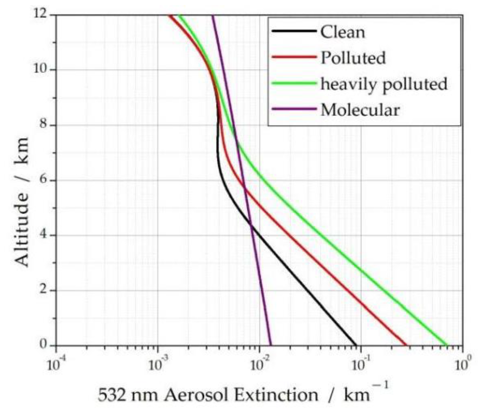
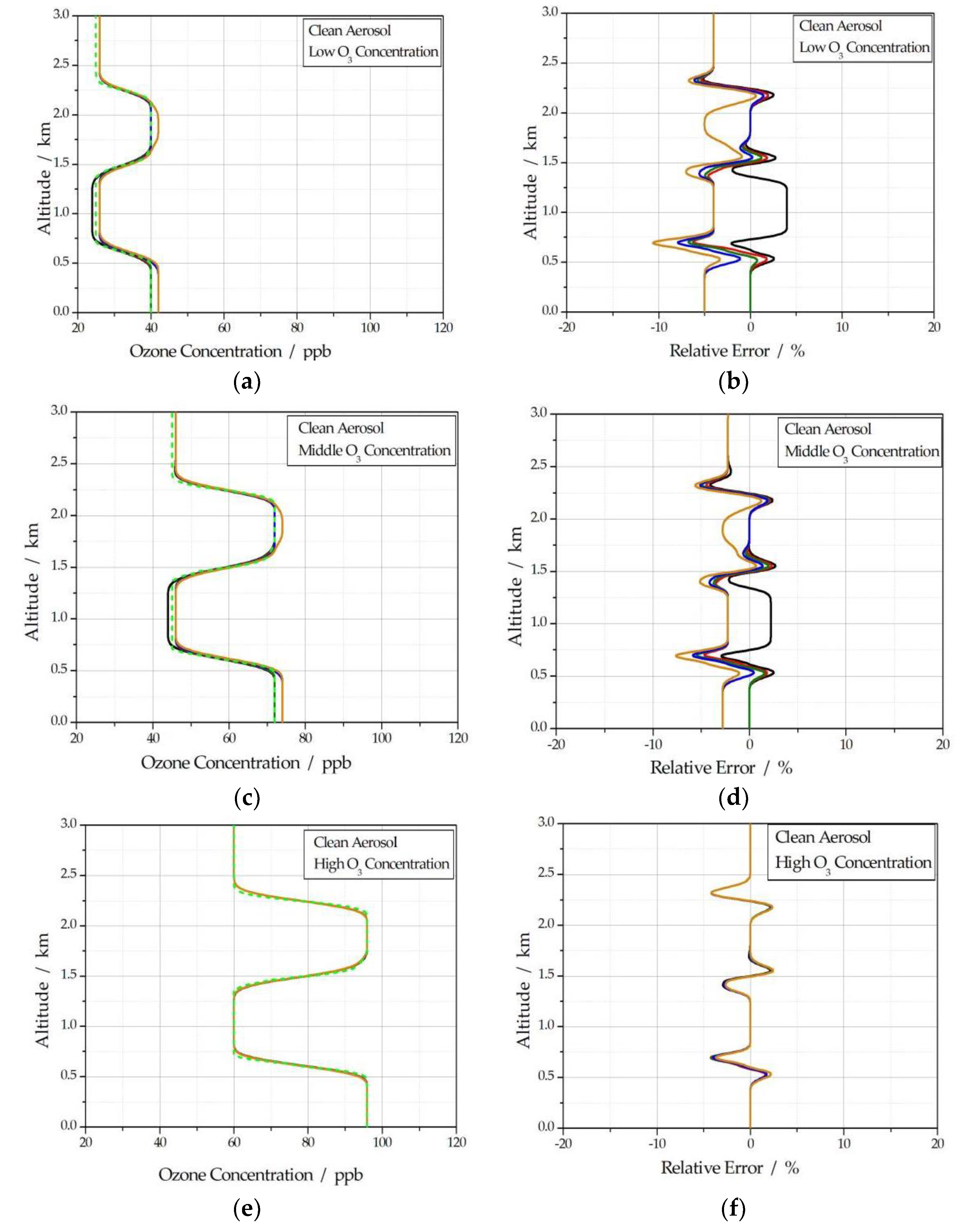
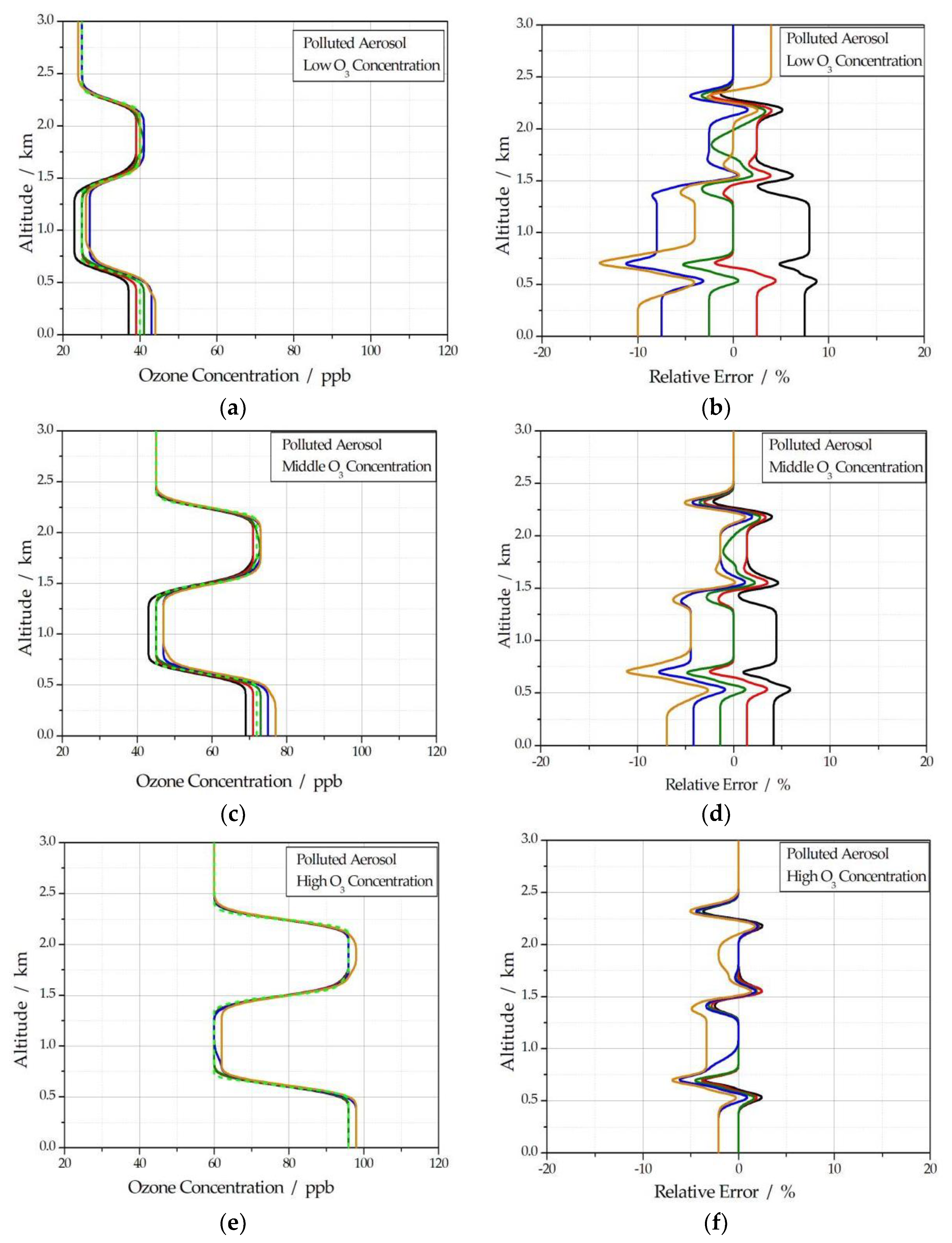
4. Validation and Case
4.1. Validation
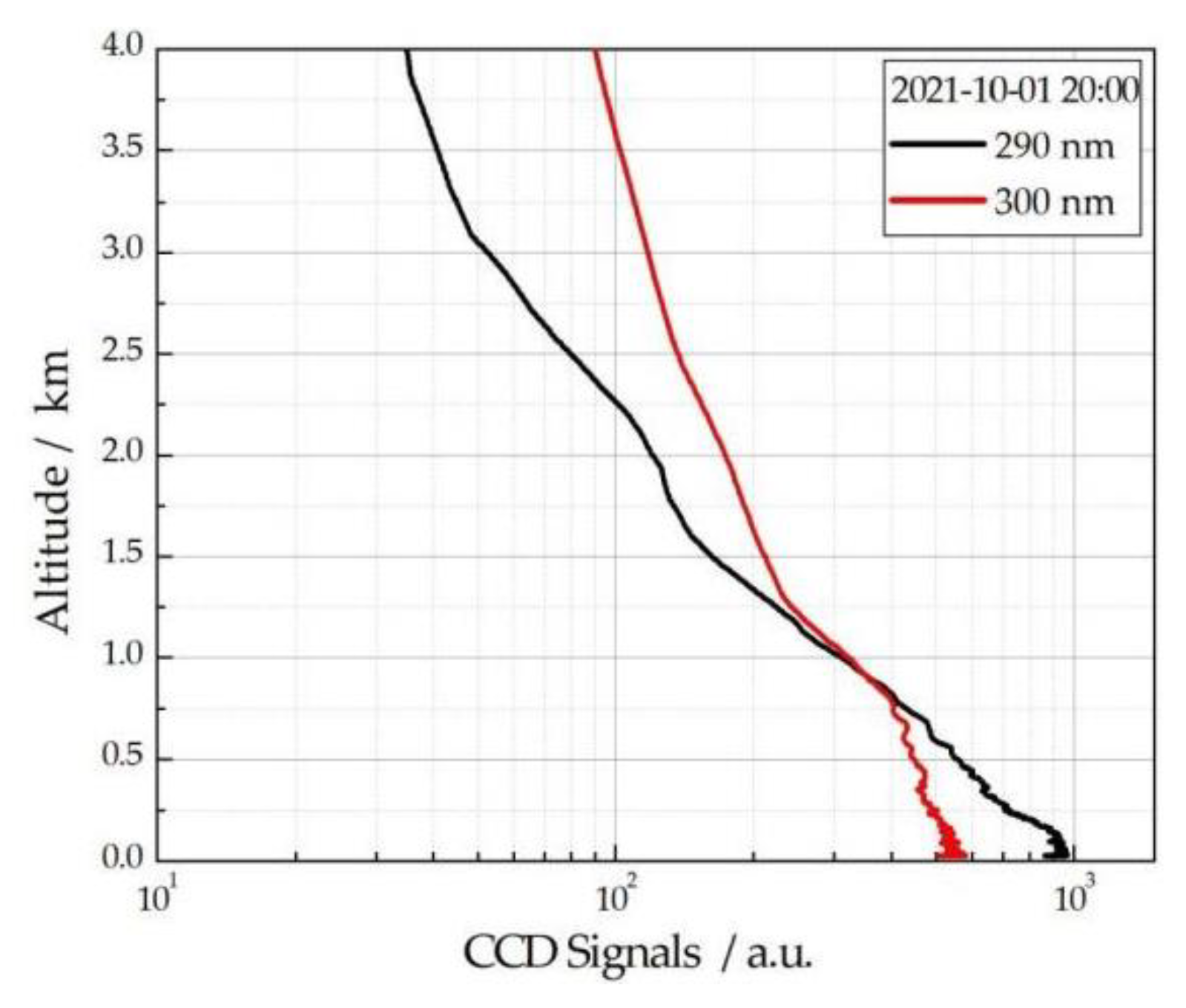
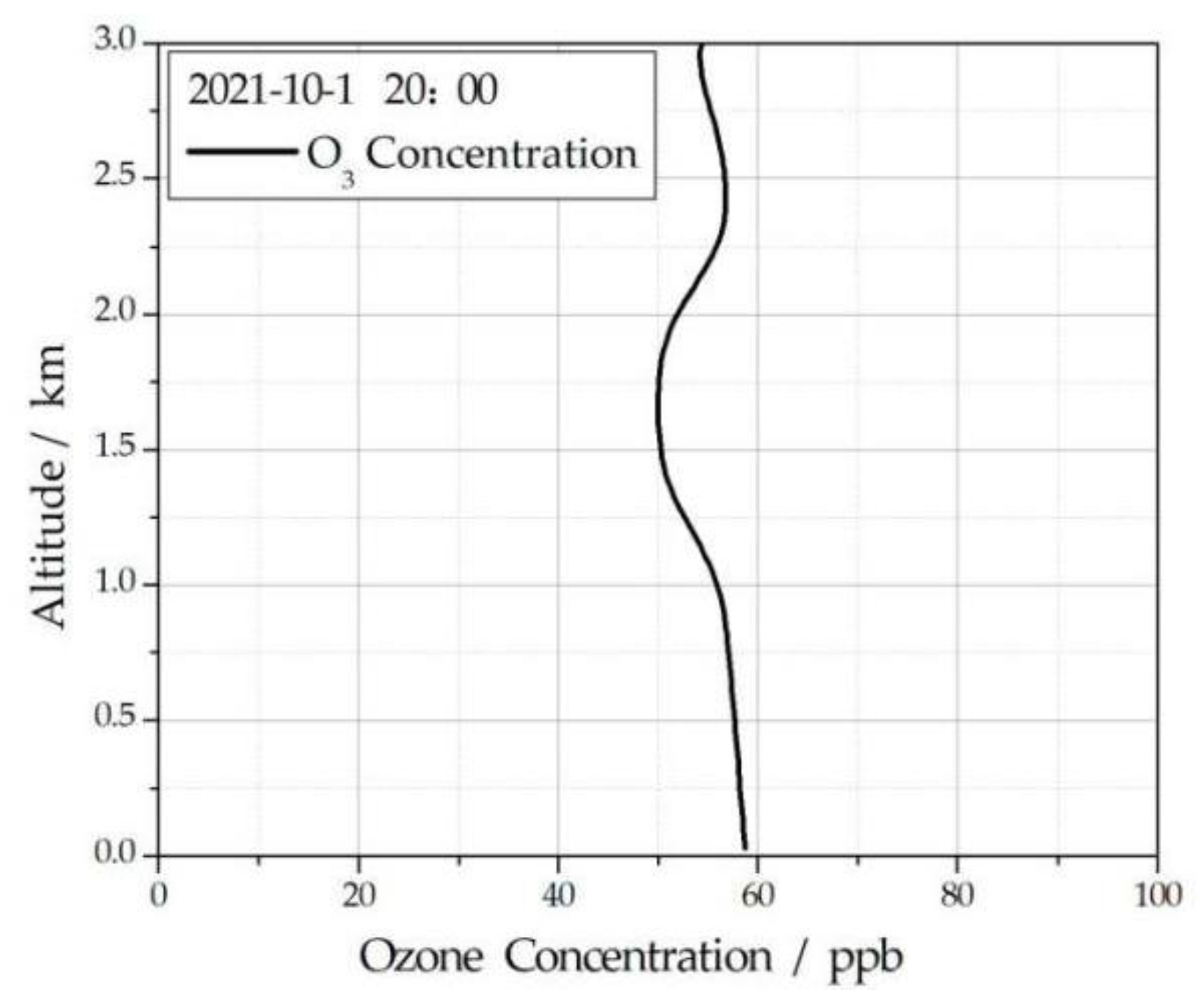
4.2. Case
5. Conclusions
Author Contributions
Funding
Institutional Review Board Statement
Informed Consent Statement
Data Availability Statement
Conflicts of Interest
References
- Li, Z.; Lin, W.; Xu, X. Characteristics of surface ozone at Shangri La region atmospheric background stations. Resour. Environ. Yangtze Basin 2015, 24, 1412–1417. [Google Scholar]
- Wang, G. Atmospheric Ozone Layer and Ozone Hole; Meteorological Press: Beijing, China, 2003; pp. 3–6. [Google Scholar]
- Song, J.; Guan, M.; Chen, L. Analysis on the spatial and temporal distribution of O3 and it’s effect on emergency dispatches in Shijiazhuang, 2013–2015. J. Med. Pest Control 2017, 33, 859–862. [Google Scholar]
- Fleming, Z.L.; Doherty, R.M.; von Schneidemesser, E.; Malley, C.S.; Cooper, O.R.; Pinto, J.P.; Colette, A.; Xu, X.; Simpson, D.; Schultz, M.G.; et al. Tropospheric Ozone Assessment Report: Present-day ozone distribution and trends relevant to human health. Elem. Sci. Anthr. 2018, 6, 12. [Google Scholar] [CrossRef] [Green Version]
- Chen, Q.; Sun, H.; Chen, L. Acute health impacts of ozone exposure on daily mortality in Nanjing. Jiangsu J. Prev. Med. 2017, 28, 366–368. [Google Scholar]
- Liu, D.; Xiao, C. Ozone distribution and effect on respiratory system. Chin. J. Micro Ecol. 2018, 30, 853–857. [Google Scholar]
- Zhu, L.; Liu, M.; Song, J. Spatiotemporal Variations and Influent Factors of Tropospheric Ozone Concentration over China Based on OMI Data. Atmosphere 2022, 13, 253. [Google Scholar] [CrossRef]
- Zhao, Z.; Zhou, Z.; Russo, A.; Du, H.; Xiang, J.; Zhang, J.; Zhou, C. Impact of meteorological conditions at multiple scales on ozone concentration in the Yangtze River Delta. Sci. Total Environ. 2021, 791, 148044. [Google Scholar] [CrossRef]
- Deng, L.; Sheng, S. Spatial Patterns in the Extreme Dependence of Ozone Pollution between Cities in China’s BTH Region. Atmosphere 2023, 14, 141. [Google Scholar] [CrossRef]
- Zhang, Q.; Zhang, X. Ozone Spatial-temporal Distribution and Trend over China Since 2013: Insight from Satellite and Surface Observation. Environ. Sci. 2019, 40, 1132–1142. [Google Scholar]
- Meng, X.; Gong, Z.; Zhang, X. Pollution Characteristics of Ozone in China and Key Regions. Environ. Monit. China 2017, 33, 17–25. [Google Scholar]
- Liu, X.; Li, A.; Chen, H.; Sun, J.; Lu, Z. Scale-adaptive three-dimensional imaging using Risley-prism-based coherent lidar. Opt. Lett. 2023, 48, 2587–2590. [Google Scholar] [CrossRef]
- Duma, V.-F.; Dimb, A.-L. Exact Scan Patterns of Rotational Risley Prisms Obtained with a Graphical Method: Multi-Parameter Analysis and Design. Appl. Sci. 2021, 11, 8451. [Google Scholar] [CrossRef]
- Li, A.; Liu, X.; Sun, J.; Lu, Z. Risley-prism-based multi-beam scanning LiDAR for high-resolution three-dimensional imaging. Opt. Lasers Eng. 2022, 150, 106836. [Google Scholar] [CrossRef]
- Li, Q.; Zhang, Y.; Fan, R.; Wang, Y.; Wang, C. MEMS mirror based omnidirectional scanning for lidar optical systems. Opt. Lasers Eng. 2022, 158, 107178. [Google Scholar] [CrossRef]
- Schotland, R.M. Errors in the lidar measurement of atmospheric gases by differential absorption. J. Appl. Meteorol. 1974, 13, 71–77. [Google Scholar]
- McGee, T.J.; Gross, M.R.; Singh, U.N.; Butler, J.J.; Kimvilakani, P.E. Improved stratospheric ozone lidar. Opt. Eng. 1995, 34, 1421–1430. [Google Scholar]
- Kovalev, A.V.; James, L.M. Differential absorption lidar measurement of vertical ozone profile in the troposphere that contains aerosol layer with strong backscattering gradients: A simplified version. Appl. Opt. 1994, 33, 8393–8401. [Google Scholar] [CrossRef] [PubMed]
- Wang, Z.; Nakane, H.; Hu, H.; Zhou, J. Three-wavelength dual differential absorption lidar method for stratospheric ozone measurements in the presence of volcanic aerosols. Appl. Opt. 1997, 36, 1245–1252. [Google Scholar] [CrossRef]
- De Tomasi, F.; Perrone, M.R.; Protopapa, M.L. Monitoring O3 with solar-blind Raman lidar. Appl. Opt. 2001, 40, 1314–1320. [Google Scholar] [CrossRef]
- Barnes, J.E.; Sharma, N.P.; Kaplan, T.B. Atmospheric aerosol profiling with a bistatic imaging lidar system. Appl. Opt. 2007, 46, 2922–2929. [Google Scholar]
- Tao, Z.; Liu, D.; Wang, Z.; Ma, X.; Zhang, Q.; Xie, C.; Bo, G.; Hu, S.; Wang, Y. Measurements of aerosol phase function and vertical backscattering coefficient using a charge-coupled device side-scatter lidar. Opt. Express 2014, 22, 1127–1134. [Google Scholar] [CrossRef] [PubMed] [Green Version]
- Tao, Z.; Liu, D.; Ma, X.; Shi, B.; Shan, H.; Zhao, M.; Xie, C.; Wang, Y. Vertical distribution of near-ground aerosol backscattering coefficient measured by a CCD side-scattering lidar. Appl. Phys. B 2015, 120, 631–635. [Google Scholar] [CrossRef]
- Mei, L.; Brydegaard, M. Continuous-wave differential absorption lidar. Laser Photonics Rev. 2015, 9, 2014000419. [Google Scholar] [CrossRef]
- Fan, G.-Q.; Liu, J.; Liu, W.-Q.; Lu, Y.-H.; Zhang, T.-S.; Dong, Y.-S.; Zhao, X.-S. A new retrieval method for Ozone concentration at the troposphere based on differential absorption lidar. Spectrosc. Spectr. Anal. 2012, 32, 3304–3308. [Google Scholar]
- Liang, S. Design and Test of CCD Imaging System for Hyperspectral Total Ozone Unit. Ph.D. Thesis, University of Chinese Academy of Sciences, Beijing, China, June 2019. [Google Scholar]
- Tao, Z.; Liu, D. Design and simulation of CCD laser beam imaging technique in detecting ozone concentration profile. Infrared Laser Eng. 2021, 49, 20200383. [Google Scholar]
- Tao, Z.; Liu, D. A numerical inversion method for CCD side-scatter lidar, in Proceedings of International Conference on Remote Sensing. Environ. Transp. Eng. 2013, 31, 350–352. [Google Scholar] [CrossRef] [Green Version]
- Shao, J.; Hua, D. Development of ultraviolet dual-wavelength lidar and analysis of its signal-to-noise ratio. Acta Opt. Sin. 2020, 40, 1201004. [Google Scholar] [CrossRef]


Disclaimer/Publisher’s Note: The statements, opinions and data contained in all publications are solely those of the individual author(s) and contributor(s) and not of MDPI and/or the editor(s). MDPI and/or the editor(s) disclaim responsibility for any injury to people or property resulting from any ideas, methods, instructions or products referred to in the content. |
© 2023 by the authors. Licensee MDPI, Basel, Switzerland. This article is an open access article distributed under the terms and conditions of the Creative Commons Attribution (CC BY) license (https://creativecommons.org/licenses/by/4.0/).
Share and Cite
Shan, H.; Zhang, H.; Ma, X.; Cao, K.; Ji, C.; Tao, Z.; Han, J.; Wang, S.; Zhao, S.; Qi, J.; et al. A Fitting Method of Inverting Ozone Concentration Profile Using Ultraviolet Differential Charge-Coupled Device Imaging Lidar. Photonics 2023, 10, 808. https://doi.org/10.3390/photonics10070808
Shan H, Zhang H, Ma X, Cao K, Ji C, Tao Z, Han J, Wang S, Zhao S, Qi J, et al. A Fitting Method of Inverting Ozone Concentration Profile Using Ultraviolet Differential Charge-Coupled Device Imaging Lidar. Photonics. 2023; 10(7):808. https://doi.org/10.3390/photonics10070808
Chicago/Turabian StyleShan, Huihui, Hui Zhang, Xiaomin Ma, Kaifa Cao, Chengli Ji, Zongming Tao, Jiajia Han, Shenhao Wang, Shaoqing Zhao, Junli Qi, and et al. 2023. "A Fitting Method of Inverting Ozone Concentration Profile Using Ultraviolet Differential Charge-Coupled Device Imaging Lidar" Photonics 10, no. 7: 808. https://doi.org/10.3390/photonics10070808