1. Introduction
The global urgency of groundwater resource management is increasing due to rising exploitation that causes declining levels in aquifers [
1,
2,
3,
4,
5,
6]. Another adverse trend is evident in regional waterlogging and flooding of cultivated fields, infrastructure, and transportation systems [
7,
8,
9,
10]. These problems have multiple causes, including lack of effective regulation, extreme weather events, inadequate drainage, and poor management of irrigation water.
Solutions to many of these problems require analysis of how groundwater and surface water are intrinsically linked and should be treated as a single resource. The solutions will require an assessment of the situations where groundwater management is a critical issue, such as in declining levels in alluvial and confined aquifers, depletion of surface water caused by well pumping, and, in some cases, exploitation of fossil water, subsidence [
11,
12], and degradation of water quality [
13].
Regardless of the situation, integrated approaches to management are required to manage hydraulic connections in the stream-aquifer systems that can lead to significant water exchanges in influent or effluent streams [
14,
15,
16]. The problem is especially important in irrigated semi-arid regions where river diversions and groundwater pumping create interdependencies involving groundwater return flows and streamflow depletion [
17,
18,
19,
20,
21].
Such irrigated semi-arid regions occur throughout the world where crop yields increase with applied irrigation water, such as in parts of Iran, Central Asia, China, Africa, Australia, and western North America [
22]. Depending on its level of development, governance, legal structure, and culture, each region has a unique approach to water rights administration. In some cases, little administration occurs, and water users must work out their problems locally, whereas in others, large-scale effects of groundwater pumping require more formal approaches. Compared to surface water laws, the status of groundwater law and administration of pumping rights is in a relative state of infancy because of the complexity of hydrogeology and the greater difficulty in measuring the short- and long-term effects of pumping. This gap occurs because, while to scientists and engineers, the relationship of groundwater to surface waters is known, to lawyers and courts it is not [
23].
Irrigated regions must work out their unique issues according to physical laws and the needs of their water users. Most reports of experiences are research-based and reflect the perspectives of the analysts. For example, Foglia et al. [
24] reported a modeling project in California that supported the sustainability of environmental goals in a basin. Other researchers propose methods of investigation of aquifer pumping effects on streams [
25,
26].
Based on the complexity of the issue and the status of the knowledge base, it is apparent that the problem of stream-aquifer water rights administration represents a new frontier for research in the combined arenas of hydrology and water resources management. This paper presents a review of the technical, legal, and management issues involved in the administration of stream-aquifer systems, and provides an example of how governance authorities have approached the issues in a semi-arid irrigated region in the United States, the State of Colorado, which now has more than 50 years of experience with integrated management of surface and groundwater. Success in this management approach is essential in the state’s alluvial valleys where most of the population lives, as well as in important agricultural areas where the state must meet interstate compact requirements. The experiences gained in 50 years of management have included engineering, legal, and social adjustments, and regulatory and management approaches have relied heavily on hydrologic and engineering advances, with emphasis on data and modeling. They provide perspectives that may aid water managers and regulators in other regions to compare and adapt their approaches. The experiences are explained to include the setting and explanations of how the stream-aquifer issues emerged, the challenges they created, the impacts, the institutional and hydrologic responses, and the lessons learned.
2. Technical, Legal, and Management Issues of Stream-Aquifer Systems
The technical issues of stream-aquifer systems were explained in an extensive report by the United States Geological Survey, which traced the beginning of the systematic study to 1940 and the work by Theis, who investigated the problem of well-pumping [
17]. After an extensive review of the studies of stream-aquifer analysis, the authors concluded that the major issues were identifying sources of water to a well, depletion of streamflow and its time response, effects of confining layers on streamflow depletion, and the distribution of streamflow depletion along stream reaches. Management-related issues stemming from these problems include analysis of the time rates of pumping and well shutdown and the difficult problem of basin-wide analysis, where hundreds, or even thousands, of wells may draw water from hydrologic systems.
The use of models to simulate pumping effects has focused on simplified analytical modeling methods, which cannot represent aquifer heterogeneity or complex stream and aquifer geometries. Numerical methods are better for handling the complexities of groundwater systems and accounting for the effects of pumping histories from large numbers of wells. Their disadvantages are, of course, based on their complexities, cost, and need for accurate data which may not always be available.
The legal complexities of stream-aquifer interconnections are embedded in the hydrogeology, the uncertain flows of groundwater, the difficulty of determining how pumping impacts streams, and other technical questions outlined above. As Dellapenna [
23] explained, these legal issues are aligned with questions such as how to limit use to ensure sustainability and how much of the pumped water eventually will find its way back to an aquifer, even if not the aquifer of origin. The legal management issues are to regulate pumping to maintain water tables and return or substitute at least some of the extracted water. The author thought that regulations, while intended to sustain scarce and ambulatory resources, have not been entirely successful. He also observed that slow-developing public awareness about groundwater leads to little thought given to resource management and toward a “tragedy of the commons”, where collective action fails to sustain a shared resource. The public awareness problem also saps trust in management institutions, as in a cited case involving local groundwater districts in eastern Colorado and Kansas where some 40% of irrigators doubted whether districts served their interests.
Management issues of stream-aquifer systems are derived from the technical and legal challenges involved, primarily that computation of the exact impacts of pumping on streams is inherently complex and that the legal system, together with its public opinion branch, does not trust experts or the regulatory system to protect their interests. This means that management institutions, such as groundwater districts or river basin organizations, face uphill battles to develop effective approaches and, even then, they must negotiate with the regulatory system, including the justice system, to gain approval for their methods.
3. Stream-Aquifer Regulation within the Water Rights System of Colorado
Colorado is a mid-continent state with an area of 104,094 square miles (269,603 square km) and a population of almost six million [
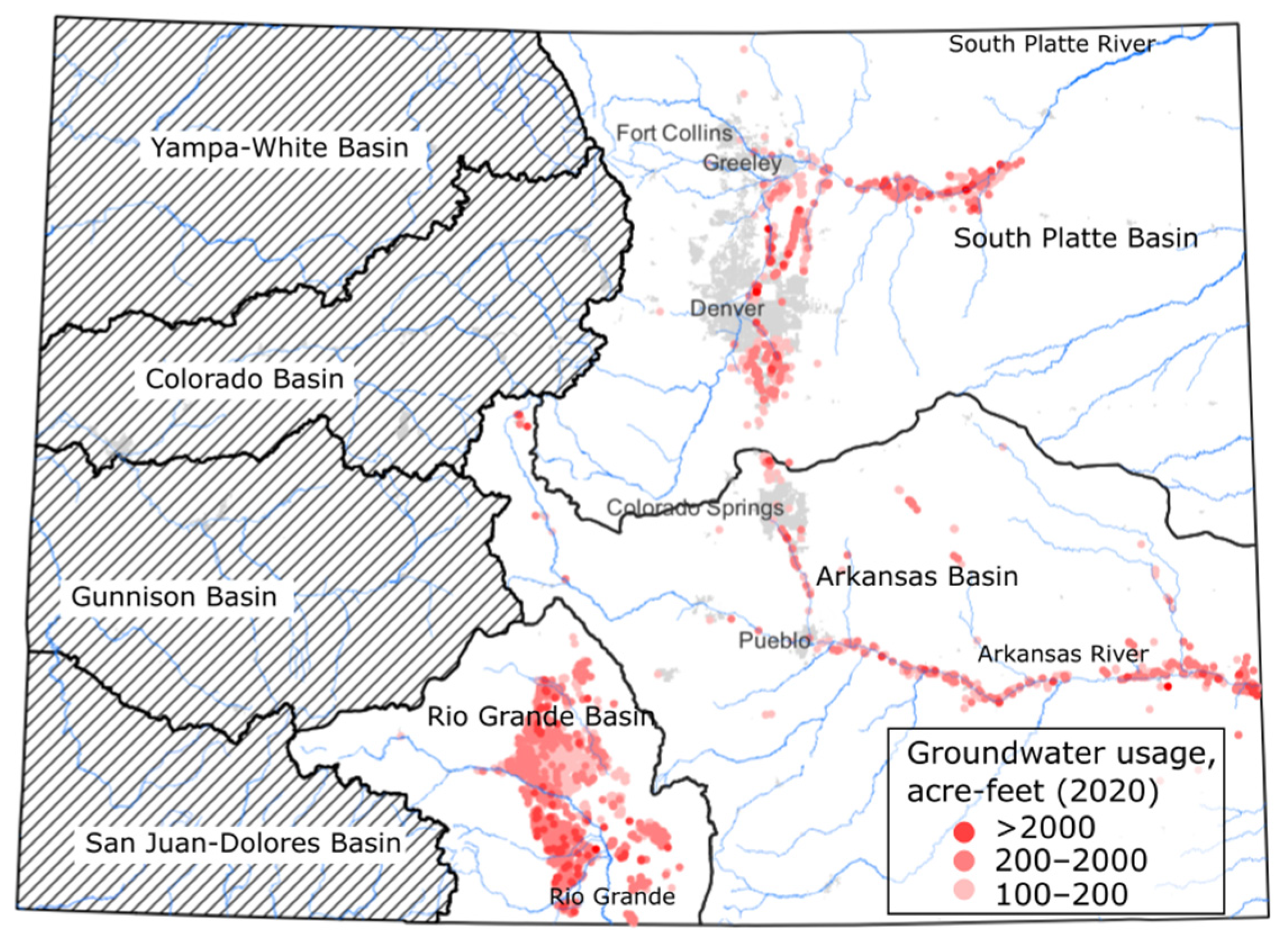
27]. Based on the frequency of reports and coverage by the scientific research base, Colorado’s experience with stream-aquifer management is more developed than in other western states. A national map of the United States would show the state just west of the center of the nation. Colorado has several distinct regions comprising the eastern plains, the Front Range, the mountains, and the western plateau (
Figure 1). The general north-to-south line of the Continental Divide divides the state generally into east and west slopes. The average annual precipitation is 17 inches (432 mm), which varies markedly between the plains and mountain parts of the state [
28]. Runoff from mountain snowpack provides much of the streamflow leaving the state on both sides of the Continental Divide.
Colorado has complex geologic structures, and the focus here is on the alluvial valleys of two major eastern slope rivers, the South Platte and the Arkansas, and a distinct region in the headwaters of the Rio Grande River. The basins of the South Platte and Arkansas rivers contain most of the state’s population, mainly in the Front Range cities shown in
Figure 1. These two basins also contain most of the state’s irrigated land and each river has an interstate water compact with neighboring states [
29]. In addition to managing water quantities in the rivers, both have water quality issues. The Rio Grande basin is in the San Luis Valley, which is only sparsely populated but has extensive agriculture and water uses with regulatory controls to respond to interstate issues.
Figure 1 illustrates the basins west of the Continental Divide as hatched areas and illustrates areas of heavy groundwater pumping in the South Platte, Arkansas, and Rio Grande basins.
The functions of water rights administration in Colorado are explained by authors such as Stenzel and Cech [
30], who described the regulatory perspective. In the US, water rights are based primarily on state laws and Colorado follows the appropriation doctrine, sometimes called the “priority doctrine” with “first in time, first in right” governing entitlement to water. The doctrine is embodied in Article XVI of the Colorado Constitution, which was developed at the time of statehood in 1876. Variations of the doctrine are used throughout the drier parts of the western United States. Some states, such as California, use mixed water law systems because they have both arid and humid parts. Colorado’s system is sometimes referred to as a pure appropriation doctrine because it applies the same across the state and is based on strict priorities. In 1879, the Colorado Legislature assigned adjudication of water rights to the state courts and created the first water districts and offices of water commissioners to oversee diversions. Soon thereafter, the Legislature created Division Engineers for each river basin and a State Engineer’s Office to oversee the statewide system.
The legislation requiring analysis of stream-aquifer connections stems back to the first well developed in the South Platte basin in 1886 using a centrifugal pump driven by a steam engine. This led to the first lawsuit between ground and surface water users, with the court finding the well in violation of the doctrine of prior appropriation. Pumps installed during the period of rural electrification in the 1930s led to much more groundwater pumping. Prior to 1957, no permit was required for a well and there were few court decisions because hydraulic connections were not well understood. This began to change, and the Groundwater Management Act of 1965 affirmed that groundwater users must comply with the appropriation doctrine and required that the State Engineer’s office could only permit a well if it would not injure senior rights. The Act also confronted the State Engineer with the difficult task of shutting off wells, although regulation was relatively flexible, at least initially.
The Colorado Legislature passed the more comprehensive Water Rights Determination and Administration Act in 1969 to clarify procedures and provide for improved water administration. This Act organized the seventy water districts and seven water divisions into the present system with a water court and division engineer in each river basin [
31]. It defined the roles of water divisions, division engineers, water judges, referees, and water clerks and it set the intent to “integrate the appropriation, use, and administration of underground water tributary to a stream with the use of surface water, in such a way as to maximize the beneficial use of all of the waters of this state”.
The 1969 Act provided a more serious approach to integrating wells with the surface water system than had existed before. Specifically, it required the user of tributary groundwater to provide replacement water at times when a water rights call is on the river. The complex system of aquifers requires different approaches to management. Tributary aquifers are considered hydrologically connected such that they influence streamflow directly. For non-tributary aquifers outside of designated basins, the requirement is that pumping will not within 100 years deplete streamflow at a rate greater than 0.1% of the annual rate of withdrawal.
There are eight designated basins with non-tributary aquifers in the eastern plains, which have little surface water. These are managed by 13 Ground Water Management Districts. Another category comprises the not non-tributary aquifers located in the Denver Basin, which is generally under the metropolitan area of the city. These do not influence streamflow as directly as tributary aquifers significantly, and they are regulated differently because of their importance to the economy. Regulation of the Denver Basin requires that at least 4% of pumped water be returned to surface streams. The State Engineer administers non-tributary and Denver Basin groundwater, and the Colorado Groundwater Commission and local groundwater management districts administer the Designated Basins [
32].
The South Platte Basin was the first in the state to undergo intensive water development for farming, cities, and industry, and its population growth has been much greater than other basins in the state. The development of groundwater sources has been essential to supplement over-appropriated sources of surface water. In the basin, water is cycled from the river to the fields, to the aquifer, to the river, and then back again repeatedly from Denver to the Nebraska state line. Return flows are determined by farming practices, with high returns from flood irrigation and lower returns from the use of sprinklers. Groundwater pumping from the alluvial aquifer leads to the depletion of river water [
17,
21], and wells are either shut off or managed through augmentation plans, where recharge ponds mimic return flows to the river that would occur without well pumping. In some cases, canal seepage to the aquifer is used for augmentation credit [
33], to allow pumping in subsequent years.
After the first well in the basin in 1886, a lawsuit was filed between ground and surface water users, and the court found that the well was in violation of the doctrine of prior appropriation. Despite this finding, prior to 1957 no permit was required for a well and there were few court decisions because hydraulic connections were not well understood. During the early and mid-20th Century, well development and availability of electric power in rural areas tapped more groundwater, and there was a total of 3200 wells pumping at least 100 GPM (379 L/min) by 1972. Only a fraction of the farms involved reported leasing surface water to compensate, and water right owners began to argue about depletions.
The Groundwater Management Act of 1965, which affirmed that tributary well users must comply with the appropriation doctrine, gave the State Engineer the difficult task of shutting off wells permanently, although initial regulation was flexible. In the 1967 Fellhauer case, the court ruled that the State Engineer had not developed rules and regulations to administer wells with the priority system, and a 1968 Engineering report found that wells were reducing stream flows.
These developments set the stage for the 1969 Act and signaled the beginning of the end of unrestricted groundwater pumping. In this period, the new rules were challenged, and various agreements were made. The legislature gave well owners the right to organize and up to three years to file a plan of augmentation. The State Engineer could continue using substitute water supply plans. Well owners were encouraged to form associations or conservancy districts to comply. In the 1970s two well augmentation groups were created to operate under the substitute water supply plan rule.
The period from 1980 to 2000 was wet, but a severe drought struck in 2000 and the State Engineer began to require replacement of out-of-priority depletions with augmentation plans as calculated by a stream depletion factor method. The record drought and a related lawsuit about augmentation plans led to a greater focus on stream-aquifer interactions and well shutdowns in the basin. As the drought worsened, river calls were earlier and lasted longer than in the past. Agreements were dismantled and some farmers with both wells and surface rights stopped using groundwater to reduce the amount of water they would need for augmentation plans. This resulted in irrigation ditches placing river calls even earlier and caused older patterns of river calls to move earlier in the season, which impacted recharge operations during dry periods [
30].
The seeds were planted for discord as increased use of center pivot systems, improved irrigation efficiencies, and greater recapture of imported water began to reduce return flows to the river. The associations that had formed for augmentation started coming apart and some well owners filed individual plans of augmentation and withdrew from the common pool. The associations did not have enough substitute water supplies and had to cease operations.
The lawsuit filed in 2000 to address a situation in the Arkansas Basin affected water management in the South Platte in a major way. Litigation was between the Empire Lodge Homeowners Association and the Moyers family, and it addressed the State Engineer’s authority to approve substitute water supply plans. The outcome, together with the drought led to the shutdown of about 2000 tributary groundwater irrigation wells. This had severe social and economic impacts as tens of thousands of acres (hectares) of productive agricultural lands reverted to dryland crops or weeds [
34,
35].
As evident in the South Platte Basin, the parallel evolution of water demands, drought, water rights regulation, and modeling technologies illustrates a hydro-legal approach to confronting stream-aquifer interactions. This approach is illustrated vividly in a major ruling by the US Supreme Court (SCOTUS) about water management in the Arkansas River Basin.
In the Arkansas River Basin, stream-aquifer interconnections are like those in the South Platte, but all water is managed under an interstate compact with Kansas. The basin has areas of high groundwater levels caused by inadequate drainage [
36], but any change in irrigation practices from flood to sprinkler systems cannot modify the amount of river water delivered to Kansas.
The Arkansas River Compact between Colorado and Kansas signed in 1949 led to controversies over stream-aquifer modeling [
37]. A long period of disputes began in 1902 with Kansas’ complaints that Colorado was using excessive amounts of water. The SCOTUS ruled that no decision could be made without further evidence. Subsequently, the states tried different legal maneuvers and the lack of definite outcomes and high costs of litigation led to the 1949 Compact. In 1985, Kansas filed a complaint that Colorado had overused their compact share of water because groundwater pumps installed after 1949 and a Winter Water Storage Program had depleted river flows. In 1995 a special master ruled that groundwater pumping violated the compact, and the SCOTUS accepted his verdict. Colorado has assessed damages for the excess water use.
In subsequent rulings, the court decided in 2009 that a Hydrologic-Institutional Model (H-I Model) was required to determine depletions and accretions to flow into Kansas caused by groundwater pumping and replacement. The model simulates the hydrologic and institutional systems that influence flow from Pueblo, Colorado to the state line and estimates the flow of the Arkansas River that would have occurred in the absence of post-compact well pumping [
38]. The surface water simulation includes native streamflow, transmountain deliveries, tributary inflows, reservoir operations, and irrigation diversions, while the groundwater component includes the effects of well pumping and recharge. The institutional system modeled includes rules for the diversion of surface water, operation of John Martin Reservoir, resolutions of the Arkansas River Compact Administration, operation of other off-channel reservoirs, and replacement operations.
There was considerable discussion of the model in the case. The Special Master explained that modeling the Arkansas River Basin is extraordinarily complex. Despite continuing refinements, the Special Master held that the model is not accurate on an annual basis and adopted a proposal from Colorado that results be applied over a ten-year period to average out errors. Also, he advised that continuing needs to update the model would be required, although the states might disagree on changes to be made. There was discussion of whether a River Master should be appointed to resolve modeling issues and make other decisions, but this did not occur. Water management and modeling decisions were left to the Arkansas River Compact Administration, although this was not considered an ideal solution due to the possibility of future disputes [
37].
Water management in the Upper Rio Grande Basin in Colorado’s San Luis Valley has focused on meeting agricultural needs and compliance with two interstate compacts. Compared to the South Platte and Arkansas basins, it has much less urban and industrial demands [
39]. The Valley is a major potato-producing region, and water use has been ruled unsustainable. The Valley only receives 7 to 10 inches (178 to 254 mm) of precipitation per year, so surface runoff lacks an abundant supply, but a vast aquifer system is linked to the river. As well pumping increased, aquifer levels and river flows declined to the point that Colorado’s ability to deliver compact water to New Mexico and Texas was threatened [
40].
The Rio Grande Basin in the Valley has several productive alluvial aquifers with saturated thicknesses of several kilometers [
41]. The confining units are as shallow as 20 m in some parts of the Valley. This shallow confined aquifer spurred the development of early artesian wells in the late 1800s for irrigation, and with electric power, many more were drilled later. The interstate issues of the basin date back to the Rio Grande Compact of 1939, which set required flows from Colorado to New Mexico and then to Texas. By 1965, Colorado had accumulated a water debt of roughly one million acre-feet of water, resulting in severe curtailment of water use in the valley. In response, the State Engineer placed moratoriums on new wells in the confined aquifer in 1972 and on those in the primary unconfined aquifer in 1981 [
42]. In the 1990s, speculative proposals to pump water out of the valley to the front range began. The first proposal was denied in court because groundwater was considered tributary to natural streams. Later proposals have also failed, but water speculation efforts continue. The 2002 drought prompted further legislation to avoid depletion in the valley. Subdistricts were formed to remedy injurious groundwater depletions and replenish surface water to fulfill Colorado’s compact obligation. Farmers have worked voluntarily since then to reduce groundwater use and restore Rio Grande surface flows by establishing fees with revenues used to retire farmland.
A groundwater model to quantify the impact of withdrawals on streamflow depletion was initiated during the 1990s [
43]. New rules in 2004 led to the Rio Grande Decision Support System (RGDSS) study to model impacts on its artesian pressures. To support the RGDSS, the State Engineer released a Groundwater Measurement Rule in 2005 to require wells in Water Division 3 to meter water and report annual water pumped from large wells. In some parts of the Valley, the hydrogeology is not understood well enough to model accurately with the RGDSS [
40,
42].
4. Modeling Issues in Support of Water Rights Administration
While the State Engineer’s office was required to administer interconnected stream-aquifer systems of water rights by the 1969 Act, it lacked hydrologic models and the databases were inadequate. The quantitative method used at the time was the analytical Glover-Balmer model [
44], which estimates the time-dependent flow rate and volume of stream water that enters the aquifer due to pumping from a full-penetrating groundwater well. The model has been popular since its inception [
45] due to its ease of use, as calculations can be implemented in spreadsheets or even by hand. The Glover-Balmer model has many simplifying assumptions, such as a straight-line river, homogeneous aquifer, fully penetrating well, fully penetrating river, and the same hydraulic conductivity for the aquifer and streambed. Later models were published to relax some of the assumptions with modifications [
46,
47]. These models can be used in spatial and temporal superposition to estimate streamflow depletion from multiple pumping wells and from a time series of pumping rates, including the amount of streamflow depletion that occurs after the pump has been shut off.
Due to inherent assumptions in their derivation, these analytical models are too simplistic for most situations, especially when pumping wells are more than a few kilometers from streams [
48]. However, because of their ease of use, such as implementation in spreadsheet format for water managers to use, they have been accepted as “correct” models in water rights cases and augmentation plans. A typical application would be to use the analytical model in a spreadsheet to estimate the volume of streamflow depletion through time and then model where recharge ponds should be located to mimic return flows that would occur without pumping.
Researchers continued to develop new groundwater models based on solutions of partial differential equations using finite difference and finite element methods. A promising effort over a 15-year period in the 1970s and 1980s developed the Stream-Aquifer Model for Management by Simulation (Samson Model) [
49] for the South Platte Basin. By the 1990s, modeling had advanced to become effective as a tool for management decisions. This was the beginning of the development of Decision Support Systems by the Colorado State Government for each river basin.
Numerical models such as MODFLOW and HydroGeoSphere are time-consuming to create, but they are more realistic for the simulation of physical processes than analytical models [
9,
33]. They have been applied in the South Platte Basin for research and via the SPDSS, as well as in the Arkansas River Basin [
36] to investigate the impacts of management strategies on groundwater levels and return flows, and to quantify the impact of future climate change [
50]. These physically based spatially distributed models can be used effectively to investigate groundwater-surface water interactions and management. However, defending complex numerical models in water courts can be a daunting task and, due to decades of use and acceptance, analytical models continue to be used for water rights cases and streamflow depletion calculations. In some venues, the prospect of developing numerical models is daunting due to their costs, and another challenge is to apply them to complex hydrogeological situations. This appears to be another situation where technology outpaces implementation, and gaps will probably widen when artificial intelligence and data-driven models are available.
The early stages of model development were limited by a lack of data, particularly groundwater withdrawals. Data to validate models and prepare augmentation plans were scarce and not well organized. Colorado State University digitized water rights records from the State Engineers Office, and this effort led eventually to the state’s current HydroBase database [
51]. Lawsuits prompted by a drought of 2002 led to mandatory metering of all non-exempt wells in the South Platte, Arkansas, and Rio Grande Basins, and resulted in high-quality groundwater data.
Data issues for testing of models involve groundwater levels, streamflow, and depletion volumes. Surface water data are from US Geological Survey (USGS) gages. Groundwater data include wells belonging to the USGS wells and Colorado Division of Water Resources wells. While these are increasing in number, more are always needed. Groundwater withdrawal data come via metering of use, which was limited until 2005–2010 when lawsuits from the 2002 drought led to their requirement.
Due to the limited data, consumptive use models were used to include the location of irrigated fields and crop water demand [
52]. Stream depletion from these is difficult to estimate because the magnitude of pumped water is small compared to streamflow. A study of a short stretch of the South Platte River showed that, although depletion from high-capacity pumping wells occurs, the volumes can only be quantified confidently at lower river flows of the same order of magnitude as the pumping rates [
53]. For larger rivers with high flows, the volume of pumping-induced streamflow depletion is hard to measure with field instruments.
5. Discussion, Conclusions, and Future Directions
Water interactions in stream-aquifer systems pose significant challenges in semi-arid areas like Colorado, and their complexities will become evident in many other places as groundwater management challenges are exacerbated by problems due to over-pumping and climate change. Confronting these challenges successfully will require effective management and regulatory systems that use advanced tools and valid data to inform decisions by managers and governance authorities.
The review of Colorado’s experiences demonstrates how models and data management can be improved, but many obstacles remain in place. It shows how continued work is required to address the complexities of local and regional hydrogeology and institutional systems that are adapting to the challenges of water management. Issues to confront include adequate groundwater data, effective modeling strategies, organizational arrangements to facilitate collective action, building water management capacity, and legal challenges.
In Colorado, groundwater data are improving, but the complex hydrogeology and diverse types of aquifers continue to present formidable challenges. Data mandated in court settlements is especially useful when it is tested in adversarial legal proceedings, but research-based data can also be quite useful, especially when published in peer-reviewed venues. Compiling these data in ways to support management and regulatory systems presents organizational and financial challenges stemming from unclear responsibilities, fragmentation, and the cost of data management systems.
Stream-aquifer models keep improving and evolving decision support systems provide visual displays and tools to enable stakeholders to examine management scenarios. However, data uncertainties and the hidden nature of model coding create doubt in the minds of referees and judges and can explain why, in Colorado, the courts have not accepted advanced numerical models and continue to rely on older analytical models that are simpler but not able to simulate complex systems well.
Management districts, such as those organized in the San Luis Valley, provide a means to use common pool resource principles to manage water resources. In such local districts, the introduction of innovative tools such as aquifer-storage-recovery systems or management of well-pumping to stabilize stream flows may help. While this approach may work in relatively small areas, it faces challenges when stream-aquifer interactions extend over large distances in priority-based water right systems. The use of larger-scale models and coordinated management and regulatory approaches will be needed.
Colorado’s experience with a court-based regulatory system connects water administrators in partnership with the legal system. Once a management plan is approved through the courts, the State Engineer’s Office has a set of rules to follow and the complexity to administer water is reduced, but the approval process and the possibility of later legal challenges pose challenges to the reliability and trust in the regulatory system.
In Colorado, the historical legal controls on water management were established coincidentally with the appropriation doctrine of water rights. Subsequently, generations of water lawyers have become familiar with hydrology and water management strategies and engineers, modelers, and regulators have learned a great deal about water laws. The solution of the problems that block the acceptance of advanced model strategies will depend on continued joint work between the technical and legal communities. To support this work, researchers can demonstrate the superiority of newer models over older ones by using court case outcomes to demonstrate the impacts of errors in using outdated methods.
Looking to the future, water managers and their hydrologic support staff will face the technical, legal, and management quandaries outlined in the paper. Hydrogeologic diversity, lack of data, and modeling complexities and expenses will inhibit the application of the most advanced technologies to regulatory and management control schemes. The slow evolution of legal approaches to confront technical and environmental problems will mean that water managers cannot expect solutions from the justice system, and they must continue to innovate with new approaches without assurance of acceptance of their methods. Meanwhile, the older analytical approaches will not go away and may provide useful constructs to explain to the public about their choices and the limits of the regulatory system. Rapidly advancing data sources based on remote sensing, along with data methods based on machine learning and artificial intelligence may supplant some of the numerical models of today. As water becomes scarcer and our shared dependence on it intensifies, the methods and issues outlined in the paper will come increasingly into focus in the water management community.


