Article

The Effect of Horizontal Specific Temperature on the Flow Systems of the Transdanubian Mountains (Hungary)

1
Department of Geography, Savaria University Centre, Eötvös Lóránd University, 9700 Szombathely, Hungary
2
Department of Mathematics, Savaria University Centre, Eötvös Lóránd University, 9700 Szombathely, Hungary
*
Author to whom correspondence should be addressed.
Hydrology 2023, 10(7), 145; https://doi.org/10.3390/hydrology10070145
Submission received: 26 May 2023 / Revised: 16 June 2023 / Accepted: 30 June 2023 / Published: 7 July 2023
(This article belongs to the Special Issue Hydro-Geology of Karst Areas)

Abstract

:
This study interprets the development of various flow types of the Transdanubian Mountains. For this, pressure was calculated at different depths and along some profiles the horizontal, specific temperature was calculated based on geoisotherms. This is the value of temperature distribution calculated to a given place. It has been established that upwellings develop at sites where the value of horizontal specific temperature is more than 0.8 °C, and partial upwelling can be detected where this value is between 0.6 °C and 0.8 °C. Outflow from the karst is present where this value is below 0.4 °C. Taking into consideration these values, the water temperature of karst springs and the caves of heat effect, the distribution of various flow types are determined. The flow type is also affected by the fault structure of the basin. In the case of horsts subsided to a great degree, since the sediment is thick above such horsts, the water is not able to flow upwards and towards the mountains because the hydrostatic pressure does not prevail any more. Above horsts subsided to a lower degree, the sediment is thin and thus, the water moving upwards is able to flow through.

1. Introduction

In this study, the regional flows of the Transdanubian Mountains surrounded by basins are studied, since flows of different types occur in the mountains which are relatively at a small distance from each other. However, geoisotherms have relatively uniform development. Thus, the existence of flows of different types is not caused by the geoisotherms of the mountains (since, according to geoisotherms, at the same depth, the temperature is lower than in the environment of the mountains, if the hydrostatic pressure did not have an effect, and a flow in the direction towards the inner side of the mountains would be present). Therefore, it is studied how the lateral change in temperature at the interface of the mountains and the surrounding basin, and how in the area of the latter affects flows between them. Based on geoisotherm maps, the lateral change in temperature in the zone of the interface can significantly differ in various parts of the mountains. With calculations based on geoisotherm data, horizontal temperature changes are given which can be associated with flows of various types.
It is described where the flow of fluid has an upward direction or a direction from the mountains towards the surrounding basin at different values of the horizontal specific temperature.
Hungarian hydrogeological research has shown that the karstwater of the mountains constitutes a uniform system, the flows of which have been detected early [1,2]. This is possible because in the mountains, Triassic dolomite developed in great thickness uniformly which stores karstwater and thus, regional flows may develop in it.
Outflow from the mountains and upwellings at the mountain margins have been distinguished [1,3]. Presently, upwelling occurs at two sites in the mountains, at the Buda Hills and at Hévíz (western part and foreland of the Keszthely Mountains). Pávai and Vajna [4], and Jakucs [5] mainly studied upwelling in the Buda Hills. Later, Kovács and Müller [6], Mádl-Szőnyi and Tóth [7], and Mádl-Szőnyi et al. [8] investigated the upwelling at the margin of the Buda Hills. Upwelling may be recent and paleo [6]. Former upwelling can be detected at the northern margin of the mountains (Gerecse and Pilis Mountains) and in the Balaton Uplands. According to the recent upwelling origin, some researchers think the fluid originates from the meteoric waters of the Buda Hills [9] and thus, the component of basin origin is subordinate. According to other opinions, components of basin origin are significant, which refers to the fact that waters originate from the surrounding basin (Great Hungarian Plain) and the infiltrating water also plays a role in the upwelling [10].
Regarding the regional flows of the Transdanubian Mountains, outflows are more widespread. Approximately, a 25–50 km section of mountain margins has upwellings. Below, the relationship between the distribution of horizontal specific temperature values and the distribution of flow types is described (according to our knowledge, calculations and applications of such values have not been carried out to study flows). To the effect of upwellings, thermal springs and hypogene caves [11] and thermal caves develop at former upwellings.
The flow system of the karst can be local and regional [12,13,14]. Local flows develop on a part of the karst and the ascending branch is absent at them [14]. Local flows are situated above the base level of erosion and they are connected to valleys located above this level [14]. In the Bakony Region mountain part of the studied area, local flows developed at impermeable intercalations [15]. The regional flow systems of karst areas develop in the total expansion of the karst. Hypogene karsts develop at the ascending hypogene branches of regional flows which reach the surface at the interface of the karst and the bordering basin. Hypogene karsts are characterised by caves with features and concretions indicating thermal effect [12,16]. Their rich dissolved material content can be traced back to the mixing corrosion taking place here, to H2S dissolution and CO2 dissolution [12,14,16,17].
However, regional flows do not have a hypogene section everywhere. In this case, the current enters the karstic (or non-karstic) rocks of the bordering basin and then arrives at the non-karstic rocks of the basin.

2. Geological and Hydrological Setting

The Transdanubian Mountains are a range with a NE–SW strike between the Little Hungarian Plain (from the NW) and the Great Hungarian Plain (SE). They are bordered by the River Danube and the volcanic Visegrád Mountains (which although is on the right bank of the Danube, belongs to the North Hungarian Mountains) from the NE, and by the Zala Hills in the SW (Figure 1).
The mountains are part of the Alpaca Macrostructural Unit [18], whose Mesozoic carbonate rocks terminate at the River Rába in the basin floor of the Little Hungarian Plain in the NW [18,19,20] (Figure 2). In the NW–SE direction it is 200 km long, with an expansion of 20–50 km perpendicular to this. Its average altitude is 300–400 m, and only some of its mountains are above an elevation of 700 m. The mountains are of a fault structure and they are built up of horsts of different elevations. They are separated into several parts along faults of a graben structure with a NW–SE direction (Figure 3). These are the Bakony Region (including the Keszthely Mountains, the Balaton Uplands, the Northern Bakony, the Southern Bakony and Bakonyalja), the Vértes Mountains, and the Dunazúg Mountains (involving the Gerecse Mountains, the Pilis Mountains and the Buda Hills).
Figure 2. Large structural units of Transdanubia [19] (modified). Legend: 1. Mesozoic carbonates at the surface, 2. Mesozoic carbonates on the basin floor, 3. quaternary volcanics at the surface, 4. Palaeozoic crystalline floor, 5. crystalline rock at the surface, 6. Paleozoic sediments, 7. Paleozonic plutonites, 8. margin of mountains, and 9. the place of the profile of Figure 4.
Hydrology 10 00145 g002
Figure 3. Parts and flow systems of the Transdanubian Mountains. Legend: 1. places of flow and their classification, 2. Visegrád Mountains, 3. Pilis Mountains, 4. Gerecse Mountains, 5. Buda Hills, 6. Northern Bakony, 7. basins of the Bakony Mountains, 8. Eastern Bakony, 9. Southern Bakony, 10. Pápai Bakonyalja, 11. Balaton Uplands, 12. Keszthely Mountains, 13. Tapolca Basin, 14. Balatoni Riviera, 15. Tihany Peninsula, 16. upwelling, 17. paleo upwelling, 18. upwelling inside the mountains, 19. outflow into the karstic floor, 20. partial upwelling, 21. outflow into the non-karstic floor. A. boundary of the mountains, B. boundary of meso region, C. boundary of the micro region group, and D. boundary of the micro region.
Hydrology 10 00145 g003
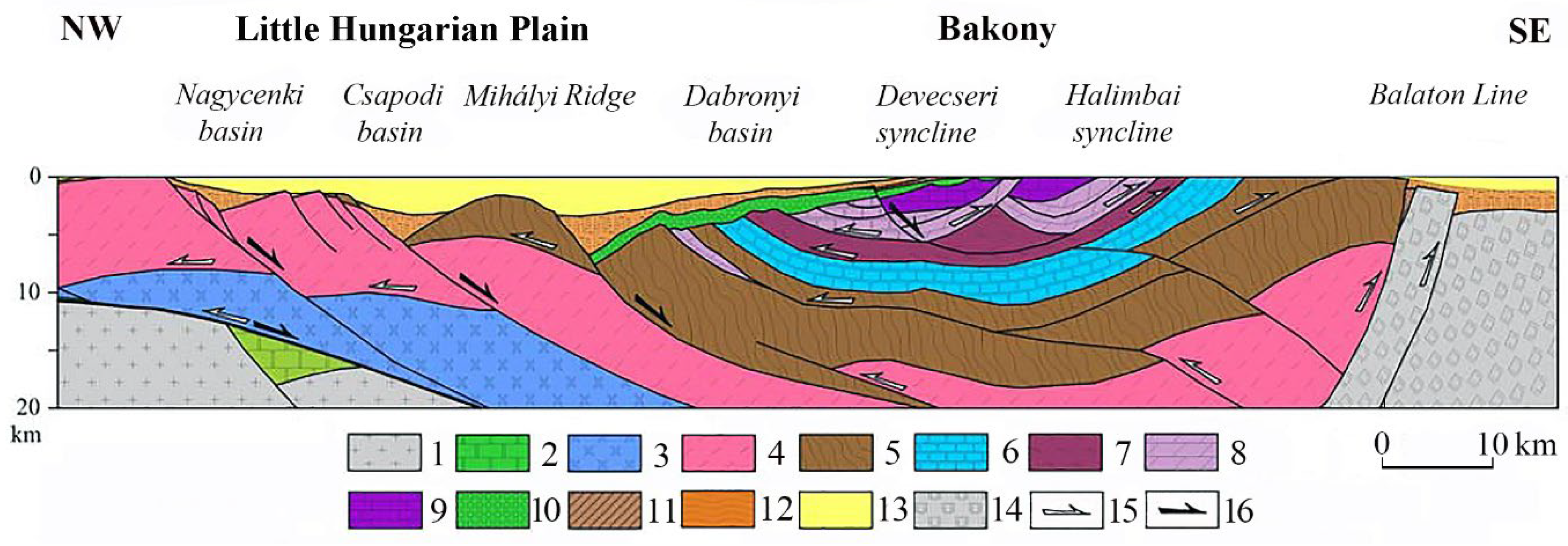
Their main constituting rock is the Triassic main dolomite (Main Dolomite Formation), and its thickness exceeds 1500 m [21]. In the Bakony Region, their bedrock is Veszprém marl (Veszprém marl formation) which constitutes a syncline with the underlying beds here [20] (Figure 4). The main dolomite is overlain by Triassic, Dachstein, Jurassic, Cretaceous and Eocene limestones in patches [20,22,23,24]. Young formations of the mountain margin are middle-Miocene limestones (Lajta limestone formation, Tinnye limestone formation, and Pliocene and Pleistocene calcareous sinters in the Dunazúg Mountains [23,24,25,26,27,28]. Non-karstic rocks also occur in the mountains and thus, lower Oligocene marl (Buda Marl Formation), Oligocene sandstone (Hárshegy sandstone formation) and clay (Kiscell clay formation) in the Dunazúg Mountains, Middle Oligocene-Lower Miocene delta gravel (Csatka Gravel Formation) in the Bakony Mountains, the Gerecse Mountains [20,23,26] and Pleistocene loess are widespread.
Figure 4. Geological profile [[20], modified]. 1. European upper crust, 2. European autochton Mesozoic (carbonate beds), 3. Penninic (metamorphic rocks), 4. lower, upper and Austroalpine Paleozic (limestones, metamorphic rocks), 5. uppermost Austroalpine Palozoic (limestones, metamorphic rocks), 6. lower, Middle Triassic (marl, sandstone, dolomite, and limestone), 7. Veszprém marl, 8. main Dolomite, 9. Dachstein and Kardosréti limestone, 10. Gosau beds, 11. Paleogenic beds (limestone, clay, and sandstone), 12. Lower- and Middle-Miocene beds (gravel), 13. Upper-Miocene beds (limestone, sandstone, and clay), 14. Paleo Mezozoic of dinaric type (middle-Hungarian main unit), 15. Mesozoic overthrusts and 16. Miocene dip faults.
Hydrology 10 00145 g004
Jurassic, Cretaceous, and Eocene limestone may be disrupted by impermeable beds or beds with bad permeability, particularly in the Bakony Region, and thus by the mineral silica and various rocks such as silica, clay, clayey limestone, marl, calcareous marl, abrasion pebble, and coal measures [29].
In the neighbourhood (Visegrád Mountains) of the Dunazúg Mountains (Pilis Mountains and Buda Hills), andesite volcanism took place in the Middle Miocene [30]. In the southern part of the Bakony Region, basaltic volcanism happened at the end of the Pliocene [31,32].
The karst of the Transdanubian Mountains (particularly in the case of the Dunazúg Mountains) was influenced by a significant heat effect. The heat may have been of a magmatic or heat flux origin [6]. Stegena et al. [33] explained the high heat flux with the elevated upper mantle and by the presence of the thinned-out continental crust.
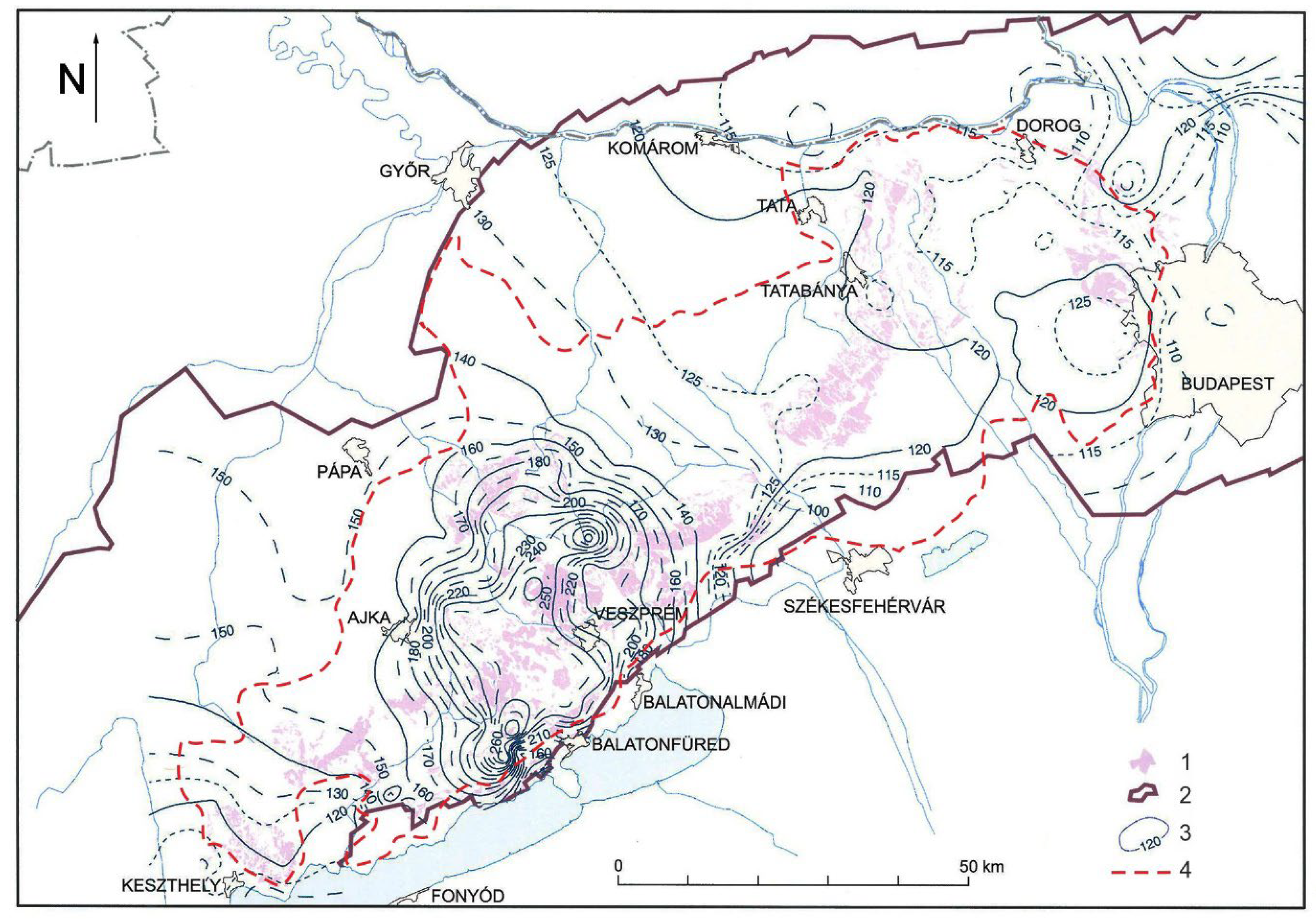
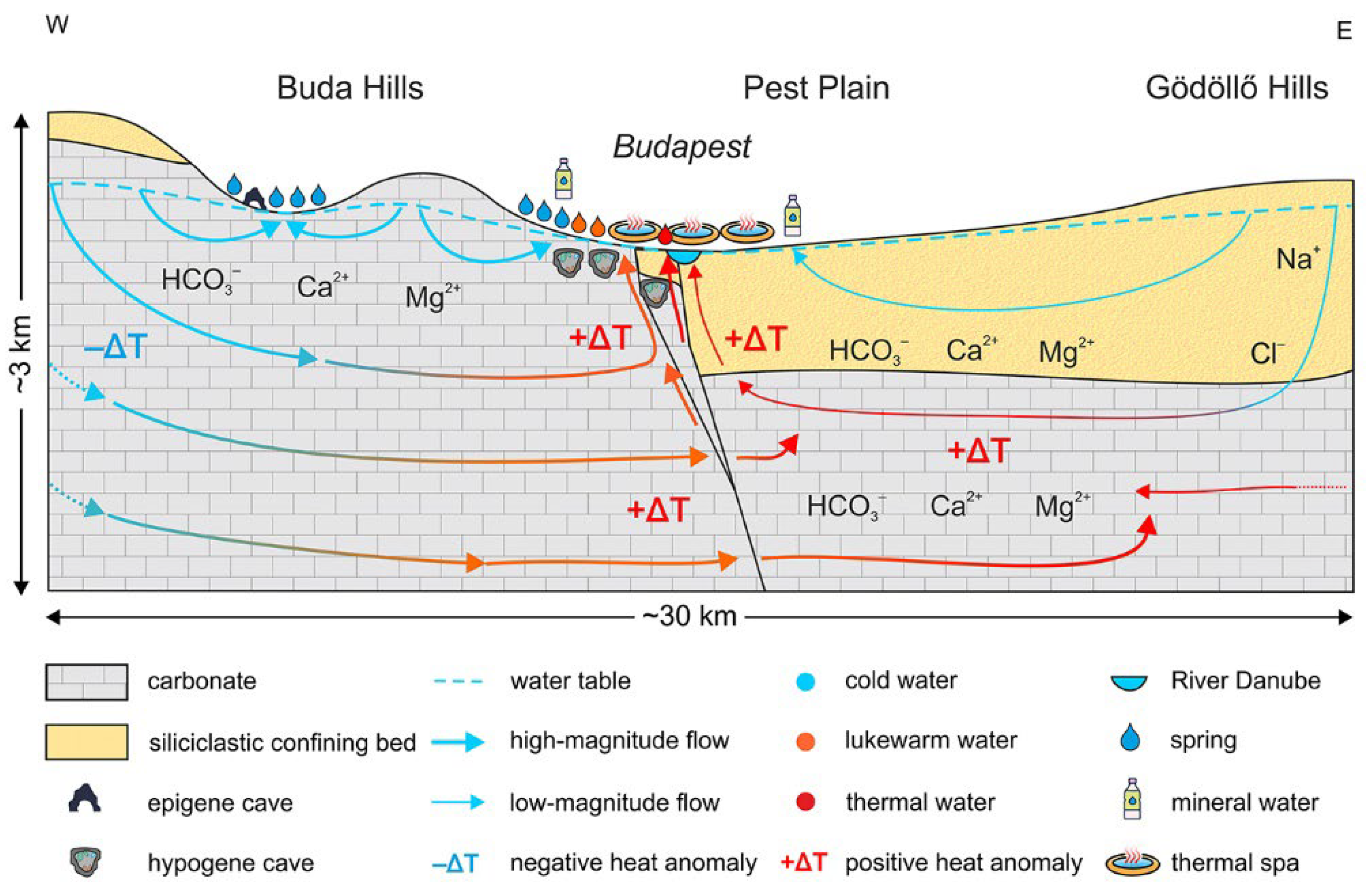
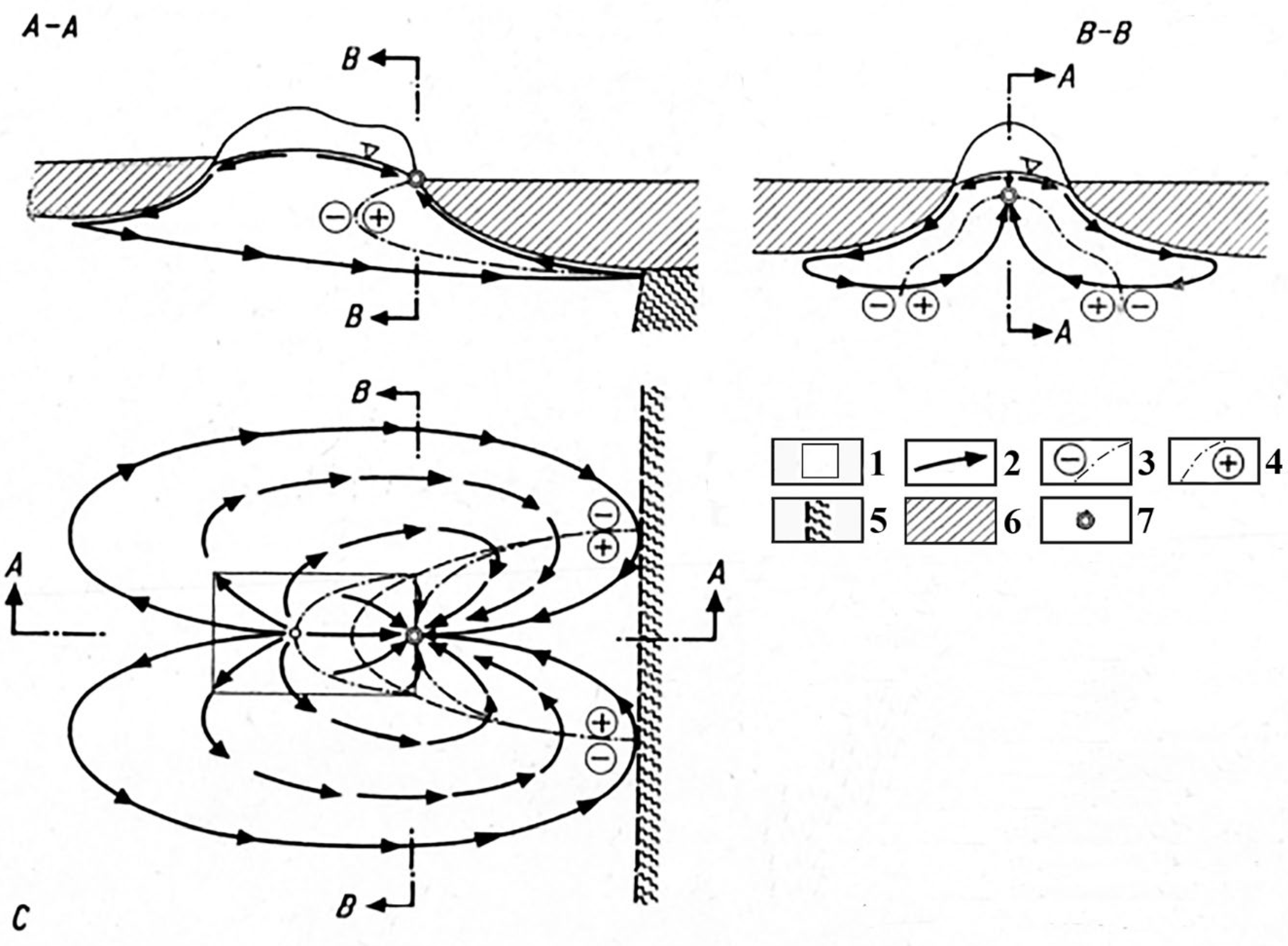
The uniformly developed karstwater of the mountains (Figure 5) is stored in the main dolomite. Preceding karstwater extractions, it emerged not only in karst springs, but also fed karst marshes and karst lakes (Lake Balaton) and flowed into the fill of the basins [1,2]. However, it is also transmitted into the River Danube [8,34,35], and the basin sediments of its environs [36] (Figure 6). The hypogene branch of regional flow was studied in the Buda Hills in a detailed way [6,37] (Figure 7, Figure 8 and Figure 9). The flow conditions of the karstwater of the mountains can be well-described with a three-dimensional model [38] (Figure 9). At some places, the warmed-up water of basin sediments flows into the karstwater [6,38].
The value of the reciprocal gradient is lower in Hungary and thus, in the Transdanubian Mountains than the average in the world. This great temperature anomaly can be explained by the great heat flux which can be traced back to the lower crust with a thickness of 5–8 km, the upper mantle of the upper position and the former magmatic activity that is the result of the latter [33]. The locally different values of heat flux result in the fact that the geoisotherms are not parallel to the surface. On the other hand, they form depressions due to the cooling effect of the karstwater in the karst areas.

3. Methods

Geoisotherm maps were used for our studies. The necessary temperature data were obtained from exploration wells. In the area of Hungary with an extension of 93 km2, more than 10.000 drillings went transversely across the Pannonian features and more than 1000 went transversely across the Miocene or older features. Data processing was carried out within the framework of the project “Geothermal survey of Hungary as regards of the Hungarian Energy & Utilities Regulatory Agency Geothermal projects”. Geoisotherm maps can be constructed for the area of Hungary with the application of the same temperature data. Thus, maps of the geoisotherms of 30, 50, 60, 70 and 90 °C were made.
With the help of geoisotherm maps of 50 °C and 90 °C along profiles (Figure 10 and Figure 11), horizontal specific temperature values were calculated between the studied karst area and the bordering basins. The method of calculation is described in Figure 12. The value of the horizontal specific temperature is the average temperature increase belonging to 1 km from the karst into the direction of the bordering basin. The temperature of site C was determined, the depth of which is the same as the depth of site A. For this, the temperature of site B that is situated below site C was used and is the same as the temperature of site A. The quotient of the depth difference between sites C and B and the reciprocal gradient gives the temperature of site C (the reciprocal gradient was calculated from the depth differences of isotherms of 90 °C and 30 °C, taking into consideration a temperature difference of 60 °C, for the Bakony Region and the Buda Hills). The temperature of site C can be calculated from the temperature difference. The temperature difference corresponds to the temperature difference between the two sites with the same depth (A and C). The quotient of the temperature difference between the two sites and the distance between them gives the horizontal specific temperature (Figure 12).

4. Results

The calculations were made along profiles using geoisotherm maps of 50 °C and 90 °C (Figure 10 and Figure 11). The horizontal distance of sites A and B (d), and the depth difference of sites B and C (h) can be calculated in two ways. Values d and h are given for the bisector distances of adjacent geoisotherms, for the central points of closing geoisotherm lines (their mark on the map is x) or between the points situated on the corresponding geoisotherms (their mark on the map is ο). These values can also be the same or different. Therefore, along the profiles, 2-2 horizontal specific temperature values can be calculated (Figure 10 and Figure 11 and Table 1).
Hydrostatic pressure values belonging to various altitude differences were also calculated (Table 2). This value is nearly 20 Mpa at a depth of 1450 m at Hévíz measuring from a surface elevation of the karst of 500 m (thus, with an elevation difference of 2000 m).
It can be established that based on geoisotherm maps, there are differences in the mountains regarding the depth distribution of temperatures. Due to the different density and depth of different geoisotherms, the horizontal specific temperature is different in various parts of the mountains. In the Bakony Mountains, there is a greater temperature difference compared to its environment than in the Buda Hills in the case of geoisotherms of 90 °C (Figure 11). In case of geoisotherms of 50 °C, the differences are large or larger in the Buda Hills and Gerecse Mountains as well (Figure 10). Reciprocal gradients are also different. While in the area of the Bakony Mountains the reciprocal gradient had a value of 25 m between depth with temperatures of 30–90 °C, in the Buda Hills, where the hypogene branch is the most intensive in the Transdanubian Mountains, the value of the reciprocal gradient was 23.83 m in the case of the same depths. Lenkey et al. [40] gives a value of 20 m/°C for the reciprocal gradient for the latter.
It can also be established that there is a relationship between the flow directions of the karstwaters of the Transdanubian Mountains and the values of horizontal specific temperatures.
According to the data of Table 1, outflow takes places at sites where the value of horizontal specific temperature is 0.4 °C (according to method a) or lower than 0.6 (based on method b). Partial upwelling occurs at places where this value is between 0.6 and 0.8 (based on method a) or between 1.0 °C and 2.0 °C (based on method b). It has to be noted that at Tapolcafő (profile J-J′), partial upwelling occurs in spite of the fact that the horizontal specific temperature is 2.08 °C. Upwelling takes place at sites where the horizontal specific temperature is 2.0 °C or higher, but this value may exceed 7 °C (according to method b) in the Buda Hills.
Table 1. Horizontal specific temperatures between the mountains and the floor of the karstic basin.
ProfileMountainsTemperature
(°C)
Reciprocal Gradient
[m/°C]
Horizontal Specific Temperature (°C/1 km)Direction of Water MotionWater Temperature of Karst Springs
Method aMethod b
A-A′Bakony Mountains
(Hévíz)
90250.831.98upwelling40 °C
[41]
B-B′Bakony Mountains90250.370.35outflow-
C-C′Bakony Mountains90250.290.58outflow-
D-D′Bakony
Mountains
90250.791.06partly upwellingTapolcafő spring 18.5 °C [2]
E-E′Bakony Mountains
(Tapolca)
90250.670.73partly upwellingin a cave with a temperature of 18–20 °C-os at a depth of 152 m 42 °C [42]
H-H′Bakony Mountains, Keszthely Mountains
(Hévíz)
50250.821.40upwelling40 °C
J-J″Bakony Mountains (near profile B-B′)50250.622.08partly outflowTapolcafő spring 18.5 °C [2]
F-F′Buda Hills
(Budapest)
9023.330.230.42?between 17–64.75 °C
[43]
G-G′Buda Hills
(Budapest)
5023.333.797.21upwelling
Method a: between the bisectors of isotherms, or in the centre of closing isotherm (its mark on the map is x); Method b: on the isotherm (its mark on the map is ο); ? uncertain.
Table 2. Hydrostatic pressure at various depth differences.
Depth Difference (m)Hydrostatic Pressure (Mpa)
500 m4.905
1000 m9.911325
1500 m14.816325
2000 m19.721325
2500 m24.626325
3000 m29.531325
At sites of upwelling, where karst springs with a high temperature occur, the horizontal specific temperature is greater (Table 1). The reason for high or higher values is that geoisotherms with the same values are at lower and lower depths towards the bordering basin. However, these values are lower at sites with partial upwelling; the water temperature of springs is lower (profile D-D′). Thus, at the Tapolcafő spring near the settlement of Pápa, the temperature of the spring is 18.5 °C, and at the Gánti spring in the Vértes Mountains this value is 16.0 °C [2]. These water temperatures refer to the fact that partial upwellings of a lower degree also occur at the outflows, which can be traced back to the higher horizontal specific temperature. Thus, for example, in profile D-D′ near which Tapolcafő spring is located these values are 0.79 °C and 1.06 °C. Horizontal specific temperatures are even lower at sites where no springs with a higher temperature occur or where there is a lack of springs (profiles B-B′ and C-C′).
It has to be mentioned that great horizontal specific temperatures occur at sites where geoisotherms are densely aligned at the interface of the mountains and the basin, but there is no upwelling or it is weak, for example along profile J-J′. However, if the larger distance is taken into consideration for the calculation of horizontal specific temperature (Table 1), the horizontal specific temperature is lower. The explanation for this is that farther from the mountains, the isotherm of 50 °C is situated at a depth of 1100 m and thus, geoisotherms are rarer farther from the mountains.

5. Discussion

The water moving downwards gravitationally cools down its environment, which is also described in Figure 11 and Figure 12. Therefore, the fluid flows towards the margin of the mountains to the effect of hydrostatic pressure. Here, where the cooling effect of the environment is not effective or it is effective to a small degree, it becomes warm. The degree of warming up depends on the degree of horizontal temperature growth in the surrounding area.
The upwelling of water, if it originates from karstic mountains, is caused by a density decrease (which depends on temperature) and also by hydrostatic pressure (in karstified rocks). Due to hydrostatic pressure, the water enters the karst and flows laterally, and during this process it becomes warmer to a different degree because of different horizontal specific temperatures.
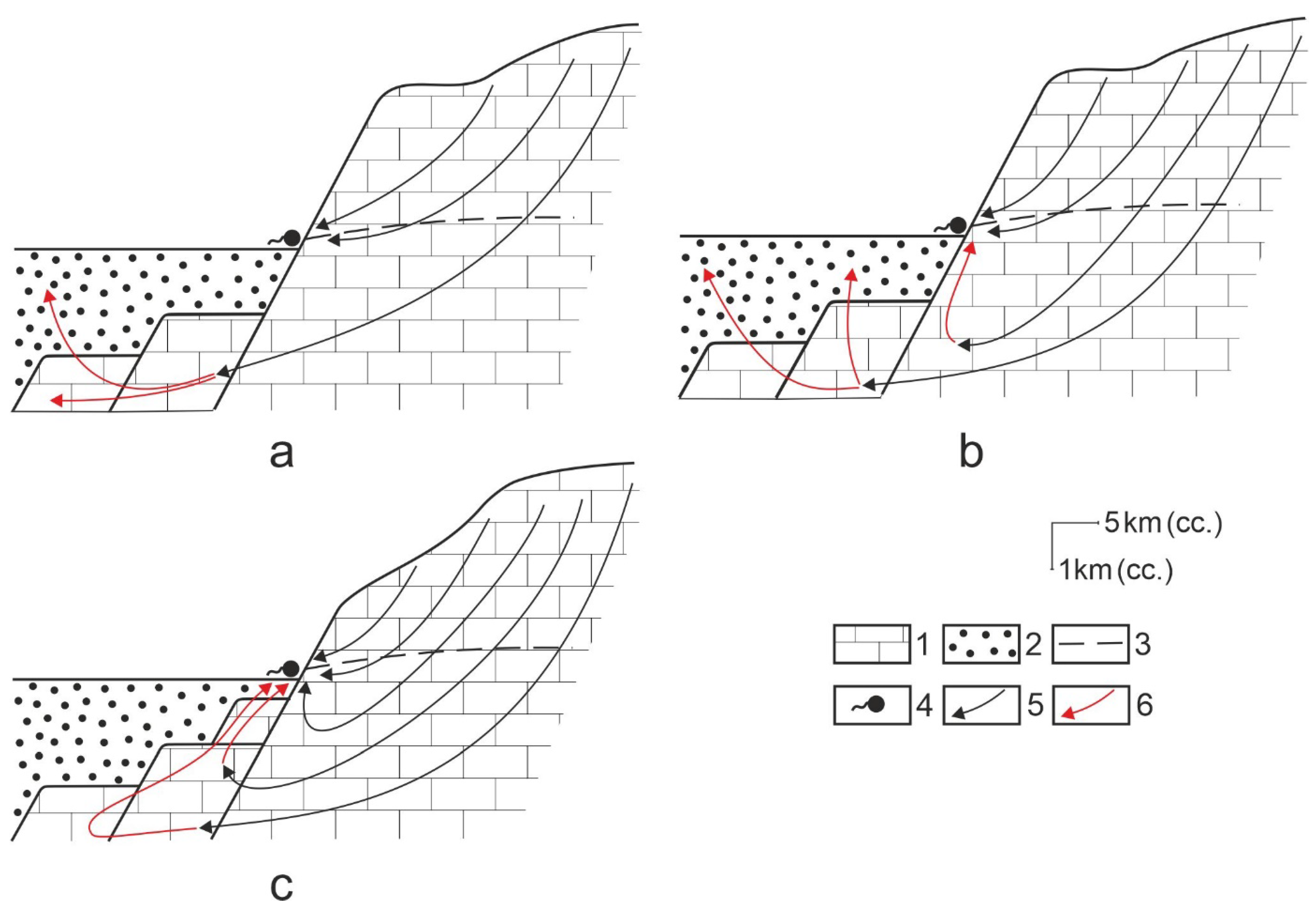
The larger the value of horizontal specific temperature, the faster, and the better the water leaving the karst is at becoming warmer. The faster it becomes warmer, the greater the chance for the water to flow upwards in the karstic rock and not to enter the basin sediments; thus, the effect of hydrostatic pressure is also valid. Upwelling is favoured if the sediment is not too thick at the margin of the mountains or if the hydrostatic pressure is large. In this case, the pressure (and the lifting power that originates from density decrease) is able to induce the water flow through the thin superficial deposit (Figure 13a and Figure 14c).
At sites where the horizontal specific temperature is of lower degree, the basin sediment is thicker, and the hydrostatic pressure allows the water to move laterally which does not become warm since it is situated inside the karst. The character of the flow of the surrounding basin and thus its complexity depends on the basin structure [44]. The fault structure of the basin can particularly influence flow characteristics. The outflow, slowly warming up water, moves in the karstic floor. There is a greater chance for the fluid to go deeper and farther from the karst if the subsidence of horsts is great in the basin and thus, it may reach a thicker superficial deposit. The effect of hydrostatic pressure on the fluid stops and the water is not able to flow upwards (or thus, towards the mountains, Figure 13b).
The significance of hydrostatic pressure is indicated by the fact that at sites where no karstic rock occurs in the floor of the bordering basin such as in the areas that border the mountains from the SE (Transdanubian Hills, Mezőföld), no upwelling occurs in spite of the fact that through flow also takes place here into the bordering basin [8,35].
Among the regional flow systems of the Transdanubian Mountains, there occur ascending flows (hypogene branch), formerly ascending flows (paleo hypogene branch), and flows of the outflow type (Figure 3 and Figure 14). Ascending flows are in the Buda Hills and Keszthely Mountains (Hévíz). Caves influenced by the heat effect and freshwater limestones of hydrothermal origin are evidence of paleo hypogene branches. Such branches occur in the Pilis Mountains, for example the Sátorkőpuszta Cave [11]. The calcareous sinters of hydrothermal origin of the Gerecse Mountains also refer to this [28]. The paleo hypogne branch can be detected along Lake Balaton from the Keszthely Mountains to Balatonfüred. Here, caves influenced by the heat effect such as the Cserszegtomaj Caves [45], the Lóczy Cave in Balatonfüred [46], and the spring cones of the Tihany Peninsula [47,48] refer to former upwelling of warm water. Two varieties of outflow can be distinguished. One of them is directed towards the karstic floor of the Little Hungarian Plain, while the other flow is that which takes goes to the non-karstic rocks of the area bordering the Bakony Mountains and Vértes Mountains from SE.
The heat distribution of the karst area and the surrounding basin are given by numbers of the horizontal specific temperature controls not only in the flow direction, but other characteristics of the fluid too. In several karst areas, no significant upwelling develops (or no upwelling develops at all) as a result of inadequate heat distribution or low heat flux. Such karst areas can be mentioned from Germany, Switzerland, Austria and the British Islands [14]. As a result of the above things, lower water temperatures occur for example where there are springs with temperatures of 12–17 °C and 17–21 °C at Stuttgart or the water does not reach the surface as in Unterhaching [14]. According to water temperature data, at Derbyshire and Stuttgart the structure of upwellings resemble the best flow structures that developed along the profiles of J-J’ and E-E’ in the Transdanubian Mountains.
Horizontal specific temperature affects the quantity and composition of the dissolved material of the ascending fluid, rock porosity and mineralisation (however, these are also dependent of geological structure). In the Buda Hills where the horizontal specific temperature may be higher than 7, mineralisation is relatively significant [49,50], while at the upwelling of the Keszthely Mountains, this value is 0.83 °C and 1.98 °C and no mineralisation takes place here. The difference is not only manifested in mineralisation, but also in the appearance of the large labyrinth caves of the Buda Hills [11]. Caves of this type are absent in the Keszthely Mountains. These differences cannot be explained by rock composition since the geological structure of the two mountains is the same. It can only be explained by more intensive upwelling and a higher temperature at the Buda Hills.
In the Guadalupe Mountains (USA), significant mineralisation can be detected [51,52,53], which can be explained by the hypogene branch that developed at the interface of the mountains and the surrounding basin. Several large labyrinth caves developed in the mountains [16], which can also be traced back to the intensive upwelling in the Buda Hills. These characteristics (mineralisation and cavity formation of a significant degree) refer to the high horizontal specific temperature.
At the ascending branch, cavity formation can be traced back to different reasons. In the Buda Hills, this reason is metamorphic CO2 [54], while in the Guadalupe Mountains, it is H2S [16]. The cavity formation of other karst areas such as some karst areas of Brazil and China can also be explained by the effect of H2S [16,55]. At the ascending branch, the cavity formation of the mixing corrosion origin (Buda Hills, the foreland of the Caucasus) may also be significant [16].
Heat distribution also influences the extension of the upwelling. In the southern margin of the Bükk Mountains (Hungary), upwelling is present in the whole extension of the mountains [8]. This is possible because the same geoisotherms (particularly those of 30 °C and 50 °C) are present in the total extension of the mountains.

6. Conclusions

In the Transdanubian Mountains, upwelling takes place at sites where the temperature difference is large between the karst and the bordering basin. In other words, the depth difference between the same geoisotherms is large and the same geoisotherms are closer to the surface in the area of the basin. Therefore, the horizontal specific temperature is larger than 0.5 °C (taking into consideration distances between or within isotherms), or larger than 2 (in the case of distances of sites situated on the isotherms), and the geoisotherm of 50 °C is closer to the surface than 500 m. Its value is extremely different at various parts of the mountains, and there may also be twentyfold differences. Horizontal specific temperatures may be different in different karst areas depending on the heat environment and geological structure of the area. Depending on its degree, the proportion of upwelling and outflow changes at various sites. At a given site, the intensity of upwelling is affected by the value of the reciprocal gradient, the depth distribution of geoisotherms, the depth pattern of the karstic floor of the basin (which is determined by structure), and the thickness of basin sediments at the interface of the mountains and the basin and near it. Upwelling may be triggered by temperatures belonging to areas of different depths. At Hévíz, a depth with a temperature of 90 °C is determinant, while at the Buda Hills a depth with a temperature of 50 °C is influential.

Author Contributions

Conceptualization, methodology, software, validation, formal analysis, investigation, resources, data curation, writing—original draft preparation, writing—review and editing, visualization, supervision, project administration, funding acquisition, M.V. and K.P. All authors have read and agreed to the published version of the manuscript.

Funding

This research received no external funding.

Data Availability Statement

Data supporting reported results are available in previous works.

Conflicts of Interest

The authors declare no conflict of interest.

References

  1. Szádeczky-Kardos, E. A Dunántúli középhegység karsztvízének néhány problémájáról (On some problems of the karst water of the Transdanubian Mountains). Hidrol. Közlöny 1941, 21, 67–92. (In Hungarian) [Google Scholar]
  2. Papp, F. Dunántúl karsztvizei és a feltárás lehetősége Budapesten (The karstwaters of Transdanubia and the opportunity of exploration in Budapest). Hidrol. Közlöny 1942, 21, 146–196. (In Hungarian) [Google Scholar]
  3. Keszler, H. Barlangok Mélyén (at the Bottom of Caves); Franklin Társulat: Budapest, Hungary, 1936; 134p. (In Hungarian) [Google Scholar]
  4. Pávai Vajna, F. A forró oldatok és gőzök-gázok szerepe a barlangképződésnél. (The roles of hot solutions and steams and gases in cave development). Hidrol. Közlöny 1930, 10, 115–122. (In Hungarian) [Google Scholar]
  5. Jakucs, L. A hévforrásos barlangkeletkezés földtani és fizikai tényezői (Geological and physical factors of thermal cave genesis). Hidrol. Közlöny 1948, 140, 53–58. (In Hungarian) [Google Scholar]
  6. Kovács, J.; Müller, P. A Budai-hegyek hévízes tevékenységének kialakulása és nyomai (Origin and traces of hydrothermal activities in the Buda Range). Karszt Barlang 1980, 2, 93–98. [Google Scholar]
  7. Mádlné Szőnyi, J.; és Tóth, Á. Basin-scale conceptual groundwater flow model for an unconfined and confined thick carbonate region. Hydrogeol. J. 2015, 23, 1359–1380. [Google Scholar] [CrossRef]
  8. Mádl-Szőnyi, J.; Erőss, A.; Csondor, K.; Iván, V.; Tóth, Á. Hydrogeology of the Karst Regions in Hungary. In Cave and Karst Systems of Hungary; Veress, M., Leél Őssy, S., Eds.; Springer: Cham, Switzerland, 2022; pp. 137–160. [Google Scholar]
  9. Leél-Őssy, S. Caves in the Buda Mountains. In Landscapes and Landforms of Hungary; Lóczy, D., Ed.; World Geomorphological Landscapes; Springer: Cham, Switzerland, 2015. [Google Scholar] [CrossRef]
  10. Mádl-Szőnyi, J.; Pulay, E.; Tóth, Á.; Bodor, P. Regional underpressure: A factor of uncertainty in the geothermal exploration of deep carbonates, Gödöllő Region, Hungary. Environ. Earth Sci. 2015, 74, 7523–7538. [Google Scholar] [CrossRef]
  11. Leél-Őssy, S.; Virág, M. The Caves of the Northeastern Part of the Transdanubian Mountains. In Cave and Karst Systems of Hungary; Leél Őssy, V., Ed.; Springer: Cham, Switzerland, 2022; pp. 361–413. [Google Scholar]
  12. Klimchouk, A.B. Hypogene Speleogenesis: Hydrogeological and Morphogenetic Perspective Special Paper No 1; National Cave and Karst Research Institute: Carlsbad, NM, USA, 2007; 106p. [Google Scholar]
  13. Klimchouk, A.; Palmer, A.N.; De Waele, J.; Auler, A.S.; Audra, P. Hypogene Karst Regions and Caves of the World; Springer: Cham, Switzerland, 2017. [Google Scholar]
  14. Goldscheider, N.; Mádl-Szonyi, J.; Erőss, A.; Schill, E. Review: Thermal water resources in carbonate rock aquifers. Hydrogeol. J. 2010, 18, 1303–1318. [Google Scholar] [CrossRef] [Green Version]
  15. Veress, M. Hydrological Characteristics of the Bakony Region (Hungary). Eng 2023, 4, 581–601. [Google Scholar] [CrossRef]
  16. Ford, D.C.; Williams, P.W. Karst Hydrogeology and Geomorphology; John Wiley & Sons Ltd.: Chichester, UK, 2007. [Google Scholar]
  17. Klimchouk, A. Speleogenesis-Hypogene. In Encyclopedia of Caves; White, B.W., Culver, D.C., Pipan, T., Eds.; Academic Press: Cambridge, MA, USA, 2019; pp. 974–988. [Google Scholar] [CrossRef]
  18. Kercsmár, Z.; Selmeczi, I.; Budai, T.; Less, G.; Konrád, G. Geology of the karst terrains in Hungary. In Cave and Karst Systems of Hungary; Veress, M., Leél-Őssy, S., Eds.; Springer: Berlin/Heidelberg, Germany, 2022; pp. 63–116. [Google Scholar]
  19. Schmidt Elegius, R. Geomechanikai szempontok a magyar mezozoós kratoszinklinálisok kialakulásához és főbb hegységszerkezeti vonásaik értelmezéséhez-Geomechanical point of views for the development of Hungarian Mesozoic cratogene synclines and for the interpretation of their main mountain structural characteristics. Foldt. Intez. Évkönyve 1961, 49, 747–758. (In Hungarian) [Google Scholar]
  20. Budai, T.; Konrád, G. Magyarország földtana (Geology of Hungary); Pécsi Tudományegyetem Pécs: Pécsi, Hungary, 2011; p. 102. (In Hungarian) [Google Scholar]
  21. Haas, J. A Budaörsi Dolomit Formáció, Fődolomit Formáció, Kösseni Formáció (The Budörs Dolomite Formation, Main Dolomite Formation, Kössen Formation). In Magyarország Litosztratigráfiai Alapegységei; Haas, J., Ed.; Triász, Földtani Intézet kiadványa: Budapest, Hungary, 1993. (In Hungarian) [Google Scholar]
  22. Gyalog, L. Magyarázó Magyarország Fedett Földtani Térképéhez (az Egységek Rövid Leírása) 1:100,000 (an Interpretation to the Covered Geological Map of Hungary, a Short Description of the Units); Magyar Állami Földtani Intézet: Budapest, Hungary, 2005; 189p. (In Hungarian) [Google Scholar]
  23. Haas, J.; Hámori, G.; Jámbor, Á.; Kovács, S.; Nagymarosi, A.; Szederkényi, T. (Eds.) Geology of Hungary; Eötvös University Press: Budapest, Hungary, 2001; 317p. [Google Scholar]
  24. Haas, J. Geological and Tectonic Background. In Landscapes and Landforms of Hungary; Lóczy, D., Ed.; Springer: Cham, Switzerland; Heidelberg, Germany; New York, NY, USA; Dordhrecht, The Netherlands; London, UK, 2015; pp. 7–17. [Google Scholar]
  25. Császár, G.; Csereklei, E.; Gyalog, L. A Bakony-Hegység Földtani Térképe (Szerk.) (Geological Map of the Bakony Mountains); Magyar Állami Földtani Intézet: Budapest, Hungary, 1981. (In Hungarian) [Google Scholar]
  26. Korpás, L. A Dunántúli-Középhegység Oligocén-alsó-Miocén Képződményei (Oligocene-Lower Miocene Features of the Transdanubian Mountains); MÁFI Évkönyve 64; Magyar Állami Földtani Intézet: Budapest, Hungary, 1981; 142p. (In Hungarian) [Google Scholar]
  27. Scheuer, G. A Budai termálkarszt pilisi szakaszának karsztvíz-földtani fejlődése a negyedidőszakban mészképző források alapján (The karstic hydrological evolution of the Pilis part of the Buda Thermal Karst on the basis of lime-forming thermal springs in the Quaternary period). Hidrol. Közlöny 2007, 87, 45–52. (In Hungarian) [Google Scholar]
  28. Kele, S.; Bódai, B. Age, depositional environment and geochemistry of freshwater carbonates (travertine, tufa) from Hungary. In Cave and Karst Systems of Hungary; Leél-Őssy, V., Ed.; Springer: Cham, Switzerland, 2022; pp. 513–533. [Google Scholar]
  29. Deák, M. Magyarázó Magyarország 200000-es földtani térképsorozatához, L-33-XII. In Veszprém (an Interpretation to the 200,000 Geological Map Series of Hungary, L-33-XII. Veszprém); Magyar Állami Földtani Intézet: Budapest, Hungary, 1972; 271p. [Google Scholar]
  30. Korpás, L. A Visegrádi-hegység (The Visegrád Mountains). In Pannon Enciklopédia; Karátson, D., Ed.; Kertek: Budapest, Hungary, 2000; pp. 327–328. (In Hungarian) [Google Scholar]
  31. Lóczy, L. A Balaton környékének geológiai képződményei és ezeknek vidékek szerinti telepedése (The geological features of the surroundings of Lake Balaton and their regional distribution). In A Balaton Tudományos Tanulmányozásának Eredményei; I.K. Magyar Állami Földtani Intézet: Budapest, Hungary, 1913; 617p. (In Hungarian) [Google Scholar]
  32. Jugovics, L. A Déli-Bakony és a Balaton-Felvidék Bazaltterületei (Basalt Terrains of Southern Bakony and of Balaton Uplands); Földtani Intézet Évi Jelentése 1953-Ról; Budapest, Hungary, 1954; pp. 65–88. (In Hungarian) [Google Scholar]
  33. Stegena, L.; Géczy, B.; Horváth, F. Late Cenozoic evolution of the Pannonian Basin. Tectonophysics 1975, 26, 71–90. [Google Scholar] [CrossRef]
  34. Bodor, P.; Erőss, A.; Mádl-Szőnyi, J.; Czuppon, G. A Duna és a felszín alatti vizek kapcsolata a Rózsadombi megcsapolási területen (Interaction between the ground-water and the Danube at the Rózsadomb discharge area. Karsztfejlődés 2014, 19, 63–75. [Google Scholar]
  35. Tóth, Á.; Mádl-Szőnyi, J. Where Does the Drinking Water Come From?–Interrelationship between Surface Water and Groundwater in a Carbonate Area, Hungary; EGU2019-8902; Geophysical Research Abstracts; EBSCO: Munich, Germany, 2019; Volume 21, p. 1. [Google Scholar]
  36. Csepregi, I. A karsztvízkiemelés hatása a Dunántúli-középhegység vízháztartására (The effect of karst water extraction on the water balance of the Transdanubian Mountains). In Bányászati Karsztvízszint-Süllyesztés a Dunántúli-Középhegységben; Alföldi, L., Kapolyi, L., Eds.; Magyar Tudományos Akadémia, Földrajztudományi Kutatóintézet: Budapest, Hungary, 2007; pp. 77–112. (In Hungarian) [Google Scholar]
  37. Mádlné-Szőnyi, J.; Erőss, A.; Havril, T.; Poros Zs Győri, O.; Tóth, Á.; Csoma, A.; Rochini, P.; Mindszenty, A. Fluidumok, áramlási rendszerek és ásványtani lenyomataik összefüggései a Budai-termálkarszton. (Fluids, flow systems and their mineralogical imprints in the Buda Thermal Karst). Földt. Közlöny 2018, 148, 75–96. (In Hungarian) [Google Scholar] [CrossRef] [Green Version]
  38. Alföldi, L.; Lorberer, Á. A karsztos hévizek háromdimenziós áramlásának vizsgálata kút adatok alapján (A study of the three-dimensional flow of karst rocks based on well data). Hidrol. Közlöny 1976, 56, 433–443. (In Hungarian) [Google Scholar]
  39. Tóth, A. Magyarország geotermikus felmérése a Magyar Energetikai és Közmű-Szabályozási Hivatal geotermikus projektjei tükrében (Geothermal survey of Hungary as regards of the Hungarian Energy & Utilities Regulatory Agency Geothermal projects). Magy. Tud. 2019, 180, 1822–1833. (In Hungarian) [Google Scholar] [CrossRef] [Green Version]
  40. Lenkey, L.; Dövényi, P.; Horváth, F.; Cloetingh, S.A.P.L. Geothermics of the Pannonian basin and its bearing on the neotectonics. In Neotectonics and Surface Processes: The Pannonian Basin and Alpine/Carpathian System; Cloetingh, S.A.P.L., Horváth, F., Bada, G., Lankreijer, A.C., Eds.; Stephan Mueller Special Publication Series; European Geosciences Union: Munich, Germany, 2002; Volume 3, pp. 29–40. [Google Scholar]
  41. Plózer, I. A Hévízi-tó forrásbarlangjának feltárása. (Exploration of the spring caves of Lake Hévíz). Karszt Barlang 1977, 65–66. (In Hungarian) [Google Scholar]
  42. Plózer, I. Adalékok a Tapolcai-tavasbarlang kutatásához (Data on the research of the Tapolca Lake Cave). Karszt Barlang 1975, 15–18. (In Hungarian) [Google Scholar]
  43. Ilosvay, L. 1893. Available online: https://www.arcanum.com/hu/online-kiadvanyok/OMMonarchia-az-osztrak-magyar-monarchia-irasban-es-kepben-1/budapest-394E/budapest-asvanyos-vizei-es-furdoi-ilosvay-lajostol-3E53/?list=eyJmaWx0ZXJzIjogeyJNVSI6IFsiTkZPX0tPTllfT01Nb25hcmNoaWFfMSJdfSwgInF1ZXJ5IjogImJ1ZGFwZXN0LWFzdmFueW9zLXZpemVpIn0 (accessed on 31 January 2023).
  44. Audra, P.; Palmer, A.N. Research frontiers in speleogenesis. Dominant processes, hydrogeological conditions and resulting cave patterns. Acta Carsolog. 2015, 3, 44. [Google Scholar] [CrossRef] [Green Version]
  45. Kárpát, J. A Cserszegtomaji-kútbarlang (The well cave of Cserszegtomaj). Karszt Barlang 1982, 1, 35–40. (In Hungarian) [Google Scholar]
  46. Láng, S. A Bakony geomorfológiai képe (The geomorphology of the Bakony Mountains). Földrajzi Közlemények 1958, 6, 325–343. (In Hungarian) [Google Scholar]
  47. Hoffer, A. A Tihanyi-félsziget vulkáni képződményei (Volcanic formations of the Tihany Peninsula). Földt. Közlemények 1943, 73, 375–429. (In Hungarian) [Google Scholar]
  48. Kovács-Pálffy, P.; Kalmár SVeress, M. A tihanyi-félsziget algás eredetű forrásüledékeinek ásvány-kőzettani vizsgálata. (Mineralogical-petrographic analyses of spring deposits of algal origin on the Tihany Peninsula). Karsztfejlődés 2007, 12, 121–135. (In Hungarian) [Google Scholar]
  49. Poros, Z.; Erőss, A.; Mádl-Szőnyi, J.; Mindszenty, A.; Molnár, F.; Ronchi, P.; Csoma, A.É. Mixing of karstic and basinal fluids affecting hypogene cave formation and mineralization in the Buda Thermal Karst, Hungary. In Proceedings of the IMA 2010 20th General Meeting of the International Mineralogical Association, Budapest, Hungary, 21–27 August 2010; Zaharia, L., Kis, A., Topa, B., Papp, G., Weiszberg, T.G., Eds.; Földtani Társulat: Budapest, Hungary, 2010; Volume 6, p. 465. [Google Scholar]
  50. Poros, Z.; Mindszenty, A.; Molnár, F.; Pironon, J.; Győri, O.; Ronchi, P.; Szekeres, Z. Imprints of hydrocarbonbearing basinal fluids on a karst system: Mineralogical and fluid inclusion studies from the Buda Hills, Hungary. Int. J. Earth Sci. 2012, 101, 429–452. [Google Scholar] [CrossRef]
  51. Hill, C.A. Geology of Carlsbad Cavern and other caves in the Guadalupe Mountains, New Mexico and Texas. New Mex. Bur. Mines Miner. Resour. Bull. 1987, 117, 150. [Google Scholar]
  52. Hill, C.A. Sulfuric acid speleogenesis of Carlsbad Cavern and its relationship to hydrocarbons, Delaware Basin, New Mexico and Texas. AAPG Bull. 1990, 74, 1685–1694. [Google Scholar]
  53. Hill, C.A. Sulpur redox reactions, native sulfur, Mississippi Valley type deposits, and sulfuric acid karst, Delaware Basin, New Mexico and Texas. Environ. Geol. 1995, 25, 16–23. [Google Scholar] [CrossRef]
  54. Müller, P. A metamorf eredetű széndioxid karsztkorróziós hatása (The karst corrosion effect of metamorphic carbon-dioxide). Karszt Barlang 1971, 2, 53–56. (In Hungarian) [Google Scholar]
  55. Auler, A.S.; Smart, P.L. The influence of bedrock derived acidity in the development of surface and underground karst: Evidence from the Precambrian carbonates of semi-arid Northeastern Brazil. Earth Surf. Process. Landf. 2003, 28, 157–168. [Google Scholar] [CrossRef]
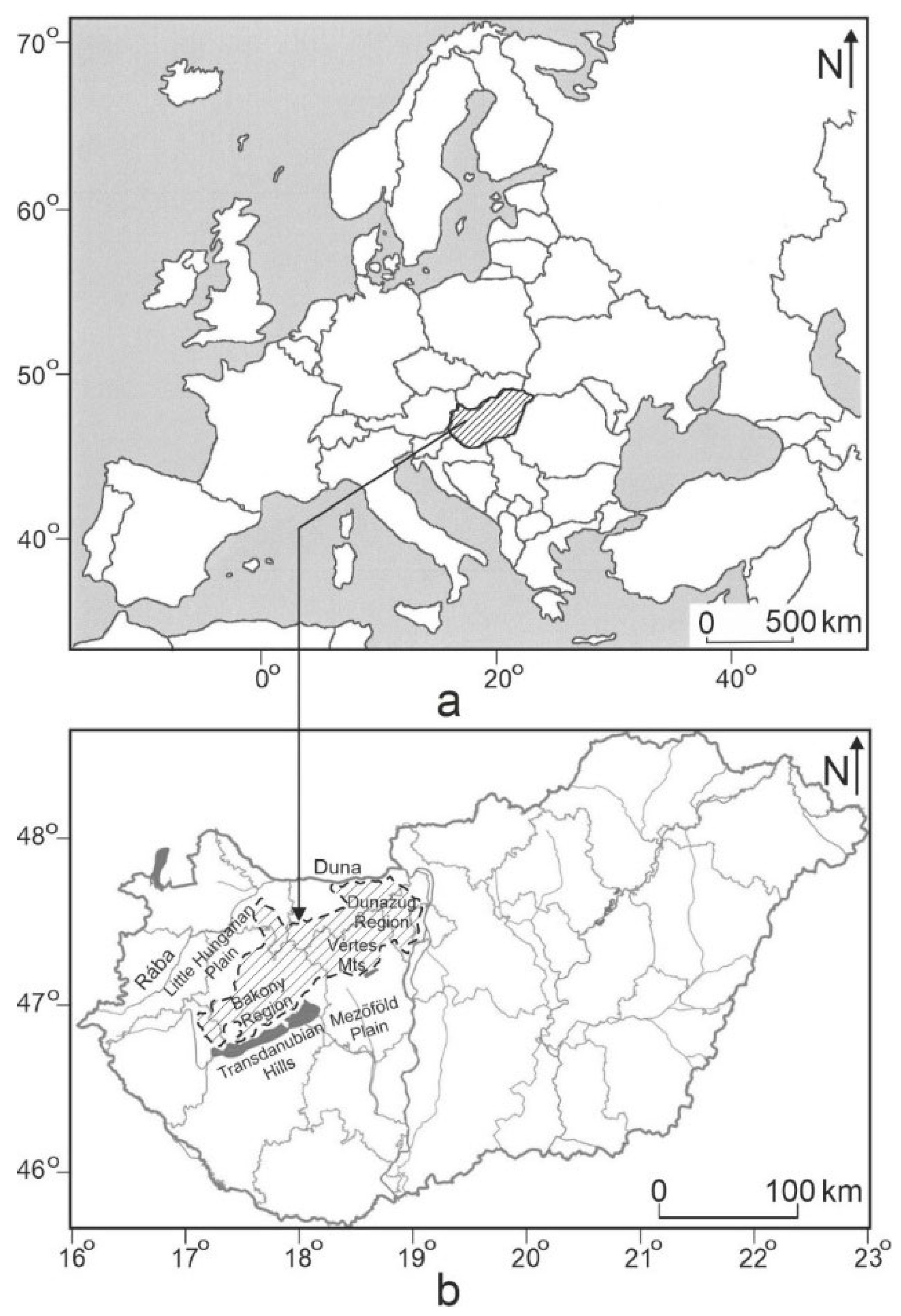
Figure 1. The Transdanubian Mountains and their main parts. (a) Hungary in Europe, and (b) the Transdanubian Mountains in Hungary.
Hydrology 10 00145 g001
Figure 5. Regional karstwater of the mountains [36]. Legend: 1. the infiltration area, 2. the boundary of karstwater storage, 3. altitude of the isoline of the karstwater level, and 4. the margin of the mountains.
Hydrology 10 00145 g005
Figure 6. The flow system of the karstwater along a profile of the NW–SE direction in the Bakony Region [8].
Hydrology 10 00145 g006
Figure 7. Model of upwelling in the Buda Hills where the source of supply is the mountains [6]. 1. Triassic dolomite, 2. Eocene limestone, 3. Oligocene clay, 4. Neogene sediment, 5. infiltration, 6. karstwater flow, 7. freshwater limestone, 8. fossil spring cave, 9. active spring cave, and 10. thermal spring (with a temperature of 60–120 °C).
Hydrology 10 00145 g007
Figure 8. Model of upwelling in the Buda Hills where the source of supply is the Buda Hills and the basin floor [8].
Hydrology 10 00145 g008
Figure 9. Three-dimensional flow model of karst hydrothermal waters [38]. 1. Karstic rock on the surface, 2. karstwater flow, 3. area of descending water motion (endothermic area), 4. area of ascending water motion (exothermic area), 5. subsurface boundary of karstified carbonate substratum, 6. impermeable and insulating basin sediment, and 7. thermal karst spring. A-A, lateral view; B-B, front view; C, plan view.
Hydrology 10 00145 g009
Figure 10. Depth distribution of the geoisotherm of 50 °C of Transdanubia [39]. Legend: 1. geoisotherm, 2. profile site, 3. measurement of distance from isotherm to isotherm, 4. measurement of distance between the bisectors of the band boundary or between the means of closing isotherm lines.
Hydrology 10 00145 g010
Figure 11. Depth distribution of the geoisotherm of 90 °C of Transdanubia [39]. Legend: 1. geoisotherm, 2. profile site, 3. measurement of distance from isotherm to isotherm, and 4. measurement of distance between the bisectors of the band boundary or between the means of closing isotherm lines.
Hydrology 10 00145 g011
Figure 12. Calculation of horizontal specific temperature at similar depths (but at site C this is corrected with the value of geothermic gradient). Legend: 1. basin sediment, 2. karst spring, 3. mountains, and 4. basin; h. depth difference of sites situated above each other (B and C), d. distance between read and calculated sites, hs. horizontal specific temperature, A. and B. sites with similar temperatures, but different depths, C. site whose depth is the same as the depth of site A, above site B, t1. temperature of sites A and B, and t2. temperature of site C (calculated).
Hydrology 10 00145 g012
Figure 13. Basin structure favouring upwelling (a), and basin structure less favourable for upwelling (b). Legend: 1. basin sediment, 2. karstic rock, 3. cold flow, 4. warm flow, and 5. karst spring.
Hydrology 10 00145 g013
Figure 14. Theoretical flow types in the mountains. (a). Outflow, (b). partial upwelling, (c). upwelling, 1. karstic rock, 2. basin sediment, 3. karstwater level, 4. karst spring, 5. flow of cold water, 6. flow of warmed-up water.
Hydrology 10 00145 g014
Disclaimer/Publisher’s Note: The statements, opinions and data contained in all publications are solely those of the individual author(s) and contributor(s) and not of MDPI and/or the editor(s). MDPI and/or the editor(s) disclaim responsibility for any injury to people or property resulting from any ideas, methods, instructions or products referred to in the content.