Article

Impacts of Climate Change on Groundwater in the Al-Badan Sub-Catchment, Palestine: Analyzing Historical Data and Future Scenarios

1
Department of Civil, Environmental, Architectural Engineering, and Mathematics, University of Brescia, 25100 Brescia, Italy
2
University School for Advanced Studies IUSS Pavia, 27100 Pavia, Italy
3
Department of Civil and Architectural Engineering, Faculty of Engineering and IT, An-Najah National University, Nablus P.O. Box 7, Palestine
*
Author to whom correspondence should be addressed.
Hydrology 2024, 11(10), 169; https://doi.org/10.3390/hydrology11100169
Submission received: 24 September 2024 / Revised: 8 October 2024 / Accepted: 9 October 2024 / Published: 10 October 2024

Abstract

:
Climate change is significantly impacting water resources, especially in arid regions. This study evaluates its effects on groundwater in the Al-Badan sub-catchment, Palestine, by analyzing hydroclimatic data from 1990 to 2020 and the future predicted climate change scenarios. Using the Mann-Kendall test and Sen’s slope estimator, a significant annual decline in annual precipitation of 125 mm and a temperature increase of 1.84 °C were observed, resulting in a spring discharge reduction of 1.2 MCM. Multiple linear regression analysis showed that a 10% increase in precipitation correlates with a 5% discharge increase, while a 1 °C rise in temperature results in a 2.3% discharge decrease. Future scenarios indicate significant changes: for 2040–2060, RCP2.6 forecasts average precipitation of 334.5 mm with temperatures at 18.5 °C, resulting in spring discharge of about 4.6 MCM. In contrast, RCP4.5 and RCP8.5 predict reductions in precipitation to 307.2 mm and 311.2 mm, respectively, with temperatures rising to 18.9 °C and 19.3 °C, leading to discharge declines to 4.2 MCM and 4.0 MCM. For 2080–2100, RCP2.6 anticipates 335.8 mm of precipitation and temperatures rising to 19.5 °C, resulting in average discharge of 4.5 MCM. RCP4.5 and RCP8.5 predict further declines in precipitation and discharge, underscoring the need for effective water management strategies.

1. Introduction

Climate change significantly affects water availability on both global and local scales through its influence on precipitation, air temperature, and other climate factors that impact water resources [1]. The Middle East, with 5% of the global population and only 1% of its freshwater, faces a severe water imbalance [2]. This issue stems from its arid climate, high demand, and inefficient use. Overexploited groundwater and pollution further complicate the situation. Human activities and anticipated local climate changes make this imbalance even worse, posing a significant threat to the availability and sustainability of water resources [3]. The Mediterranean region faces decreased precipitation and rising temperatures, increasing vulnerability and straining socio-economic and ecological balances [4,5]. Palestine’s strategic location in the Middle East makes addressing its water issues crucial for both regional stability and improving living conditions. Its position affects and is affected by neighboring countries, making effective water management essential for reducing conflicts over shared resources and enhancing local quality of life. Specifically, the West Bank serves as a critical area for assessing the effects of climate change. The climate of the West Bank is classified as semi-arid [6], characterized by irregular and limited precipitation, which presents challenges for water availability. At the same time, demographic projections for the Palestinian population, in specific the West Bank, indicate a population growth from 5.2 million to 7.2 million by 2030 [7]. Moreover, in the West Bank, an 8–10 mm reduction in monthly average precipitation is expected by the end of the century, indicating increased aridity and potential alterations in seasonal precipitation patterns [8].
In the West Bank, water availability is a critical concern due to limited resources, unequal access, and high demand. Groundwater is the main source of freshwater for the West Bank population, and around 50% of these underground aquifers have significantly depleted over the last 20 years [9]. Depletion is driven by over-extraction, pollution, and inadequate infrastructure [10]. Climate change significantly impacts groundwater resources in the West Bank, with reduced precipitation and rising temperatures leading to decreased groundwater recharge and altered discharge patterns [11]. Research highlights that these changes are exacerbating water scarcity and variability in groundwater levels, affecting water availability [12]. Adaptation strategies enhance water security and resilience through technology, policy, and community action [13]. The Faria Catchment, covering 320 km2 in northeastern West Bank, is crucial for water resources, agriculture, and economic stability [14]. Previous research in this catchment has covered a wide range of topics, providing insights into water resource dynamics, hydrogeology, and management challenges [15]. Climate change, altering precipitation patterns and intensifying droughts, has worsened conditions in the catchment, where studies assess the catchment’s vulnerability to meteorological droughts by examining precipitation, runoff, and historical droughts [16]. Other research suggests that strategic urban planning and infrastructure development in the Faria can mitigate the adverse effects of urbanization on water quality [17].
The Faria Catchment includes upper basins like Al-Badan and Al-Faria, and lower basins such as Al-Nahla and Al-Jiftlik, each essential for water management and agriculture [14]. The upper part of the Faria Catchment is especially important due to its higher population density and enhanced data accessibility [14]. Despite broad findings on climate change impacts in the West Bank, there is a critical need for localized studies to better understand specific sub-basins. This study will focus on the Al-Badan sub-catchment in the upper part of the catchment, as it is the beginning of the catchment and the most urbanized area with various human activities. The Al-Badan sub-catchment, covering 83 km2, is essential for its ecological, agricultural, and socio-economic value [18]. The water demand in Al-Badan is primarily covered by springs and groundwater wells. The increased water scarcity during droughts and the sensitivity to climate change, with rising temperatures and altered precipitation patterns, emphasize the significance of studying water availability in the sub-catchment. This study addresses the gap by focusing on the Al-Badan sub-catchment to provide detailed insights into how local trends in precipitation, temperature, and spring discharge are affected by climate change. The research has three main objectives:
  • Firstly, it analyzes trends in yearly precipitation, temperature, and total spring discharge at Al-Badan from 1990 to 2020 using the Mann-Kendall test with Sen’s slope estimator, a strong method for climate trend analysis [19,20].
  • Secondly, it quantitatively examines the statistical relationship between precipitation, temperature, and spring discharge using multiple correlation analysis, which is effective for understanding hydrological relationships. [21,22]. The residual analysis of the regression model will also be conducted to assess the model’s accuracy, and this correlation will be used for predicting future spring discharge.
  • Finally, the study integrates climate scenarios based on RCPs to predict future changes in precipitation and temperature and their impact on spring discharge for the periods 2040–2060 and 2080–2100. Climate scenarios based on Representative Concentration Pathways (RCPs) are used to model future changes in precipitation, temperature and their impact on water resources [23,24]. These objectives aim to understand Al-Badan’s climate and water patterns for sustainable management and adaptation.

2. Materials and Methods

2.1. Study Area

Al-Badan sub-basin is part of the upper Faria catchment. The Al-Badan sub-catchment, located in the northeastern West Bank, Palestine, as shown in Figure 1, covers 83 km2 and is home to around 47,662 people. As of 2018, it has a 1.94% annual population growth rate, affecting its environmental conditions [25]. The climate is arid to semi-arid, with rainy winters from November to March and dry summers from June to August. January is the coldest month (5 °C to 10 °C), and August is the hottest (18 °C to 38 °C). The Faria catchment is monitored by six rainfall stations: Nablus, Al-Fara, Taluza, Tubas, Tammun, and Beit Dajan. Nablus serves as the primary weather station, providing comprehensive weather data. The other stations are basic rain gauges measuring daily rainfall [26]. The best station to cover the Al-Badan sub-catchment is the Beit Dajan station. This is because it is geographically closest to the Al-Badan sub-catchment, providing more accurate and relevant rainfall data for that specific area. In Al-Badan, land use includes agriculture with irrigation, grasslands, olive plantations, terraced hillslopes, urban areas, and infrastructure. In Al-Badan sub-catchment, the springs vary widely in elevation, significantly influencing the area’s hydrological and ecological profile. The springs, listed in order of their elevation, are as follows: Dafna (DAQQAH) is the highest at 560 m, followed by Balata at 510 m. Es Sedreh (Sedrah) is next at 240 m, while Hamad and Baidah and Qdairah each have an elevation of 215 m. Jeser is situated at 170 m, Tabban at 160 m, and Al Subyan is the lowest at 130 m. This range of elevations across the springs affects water distribution and contributes to the diverse environmental conditions within the sub-catchment. The study focuses on analyzing the total discharge from the eight main springs in Al-Badan, which collectively release around 4 million cubic meters annually.

2.2. Data

The study’s data falls into three main categories. Firstly, the yearly precipitation data from 1990 to 2020 was collected at the Beit Dajan station. This station is the closest to the Al-Badan sub-catchment and provides the most accurate and relevant rainfall data since there are no gauges within the catchment itself. Monthly precipitation data from Beit Dajan has been converted to yearly data based on the hydrological year. Additionally, average annual temperature data for the same period was obtained from the Nablus station. This station is the only one in the Faria catchment with records of monthly average temperatures. The monthly data has been converted to a yearly basis [27]. Secondly, hydrological data was collected by obtaining the total annual discharge from eight springs in Al-Badan. Reports from the Palestinian Water Authority provide the total yearly discharge for all springs in the sub-catchment. This aggregated data approach is necessary because some springs have incomplete records, with gaps in data for certain years, making it challenging to analyze each spring individually. Therefore, the total springs discharge is used for consistency and accuracy [28]. Lastly, the study considered climate change impacts using future precipitation and temperature data from the Coordinated Regional Climate Downscaling Experiment (CORDEX) database [29]. The data, sourced from CORDEX, covers three RCPs (RCP2.6, RCP4.5, RCP8.5) for the periods 2040–2060 and 2080–2100. It uses the ICHEC-EC-EARTH global climate model and the RCA4 regional climate model, specific to the Middle East and North Africa (MNA-44i) domain.

2.3. Trend Analysis

Trend analysis is a statistical method that helps identify and understand long-term changes by detecting significant data patterns or shifts over time, whether increasing or decreasing [30,31]. Trend analysis in Al-Badan’s sub-catchment is key for water resource management as it predicts future water availability, identifies potential issues, and anticipates impacts from shifting climate patterns. It supports effective planning and enhances climate resilience. Mann-Kendall and Sen’s slope tests are statistical methods for trend analysis in data time series of yearly precipitation, temperature, and springs discharge at Al-Badan sub-catchment for 30 years. The Mann-Kendall test identifies whether a data series has a significant monotonic trend, either increasing or decreasing [32,33]. Meanwhile, Sen’s slope estimator quantifies the magnitude of this trend, providing a measure of the rate of change over time. Together, these methods offer a comprehensive analysis of trends in hydrological and climatic data. The data series for total yearly precipitation, average yearly temperature, and total yearly spring discharge were organized. Python libraries such as SciPy and PyMannKendall were used to calculate the Mann-Kendall test statistics (Z) and Tau (τ) statistics, which reveal the strength and direction of trends. To determine the significance of these trends, the p-value was compared to a threshold of 0.05; a p-value below this threshold indicates that the trend is statistically significant. Additionally, Sen’s slope estimator was calculated using Python libraries like NumPy and SciPy. This process involved sorting the data, computing pairwise differences, and finding the median of these differences to estimate the trend magnitude in the time series. The Mann-Kendall test statistic (S) is thus, calculated as follows in Equation (1):
S = i = 1 n j = i + 1 n s i g n x j x i
where, n is the total number of data points, xi and xj are the data values in time series i and j (j > i), and sign(xjxi) is the sign function calculated as in Equation (2):
s i g n x j x i = 1 ,   i f   x j x i > 0 0 ,   i f   x j x i = 0 1 ,   i f   x j x i < 0
The variance V(S) Is calculated as in Equation (3), Where n is the number of data points, m is the number of tied groups and ti is the number of ties to the extent of i. The standard normal test statistic Z is computed as in Equation (4):
V ( S ) = n n 1 2 n + 5 i = 1 m t I i i 1 2 i + 5 18
Z = S 1 V S ,   i f   S > 0 0 ,   i f   S = 0 S + 1 V S ,   i f   S < 0
Sen’s Slope Estimator test were evaluated based on Equation (5):
Sen’s   slope = m e d i a n   x j x i   j i   f o r   a l l   j > i

2.4. Correlation Analysis

Multiple correlation analysis is a statistical method used to examine the relationships between several independent variables and a single dependent variable, revealing their interactions and influence [34]. This method is essential in hydrology for understanding variables such as precipitation and river flow [35]. Studies have employed similar methods to predict river flow under climate change scenarios and estimate groundwater recharge using climatic variables [36]. Past research has also explored temperature and precipitation extremes in America [37], and groundwater levels in India [22]. This study employs multiple linear regression analysis to investigate the relationship between the total springs discharge and two primary climatic variables of precipitation (P) and temperature (T). This type of analysis is used due to the lack of data regarding groundwater levels and past land use, making it necessary to rely on available climatic data to predict spring discharge. The analysis is conducted using Python, employing its powerful libraries for data processing, statistical analysis, and visualization, specifically pandas, stats models, and matplotlib. The dataset includes annual records of precipitation, temperature, and spring discharge from 1990 to 2020. To account for potential nonlinear relationships, polynomial terms (P2 and T2) and an interaction term (P × T) are included in the regression model. This approach allows the model to capture more complex interactions between the variables. A multiple linear regression model is fitted to the data, producing an equation to predict spring discharge based on precipitation and temperature. This relation can be shown in Equation (6), where: Springs discharge (MCM) is the spring discharge in million cubic meters, P represents precipitation, T represents temperature, β0 is the intercept term, β1, β2 are the coefficients for the linear terms of precipitation and temperature, respectively. β3, β4 are the coefficients for the quadratic terms of precipitation and temperature, respectively. β5 is the coefficient for the interaction term between precipitation and temperature.
Springs discharge (MCM) = β0 + β1 × P + β2 × T + β3 × P2 + β4 × T2 + β5 × (P × T)
A 3D surface plot is generated to visualize the relationship between precipitation, temperature, and spring discharge, showing how variations in these variables affect discharge. The model’s effectiveness is assessed using the coefficient of determination (R2), and residual analysis is performed to evaluate accuracy and error distribution. This approach facilitates the creation of a predictive equation for future spring discharge based on anticipated changes in precipitation and temperature, offering valuable insights for water resource management in different climate change scenarios.

2.5. Climate Change Scenarios for the Period 2040–2060 and 2080–2100

RCPs are standardized climate scenarios introduced by the IPCC in its Fifth Assessment Report [38]. These scenarios project future greenhouse gas concentration pathways and are valuable tools for evaluating potential global and local climate impacts [39]. RCPs are a widely used tool in research, providing a standard framework for projecting future climate conditions and assessing water availability and climate change impacts [40]. This study is the first to apply Representative Concentration Pathways (RCPs) to the Al-Badan sub-catchment, analyzing their impacts on precipitation, temperature, and spring discharge. It uses RCP scenarios (RCP2.6, RCP4.5, RCP8.5) for the future periods 2040–2060 and 2080–2100 to evaluate how projected emissions will affect precipitation and temperature in the sub-catchment. Future annual precipitation and temperature data from these RCP scenarios were used to predict spring discharge in Al-Badan based on established relationships. The study then compares these predicted averages with historical data to assess changes. This comprehensive approach not only provides important insights into future hydrological conditions under different scenarios but also helps in crafting effective resource management strategies.

3. Results

3.1. Trend Analysis

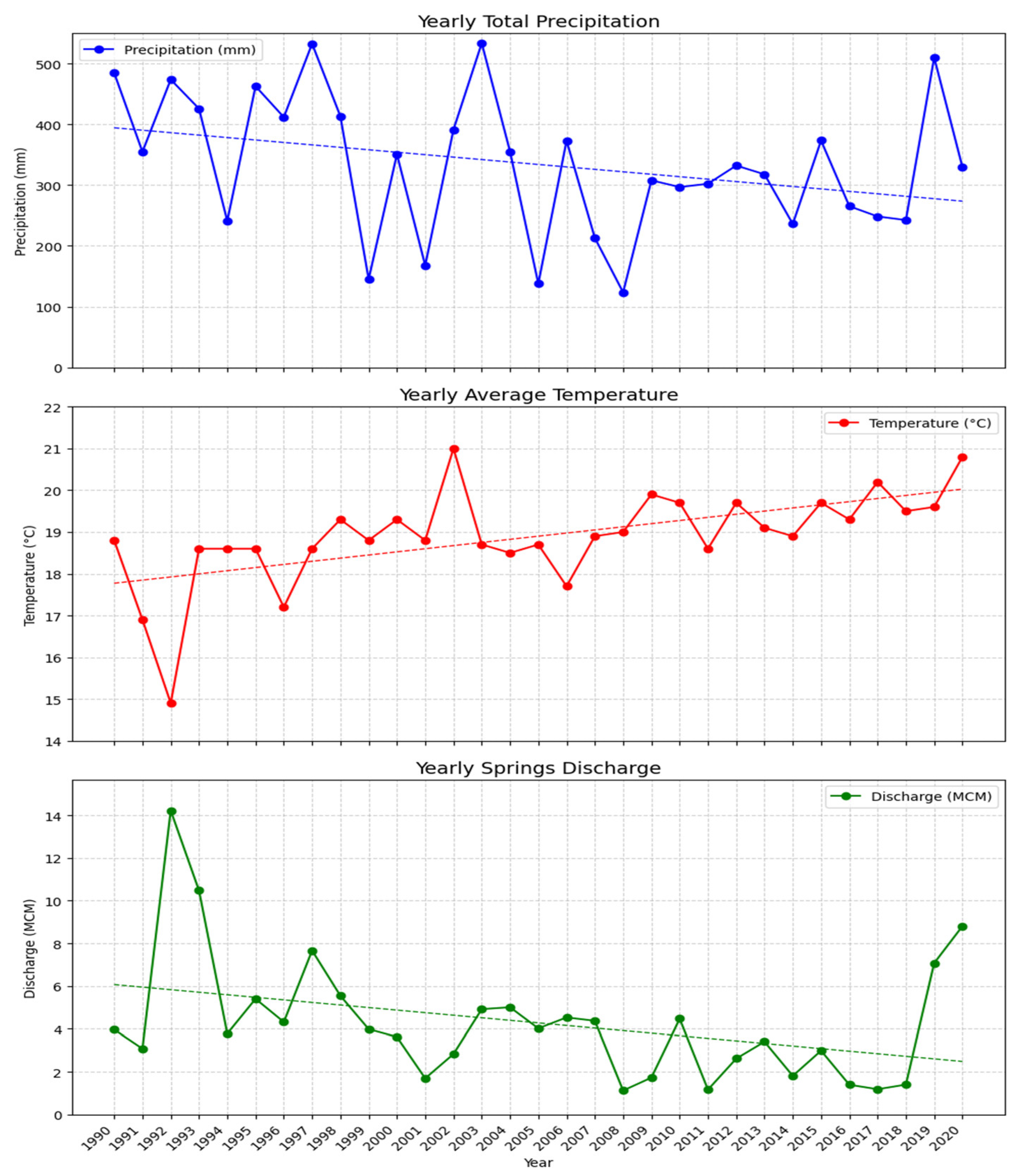
The Mann-Kendall test has been applied to assess trends in precipitation, temperature, and springs discharge in the Al-Badan sub-catchment over a 30-year study period. The Z-Statistic from this test measures the direction and strength of a trend, with positive values indicating an increase and negative values indicating a decrease. The p-value assesses the probability that the observed trend is due to chance, with values less than 0.05 suggesting statistical significance. Additionally, the Sen’s Slope estimator quantifies the magnitude of the trend per unit time. The average yearly precipitation is 334.12 mm, showing a statistically significant decline with a Mann-Kendall Z-Statistic of −2.01 and a p-value of 0.045. The Sen’s Slope estimate quantifies this trend as a decrease of 5.5 mm per year, totaling 165 mm over the study period. The average yearly temperature of 18.9 °C exhibits a significant increase, with a Z-Statistic of 3.858 and a p-value of 0.0001, indicating a rise of 0.061325 °C per year, amounting to 1.84 °C over 30 years. The average yearly springs discharge, at 4.3 MCM, shows a significant decrease with a Z-Statistic of −2.21 and a p-value of 0.027, accompanied by a Sen’s Slope estimate of −110,920 m3 per year.
These results, summarized in Table 1 and Figure 2, show that the Al-Badan sub-catchment is undergoing significant climate changes. The decline in precipitation, rise in temperature, and marked decrease in springs discharge together reflect a substantial shift in environmental conditions. The decrease in precipitation and rise in temperature are significantly reducing water availability from springs, which presents a serious threat to water security and ecosystem stability. In Al-Badan sub-catchment, reduced spring discharge impacts agriculture and drinking water, affecting local communities and wildlife. These changes are likely to lead to increased water scarcity, further stressing both human and ecological systems reliant on these water sources.

3.2. Correlation Analysis

The multiple linear regression analysis shows a significant relationship between springs discharge (MCM) and the independent variables: precipitation (P), temperature (T), their squared terms (P2, T2), and their interaction term (P × T). The resulting regression shown in Equation (7):
Springs discharge (MCM)= 133.16 + 0.03 × P − 14.34 × T + 3.73 × 10⁻⁵ × P2 + 0.397 × T2 − 2.25 × 10⁻³ × (P × T)
This model highlights significant relationships between springs discharge and the climatic variables of precipitation and temperature, including their squared and interaction terms. Precipitation positively influenced discharge, with each additional millimeter of precipitation resulting in an increase of 0.03 MCM in discharge. Conversely, temperature had a negative impact, where each degree Celsius increase led to a reduction of 14.34 MCM in discharge. The squared terms and the interaction term indicated a complex, non-linear relationship between these variables and spring discharge. The 3D surface plot visually validates the model, showing how precipitation and temperature impact spring discharge shown in Figure 3. The model explained 60% of the variability in spring discharge, as indicated by the R2 value of 0.6. Despite this, other factors such as land use changes, vegetation cover, soil moisture, groundwater levels, and human activities were not included due to data limitations. This equation will be used to project future spring discharge in the sub-catchment based on anticipated precipitation and temperature data from the RCPs, providing insights for future water resource management under changing climatic conditions.
Figure 4 shows the analysis of residuals which is important for validating the assumptions of the regression model and ensuring the reliability of the predictions. The residuals plot shows the residuals (errors between observed and predicted discharge values) against the index of observations. The plot shows that the residuals fluctuate around zero, indicating that the model does not systematically overestimate or underestimate the discharge values. However, there is a notable variation in the residuals, suggesting periods where the model’s accuracy varies. The histogram of residuals demonstrates the distribution of residuals. The distribution appears to be roughly symmetric around zero but is slightly skewed to the right. This skewness could indicate that the model occasionally underestimates high discharge values. The presence of some larger residuals suggests that the model could be improved. The Q-Q plot compares the distribution of residuals to a normal distribution. Ideally, if the residuals follow a normal distribution, the points should lie along the 45-degree reference line. In the Q-Q plot, the majority of the points fall along the reference line, indicating that the residuals approximately follow a normal distribution.
The plot of discharge prediction intervals over time provides insight into the model’s performance and the uncertainty associated with its predictions. The plot includes both the actual discharge and the predicted discharge over time. The predicted values closely follow the actual discharge values, indicating that the model generally captures the trends in the data. However, there are instances where the predicted values deviate from the actual values, particularly during periods of extreme discharge. The shaded area represents the 95% prediction interval, which gives a range within which the actual discharge is expected to fall 95% of the time. The intervals are wider during periods of high discharge variability, reflecting greater uncertainty in the predictions. The actual discharge values fall within the prediction interval most of the time, which suggests that the model’s predictions are reliable within the specified confidence level. These results underscore the model’s reliability and its potential applicability for future discharge predictions.

3.3. Climate Change Scenarios for the Period 2040–2060 and 2080–2100

The application of climate change scenarios, particularly the RCPs, is important for forecasting future precipitation and temperature patterns that will impact springs discharge in the Al-Badan sub-catchment. The analysis for the future period from 2040 to 2060 is shown in Figure 5. The first subplot representing the projected precipitation for the period 2040 to 2060 highlights significant variations across different RCP scenarios compared to historical averages. Under RCP2.6, the average precipitation is expected to be 334.5 mm, which is very close to the historical average of 334.12 mm. This suggests that under a low-emission scenario, precipitation levels are projected to remain stable. In contrast, RCP4.5 predicts a decrease in precipitation to 307.2 mm, reflecting a reduction of 26.92 mm compared to historical values. This decrease implies that moderate emission scenarios may lead to lower precipitation levels, potentially affecting water availability. Under RCP8.5, the average precipitation is projected to be 311.2 mm, indicating a decline of 22.92 mm from the historical average. This further reduction under high-emission scenarios points to additional challenges in managing water resources. The second subplot displays the projected temperature trends for the same period. RCP2.6 forecasts a slight decrease in temperature to 18.5 °C, which is marginally below the historical average of 18.9 °C. RCP4.5 predicts that temperatures will remain stable at 18.9 °C, consistent with historical averages. However, RCP8.5 scenario projects a notable increase to 19.3 °C, indicating significant warming under high-emission scenarios. Collectively, these projections highlight a notable shift from historical norms and underscore the urgent need for ongoing climate action. These changes in both precipitation and temperature will affect the Al-Badan sub-catchment and influence water availability from the springs, based on the relationship obtained in the study.
The third subplot shows the projected spring discharge for the period 2040 to 2060. RCP2.6 shows a modest increase in spring discharge to 4.6 MCM, which is aligned with the increase in precipitation and the decrease in temperature observed under this scenario. Conversely, RCP4.5 and RCP8.5 forecast decreases in spring discharge to 3.9 MCM and 4.0 MCM, respectively. These reductions are consistent with the decrease in precipitation and the varying temperature trends under these scenarios. These projections highlight the potential impact of climate change effects on springs discharge, underscoring the need for proactive water management strategies to adapt the reduced water availability and ensure sustainability in the face of ongoing climatic changes.
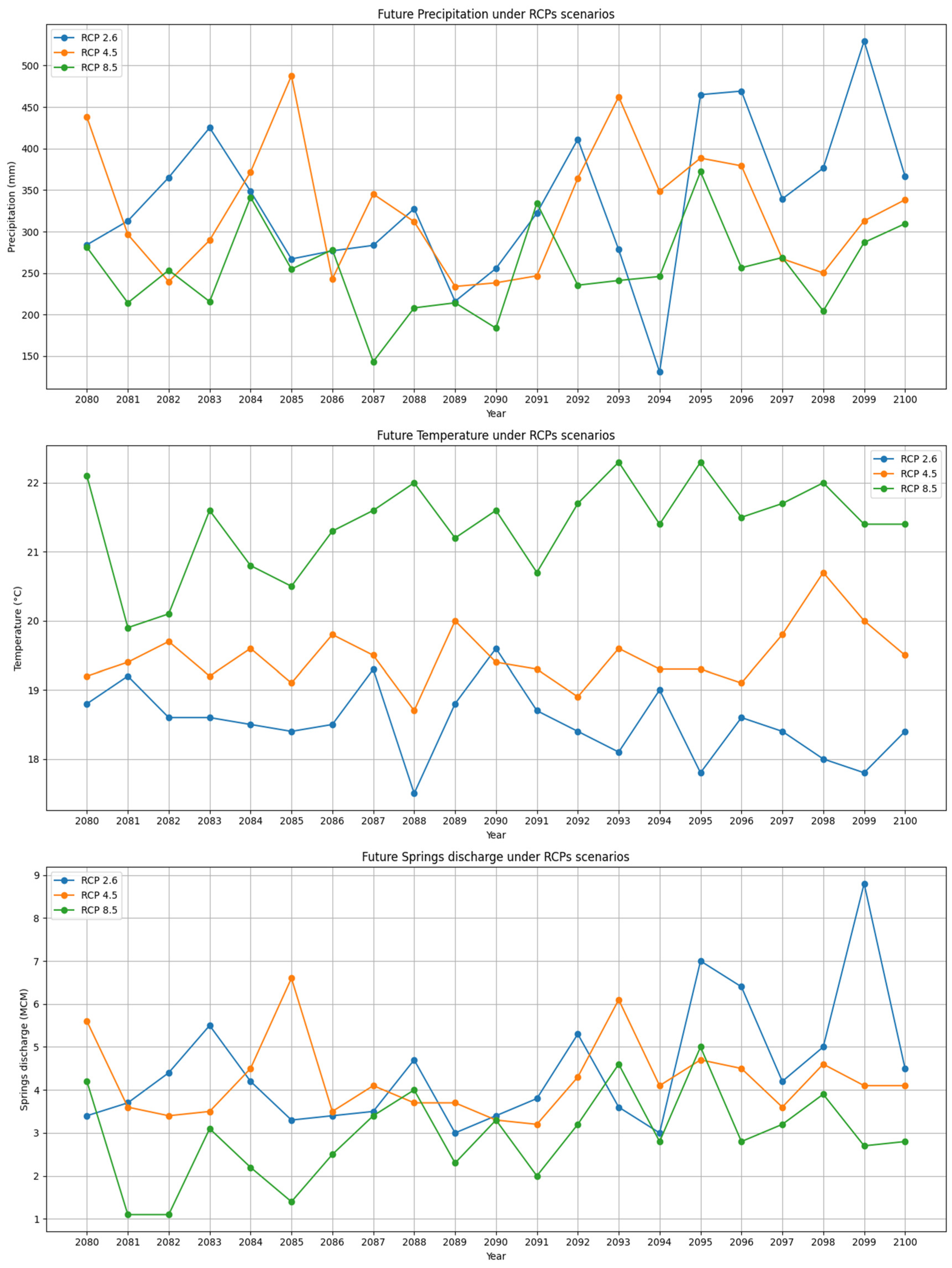
The same analysis has been done for the future period 2080 to 2100 and is shown in Figure 6.
The first subplot represents the projected precipitation under different RCP scenarios. The average precipitation under RCP2.6 is 335.8 mm, which is very close to the historical average of 334.12 mm recorded from 1990 to 2020. This suggests a relatively stable precipitation pattern under the low-emission scenario. Conversely, the average precipitation under RCP4.5 is projected to be 326.4 mm, indicating a slight decrease compared to the historical average. RCP8.5 shows an average precipitation of 254.4 mm, which is significantly lower than the historical data, indicating a substantial reduction in annual precipitation under the high-emission scenario. The temperature is shown in the second subplot of Figure 6. The average temperature under RCP2.6 is 18.5 °C, slightly lower than the historical average of 18.9 °C. This minor decrease is expected due to the mitigative effects of the low-emission scenario. For RCP4.5, the projected average temperature is 19.5 °C, which is higher than the historical average, indicating that moderate emissions will result in a noticeable increase in temperature. Under RCP8.5, the average temperature is projected to rise significantly to 21.4 °C, indicating a substantial increase compared to the historical data. This suggests that high emission scenarios will lead to a significant rise in average temperatures, contributing to the impacts of global warming.
The third subplot in Figure 6 shows the projected spring discharge for the period 2080 to 2100. The average spring discharge under RCP2.6 is 4.5 MCM, closely aligning with the historical average of 4.3 MCM. This increase in spring discharge is aligned with the increment in precipitation and the decrease in temperature, highlighting the benefits of the low-emission scenario in maintaining water resources. For RCP4.5, the projected average spring discharge is 4.2 MCM, indicating a slight decrease from the historical average, which could be attributed to the reduced precipitation and increased temperature. Under RCP8.5, the average spring discharge is projected to be 2.9 MCM, significantly lower than the historical average, suggesting that the high temperatures and reduced precipitation under this scenario will lead to a substantial decrease in water availability. These shows the impact of climate change scenarios on water resource availability in the sub-catchment.

4. Discussion

Previous studies have consistently documented significant changes in climate patterns across Mediterranean and arid regions, indicating a decline in precipitation and an increase in temperature as critical components of climate change. Such trends have profound implications for water resources, particularly in areas like Palestine, where these impacts are increasingly apparent [41,42]. In this context, the trend analysis using the Mann-Kendall test and Sen’s Slope estimator reveals significant climatic changes in the Al-Badan sub-catchment over the past 30 years. An average annual decrease in precipitation of 5.5 mm (totaling 165 mm over the study period) is observed, along with an increase in average annual temperature of 0.061 °C (cumulatively 1.84 °C). These findings align with global climate change trends and further corroborate shifts reported in previous research. The significant reduction in spring discharge, averaging a decrease of 110,920 m3 per year, underscores the direct impact of these climatic changes on water availability. This reduction is consistent with evidence indicating that declining precipitation and rising temperatures lead to substantial decreases in spring and streamflow, thereby affecting water security and local ecosystems [43,44]. Such results highlight the urgent need for management strategies to address these climatic shifts. Multiple linear regression analysis demonstrates that precipitation and temperature significantly influence spring discharge in the Al-Badan sub-catchment, accounting for approximately 60% of the variability in discharge. Specifically, each additional millimeter of precipitation correlates with a 0.03 MCM increase in discharge, while each degree Celsius rise in temperature is associated with a decrease of 14.34 MCM in discharge. These relationships are consistent with findings from other Mediterranean studies [45]. However, it is essential to recognize that other factors, such as land use changes, vegetation cover, soil moisture, groundwater levels, and human activities, also play a role in influencing spring discharge. These factors were not included in this analysis due to data limitations, yet they are critical for a comprehensive understanding of hydrological responses. Literature suggests that incorporating these variables can significantly enhance insights into water resource dynamics [44,45].
Rising temperatures can significantly impact spring discharge by increasing evaporation, which lowers the water table and reduces available water. Warmer conditions may also alter precipitation patterns, leading to decreased groundwater recharge and further diminishing spring flow [1]. A decrease in precipitation exacerbates this issue by reducing the amount of water entering aquifers, causing lower flow rates in springs. Over time, prolonged periods of diminished precipitation can result in springs drying up or flowing at reduced capacities, impacting ecosystems that rely on this water source and reducing water availability for human use [19]. Additionally, temperature changes can affect groundwater density and flow, disrupting the quantity and timing of discharge, which further affects ecosystems and overall water availability.
Climate change scenarios for 2040–2060 and 2080–2100 shows significant impacts on spring discharge in the Al-Badan sub-catchment due to changes in precipitation and temperature. For the near term (2040–2060), the RCP2.6 scenario predicts a slight increase in spring discharge to 4.6 MCM, attributed to stable precipitation (334.5 mm) and slightly lower temperatures (18.5 °C). In contrast, the RCP4.5 and RCP8.5 scenarios forecast reductions in discharge to 3.9 MCM and 4.0 MCM, respectively, due to decreased precipitation and increased temperatures. These results are consistent with previous studies highlighting the effects of climate change on water resources in the Mediterranean region (García-Ruiz et al., 2007). In the long term (2080–2100), projections show more significant changes. Under RCP2.6, discharge is expected to be 4.5 MCM, close to the historical average, due to minimal changes in precipitation and a slight decrease in temperature. In contrast, RCP4.5 and RCP8.5 scenarios predict significant declines to 4.2 MCM and 2.9 MCM, respectively, driven by reductions in precipitation and increases in temperature. These projections emphasize the urgent need for sustainable water management, aligning with the IPCC findings on the severe impacts of high-emission scenarios on water resources. To address these challenges, focus on water conservation, improve storage infrastructure, and integrate climate projections into management strategies. Expanding research to include factors like land use and soil moisture will enhance prediction accuracy.

5. Conclusions

This study provides a comprehensive analysis of the hydroclimatic trends and climate change impacts on groundwater resources in the Al-Badan sub-catchment, an important sub-catchment within the Faria catchment in northern Palestine. The analysis shows a significant decline in annual precipitation and an increase in temperature over the past 30 years, resulting in a marked reduction in spring discharge. Precipitation has dropped by about 165 mm, and temperatures have risen by 1.84 °C. Consequently, spring discharge has decreased by roughly 110,920 m3/year, impacting agricultural and potable water needs. The multiple linear regression model developed in this study, which explains 60% of the variability in spring discharge, highlights the complex interactions between precipitation, temperature, and discharge. While precipitation positively affects discharge, rising temperatures significantly reduce it. This model is also used for future predictions of spring discharge. Future projections indicate that climate change will impact water availability in the Al-Badan sub-catchment under different RCP scenarios. For the period 2040–2060, RCP8.5 predicts a 150 mm decrease in precipitation and a 3.4 °C rise in temperature, potentially reducing spring discharge by 140,000 m3/year. RCP2.6 projects a 90 mm decrease in precipitation and a 2.0 °C rise in temperature, leading to a reduction in spring discharge of about 80,000 m3/year. For the period 2080–2100, RCP8.5 forecasts a 200 mm decrease in precipitation and a 4.5 °C rise in temperature, resulting in a potential reduction of 200,000 m3/year in spring discharge. In contrast, RCP2.6 predicts a 120 mm decrease in precipitation and a 2.8 °C rise in temperature, with a spring discharge reduction of approximately 100,000 m3/year. The study highlights the need for adaptive water management to address climate change impacts. Improving conservation, infrastructure, and climate resilience is crucial for sustaining groundwater in the Al-Badan sub-catchment. This research offers valuable insights for future water management and policymaking.

Author Contributions

Conceptualization, H.F., S.S. and G.G.; methodology, H.F.; software, H.F.; validation, H.F., S.S. and G.G.; formal analysis, H.F.; investigation, H.F.; resources, H.F.; data curation, H.F.; writing—original draft preparation, H.F.; writing—review and editing, H.F.; visualization, H.F.; supervision, G.G.; project administration, G.G.; funding acquisition, G.G. All authors have read and agreed to the published version of the manuscript.

Funding

This research received no external funding.

Data Availability Statement

The data used and examined in the present research can be accessed through the Palestinian Water Authority and the Palestinian Meteorology Department. Additionally, certain datasets are also accessible within the [CORDEX] repository.

Acknowledgments

The authors would like to acknowledge IUSS Pavia and the University of Brescia for granting them the opportunity to carry their doctoral studies. They also wish to express their appreciation to Al Najah University for their collaborative efforts.

Conflicts of Interest

The authors declare no conflicts of interest.

References

  1. Faquseh, H.; Grossi, G. The effect of climate change on groundwater resources availability: A case study in the city of Brescia, Northern Italy. Sustain. Water Resour. Manag. 2023, 9, 113. [Google Scholar] [CrossRef]
  2. El-Fadel, M.; Zeinati, M.; Jamali, D. Water Resources in Lebanon: Characterization, Water Balance and Constraints. Int. J. Water Resour. Dev. 2000, 16, 615–638. [Google Scholar] [CrossRef]
  3. Brekke, L.D.; Kiang, J.E.; Olsen, J.R.; Pulwarty, R.S.; Raff, D.A.; Turnipseed, D.P.; Webb, R.S.; White, K.D. Climate Change and Water Resources Management: A Federal Perspective; Circular; U.S. Geological Survey: Reston, VA, USA, 2009. [CrossRef]
  4. Giorgi, F.; Lionello, P. Climate Change Projections for the Mediterranean Region. Glob. Planet. Chang. 2008, 63, 90–104. [Google Scholar] [CrossRef]
  5. El-Fadel, M.; Bou-Zeid, E. Climate Change and Water Resources in the Middle East: Vulnerability, Socio-Economic Impacts and Adaptation. In Climate Change in the Mediterranean; Edward Elgar Publishing: Cheltenham, UK, 2003. [Google Scholar] [CrossRef]
  6. Shadeed, S.M.; Judeh, T.G.; Almasri, M.N. Developing GIS-Based Water Poverty and Rainwater Harvesting Suitability Maps for Domestic Use in the Dead Sea Region (West Bank, Palestine). Hydrol. Earth Syst. Sci. 2019, 23, 1581–1592. [Google Scholar] [CrossRef]
  7. UNEP. Division for Communications and Strategic Partnerships. Report of the State of World Population. 2021. Available online: https://wedocs.unep.org/handle/20.500.11822/32692 (accessed on 1 October 2024).
  8. UNEP. State of Environment and Outlook Report for the Occupied Palestinian Territory. 2020. Available online: https://wedocs.unep.org/20.500.11822/32268 (accessed on 1 October 2024).
  9. ENEP. Division for Environmental and Natural Resources. Water Availability and Groundwater Depletion in the West Bank. 2020. Available online: https://www.unep.org/publications-data (accessed on 1 October 2024).
  10. Abboushi, A.M.; Almasri, M.N.; Shadeed, S.M. A Preliminary Investigation of Wadi–Aquifer Interaction in the Semi-Arid Watershed of Faria, Palestine Using Tracer-Based Methodology. Environ. Earth Sci. 2014, 73, 7861–7872. [Google Scholar] [CrossRef]
  11. Wasimi, S.A. Climate Change in the Middle East and North Africa (MENA) Region and Implications for Water Resources Project Planning and Management. Int. J. Clim. Chang. Strateg. Manag. 2010, 2, 297–320. [Google Scholar] [CrossRef]
  12. Mizyed, N. Climate Change Challenges to Groundwater Resources: Palestine as a Case Study. J. Water Resour. Prot. 2018, 10, 215–229. [Google Scholar] [CrossRef]
  13. Kosasih, E.A.; Zikri, A.; Dzaky, M.I. Water Vapor Desorption from Silica Gel in a Combined Drying and Double-Condenser Compression Refrigeration System. Heliyon 2022, 8, e09757. [Google Scholar] [CrossRef]
  14. Shadeed, S. Up to Date Hydrological Modeling in Arid and Semiarid Catchment: The Case of Faria Catchment, West Bank, Palestine. Ph.D. Thesis, Freiberg University, Freiberg, Germany, 2008. [Google Scholar]
  15. Saleh, Y. Artificial Groundwater Recharge in Faria Catchment: A Hydrogeological Study. Master’s Thesis, An-Najah National University, Nablus, Palestine, 2009. [Google Scholar]
  16. Shadeed, S. Spatio-Temporal Drought Analysis in Arid and Semi-Arid Regions: A Case Study from Palestine. Arab. J. Sci. Eng. 2012, 38, 2303–2313. [Google Scholar] [CrossRef]
  17. Shadeed, S.; Lange, J. Rainwater Harvesting to Alleviate Water Scarcity in Dry Conditions: A Case Study in Faria Catchment, Palestine. Water Sci. Eng. 2010, 3, 132–143. [Google Scholar]
  18. Shaheen, H.; Jayyousi, A.; Shadeed, S.; Jarrar, A. Hydrograph Estimation in Semiarid Regions Using GIS Supported GIUH Model. In Proceedings of the Ninth International Water Technology Conference (IWTC9), Sharm El-Sheikh, Egypt, 17–20 March 2005; p. 371. [Google Scholar]
  19. Faquseh, H.; Grossi, G. Trend Analysis of Precipitation, Temperature and Snow Water Equivalent in Lombardy Region, Northern Italy. Sustain. Water Resour. Manag. 2024, 10, 18. [Google Scholar] [CrossRef]
  20. Ciampittiello, M.; Marchetto, A.; Boggero, A. Water Resources Management Under Climate Change: A Review. Preprints 2023, 16, 3590. [Google Scholar] [CrossRef]
  21. Adji, T.N.; Bahtiar, I.Y. Rainfall–Discharge Relationship and Karst Flow Components Analysis for Karst Aquifer Characterization in Petoyan Spring, Java, Indonesia. Environ. Earth Sci. 2016, 75, 9. [Google Scholar] [CrossRef]
  22. Kumar, C.P.; Singh, S. Climate Change Effects on Groundwater Resources. Octa J. Environ. Res. 2015, 3, 264–271. [Google Scholar]
  23. Meinshausen, M.; Smith, S.J.; Calvin, K.; Daniel, J.S.; Kainuma, M.L.; Lamarque, J.F.; Matsumoto, K.; Montzka, S.A.; Raper, S.C.; Riahi, K.; et al. The RCP Greenhouse Gas Concentrations and Their Extensions from 1765 to 2300. Clim. Chang. 2011, 109, 213–241. [Google Scholar] [CrossRef]
  24. Li, H.; Sheffield, J.; Wood, E.F. Bias Correction of Monthly Precipitation and Temperature Fields from Intergovernmental Panel on Climate Change AR4 Models Using Equidistant Quantile Matching. J. Geophys. Res. 2010, 115, D10101. [Google Scholar] [CrossRef]
  25. PCBS. Population, Housing and Establishments Census 2017: Census Final Results—Detailed Report—Palestine. Ramallah—Palestine. 2018. Available online: https://www.pcbs.gov.ps/pcbs_2012/Publications.aspx (accessed on 9 September 2023).
  26. Shadeed, S.; Shaheen, H.; Jayyousi, A. GIS-Based KW-GIUH Hydrological Model of Semiarid Catchments: The Case of Faria Catchment, Palestine. Arab. J. Sci. Eng. 2006, 32, 3–16. [Google Scholar]
  27. PMD. Available online: https://www.pmd.ps/en (accessed on 9 September 2023).
  28. PWA. Palestinian Water Authority. Available online: https://www.pwa.ps/english.aspx (accessed on 9 September 2023).
  29. ESGF. Cordex. Available online: https://esg-dn1.nsc.liu.se/search/cordex/ (accessed on 9 September 2023).
  30. Aditya, F.; Gusmayanti, E.; Sudrajat, J. Rainfall Trend Analysis Using Mann-Kendall and Sen’s Slope Estimator Test in West Kalimantan. IOP Conf. Ser. Earth Environ. Sci. 2021, 893, 012006. [Google Scholar] [CrossRef]
  31. Xing, L.; Huang, L.; Chi, G.; Yang, L.; Li, C.; Hou, X. A Dynamic Study of a Karst Spring Based on Wavelet Analysis and the Mann-Kendall Trend Test. Water 2018, 10, 698. [Google Scholar] [CrossRef]
  32. Kendall, M.G. Rank Correlation Methods; Griffin: London, UK, 1975. [Google Scholar]
  33. Mann, H.B. Nonparametric Test against the Trend. Econometrica 1945, 13, 245–259. [Google Scholar] [CrossRef]
  34. García-Ruiz, J.M.; Lopez-Moreno, J.I.; Vicente-Serrano, S.M.; Lasanta-Martinez, T.; Begueria, S. Mediterranean Water Resources in a Global Change Scenario. Earth Sci. Rev. 2011, 105, 121–139. [Google Scholar] [CrossRef]
  35. Fiorillo, F.; Doglioni, A. The Relation Between Karst Spring Discharge and Rainfall by Cross-Correlation Analysis (Campania, Southern Italy). Hydrogeol. J. 2010, 18, 1881–1895. [Google Scholar] [CrossRef]
  36. Harbaugh, A.W.; McDonald, M.G. User’s Documentation for MODFLOW-96, an Update to the U.S. Geological Survey Modular Finite Difference Ground Water Flow Model; U.S. Geological Survey: Reston, VA, USA, 1996. [CrossRef]
  37. Karl, T.R.; Knight, R.W. Secular Trends of Precipitation Amount, Frequency, and Intensity in the United States. Bull. Am. Meteorol. Soc. 1998, 79, 231–241. [Google Scholar] [CrossRef]
  38. IPCC. Climate Change 2013: The Physical Science Basis. Contribution of Working Group I to the Fifth Assessment Report of the Intergovernmental Panel on Climate Change; Stocker, T.F., Qin, D., Plattner, G.K., Tignor, M., Allen, S.K., Boschung, J., Nauels, A., Xia, Y., Bex, V., Midgley, P.M., Eds.; Cambridge University Press: Cambridge, UK; New York, NY, USA, 2013; 1535p. [Google Scholar] [CrossRef]
  39. Annisa, H.N.; Nugroho, B.D. Analysis and Projections of Rainfall Using Representative Concentration Pathways (RCPs) Scenarios in Sleman Yogyakarta. IOP Conf. Ser. Earth Environ. Sci. 2021, 653, 012099. [Google Scholar] [CrossRef]
  40. Andrade, C.W.L.; Montenegro, S.M.G.L.; Montenegro, A.A.A.; Lima, J.R.d.S.; Srinivasan, R.; Jones, C.A. Climate Change Impact Assessment on Water Resources Under RCP Scenarios: A Case Study in Mundaú River Basin, Northeastern Brazil. Int. J. Climatol. 2020, 41, E1045–E1061. [Google Scholar] [CrossRef]
  41. Lelieveld, J.; Hadjinicolaou, P.; Kostopoulou, E.; Chenoweth, J.; El Maayar, M.; Giannakopoulos, C.; Hannides, C.; Lange, M.A.; Tanarhte, M.; Tyrlis, E.; et al. Climate Change and Impacts in the Eastern Mediterranean and the Middle East. Clim. Chang. 2012, 114, 667–687. [Google Scholar] [CrossRef]
  42. Haddad, M. Irrigation Adaptation to Changing Water Supply: Palestine as a Case Study. Impacts Glob. Clim. Chang. 2005, 23, 1–12. [Google Scholar] [CrossRef]
  43. Alpert, P.; Ben-Gai, T.; Baharad, A.; Benjamini, Y.; Yekutieli, D.; Colacino, M.; Diodato, L.; Ramis, C.; Homar, V.; Romero, R.; et al. The Paradoxical Increase of Mediterranean Extreme Daily Rainfall in Spite of Decrease in Total Values. Geophys. Res. Lett. 2002, 29, 31-1–31-4. [Google Scholar] [CrossRef]
  44. Toonen, W.H.J.; Middelkoop, H.; Konijnendijk, T.Y.M.; Macklin, M.G.; Cohen, K.M. The Influence of Hydroclimatic Variability on Flood Frequency in the Lower Rhine. Earth Surf. Process. Landf. 2016, 41, 1266–1275. [Google Scholar] [CrossRef]
  45. Jones, R.N.; Chiew, F.H.S.; Boughton, W.C.; Zhang, L. Estimating the Sensitivity of Mean Annual Runoff to Climate Change Using Selected Hydrological Models. Adv. Water Resour. 2006, 29, 1419–1429. [Google Scholar] [CrossRef]
Figure 1. The map of Al-Badan sub-catchment includes the main springs.
Hydrology 11 00169 g001
Figure 2. Yearly trends in precipitation, temperature, and springs discharge for Al-Badan sub-catchment from 1990 to 2020.
Hydrology 11 00169 g002
Figure 3. Relation between yearly precipitation and temperature with the total springs discharge in Al-Badan sub-catchment.
Hydrology 11 00169 g003
Figure 4. Residuals Analysis and Prediction Interval Assessment.
Hydrology 11 00169 g004
Figure 5. Future Projections of Precipitation, Temperature, and Springs Discharge Under Different RCP Scenarios (2040–2060).
Hydrology 11 00169 g005
Figure 6. Future Projections of Precipitation, Temperature, and Spring Discharge Under Different RCP Scenarios (2080–2100).
Hydrology 11 00169 g006
Table 1. Summary of trend analysis for precipitation, temperature, and springs discharge in Al Badan sub-catchment.
ParameterAverage Yearly ValueMann-Kendall Test Z-Statisticp-ValueSen’s Slope EstimateSignificance
Precipitation334.12 mm−2.010.045−5.5 mm/yearSignificant decrease
Temperature18.9 °C3.8580.00010.061325 °C/yearSignificant increase
Springs Discharge4.3 MCM−2.210.027−110,920 m3/yearSignificant decrease
Disclaimer/Publisher’s Note: The statements, opinions and data contained in all publications are solely those of the individual author(s) and contributor(s) and not of MDPI and/or the editor(s). MDPI and/or the editor(s) disclaim responsibility for any injury to people or property resulting from any ideas, methods, instructions or products referred to in the content.