Hydrologic Trends in the Upper Nueces River Basin of Texas—Implications for Water Resource Management and Ecological Health


Abstract
1. Introduction
2. Methodology
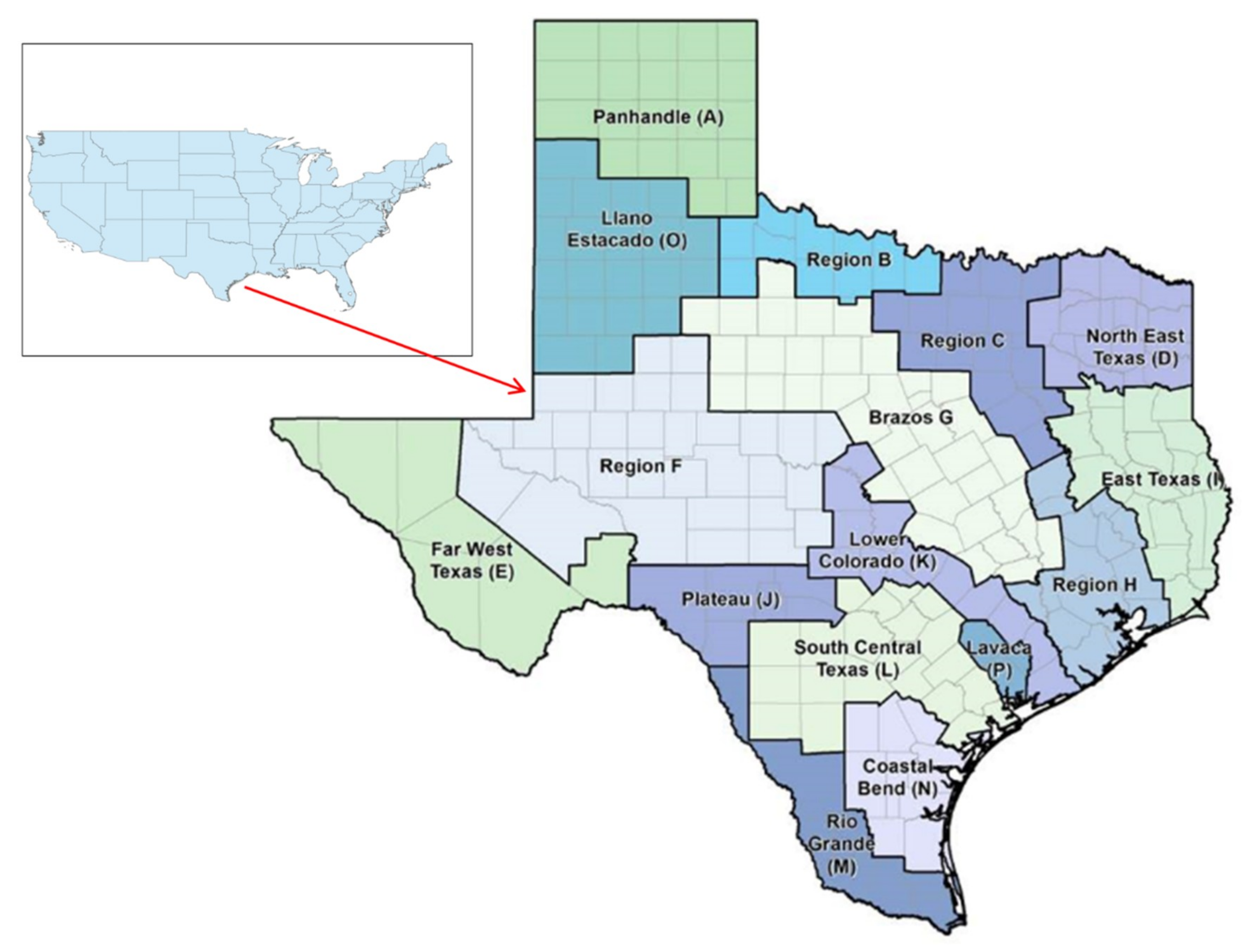
2.1. Background Information
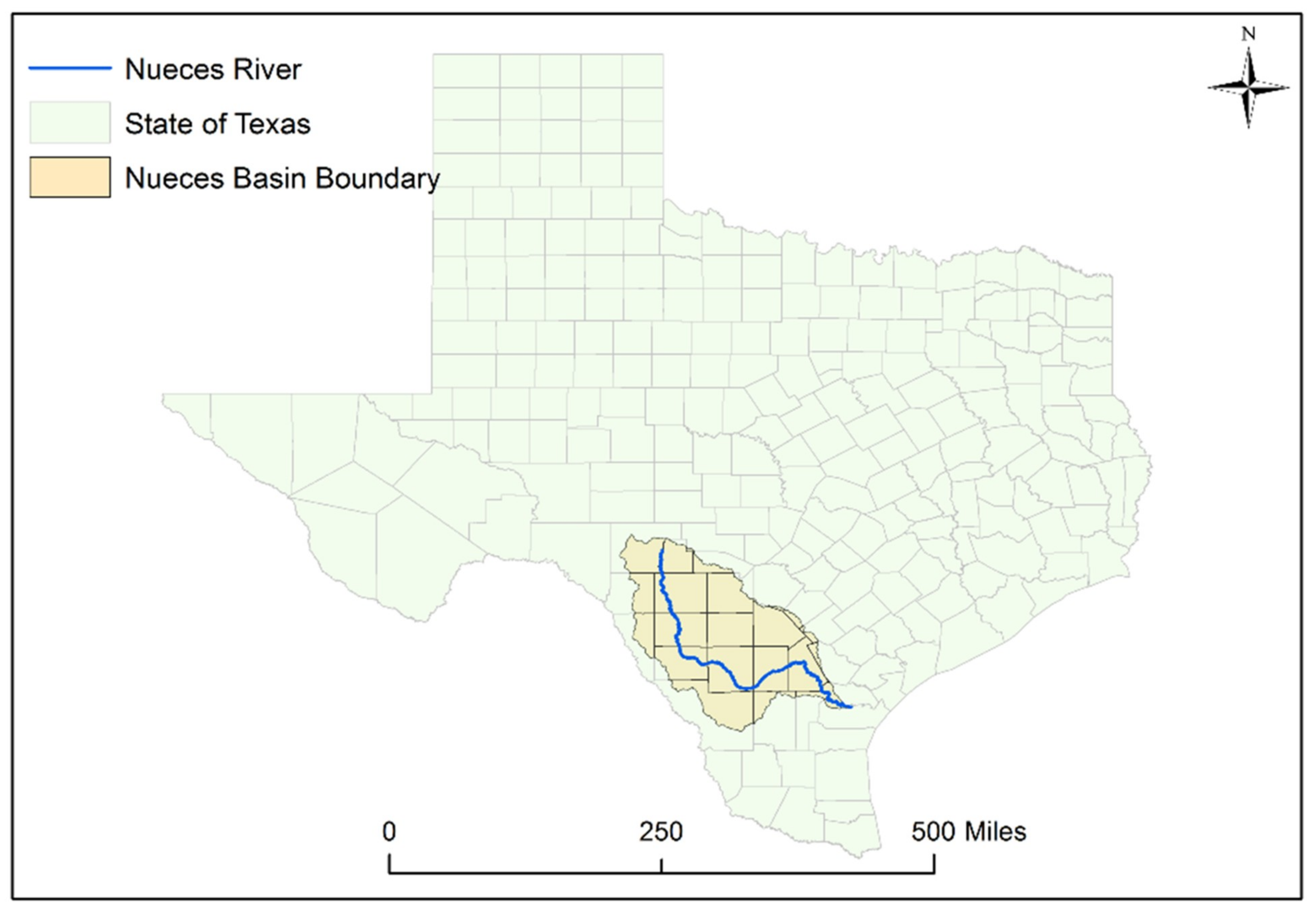
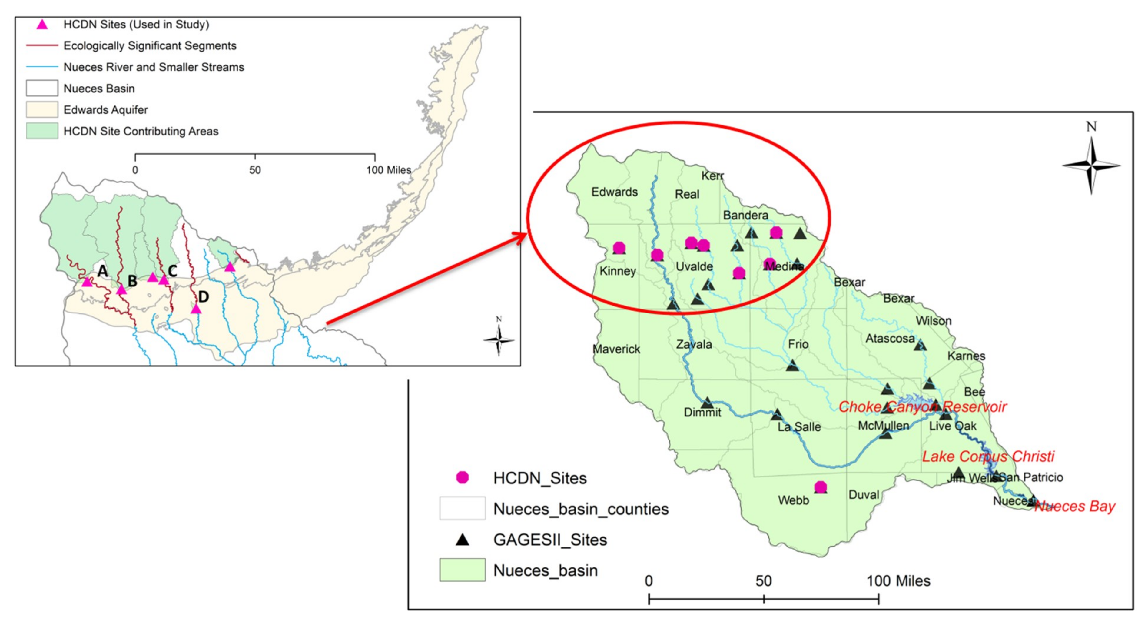
2.2. Site Description
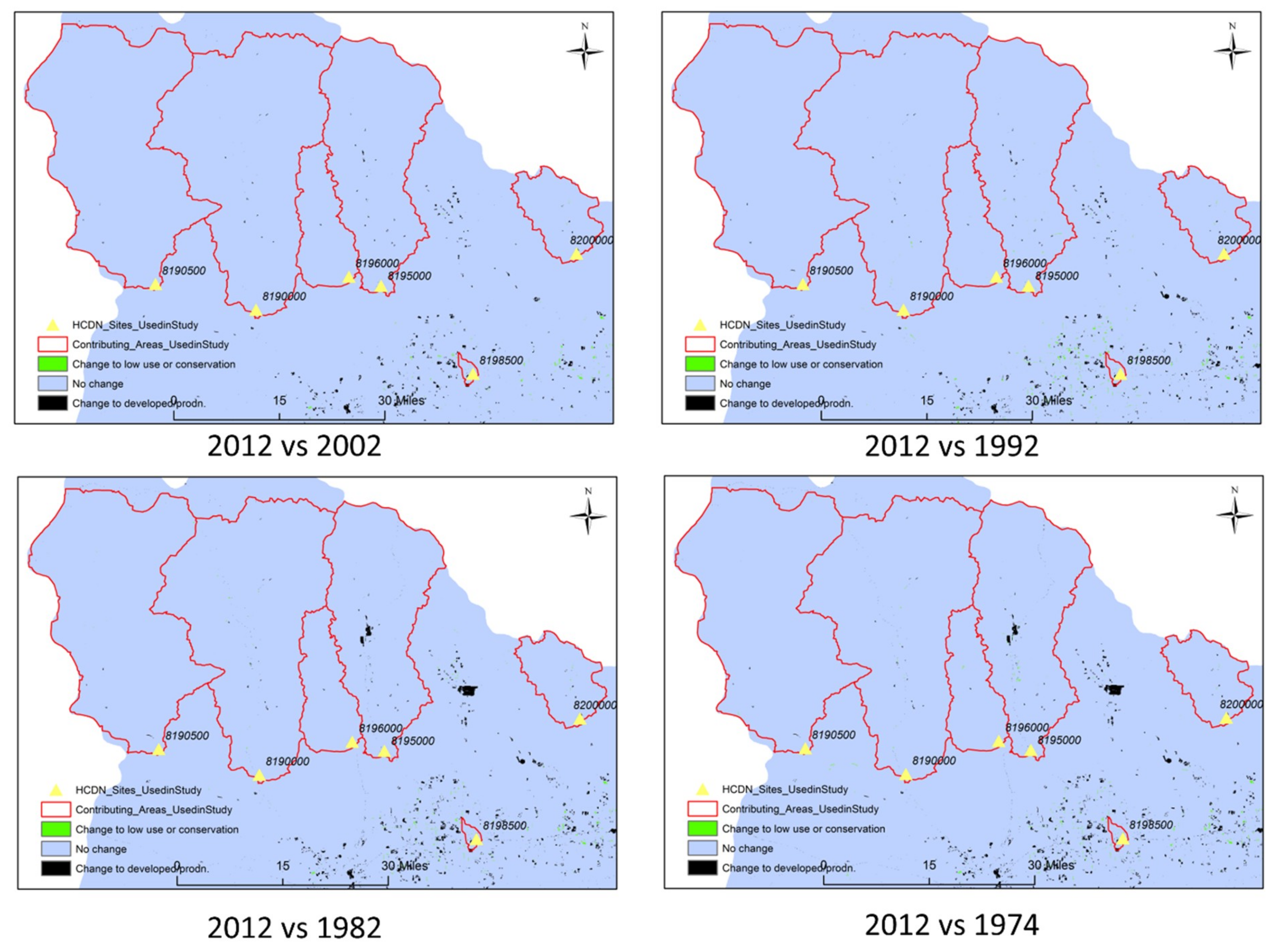
2.3. Data Sources
2.4. Hydroclimatic Data Analysis
2.4.1. Trend Analysis (MMK)
2.4.2. Low Flow Metrics (Annual Minimum and 7-day Low Flows)
2.4.3. Streamflow-Precipitation Elasticity
2.4.4. Drought Indices (SDI and SPI)
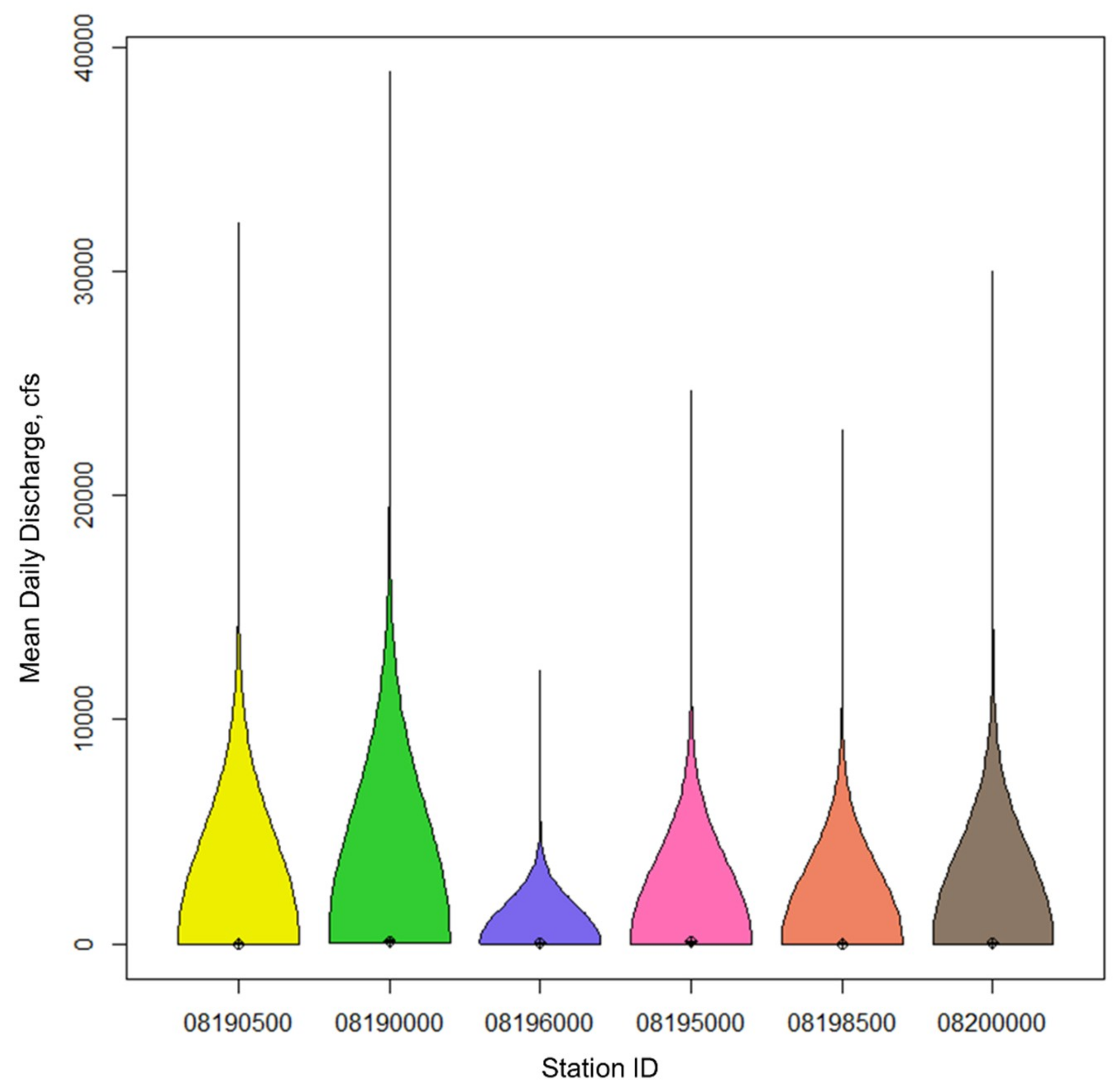
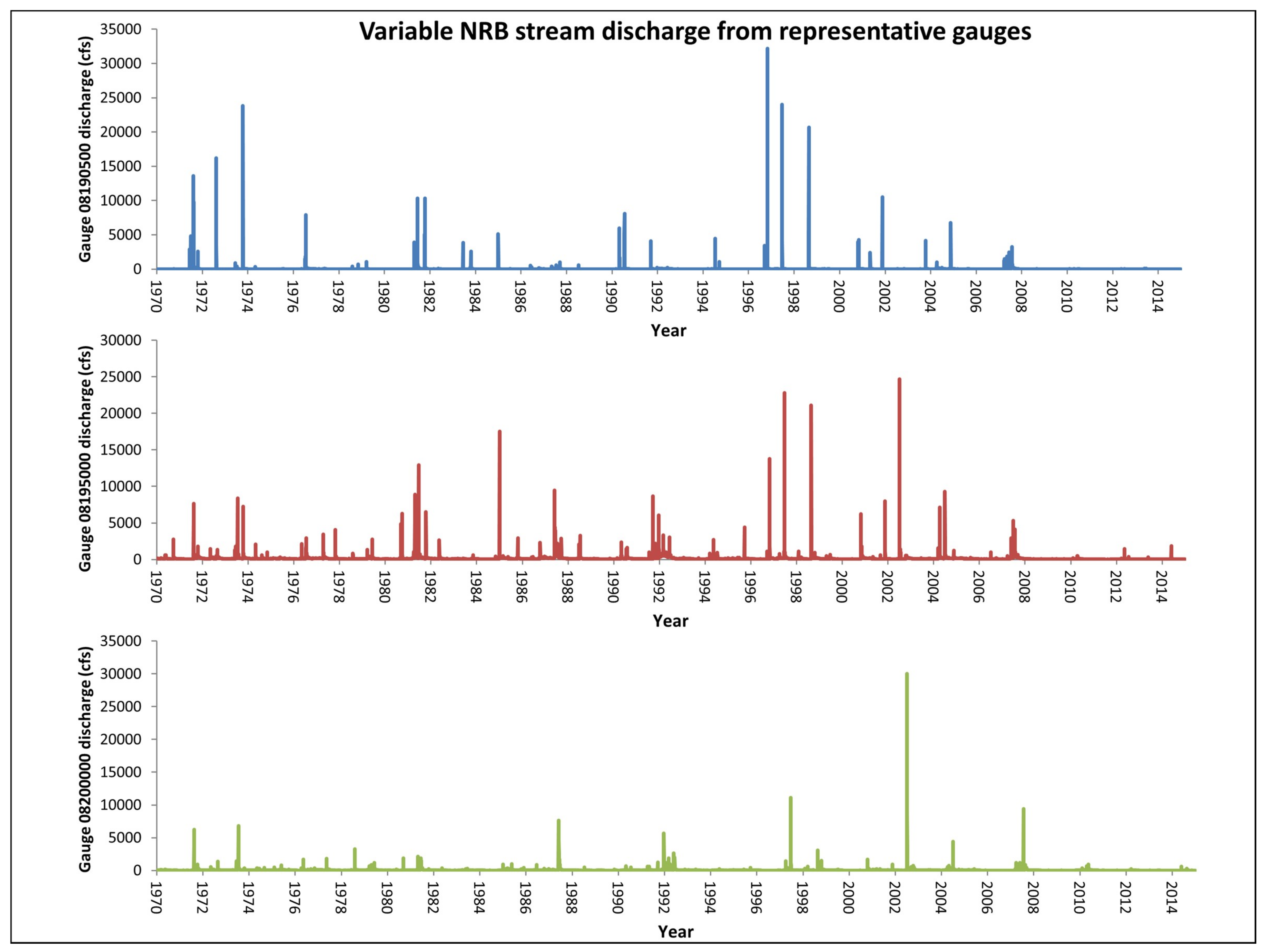
3. Results
3.1. MMK Trend Analyses – 1970 to 2014
3.2. MMK Trend Analyses – 1994 to 2014
3.3. Low Flow Indicators
3.4. Streamflow-Precipitation Elasticity
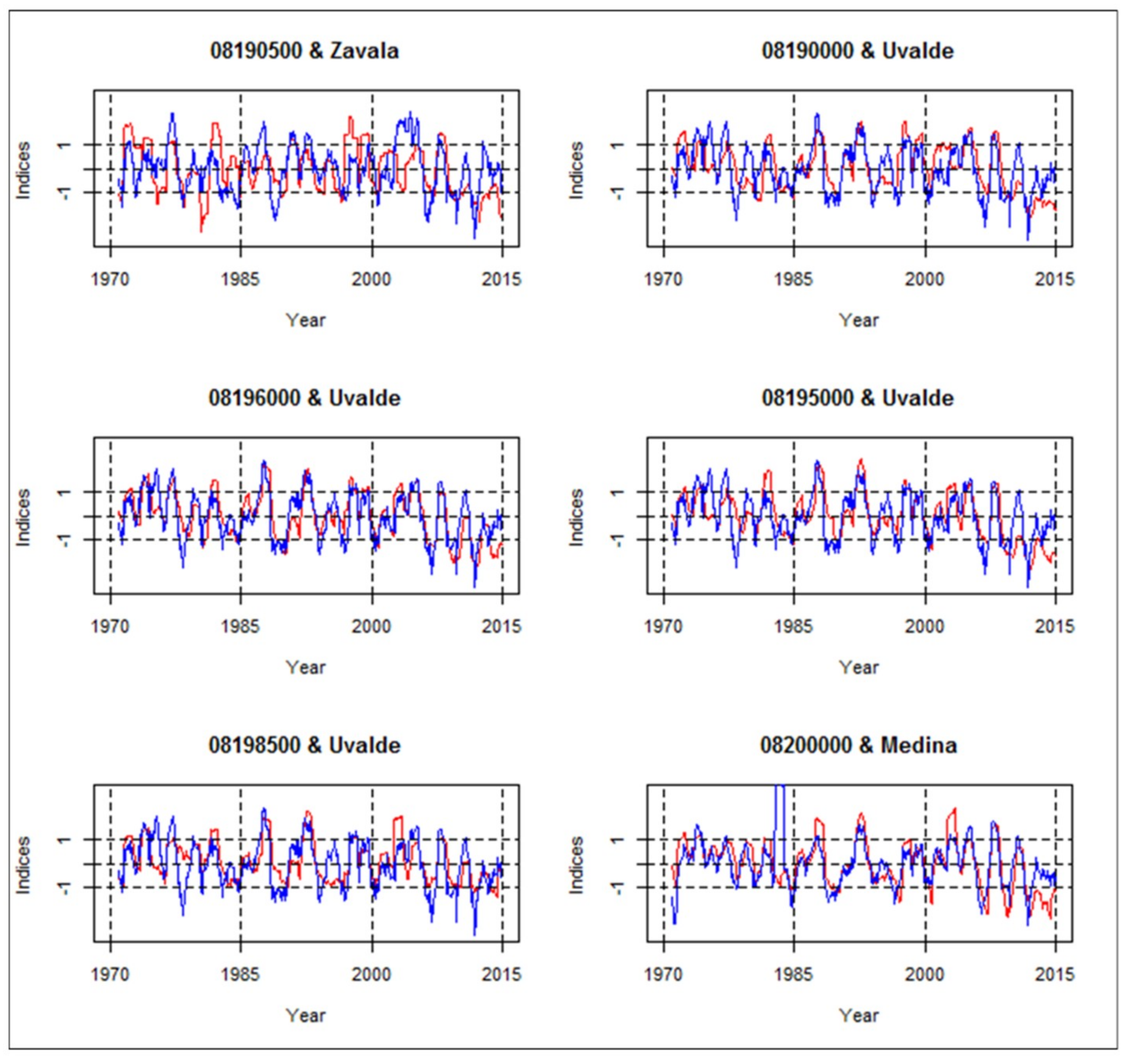
3.5. Drought Indices (SDI and SPI)
3.6. ET Trends
4. Discussion
5. Conclusions
Author Contributions
Funding
Acknowledgments
Conflicts of Interest
References
- Norwine, J.; John, K. The Changing Climate of South Texas, 1900-2100: Problems and Prospects, Impacts and Implications; CREST-RESSACA Texas A & M University-Kingsville: Kingsville, TX, USA, 2007. [Google Scholar]
- Sturdivant, A.W.; Rogers, C.S.; Rister, M.E.; Lacewell, R.D.; Norris, J.W.; Leal, J.; Garza, J.A.; Adams, J. Economic costs of desalination in south Texas: A case study. J. Contemp. Water Res. Educ. 2007, 137, 21–39. [Google Scholar] [CrossRef]
- Uddameri, V.; Honnungar, V.; Hernandez, E.A. Assessment of groundwater water quality in central and southern Gulf Coast Aquifer, TX using principal component analysis. Environ. Earth Sci. 2014, 71, 2653–2671. [Google Scholar] [CrossRef]
- Clark, J.S.; Melillo, J.; Mohan, J.; Salk, C. The seasonal timing of warming that controls the onset of the growing season. Glob. Change Biol. 2014, 20, 1136–1145. [Google Scholar] [CrossRef] [PubMed]
- Tebaldi, C.; Hayhoe, K.; Arblaster, J.M.; Meehl, G.A. Going to the extremes. Clim. Chan. 2006, 79, 185–211. [Google Scholar] [CrossRef]
- Venkataraman, K.; Tummuri, S.; Medina, A.; Perry, J. 21st century drought outlook for major climate divisions of Texas based on CMIP5 multimodel ensemble: Implications for water resource management. J. Hydrol. 2016, 534, 300–316. [Google Scholar] [CrossRef]
- Poshtiri, M.P.; Pal, I. Patterns of hydrological drought indicators in major U.S. river basins. Clim. Chan. 2015, 134, 549–563. [Google Scholar] [CrossRef]
- Hernandez, E.A.; Uddameri, V. Standardized precipitation evaporation index (SPEI)-based drought assessment in semi-arid south Texas. Environ. Earth Sci. 2014, 71, 2491–2501. [Google Scholar] [CrossRef]
- Petrone, K.C.; Hughes, J.D.; Van Niel, T.G.; Silberstein, R.P. Streamflow decline in southwestern Australia, 1950–2008. Geophys. Res. Lett. 2010, 37, 11. [Google Scholar] [CrossRef]
- Kibria, K.N.; Ahiablame, L.; Hay, C.; Djira, G. Streamflow trends and responses to climate variability and land cover change in South Dakota. Hydrology 2016, 3, 2. [Google Scholar] [CrossRef]
- Kim, B.S.; Hong, S.J.; Lee, H.D. The potential effects of climate change on streamflow in Rivers Basin of Korea using precipitation elasticity. Environ. Eng. Res. 2013, 18, 9–20. [Google Scholar] [CrossRef]
- Schaake, J.C. From climate to flow. In Climate Change and U.S. Water Resources; Waggoner, P.E., Ed.; John Wiley and Sons Inc.: New York, NY, USA, 1990; pp. 177–206. [Google Scholar]
- Banta, J.R.; Lambert, R.B.; Slattery, R.N.; Ockerman, D.J. Streamflow Gain and Loss and Water Quality in the Upper Nueces River Basin, South-Central Texas, 2008–10; U.S. Geological Survey Scientific Investigations Report 2012–5181; U.S. Geological Survey: Reston, VA, USA, 2012; 40p. Available online: http://pubs.usgs.gov/sir/2012/5181 (accessed on 15 April 2017).
- Skoulikaris, C.; Zafirakou, A. River Basin Management Plans as a tool for sustainable transboundary river basins’ management. Environ. Sci. Pollut. Res. 2019. [Google Scholar] [CrossRef] [PubMed]
- Coastal Bend Regional Water Planning Group; Henningson, Durham and Richardson Engineering, Inc. Coastal Bend Regional Water Planning Area Region N Regional Water Plan Volume II Water Management Strategies; Texas Water Development Board: Austin, TX, USA, 2010. Available online: http://www.twdb.texas.gov/waterplanning/rwp/plans/2011/N/Region_N_2011_RWPV2.pdf (accessed on 20 June 2017).
- Coastal Bend Regional Water Planning Group; Henningson, Durham and Richardson Engineering, Inc. Coastal Bend Regional Water Planning Area Region N; Texas Water Development Board: Austin, TX, USA, 2015. Available online: https://www.twdb.texas.gov/waterplanning/rwp/plans/2016/N/Region_N_2016_RWP.pdf (accessed on 20 June 2017).
- Texas A&M AgriLife. Water in Texas. 2018. Available online: https://agrilife.org/siwi/water_in_texas/ (accessed on 7 November 2018).
- Kromann, J. Surface Water Recharge in Karst: Edwards-Trinity Aquifers-Nueces River System; Texas Scholar Works; University of Texas Libraries: Austin, TX, USA, 2015; Available online: https://repositories.lib.utexas.edu/handle/2152/44401 (accessed on 18 June 2017).
- Mace, R.E.; Anaya, R. Estimate of Recharge to the Edwards (Balcones Fault Zone) and Edwards–Trinity (Plateau) Aquifers in Kinney County, Texas; Aquifers of the Edwards Plateau, Texas Water Development Board Report 360; Texas Water Development Board: Austin, TX, USA, 2004; pp. 345–366. Available online: https://www.twdb.texas.gov/publications/reports/numbered_reports/doc/R360/Ch18.pdf (accessed on 21 March 2017).
- Perkins, R.B.; Vaugh, S.K.; Rodriguez, A.D. Pilot recharge models of the Edwards Aquifer, Texas, 2002. Available online: http://infohouse.p2ric.org/ref/33/32661.pdf (accessed on 21 March 2017).
- Joseph, J.F.; Falcon, H.E.; Sharif, H.O. Hydrologic trends and correlations in south Texas River basins: 1950–2009. J. Hydrol. Eng. 2013, 18, 1653–1662. [Google Scholar] [CrossRef]
- Hamilton, J.M.; Johnson, S.; Esquilin, R.; Thompson, E.L.; Wiatrek, A.; Luevano, G.; Gregory, D.; Burgoon, C.; Mireles, J.; Gloyd, R.; et al. Edwards Aquifer Authority Hydrologic Data Report for 2003; Edwards Aquifer Authority: San Antonio, TX, USA, 2004; Available online: https://www.edwardsaquifer.org/science-and-maps/research-and-scientific-reports/hydrologic-data-reports (accessed on 29 April 2017).
- Norris, C.W.; Moulton, D.W.; El-Hage, A.; Bradsby, D. Ecologically Significant River and Stream Segments of Region L (South Central) Regional Water Planning Area; Water Resources Technical Series—WRTS-2005-01; Texas Parks and Wildlife: Austin, TX, USA, 2005. Available online: https://tpwd.texas.gov/publications/pwdpubs/media/pwd_rp_v3400_1163.pdf (accessed on 21 March 2017).
- Ockerman, D.J.; Fernandez, C.J. Hydrologic Conditions and Water Quality of Precipitation and Storm Runoff for Two Agricultural Areas of the Oso Creek Watershed, Nueces County, Texas, 2005–08; United States Geological Survey Scientific Investigations Report 2010–5136; United States Geological Survey: Reston, VA, USA, 2010. Available online: http://pubs.usgs.gov/sir/2010/5136/ (accessed on 21 March 2017).
- Ockerman, D.J.; Heitmuller, F.T. Simulation of Streamflow and Suspended Sediment Concentrations and Loads in the Lower Nueces River Watershed, Downstream from Lake Corpus Christi to the Nueces Estuary, South Texas, 1958–2008; United States Geological Survey Scientific Investigations Report 2010–5194; United States Geological Survey: Reston, VA, USA, 2010. Available online: https://pubs.usgs.gov/sir/2010/5194/pdf/sir2010-5194.pdf (accessed on 21 March 2017).
- Adams, J.B. A review of methods and frameworks used to determine the environmental water requirements of estuaries. Hydrol. Sci. J. 2014, 59, 451–465. [Google Scholar] [CrossRef][Green Version]
- Adams, J.S.; Tunnell, J.W. Rincon Bayou salinity monitoring project. Coastal Bend Bays & Estuaries Program Final Report - Publication No. CBBEP-66. 2010. Available online: http://cbbep.org/publications/virtuallibrary/0921report.pdf (accessed on 20 June 2017).
- Montagna, P.A.; Hutchinson, L.M.; Scholz, D.; Palmer, T.; Arismendez, S.; Yoskowitz, D.; Nueces Estuary Ecosystem Management Initiative. Coastal Bend Bays & Estuaries Program - Publication No. CBBEP-72. 2011. Available online: http://www.cbbep.org/publications/virtuallibrary/1018.pdf (accessed on 21 March 2017).
- Murgulet, D.; Murgulet, N.; Spalt, N.; Douglas, A.; Hay, R.G. Impact of hydrological alterations on river-groundwater exchange in a semi-arid area: Nueces River, Texas. Sci. Total Environ. 2016, 572, 595–607. [Google Scholar] [CrossRef] [PubMed]
- Gary, M.; Kromann, J. Evaluation of Riparian Water Flux Patterns in the Upper Nueces, Sabinal, Frio, and Dry Frio Rivers, Texas in Relation to the Control of Arundo Donax; Edwards Aquifer Authority Report; Edwards Aquifer Authority: San Antonio, TX, USA, 2013; Available online: http://www.pullkillplant.org/S/pdfs/Arundofinal_10-13.pdf (accessed on 29 April 2017).
- Ji, J.; Sinha, T. Effects of climate change on hydrology of the Nueces River Basin in South Texas. In Proceedings of the 2016 ASABE Annual International Meeting, Orlando, FL, USA, 17–20 July 2016; Available online: https://elibrary.asabe.org/azdez.asp?AID=47279&t=2 (accessed on 2 April 2017).
- Henningson, Durham and Richardson Engineering, Inc.; Geraghty & Miller, Inc. Regional Water Supply Study Nueces River Basin. Volume II – Technical Report; Texas Water Development Board: Austin, TX, USA, 1991. Available online: https://www.twdb.texas.gov/publications/reports/contracted_reports/doc/90483772b.pdf (accessed on 18 June 2017).
- Henningson, Durham and Richardson Engineering, Inc. Water Availability in the Nueces River Basin. 1999. Available online: https://twdl-ir.tdl.org/handle/10850/1360 (accessed on 18 June 2017).
- Lins, H.F. USGS Hydro-Climatic Data Network 2009 (HCDN-2009); US Geological Survey Fact Sheet 2012-3047; U.S. Geological Survey: Reston, VA, USA, 2012; p. 4. Available online: https://pubs.usgs.gov/fs/2012/3047/pdf/fs2012-3047.pdf (accessed on 25 June 2017).
- United States Geological Survey. South-Central Texas Study Unit. 2013. Available online: https://pubs.usgs.gov/of//1999/ofr99243/SCTXstudyunit.htm (accessed on 10 March 2017).
- Texas Water Development Board. Chapter 4 Climate of Texas. 2012. Available online: http://www.twdb.texas.gov/publications/state_water_plan/2012/04.pdf (accessed on 21 March 2017).
- Texas Water Development Board. Climatic Atlas of Texas. 1983. Available online: http://www.twdb.texas.gov/publications/reports/limited_printing/doc/LP192.pdf (accessed on 21 March 2017).
- United States Geological Survey. Current conditions for Texas: Streamflow. 2018. Available online: https://waterdata.usgs.gov/tx/nwis/current/?type=flow&group_key=basin_cd (accessed on 27 December 2018).
- Texas Water Development Board. Water Planning Data for Region L (South Central Texas). 2012. Available online: http://tpwd.texas.gov/landwater/water/conservation/water_resources/water_quantity/sigsegs/regionl.phtml (accessed on 25 March 2017).
- Burn, D.H.; Elnur, M.A.H. Detection of hydrologic trends and variability. J. Hydrol. 2002, 255, 107–122. [Google Scholar] [CrossRef]
- Mather, J.R. Using computed stream flow in watershed analysis. J. Am. Water Resour. Assoc. 1981, 17, 474–482. [Google Scholar] [CrossRef]
- United States Geological Survey. Explore Real-Time Water Data Using New Products from USGS TXWSC. 2016. Available online: https://pubs.usgs.gov/of//1999/ofr99243/SCTXstudyunit.htm (accessed on 19 June 2016).
- Falcone, J.A. U.S. Conterminous Wall-to-Wall Anthropogenic Land Use Trends (NWALT), 1974–2012; United States Geological Survey Data Series 948; United States Geological Survey: Reston, VA, USA, 2015; 33p. Available online: https://pubs.usgs.gov/ds/0948/ds948.pdf (accessed on 15 February 2018).
- National Oceanic and Atmospheric Administration. Climate Data Online Search. 2017. Available online: https://www.ncdc.noaa.gov/cdo-web/search?datasetid=GHCND (accessed on 23 June 2017).
- Szilagyi, J. A calibration-free, robust estimation of monthly land surface evapotranspiration rates for continental-scale hydrology. Hydrol. Res. 2017. [Google Scholar] [CrossRef]
- McMahon, T.A.; Peel, M.C.; Lowe, L.; Srikanthan, R.; McVicar, T.R. Estimating actual, potential, reference crop and pan evaporation using standard meteorological data: A pragmatic synthesis. Hydrol. Earth Syst. Sci. 2013, 17, 1331–1363. [Google Scholar] [CrossRef]
- Barua, S.; Muttil, N.; Ng, A.W.M.; Perera, B.J.C. Precipitation trend and its implications for water resource management within the Yarra River catchment, Australia. Hydrol. Process. 2013, 27, 1727–1738. [Google Scholar] [CrossRef]
- Gu, C.; Mu, X.; Zhao, G.; Gao, P.; Sun, W.; Yu, Q. Changes in stream flow and their relationships with climatic variations and anthropogenic activities in the Poyang Lake Basin, China. Water 2016, 8, 564. [Google Scholar] [CrossRef]
- Kahya, E.; Kalayci, S. Trend analysis of streamflow in Turkey. J. Hydrol. 2003, 289, 128–144. [Google Scholar] [CrossRef]
- Kam, J.; Sheffield, J. Changes in the low flow regime over the eastern United States (1962–2011): Variability, trends, and attributions. Clim. Change 2015, 135, 639–653. [Google Scholar] [CrossRef]
- Kumar, S.; Merwade, V.; Kam, J.; Thurner, K. Streamflow trends in Indiana: Effects of long term persistence, precipitation, and subsurface drains. J. Hydrol. 2009, 374, 171–183. [Google Scholar] [CrossRef]
- Lins, H.F.; Slack, J.R. Streamflow trends in the United States. Geophys. Res. Lett. 1999, 26, 227–230. [Google Scholar] [CrossRef]
- Novotny, E.V.; Stefan, H.G. Stream flow in Minnesota: Indicator of climate change. J. Hydrol. 2006, 334, 319–333. [Google Scholar] [CrossRef]
- Williams, R. Serial Correlation [Optional; Very Brief Overview]. 2015. Available online: https://www3.nd.edu/~rwilliam/stats2/l26.pdf (accessed on 21 March 2017).
- Hamed, K.H.; Rao, A.R. A modified Mann-Kendall trend test for autocorrelated data. J. Hydrol. 1998, 204, 182–196. [Google Scholar] [CrossRef]
- Mann, H.B. Nonparametric tests against trend. Econom. J. Econom. Soc. 1945, 13, 245–259. [Google Scholar] [CrossRef]
- Kendall, M.G. Rank Correlation Methods; Charles Griffin & Co: London, UK, 1975. [Google Scholar]
- Santander Meteorology Group. Package ‘Fume’. 2013. Available online: http://www2.uaem.mx/r-mirror/web/packages/fume/fume.pdf (accessed on 21 March 2017).
- Dierauer, J.; Whitfield, P. Package ‘FlowScreen’. 2017. Available online: https://cran.r-project.org/web/packages/FlowScreen/FlowScreen.pdf (accessed on 6 June 2017).
- Sankarasubramanian, A.; Vogel, R.M.; Limbrunner, J.F. Climate elasticity of streamflow in the United States. Water Resour. Res. 2001, 37, 1771–1781. [Google Scholar] [CrossRef]
- Nalbantis, I.; Tsakiris, G. Assessment of hydrological drought revisited. Water Resour. Manag. 2009, 23, 881–897. [Google Scholar] [CrossRef]
- Tabari, H.; Nikbakht, J.; Talaee, P.H. Hydrological drought assessment in northwestern Iran based on streamflow drought index (SDI). Water Resour. Manag. 2012, 27, 137–151. [Google Scholar] [CrossRef]
- Lettenmaier, D.P.; Wood, E.F.; Wallis, J.R. Hydro-climatological trends in the continental United States, 1948-88. J. Clim. 1994, 7, 586–607. [Google Scholar] [CrossRef]
- Sharma, R.H.; Shakya, N.M. Hydrological changes and its impact on water resources of Bagmati watershed, Nepal. J. Hydrol. 2006, 327, 315–322. [Google Scholar] [CrossRef]
- Rientjes, T.H.M.; Haile, A.T.; Kebede, E.; Mannaerts, C.M.M.; Habib, E.; Steenhuis, T.S. Changes in land cover, rainfall and stream flow in Upper Gilgel Abbay catchment, Blue Nile Basin – Ethiopia. Hydrol. Earth Syst. Sci. 2011, 15, 1979–1989. [Google Scholar] [CrossRef]
- Armson, D.; Stringer, P.; Ennos, A.R. The effect of street trees and amenity grass on urban surface water runoff in Manchester, UK. Urban For. Urban Green. 2013, 12, 282–286. [Google Scholar] [CrossRef]
- Jones, C.A.; Gregory, L. Effects of Brush Management on Water Resources; Texas Water Resources Institute Technical Report – 338; Texas A&M AgriLife: College Station, TX, USA, 2008; Available online: http://riogrande.tamu.edu/reports/2008/tr338.pdf (accessed on 18 February 2018).
- Chakilu, G.G.; Moges, M.A. Assessing the land use/cover dynamics and its impact on the low flow of Gumara Watershed, Upper Blue Nile Basin, Ethiopia. Hydrol. Curr. Res. 2017, 7, 268. [Google Scholar] [CrossRef]
- Kim, J.; Choi, J.; Choi, C.; Park, S. Impacts of changes in climate and land use/land cover under IPCC RCP scenarios on streamflow in the Hoeya River Basin, Korea. Sci. Total Environ. 2013, 452, 181–195. [Google Scholar] [CrossRef] [PubMed]
- Texas Commission on Environmental Quality. South Texas Watermaster Program. 2018. Available online: https://www.tceq.texas.gov/permitting/water_rights/wmaster/stwr (accessed on 7 February 2018).
- Murphy, J.; Sprague, L. Water-quality trends in US rivers: Exploring effects from streamflow trends and changes in watershed management. Sci. Total. Environ. 2019, 656, 645–658. [Google Scholar] [CrossRef]
- Texas Commission on Environmental Quality. Water Rights and Water use Data. 2017. Available online: https://www.tceq.texas.gov/permitting/water_rights/wr-permitting/wrwud (accessed on 7 February 2018).
- Texas Commission on Environmental Quality. Water Rights Permits: Annual Water Use Reporting. 2018. Available online: https://www.tceq.texas.gov/permitting/water_rights/wr-permitting/water-right-permits-annual-water-use-report (accessed on 7 February 2018).
- Texas Commission on Environmental Quality. Am I Regulated? Water Rights in Texas. 2017. Available online: https://www.tceq.texas.gov/permitting/water_rights/wr-permitting/wr_amiregulated.html (accessed on 7 February 2018).
- Texas Parks & Wildlife. Ecologically Significant Stream Segments. Available online: https://tpwd.texas.gov/landwater/water/conservation/water_resources/water_quantity/sigsegs/ (accessed on 25 February 2019).
- Church, J.A.; White, N.J. A 20th century acceleration in global sea-level rise. Geophys. Res. Lett. 2006, 33, 1. [Google Scholar] [CrossRef]
- Wigley, T.M.; Raper, S.C.B. Thermal expansion of sea water associated with global warming. Nature 1987, 330, 127. [Google Scholar] [CrossRef]
- Texas Commission on Environmental Quality; Texas Parks and Wildlife Development; Texas Water Development Board. Texas Instream Flow Studies: Technical Overview Report 369. 2008. Available online: http://www.twdb.texas.gov/publications/reports/numbered_reports/doc/R369_InstreamFlows.pdf (accessed on 21 March 2017).
- Haney, J.A.; Turner, D.S.; Springer, A.E.; Stromberg, J.C.; Stevens, L.E.; Pearthree, P.A.; Supplee, V. Ecological Implications of Verde River Flows. Verde River Basin Partnership, Arizona Water Institute, and The Nature Conservancy Report. 2008. Available online: http://azconservation.org/dl/TNCAZ_VerdeRiver_Ecological_Flows.pdf (accessed on 3 June 2017).


| Identifier | Gauge ID | Stream | Ecologically Significant Streams Criteria | ||||
|---|---|---|---|---|---|---|---|
| BF | HS | RC | HQ | TS | |||
| A | 08190500 | West Nueces River | ✓ | ✓ | |||
| B | 08190000 | Nueces River | ✓ | ✓ | ✓ | ||
| C | 08195000 | Frio River | ✓ | ✓ | ✓ | ✓ | |
| D | 08198500 | Sabinal River | ✓ | ✓ | ✓ | ||
| County | Substituted for | Station Name | Station ID | Latitude | Longitude | Corresponding Gauge |
|---|---|---|---|---|---|---|
| Zavala | Kinney | La Pryor TX US | GHCND:USC00414920 | 28.950000 | −99.833330 | 08190500 |
| Crystal City TX US | GHCND:USC00412160 | 28.683330 | −99.833330 | |||
| Chaparrosa Ranch TX US | GHCND:US1TXZV0001 | 28.885800 | −99.996900 | |||
| McNally TX US | GHCND:US1TXZV0008 | 28.839700 | −99.924200 | |||
| Uvalde | N/A | Sabinal TX US | GHCND:USC00417873 | 29.333330 | −99.483330 | 08190000 |
| Uvalde Tx US | GHCND:USC00419265 | 29.216670 | −99.766670 | 08195000 | ||
| Utopia Tx US | GHCND:USC00419260 | 29.616670 | −99.516670 | 08196000 | ||
| Uvalde 3 SW Tx US | GHCND:USC00419268 | 29.216670 | −99.750000 | 08198500 | ||
| Medina | N/A | Riomedina TX US | GHCND:USC00417628 | 29.466670 | −98.866670 | 08200000 |
| Lytle 3 W US | GHCND:USC00415454 | 29.233330 | −98.800000 | |||
| Hondo TX US | GHCND:USC00414254 | 29.336500 | −99.138600 | |||
| Natalia TX US | GHCND:USC00416205 | 29.200000 | −98.866670 |
| Qmin | |||||
| Gauge ID | Annual | Spring | Summer | Fall | Winter |
| 08190500 | NT | NT | NT | NT | NT |
| 08190000 | NT | ↓ | NT | ↓ | NT |
| 08196000 | ↓ | NT | ↓ | ↓ | ↓ |
| 08195000 | ↓ | ↓ | NT | ↓ | ↓ |
| 08198500 | ↓ | NT | NT | ↓ | ↓ |
| 08200000 | ↓ | NT | NT | ↓ | ↓ |
| Qmed | |||||
| Gauge ID | Annual | Spring | Summer | Fall | Winter |
| 08190500 | NT | NT | NT | NT | NT |
| 08190000 | ↓ | NT | ↓ | NT | NT |
| 08196000 | ↓ | ↓ | NT | ↓ | ↓ |
| 08195000 | ↓ | ↓ | NT | ↓ | ↓ |
| 08198500 | ↓ | NT | NT | NT | ↓ |
| 08200000 | NT | NT | ↓ | ↓ | ↓ |
| Qmax | |||||
| Gauge ID | Annual | Spring | Summer | Fall | Winter |
| 08190500 | NT | NT | NT | NT | NT |
| 08190000 | NT | NT | NT | NT | NT |
| 08196000 | NT | NT | NT | NT | NT |
| 08195000 | NT | NT | NT | ↓ | ↓ |
| 08198500 | NT | NT | NT | NT | NT |
| 08200000 | NT | NT | NT | NT | NT |
| Gauge ID | Qmin | ||||
| Annual | Spring | Summer | Fall | Winter | |
| 08190500 | NT | ↓ | NT | NT | ↓ |
| 08190000 | NT | NT | NT | NT | ↓ |
| 08196000 | NT | NT | NT | NT | NT |
| 08195000 | NT | ↓ | NT | ↓ | ↓ |
| 08198500 | NT | ↓ | NT | NT | ↓ |
| 08200000 | NT | NT | ↓ | NT | NT |
| Gauge ID | Qmed | ||||
| Annual | Spring | Summer | Fall | Winter | |
| 08190500 | NT | NT | NT | ↓ | ↓ |
| 08190000 | NT | NT | NT | ↓ | ↓ |
| 08196000 | ↓ | NT | NT | ↓ | ↓ |
| 08195000 | ↓ | NT | NT | ↓ | ↓ |
| 08198500 | NT | NT | NT | NT | ↓ |
| 08200000 | ↓ | NT | NT | NT | NT |
| Gauge ID | Qmax | ||||
| Annual | Spring | Summer | Fall | Winter | |
| 08190500 | ↓ | NT | NT | ↓ | ↓ |
| 08190000 | ↓ | NT | NT | ↓ | ↓ |
| 08196000 | NT | NT | NT | ↓ | ↓ |
| 08195000 | NT | NT | NT | ↓ | ↓ |
| 08198500 | NT | NT | NT | NT | ↓ |
| 08200000 | NT | NT | NT | NT | NT |
| Gauge ID | Gauge Name | Elasticity | Counties |
|---|---|---|---|
| 08190500 | W Nueces Rv nr Brackettville, TX | 0.99 | Zavala |
| 08190000 | Nueces Rv at Laguna, TX | 0.47 | Uvalde |
| 08196000 | Dry Frio Rv nr Reagan Wells, TX | 0.60 | |
| 08195000 | Frio Rv at Concan, TX | 0.41 | |
| 08198500 | Sabinal Rv at Sabinal, TX | 0.95 | |
| 08200000 | Hondo Ck nr Tarpley, TX | 0.72 | Medina |
| Gauge ID | Gauge Name | Δ Actual ET (in/year) | Counties |
|---|---|---|---|
| 08190500 | W Nueces Rv nr Brackettville, TX | 0.048 | Zavala |
| 08190000 | Nueces Rv at Laguna, TX | 0.030 | Uvalde |
| 08196000 | Dry Frio Rv nr Reagan Wells, TX | 0.003 | |
| 08195000 | Frio Rv at Concan, TX | 0.001 | |
| 08198500 | Sabinal Rv at Sabinal, TX | −0.005 | |
| 08200000 | Hondo Ck nr Tarpley, TX | −0.024 | Medina |
© 2019 by the authors. Licensee MDPI, Basel, Switzerland. This article is an open access article distributed under the terms and conditions of the Creative Commons Attribution (CC BY) license (http://creativecommons.org/licenses/by/4.0/).
Share and Cite
Thomas, E.D.; Venkataraman, K.; Chraibi, V.; Kannan, N. Hydrologic Trends in the Upper Nueces River Basin of Texas—Implications for Water Resource Management and Ecological Health. Hydrology 2019, 6, 20. https://doi.org/10.3390/hydrology6010020
Thomas ED, Venkataraman K, Chraibi V, Kannan N. Hydrologic Trends in the Upper Nueces River Basin of Texas—Implications for Water Resource Management and Ecological Health. Hydrology. 2019; 6(1):20. https://doi.org/10.3390/hydrology6010020
Chicago/Turabian StyleThomas, E. Dave, Kartik Venkataraman, Victoria Chraibi, and Narayanan Kannan. 2019. "Hydrologic Trends in the Upper Nueces River Basin of Texas—Implications for Water Resource Management and Ecological Health" Hydrology 6, no. 1: 20. https://doi.org/10.3390/hydrology6010020
APA StyleThomas, E. D., Venkataraman, K., Chraibi, V., & Kannan, N. (2019). Hydrologic Trends in the Upper Nueces River Basin of Texas—Implications for Water Resource Management and Ecological Health. Hydrology, 6(1), 20. https://doi.org/10.3390/hydrology6010020