Geology and Aquifer Sensitivity of Quaternary Glacial Deposits Overlying a Portion of the Mahomet Buried Bedrock Valley Aquifer System
Abstract
:1. Introduction
2. Materials and Methods
2.1. Study Area
2.2. Surficial Geologic Methods
2.3. Aquifer Sensitivity Methods
3. Results
3.1. Surficial Geology
3.2. Aquifer Sensitivity
4. Discussion
4.1. Surficial Geology
4.2. Aquifer Sensitivity
5. Conclusions
Author Contributions
Funding
Acknowledgments
Conflicts of Interest
References
- Hedman, S. Sole source aquifer designation of the Mahomet Aquifer System in East-Central Illinois. Fed. Regist. 2015, 80, 14370–14371. [Google Scholar]
- Berg, R.C. Aquifer Sensitivity Classification for Illinois Using Depth to Uppermost Aquifer Material and Aquifer Thickness; Illinois State Geological Survey: Champaign, IL, USA, 2001; p. 14. [Google Scholar]
- United States Environmental Protection Agency. Ground Water Resource Assessment; Office of Water, Ground Water Protection Division: Washington, DC, USA, 1993; p. 232. [Google Scholar]
- Central Great Lakes Geologic Mapping Coalition. Sustainable growth in America’s heartland–3-D geologic maps as the foundation. USGS Sci. Chang. World 1999. [Google Scholar] [CrossRef] [Green Version]
- Rine, J.M.; Shafer, J.M.; Covington, E.; Berg, R.C. Testing of stack-unit/aquifer sensitivity analysis using contaminant plume distribution in the subsurface of Savannah River Site, South Carolina, USA. Hydrogeol. J. 2006, 14, 1620–1634. [Google Scholar] [CrossRef]
- Berg, R.C.; Kempton, J.P.; Stecyk, A.N.; Goodwin, J.H.; Glockner, M. Geology for planning in Boone and Winnebago Counties. IDELAS 1984, 531, 61–64. [Google Scholar]
- Shafer, J.M. An Assessment of Groundwater Quality and Hazardous Substance for a Statewide Monitoring Strategy; Illinois State Water Survey: Champaign, IL, USA, 1985. [Google Scholar]
- Keefer, D.A.; Begr, R.C. Potential for Aquifer Recharge in Illinois; Illinois State Geological Survey: Champaign, IL, USA, 1990. [Google Scholar]
- Keefer, D.A. Potential for Agricultural Chemical Contamination of Aquifers in Illinois: 1995 Revision; Printed by Authority of the State of Illinois: Champaign, IL, USA, 1995. [Google Scholar]
- Berg, R.C.; Abert, C.C. General aquifer sensitivity map, Villa Grove Quadrangle, Douglas County, Illinois. In IGQ Villa Grove-AS; Illinois State Geological Survey: Champaign, IL, USA, 1999. [Google Scholar]
- Berg, R.C.; Barnhardt, M.L. General aquifer sensitivity map, Vincennes Quadrangle, Indiana and Lawrence County, Illinois. In IGQVincennesAS; Illinois State Geological Survey: Champaign, IL, USA, 2000. [Google Scholar]
- Berg, R.C.; McKay, E.D., III; Stiff, B.J. Aquifer sensitivity of the basal sand and gravel of the middle Illinois River Valley: Bureau, LaSalle, Marshall, Peoria, Putnam, and Woodford counties, Illinois. In Illinois Map 20; Illinois State Geological Survey: Champaign, IL, USA, 2015. [Google Scholar]
- Dey, W.S.; Davis, A.M.; Curry, B.B. Aquifer sensitivity to contamination, Kane County, Illinois. In Illinois County Geologic Map (ICGM) Kane AS; Illinois State Geological Survey: Champaign, IL, USA, 2007. [Google Scholar]
- Johnstone, P.D. Aquifer Sensitivity Map of Tazewell County, Illinois; Illinois State Geological Survey: Champaign, IL, USA, 2003. [Google Scholar]
- McGarry, C.S.; Grimley, D.A. Aquifer Sensitivity of Carroll County, Illinois; Illinois State Geological Survey: Champaign, IL, USA, 1997. [Google Scholar]
- McGarry, C.S.; Riggs, M.H. Aquifer Sensitivity Map, Jo Daviess County, Illinois; Illinois State Geological Survey: Champaign, IL, USA, 2000. [Google Scholar]
- Aller, L.; Bennett, T.; Lehr, J.; Petty, R.; Hackett, G. DRASTIC: A Standardized System for Evaluating Ground Water Pollution Potential Using Hydrogeologic Settings; Robert S. Kerr Environmental Research Laboratory, Office of Research and Development, US Environmental Protection Agency: Washington, DC, USA, 1985. [Google Scholar]
- Merchant, J.W. GIS-Based Groundwater Pollution Hazard Assessment: A Critical-Review of the Drastic Model. Photogramm. Eng. Remote Sens. 1994, 60, 1117–1128. [Google Scholar]
- Rupert, M.G. Calibration of the DRASTIC ground water vulnerability mapping method. Ground Water 2001, 39, 625–630. [Google Scholar] [CrossRef]
- Al-Zabet, T. Evaluation of aquifer vulnerability to contamination potential using the DRASTIC method. Environ. Geol. 2002, 43, 203–208. [Google Scholar]
- Hoyer, B.E. Groundwater Vulnerability Map of Iowa. Iowa Geol. 1991, 16, 13–15. [Google Scholar]
- Riggle, M.A.; Schmidt, R.R.; Maps, S.P.R. The Wisconsin groundwater contamination susceptibility map. J. Urban Reg. Inf. Syst. Assoc. 1991, 3, 85–88. [Google Scholar]
- Rundquist, D.C.; Peters, A.J.; Di, L.; Rodekohr, D.A.; Ehrman, R.L.; Murray, G. Statewide groundwater-vulnerability assessment in nebraska using the drastic/GIS model. Geocarto Int. 1991, 6, 51–58. [Google Scholar] [CrossRef]
- Lusch, D.; Rader, C.; Barrett, L.; Rader, N. Aquifer Vulnerability to Surface Contamination in Michigan; Michigan State University: Michigan, MI, USA, 1992. [Google Scholar]
- Kalinski, R.J.; Kelly, W.E.; Bogardi, I.; Ehrman, R.L.; Yamamoto, P.D. Correlation between Drastic Vulnerabilities and Incidents of Voc Contamination of Municipal Wells in Nebraska. Ground Water 1994, 32, 31–34. [Google Scholar] [CrossRef]
- Hoyer, B.; Hallberg, G. Groundwater Vulnerability Regions of Iowa. In Energy and Geological Resources Division; Special Map Series 11; Iowa Geological Survey Bureau: Iowa City, IA, USA, 1991. [Google Scholar]
- Gomezdelcampo, E.; Dickerson, J.R. A modified DRASTIC model for siting Confined Animal Feeding Operations in Williams County, Ohio, USA. Environ. Geol. 2008, 55, 1821–1832. [Google Scholar] [CrossRef]
- Fritch, T.G.; McKnight, C.L.; Yelderman, J.C.; Arnold, J.G. An aquifer vulnerability assessment of the Paluxy aquifer, central Texas, USA, using GIS and a modified DRASTIC approach. Environ. Manag. 2000, 25, 337–345. [Google Scholar] [CrossRef] [PubMed]
- Al-Adamat, R.A.; Foster, I.D.; Baban, S.M. Groundwater vulnerability and risk mapping for the Basaltic aquifer of the Azraq basin of Jordan using GIS, remote sensing and DRASTIC. Appl. Geogr. 2003, 23, 303–324. [Google Scholar] [CrossRef]
- Chitsazan, M.; Akhtari, Y. A GIS-based DRASTIC Model for Assessing Aquifer Vulnerability in Kherran Plain, Khuzestan, Iran. Water Resour. Manag. 2009, 23, 1137–1155. [Google Scholar] [CrossRef]
- Srinivasamoorthy, K.; Vijayaraghavan, K.; Vasanthavigar, M.; Sarma, V.; Rajivgandhi, R.; Chidambaram, S.; Anandhan, P.; Manivannan, R. Assessment of groundwater vulnerability in Mettur region, Tamilnadu, India using drastic and GIS techniques. Arab. J. Geosci. 2011, 4, 1215–1228. [Google Scholar] [CrossRef]
- Wang, J.J.; He, J.T.; Chen, H.H. Assessment of groundwater contamination risk using hazard quantification, a modified DRASTIC model and groundwater value, Beijing Plain, China. Sci. Total Environ. 2012, 432, 216–226. [Google Scholar] [CrossRef]
- Shirazi, S.M.; Imran, H.M.; Akib, S.; Yusop, Z.; Harun, Z.B. Groundwater vulnerability assessment in the Melaka State of Malaysia using DRASTIC and GIS techniques. Environ. Earth Sci. 2013, 70, 2293–2304. [Google Scholar] [CrossRef]
- Edet, A. An aquifer vulnerability assessment of the Benin Formation aquifer, Calabar, southeastern Nigeria, using DRASTIC and GIS approach. Environ. Earth Sci. 2014, 71, 1747–1765. [Google Scholar] [CrossRef]
- Stumpf, A.J. Surficial geology of Rantoul Quadrangle, Champaign County, Illinois. In USGS-STATEMAP Contract Report; Illinois State Geological Survey: Champaign, IL, USA, 2014. [Google Scholar]
- Rickels, E.S.; Malone, D.H. Surficial Geology of Saybrook Quadrangle, McLean County, Illinois; Illinois State Geological Survey: Champaign, IL, USA, 2016; Available online: https://isgs.illinois.edu/maps/isgs-quads/surficial-geology/student-map/saybrook (accessed on 1 June 2020).
- Rickels, E.S.; Stumpf, A.J.; Malone, D.H.; Shields, W.E. Surficial geology of the Saybrook 7.5-min Quadrangle, Mclean County, Illinois, USA. J. Maps 2017, 13, 191–195. [Google Scholar] [CrossRef]
- Wirth, H.; Peterson, E.W.; Malone, D.H. Surficial geology of the 7.5 Minute Gibson City West Quadrangle, Champaign, Ford, and McLean Counties, Illinois; Illinois State Geological Survey: Champaign, IL, USA, 2018; Available online: http://isgs.illinois.edu/sites/isgs/files/maps/isgs-quads/gibsoncitywest-ed-sg.pdf (accessed on 1 June 2020).
- Stumpf, A.J. Surficial Geology of Monticello Quadrangle, Piatt County, Illinois. In USGS-STATEMAP Contract Report; Illinois State Geological Survey: Champaign, IL, USA, 2018. [Google Scholar]
- Curry, B.B.; Lowell, T.V.; Wang, H.; Anderson, A.C. Revised time-distance diagram for the Lake Michigan Lobe, Michigan Subepisode, Wisconsin Episode, Illinois, USA. In Quaternary Glaciation of the Great Lakes Region: Process, Landforms, Sediments, and Chronology; Kehew, A.E., Curry, B.B., Eds.; The Geological Society of America: Boulder, CO, USA, 2018; Volume 530, pp. 69–101. [Google Scholar]
- Johnson, W.H.; Moore, D.W.; Mckay, E.D. Provenance of Late Wisconsinan (Woodfordian) Till and Origin of the Decatur Sublobe, East-Central Illinois. Geol. Soc. Am. Bull. 1986, 97, 1098–1105. [Google Scholar] [CrossRef]
- Hansel, A.K.; Johnson, W.H. Wedron and Mason Groups: Lithostratigraphic Reclassification of Deposits of the Wisconsin Episode, Lake Michigan Lobe Area; Bulletin 104; Illinois State Geological Survey: Champaign, IL, USA, 1996; p. 116. [Google Scholar]
- Willman, H.B.; Frye, J.C. Pleistocene Stratigraphy of Illinois; Illinois State Geological Survey: Champaign, IL, USA, 1970. [Google Scholar]
- Hansel, A.K.; Johnson, W.H. Fluctuations of the Lake Michigan lobe during the late Wisconsin subepisode. SGU Ser. Ca Res. Pap. 1992, 81, 133–144. [Google Scholar]
- Roadcap, G.S.; Knapp, H.V.; Wehrmann, H.A.; Larson, D.R. Meeting East-Central Illinois Water Needs to 2050: Potential Impacts on the Mahomet Aquifer and Surface Reservoirs; Illinois State Geological Survey: Champaign, IL, USA, 2011. [Google Scholar]
- Stumpf, A.J.; Dey, W.S. Understanding the Mahomet Aquifer: Geological, Geophysical, and Hydrogeological Studies in Champaign County and Adjacent Areas; Illinois State Geological Survey: Champaign, IL, USA, 2012. [Google Scholar]
- Soller, D.R.; Price, S.D.; Kempton, J.P.; Berg, R.C. Three-Dimensional Geologic Maps of Quaternary Sediments in East-Central Illinois. In USGS Geological Investigation Series Map I-2669; U.S. Geological Survey: Champaign, IL, USA, 1999. [Google Scholar]
- Endres, T.J. Soil Survey of Champaign County, Illinois; Illinois State Geological Survey: Champaign, IL, USA, 2003. [Google Scholar]
- Calsyn, D.E. Soil Survey of Ford County, Illinois; Illinois State Geological Survey: Champaign, IL, USA, 1990. [Google Scholar]
- Willman, H.B.; Atherton, E.; Buschbach, T.C.; Collinson, C.W.; Frye, J.C.; Hopkins, M.E.; Lineback, J.A.; Simon, J.A. Handbook of Illinois stratigraphy; Illinois State Geological Survey: Champaign, IL, USA, 1975. [Google Scholar]
- Johnson, W.H.; Gross, D.L.; Moran, S.R. Till stratigraphy of the Danville region, east-central Illinois. In Till, a Symposium; Ohio State University Press: Columbus, OH, USA, 1971; pp. 184–216. [Google Scholar]
- Grimley, D.A.; Wang, J.J.; Oien, R.P. Surficial Geology of Mahomet Quadrangle, Champaign and Piatt Counties, Illinois. In USGS-STATEMAP Contract Report; Illinois State Geological Survey: Champaign, IL, USA, 2016. [Google Scholar]
- Evans, D.J.A.; Nelson, C.D.; Webb, C. An assessment of fluting and “till esker” formation on the foreland of Sandfellsjokull, Iceland. Geomorphology 2010, 114, 453–465. [Google Scholar] [CrossRef]
- Grimley, D.A.; Phillips, A.C.; McKay, E.D., III; Anders, A.M. Geomorphic expression of the Illinois Episode glaciation (marine isotope stage 6) in Illinois: Moraines, sublobes, subglacial lineations, and possible ice streaming. In Quaternary Glaciation of the Great Lakes Region: Process, Landforms, Sediments, And Chronology; Kehew, A.E., Curry, B.B., Eds.; The Geological Society of America: Boulder, CO, USA, 2018; Volume 530, pp. 1–25. [Google Scholar]
- Klaseus, T.G.; Buzicky, G.C.; Schneider, E.C. Pesticides and Groundwater: Surveys of Selected Minnesota Wells; Minnesota Department of Health: St Paul, MN, USA, 1988. [Google Scholar]
- Libra, R.D.; Hallberg, G.R.; Rex, K.D.; Kross, B.C.; Siegley, L.S.; Kulp, M.A.; Field, R.W.; Quade, D.J.; Selim, M.; Nations, B.K.; et al. The Iowa State-Wide Rural Well-Water Survey: June 1991, Repeat Sampling of the 10% Subset; Iowa Department of Natural Resources, Energy and Geological Resource: Des Moines, IA, USA, 1993. [Google Scholar]
- ESRI (Environmental Systems Research Institute). How IDW Works-Help|ArcGIS for Desktop; ESRI: Redlands, CA, USA, 2016. [Google Scholar]
- Schirrmeister, L.; Siegert, C.; Strauss, J. Permafrost ein sensibles Klimaphänomen–Begriffe, Klassifikationen und Zusammenhänge (Permafrost a sensible climate phenomenon–terms, classifications, and relationships). Polarforschung 2012, 81, 3–10. [Google Scholar]
- Hackley, K.C.; Panno, S.V.; Anderson, T.F. Chemical and isotopic indicators of groundwater evolution in the basal sands of a buried bedrock valley in the midwestern United States: Implications for recharge, rock-water interactions, and mixing. Geol. Soc. Am. Bull. 2010, 122, 1047–1066. [Google Scholar] [CrossRef] [Green Version]
- Stumpf, A.J.; Atkinson, L.A. Geologic cross sections across the Mahomet Bedrock Valley; Champaign, Ford, McLean, Piatt, and Vermilion Counties, Illinois. In Illinois Map 19; Illinois State Geological Survey: Champaign, IL, USA, 2015. [Google Scholar]


| Geologic Material | Hydraulic Conductivity (m/s) | Comment |
|---|---|---|
| Coarse sand and gravel, well sorted | 1 × 10⁻¹ | May be highly permeable; good aquifer material |
| Fine sand and silty sand | 1 × 10⁻³ to 1 × 10⁻¹ | Good aquifer material |
| Silty to clayey glacial sediments | 1 × 10⁻⁷ to 1 × 10⁻³ | Includes till and lacustrine sediment; commonly contain gravel/sand lenses; generally non-aquifer material |
| Silt and fine sand | 1 × 10⁻⁴ to 1 × 10⁻² | Loess; non-aquifer material; surficial unit |
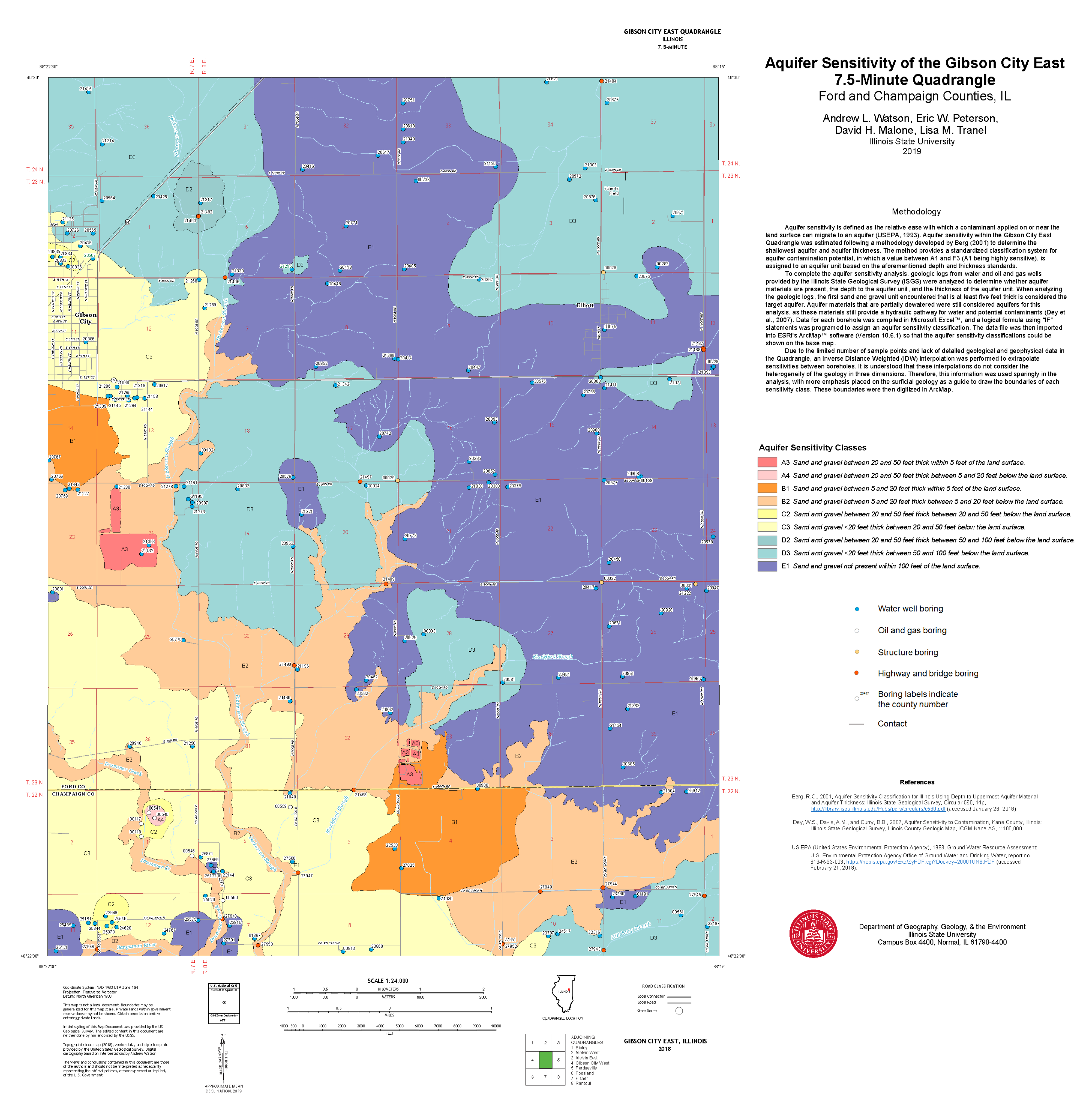
| Sensitivity Class | Description |
|---|---|
| A3 | Sand and gravel or high-permeability bedrock 6 to 15.3 m (20–50 ft) thick within 1.5 m (5 ft) of the land surface. |
| A4 | Sand and gravel or high-permeability bedrock 6 to 15.3 m (20–50 ft) thick between 1.5 and 6 m (5 and 20 ft) below the land surface. |
| B1 | Sand and gravel or high-permeability bedrock between 1.5 and 6 m (5 and 20 ft) thick within 1.5 m (5 ft) of the land surface. |
| B2 | Sand and gravel or high-permeability bedrock between 1.5 and 6 m (5 and 20 ft) thick between 1.5 and 6 m (5 and 20 ft) below the land surface. |
| C2 | Sand and gravel or high-permeability bedrock between 6 to 15.3 m (20–50 ft) thick between 6 to 15.3 m (20–50 ft) below the land surface. |
| C3 | Sand and gravel or high-permeability bedrock < 6 m (20 ft) thick between 6 to 15.3 m (20–50 ft) below the land surface. |
| D2 | Sand and gravel or high-permeability bedrock between 6 to 15.3 m (20–50 ft) thick between 15.3 and 30.5 m (50 and 100 ft) below the land surface. |
| D3 | Sand and gravel or high-permeability bedrock < 6 m (20 ft) thick between 15.3 and 30.5 m (50 and 100 ft) below the land surface. |
| E1 | Sand and gravel or high-permeability bedrock not present within 30.5 m (100 ft) of the land surface. |
© 2020 by the authors. Licensee MDPI, Basel, Switzerland. This article is an open access article distributed under the terms and conditions of the Creative Commons Attribution (CC BY) license (http://creativecommons.org/licenses/by/4.0/).
Share and Cite
Watson, A.; Peterson, E.W.; Malone, D.; Tranel, L. Geology and Aquifer Sensitivity of Quaternary Glacial Deposits Overlying a Portion of the Mahomet Buried Bedrock Valley Aquifer System. Hydrology 2020, 7, 69. https://doi.org/10.3390/hydrology7040069
Watson A, Peterson EW, Malone D, Tranel L. Geology and Aquifer Sensitivity of Quaternary Glacial Deposits Overlying a Portion of the Mahomet Buried Bedrock Valley Aquifer System. Hydrology. 2020; 7(4):69. https://doi.org/10.3390/hydrology7040069
Chicago/Turabian StyleWatson, Andrew, Eric W. Peterson, Dave Malone, and Lisa Tranel. 2020. "Geology and Aquifer Sensitivity of Quaternary Glacial Deposits Overlying a Portion of the Mahomet Buried Bedrock Valley Aquifer System" Hydrology 7, no. 4: 69. https://doi.org/10.3390/hydrology7040069
APA StyleWatson, A., Peterson, E. W., Malone, D., & Tranel, L. (2020). Geology and Aquifer Sensitivity of Quaternary Glacial Deposits Overlying a Portion of the Mahomet Buried Bedrock Valley Aquifer System. Hydrology, 7(4), 69. https://doi.org/10.3390/hydrology7040069


