Article

Estimation of Year of Construction of Bridges in Cambodia by Analyzing the Landsat Normalized Difference Water Index

1
Department of Civil Engineering, The University of Tokyo, Tokyo 113-8654, Japan
2
Institute of Industrial of Sciences, The University of Tokyo, Meguro, Tokyo 153-8505, Japan
*
Authors to whom correspondence should be addressed.
These authors contributed equally to this work.
Infrastructures 2023, 8(4), 77; https://doi.org/10.3390/infrastructures8040077
Submission received: 27 February 2023 / Revised: 10 April 2023 / Accepted: 11 April 2023 / Published: 13 April 2023

Abstract

:
Inspection data can be used to comprehend and plan effective maintenance of bridges. In particular, the year of initial construction is one of the most important criteria for formulating maintenance plans, making budget allocations, and estimating soundness. In an initial survey of bridges in Cambodia, it was concluded that the year of construction of only 54% of 2439 bridges surveyed is known, with the remaining 46% remaining unknown. In this research, Landsat satellite data is used to estimate the year of construction of these bridges. Landsat provides spatial spectral reflectance information covering more than 30 years, and for longer bridges this can be used to estimate the year of construction by visual judgement. However, limited image resolution means this is not possible for shorter bridges. Instead, a method using the Landsat Normalized Difference Water Index (NDWI) is used to estimate the year of construction. Three pixels are selected from Landsat image data in such a way that one lies on the current location of a bridge and two other reference pixels are placed on similar terrain at a certain distance perpendicular to the bridge axis. NDWI values are plotted over time for the three pixels and the difference in value between the bridge pixel and the two reference pixels is then compared. Before the bridge is constructed, all three pixels should have similar NDWI values, but after construction the value of the target bridge pixel should differ from the other two because the NDWI value of a bridge surface is different from that of the surrounding vegetation. By looking for this change, the year of construction of a bridge can be estimated. All the bridges in the Cambodian database are classified into three categories based on length (which affects their visibility in Landsat images) and year of construction is estimated. The results show that estimated year of construction has the same accuracy in all three categories.

1. Introduction

A very important aspect of bridge asset management and maintenance is a composite database containing related details of all the bridges, such as length, materials, date of construction, etc. [1]. During a recent analysis, Cambodian officials realized the importance of such a database and commenced a survey to collect this data for all road bridges in Cambodia. As part of the survey, each bridge was also inspected and components that make the bridge unsafe for passenger use or that may lead to collapse were identified. The first cycle of bridge inspection was conducted by Cambodian engineers under the management of the Road Infrastructure Department (RID) of the Ministry of Public Works and Transport (MPWT) between 2015 and 2017. This survey made clear that there are many gaps in the information available, year of construction being one of them. Out of 2439 bridges, the year in which 46% of them were constructed could not be identified due to lack of available documents and evidence.
Year of construction is one of the most important parameters of a bridge database. It is the basis for estimating the current and future condition and serviceability of a bridge as well as for risk prediction [2]. In case of Cambodia, a bridge is designed using specific design guidelines similar to other countries, which were generally updated every 5 to 10 years to reflect findings from recent disasters or changes in construction materials. Therefore, it is necessary to estimate the year of construction, to know information regarding the version of the design guidelines used, construction materials used, and the age of structure. Once the construction year along with design guidelines is estimated, expected life, bridge maintenance, and restoration can be planned according to the present deteriorated condition. Bridge age is also one of the components of the Markov Chain model for predicting the service life of a bridge [3]. Hence, there is urgent demand for a way to estimate the year of construction of these bridges effectively and accurately in order to complete the database and carry out effective maintenance.
This study addresses a new problem of estimating the construction year of a bridge and there have been no prior trials performed in this direction. Previous studies have estimated the deterioration rates of bridge elements [4,5] and service life estimation of bridges [6]. To estimate the construction year, it is necessary to have available some kind of data collected in the past that can be successfully analyzed to extract the time of construction of bridge. Many previous studies have used satellite data for extracting bridge features [7,8] and monitoring structural deformation and early warning systems via interferometry [9,10,11]. Similarly, a system for efficiently performing this analysis is needed for this study and one such system can be formulated using image data collected by Landsat satellites.
Landsat came about when the United States Geological Survey (USGS) proposed collecting data from a reliable source and utilizing it for environmental applications worldwide. This led to the Earth Resource Observation Satellite (EROS) project in 1966, which accomplished this goal with the launch of the Earth Resources Technology Satellite (ERTS-1). The satellite was renamed Landsat 1 on 23 July 1972. Subsequently, Landsat 2, 3, 4, 5, 7, and 8 came into operation in 1975, 1978, 1982, 1984, 1999, and 2013, respectively [12]. Unfortunately, Landsat 6 failed in 1993. For Landsat 1 to 3, the ground sampling interval was 80 m, i.e., one pixel in an image represented an area equivalent to 80 m × 80 m. This was upgraded to 30 m for Landsat 4 to 9 [13]. Due to limitations of the Landsat data collected from Cambodian geographical territory, this research uses Landsat 5 which provides data from 1988 to 2012 and Landsat 7 for 2000 to 2020. Therefore, this study uses Landsat 7 data after 2000 and Landsat 5 data before 2000. The comparison between Landsat 5 and 7 is out of the scope of this study and hence not carried out.
Landsat data is publicly available and routinely used for analyzing temporal and spatial variations in the environment. It takes 16 days for the satellite to make one set of data for the complete surface of the Earth [14]. Although application of this publicly available remote sensing data is common in fields such as urban land coverage and impervious surface mapping, its use in critical infrastructure management and monitoring remains rare. Previous research that has used open datasets includes bridge health monitoring [15] and railway infrastructure management [16,17] using SAR and deformation monitoring of dams using global navigation satellite systems [18,19]. The technique used in this study is bases upon Google Earth Engine (GEE) platform, a free cloud-based platform consisting of publicly available geospatial datasets, which is commonly used in the remote sensing field [20,21,22,23].
One way to estimate the construction year of a bridge is by visual inspection of Landsat images on a yearly basis; this is possible in the case of longer bridges (100 m or longer). However, for shorter bridges (30 m or shorter), the limited image resolution makes it difficult to visually detect the appearance of a bridge in the image. For these bridges, therefore, a different estimation technique is required. About 25% of the total sunlight falling on the Earth surface is reflected into the space. This reflected light is processed by Landsat sensors to capture data such as images, wavelengths which can be later processed to calculate indices and finally to study the characteristics of the reflecting surface.
The Normalized Difference Vegetation Index (NDVI) and Normalized Difference Water Index (NDWI) are two such indices that can be used for the purpose of this research. Both indices are calculated from the reflected wavelengths data collected to study the earth terrain surface property. NDVI represents the greenness of vegetation and can be used to comprehensively quantify changes in plant density [24]. The vegetation index, NDVI, ranges from −1 to 1 and can be used to classify the surface of earth into different categories such as rocky, sandy, fertile, and vegetation based on its value. Various studies have used NDVI to calculate fertile land, estimate Ulva prolifera, quantifying urban vegetation, etc.
On the other hand, NDWI is an indicator of water content in the reflecting surface such as soil, vegetation, and water bodies [25,26]. An investigation that compared NDVI and NDWI to estimate the water content of vegetation of corn and soybean fields concluded that NDWI better estimated the water content [27]. Another study utilized the NDWI index obtained from multispectral imagery to expose the standing water pools that assist breeding of mosquitoes in order to reduce the risks of serious diseases for humans; the results accurately predicted the locations of 78% of such pools of standing water [28]. Furthermore, NDWI was also chosen to analyze image from the Landsat Multispectral Scanner System, Thematic Mapper, and Enhanced Thematic Mapper Plus for estimating the different basin water areas in the Qingjiang River Basin, China [29]. A case study in Bihar, India, adopted NDWI analysis to evaluate the lineament of the flood-prone areas and the result clearly identify the effect of height on area downstream and upstream from the Koa-river [30]. Other applications of NDWI include detecting offshore drilling rigs [31], forest cover changes in Russia [32], monitor emerging archaeological sites in Iraq [33], and development of automated flood monitoring system [34].
The vegetation index, NDVI, can identify the surface terrain of earth while water index, NDWI, estimates the amount of water contents in the reflecting surface. Since the surface of a bridge is hard and dry compared to surrounding area, both indices can be used to identify the time of its existence. However, since most of the ridges are constructed over water streams such as rivers and surrounding is usually wet specially during the rainy season, NDWI is a better tool to distinguish the surface of a bridge from the wet and moist surrounding areas. This study uses time mapping of NDWI values to recognize bridges in Cambodia from their surroundings and thereby estimate the year of construction of those bridges. The methodology developed for this purpose is validated in this study by using it on bridges whose construction year is already known. For this purpose, the continuously processed NDWI value is collected, plotted on against time, and analyzed at the location of these known bridges.
As previously noted, long bridges are clearly visible in Landsat data as compared to short bridges and the year of construction can be visually recognized on Landsat images. Hence, a categorization of Cambodian bridges into three lengths is used: long bridges (length ≥ 100 m), medium bridges (20 m ≤ length < 100 m), and short bridges (length < 20 m). Firstly, a simple image analysis is performed to visually identify the appearance of each bridge in the Landsat image data, and then a detailed comparison of NDWI at the bridge location and its surroundings is performed. NDWI values at the bridge location are anticipated to be similar to those of its surroundings before construction. In contrast, the NDWI value at the bridge location is expected to clearly differ from the surroundings after construction of the bridge due to the change in surface. The authors use this method to estimate the year of construction of bridges where this data is not available. Although Cambodia is the focus of this study, the method is expected to be applicable to bridges all over the world.

2. Bridges in Cambodia

In Cambodia, there are 2439 bridges under the authority of the Road Infrastructure Department (RID) of the Ministry of Public Works and Transport (MPWT). There is a lack of critical information such as design drawings, as-built drawings, history of maintenance and repair, and year of construction for several of these bridges. To collect this data during the survey, inspectors used smart tablets to record all information about these bridges available at the site. For example, some bridges have a nameplate giving the name of the constructor, length, and year of construction. In other cases, the engineer in the provincial Department of Public Works and Transport was able to give information, while sometimes local residents were asked about the probable year of construction. However, the recorded year of construction can be wrong. For example, the year given on the nameplate might be based on the contract between the client and the constructor, which might differ from the actual date if the project was delayed or completed early. Records based on an engineer or local people are approximate and cannot be fully trusted.
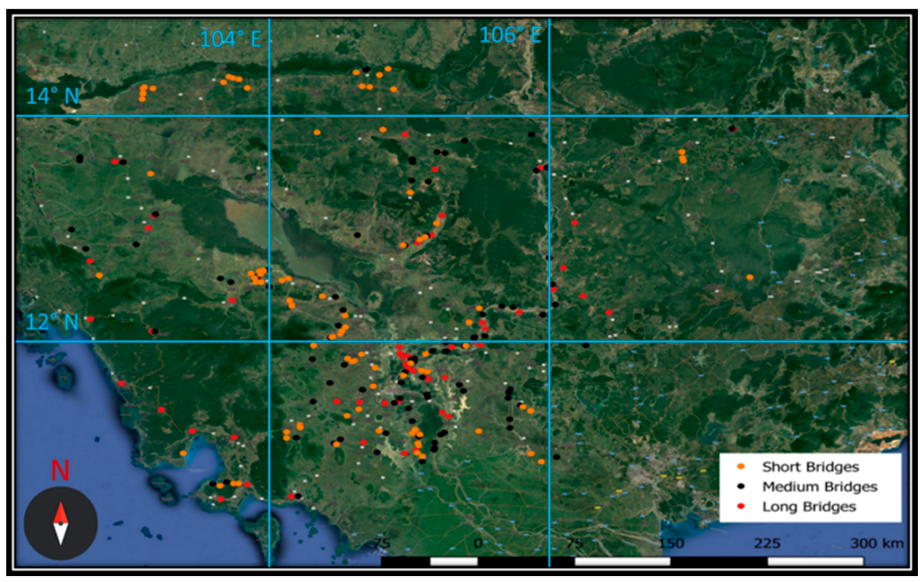
Following the analysis, it was concluded that for 1109 bridges, or about 46% of the total (Figure 1a), the year of construction is unknown. Concrete bridges account for 80% of the 2439 total (Figure 1b). After length categorization, it was observed that the ratio of unknown to known bridges is comparatively higher for the short bridge category compared to long and medium bridges (Figure 2a–c), indicating the need for systemic judgement over visual judgement. The intention in this work was to select 100 bridges with known year of construction to study from each category, but due to the limited number of long bridges (only 61), a total of 261 bridges were studied (Figure 3).

3. Methodology

3.1. Setting up of Measurement Points

This study uses the Google Earth Engine (GEE) for the objective of estimating construction year. A previously reported study used GEE as a platform for geospatially analyzing the world’s major areas with deforestation, flooding, drought, and farming problems [35]. The model used here involves the temporal segmentation of NDWI values from time-series Landsat data to indicate water bodies at a specific point.
Initially, a simple manual image analysis is performed by exporting the year-by-year Landsat images of the target bridge location and visually identifying the appearance of the bridge on the image. To illustrate this process, the Sre Ambel bridge of length 420 m (a long bridge) is selected as shown in Figure 4. It can be observed that bridge was not present in 2006 but can be seen in the 2007 image. Hence, it can be concluded that construction of the bridge took place during 2007. Similar images are shown for the Prek Kork bridge of length 72 m (a medium bridge) in Figure 5. From this figure it is clear that the year of construction cannot be visually estimated. This leads to the requirement for a methodology that works not only for long bridges, but also for medium and short bridges.
Since visual identification is not possible for medium and short bridges, a new methodology using the NDWI values is proposed in this study. In this method, the values of NDWI at a target point on the bridge and at control reference points are calculated and compared. A sample of the Landsat satellite image data showing the location of a target bridge and the reference points used in this study is shown in Figure 6, which also shows the grid size of the data, which is 30 m × 30 m.
The stepwise procedure for obtaining the reference points pertaining to a target bridge is shown in Figure 7. The first step is to identify the bridge location, which is already known from the bridge database. However, this location data is not accurate, and a more precise location needs to be defined. Therefore, the second step is to locate the end points of the existing bridge, as shown in Figure 6a. Consider the bridge as a line segment with these end points, which are accurately obtained from Google Earth’s latest high-resolution satellite data. The third step is then to determine the center point of the bridge line segment based on these end points. This center point is referred to as the target bridge. The fourth and final step is to determine the reference points. These are determined as two points lying on a line perpendicular to the line segment and on opposite sides of the bridge as shown in Figure 6b. A point to be noted here is that the grid size of Landsat data is 30 m × 30 m and the NDWI value will be same anywhere in the grid. If the reference points are within 30 m of target bridge point, they may lie on the same pixel as target bridge point and index value of both will be same. Hence, to keep the points distinctive and be able to identify the difference in NDWI value between the bridge and the reference points, it is necessary that the reference points be more than 30 m away from the target bridge. Based on this reasoning, the distance of the reference points from the bridge center is set at 35 m. This procedure is shown as a flow chart in Figure 7.
The NDWI index value, which is a function of green reflectance and near-infrared (NIR) reflectance is defined using Equation (1) [15]:
NDWI = (Green − NIR)/(Green + NIR)
Green reflectance has a wavelength range of 0.52–0.60 μm while NIR has a wavelength of 0.76–0.90 μm. The plot in Figure 8a represents the NDWI values for the Sre Ambel bridge (420 m long) over a number of years, with the NDWI of the target point plotted as a red line. The reference point values of NDWI are also plotted (in blue), with the upper value representing the reference point with the higher (maximum) index and the lower representing the lower (minimum) index; the range between the minimum and maximum NDWI values is shown as a blue shaded region. Variations in the NDWI value at reference points occurs mainly due to environmental factors that vary over time such as clouds, moisture condition, and vegetation variation. In the ideal case, if there is no construction activity at the target point during a certain time period, the NDWI value at the target point (red line) should lie within or very close to the NDWI range of the reference points (blue shaded region) for that period. After construction of a bridge, the change in reflectivity caused by the bridge deck should cause the NDWI value to suddenly change such that it lies outside the reference region. Figure 8b plots the difference between the NDWI value of the target point from that of the reference point value closer to the target point value. Observation of Figure 8b indicates that the NDWI year of construction of the Sre Ambel Bridge is 2008 even though the year predicted by visual analysis was 2007.

3.2. Judgment Criteria for Year of Construction

It is clear from Figure 8 that variations in target point and reference point values are not binary, but that changes in environmental conditions affect them. Thus, the trend line shown in Figure 8b may not always show a clear alteration in the NDWI index. This means that a judgement criterion is required to identify the year of construction of bridges using this method. Therefore, the trend line is studied for a few more bridges.
As the first case, the NDWI plots for the An Daung Bridge are studied. This bridge was thought to have been constructed in 2008. However, the NDWI index value of the target bridge (red line) lies inside the blue shaded region in the year 2008 and only starts to deviate in 2009, as shown in Figure 9, proving that the actual year of construction must be 2009.
The same technique is applied to the TaAok Bridge. The NDWI index value at the target bridge (red line) moves slightly outside the blue shaded region sometimes but always comes back within the shaded region. In this case, the year of construction is estimated to be within the period when the target value lies outside the blue shaded region continuously for at least four years, as shown in Figure 10. Both, the previously existing value in database and as estimated by this method, the year of construction for this bridge is 2006.

3.3. Limitations of the Proposed Methodology

The lack of Landsat satellite data before 1988 for Cambodia is a limitation of this method. Therefore, in cases where target bridge pre-dates the year 1988, estimation of the year of construction may not be feasible. In these cases, there is a difference in NDWI between the target and reference points throughout the time series of data, similar to the one as shown in Figure 11. Another possible explanation for such a variation is the replacement of old bridge by the construction of a new bridge. In these cases, the construction year of new bridge cannot be estimated as the difference in NDWI between the target and reference points will exist throughout the time. In both the above cases, this method estimates the year of construction to be 1988, the earliest possible date. However, the year of construction in the database for the Pot Drea bridge shown in Figure 11 is 2008. Thus, confirming the existence of an older bridge at the same location as the reason for limitation in estimation. Acknowledging these limitations, the NDWI index method is applied to the Cambodia bridge dataset and the results are presented in the next section.

3.4. Test Data

As mentioned earlier, the bridge data in this study is from the bridge database of Cambodia. The objective of this study is to test the efficiency and applicability of the NDWI index method. Therefore, the bridges selected for testing the application of the developed methodology are those whose construction year is already known. The construction year is first judged from the visual identification from satellite images and then the NDWI index method is applied. Table 1 illustrates the number of bridges whereas Figure 12 illustrates the histogram plots for the number of bridges in different length bands in the three categories.

4. Results

4.1. Long Bridges

A total of 61 long bridges were examined in this study. Detailed results for three selected bridges are discussed in this chapter. First is the Tra Peang Roung bridge (L = 480 m) which is not visible in the 2006 and 2007 satellite images but appears in images from the year 2008. Thus, visual inspection determines the year of construction as 2008 (Figure 13). Additionally, until the year 2008 the NDWI value of the target bridge matches that of the reference points, but thereafter the value diverges from the reference points (Figure 14). This change in NDWI value after the year 2008 can be attributed to construction of the bridge in 2008.
Second is the case of the Kom Pong Bay bridge (L = 240 m). These results are similar to those above. Satellite images from 2005 to 2007 show that the bridge appears after the year 2007, so visual inspection confirms the year of construction as 2007 (Figure 15). The NDWI comparison shows that the index value at the target (red line) sometimes falls slightly outside the blue shaded region until 2007. Then, from 2007 the red line separates from the blue shaded region, showing either the presence of some material covering the bridge or confirming bridge construction (Figure 16).
Lastly, in the case of the Prey Bang bridge (L = 100 m), visual identification was not possible using satellite images due to the poor quality of the images (Figure 17). The NDWI comparison shows a deviation between the target (red line) and reference points (blue shaded region) over the whole time period. This probably means that a new bridge was constructed at the same location as an older bridge (Figure 18).
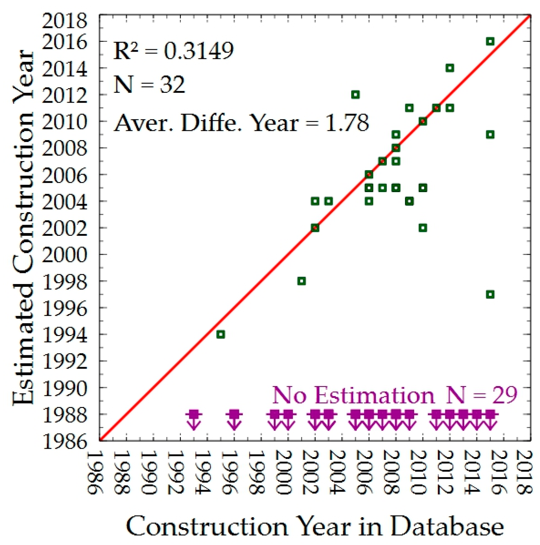
To validate the results of the NDWI method, the NDWI estimated year of construction for the 61 long-span bridges is plotted against the known year of construction from the Cambodian bridge database in Figure 19. The red line represents a linear relationship between the estimated construction year and the real one, the data points on red lines imply the exact estimation, the deviation from red line implying the estimation deviation with construction year in database. It can be observed that the year of construction could be estimated for 32 of the bridges, but no estimate was possible for the remaining 29 bridges. Points on the plot that fall on the regression (red) line represent bridges where the NDWI year of construction matches that is obtained from the database. The coefficient of determination (R2) value for this regression line is 0.3149, and the average difference in estimated year of construction is about 1.78 years, so it can be concluded that the results given by the NDWI index method are accurate (Figure 19).

4.2. Medium Bridges

A total of 100 medium bridges were studied and detailed results for three of them are presented in this section. Figure 20 shows satellite images of Thnol Dach bridge (L = 84 m), from which it is very difficult to identify the bridge and estimate its year of construction. However, even though the NDWI results (Figure 21) are a little complex to read, the year of construction can be estimated from them as 2010. In the period 2002 to 2006, the target bridge NDWI (red line) moves slightly out of the blue shaded region many times but always comes back into the region. However, these deviations arise only from December to January, which is the dry season in Cambodia. During the dry season, the water stream under bridge dries and patches of land become visible. This produces a slight deviation of NDWI value at target bridge and reference points during this season. Considering this, during this period, the bridge was absent between 2002 and 2006. From 2010, the target NDWI value starts actually deviating without the difference returning to zero, so this can be read as the year of construction.
The second case is Prek Ah Teang bridge (L = 36 m). The results are similar to those of the above bridge. The satellite images are unclear, and the bridge cannot be identified from them (Figure 22). In contrast, the NDWI results show that from 2000 to 2003 the red line lies within the blue shaded area whereas from the end of 2003 it almost always lies outside the blue shaded area, indicating that a bridge has been constructed at that location (Figure 23).
In the third case of O Thnol 3 bridge (L = 20 m), the bridge could not be recognized in the satellite images, so again a visual estimate of year of construction was not possible (Figure 24) using the images. However, the NDWI results show that the target bridge NDWI (red line) and the reference points (blue shaded region) differ from beginning to end. This is because a new bridge was reconstructed on the site of an older bridge (Figure 25).
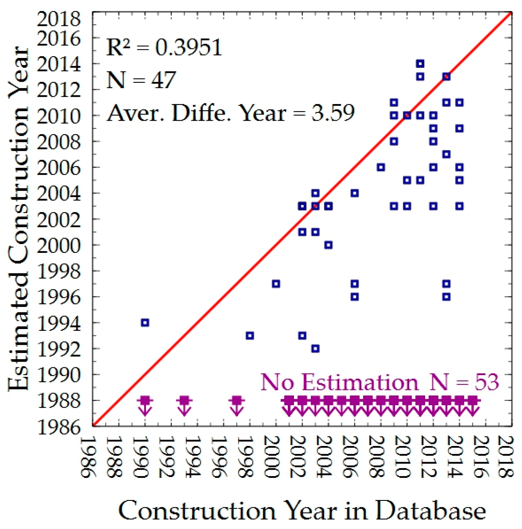
Figure 26 summarizes the year of construction for all the medium bridges. Out of the 100 medium bridges studied, the year could be estimated for 47 but was not possible for the remaining 53. The regression line represents agreement between the actual year of construction and the estimated one. The difference between commencement of construction and completion of the bridge (i.e., the construction period) may explain small deviations from this line. The value of coefficient of determination (R2) for the 47 bridges is 0.3951, and the average deviation from the red line is −3.59 years with the minus sign meaning that the estimated year of construction falls before the actual year of construction.

4.3. Short Bridges

This study estimates the year of construction for 100 short bridges. The results for three of them are explained in detail in this section. The satellite images of the first case, the Otaki bridge (L = 12 m), are shown in Figure 27 and the NDWI analysis results in Figure 28. It is clear that visual estimation is not possible from the satellite images due to the very low image resolution (30 m × 30 m) compared to size of bridge. However, from Figure 28a, it can be observed that the NDWI value for the target bridge moves slightly outside the shaded blue reference region many times but always comes back except in the year 2005, when the red line clearly deviates from the blue shaded region. The presence of the bridge deck at the target point after 2005 is a possible explanation of this behavior.
The second case is the Poum Krouch bridge (L = 12 m) whose results are similar to the previous bridge. The satellite image is not clear, and the bridge cannot be identified (Figure 29). In contrast, the NDWI results clearly allow the year of construction to be estimated as 2014, because the red line remains permanently outside the blue shaded region after 2014 (Figure 30).
The third case of the Ta Kouy1 bridge (L = 5 m) has similar results. The bridge cannot be identified from the satellite images (Figure 31), but the NDWI results give an estimated year of construction of 1993, which is when the red line moves permanently outside the blue shaded region (Figure 32).
The results for all the short bridges are summarized in Figure 33, which shows that the year of construction could be estimated for 62 bridges but was not possible for the remaining 38. The value of coefficient of determination (R2) for the 62 bridges is 0.4095 and the average deviation of these bridges from the red line is 1.43 years. Hence, it can be said that the accuracy is similar to that of the long bridges since the coefficient of determination is similar.

5. Conclusions

The achievement of this study is to formulate two new methods for estimating the year of construction of a bridge for which it is unknown or uncertain. The first is based on its visual appearance on satellite images, but because of satellite image resolution it is suitable only for estimating long bridges. The NDWI method is new and innovative that allows estimation for shorter bridges too.
The proposed method was applied to bridges In Cambodia. Even in cases where medium length and short bridges cannot be estimated visually from the satellite images, an estimated year of construction could be obtained with NDWI method and the coefficient of determination (R2) was similar for long bridges (0.3149), medium bridges (0.3951), and short bridges (0.4095) indicating the similar accuracy. The average deviation of estimated year is 1.78, 3.59, and 1.43 years for long, medium, and short bridges, respectively, indicating a better estimation for shorter bridges than medium bridges.
Additionally, the gap in estimated and database construction year illustrated by dispersed data points in Figure 19, Figure 26 and Figure 33 can be explained by the fact that the planned construction year is recorded in database, which might not be the actual construction year due to delays in construction.
Hence, the year of construction of the bridge could be estimated. The results where the estimated year of construction is 1988 could mean two things: either the bridge was constructed before 1988 and due to limitations of the Landsat dataset the year cannot be estimated, or the bridge was upgraded, with a new bridge replacing an older bridge at the same location. This method is shown to be capable of estimating the year if the bridge is constructed in a new location, but a limitation is an inability to derive an estimate if an older bridge is rebuilt or replaced in the same location.
Considering future directions for this study, a mathematical criterion can be developed that is used to automatically judge the construction year of bridge from the NDWI plot. The application of latest technology such as Machine Learning for this auto estimation technique could also be explored in future where the system is trained with some part of available data and then tested on the remaining data. The analysis of gap between estimated and database construction year is also one of the future scopes of this study.

Author Contributions

Analyzing the data and draft, V.S.K. and E.S.; Landsat data acquisition, P.M. and W.T.; Research idea and organization of research, K.N. All authors have read and agreed to the published version of the manuscript.

Funding

This research received no external funding.

Data Availability Statement

Restrictions apply to the availability of these data. Data was obtained from Road Infrastructure Department, Ministry of Public Works and Transport, Cambodia and are available from the corresponding authors with the permission of Road Infrastructure Department, Ministry of Public Works and Transport, Cambodia.

Acknowledgments

The authors wish to acknowledge the support from the Road Infrastructure Department, Ministry of Public Works and Transport, Cambodia which provided the bridge database.

Conflicts of Interest

The authors declare no conflict of interest.

References

  1. Pregnolato, M. Bridge safety is not for granted—A novel approach to bridge management. Eng. Struct. 2019, 196, 109193. [Google Scholar] [CrossRef]
  2. Jiang, Y. The Development of Performance Prediction and Optimization Models for Bridge Management Systems. Ph.D. Thesis, Purdue University, West Lafayette, Indiana, 1990. [Google Scholar]
  3. Jiang, Y.; Sinha, K.C. Bridge service life prediction model using the Markov chain. Transp. Res. Record 1989, 1223, 24–30. [Google Scholar]
  4. Agrawal, A.K.; Kawaguchi, A.; Chen, Z. Deterioration Rates of Typical Bridge Elements in New York. J. Bridg. Eng. 2010, 15, 419–429. [Google Scholar] [CrossRef]
  5. Bulusu, S.; Sinha, K.C. Comparison of Methodologies to Predict Bridge Deterioration. Transp. Res. Rec. J. Transp. Res. Board 1997, 1597, 34–42. [Google Scholar] [CrossRef]
  6. Jeong, Y.; Kim, W.; Lee, I.; Lee, J. Bridge service life estimation considering inspection reliability. KSCE J. Civ. Eng. 2016, 21, 1882–1893. [Google Scholar] [CrossRef]
  7. Soergel, U.; Thiele, A.; Gross, H.; Thoennessen, U. Extraction of Bridge Features from high-resolution InSAR Data and optical Images. In Proceedings of the 2007 Urban Remote Sensing Joint Event, Paris, France, 11–13 April 2007; pp. 1–6. [Google Scholar] [CrossRef]
  8. Abraham, L.; Sasikumar, M. Analysis of Satellite Images for the Extraction of Structural Features. IETE Tech. Rev. 2014, 31, 118–127. [Google Scholar] [CrossRef]
  9. Nettis, A.; Massimi, V.; Nutricato, R.; Nitti, D.O.; Samarelli, S.; Uva, G. Satellite-based interferometry for monitoring structural deformations of bridge portfolios. Autom. Constr. 2023, 147, 104707. [Google Scholar] [CrossRef]
  10. Macchiarulo, V.; Milillo, P.; Blenkinsopp, C.; Giardina, G. Monitoring deformations of infrastructure networks: A fully automated GIS integration and analysis of InSAR time-series. Struct. Health Monit. 2022, 21, 1849–1878. [Google Scholar] [CrossRef]
  11. Cusson, D.; Rossi, C.; Ozkan, I.F. Early warning system for the detection of unexpected bridge displacements from radar satellite data. J. Civ. Struct. Health Monit. 2020, 11, 189–204. [Google Scholar] [CrossRef]
  12. A Brief History of the Landsat Program; December 1997; USGS Fact Sheet 084-97. Available online: https://www.usgs.gov/ (accessed on 1 April 2023).
  13. Landsat Satellite Missions U.S Geological Survey Official Homepage. Available online: https://www.usgs.gov/land-resources/nli/landsat/landsat-satellite-missions?qt-science_support_page_related_con=2#qt-science_support_page_related_con (accessed on 19 November 2019).
  14. Landsat Acquisition Tool, U.S Geological Survey Official Homepage. Available online: https://landsat.usgs.gov/landsat_acq (accessed on 3 December 2019).
  15. Milillo, P.; Giardina, G.; Perissin, D.; Milillo, G.; Coletta, A.; Terranova, C. Pre-Collapse Space Geodetic Observations of Critical Infrastructure: The Morandi Bridge, Genoa, Italy. Remote Sens. 2019, 11, 1403. [Google Scholar] [CrossRef] [Green Version]
  16. Haack, B.; Messina, J. Monitoring wetland changes with remote sensing: An East African example. Environ. Manag. 1996, 20, 411–419. [Google Scholar] [CrossRef]
  17. Chang, L.; Dollevoet, R.; Hanssen, R. Railway Infrastructure Monitoring using Satellite Radar Data. Int. J. Railw. Technol. 2014, 3, 79–91. [Google Scholar] [CrossRef]
  18. Brekke, C.; Solberg, A.H. Oil spill detection by satellite remote sensing. Remote Sens. Environ. 2005, 95, 1–13. [Google Scholar] [CrossRef]
  19. Montillet, J.-P.; Szeliga, W.M.; Melbourne, T.I.; Flake, R.M.; Schrock, G. Critical Infrastructure Monitoring with Global Navigation Satellite Systems. J. Surv. Eng. 2016, 142, 04016014. [Google Scholar] [CrossRef] [Green Version]
  20. Zhang, G.; Wu, M.; Wei, J.; He, Y.; Niu, L.; Li, H.; Xu, G. Adaptive Threshold Model in Google Earth Engine: A Case Study of Ulva prolifera Extraction in the South Yellow Sea, China. Remote Sens. 2021, 13, 3240. [Google Scholar] [CrossRef]
  21. Yu, W.; Zhou, W.; Dawa, Z.; Wang, J.; Qian, Y.; Wang, W. Quantifying Urban Vegetation Dynamics from a Process Perspective Using Temporally Dense Landsat Imagery. Remote Sens. 2021, 13, 3217. [Google Scholar] [CrossRef]
  22. John, E.; Bunting, P.; Hardy, A.; Silayo, D.; Masunga, E. A Forest Monitoring System for Tanzania. Remote Sens. 2021, 13, 3081. [Google Scholar] [CrossRef]
  23. Chamberlain, D.; Phinn, S.; Possingham, H. Mangrove Forest Cover and Phenology with Landsat Dense Time Series in Central Queensland, Australia. Remote Sens. 2021, 13, 3032. [Google Scholar] [CrossRef]
  24. Landsat Surface Reflectance-Derived Spectral Indices, Landsat Normalized Difference Vegetation Index. U.S Geological Survey Official Homepage. Available online: https://www.usgs.gov/land-resources/nli/landsat/landsat-normalized-difference-vegetation-index?qt-science_support_page_related_con=0#qt-science_support_page_related_con (accessed on 3 December 2019).
  25. Gao, B.-C. NDWI—A normalized difference water index for remote sensing of vegetation liquid water from space. Remote Sens. Environ. 1996, 58, 257–266. [Google Scholar] [CrossRef]
  26. Xu, C.; Qu, J.J.; Hao, X.; Wu, D. Monitoring Surface Soil Moisture Content over the Vegetated Area by Integrating Optical and SAR Satellite Observations in the Permafrost Region of Tibetan Plateau. Remote Sens. 2020, 12, 183. [Google Scholar] [CrossRef] [Green Version]
  27. Chen, D.; Jackson, T.; Li, F.; Cosh, M.; Walthall, C.; Anderson, M. Estimation of vegetation water content for corn and soybeans with a normalized difference water index (NDWI) using Landsat Thematic Mapper data. In Proceedings of the 2003 IEEE International Geoscience and Remote Sensing Symposium, Toulouse, France, 21–25 July 2003; IEEE: New York, NY, USA, 2003; Volume 4, pp. 2853–2856. [Google Scholar] [CrossRef]
  28. McFeeters, S.K. Using the Normalized Difference Water Index (NDWI) within a Geographic Information System to Detect Swimming Pools for Mosquito Abatement: A Practical Approach. Remote Sens. 2013, 5, 3544–3561. [Google Scholar] [CrossRef] [Green Version]
  29. Du, Z.; Linghu, B.; Ling, F.; Li, W.; Tian, W.; Wang, H.; Gui, Y.; Sun, B.; Zhang, X. Estimating surface water area changes using time-series Landsat data in the Qingjiang River Basin, China. J. Appl. Remote Sens. 2012, 6, 063609. [Google Scholar] [CrossRef]
  30. Jain, S.K.; Singh, R.D.; Jain, M.; Lohani, A.K. Delineation of Flood-Prone Areas Using Remote Sensing Techniques. Water Resour. Manag. 2005, 19, 333–347. [Google Scholar] [CrossRef]
  31. Zhu, H.; Jia, G.; Zhang, Q.; Zhang, S.; Lin, X.; Shuai, Y. Detecting Offshore Drilling Rigs with Multitemporal NDWI: A Case Study in the Caspian Sea. Remote Sens. 2021, 13, 1576. [Google Scholar] [CrossRef]
  32. Khatancharoen, C.; Tsuyuki, S.; Bryanin, S.; Sugiura, K.; Seino, T.; Lisovsky, V.; Borisova, I.; Wada, N. Long-Time Interval Satellite Image Analysis on Forest-Cover Changes and Disturbances around Protected Area, Zeya State Nature Reserve, in the Russian Far East. Remote Sens. 2021, 13, 1285. [Google Scholar] [CrossRef]
  33. Titolo, A. Use of Time-Series NDWI to Monitor Emerging Archaeological Sites: Case Studies from Iraqi Artificial Reservoirs. Remote Sens. 2021, 13, 786. [Google Scholar] [CrossRef]
  34. Wieland, M.; Martinis, S. A Modular Processing Chain for Automated Flood Monitoring from Multi-Spectral Satellite Data. Remote Sens. 2019, 11, 2330. [Google Scholar] [CrossRef] [Green Version]
  35. Gorelick, N. Google Earth Engine. In Proceedings of the EGU General Assembly Conference Abstracts, Vienna, Austria, 7–12 April 2013; Volume 15, p. 11997. [Google Scholar]
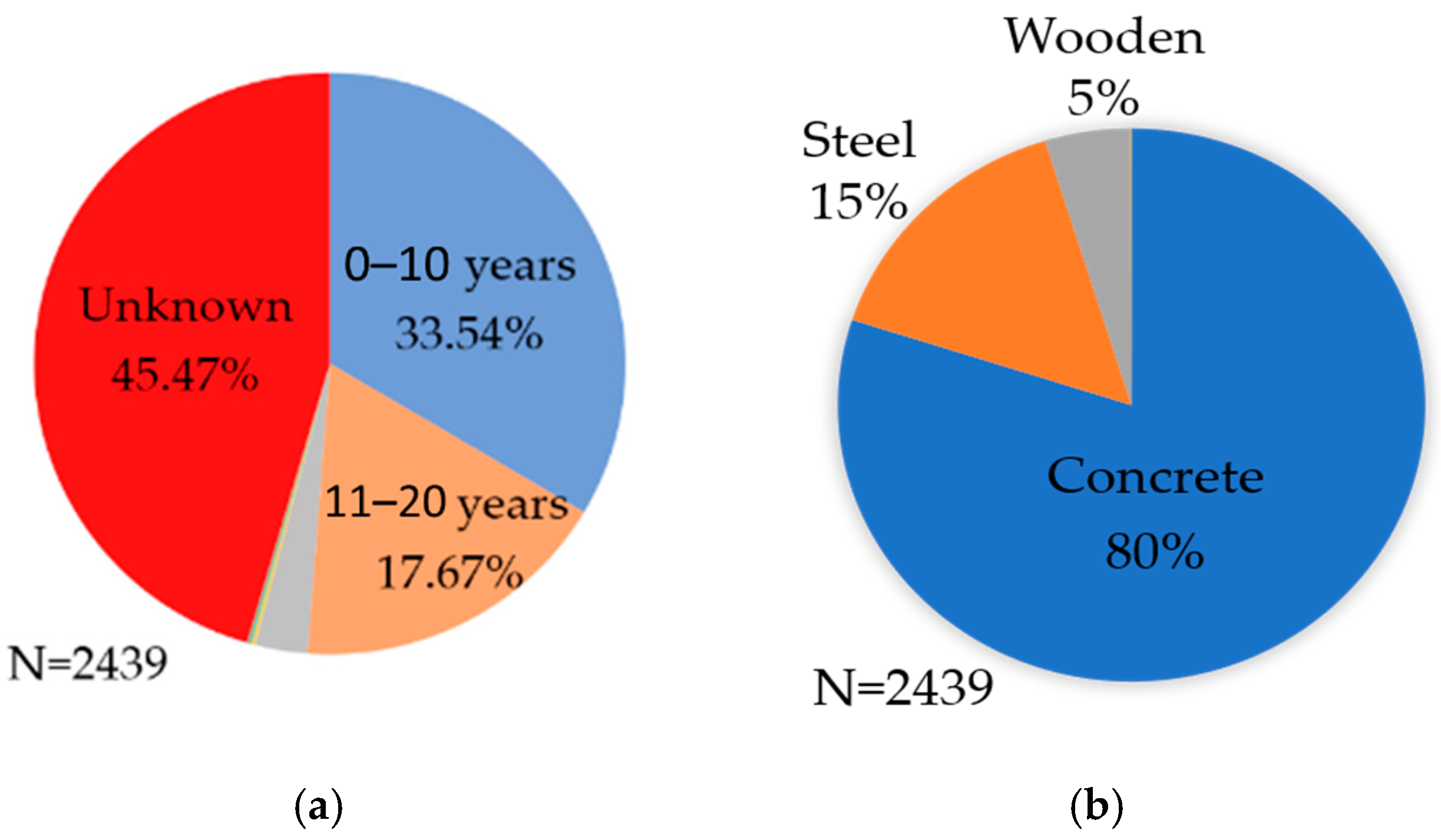
Figure 1. (a) Age of existing bridges; (b) classification based on construction material.
Infrastructures 08 00077 g001
Figure 2. The percentage of bridges with known and unknown year of construction: (a) long bridges (length ≥ 100 m), (b) medium bridges (20 m ≤ length < 100 m), and (c) short bridges (length < 20 m).
Infrastructures 08 00077 g002
Figure 3. Location of the 261 bridges selected for this study in Cambodia (short, medium and long bridges combined).
Infrastructures 08 00077 g003
Figure 4. Yearly Landsat images of the Sre Ambel (L = 420 m) bridge. The appearance of the bridge in the 2007 image indicates that the year of construction was 2007.
Infrastructures 08 00077 g004
Figure 5. Yearly Landsat images of the Prek Kork bridge (L = 72 m). Year of construction of this medium length bridge cannot be judged because of the poor image resolution.
Infrastructures 08 00077 g005
Figure 6. (a) Inputting the bridge location (from end to end of the bridge); (b) bridge location using the end points from Figure 7a and reference points.
Infrastructures 08 00077 g006
Figure 7. Flow chart for determining the location of target bridge and reference points.
Infrastructures 08 00077 g007
Figure 8. (a) Variation in NDWI index value at the target bridge (point) and reference points over time for the Sre Ambel Bridge; (b) re-visualization of (a) showing difference between NDWI of target and that of the closest reference point.
Infrastructures 08 00077 g008
Figure 9. (a) Variation in NDWI index value of the target bridge (point) and the reference points for the An Daung Bridge; (b) re-visualization of (a) showing difference between NDWI value of target and that of the closest reference point.
Infrastructures 08 00077 g009
Figure 10. (a) Variation of NDWI index value of the target bridge (point) and the reference points for the TaAok Bridge; (b) re-visualization of (a) showing difference between NDWI value of target and that of the closest reference point.
Infrastructures 08 00077 g010
Figure 11. (a) Variation of NDWI index value of the target bridge (point) and the reference points for the Pot Drea bridge; (b) re-visualization of (a) showing difference between NDWI value of target and that of the closest reference point.
Infrastructures 08 00077 g011
Figure 12. A histogram of the length of bridges in each category.
Infrastructures 08 00077 g012
Figure 13. Satellite images of Tra Peang Roung bridge, from which it can be clearly observed that the bridge was constructed in 2008.
Infrastructures 08 00077 g013
Figure 14. (a) Deviation of NDWI value from reference points (blue shaded region) for the Tra Peang Roung bridge; (b) re-visualization of (a) showing the NDWI difference, showing that it was constructed in 2008.
Infrastructures 08 00077 g014
Figure 15. Satellite images of Kom Pong Bay bridge from which it can be clearly observed that the bridge was constructed in 2007.
Infrastructures 08 00077 g015
Figure 16. (a) NDWI results for Kom Pong Bay bridge, which indicate the year of construction to be 2007 based on deviation from the reference points; (b) re-visualization of (a) showing the NDWI difference; the change in 2007 is clear.
Infrastructures 08 00077 g016
Figure 17. Satellite images of Prey Bang bridge; low image quality means the year of construction cannot be judged.
Infrastructures 08 00077 g017
Figure 18. (a) NDWI results for Prey Bang bridge, from which 1988 is estimated as the year of construction because the NDWI values differ from the beginning (as explained in Section 3.2); (b) re-visualization of (a) showing the NDWI difference; no clear change is apparent.
Infrastructures 08 00077 g018
Figure 19. Comparison of the database and estimated years of construction of the 61 bridges. Plotted points are not far from the red line, indicating good accuracy.
Infrastructures 08 00077 g019
Figure 20. Satellite images of the Thnol Dach bridge from which the year of construction cannot be judged.
Infrastructures 08 00077 g020
Figure 21. (a) NDWI results for the Thnol Dach bridge from which it is estimated that the bridge was constructed in 2010; (b) re-visualization of (a) showing the NDWI difference; a clear change is apparent.
Infrastructures 08 00077 g021
Figure 22. Satellite images of the Prek Ah Teang bridge from which the year of construction cannot be judged.
Infrastructures 08 00077 g022
Figure 23. (a) NDWI results for the Preak Ah Teang bridge from which it is estimated that the bridge was constructed in 2003 based on the deviation of the target NDWI from the blue shaded region; (b) re-visualization of (a) showing the NDWI difference; a clear change is apparent.
Infrastructures 08 00077 g023
Figure 24. Satellite images of the O Thnol 3 bridge from which the year of construction cannot be judged.
Infrastructures 08 00077 g024
Figure 25. (a) NDWI results for the O Thnol 3 bridge from which it is estimated that the bridge was constructed in 1988 because there is an NDWI difference from the beginning of the analysis; (b) re-visualization of (a) showing the NDWI difference from 1988.
Infrastructures 08 00077 g025
Figure 26. Comparison of the database and estimated years of construction of the 100 medium bridges. The plotted points are not very far from the red line, which indicates good accuracy.
Infrastructures 08 00077 g026
Figure 27. Satellite images of Otaki bridge from which the year of construction cannot be judged.
Infrastructures 08 00077 g027
Figure 28. (a) NDWI results for the O Ta Ki bridges, from which the year of construction is estimated to be 2005; (b) re-visualization of (a) showing a sudden NDWI deviation in 2005.
Infrastructures 08 00077 g028
Figure 29. Satellite images of the Poum Krouch bridge from which the year of construction cannot be judged.
Infrastructures 08 00077 g029
Figure 30. (a) NDWI results for the Poum Krouch bridge, from which the year of construction is estimated to be 2014; (b) re-visualization of (a) showing a sudden NDWI deviation in 2014.
Infrastructures 08 00077 g030
Figure 31. Satellite images of the Takoy 1 bridge, from which the year of construction cannot be judged.
Infrastructures 08 00077 g031
Figure 32. (a) NDWI results for the Ta Koy 1 bridge, from which the year of construction is estimated to be 1993; (b) re-visualization of (a) showing a sudden NDWI deviation in 1993.
Infrastructures 08 00077 g032
Figure 33. Comparison of the database and estimated years of construction of 100 short bridges. The plotted points are not far from the red line, indicating good accuracy.
Infrastructures 08 00077 g033
Table 1. List of bridges used in this study.
Bridge CategoryNo. of BridgesLength (m)
Long Bridge61(Bridges ≥ 100)
Medium Bridge100(100 > Bridges ≥ 20)
Short Bridge100(Bridges < 20)
Disclaimer/Publisher’s Note: The statements, opinions and data contained in all publications are solely those of the individual author(s) and contributor(s) and not of MDPI and/or the editor(s). MDPI and/or the editor(s) disclaim responsibility for any injury to people or property resulting from any ideas, methods, instructions or products referred to in the content.