1. Introduction
The recent development dynamics of urban centers, stimulated by the needs of a population increasingly motivated by economic and social reasons to live in large cities [
1,
2], have led to a substantial increase in the impermeable surface and a relative alteration of the natural hydrogeological cycle. It was possible to observe, therefore, a visible reduction in the percentage of infiltration, evapotranspiration and groundwater recharge [
3].
In particular, in some contexts already characterized by a high degree of vulnerability, such as the Italian territory, this inevitably led to a rapid increase in the hydrogeological risk for the population and the environment [
4].
This scenario, therefore, mainly characterized by phenomena such as urban flooding and heat islands, has forced the administrations to more frequently deal with problems linked to the inability of traditional urban drainage systems to efficiently and sustainably dispose of rainwater.
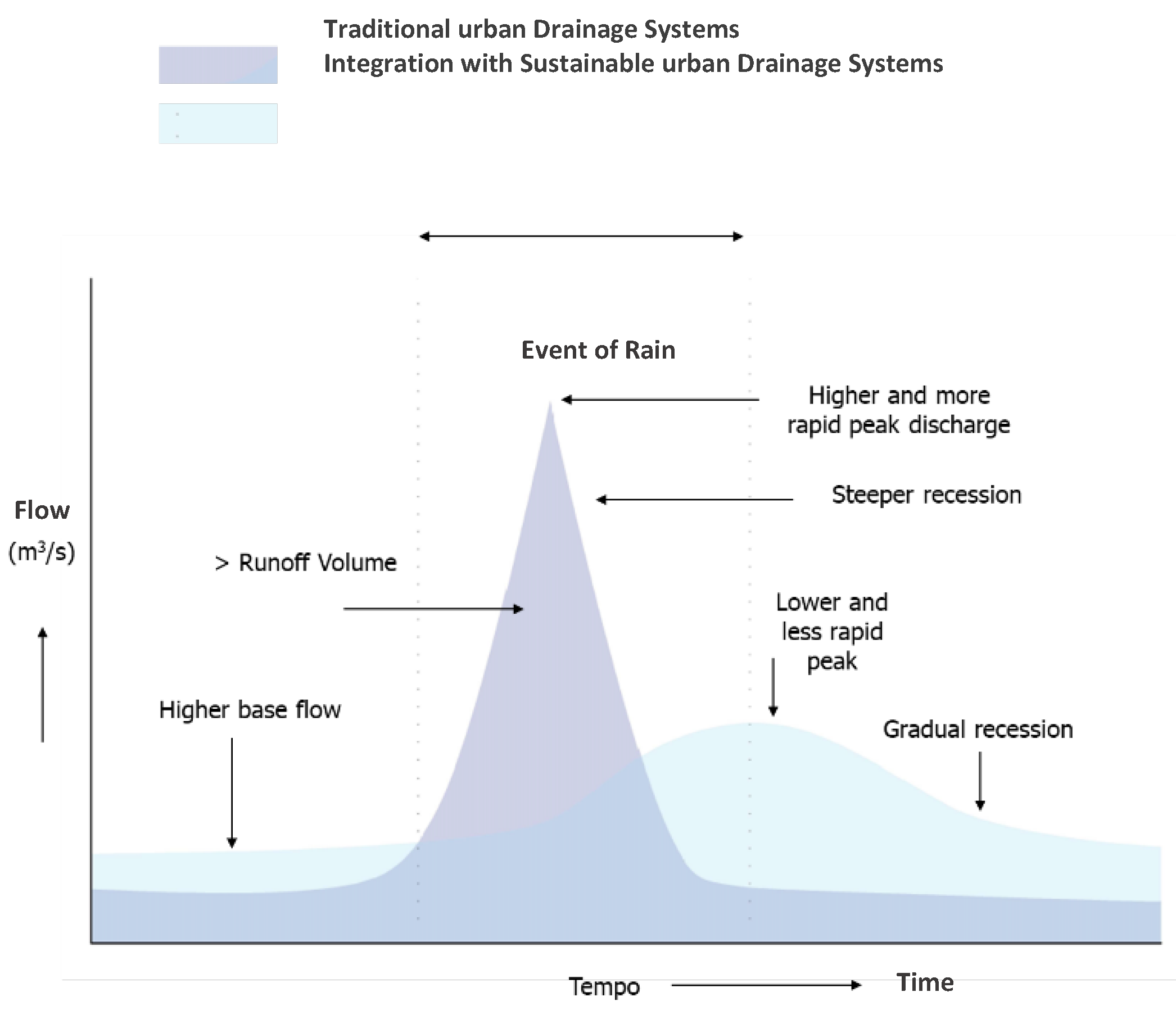
Several laws currently in force require compliance with the quantitative and qualitative limits to stormwater volumes to be discharged into watercourses (Lombardia Regional Low 15 March 2016, n. 4) but, in parallel with a “regulatory” approach, integrated strategies are increasingly being developed (
Figure 1). In these kind of strategies, sustainable technologies, able to reduce the flows conveyed in the network and to put into practice policies of redevelopment of the territory, come into play.
It is therefore considered essential to change the approach to urban planning, or to modify the already consolidated urban contexts using sustainable drainage technologies able to bring urban systems back to a configuration that is more similar to the one prior to intensive construction, and to the natural pattern. A fundamental role in the implementation of this strategy is carried out by Sustainable Drainage Systems (SuDS), whose basic principle is the management of rainwater at source through the implementation of prevention, mitigation and treatment strategies [
5].
This study, therefore, starting from an existing project proposal realized by Studio Majone Ingegneri Associati (Milan), IRIDRA (Florence), Studio Gioia Gibelli (Milan), Studio Idrogeotecnico (Milano) and funded by PoliS-Lombardia (Regional Institute for supporting Lombardia Region policies), aims to evaluate the benefits deriving from the widespread implementation of green infrastructures in the industrial area of Sesto Ulteriano (MI), through a comparison between a scenario that represents the current configuration of the drainage network, and an ideal scenario in which different SuDS techniques (rain gardens, ditches and draining stalls, floodable squares, cisterns-planters) have been implemented.
The work here presented is an excerpt form a large-scale project which provided for several analysis (hydrological and hydraulics) on different Sustainable Drainage scenarios. Specifically, this work aim at investigating the results, in terms peak flow and total runoff volume reduction, in a particular scenario in which sustainable urban systems cover the 10% of the study area and are fully connected with the urban context (maximum optimization scenario). In addition, the study focuses on the analysis of LID performance under severe weather conditions and for this reason they are tested under 5 and 10 years return period rainfall events.
2. Materials and Methods
The in-depth study of the area under analysis (a catchment of about 300 ha in the industrial context of Sesto Ulteriano), the choice and punctual location of sustainable infrastructures (10% of the study area) in the different homogeneous areas and the construction of a drainage network model able to represent reality using only very few basic simplifying hypotheses, can certainly be considered the real strengths of this work.
In particular, an accurate analysis of study area, included in the municipal territory of San Giuliano Milanese and subdivided for study reasons into 5 different macro-basins (
Figure 2b), allowed for the definition of reference models on the basis of which to articulate diffuse drainage intervention. Specifically, four models have been identified with their respective areas of interest: an industrial area model (building, parking areas, squares, flower beds and smaller green areas), a road model (roadways, sidewalks, parking lots in line), a green areas model and large permeable spaces (parks, uncultivated areas within the urban fabric, green strips belonging to the most important transport infrastructures and permeable or non-permeable areas inside road roundabouts) and a model of residential areas (buildings). For each of the components, different types of sustainable drainage infrastructures have been identified, designed and placed.
Starting from a modelling scenario of the Sesto Ulteriano drainage network (1148 nodes, 1141 pipelines for a total of 36 km of network), carried out by Studio Majone, on the basis of data and information provided by the managing body (CAP Group), steps were taken to implement the different types of SuDS that fell in each sub-basin of the sewer (
Figure 2a). To this end, therefore, the software SWMM5 of the US Environmental Protection Agency was used.
Comparing the information contained in the Storm Water Management Model 5 file, in particular those regarding the distribution on the territory of the sub-basins of the drainage network, and those relating to the spatial distribution of the different types of sustainable technologies available in Quantum GIS, it was possible to derive the areas of each SuDS to be attributed to each sub-basin.
Given the size of the study area, it was necessary to set up a semi-automatic procedure aimed at calculating and assigning parameters and areas where sustainable infrastructures are to be allocated within each sub-basin of the sewage network. Numerous checks were carried out manually by comparing the data available on the Quantum GIS model and that made in Storm Water Management Model.
3. Results
In particular, it is considered appropriate to present the results relating to the simulation of the effects of two synthetic rain event, one characterized by T = 10 years, and the other characterized by T = 5 years, in order to gather some information about the behavior of these technologies, in the case of critical events for traditional drainage systems.
Once the interest return periods have been chosen and the intensity-duration-frequency curves (IDF curves) valid for the study area have been identified (data of the Regional Environmental Protection Association of the Lombardy Region were fundamental in this regard), it was decided to use a synthetic hyetograph of the Chicago type, with a duration of 9 hours and peak at 0.3 of duration. The simulation outputs made it possible to identify, for the two different rainfall scenarios (T = 5, 10) and for both the models, traditional (T) and with Sustainable Systems (S), the maximum flow (Qmax) and the total volume (Vtot) of runoff from each of the outfalls of the sewer system. Finally, comparing the results, it was possible to calculate a percentage of reduction (D) of the analyzed parameters following the implementation of SuDS (
Table 1).
From the results shown in
Table 1, it is possible to highlight a visible reduction of maximum flow and total volume, following the widespread implementation of sustainable drainage infrastructures (mean reductions are all above 70%). It is essential to remember that the SuDS scenario here tested can be considered a scenario of “maximum optimization” of the urban area because SuDS cover 10% of the surface and are fully connected. This is the reason why we can observe considerable retention values.
These infrastructures seem to be more effective, especially in terms of total volume reduction, in the case of lower return periods (+5%) but, generally, there are not significant differences. This is mainly the result of the choice of testing these infrastructures under severe rainfall condition under which we observe only one of the extremes of the retention curves.
It also occurs that some outfalls show a greater reduction than others, due to their particular position in urban areas with greater retrofitting potential (
Figure 3).
4. Conclusions
In this study, the assessment of the benefits deriving from the widespread implementation of SuDS in the industrial area of Sesto Ulteriano has been made. Using EPA SWMM5 software, the behavior of the drainage network in two different scenarios (with and without SuDS) was simulated, in order to understand the differences between the current configuration of the drainage network, and an ideal scenario where SuDS have been implemented.
Simulation outputs carried out using synthetic rainfall characterized by return period of 5 and 10 years, allowed to compare the two different scenarios in terms of peak flow and total volume. Results showed a great performance of SuDS both in peak flow and total volume reduction (PEAK FLOW: 79% for T = 5, 78% for T = 10; TOTAL VOLUME: 77% for T = 5, 72% for T = 10). As expected, the scenario here presented (maximum urban surface and performance optimization), led us to positive results.
Further simulations are needed to study the performance of these technologies under different rain conditions, but the results obtained so far surely suggest that SuDS can be considered an effective sustainable solution, able to support traditional drainage systems in the management of stormwater, and also to provide other additional benefits in urban centers.


