Article

Fight against Future Pandemics: UAV-Based Data-Centric Social Distancing, Sanitizing, and Monitoring Scheme

1
Department of Computer Science and Engineering, Institute of Technology, Nirma University, Ahmedabad 382481, India
2
Centre for Inter-Disciplinary Research and Innovation, University of Petroleum and Energy Studies, P.O. Bidholi Via-Prem Nagar, Dehradun 248007, India
3
Software Engineering Department, College of Computer and Information Sciences, King Saud University, Riyadh 12372, Saudi Arabia
4
Computer Science Department, Community College, King Saud University, Riyadh 11437, Saudi Arabia
5
Department of Building Services, Faculty of Civil Engineering and Building Services, Technical University of Gheorghe Asachi, 700050 Iași, Romania
6
National Research and Development Institute for Cryogenic and Isotopic Technologies—ICSI Rm., Vâlcea, Uz-inei Street, No. 4, P.O. Box 7 Râureni, 240050 Rm. Vâlcea, Romania
7
Doctoral School, University Politehnica of Bucharest, Splaiul Independentei Street, No. 313, 060042 Bucharest, Romania
8
Faculty of Electrical Engineering and Computer Science, Ștefan cel Mare University, 720229 Suceava, Romania
*
Authors to whom correspondence should be addressed.
Drones 2022, 6(12), 381; https://doi.org/10.3390/drones6120381
Submission received: 31 October 2022 / Revised: 24 November 2022 / Accepted: 24 November 2022 / Published: 27 November 2022
(This article belongs to the Special Issue Evidence-Based Drone Innovation & Research for Healthcare)

Abstract

:
The novel coronavirus disease-2019 (COVID-19) has transformed into a global health concern, which resulted in human containment and isolation to flatten the curve of mortality rates of infected patients. To leverage the massive containment strategy, fifth-generation (5G)-envisioned unmanned aerial vehicles (UAVs) are used to minimize human intervention with the key benefits of ultra-low latency, high bandwidth, and reliability. This allows phased treatment of infected patients via threefold functionalities (3FFs) such as social distancing, proper sanitization, and inspection and monitoring. However, UAVs have to send massive recorded data back to ground stations (GS), which requires a real-time device connection density of 10 7 /km2, which forms huge bottlenecks on 5G ecosystems. A sixth-generation (6G) ecosystem can provide terahertz (THz) frequency bands with massive short beamforming cells, intelligent deep connectivity, and physical- and link-level protocol virtualization. The UAVs form a swarm network to assure 3FFs which requires high-end computations and are data-intensive; thus, these computational tasks can be offloaded to nearby edge servers, which employ local federated learning to train the global models. It synchronizes the UAV task formations and optimizes the network functions. Task optimization of UAV swarms in 6G-assisted channels allows better management and ubiquitous and energy-efficient seamless communication over ground, space, and underwater channels. Thus, a data-centric 3FF approach is essential to fight against future pandemics, with a 6G backdrop channel. The proposed scheme is compared with traditional fourth-generation (4G) and 5G-networks-based schemes to indicate its efficiency in traffic density, processing latency, spectral efficiency, UAV mobility, radio loss, and device connection density.

1. Introduction

Initially, a cluster of pneumonia cases was reported in Wuhan, Hubei Province, China, in December 2019, and later, it was identified as a global pandemic novel coronavirus disease-2019 (COVID-19/2019-nCOV). It had a close genetic structure to severe acute respiratory syndrome coronavirus 2 (SARS-CoV-2) in January 2020. Afterwards, the World Health Organization (WHO) officially declared COVID-19 as a novel flagship health pandemic from China, with a size of 65–125 nm in diameter [1,2]. As per the reports by the WHO, as of 10 October 2022, there are 618,521,620 confirmed cases, with 6,534,725 reported deaths. Across the globe, vaccination initiatives have started and a total of 12,723,216,322 vaccine doses have been administered. As per the reports of WorldoMeter on 10 October 2022, the most affected COVID-19 countries are the USA, India, France, Brazil, and Germany [3]. The virus infection symptoms include fatigue, cough, fever, headaches, and diarrhea, although recently, 25% of new cases are asymptomatic. The incubation period is 5–6 days, with a 14-day median [4]. Moreover, the multiplicative viral rate worldwide is estimated to be 2.4–3.58%, which is relatively higher than the influenza epidemic had a rate of 1.8% [3].
Thus, to flatten the curve trajectory of average mortality rates worldwide, increased immunity is required against COVID-19. To leverage the immunity built against COVID-19 and future pandemics, we need to build an ecosystem where social distance monitoring, sanitization, and rapid inspection and monitoring are the key elements [5]. These three are described as threefold functionalities (3FFs) and play a crucial role in our fight against possible future pandemics.
According to the WHO, around 70% of the world population need to be immune against the COVID-19 by 2022. The immunity-building process has been initiated via vaccinations, but people have to incorporate the 3FFs as part of their life to leverage a permanent solution to mitigate the prolonged effects of the virus [6]. COVID-19 is potentially transferable through solid surfaces such as glass, plastic, and stainless steel and becomes inactive via proper sanitization [7]. As the 2019-nCOV virus detection happens in the post-incubation period, the affected persons can become carriers of the virus and thus infect the maximum number of persons in their vicinity. Therefore, social distancing of six feet is required among persons to slow the virus spread [8,9]. Moreover, proper inspection and monitoring of affected patients with their tagged geo-locations are required to maintain historical information on infection trials and potential spreads [10].
To address the requirements of 3FFs at such massive scales, pandemic UAVs need to be deployed in containment zones to decrease human intervention and, thus, the rate of spread. Recently, UAVs have been deployed in China to bring COVID-19 testing samples for quick medical diagnosis of infected patients and supply medicines to the hospitals where COVID-19 patients are being treated [11]. As depicted in Figure 1a, in a geographical range, once a zero patient is identified (not even a single case in the area), UAVs can facilitate early reporting of COVID-19 infection to reduce the impact of casualties in comparison with manual reporting. In addition, UAVs communicate with GS over a geographical location to monitor infected zones and report statistics to governance organizations.
Currently, UAVs operate over wireless communication channels such as IEEE 802.11 (Wi-Fi), IEEE 802.16 (WiMAX), or cellular networks such as long-term evolution advanced (LTE-A), or through low-powered sensor networks such as ZigBee, Bluetooth, and Z-Wave. However, UAVs operate in diverse environmental conditions, where they suffer from limitations of low bandwidth, intermittent delays, and frequent disconnections [12]. To address these issues, researchers have proposed a fifth-generation (5G)-enabled new radio (NR) with optical backhaul units that support backward compatibility to legacy cellular networks [13]. It addresses the bandwidth and low-latency concerns of real-time responsive UAV operations.
Figure 1. Statistical measures of COVID-19 pandemic and possible solutions through 6G-enabled UAV communication. (a) Benefits of UAVs in early reporting COVID-19 cases [11]. (b) Impact of 6G communication to leverage UAVs [14].
Drones 06 00381 g001
Due to limited coverage, energy, and visual computations, single UAVs are replaced by multi-UAV flying networks (swarms) to support edge-based location updates and increased monitoring coverage of infected areas. With 5G-NR, the peak-data rate of 20 Gbps is supported, and services such as enhanced mobile broadband (eMBB), ultra-reliable low-latency communications (uRLLC), and massive machine-type communications (mMTC) are deployed to support the bandwidth of 100× over LTE-A, improved round trip time (RTT) latency, and high availability [15]. Moreover, low-powered device communication supports massive data ingestion for delay-sensitive UAV application scenarios. Such UAVs need an ultra-dense umbrella cell that requires new proliferation with sixth-generation (6G) networks, which support the Internet of Everything (IoE) paradigm. 6G-IoE supports massive air–ground–space communications through the extension of 5G services such as eMBB and uRLLC. 6G networks have artificial intelligence (AI) radio, which addresses intelligent cognition and control of UAV systems. Thus, 6G networks are envisioned to orchestrate a real-time connected autonomous flying multi-UAV ecosystem. 6G-based UAVs can be deployed in infected COVID-19 zones to support self-healing and intelligent network fabric, high localization and sensing controls, and a large coverage range [16]. A comparative analysis of 4G, 4.5G, 5G, and 6G networks is given in Table 1 based on key verticals such as communication-based, UAV-assisted, and delay-sensitive UAVs to address 3FFs to tackle the spread of the COVID-19 pandemic. Although 6G has improved the UAV network performance, the synchronization issues are still there, which need to be addressed in the future. Figure 1b highlights the improvement in latency consideration through a comparative analysis between 5G-uRLLC against enhanced uRLLC (ERLLC), which is the 6G counterpart service. As evident, 5G-uRLLC has an end-to-end (E2E) latency between 1–10 milliseconds (ms), reliability of 99.999 %, and low bit error rate (BER) of 10 9 . 6G ERLLC has an E2E latency of 0.1 ms, 99.9999999 % reliability, and BER close to 10 12 [17]. Thus, 6G promises new dimensions to support real-time UAV control, which is effective in performing 3FFs at massive scales.
To perform 3FFs via 6G-ERLLC channels, a UAV swarm network (groups of UAVs with controller UAV for path formation, route control, and UAV maintenance) is required. For consistent monitoring purposes, high-end computational requirements are required in UAV networks. However, as UAV nodes are battery-operated, limited resources are possible at swarm networks [19]. In such cases, task offloading by UAVs to the nearby edge servers for running artificial intelligence (AI) models is performed. The nodes are distributed, thus federated learning (FL) becomes a good option, where UAV-collected data can be trained by local models, which update the global model gradients [20]. The AI models run mundane monitoring tasks, coupled with route selection and topology and mobility formation, which is communicated to ground nodes via the 6G-ERLLC channels. The data-intrinsic computation and classification become an important part of the study for effective 3FFs realization. Moreover, for massive sanitization purposes, specially designed hexacopter and octocopter drones are suitable, owing to their property of carrying heavy payloads. The details are presented in the next sections.

1.1. Research Contributions

The following are the research contributions of the article:
  • The article presents the deployment of 6G-enabled services in a multi-UAV ecosystem to address the challenges of the COVID-19 pandemic as 3FFs (social distancing, sanitization, and inspection and monitoring of affected zones).
  • To fulfil the 3FFs vision, we present a proposed reference architecture and components that integrate 6G-envisioned wireless coverage channels to support the multi-UAVs swarm ecosystem at extremely low delay. As a result, the accurate precision of geo-location coordinates of infected patients in densely populated areas can be achieved with high bandwidth. Thus, the proposed scheme allows real-time responsive management to tackle the viral spread of global COVID-19 and future pandemics.
  • We delve into the data-centric and computational aspects of UAVs and present an effective task offloading mechanism, where the offloaded tasks to edge servers are trained by local learning models in a federated manner. These local models update the gradients of global server models (normally analytics are performed on the cloud server).
  • We present a non-stationary For estimation for moving persons for thermal inspection and social distancing norms. For sanitization, we present the nature of drones specific to the task. Finally, we present the specifics of blockchain-based vaccine registration, which forms an umbrella approach (end-to-end) solution to implement 3FFs.
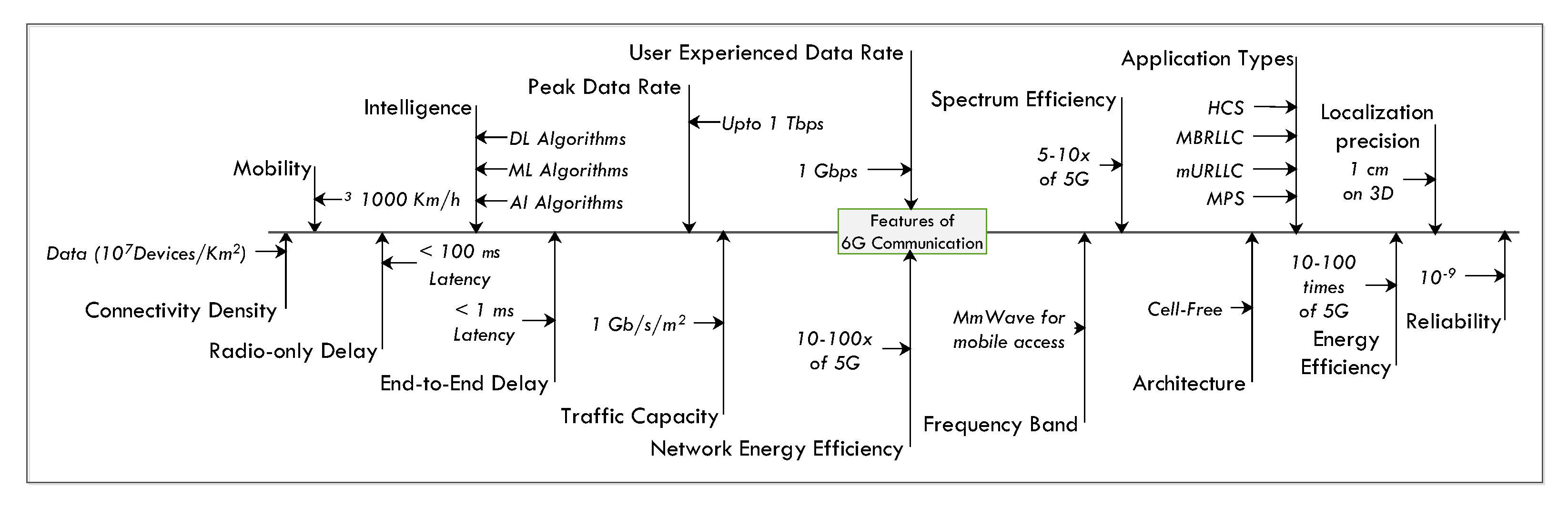
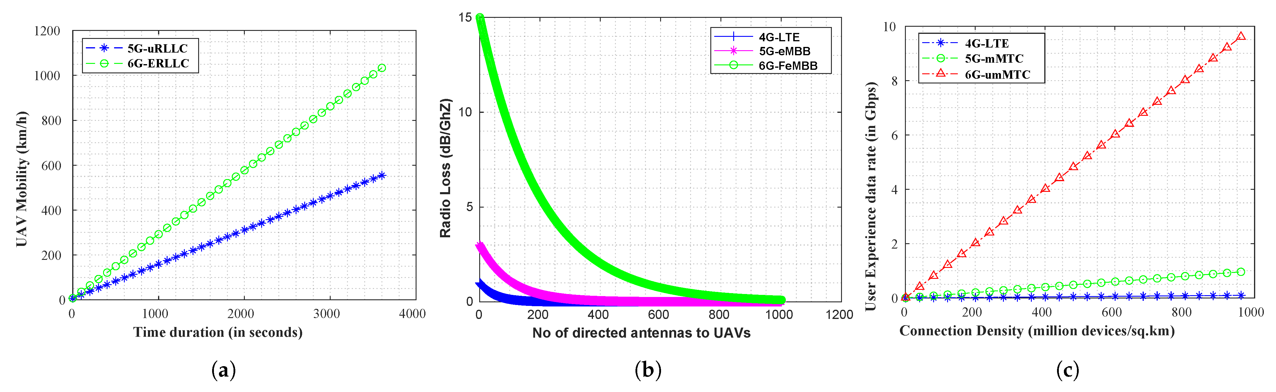
  • We highlight the open issues and research challenges in the integration of 6G-based UAV communication and present a use-case scenario that compares the presented 6G service set with 5G-based UAV service sets in terms of parameters such as communication latency, density, spectral efficiency, UAV mobility, radio loss, and user-experienced data rates. The presented results indicate the viability of 6G-assisted UAVs to tackle 3FFs at a massive scale.

1.2. Organization

The rest of the article is arranged as follows. Section 2 presents the details of the existing schemes to tackle the COVID-19 pandemic. Section 3 describes the UAV functionality to address the threefold functionalities for the fight against COVID-19 and future pandemics. Section 4 describes the proposed scheme that deploys the required functionality through UAV-based ecosystems. Section 5 discusses the task offloading scheme for UAVs, where data-intrinsic tasks are deputed to edge nodes, which learn through the federated learning process. Section 6 presents the detection of persons for thermal monitoring and surveillance in moving FoRs. Section 7 highlights the open issues and research challenges in the integration of UAVs and 6G through the proposed scheme. Section 8 validates the efficiency of the proposed scheme through performance simulations, and finally, Section 9 concludes the article.

2. Existing Schemes

In this section, we present the details of existing schemes to tackle the issues of the COVID-19 pandemic. Table 2 highlights the requirement of critical resources, UAV route setup, and the 6G network bandwidth of existing approaches with the proposed one. In 6G-UAV control, Xing et al. [21] proposed an optimization problem for COVID-19 medical kits, where the authors presented an optimal path trajectory to deliver the medical kits to the destinations with lower trip times. The scheme addressed the issues of UAV speed, trajectory, and ground-control parameters and proposed a low-complex hybrid reinforcement learning (RL) mechanism to fine-tune the communication parameters. In optimization, a heuristic approach is modeled to compute the optimal path between two geo-coordinate points, and Q-learning is employed to find the user sequencing (order) in which the kits are required to be delivered. The simulation compares the work against existing non-UAV delivery and North Carolina UAV delivery ecosystems. Owing to timely delivery completion cycles, the patients are treated for COVID-19 early, which helps patients to get cured and diagnosed early.
Goyal et al. [31] designed a real-time patent for an IoT-envisioned trash system, where trash collectors are equipped with pressure sensors, which measure the pressure on a trash collection system. The system communicates with UAVs, which monitor the garbage locations and transmit them through local transceivers. This type of real setup is highly essential as uncollected waste (dry and wet waste) can lead to contamination of water and land sources and becomes a breeding ground for lung and respiratory disorders. Thus, COVID-19 rates might shoot up, and the designed patent would indirectly benefit the implementation of 3FFs and avoid the unprecedented rise of COVID-19 positive cases, which would bottleneck the resource requirements to implement 3FFs. Rezaee et al. [22] present a crowdsensing scheme for densely populated regions, where the monitoring is supported through UAVs, and a water cycle algorithm (WCA) is exploited, which sends a short message service (SMS) to administrator nodes informing them of congestion. To strengthen the decision-making structure, the ResNet 50 model is used, which suggests alternate routes to the user in dense and blocked roads. A deep transfer learning (DTL) mechanism detects crowds and builds appropriate actions required to disperse the crowd. Experimental analysis shows an improvement in average accuracy, which is ≈96.55%, in challenging UAV flying scenarios. Suraci et al. [23] presented an applicative study on the 6G use cases to solve the diverse problem in different domains. Device-to-device communication with 6G and multi-access edge computing are presented to allow digital transformation. The analysis is carried out at the United Nations institute of advanced research training on 6G integration with future networks.
In UAV vaccine delivery, Verma et al. [19] presented a scheme, named SanJeeVni, that handles massive vaccine user registration at model centers via the Solana blockchain. As Solana has a high transaction rate of 65,000 transactions in 1 second (s), the addressing scheme is quite resilient and scalable. This assures that illegal vaccine hoarding is eliminated. A consortium setup is preferred, where vaccine details are shared with users and nodal centers. For latency in vaccine distribution, the scheme is presented against the backdrop of 6G communication that offers intelligent AI edge offloading, UAV movement, and ground station control. In parametric analysis, vaccination cost, 6G spectral efficiency, and energy consumption in traffic offloading are discussed, where an improvement of 86% is obtained in latency, as well as a 76.25% reduction in UAV energy consumption. Authors in [24] proposed a social distancing UAV scheme for COVID-19 over a pedestrian network where the foot movements and head positions are classified in real-time over the Peleenet backbone. On the Merge-head dataset, an average precision of 92.22% is obtained at a 76 frames per second capture. A You Look Only Once version 3 (YOLOv3) model with a single-shot detector (SSD) is utilized. However, UAV flights are challenged by limitations of high wind instability, which reduces the overall model accuracy.
Effective UAV designs for sanitization (disinfectant spray) are explored in [25], where a quadcopter UAV with a 2200 KV operating characteristic is designed over a proportional integral derivative (PID) controller to achieve superior torque control and high-altitude conditions. The quadcopter can carry 200 milliliters of disinfectant spray, which is insufficient for large regions. Janjua et al. [26] presented the role of 6G networks to handle rapid response units that can provide required resources to patients during disasters and epidemic control. The authors explored the UAV latency assessment and connection density assessment for a controller base station (BS) and presented key technologies of 6G to operate in hospital environments, remote sensing, and responsive disaster control units. However, the challenges of topology mobility (ad hoc wireless network formation) and ubiquitous coverage are considered major issues in the design of the responsive unit. Gupta et al. [27] presented the 6G vision for edge intelligence models. As 6G supports E2E latency of <1 ms and over-the-air latency of 100 μ s, it becomes a potential candidate for applications such as autonomous vehicles, UAV communication, and holographic communication supported through AR and VR. A reference use case of UAV-enabled 6G-assisted edge intelligence is discussed to fight the COVID-19 pandemic regarding social distancing and sanitization. Barnawi et al. [28] proposed a UAV-based delivery ecosystem for the COVID-19 pandemic for timely aid. Furthermore, a convolutional neural network (CNN) architecture is proposed inside the hospital setup for chest X-ray images. A deep transfer learning architecture is exploited and patients are classified into positive and negative classes. An accuracy of 94.42% is reported for X-ray classification. Based on the classification, timely medical deliveries are orchestrated through an optimal path-planning UAV swarm network. Authors in [29] presented radar-based UAVs for respiratory pattern detection of COVID-19 from remote UAV swarms. The radar senses the respiration rate and displacement associated with tachypnea. An adaptive filter method is applied with noise-cancellation features to improve the sensing accuracy. Siriwardhana et al. [30] discussed the potential use cases of 5G and Internet-of-Things (IoT) for COVID-19. The presented use cases include contact tracing, delivery supply chains, and real-time information sharing. The technical landscape and open challenges are discussed to leverage effective solutions to monitor COVID-19 patterns and present useful suggestions for daily tasks to the common public.
In COVID-19 detection models, Kaur et al. [32] proposed an image processing scheme for COVID-19 RT-PCR tests, named CD19-Net, which includes chest X-ray images. A deep learning (DL)-based model is designed on the Inceptionv4 architecture with a multi-class support vector machine (SVM) classifier, where the images are scaled and fed to the model. A detection accuracy of 96.24% is reported in the study on a 4-type classification and is further enhanced to 95.51% for three classes and 98.1% for two classes. The scheme is beneficial for places where there is a shortage of COVID-19 kits and demand is high. Authors in [33] proposed a machine-learning-based time series analysis to predict COVID-19 deaths using the NueralProphet model. The work employs exponential Gaussian distribution over a forecast period of 1 January 2020 to 16 July 2021 and predicts the impact on the death rate during the second wave of COVID-19. Loey et al. [34] proposes a convolutional neural network (CNN)-based X-ray classification, where a dual-layer pipeline is followed. In the first phase, the CNN model extracts useful chest features, which are fed to a Bayesian optimizer function to fine-tune the CNN hyper-parameters based on the selected objectives. the dataset is prepared with 10,848 images, with 3616 COVID-19 positive cases, and an equal amount of normal (negative) and pneumonia cases. Convergence charts are plotted scenario-wise, and the Bayesian optimizer function achieves 96% accuracy in the proposed work, which makes the model viable in real detection setups. Chew and Zhang [35] applied explainable AI (xAI)-driven predictive modeling to predict COVID-19 growth and its specific impact on death rates. A multi-scale analysis is presented spanning multiple countries and is designed with control factors classified into three clusters, which are fed to the Shapley Additive exPlanations (SHAP) xAI explainer module. A historical analysis presented the forecasting from 2 May 2020 to 1 October 2021, where control measures are identified. It is found to minimize the growth rate; social distancing and contact tracing are the most effective measures, where the average mean error falls below 10% in the modeling ecosystem.

Novelty

Recent variants of COVID-19 have put a burden on healthcare setups. Although mass vaccinations are in action, the new variants might pose a significant threat in the near future. Thus, it is required to avoid COVID-19 and follow the guidelines (social distancing [22], sanitization [25], and monitoring [16]) to curb the effective spread. Earlier approaches have addressed issues of COVID-19 surveillance, detection, UAV-based monitoring, and vaccine deliveries, but a unified direction that integrates 3FFs is not presented. The article addresses these research gaps and proposes a UAV-based scenario that performs 3FFs and improves the long queues in healthcare setups via responsive 6G communication. Through 6G, UAVs are assisted with multi-hop relays with different BS, which use massive antennas with AI-based interfaces to support energy-efficient relays. Furthermore, 6G assists UAV swarm communication at near-real-time latency, which assists in the inspection and monitoring of dense regions. Moreover, through AI-based object detection models, the social distancing condition is met. For mass sanitization, 6G-ERLLC allows mass sanitization of a designated coverage range.

3. The Proposed Scheme: Threefold Functionality

This section highlights the deployment of UAVs to tackle the spread of COVID-19 and future pandemics over 6G communication with responsive operations.

3.1. COVID-19 Pandemic: An Impact Analysis

The global virus spread has triggered economic repercussions on agriculture, tourism, and the manufacturing sector. As per the worldwide outlook reports, the overall world economy will shrink by 0.9% by 2020 in the worst case. Credit conditions in global financial markets will be tight, which will foresee businesses to downscale production and manufacturing units. With the sealing of international boundaries, worldwide tourism and export–import trade and food supply will be affected. The National Bureau of Economic Research predicts a decline of 17.2% in tourism and global trade, thereby affecting the jobs of 123 million people worldwide [36]. Thus, stringent and rapid measures must be employed in healthcare, supply chain, and manufacturing units to mitigate the spread of 2019-nCOV globally by the government and international organizations.

3.2. Threefold Functionalities

As depicted in Section 1, the key 3FFs help to reduce or overcome the effect of this health emergency pandemic. The WHO has also issued various guidelines regarding the implementation of these 3FFs. In-person implementation is slow as well as risky for people involved in it. So, UAVs are the best alternative to perform the 3FFs, as shown in Figure 2. Sanitization of disinfectants at the locations which are highly infected (red and orange zones) with COVID-19 is of utmost importance to reduce the effect of the pandemic. Agricultural drones can be used for sanitization. Another way to minimize the effect of the novel pandemic is social distancing, which aims to reduce in-person contact (i.e., between normal and infected persons) [8]. Social distancing can be monitored from the aerial view with the help of UAVs and generate an alarm in case people violate the specified norms (maintain 6 feet distances). The third functionality is the inspection of people’s body temperature and heart rate, which are the basic symptoms of coronavirus. Healthcare drones equipped with infrared cameras can be used for this purpose. So, different types of drones can perform 3FFs, reducing risk, saving cost, and with high precision. The detailed description of the functionalities and their controlling body are explained in Section 4. Before delving into the proposed scheme, we analyze some potential challenges to implementing the 3FFs in our proposed scheme. The challenges are aligned as follows.
  • UAV data management—In our 3FFs, we consider social distancing and thermal inspection of regions by UAVs. It would require high-end image processing algorithms, which could drain the useful battery of UAV swarms (grouped UAVs) by a considerable fraction. Thus, it becomes crucial to offload important tasks to nearby edge servers, which run federated learning (FL) for task learning. This would save essential battery consumption, and the UAV network lifetime would increase drastically.
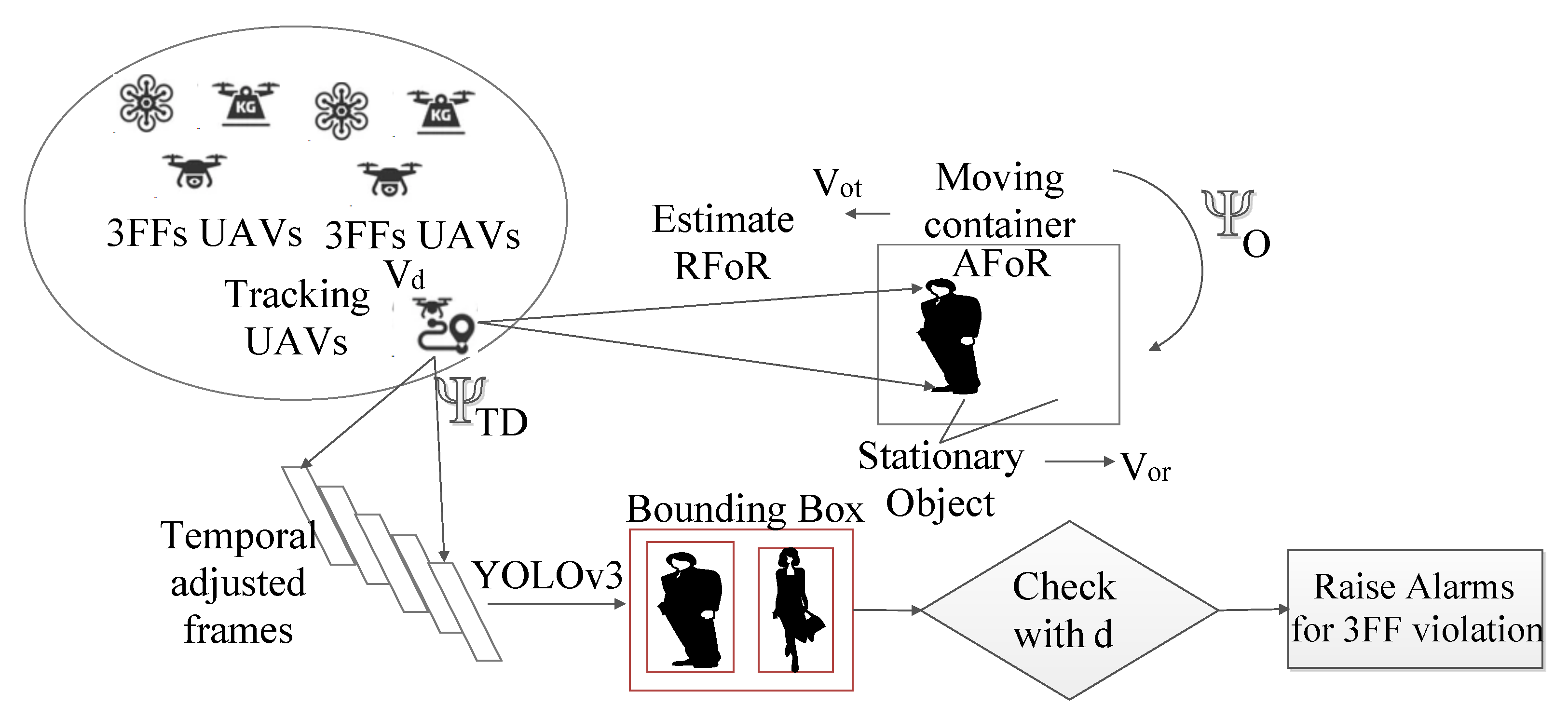
  • Non-stationary frames—To effectively realize the 3FFs, we assumed that persons (objects under consideration for thermal inspection, or social distancing) might be present in a moving frame-of-reference (FoR). For the persons, they are stationary, but for UAVs (outside the moving FoR), the motion is relative. Thus, the persons are moving, and we require a geo-fencing operation to locate the person in a moving FoR. In this case, we divide our FoR into coordinate frames (North, South, West, and East) and find the relative location of a person in the coordinate frame through a GPS tracker (which is installed in the personal application). We form a revised bounding-box estimation based on moving FoR to form the position estimate.
  • Blockchain for COVID-19 vaccine registration and supply management—Regarding the supply of COVID-19 vaccines after detection, the governance layer would raise the requirements of vaccine distribution to the nearest medical centers, which can deploy ground logistics (or UAVs) to carry the vaccines, maintaining the cold-chain process. The recent literature by authors in [6,37,38] indicates the use of blockchain for transparent monitoring and distribution of vaccines at the ground level.

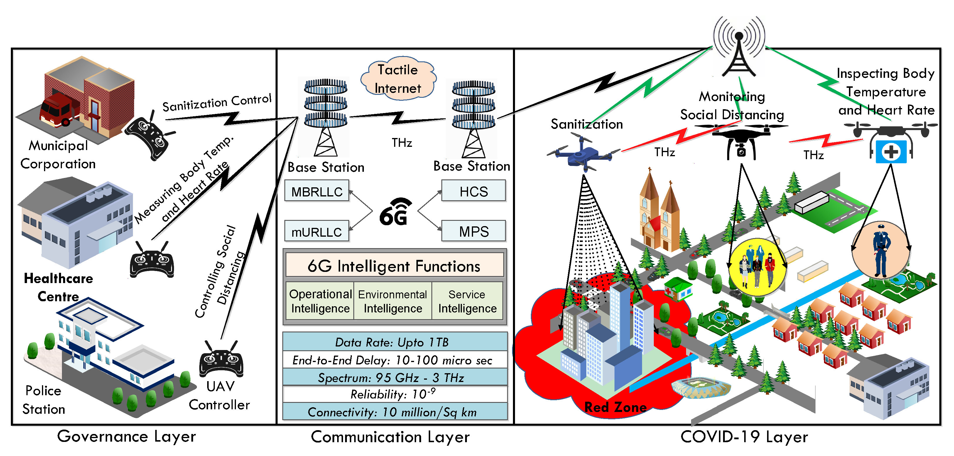
4. The Proposed Scheme: Architecture and Components

This section unfolds the functionality of the proposed scheme, i.e., a 6G-envisioned UAV scheme for social distancing, sanitizing, inspection, and monitoring of the COVID-19 pandemic. It is physically, as well as logically, divided into three connected layers: (i) governance, (ii) communication, and (iii) COVID-19 layers, as shown in Figure 3. The systematic elaboration of these layers is as follows.

4.1. The Governance Layer

This layer consists of various entities, such as the police station (PS), the municipal corporation (MC), and healthcare centers (HC), which are responsible for monitoring and controlling the COVID-19 pandemic effect in the country. We represent them as { E P S , E M C , E H C , E U A V } . At the governance layer, we consider that a given region R is demarcated into functional zones controlled by E M C . There are l hospital setups in any zone that provide critical COVID-19 resources (beds, ventilators, and medicines) [39]. Any zone is guarded for inspection via a UAV swarm network. Each entity ( { E P S , E M C , E H C , E U A V } ) has a UAV controller (acting as a ground control station) that controls the UAVs in the COVID-19 layer via a 6G-based UAV communication.
The data acquired by the COVID-19 layer from UAVs are forwarded to the 6G-based communication layer, where different intelligent functions (operational, environmental, service) are applied to the data to offer predictive services in the governance layer. We want to mention that the entire architecture uses salient features of the 6G communication to route their data from one layer to other. Once the governance layer acquires the intelligent data, different governance bodies can take specific actions, such as providing physical assistance to COVID patients, emergent assistance to the red zones, and sending more sanitization and medical supplies. Furthermore, there is no central node that manages the entire architecture; only in the governance layer, each governance body has a ground control station that is used for controlling different UAVs working in the COVID-19 layer. However, they are decentralized because all the governance bodies depend on each other and continually exchange data. For instance, the healthcare center UAV controller controls the UAV measuring body temperature; when it acquires the data from the UAV (measure temperature), it will store the data in the repository, which is shared with other governance bodies, such as police stations and municipal corporations, to take necessary action in the COVID-19 layer.

4.2. The Communication Layer

This layer is responsible for establishing the communication between the UAVs at the COVID-19 layer and the ground control stations at the governance layer. The following communication architecture employs 6G services that provide a vast spectrum and are well-suited for delay-sensitive applications. Various characteristics of 6G communication are as shown in Figure 4. The user-experienced data rate in 6G is ≈1 Gbps, which is almost ten times faster than 5G. The energy and spectrum efficiencies of 6G are 10–100 times and 5–10 times those of 5G, respectively [14]. Moreover, 6G allows the virtualization and slicing of networks through software-defined networking (SDN) and network function virtualization (NFV) of the physical and medium access control (MAC) sub-layer. To achieve the same, ML/DL techniques are employed to train the network for resource intelligence and form informed decisions on the trained network models. Thus, virtualization in 6G will prove to be the key enabler of a highly digitized society, where everything is autonomous and connected.
Letaief et al. [40] suggested that the 6G communication network needs the support of new services beyond the 5G network as computation-oriented communications, contextually agile eMBB communications, and event-defined uRLLC. In similar directions, the 6G layer of the proposed scheme provides key services for various intelligent network orchestration for wired and wireless communication services. These services include (i) operational intelligence that allocates the network resources (such as spectrum and power) proficiently to optimize the highly complex network operations, (ii) environmental intelligence that helps to realize diverse application scenarios such as UAVs, autonomous vehicles, and auto-robots, and (iii) service intelligence techniques such as ML/DL that assist many human-centric applications (i.e., e-healthcare, information searching, and learning and educational systems) intelligently to raise user satisfaction [41].
6G networks in UAV communication play a vital role in controlling the UAVs efficiently and effectively. They also allow multiple UAVs to operate in a region because of their wide spectrum and high device connectivity density. The AI characteristic of 6G makes the proposed system precise, intelligent, and autonomous by monitoring real-time network performance parameters to maintain users’ desired quality of experience (QoE) [42].

4.3. The COVID-19 Layer

In the COVID-19 layer, the geo-locations of COVID-19-affected areas can be tagged. In such locations, the role of governing bodies is to control the COVID-19 pandemic effect through specialized UAVs, i.e., different UAVs for monitoring, inspection, and social distancing. All UAVs can communicate with each other wirelessly to exchange data about geo-location coordinates, personal details, and contact histories. Each UAV consist of a wireless control unit that uses radio frequency to communicate with each other (e.g., sharing critical data). Formally, it operates with a wireless fidelity (Wi-Fi) protocol with a radio frequency ranging from 2.4 GHz to 5 GHz for data exchange, but as we are using 6G-enabled UAVs, they utilize higher operating frequencies (i.e., 102.1 GHz), providing a much more stable frequency range for data exchange. Due to 6G-based communication, UAVs can quickly share data with higher data rates and reduced latency, thus improving the performance of the entire system. Then, the monitoring UAV informs the sanitization UAV via the GS about the affected region where the sanitization is required. UAVs generally target regions labeled as red and orange zone (highly affected areas).
The aim of social distancing UAVs (centrally controlled by the police department) is to ensure that people maintain the required distance from those affected by the virus. It is equipped with either thermal or infrared and color image cameras. It first traces the human bodies and then calculates the distance between them. Distance could be either Euclidean distance or Manhattan distance, where X and Y are the location coordinates of two persons. If the distance is less than the threshold value D t h , then an automatic announcement “maintain social distancing” can be made through the UAV.
The aim of sanitizing UAVs is to disinfect the COVID-19 high-affected areas at regular intervals to mitigate its effects and further spread. Sanitizing UAVs identifies the spot precisely through improved 6G communication, which has high-bandwidth channels. It can form high-capacity mmWave communication with GS for improved transmission. Moreover, spot location pictures can be transmitted at ultra-high-definition (UHD) and 4K resolution cameras supporting augmented and virtual reality. Thus, UAVs identify the spot correctly and accurately with less wastage of disinfectant. The function of a monitoring and inspection drone (healthcare drone) is to trace the humans first, then measure their body temperature and heart rate (the basic symptoms of coronavirus). If anybody is found suspicious, then the traced information can be forwarded to the concerned authority. Based on that information, a person can be quarantined for a stipulated period. The details of 3FFs are presented as follows.

4.3.1. COVID-19 Social Distancing Monitoring

E P S monitors whether the persons (citizens), represented as P c , are following the social distancing norms or violating them. To assist them, we consider that k  E U A V forms a swarm network, represented as { U 1 , U 2 , , U k } . The UAV operations are controlled by E P S , where a single UAV might be administered by more than one E P S . We consider that in any given region R, there are v  P c who have aggregated, with the trivial condition v > 1 . E U A V records their movements by capturing video sequences (frames) and applies fast detection AI algorithms such as Faster region-based convolutional neural network (F-RCNN), single-shot detector (SSD), and YOLOv3 algorithms [43]. We consider two persons P c 1 and P c 2 located at d distance apart. The role of the E U A V is to monitor whether people are following the guidelines (social distancing) regarding the COVID-19 outbreak (public health emergency) issued by the World Health Organization (WHO) [8]. As per the WHO regulations, a distance of ≈2 m should be followed, which is represented as follows.
D ( P c 1 , P c 2 ) 2 m
Social distancing is a key measure that restricts the outspread of COVID-19 [8]. In algorithms such as F-RCNN and YOLO, there is a bounding box B with coordinates ( w , y , a , b ) , where w and y represent the top-left coordinates, and a and b are the width and height of the box. A ground truth T g is considered for distance prediction. The distance D ( P c 1 , P c 2 ) is computed on the Euclidean metric, which considers the B coordinates as follows.
D ( P c 1 , P c 2 ) = ( X j X i ) 2 + ( Y j Y i ) 2
where ( X i , Y i ) and ( X j , Y j ) are the centroid measure of bounding boxes B 1 and B 2 , which correspond to users c 1 and c 2 . In the case where the distance D ( B 1 , B 2 ) is ≤ 2 m, an alarm is raised and E M C is notified of the condition. In such cases, E H C registers the users for COVID-19 checkups at the nearest centers, and if the persons are found COVID-19 positive, registers them to the positive database and follows the quarantine rules.
Algorithm 1 presents the schematics of the social distancing algorithm. We consider that k UAVs capture the real-time video feeds { f 1 , f 2 , , f k } and number the frame sequences S e q f into frame buffer F. Lines 1-4 present the conditions. Once frames are numbered, we consider that for each captured frame, we form the bounding box through algorithms YOLOv3 or SSD and capture the box B coordinates. Next, we consider that for all person pairs ( P c q , P c l ) captured through B, the coordinates are noted and denoted as M q and M q . If B coordinates are the same, it signifies two cases—(1) two persons are standing nearby, or (2) the algorithm has captured only one person’s location. We iterate the frame sequences, and if the sequences are the same, then we continue to the next frame, else, we compute the euclidean distance D. Lines 5–13 present these conditions. Next, if D < 2 m, then it is considered a social distancing violation, and the information is sent to E M C for proper action. We also flag the critical flag as 1 to indicate the event. Lines 14–22 present the condition.
Algorithm 1 Social Distancing
Input: Registration information R ( P c ) , UAV swarm network { U 1 , U 2 , , U k } .
Output: Critical 3FF Boolean flags { f 1 , f 2 , f 3 } , where f 1 is the flag for social distancing violation and f 2 is for sanitization.
1:
procedureSocial_Distancing( P c , U k , E P S , E H C )
2:
  for ( i 1 to k) do
3:
     U i Capture_Video( f 1 , f 2 , , f k }
4:
     F Load_frames ( S e q f )
5:
    for ( j 1 to q) do
6:
       M j Bounding_Box ( F j )
7:
      Form coordinates for M j
8:
      if ( P c 1 P c 2 ) then
9:
        Compute two bounding boxes value M j and M j
10:
        if ( M j = = M j ) then
11:
          Sequences are the same
12:
        else
13:
           D Euclidean_Distance ( M j , M j )
14:
          if ( D 2 m) then
15:
             f 1 1
16:
            Send Social distance violation to E M C
17:
          end if
18:
        end if
19:
      end if
20:
    end for
21:
  end for
22:
end procedure

4.3.2. COVID-19 Sanitization

To ensure sanitization, we consider that E M C demarcates a given region R into demarcations (red and orange zones), which are represented as Z r and Z o , respectively. For sanitization purposes, a UAV swarm network is set up specifically that considers hexacopter drones, which are capable of vertical take-offs and landings. In such drones, a brushless direct current (DC) motor is present, and they are coupled with high-propulsion and thrust controllers. After analyzing the literature [44,45,46,47], we observed that the hexacopters and octocopter drones are feasible for spraying purposes; the same drones are also used in the agriculture fields for insecticides and pesticides spraying. For example, the SYENA-H10 hexacopter is equipped with 5, 10, and 15 L of payload capacity that can cover 60, 30, and 10 acres of COVID-19 zones as per the volume spraying, i.e., ultra-low, low, and medium volume spraying, respectively [44]. A detailed comparison of different hexacopters with their technical specifications is illustrated in Table 3.
A spray setup S p is added as a payload to the drone. A ground controller station ( E M C ) of that region sets up a swarm controller S c to lead the swarm network for flying path and altitude setup. We consider that for a given region R, we demarcate the region into specific zones Z r and Z o , depending on the number of COVID-19 positive cases. In R, we assume a group of swarm UAV networks { N 1 , N 2 , , N s } . In any network N s , we consider the coverage area C a r e a of k t h E U A V . Based on captured feeds (distance violations), and COVID-19 central database counts, the drones form a long-term forecasting estimation of rising COVID-19 positive cases [48]. A specified threshold δ for the number of distance violations triggers the UAVs to send a signal to their nearest station, which refers to the number of cases registered in the past 7-day window [39]. E H A in that region cumulatively sends the bed and ventilator availability, and with high bottlenecks, the regions are flagged into Z r and Z o [49]. In these regions, the hexacopter drones perform sanitization on a regular basis to reduce the transmission rate of the virus.
Algorithm 2 presents the UAV sanitization algorithm into demarcated regions based on COVID-19 cases. We consider a UAV swarm network, where the hexacopter drones are loaded with spray setups. We divide the entire region R into n sub-zones and assign k UAV swarms to monitor these zones. In this case, k > n , as some zones might have more than one swarm network, based on the coverage range of the swarm network. In any area, C a r e a , video feeds are captured, and social distancing is monitored as presented in Algorithm 1. If the social distancing between two persons is less than a specified threshold δ , we notify E H C to send the resource availability (beds and ventilators) in a given region. Lines 1–9 present these conditions. If sufficient resources are present at health centers, we demarcate the zone as Z o , indicating a potential low COVID-19 hotspot. We monitor the contact chain of the person and flag all close contacts as potential COVID-19-positive cases. We initiate the swarm network to set up flight parameters and reach the Z o region for sanitization. Lines 10-13 present these conditions. In case sufficient resources are not available at E H C , the hospital setups in the near future would face resource shortage, and hence E N C flags the zone as Z r (serious COVID-19 hotspot), where strict isolation and monitoring is followed by E N C . Lines 14–17 present this scenario.
Algorithm 2 Sanitization
Input: UAV swarm network { U 1 , U 2 , , U k } .
Output: Critical Boolean flag f 2 for sanitization in a designated region R.
1:
procedureSanitization_UAV( E M C , { U 1 , U 2 , , U k } )
2:
  for each region R do
3:
    for  i 1 to n do
4:
      for  j 1 to k do
5:
         N i  UAV_Initiate  R i
6:
        Compute C a r e a for each R i
7:
         U j i  Capture_Video ( C i )
8:
        if  ( D ( P c 1 , P c 2 δ )  then
9:
          Notify E H C to provide resource availability
10:
          if  R ( A ) is sufficient then
11:
            Demarcate R into Z o
12:
             f 2 1
13:
            Initiate U j for sanitization
14:
          else
15:
            Demarcate R into Z r
16:
             f 2 1
17:
            Initiate U j for sanitization
18:
          end if
19:
        end if
20:
      end for
21:
    end for
22:
  end for
23:
end procedure

4.3.3. COVID-19 Thermal Inspection

For thermal inspection, we consider E U A V to be equipped with two sets of cameras, one is the normal camera, and the second is the thermal imaging camera, which is connected to ground networks through a 6G communication channel. Each UAV has a unique distance measurement standard; for instance, the UAV with the MEDICAS thermal imaging system can capture the thermal image at a distance of 5 m with an area of 4.1 × 3.3  m and a spot size of 6.5  mm/2 cm. Furthermore, with a distance of 20 m, it can capture an image area size of 16.8 × 13.6  m with a spot size 2.6  cm/7.8 cm. Here, the MEDICAS system offers an image resolution of 640 × 512 pixels, which works well for any computer vision algorithm to process thermal images [50]. Similarly, other UAVs have their specifications to capture thermal images, but formally, all imaging systems use spot size ratio (SSR) to determine how far you can measure.
SSR = distance spot size
For example, a thermal imaging system with an SSR of 39:2 implies that the imaging system could measure an object of 2 feet at 39 feet away.
The thermal imaging cameras mounted on any k t h UAV measure the skin temperature (in a contactless manner) of any person. The normal body temperature is ≈98.6 F. Thus, any temperature higher than this value is flagged as a potential case. However, the temperature measurement consideration has the inherent limitation of fixation on a particular region, and we consider the face as our region of interest (RoI). Thus, in the first part, we consider video frame sequences, denoted by { V 1 , V 2 , , V l } , which are collected and labeled with tags (frame number), denoted by { F 1 , F 2 , , F l } . For human face detection, a histogram of the oriented gradient (HOG) encoding is used to form reduced labeled versions of the images [51]. Next, we consider an identification algorithm embedded with thermal cameras mounted on UAVs. We consider a user registration portal where users in the region R are registered with E N C . The registration of any user P c at E N C is depicted as follows.
R ( P c ) = { I D ( E M C ) , P n a m e , P h a , P i 1 , P i 2 , , P i t }
where I D ( E M C ) is the identity of the registering MC, P n a m e is the person name, P h a is the home (residential) address, and { P i 1 , P i 2 , , P i t } are t pictures of P c captured from different orientations (normally t [ 1 , 5 ] ) to train the machine learning algorithm. We apply HOG to form image labels and send the face embeddings 128 × 1 to be trained via computer vision algorithms such as YOLOv3 and F-RCNN. The UAVs capture the normal and thermal images in real time and send the videos at a specified frame rate over the channel [52]. In case the forehead region in the thermal image (captured in real time) has a higher temperature, then the personal details are fetched from R ( P c ) , and E M C visits the person and performs COVID-19 detection tests (RT-PCR, blood tests, and others).
Algorithm 3 presents the thermal inspection algorithm. In this algorithm, every U A V k is assisted by two cameras, one normal camera and one thermal camera. In any given region R, real-time video feeds are captured by both cameras, and frames are depicted as F n o r m and F t h e r m , which are stored in database D. Lines 1–6 present these conditions. Now, we label the RoI in the stored images (forehead) and capture essential attributes on both F n o r m and F t h e r m . The HOG algorithm is utilized for this purpose. Lines 7–12 present these conditions. On the HOG images, we execute our models M n and M t with the YOLOv3 algorithm (per-frame basis) and note the temperature values. Now, the difference between normal temperature and increased temperature is noted. Lines 13–14 present the same. Moreover, persons residing in any region R have to register themselves to E M C , such that E M C can track the persons in case the temperature is higher than normal temperature. If the temperature is higher, we identify the home address of person P c , and E M C is notified of a potential COVID-19 case. A flag value f 3 of 1 indicates a high probability of a positive case, otherwise, the person is marked as normal. Lines 15–24 present these conditions.
Algorithm 3 Thermal inspection and monitoring
Input: UAV swarms assisted with normal and thermal cameras. Output: Critical Boolean flag f 3 for thermal screening of P c in a designated region R.
1:
procedureUAV_Thermal_Inspection( U A V k , R )
2:
  for each region R do
3:
    for  i 1 to k do
4:
       U A V i Video_Frames_Normal ( P c , R )
5:
       U A V i Video_Frames_Thermal ( P c , R )
6:
      Store F n o r m , F t h e r m into database D
7:
      for Each F n o r m image do
8:
         R O I n o r m HOG( F n o r m )
9:
      end for
10:
      for Each F t h e r m image do
11:
         R O I t h e r m HOG( F t h e r m )
12:
      end for
13:
       M n YOLOv3( F i , R O I n o r m )
14:
       M t YOLOv3( F i , R O I t h e r m )
15:
      Register P c to E M C
16:
      for Each registered person P c  do
17:
        Monitor T e m p ( P c ) from M t
18:
        if  T e m p ( P C ) > 98 . 6 F  then
19:
          Identify P c from M n
20:
          Notify E N C of potential COVID-19 case
21:
           R 3 1
22:
        else
23:
           R 3 0
24:
        end if
25:
      end for
26:
    end for
27:
  end for
28:
end procedure

5. Federated Task Offloading in the Proposed Scheme

The section discusses the data-intrinsic capabilities of the proposed scheme. Figure 5 presents the details.
In this scheme, we consider that there are demarcated zones at E M C that would functionally provide the availability of COVID-19 resources (beds, ventilators, and vaccines), which are provided by E H C . Based on this, at the communication layer, k  E U A V forms a swarm network, which is denoted as { U 1 , U 2 , , U k } . The swarm network is controlled through U A V c , designated as the controller node. The data captured by k UAVs in the network is shared to the U A V c , which offloads the same to nearby edge servers as tasks. In general, we assume that p tasks { T 1 , T 2 , , T p } need to be offloaded to local proximity edge server E s e r in a zone Z. A task-tuple between any k t h UAV controller to q t h E s e r is presented as follows.
F t = { b k , q , c k , q , Δ k , q }
where b k , q denotes the size of federated task F t offloaded from k t h UAV swarm controller to the q t h edge node, c k , q , respectively, denotes the CPU cycle requirements by q t h E s e r , and Δ k , q presents the task deadline information.
However, please note that not all tasks are offloaded to E s e r . A decision variable D ( s ) denotes which tasks can be solved at E U A V , which at U A V c , and only a subset t is offloaded to E s e r . For example, the decision variable operates as follows.
D ( s ) = 1 b k M U k   & &   c k < c ( U k ) 0 b k M ( U A V )   & &   c k < c ( U A V ) 1 b k > M ( U A V )   & &   c k < c ( U A V )
where b k denotes task size, which needs to be smaller than the available memory of U k (local swarm drone), and CPU cycles in the range of U k . Similarly, the tasks might be operated at the controller node or the edge server node.
E s e r might also require high-end processing, and thus is connected to the global cloud server (GAS) for execution. As per Shannon channel capacity, the maximum uploading time for E U A V to delegate its task to E s e r is given as follows.
T ( F t o ) = B c l o g 2 ( 1 + q k g k 2 ω k B c )
where T ( F t o ) denotes the uploading time of federated task F t o , B c represents the channel bandwidth for the U A V c - E s e r link, q k denotes the transmission power of U A V k , ω k denotes the power density function, and g k 2 is the channel gain. A task T might be split for local execution (swarm network or controller) or might be remotely executed at E s e r . In the case of local executions D ( s ) = { 1 , 0 } , the energy consumption and execution time are computed as follows.
T t U k = b k / c ( U k ) T t U A V c = b k / c ( U A V c )
E t U k = Ξ m , n b k E t U A V c = Ξ m , n b k
where T t U k , T t U A V c , respectively, denote the execution time of U k and U A V c , and E t U k and E t U A V c denote the energy consumption for task execution. X i m , n denotes the coefficient of energy consumption by the m t h UAV controller when it connects with the n t h   U n .
In case of remote execution by E s e r , where D ( s ) = 1 , we add the link delay with T E s e r and subtract the energy dissipation of the link. Mathematically, it is presented as follows.
T E s e r = T l + T E s e r E E s e r = E E s e r E ( l )
We consider the remote case, where FL learning is applied for route planning, parameter optimization, and optimization of network parameters. We consider that U A V c sends an offloading request F t o req to E s e r . b k is the data size on which E s e r forms output prediction y i for data point x i . In such cases, every E s e r in local zone Z computes a local model L m . To present the same, consider that h zones are demarcated, and each zone has a local E s e r which operates on b k . The edge server nodes act as clients and download the global model from the cloud server, denoted as E c s . The global model G m has the following initial conditions.
G m = { w 0 , N ( R ) , G b k , G η , L f g }
where w 0 denotes the initial weight of model, N ( R ) denotes the number of iterations for training, G b k denotes the global batch size, G η is the global learning rate, and L f g is the global loss function.
Based on downloaded G m , any h t h local E s e r forms the local models L m with the following parameters.
L m h = { w 0 h , N ( L ) , L b k , L η , L l g }
where L b k denotes the local batch size, L ( R ) is the local iterations, L η is the local learning rate, and L l g is the local loss function. The aim is to minimize L l g with successive iterations. At local nodes, each edge server (client) splits L b k into small batches denoted by β and runs local epochs from 1 to q. For every batch β L b k , the weight function is updated as follows.
w c = w p L η D L m
where D L m denotes the local gradient. These h client nodes return w c to E c s , which updates its weight function for the next iteration as follows.
w k + 1 h = k = 1 h w c
The global loss function is denoted as f ( w ) = n h n F h ( w ) , where F h ( w ) = 1 n h i p h f i ( w ) .

6. Non-Stationary Object FoR Estimation

In this section, we discuss the schematics of non-stationary person identification by 3FFs UAVs. We consider that UAV swarms { U 1 , U 2 , , U k } are visually tracking objects such as boats, trains, and flying objects in which our object of interests (persons) are located. Thus, these persons fall under the non-stationary detection category. Figure 6 presents the scenario. In this, we consider that in the swarm network, we have a tracking UAVs, which track the geo-fencing location of the person (inside the object), also denoted as containers in our scheme. For geo-fencing, each person needs to keep the GPS sensor in ON mode, from where the ( l a t , l o n g ) coordinates are located by satellite S. S communicates with the mobile apps, which send the signals to the a UAVs. However, for accurate prediction of a person, multiple satellite nodes coordinate through the trilateration process, which reduces the biases in the distance computation of objects with the UAVs.
In our case, we consider that moving containers have a velocity (with a relative direction towards the tracking UAV, or moving away from UAV). We denote the towards velocity as V o t and receding object velocity as V o r . Moreover, the object might have a rotational kinetic component, denoted by ψ 0 . We divide the estimation into FoR, where two types of FoRs are present—actual FoR (AFoR) and relative FoR (RFoR). In the AFoRs, the person is stationary, but in the RFoRs, the person is moving with the linear and angular velocity of the container. Thus, we base our approach on the dual-model background subtraction method [53], where moving estimations are captured by UAV sensor cameras, and thus accurate location in the container is presented. Based on the AFoR, motion compensation is measured from the baseline (when AFoR and RFoR are the same). A sampling map S m a p is formed, and the next map depends on the relative shift Ω obtained from the previous map M i 1 to current M a p i . A foreground probability map is formed by the YOLOv3 model, where the pixels ( x i , y i ) in container FoR (map) are adjusted (subtracted) with the object displacement in a unit time t. Thus, we compute the distance d that the containers move in a unit of time ( v . t ) and subtract the same from the temporal map sequence to obtain the stationary FoR. In terms of angular movements, the container can move in any of the X, Y, and Z axes, and thus the projective distance p d is computed per unit of time to adjust the temporal map sequence. In terms of pixels, the temporal sequences T M are denoted as follows.
T M = ( 1 α T ) T M i 1 ( p ) + α T D i ( p )
where i is the frame indexes captured by UAVs, and α T is the temporal learning rate of the model. p denotes the pixel values of bounding box estimation for the person and T M i 1 denotes the temporal map matrix at the previous frame ( i 1 ) . The next frame is corrected based on velocity estimation (both linear and angular). To match the spatial pixel property, we compute the coherency of spatial pixels as follows.
S M t ( p ) = ( 1 α s S M t 1 ( p ) + α s 1 n 2 i N ( p ) D t ( p )
where N ( p ) denotes the neighboring map at spatial instance ( t 1 ) . The foreground probability is denoted as follows.
P F G t ( p ) = T M t ( p ) . S M t ( p )
where (.) denotes the convolutional operation. For bounding-box estimation by the model, the RFoR is constructed as a grid sequence ( q × q ) grid, where we fit the temporally adjusted frames in the grid for box estimation B e . We consider a total of p grids, denoted as { G 1 , G 2 , , G p } constructed for the purpose. The mean μ t ( G ) and standard deviation σ t ( G ) are formed from the previous model estimate M ( t 1 ) , which is denoted as follows.
μ t ( G ) = ( 1 α t 1 M ( t 1 ) μ t 1 M ( t 1 ) + α t 1 m t M ( t ) σ t ( G ) = ( 1 α t 1 M ( t 1 ) σ t 1 M ( t 1 ) + α t 1 ν t M ( t )
where m ( t ) denotes the average mean of all previous ( 0 , 1 , 2 , , M ( t 1 ) models, and ν ( t ) denotes the statistical variance of previous models. Once the bounding box is accurately estimated, we check the threshold values (distance computation in case of social distance and temperature in case of thermal inspection), which are denoted as d. If the obtained values are higher than d, it indicates a 3FFs violation, and alarms are raised by the UAV swarm network.

Vaccine Forecasting and Blockchain-Based Vaccine Distribution

E M C based on the real-time data obtained by 3FFs UAVs would form an estimated model for the prediction of COVID-19 patients in the future. Based on the estimate, E M C would be notified about the requirement of vaccine supplies. Authors in [39] have proposed a scheme, ABV-CoViD, which forms a hybrid time series estimation of the availability of COVID-19 resources (based on occupied beds and ventilators at E H C ). The prediction model allows an effective supply of vaccines and other resources to nearby hospitals by E M C . Similarly, in vaccine distribution by UAVs, authors in [19] proposed a vaccine distribution scheme, named SanJeeVni, where the authors proposed registration of users based on priority (front-line workers, hospital staff, senior citizens, and others) for vaccination. The users have to register themselves to the Solana blockchain network, owing to its high rate of adding transactions (≈65 K TPS and efficient consensus protocol Proof-of-History. The entire distribution logic from the vaccine warehouse to municipal centers is carried by UAVs at the backdrop of 6G-ERLLC communication links.

7. Open Issues and Research Challenges

In this section, we highlight a few of the key open issues and research challenges for future perspectives. The description of such objectives is as follows.

7.1. Device Complexity

6G is an intelligent network equipped with AI algorithms to enhance its performance, i.e., quality of service (QoS). For different users, differential QoS will be mapped to network units intelligently to map services with QoE. To manage the same, highly complex network virtualization needs to be deployed at core switches and routers. This increases the operational cost and leads to a higher device and network maintenance cost. It is an open challenge to make devices and network costs affordable to 6G users.

7.2. Health Hazards

6G offers an exceptionally high data rate (in terabytes) for high-speed communication networks over the THz frequency band, which is hazardous for human eyes and skin tissues. Human safety from THz waves is a challenging task in the 6G environment. To address the same, super-narrow beams need to be deployed that minimize the propagation loss of fading channels and the interference of inter-symbols in data patterns, which is a challenging task.

7.3. Environmental Conditions

The current environmental conditions in which the UAVs operate pose a challenge, as they may change the predetermined path to the destination, which results in mission failures.

7.4. Energy Management

UAVs are lightweight, battery-operated flying devices with a limited lifetime. The devices and infrastructure of 6G generate a large amount of data after regular intervals. So, processing such big complex data in a multi-UAV environment requires high computation power, which can drain the UAV battery and interrupt the whole operation.

7.5. Blockchain-Based Spectrum Sharing

6G can operate in a 3.5 GHz unlicensed spectrum band, allowing different users to share the band for application requirements. However, band access can be monopolized by centralized auction-based strategies that favor a particular group of users for larger quantum-of-band access for higher bandwidth. This drastically affects the bandwidth requirement of other honest users. Thus, 6G leverages blockchain-based spectrum sharing for smart access to band services with equal quantum to all users to maintain trust in operations. Addressing blockchain integration with 6G is an active area of research.

7.6. Security

UAVs operate over an open wireless channel, which any malicious node may attack. A malicious user can either change the UAV path or hijack the whole UAV. So, the security of UAVs is of utmost importance in such a critical COVID-19 outbreak.

7.7. Privacy

Maintaining the privacy of user data is also of utmost importance. It can be achieved using cryptographic algorithms using digital signatures, SHA-256, and message digest algorithms. All these algorithms require high computation power to encode and decode the information.

8. Performance Evaluation

In this section, the performance evaluation of the proposed scheme is discussed based on the benefits of deployment of 6G services at the communication layer to improve 3FFs against traditional 5G services and 6G network characteristics to leverage efficient UAV communication.

8.1. Improved 3FFs of 6G-Enabled UAVs

As depicted in Figure 4, 6G offers a bandwidth of 1 Tbps, with a peak rate of back-haul and front-haul connections close to 10 Tbps [54]. Thus, 6G-assisted UAVs can be deployed in critically infected zones to assist 3FFs over defined spatial coverage area, as depicted in Figure 7, to tackle the COVID-19 pandemic. Traffic capacity of 6G-FeMBB is ≈0.7 Gb/s/m2 and 6G-umMTC is ≈1 Gb/s/m2, compared with 5G-eMBB and 5G-mMTC, with traffic capacities of 0.05 Gb/s/m2 and 0.1 Gb/s/m2, respectively. The following is shown in Figure 7a. Thus, 6G-based UAVs can handle massive data requests generated per m2, which improves the monitoring performance of inspection drones. Figure 7b shows the improved latency of 6G-umMTC over conventional 5G-mMTC and 4G-LTE-A services. Thus, real-time responsive actions can be performed by UAVs with GS in their spatial range. Figure 7c demonstrates the spectral efficiency coefficient η as η = P D / ρ × A , where P D is total data traffic by communicating antenna, ρ is the channel bandwidth, and A denotes the coverage area. As the η of 6G services is ≈5–10 times of 5G-URLLC, the spectral efficiency of fading antennas is high. Thus, 6G-enabled UAVs have a higher lifetime and can disseminate information at far-located GS over 5G counterparts.

8.2. 6G-Assisted UAVs Network Characteristics

6G offers improved network QoS and reliability over 5G services. The proposed UAV and 6G-based architecture are implemented by impersonating the behavior of a 5G network in the 5G toolbox of the MATLAB tool. Here, a different simulation parameter of the 5G network is configured to simulate a 6G waveform. For that, we first referred to the diverse literature to acquire 6G simulation parameters and based on those parameters, we configured the 5G toolbox to simulate a 6G network [55,56,57]. Parameters such as frequency range, channel bandwidth, network impairments, modulation, channel coding, and sub-carrier spacing are modified in the 5G toolbox to achieve the indispensable characteristics of the 6G network. Table 4 shows the simulation parameters used to simulate the 6G network for the proposed architecture.
Figure 8a shows the improved UAV mobility of 6G-ERLLC, which is ≈1000 km/h in the best case, over the 5G mobility of 550 km/h. Figure 8b shows the radio loss of 6G-based antennas that communicate with UAVs inside a spatial range. As 6G spectrum efficiency is ≈5–10 times better than 5G channels, and the path loss is minimized, resulting in an improved lifetime of UAV communications. The user-experienced (UE) data rate of 6G channels is 1 Gbps, compared with 100 Mbps in 5G, and 10 Mbps in 4G, as shown in Figure 8c. Moreover, a connection density of 6G is ≈10 7 devices/km2, which is ten times that of 5G. Thus, as more devices are added to 6G ecosystems, the UE data rates do not drop drastically, resulting in a better experience for 6G users. This is useful for UAVs, as they have to send ultra-HD high-resolution images of infected COVID-19 hotspots to GS.

8.3. Computational Offloading and FL Characteristics

In this subsection, we discuss the impact of U A V c controller node offloading the data to E s e r . We present the simulation parameters and system setup for the UAV and the FL setup. The details are presented as follows.

8.3.1. Simulation Setup

For the UAV setup, we formed a UAV swarm network, where 5 UAVs are kept as part of each swarm network. An edge server node is set up to communicate with the UAV controller, which is equipped with an Intel Core i7 processor, operating at 2.6 GHz and 32 GB RAM capacity running Ubuntu 21.04 LTS. Table 5 presents the simulation parameters for the UAV and FL setup. The task size b k is varied as [0,200] MB. The flying altitude is set to 40m, and data input follows the uniform distribution expressed as follows.
F ( x ) = 1 / ( q p ) q x p 0 otherwise
For the FL learning setup at E s e r , we install TensorFlow Federated (TFF) and import tensor collections. Next, we load the input collected data from UAVs and create two instances, one for client_ID and one for server_ID. We use the weighted FedAvg algorithm with stochastic gradient descent (SGD) optimizer. The FedAvg algorithm updates the state value for processing iterations and sets up the variables SERVER_STATE and TRAINING_METRICS. The client nodes download this data and run the local model for k iterations. With each iteration, the CLIENT_STATE and GRADIENT_STATE are optimized, which are communicated to SERVER_STATE.

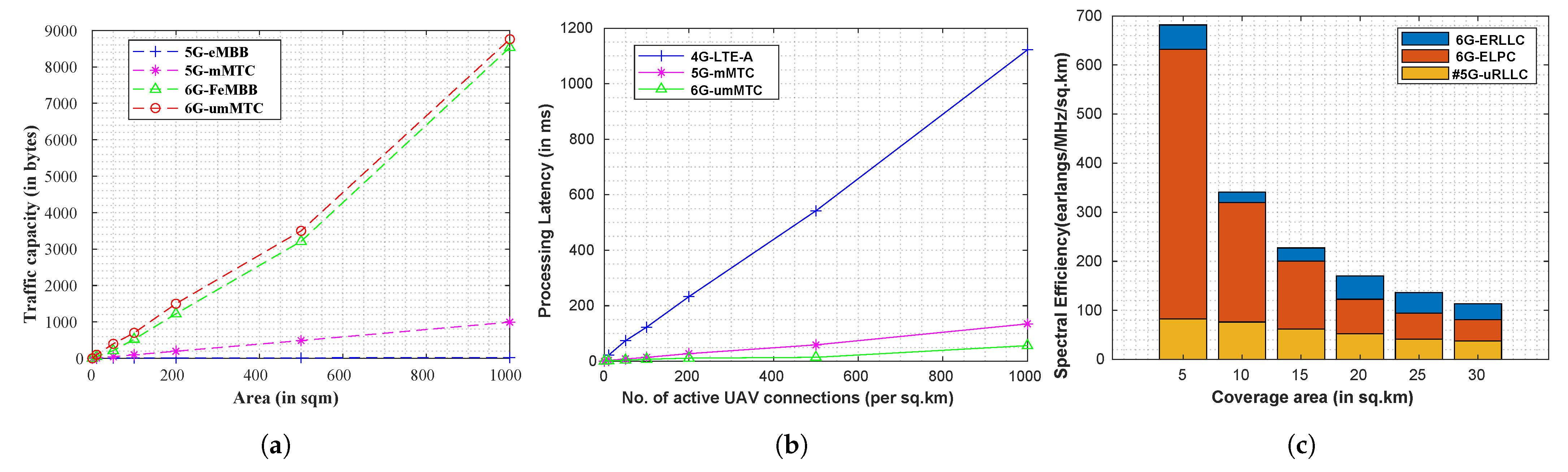
8.3.2. Result Analysis

As discussed in Section 5, we designate a decision variable D ( s ) which might result in three scenarios of local execution (UAV itself, and hence no offloading is required). In this case, the computation tasks T p are processed locally (suitable for lightweight tasks). In the case of data-intrinsic tasks, the data collected from UAVs are sent to the controller node, which offloads the data with a 6G-ERLLC link to E s e r . At E s e r (edge), tasks are divided and executed with the FL algorithm. Heavy tasks are sent to E c s for execution, which is offloaded from E s e r .
For local execution, we follow the approach as presented by authors in [58]. Figure 9a presents a comparative analysis of response time when task size varies. As more UAVs send data in batches, the task size increases, and thus the local execution shifts to edge execution, which shifts to cloud execution. Thus, offloading time is added to the response time, which is evident from the figure. As an example, for a task size of 100 MB, the cloud execution time is 8634 ms, edge execution time is 6789 ms, and local UAV execution is 6011 ms. Thus, at the edge, an offloading time of 778 ms is added, and from E s e r to E c s , the additional time of 1845 ms is recorded. The time between edge–cloud becomes further intensified owing to the FL gradient computation and parameter communication. Thus, to address this challenge, a future scope might include optimal control over FL accuracy vs. the response time to edge nodes.
Next, we analyze the impact of the FL learning algorithm on the batch size. We measure the energy dissipation requirements when the FL model is updated in the cloud (global update) against the update at edge nodes (local update). Finally, for small updates in terms of topology and route formation, the UAV swarm nodes run tiny ML algorithms which can be supported on-device, and hence there is no requirement for parameter update. Figure 9b presents these scenarios. As evident, for a batch size of 120 MB, the dissipated energy is 1089 kJ for cloud-based execution, 887 kJ for edge-based execution, and 802 kJ for on-device execution. On average, a significant improvement of 19.59% is recorded when edge execution takes place over cloud execution (where the FedAvg algorithm optimizes the training parameters).
Finally, we analyze the gradient computation delay with respect to local batch size, L b k , where edge nodes use the local learning and loss functions. Figure 9c presents the details. For a single round, we consider data sizes of { 512 , 1024 , 2048 , 4096 , 8192 , 16384 } bytes. Please note that it is not required that data need to be in exact powers of 2, but for simplicity, we enforced the condition. As evident, with increased size, the learning and loss convergence rate increases, and thus the time to compute the optimal gradient increases.

8.4. Discussion and Open Challenges

The section discusses the potential challenges of the scheme. The same are discussed as follows:
  • 6G channel characteristics: The presented scheme considers the deployment of a UAV swarm setup, where they are controlled through a controller node. In such cases, we considered 6G communication networks for effective UAV set up, where we analyze the performance based on 6G frequency and bandwidth ranges on the MATLAB simulation tool. However, in practicality, the performance and robustness would depend significantly on the size of the UAV swarm network and the fading model estimation. Moreover, the lack of open standards for 6G communication channels hinders the accurate modeling of the UAV setups. Thus, an open challenge is the standardization of 6G standards, which would allow homogeneity in the overall communication process.
  • Accuracy of non-stationary FoR estimation: Moreover, we considered that objects are in non-stationary FoR, and thus the object detection accuracy (estimation of the bounding boxes) significantly depends on the velocity of the object. In our simulation, we considered the YOLOv3 model owing to its improved detection accuracy in real time. The algorithm achieves a fine balance between the detection speed against accuracy, which is essential for non-stationary FoR, but the inherent model complexity adds overhead to the overall model. In YOLOv3, a convolutional neural network is formed, where the location and class information of the object is fed as input. A deep feature map is formed, and in our simulations, we experienced a significant loss in spatial features. Thus, the person localization in moving frames has low accuracy compared with stationary FoR. In such cases, a future approach is moving towards shallow feature maps, which form a higher response towards the spatial features and improve the model accuracy.
  • Challenges in FL setups: In our approach, we considered that edge nodes ( E s e r ) deploying local FL models and communicating the gradients to the global cloud server. The setups and simulations are promising for small setups, but in real life, a massive number of edge nodes are required to realize our 3FFs operations in a wide range. Moreover, the UAV swarm network controller nodes would increase, and thus, the local computations would become expensive. In such cases, a potential challenge is to address an optimized communication model that sends the updates (gradients) efficiently. In simulations, owing to a small setup, we ignored the communication overheads in the FL communications. Secondly, FL devices (smartphones and laptops) have limited computing capability, and the increase in network size requires low-powered protocols at the network and transport layers. In such cases, hybrid approach (both connectionless and connection-oriented) link setups are required, which can be fine-tuned with software emulation functions in the 6G networks. At last, the data under consideration in our simulations have fewer data-point variations, and thus preserve the non-identically distributed (non-id) considerations. In large setups, the statistical heterogeneity might violate the frequency distributions, which increases the training time of the overall network. The loss optimization at the global model is slower in such cases.

9. Conclusions

The article proposed a 6G-envisioned UAV scheme where basic avoidance operations to tackle COVID-19 and future pandemics are discussed. A 3FFs mechanism (social distancing, sanitizing, and inspection and monitoring) of COVID-19-infected patients is presented. The proposed scheme frames a layered architecture, where the governance layer presents the guidelines for 3FFs monitoring through UAVs (to minimize human intervention) against the backdrop of the 6G communication layer. 6G allows real-time monitoring and information transfer between entities. Finally, to track 3FFs violations, social distance monitoring and thermal inspection through the YOLOv3 and the MEDICAS thermal imaging system are considered. For mass sanitization, hexacopter and octocopter drones with high load-carrying capacities are considered. The computations take into account the data-centric computations at UAVs, and thus the FL-based computational offloading process is presented at the edge network. We considered the use case where a person might be located in a non-stationary FoR, and discussed how geo-fencing is possible to impose the 3FFs norms. In the simulation, performance metrics in terms of network parameters, computational offloading, and FL setup is considered. In network characteristics, the scheme is compared against traditional 5G-assisted UAV channels, and the presented results indicate the effectiveness of 6G-assisted UAVs in meeting 3FFs operations. To realize the benefits of edge computation, a comparative analysis of cloud, edge, and local UAV computation is proposed. A significant improvement of 778 ms is recorded in executing tasks on edge rather than the cloud, for a task size of 100 MB. Next, the energy dissipation is measured, and the edge records an improvement of 19.59 % over cloud execution. Finally, the open issues and research challenges in deploying the proposed scheme are presented, with potential solutions..
In the future, to address security and privacy issues of exchanged data of infected patients in different tagged zones, a decentralized UAV model over the blockchain network will be explored to facilitate trust, immutability, and traceability of transactions.

Author Contributions

Conceptualization: R.G., A.T., P.B. and S.T.; writing—original draft preparation: R.G., M.S.R., F.-E.Ț. and P.B.; methodology: P.B., F.A., A.T. and S.T.; writing—review and editing: S.T., M.S.R., A.T. and R.S.; Software: P.B., R.S., R.G. and S.T.; Visualization: F.-E.Ț., F.A., M.S.R. and R.S.; Investigation: P.B., R.S., F.A. and S.T. All authors have read and agreed to the published version of the manuscript.

Funding

This work was funded by the Researchers Supporting Project No. (RSP2022R509) King Saud University, Riyadh, Saudi Arabia.

Institutional Review Board Statement

Not applicable.

Informed Consent Statement

Not applicable.

Data Availability Statement

No data are associated with this research work.

Acknowledgments

This work was funded by the Researchers Supporting Project No. (RSP2022R509) King Saud University, Riyadh, Saudi Arabia. Also, this work is also supported by a grant from the Gheorghe Asachi Technical University of Iași: postdoctoral research—2022 and POCU—InoHubDoc. The results were obtained with the support of the Ministry of Investments and European Projects through the Human Capital Sectoral Operational Program 2014–2020, Contract no. 62461/03.06.2022, SMIS code 153735. This work is supported by Ministry of Research, Innovation, Digitization from Romania by the National Plan of R & D, Project PN 19 11, Subprogram 1.1. Institutional performance-Projects to finance excellence in RDI, Contract No. 19PFE/30.12.2021 and a grant of the NationalCenter for Hydrogen and Fuel Cells (CNHPC)—Installations and Special Objectives of National In-terest (IOSIN). This paper was partially supported by UEFISCDI Romania and MCI through BEIA projects ArtiPred, ALPHA, NGI-UAV-AGRO, Inno4Health, AICOM4Health, SmarTravel, Mad@Work and by European Union’s Horizon 2020 research and innovation program under grant agreements No. 101073982 (MOBILISE) and No. 883441 (STAMINA).

Conflicts of Interest

The authors declare no conflict of interest.

References

  1. Shi, P.; Dong, Y.; Yan, H.; Zhao, C.; Li, X.; Liu, W.; He, M.; Tang, S.; Xi, S. Impact of temperature on the dynamics of the COVID-19 outbreak in China. Sci. Total. Environ. 2020, 728, 138890. [Google Scholar] [CrossRef] [PubMed]
  2. Masud, M.; Alshehri, M.; Alroobaea, R.; Mohammad, S. Leveraging Convolutional Neural Network for COVID-19 Disease Detection Using CT Scan Images. Intell. Autom. Soft Comput. 2021, 29, 1–13. [Google Scholar] [CrossRef]
  3. COVID-19 Coronavirus Pandemic. Available online: https://www.worldometers.info/coronavirus/ (accessed on 8 November 2022).
  4. Wang, W.; Tang, J.; Wei, F. Updated understanding of the outbreak of 2019 novel coronavirus (2019-nCoV) in Wuhan, China. J. Med. Virol. 2020, 92, 441–447. [Google Scholar] [CrossRef] [PubMed]
  5. Mistry, C.; Thakker, U.; Gupta, R.; Obaidat, M.S.; Tanwar, S.; Kumar, N.; Rodrigues, J.J.P.C. MedBlock: An AI-enabled and Blockchain-driven Medical Healthcare System for COVID-19. In Proceedings of the ICC 2021—IEEE International Conference on Communications, Montreal, QC, Canada, 14–23 June 2021; pp. 1–6. [Google Scholar] [CrossRef]
  6. Verma, A.; Bhattacharya, P.; Zuhair, M.; Tanwar, S.; Kumar, N. VaCoChain: Blockchain-Based 5G-Assisted UAV Vaccine Distribution Scheme for Future Pandemics. IEEE J. Biomed. Health Inform. 2022, 26, 1997–2007. [Google Scholar] [CrossRef] [PubMed]
  7. Marinella, M.A. COVID-19 pandemic and the stethoscope: Don’t forget to sanitize. Heart Lung 2020, 49, 350. [Google Scholar] [CrossRef]
  8. Vos, J.D. The effect of COVID-19 and subsequent social distancing on travel behavior. Transp. Res. Interdiscip. Perspect. 2020, 5, 100121. [Google Scholar] [CrossRef]
  9. Shah, H.; Shah, S.; Tanwar, S.; Gupta, R.; Kumar, N. Fusion of AI Techniques to Tackle COVID-19 Pandemic: Models, Incidence Rates, and Future Trends. Multimed. Syst. 2021, 28, 1189–1222. [Google Scholar] [CrossRef]
  10. Lydia, L.; Anupama, C.; Beno, A.; Elhoseny, M.; Alshehri, M.; Selim, M. Cognitive computing-based COVID-19 detection on Internet of things-enabled edge computing environment. Soft Comput. 2021, 1–12. [Google Scholar] [CrossRef]
  11. How Drones Can Help Fight the Coronavirus, Mecatus Center, George Mason University. Available online: https://www.mercatus.org/system/files/skorup-drones-coronavirus-mercatus-v1.pdf (accessed on 8 November 2021).
  12. Gupta, R.; Kumari, A.; Tanwar, S. A taxonomy of blockchain envisioned edge-as-a-connected autonomous vehicles. Trans. Emerg. Telecommun. Technol. 2021, 32, e4009. [Google Scholar] [CrossRef]
  13. Bhattacharya, P. Co Existence of Packets and Bursts in High Speed Networks. Ph.D. Thesis, Dr. A.P.J. Abdul Kalam Technical University, Lucknow, India. Available online: http://shodhganga.inflibnet.ac.in:8080/jspui/handle/10603/332953 (accessed on 19 July 2022).
  14. Zhang, Z.; Xiao, Y.; Ma, Z.; Xiao, M.; Ding, Z.; Lei, X.; Karagiannidis, G.K.; Fan, P. 6G Wireless Networks: Vision, Requirements, Architecture, and Key Technologies. IEEE Veh. Technol. Mag. 2019, 14, 28–41. [Google Scholar] [CrossRef]
  15. Sanghvi, J.; Bhattacharya, P.; Tanwar, S.; Gupta, R.; Kumar, N.; Guizani, M. Res6Edge: An Edge-AI Enabled Resource Sharing Scheme for C-V2X Communications towards 6G. In Proceedings of the 2021 International Wireless Communications and Mobile Computing (IWCMC), Harbin City, China, 28 June–2 July 2021; pp. 149–154. [Google Scholar] [CrossRef]
  16. Zuhair, M.; Patel, F.; Navapara, D.; Bhattacharya, P.; Saraswat, D. BloCoV6: A blockchain-based 6G-assisted UAV contact tracing scheme for COVID-19 pandemic. In Proceedings of the 2021 2nd International Conference on Intelligent Engineering and Management (ICIEM), London, UK, 28–30 April 2021; pp. 271–276. [Google Scholar] [CrossRef]
  17. Yeh, C.; Jo, G.D.; Ko, Y.J.; Chung, H.K. Perspectives on 6G wireless communications. ICT Express 2022. [Google Scholar] [CrossRef]
  18. Technical Specification ITU-T FG-ML5G-ARC5G Unified architecture for machine learning in 5G and Future Networks. Available online: https://www.itu.int/en/ITU-T/focusgroups/ml5g/Documents/ML5G-delievrables.pdf (accessed on 20 July 2022).
  19. Verma, A.; Bhattacharya, P.; Saraswat, D.; Tanwar, S.; Kumar, N.; Sharma, R. SanJeeVni: Secure UAV-envisioned Massive Vaccine Distribution for COVID-19 Underlying 6G Network. IEEE Sens. J. 2022. [Google Scholar] [CrossRef]
  20. Verma, A.; Bhattacharya, P.; Bodkhe, U.; Saraswat, D.; Tanwar, S.; Dev, K. FedRec: Trusted rank-based recommender scheme for service provisioning in federated cloud environment. Digit. Commun. Netw. 2022. [Google Scholar] [CrossRef]
  21. Xing, Y.; Carlson, C.; Yuan, H. Optimize Path Planning for UAV COVID-19 Test Kits Delivery System by Hybrid Reinforcement Learning. In Proceedings of the 2022 IEEE 12th Annual Computing and Communication Workshop and Conference (CCWC), Las Vegas, NV, USA, 26–29 January 2022; pp. 0177–0183. [Google Scholar] [CrossRef]
  22. Rezaee, K.; Ghayoumi Zadeh, H.; Chakraborty, C.; Khosravi, M.R.; Jeon, G. Smart Visual Sensing for Overcrowding in COVID-19 Infected Cities Using Modified Deep Transfer Learning. IEEE Trans. Ind. Inform. 2022. [Google Scholar] [CrossRef]
  23. Suraci, C.; Pizzi, S.; Montori, F.; Di Felice, M.; Araniti, G. 6G to Take the Digital Divide by Storm: Key Technologies and Trends to Bridge the Gap. Future Internet 2022, 14, 189. [Google Scholar] [CrossRef]
  24. Shao, Z.; Cheng, G.; Ma, J.; Wang, Z.; Wang, J.; Li, D. Real-Time and Accurate UAV Pedestrian Detection for Social Distancing Monitoring in COVID-19 Pandemic. IEEE Trans. Multimed. 2022, 24, 2069–2083. [Google Scholar] [CrossRef]
  25. Harfina, D.; Zaini, Z.; Wulung, W. Disinfectant Spraying System with Quadcopter Type Unmanned Aerial Vehicle (UAV) Technology as an Effort to Break the Chain of the COVID-19 Virus. J. Robot. Control (JRC) 2021, 2, 502–507. [Google Scholar] [CrossRef]
  26. Janjua, M.B.; Duranay, A.E.; Arslan, H. Role of wireless communication in healthcare system to cater disaster situations under 6G vision. Front. Commun. Netw. 2020, 1, 610879. [Google Scholar] [CrossRef]
  27. Kumari, A.; Gupta, R.; Tanwar, S. Amalgamation of blockchain and IoT for smart cities underlying 6G communication: A comprehensive review. Comput. Commun. 2021, 172, 102–118. [Google Scholar] [CrossRef]
  28. Barnawi, A.; Chhikara, P.; Tekchandani, R.; Kumar, N.; Boulares, M. A CNN-based scheme for COVID-19 detection with emergency services provisions using an optimal path planning. Multimed. Syst. 2021, 1–15. [Google Scholar] [CrossRef]
  29. Islam, S.M.M.; Grado, C.; Lubecke, V.; Lubecke, L.C. UAV Radar Sensing of Respiratory Variations for COVID-Type Disorders. In Proceedings of the 2020 IEEE Asia-Pacific Microwave Conference (APMC), Hong Kong, 8–11 December 2020; pp. 737–739. [Google Scholar] [CrossRef]
  30. Siriwardhana, Y.; De Alwis, C.; Gür, G.; Ylianttila, M.; Liyanage, M. The Fight Against the COVID-19 Pandemic with 5G Technologies. IEEE Eng. Manag. Rev. 2020, 48, 72–84. [Google Scholar] [CrossRef]
  31. Unmanned Aerial Vehicle (UAV) Based Smart Garbage Collection System and Method Thereof. Available online: https://curin.chitkara.edu.in/patents/unmanned-aerial-vehicle-uav-based-smart-garbage-collection-system-and-method-thereof/ (accessed on 16 November 2022).
  32. Kaur, P.; Harnal, S.; Tiwari, R.; Alharithi, F.S.; Almulihi, A.H.; Noya, I.D.; Goyal, N. A Hybrid Convolutional Neural Network Model for Diagnosis of COVID-19 Using Chest X-ray Images. Int. J. Environ. Res. Public Health 2021, 18, 12191. [Google Scholar] [CrossRef] [PubMed]
  33. Khurana, S.; Sharma, G.; Miglani, N.; Singh, A.; Alharbi, A.; Alosaimi, W.; Alyami, H.; Goyal, N. An intelligent fine-tuned forecasting technique for COVID-19 prediction using neuralprophet model. Comput. Mater. Contin. 2022, 71, 629–649. [Google Scholar]
  34. Loey, M.; El-Sappagh, S.; Mirjalili, S. Bayesian-based optimized deep learning model to detect COVID-19 patients using chest X-ray image data. Comput. Biol. Med. 2022, 142, 105213. [Google Scholar] [CrossRef] [PubMed]
  35. Chew, A.W.Z.; Zhang, L. Data-driven multiscale modelling and analysis of COVID-19 spatiotemporal evolution using explainable AI. Sustain. Cities Soc. 2022, 80, 103772. [Google Scholar] [CrossRef]
  36. Baker, S.R.; Bloom, N.; Davis, S.J.; Kost, K.J.; Sammon, M.C.; Viratyosin, T. The Unprecedented Stock Market Impact of COVID-19; Technical Report; National Bureau of Economic Research: Cambridge, MA, USA, 2020. [Google Scholar]
  37. Chauhan, H.; Gupta, D.; Gupta, S.; Singh, A.; Aljahdali, H.M.; Goyal, N.; Noya, I.D.; Kadry, S. Blockchain Enabled Transparent and Anti-Counterfeiting Supply of COVID-19 Vaccine Vials. Vaccines 2021, 9, 1239. [Google Scholar] [CrossRef]
  38. Gupta, K.; Bansal, S.; Goel, R. Uses of Drones In Fighting COVID-19 Pandemic. In Proceedings of the 2021 10th International Conference on System Modeling & Advancement in Research Trends (SMART), Moradabad, India, 10–11 December 2021; pp. 651–655. [Google Scholar] [CrossRef]
  39. Prasad, V.K.; Bhattacharya, P.; Bhavsar, M.; Verma, A.; Tanwar, S.; Sharma, G.; Bokoro, P.N.; Sharma, R. ABV-CoViD: An Ensemble Forecasting Model to Predict Availability of Beds and Ventilators for COVID-19 like Pandemics. IEEE Access 2022, 10, 74131–74151. [Google Scholar] [CrossRef]
  40. Letaief, K.B.; Chen, W.; Shi, Y.; Zhang, J.; Zhang, Y.A. The Roadmap to 6G: AI Empowered Wireless Networks. IEEE Commun. Mag. 2019, 57, 84–90. [Google Scholar] [CrossRef]
  41. Alsharif, M.H.; Kelechi, A.H.; Albreem, M.A.; Chaudhry, S.A.; Zia, M.S.; Kim, S. Sixth Generation (6G) Wireless Networks: Vision, Research Activities, Challenges and Potential Solutions. Symmetry 2020, 12, 676. [Google Scholar] [CrossRef]
  42. Bhattacharya, P.; Bodkhe, U.; Zuhair, M.; Rashid, M.; Liu, X.; Verma, A.; Kishan Dewangan, R. Amalgamation of blockchain and sixth-generation-envisioned responsive edge orchestration in future cellular vehicle-to-anything ecosystems: Opportunities and challenges. Trans. Emerg. Telecommun. Technol. 2021, e4410. [Google Scholar] [CrossRef]
  43. Tanwar, S.; Gupta, R.; Patel, M.M.; Shukla, A.; Sharma, G.; Davidson, I.E. Blockchain and AI-Empowered Social Distancing Scheme to Combat COVID-19 Situations. IEEE Access 2021, 9, 129830–129840. [Google Scholar] [CrossRef]
  44. SYENA-H10. Available online: http://www.thanos.in/products/ (accessed on 12 November 2022).
  45. ESPY Drones. Available online: https://espy-drones.business.site/ (accessed on 12 November 2022).
  46. NAL-OCTA drones. Available online: https://pib.gov.in/PressReleasePage.aspx?PRID=1771470 (accessed on 12 November 2022).
  47. AIR-6 Hexacopter. Available online: https://www.droneprovide.com/airbornerobotic.html (accessed on 12 November 2022).
  48. Sharma, K.; Singh, H.; Sharma, D.K.; Kumar, A.; Nayyar, A.; Krishnamurthi, R. Dynamic Models and Control Techniques for Drone Delivery of Medications and Other Healthcare Items in COVID-19 Hotspots. In Emerging Technologies for Battling COVID-19: Applications and Innovations; Al-Turjman, F., Devi, A., Nayyar, A., Eds.; Springer International Publishing: Cham, Switzerland, 2021; pp. 1–34. [Google Scholar] [CrossRef]
  49. Saraswat, D.; Bhattacharya, P.; Singh, A.; Verma, A.; Tanwar, S.; Kumar, N. Secure 5G-Assisted UAV Access Scheme in IoBT for Region Demarcation and Surveillance Operations. IEEE Commun. Stand. Mag. 2022, 6, 58–66. [Google Scholar] [CrossRef]
  50. MEDICAS. Available online: https://www.droneprovide.com/medicas.html (accessed on 12 November 2022).
  51. Savio, M.M.D.; Deepa, T.; Bonasu, A.; Anurag, T.S. Image Processing For Face Recognition Using HAAR, HOG, and SVM Algorithms. JoUrnal Phys. Conf. Ser. 2021, 1964, 062023. [Google Scholar] [CrossRef]
  52. Barnawi, A.; Chhikara, P.; Tekchandani, R.; Kumar, N.; Alzahrani, B. Artificial intelligence-enabled Internet of Things-based system for COVID-19 screening using aerial thermal imaging. Future Gener. Comput. Syst. 2021, 124, 119–132. [Google Scholar] [CrossRef] [PubMed]
  53. Yi, K.M.; Yun, K.; Kim, S.W.; Chang, H.J.; Jeong, H.; Choi, J.Y. Detection of Moving Objects with Non-stationary Cameras in 5.8 ms: Bringing Motion Detection to Your Mobile Device. In Proceedings of the 2013 IEEE Conference on Computer Vision and Pattern Recognition Workshops, Portland, OR, USA, 23–28 June 2013; pp. 27–34. [Google Scholar] [CrossRef]
  54. Boulogeorgos, A.A.; Alexiou, A.; Merkle, T.; Schubert, C.; Elschner, R.; Katsiotis, A.; Stavrianos, P.; Kritharidis, D.; Chartsias, P.; Kokkoniemi, J.; et al. Terahertz Technologies to Deliver Optical Network Quality of Experience in Wireless Systems Beyond 5G. IEEE Commun. Mag. 2018, 56, 144–151. [Google Scholar] [CrossRef]
  55. Wang, C.X.; Huang, J.; Wang, H.; Gao, X.; You, X.; Hao, Y. 6G Wireless Channel Measurements and Models: Trends and Challenges. IEEE Veh. Technol. Mag. 2020, 15, 22–32. [Google Scholar] [CrossRef]
  56. Al-Saman, A.; Mohamed, M.; Cheffena, M.; Moldsvor, A. Wideband Channel Characterization for 6G Networks in Industrial Environments. Sensors 2021, 21, 2015. [Google Scholar] [CrossRef]
  57. Dong, Y.; Dai, J.; Niu, K.; Wang, S.; Yuan, Y. Joint source-channel coding for 6G communications. China Commun. 2022, 19, 101–115. [Google Scholar] [CrossRef]
  58. Sun, S.; Zhang, G.; Mei, H.; Wang, K.; Yang, K. Optimizing Multi-UAV Deployment in 3-D Space to Minimize Task Completion Time in UAV-Enabled Mobile Edge Computing Systems. IEEE Commun. Lett. 2021, 25, 579–583. [Google Scholar] [CrossRef]
Figure 2. Monitoring, inspecting, sanitizing, and measuring social distancing in COVID-19 and future pandemics.
Drones 06 00381 g002
Figure 3. UAV-based architectural solution to deal with the COVID-19 pandemic.
Drones 06 00381 g003
Figure 4. 6G features for operating UAVs in the COVID-19 pandemic [40].
Drones 06 00381 g004
Figure 5. Federated task offloading scheme for 3FFs UAVs.
Drones 06 00381 g005
Figure 6. Non-stationery FoR estimation of persons with moving objects.
Drones 06 00381 g006
Figure 7. Comparative analysis of communication latency, density, and spectral efficiency of various communication networks in UAV deployment. (a) 6G service benefits for handling high traffic volumes. (b) Processing latency of UAV connection links of 6G over 5G. (c) Spectral efficiency of 6G over 5G channels.
Drones 06 00381 g007
Figure 8. Benefits of deploying 6G-enabled UAV over conventional 4G and 5G channels for responsive 3FFs management to tackle the fight against COVID-19 and future pandemics. (a) Improved UAV mobility of 6G over 5G services. (b) Radio loss and lifetime of 6G connections over 5G and 4G. (c) Impact on UE data rates of 6G over 4G and 5G.
Drones 06 00381 g008
Figure 9. Data-centric analysis: benefits of task offloading by UAV swarms/controllers to local edge nodes and analysis of FL computation. (a) A comparative analysis of response time (cloud–edge–UAV) based on task size. (b) A comparative analysis of energy dissipation (global vs. local vs. on-device training). (c) Gradient computation size (single-round) based on task size (in bytes).
Drones 06 00381 g009
Table 1. Classification and comparative analysis of 4G, 4.5G, 5G, and 6G against defined verticals to support 3FFs to tackle COVID-19 [18].
VerticalsParameters4G4.5G5G6G (Proposed)
CommunicationDrivers3GPP, LTELTE-A, WIMAXmMIMO, mmWave, eMBB, URLLC, mMTCFeMBB, ERLLC, umMTC, LDHMC, ELPC
Frequency band2–8 GHz2–8 GHz3–300 GHz0.1–10 THz
Uplink/Downlink128/56 Mbps3/1.5 Gbps20/10 Gbps52.6/24.25 Gbps
Peak data rate100 Mbps1.5 Gbps20 Gbps1 Tbps
Edge devices data rate1 Mbps10 Mbps0.1 Gbps1–10 Gbps
RTT latency (in ms)20 ms10 ms1 ms10–100 μ s
Spectral efficiency300 bps/Hz30 bps/Hz120 bps/Hz600–1200 bps/Hz
Connected devices 10 4 devices/km2 10 5 devices/km2 10 6 devices/km2 10 7 devices/km2
UAVsCell size6 GHz umbrella small dense cellsmmWave cells of 100 m (fixed)<100 m tiny cells with dense mmWavetiny THz cells with cell-free smart surfaces
Coverage range50–80 m2 km100–150 km1500–2000 km
Payload weight16 g750 g4.9–50 km150 km
Flying mechanismMulti-rotorFixed-wingMulti-rotorMulti-rotor
Speed & Flying time80 km/h & 6–8 min100 km/h & 45 min150 km/h & 180 min482 km/h & 1800 min
Energy efficiency1× J10× J100× J1000× J
Power supply3.7 V/160 mAh Li-battery2700 mAh-3-cell LiPo batteryLiPo Battery (10,000–15000 mAh)950-shaft-horsepower-turbo-propellant-engine
COVID-19 3FFs UAVsRadio-only hop delay (in nanoseconds (ns))10010010<1
Processing delay (in ns)1005010<1
Base station-UAV communication delay10 ms5 ms0.5 ms50 μ s
End-to-end reliability (in %)99.9999.99999.9999999.9999999
Mobility300 km/h350 km/h500 km/h≥1000 km/h
Area traffic capacity0.1 Mb/s/m21 Mb/s/m210 Mb/s/m21 Gb/s/m2
TechnologyOFDM, MIMO, D2D, HetNetsCarrier aggregation, Turbo codesmm-Wave, mMIMO, LDPC, Planar codes, NOMA, Ultra-denseSM-MIMO, LIS, HBF, OAM MuX, Laser, VLC, Blockchain-based spectrum, Quantum entanglement, Coverage maximization over ML/DL algorithms.
3GPP: Third-Generation Partnership Project; LTE: Long-Term Evolution; LTE-A: LTE-Advanced; WiMAX: Worldwide Interoperability for Microwave Access; mMIMO: Massive Multiple-Input, Multiple-Output; mmWave: MillimeterWave; eMBB: Enhanced Mobile Broadband; URLLC: Ultra-Reliable Low-Latency Communications; mMTC: Massive Machine Type Communications; FeMBB: Further-Enhanced Mobile Broadband; ERLLC: Extremely Reliable and Low-Latency Communications; umMTC: Ultra-Massive Machine-Type Communications; LDMHC: Long-Distance and High-Mobility Communications; ELPC: Extremely Low-Power Communications; GHz: Gigahertz; THz: Terahertz; Mbps: Megabit Per Second; Gbps: Gigabit Per Second; Tbps: Terabit Per Second; LiPo: Lithium–Polymer; OFDM: Orthogonal Frequency Division Multiplexing; D2D: Device-to-Device; HetNets: Heterogeneous Networks; NOMA: Non-Orthogonal Multiple Access; LDPC: Low-Density Parity Check; Codes; HBF: Holographic Beam-Forming; SM-MIMO: Super-Massive MIMO; OAM: Operations, Administration, and Maintenance; VLC: Visible-Light Communication; LIS: Large-Intelligent Surfaces; MuX: Multiplexer; ML: Machine Learning; DL: Deep-Learning.
Table 2. A comparative analysis of the proposed scheme against existing schemes.
AuthorYearParametersObjectiveAdvantagesLimitations
12345
Proposed2022YYYYYA 6G-enabled monitoring and control ecosystem is proposed to curb the COVID-19 virus transmissibilityA UAV-based scheme is presented that highlights the importance of social distancing, sanitization, and control of 3FFs to tackle COVID-19 and future pandemicsThe proposed work addresses the issues at the UAV-networking front but does not present insights towards UAV security
Xing et al. [21]2022YNNYYThe UAV path planning scheme is presented to deliver the COVID-19 testing kitsA hybrid RL scheme optimizes the UAV trip times and maintains an optimal delivery sequence from a given source to multiple destinationsTo support the RL operations, discussions on effective UAV uplink rate are not considered
Rezaee et al. [22]2022YYNNNA virtual sensing UAV detection algorithm for crowded regions is considered for COVID-19 patientsWCA algorithm is combined with DTL for object detection, which improves monitoring accuracyChallenges such as scene overlapping, non-human subject classification, and pixel occlusion are not considered
Suraci et al. [23]2022YYYNNThe benefits of 6G are discussed for COVID-19 to simplify the overall model predictionA digital-divide concept (users and machines) interplay with 6G is presented to leverage massive UAV connectivity, which improves the service outreach to last-mile usersSpecific use cases in healthcare, AR/VR, are discussed, but latency constraints are not highlighted
Verma et al. [19]2022YNYYYA 6G-based UAV vaccine distribution scheme is proposed that couples blockchain for chronological registrations of usersA scheme named SanJeeVni addresses the UAV distribution and registration challenges, where UAV is supported over a 6G-TI networkCOVID-19 monitoring and social distancing measures to curb the virus spread are not presented
Shao et al. [24]2021YYNYYUAV-based social distancing monitoring is proposed, where captured UAV frames are diagnosed for distance measurements between two usersYOLOv3 with SSD is used for object head and movement detections, and an alarm is raised if distance falls below an acceptable levelWind velocity and nearby UAV interference are not considered in the model computation
Harfina et al. [25]2021NYNNNUAV quadcopter design for disinfectant spray over surfacesThe quadcopter is designed over a 2200 KV motor and the design is capable of carrying 200 mL of disinfectantHigher load specifications require additional UAV hardware, which increases the design cost
Janjua et al. [26]2021NYYYYExplored the 6G impact on disaster control ecosystems with UAVsA responsive design unit is presented over 6G services to support variable linksCommunication topology is highly mobile, thus a single BS faces a stringent bottleneck in serving the UAV response units
Gupta et al. [27]2021YYYYNAn edge-intelligence framework to tackle massive application data and complex task frameworks for COVID-19 is presentedEdge-intelligence framework to support vehicles, UAVs, and holographic communication in smart cities is discussedTrusted edge task offloading and learning are not discussed
Barnawi et al. [28]2021YYNYNThe UAV-based medical delivery scheme is coupled with COVID-19 classificationA CNN approach for COVID-19 X-ray detection of positive cases over negative cases (pneumonia) is presentedThe loss function of the CNN classifier leads to a higher dropout rate
Islam et al. [29]2020YYNNNRadar-based UAV to detect common patterns of COVID-19Respiration rate and displacement are sensed, and the classification of COVID-19 cases is presented.The designed radar method requires high-end calibration to improve accuracy
Siriwardhana et al. [30]2020NYNYNPotential use cases of 5G and IoT for COVID-19 detection and control are presentedReal-time responsive management in contact tracing and delivery supply chains is discussedEffective solutions and frameworks are not discussed in greater depth
1—AI adoption, 2—COVID-19 monitoring and control, 3—6G services, 4—latency assessment, 5—link rate assessment, Y—shows that the parameter is considered, and N—shows that the parameter is not considered.
Table 3. Technical specifications of UAVs for sanitization.
DronesSYENA-H10 [44]ESPY [45]NAL-OCTA [46]AIR-6 [47]
Specification
Hexcopter TypeMulti-copterMulti-copterOctcopterHexacopter
Propellers dimension1700 × 1500 × 710 (mm Opened)609.6 × 447.04 mmNot specified774.7 × 774.7 × 424.18 mm
Tank (payload) Capacity5, 10, 15 L12 L18 L15 L
Flight take-off time20 min15 min20 min30 min
Wind resistanceyes (Level 5)Level 410 m/s (Level 3)Level 5
Coverage area60 acres/day214 acres/dayNot specifiedNot specified
Table 4. Simulation parameters of 6G-based communication layer.
Network ParametersValue
Frequency Range102.1 GHz
Channel bandwidth2.3 GHz
Delay Spread0.56 (ns)
Channel modelRayleigh Fading
ModulationOrthogonal Time Frequency Space (OTFS)
Channel codingPolar codes
Table 5. FL and UAV parameters.
ParameterValue
Number of swarm networks2
UAVs/Swarm5
UAV Flying altitude40 m
Edge nodes2
Transmission power0.2 W
Input data sizeUniform distribution
E c s propagation delay25 ms
E c s capability30 GHz
FL algorithmFedAvg
η 0.001
Batch-sizeMin-batch
Epochs10,000
Log_interval10
ActivationReLU
Publisher’s Note: MDPI stays neutral with regard to jurisdictional claims in published maps and institutional affiliations.

