
Drone-Based Monitoring to Remotely Assess a Beach Nourishment Program on Lord Howe Island


Abstract
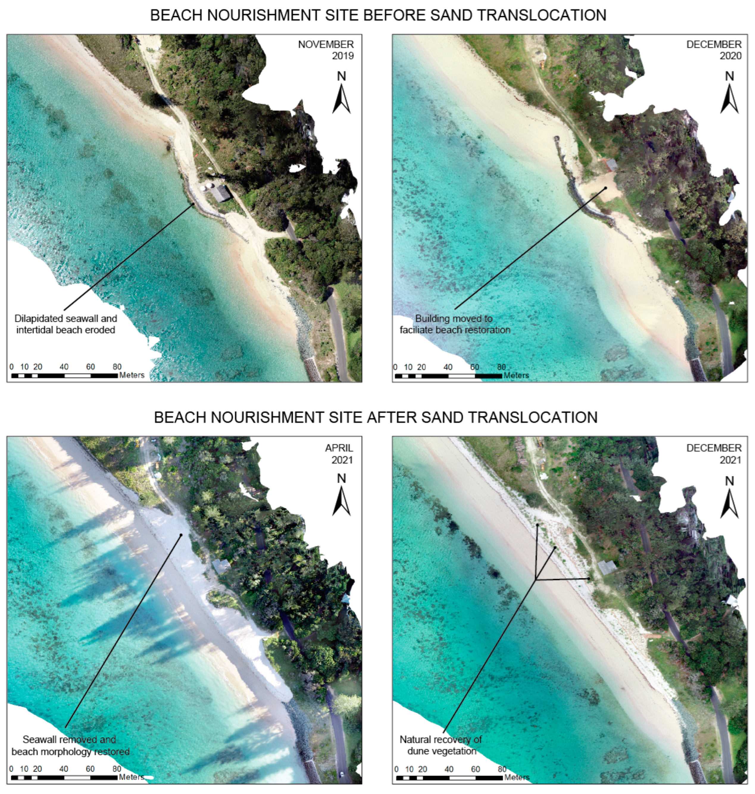
:1. Introduction
2. Materials and Methods
2.1. Study Location and Sampling Methodology
2.2. Analysis of Data
3. Results
4. Discussion
5. Conclusions
Author Contributions
Funding
Data Availability Statement
Acknowledgments
Conflicts of Interest
References
- Cooper, J.A.G.; McKenna, J. Working with natural processes: The challenge for coastal protection strategies. Geogr. J. 2008, 174, 315–331. [Google Scholar] [CrossRef]
- Hapke, C.; Reid, D.; Richmond, B.M.; Ruggiero, P.; List, J. National Assessment of Shoreline Change Part 3: Historical Shoreline Change and Associated Coastal Land Loss along Sandy Shorelines of the California Coast; Open-File Report 2006-1219; U.S. Geological Survey: Reston, VA, USA, 2006. [Google Scholar]
- Leo, K.L.; Gillies, C.L.; Fitzsimons, J.A.; Hale, L.Z.; Beck, M.W. Coastal habitat squeeze: A review of adaptation solutions for saltmarsh, mangrove and beach habitats. Ocean Coast. Manag. 2019, 175, 180–190. [Google Scholar] [CrossRef]
- Asari, N.; Suratman, M.N.; Mohd Ayob, N.A.; Abdul Hamid, N.H. Mangroves as a natural barrier to environmental risks and coastal protection. In Mangroves: Ecology, Biodiversity and Management; Springer Nature: Singapore, 2021; pp. 305–322. [Google Scholar]
- Sudha Rani, N.N.V.; Satyanarayana, A.N.V.; Bhaskaran, P.K. Coastal vulnerability assessment studies over India: A review. Nat. Hazards 2015, 77, 405–428. [Google Scholar] [CrossRef]
- Besset, M.; Gratiot, N.; Anthony, E.J.; Bouchette, F.; Goichot, M.; Marchesiello, P. Mangroves and shoreline erosion in the Mekong River delta, Vietnam. Estuar. Coast. Shelf Sci. 2019, 226, 106263. [Google Scholar] [CrossRef]
- Martínez, M.L.; Psuty, N.P. Coastal Dunes: Ecology and Conservation; Springer: Berlin/Heidelberg, Germany, 2004. [Google Scholar]
- Anthony, E.J.; Brunier, G.; Besset, M.; Goichot, M.; Dussouillez, P.; Nguyen, V.L. Linking rapid erosion of the Mekong River delta to human activities. Sci. Rep. 2015, 5, 14745. [Google Scholar] [CrossRef] [PubMed]
- Jordan, C.; Tiede, J.; Lojek, O.; Visscher, J.; Apel, H.; Nguyen, H.Q.; Quang, C.N.X.; Schlurmann, T. Sand mining in the Mekong Delta revisited—Current scales of local sediment deficits. Sci. Rep. 2019, 9, 17823. [Google Scholar] [CrossRef]
- Kennish, M.J. Coastal salt marsh systems in the U.S.: A review of anthropogenic impacts. J. Coast. Res. 2001, 17, 731–748. [Google Scholar]
- Žilinskas, G.; Janušaitė, R.; Jarmalavičius, D.; Pupienis, D. The impact of Klaipėda Port entrance channel dredging on the dynamics of coastal zone, Lithuania. Oceanologia 2020, 62, 489–500. [Google Scholar] [CrossRef]
- Leafe, R.; Pethick, J.; Townend, I. Realising the benefits of shoreline management. Geogr. J. 1998, 164, 282–290. [Google Scholar] [CrossRef]
- Rangel-Buitrago, N.; Neal, W.J.; de Jonge, V.N. Risk assessment as tool for coastal erosion management. Ocean Coast. Manag. 2020, 186, 105099. [Google Scholar] [CrossRef]
- Cai, F.; Su, X.; Liu, J.; Li, B.; Lei, G. Coastal erosion in China under the condition of global climate change and measures for its prevention. Prog. Nat. Sci. 2009, 19, 415–426. [Google Scholar] [CrossRef]
- Toimil, A.; Camus, P.; Losada, I.J.; Le Cozannet, G.; Nicholls, R.J.; Idier, D.; Maspataud, A. Climate change-driven coastal erosion modelling in temperate sandy beaches: Methods and uncertainty treatment. Earth-Sci. Rev. 2020, 202, 103110. [Google Scholar] [CrossRef]
- Hanley, M.E.; Bouma, T.J.; Mossman, H.L. The gathering storm: Optimising management of coastal ecosystems in the face of a climate-driven threat. Ann. Bot. 2020, 125, 197–212. [Google Scholar] [CrossRef]
- Passeri, D.L.; Hagen, S.C.; Medeiros, S.C.; Bilskie, M.V.; Alizad, K.; Wang, D. The dynamic effects of sea level rise on low-gradient coastal landscapes: A review. Earth’s Future 2015, 3, 159–181. [Google Scholar] [CrossRef]
- Neal, W.J.; Bush, D.M.; Pilkey, O.H. Managed Retreat. In Encyclopedia of Engineering Geology; Encyclopedia of Earth Sciences Series; 2017; pp. 1–7. Available online: https://link.springer.com/referenceworkentry/10.1007/978-3-319-48657-4_201-2 (accessed on 5 July 2023).
- Sutton-Grier, A.E.; Wowk, K.; Bamford, H. Future of our coasts: The potential for natural and hybrid infrastructure to enhance the resilience of our coastal communities, economies and ecosystems. Environ. Sci. Policy 2015, 51, 137–148. [Google Scholar] [CrossRef]
- Masselink, G.; Russell, P.; Rennie, A.; Brooks, S.; Spencer, T. Impacts of climate change on coastal geomorphology and coastal erosion relevant to the coastal and marine environment around the U.K. MCCIP Sci. Rev. 2020, 2020, 158–189. [Google Scholar]
- Williams, A.; Rangel-Buitrago, N.; Pranzini, E.; Anfuso, G. The management of coastal erosion. Ocean Coast. Manag. 2018, 156, 4–20. [Google Scholar] [CrossRef]
- French, P.W. Coastal Defences: Processes, Problems and Solutions; Routledge: London, UK, 2002. [Google Scholar]
- Sundar, V.; Sannasiraj, S.; Murali, K.; Singaravelu, V. Impact of coastal structure on shorelines along the southeast and southwest coasts of India. ISH J. Hydraul. Eng. 2022, 28, 1–19. [Google Scholar] [CrossRef]
- Arnall, A. Where land meets sea: Islands, erosion and the thing-power of hard coastal protection structures. Environ. Plan. E Nat. Space 2022, 6, 69–86. [Google Scholar] [CrossRef]
- Rangel-Buitrago, N.; Williams, A.T.; Anfuso, G. Hard protection structures as a principal coastal erosion management strategy along the Caribbean coast of Colombia. A chronicle of pitfalls. Ocean Coast. Manag. 2018, 156, 58–75. [Google Scholar] [CrossRef]
- Mamo, L.T.; Coleman, M.A.; Dwyer, P.G.; Kelaher, B.P. Listing may not achieve conservation: A call for proactive approaches to threatened species management. Aquat. Conserv. Mar. Freshw. Ecosyst. 2020, 30, 611–616. [Google Scholar] [CrossRef]
- Mamo, L.T.; Dwyer, P.G.; Coleman, M.A.; Dengate, C.; Kelaher, B.P. Beyond coastal protection: A robust approach to enhance environmental and social outcomes of coastal adaptation. Ocean Coast. Manag. 2022, 217, 106007. [Google Scholar] [CrossRef]
- Hallegatte, S.; Ranger, N.; Mestre, O.; Dumas, P.; Corfee-Morlot, J.; Herweijer, C.; Wood, R.M. Assessing climate change impacts, sea level rise and storm surge risk in port cities: A case study on Copenhagen. Clim. Chang. 2011, 104, 113–137. [Google Scholar] [CrossRef]
- Martyr-Koller, R.; Thomas, A.; Schleussner, C.-F.; Nauels, A.; Lissner, T. Loss and damage implications of sea-level rise on Small Island Developing States. Curr. Opin. Environ. Sustain. 2021, 50, 245–259. [Google Scholar] [CrossRef]
- Morris, R.L.; Konlechner, T.M.; Ghisalberti, M.; Swearer, S.E. From grey to green: Efficacy of eco-engineering solutions for nature-based coastal defence. Glob. Chang. Biol. 2018, 24, 1827–1842. [Google Scholar] [CrossRef] [PubMed]
- Silva, R.; Martínez, M.L.; van Tussenbroek, B.I.; Guzmán-Rodríguez, L.O.; Mendoza, E.; López-Portillo, J. A framework to manage coastal squeeze. Sustainability 2020, 12, 10610. [Google Scholar] [CrossRef]
- Davison, A.T.; Nicholls, R.J.; Leatherman, S.P. Beach nourishment as a coastal management tool: An annotated bibliography on developments associated with the artificial nourishment of beaches. J. Coast. Res. 1992, 8, 984–1022. [Google Scholar]
- Pinto, C.A.; Silveira, T.M.; Teixeira, S.B. Beach nourishment practice in mainland Portugal (1950–2017): Overview and retrospective. Ocean Coast. Manag. 2020, 192, 105211. [Google Scholar] [CrossRef]
- Cooke, B.C.; Jones, A.R.; Goodwin, I.D.; Bishop, M.J. Nourishment practices on Australian sandy beaches: A review. J. Environ. Manag. 2012, 113, 319–327. [Google Scholar] [CrossRef]
- de Schipper, M.A.; Ludka, B.C.; Raubenheimer, B.; Luijendijk, A.P.; Schlacher, T.A. Beach nourishment has complex implications for the future of sandy shores. Nat. Rev. Earth Environ. 2020, 2, 70–84. [Google Scholar] [CrossRef]
- Cooke, B.C.; Morton, J.K.; Baldry, A.; Bishop, M.J. Backshore nourishment of a beach degraded by off-road vehicles: Ecological impacts and benefits. Sci. Total Environ. 2020, 724, 138115. [Google Scholar] [CrossRef] [PubMed]
- Gares, P.A.; Wang, Y.; White, S.A. Using LIDAR to monitor a beach nourishment project at Wrightsville Beach, North Carolina, U.S.A. J. Coast. Res. 2006, 22, 1206–1219. [Google Scholar] [CrossRef]
- Reine, K.J. A Literature Review of Beach Nourishment Impacts on Marine Turtles; U.S. Army Corps of Engineers: Washington, DC, USA, 2022. [Google Scholar]
- Hagenaars, G.; de Vries, S.; Luijendijk, A.P.; de Boer, W.P.; Reniers, A.J.H.M. On the accuracy of automated shoreline detection derived from satellite imagery: A case study of the sand motor mega-scale nourishment. Coast. Eng. 2018, 133, 113–125. [Google Scholar] [CrossRef]
- Vos, K.; Harley, M.D.; Splinter, K.D.; Simmons, J.A.; Turner, I.L. Sub-annual to multi-decadal shoreline variability from publicly available satellite imagery. Coast. Eng. 2019, 150, 160–174. [Google Scholar] [CrossRef]
- Pucino, N.; Kennedy, D.M.; Carvalho, R.C.; Allan, B.; Ierodiaconou, D. Citizen science for monitoring seasonal-scale beach erosion and behaviour with aerial drones. Sci. Rep. 2021, 11, 3935. [Google Scholar] [CrossRef]
- White, S.A.; Wang, Y. Utilizing DEMs derived from LIDAR data to analyse morphologic change in the North Carolina coastline. Remote Sens. Environ. 2003, 85, 39–47. [Google Scholar] [CrossRef]
- Turner, I.L.; Harley, M.D.; Short, A.D.; Simmons, J.A.; Bracs, M.A.; Phillips, M.S.; Splinter, K.D. A multi-decade dataset of monthly beach profile surveys and inshore wave forcing at Narrabeen, Australia. Sci. Data 2016, 3, 160024. [Google Scholar] [CrossRef]
- Hamm, L.; Capobianco, M.; Dette, H.; Lechuga, A.; Spanhoff, R.; Stive, M. A summary of European experience with shore nourishment. Coast. Eng. 2002, 47, 237–264. [Google Scholar] [CrossRef]
- Kelaher, B.P.; Colefax, A.P.; Tagliafico, A.; Bishop, M.J.; Giles, A.; Butcher, P.A. Assessing variation in assemblages of large marine fauna off ocean beaches using drones. Mar. Freshw. Res. 2019, 71, 68–77. [Google Scholar] [CrossRef]
- Provost, E.J.; Coleman, M.A.; Butcher, P.A.; Colefax, A.; Schlacher, T.A.; Bishop, M.J.; Connolly, R.M.; Gilby, B.L.; Henderson, C.J.; Jones, A. Quantifying human use of sandy shores with aerial remote sensing technology: The sky is not the limit. Ocean Coast. Manag. 2021, 211, 105750. [Google Scholar] [CrossRef]
- Colefax, A.P.; Butcher, P.A.; Pagendam, D.E.; Kelaher, B.P. Reliability of marine faunal detections in drone-based monitoring. Ocean Coast. Manag. 2019, 174, 108–115. [Google Scholar] [CrossRef]
- Giones, F.; Brem, A. From toys to tools: The co-evolution of technological and entrepreneurial developments in the drone industry. Bus. Horiz. 2017, 60, 875–884. [Google Scholar] [CrossRef]
- Goncalves, J.A.; Henriques, R. UAV photogrammetry for topographic monitoring of coastal areas. ISPRS J. Photogramm. Remote Sens. 2015, 104, 101–111. [Google Scholar] [CrossRef]
- Joyce, K.E.; Fickas, K.C.; Kalamandeen, M. The unique value proposition for using drones to map coastal ecosystems. Camb. Prism. Coast. Futures 2023, 1, e6. [Google Scholar] [CrossRef]
- Escobar Villanueva, J.R.; Iglesias Martinez, L.; Perez Montiel, J.I. DEM Generation from fixed-wing UAV imaging and LiDAR-derived ground control points for flood estimations. Sensors 2019, 19, 3205. [Google Scholar] [CrossRef]
- Provost, E.J.; Butcher, P.A.; Coleman, M.A.; Bloom, D.; Kelaher, B.P. Aerial drone technology can assist compliance of trap fisheries. Fish. Manag. Ecol. 2020, 27, 381–388. [Google Scholar] [CrossRef]
- Hodgson, J.C.; Mott, R.; Baylis, S.M.; Pham, T.T.; Wotherspoon, S.; Kilpatrick, A.D.; Raja Segaran, R.; Reid, I.; Terauds, A.; Koh, L.P.; et al. Drones count wildlife more accurately and precisely than humans. Methods Ecol. Evol. 2018, 9, 1160–1167. [Google Scholar] [CrossRef]
- Kelaher, B.P.; Peddemors, V.M.; Hoade, B.; Colefax, A.P.; Butcher, P.A. Comparison of sampling precision for nearshore marine wildlife using unmanned and manned aerial surveys. J. Unmanned Veh. Syst. 2020, 8, 30–43. [Google Scholar] [CrossRef]
- Clothier, R.A.; Greer, D.A.; Greer, D.G.; Mehta, A.M. Risk perception and the public acceptance of drones. Risk Anal. 2015, 35, 1167–1183. [Google Scholar] [CrossRef]
- Colefax, A.P.; Butcher, P.A.; Kelaher, B.P.; Browman, H. The potential for unmanned aerial vehicles (UAVs) to conduct marine fauna surveys in place of manned aircraft. ICES J. Mar. Sci. 2018, 75, 1–8. [Google Scholar] [CrossRef]
- Provost, E.J.; Butcher, P.A.; Colefax, A.P.; Coleman, M.A.; Curley, B.G.; Kelaher, B.P. Using drones to quantify beach users across a range of environmental conditions. J. Coast. Conserv. 2019, 23, 633–642. [Google Scholar] [CrossRef]
- Harris, J.M.; Nelson, J.A.; Rieucau, G.; Broussard, W.P. Use of drones in fishery science. Trans. Am. Fish. Soc. 2019, 148, 687–697. [Google Scholar] [CrossRef]
- Kent, A.J.; Vujakovic, P. The Routledge Handbook of Mapping and Cartography; Routledge: London, UK, 2017. [Google Scholar]
- Dickson, M.; Kennedy, D.; Woodroffe, C. The influence of rock resistance on coastal morphology around Lord Howe Island, southwest Pacific. Earth Surf. Process. Landf. J. Br. Geomorphol. Res. Group 2004, 29, 629–643. [Google Scholar] [CrossRef]
- Christie, A.P.; Abecasis, D.; Adjeroud, M.; Alonso, J.C.; Amano, T.; Anton, A.; Baldigo, B.P.; Barrientos, R.; Bicknell, J.E.; Buhl, D.A.; et al. Quantifying and addressing the prevalence and bias of study designs in the environmental and social sciences. Nat. Commun. 2020, 11, 6377. [Google Scholar] [CrossRef]
- Anderson, M.J. Permutational Multivariate Analysis of Variance (PERMANOVA). In Wiley StatsRef: Statistics Reference Online; 2017; pp. 1–15. Available online: https://onlinelibrary.wiley.com/doi/10.1002/9781118445112.stat07841 (accessed on 5 July 2023).
- Armstrong, S.B.; Lazarus, E.D. Masked shoreline erosion at large spatial scales as a collective effect of beach nourishment. Earth’s Future 2019, 7, 74–84. [Google Scholar] [CrossRef]
- Blott, S.J.; Pye, K. Morphological and sedimentological changes on an artificially nourished beach, Lincolnshire, U.K. J. Coast. Res. 2004, 20, 214–233. [Google Scholar] [CrossRef]
- Dyson, A.; Victory, S.; Connor, T. Sand bypassing the Tweed River entrance: An overview. Proc. Coasts Ports 2001, 2001, 310–315. [Google Scholar]
- Ariffin, E.H.; Sedrati, M.; Akhir, M.F.; Daud, N.R.; Yaacob, R.; Husain, M.L. Beach morphodynamics and evolution of monsoon-dominated coasts in Kuala Terengganu, Malaysia: Perspectives for integrated management. Ocean Coast. Manag. 2018, 163, 498–514. [Google Scholar] [CrossRef]
- Bitan, M.; Zviely, D. Sand beach nourishment: Experience from the Mediterranean Coast of Israel. J. Mar. Sci. Eng. 2020, 8, 273. [Google Scholar] [CrossRef]
- Wanless, H.R.; Maier, K.L. An evaluation of beach renourishment sands adjacent to reefal settings, southeast Florida. Southeast. Geol. 2007, 45, 25–42. [Google Scholar]
- McLaughlin, S.; McKenna, J.; Cooper, J. Socio-economic data in coastal vulnerability indices: Constraints and opportunities. J. Coast. Res. 2002, 36, 487–497. [Google Scholar] [CrossRef]
- McLachlan, A.; Defeo, O. The Ecology of Sandy Shores; Academic Press: London, UK, 2018. [Google Scholar]
- Sigren, J.M.; Figlus, J.; Armitage, A.R. Coastal sand dunes and dune vegetation: Restoration, erosion, and storm protection. Shore Beach 2014, 82, 5–12. [Google Scholar]
- Seely, M.; Louw, G. First approximation of the effects of rainfall on the ecology and energetics of a Namib Desert dune ecosystem. J. Arid Environ. 1980, 3, 25–54. [Google Scholar] [CrossRef]
- Schlacher, T.A.; de Jager, R.; Nielsen, T. Vegetation and ghost crabs in coastal dunes as indicators of putative stressors from tourism. Ecol. Indic. 2011, 11, 284–294. [Google Scholar] [CrossRef]
- Hutton, I.; Parkes, J.P.; Sinclair, A.R.E. Reassembling island ecosystems: The case of Lord Howe Island. Anim. Conserv. 2007, 10, 22–29. [Google Scholar] [CrossRef]
- Nordstrom, K.F.; Gamper, U.; Fontolan, G.; Bezzi, A.; Jackson, N.L. Characteristics of coastal dune topography and vegetation in environments recently modified using beach fill and vegetation plantings, Veneto, Italy. Environ. Manag. 2009, 44, 1121–1135. [Google Scholar] [CrossRef]
- Nordstrom, K.F.; Jackson, N.L. Foredune restoration in urban settings. In Restoration of Coastal Dunes; Martínez, M.L., Gallego-Fernández, J.B., Hesp, P.A., Eds.; Springer: Berlin/Heidelberg, Germany, 2013; pp. 17–31. [Google Scholar]
- van der Wal, D. Aeolian Transport of Nourishment Sand in Beach-Dune Environments; University of Amsterdam: Amsterdam, The Netherlands, 1999. [Google Scholar]
- Gillan, J.K.; McClaran, M.P.; Swetnam, T.L.; Heilman, P. Estimating forage utilisation with drone-based photogrammetric point clouds. Rangel. Ecol. Manag. 2019, 72, 575–585. [Google Scholar] [CrossRef]
- Bishop, M.J.; Peterson, C.H.; Summerson, H.C.; Lenihan, H.S.; Grabowski, J.H. Deposition and long-shore transport of dredge spoils to nourish beaches: Impacts on benthic infauna of an ebb-tidal delta. J. Coast. Res. 2006, 22, 530–546. [Google Scholar] [CrossRef]
- Harley, M.D.; Turner, I.; Short, A.; Ranasinghe, R. A reevaluation of coastal embayment rotation: The dominance of cross-shore versus alongshore sediment transport processes, Collaroy-Narrabeen Beach, southeast Australia. J. Geophys. Res. Earth Surf. 2011, 116, F04033. [Google Scholar] [CrossRef]
- Gallop, S.L.; Kennedy, D.M.; Loureiro, C.; Naylor, L.A.; Muñoz-Pérez, J.J.; Jackson, D.W.; Fellowes, T.E. Geologically controlled sandy beaches: Their geomorphology, morphodynamics and classification. Sci. Total Environ. 2020, 731, 139123. [Google Scholar] [CrossRef]
- Harley, M.D.; Turner, I.L.; Kinsela, M.A.; Middleton, J.H.; Mumford, P.J.; Splinter, K.D.; Phillips, M.S.; Simmons, J.A.; Hanslow, D.J.; Short, A.D. Extreme coastal erosion enhanced by anomalous extratropical storm wave direction. Sci. Rep. 2017, 7, 6033. [Google Scholar] [CrossRef] [PubMed]
- Manning, L.M.; Peterson, C.H.; Bishop, M.J. Dominant macrobenthic populations experience sustained impacts from annual disposal of fine sediments on sandy beaches. Mar. Ecol. Prog. Ser. 2014, 508, 1–15. [Google Scholar] [CrossRef]
- McGlathery, K.J.; Reidenbach, M.A.; D’Odorico, P.; Fagherazzi, S.; Pace, M.L.; Porter, J.H. Nonlinear dynamics and alternative stable states in shallow coastal systems. Oceanography 2013, 26, 220–231. [Google Scholar] [CrossRef]
- Wilson, S.K.; Graham, N.A.J.; Polunin, N.V.C. Appraisal of visual assessments of habitat complexity and benthic composition on coral reefs. Mar. Biol. 2006, 151, 1069–1076. [Google Scholar] [CrossRef]
- Grlj, C.G.; Krznar, N.; Pranjić, M. A decade of UAV docking stations: A brief overview of mobile and fixed landing platforms. Drones 2022, 6, 17. [Google Scholar] [CrossRef]
- Langåker, H.-A.; Kjerkreit, H.; Syversen, C.L.; Moore, R.J.; Holhjem, Ø.H.; Jensen, I.; Morrison, A.; Transeth, A.A.; Kvien, O.; Berg, G.; et al. An autonomous drone-based system for inspection of electrical substations. Int. J. Adv. Robot. Syst. 2021, 18. [Google Scholar] [CrossRef]


| Dune Height | Beach Width | Beach Slope | ||
|---|---|---|---|---|
| df | p | p | p | |
| Before vs. During = B.A. | 1 | 0.14 | <0.01 | 0.09 |
| Sites = SI | 2 | <0.01 | <0.01 | 0.44 |
| CI = North/Middle vs. Nourishment | 1 | <0.01 | <0.01 | 0.75 |
| BA × SI | 2 | 0.14 | 0.17 | 0.51 |
| BA × CI | 1 | <0.05 | 0.16 | 0.48 |
Disclaimer/Publisher’s Note: The statements, opinions and data contained in all publications are solely those of the individual author(s) and contributor(s) and not of MDPI and/or the editor(s). MDPI and/or the editor(s) disclaim responsibility for any injury to people or property resulting from any ideas, methods, instructions or products referred to in the content. |
© 2023 by the authors. Licensee MDPI, Basel, Switzerland. This article is an open access article distributed under the terms and conditions of the Creative Commons Attribution (CC BY) license (https://creativecommons.org/licenses/by/4.0/).
Share and Cite
Kelaher, B.P.; Pappagallo, T.; Litchfield, S.; Fellowes, T.E. Drone-Based Monitoring to Remotely Assess a Beach Nourishment Program on Lord Howe Island. Drones 2023, 7, 600. https://doi.org/10.3390/drones7100600
Kelaher BP, Pappagallo T, Litchfield S, Fellowes TE. Drone-Based Monitoring to Remotely Assess a Beach Nourishment Program on Lord Howe Island. Drones. 2023; 7(10):600. https://doi.org/10.3390/drones7100600
Chicago/Turabian StyleKelaher, Brendan P., Tommaso Pappagallo, Sebastian Litchfield, and Thomas E. Fellowes. 2023. "Drone-Based Monitoring to Remotely Assess a Beach Nourishment Program on Lord Howe Island" Drones 7, no. 10: 600. https://doi.org/10.3390/drones7100600