Improving Target Geolocation Accuracy with Multi-View Aerial Images in Long-Range Oblique Photography
Abstract
1. Introduction
2. Methods
2.1. LOS-Based Method
2.2. Camera Optimization
2.2.1. Feature Matching
2.2.2. Map Building
2.2.3. Bundle Adjustment
2.3. Target Geolocation
3. Results
3.1. Simulation Results
3.2. UAV Image Results
4. Discussion
5. Conclusions
Author Contributions
Funding
Data Availability Statement
Conflicts of Interest
References
- Li, Y.; Zhang, W.; Li, P.; Ning, Y.; Suo, C. A Method for Autonomous Navigation and Positioning of UAV Based on Electric Field Array Detection. Sensors 2021, 21, 1146. [Google Scholar] [CrossRef] [PubMed]
- Qiao, C.; Ding, Y.; Xu, Y.; Xiu, J. Ground Target Geolocation Based on Digital Elevation Model for Airborne Wide-Area Reconnaissance System. J. Appl. Remote Sens. 2018, 12, 016004. [Google Scholar] [CrossRef]
- Wang, X.; Liu, J.; Zhou, Q. Real-Time Multi-Target Localization from Unmanned Aerial Vehicles. Sensors 2017, 17, 33. [Google Scholar] [CrossRef]
- Barber, D.B.; Redding, J.D.; McLain, T.W.; Beard, R.W.; Taylor, C.N. Vision-Based Target Geo-Location Using a Fixed-Wing Miniature Air Vehicle. J. Intell. Robot. Syst. 2006, 47, 361–382. [Google Scholar] [CrossRef]
- Held, K.; Robinson, B. TIER II Plus Airborne EO Sensor LOS Control and Image Geolocation. In Proceedings of the 1997 IEEE Aerospace Conference, Snowmass, CO, USA, 13 February 1997; Volume 2, pp. 377–405. [Google Scholar] [CrossRef]
- Stich, E.J. Geo-Pointing and Threat Location Techniques for Airborne Border Surveillance. In Proceedings of the 2013 IEEE International Conference on Technologies for Homeland Security (HST), Waltham, MA, USA, 12–14 November 2013; pp. 136–140. [Google Scholar]
- Fabian, A.J.; Klenke, R.; Truslow, P. Improving UAV-Based Target Geolocation Accuracy through Automatic Camera Parameter Discovery. In Proceedings of the AIAA Scitech 2020 Forum, Orlando, FL, USA, 6–10 January 2020; p. 2201. [Google Scholar]
- Amann, M.C.; Bosch, T.M.; Lescure, M.; Myllylae, R.A.; Rioux, M. Laser Ranging: A Critical Review of Unusual Techniques for Distance Measurement. Opt. Eng. 2001, 40, 10–19. [Google Scholar]
- Zhang, H.; Qiao, C.; Kuang, H.p. Target Geo-Location Based on Laser Range Finder for Airborne Electro-Optical Imaging Systems. Opt. Precis. Eng. 2019, 27, 8–16. [Google Scholar] [CrossRef]
- Cai, Y.; Ding, Y.; Zhang, H.; Xiu, J.; Liu, Z. Geo-Location Algorithm for Building Targets in Oblique Remote Sensing Images Based on Deep Learning and Height Estimation. Remote. Sens. 2020, 12, 2427. [Google Scholar] [CrossRef]
- Dai, M.; Hu, J.; Zhuang, J.; Zheng, E. A Transformer-Based Feature Segmentation and Region Alignment Method For UAV-View Geo-Localization. IEEE Trans. Circuits Syst. Video Technol. 2021, 32, 4376–4389. [Google Scholar] [CrossRef]
- Tian, X.; Shao, J.; Ouyang, D.; Shen, H.T. UAV-Satellite View Synthesis for Cross-view Geo-Localization. IEEE Trans. Circuits Syst. Video Technol. 2021, 32, 4804–4815. [Google Scholar] [CrossRef]
- Wang, T.; Zheng, Z.; Yan, C.; Zhang, J.; Sun, Y.; Zheng, B.; Yang, Y. Each Part Matters: Local Patterns Facilitate Cross-View Geo-Localization. IEEE Trans. Circuits Syst. Video Technol. 2022, 32, 867–879. [Google Scholar] [CrossRef]
- Wu, S.; Du, C.; Chen, H.; Jing, N. Coarse-to-Fine UAV Image Geo-Localization Using Multi-Stage Lucas-Kanade Networks. In Proceedings of the 2021 2nd Information Communication Technologies Conference (ICTC), Nanjing, China, 7–9 May 2021; pp. 220–224. [Google Scholar] [CrossRef]
- Zheng, Z.; Wei, Y.; Yang, Y. University-1652: A Multi-view Multi-source Benchmark for Drone-based Geo-localization. In Proceedings of the 28th ACM International Conference on Multimedia, Seattle, WA, USA, 12–16 October 2020; pp. 1395–1403. [Google Scholar] [CrossRef]
- Ding, L.; Zhou, J.; Meng, L.; Long, Z. A Practical Cross-View Image Matching Method between UAV and Satellite for UAV-Based Geo-Localization. Remote. Sens. 2020, 13, 47. [Google Scholar] [CrossRef]
- Hosseinpoor, H.R.; Samadzadegan, F.; Javan, F.D. Pricise Target Geolocation Based on Integeration of Thermal Video Imagery and RTK GPS in Uavs. Int. Arch. Photogramm. Remote Sens. Spat. Inf. Sci. 2015, 40, 333. [Google Scholar] [CrossRef]
- Hosseinpoor, H.R.; Samadzadegan, F.; DadrasJavan, F. Pricise Target Geolocation and Tracking Based on UAV Video Imagery. Int. Arch. Photogramm. Remote Sens. Spat. Inf. Sci. 2016, 41, 243. [Google Scholar] [CrossRef]
- Jekeli, C. Inertial Navigation Systems with Geodetic Applications; De Gruyter: Berlin, Germany; Boston, MA, USA, 2001. [Google Scholar] [CrossRef]
- Lowe, D.G. Distinctive Image Features from Scale-Invariant Keypoints. Int. J. Comput. Vis. 2004, 60, 91–110. [Google Scholar] [CrossRef]
- Rublee, E.; Rabaud, V.; Konolige, K.; Bradski, G. ORB: An Efficient Alternative to SIFT or SURF. In Proceedings of the 2011 International Conference on Computer Vision, Barcelona, Spain, 6–13 November 2011; pp. 2564–2571. [Google Scholar] [CrossRef]
- Leutenegger, S.; Chli, M.; Siegwart, R.Y. BRISK: Binary Robust Invariant Scalable Keypoints. In Proceedings of the 2011 International Conference on Computer Vision, Barcelona, Spain, 6–13 November 2011; pp. 2548–2555. [Google Scholar] [CrossRef]
- Alcantarilla, P.; Nuevo, J.; Bartoli, A. Fast Explicit Diffusion for Accelerated Features in Nonlinear Scale Spaces. In Proceedings of the British Machine Vision Conference 2013, Bristol, UK, 9–13 September 2013; pp. 13.1–13.11. [Google Scholar] [CrossRef]
- Agarwal, S.; Furukawa, Y.; Snavely, N.; Simon, I.; Curless, B.; Seitz, S.M.; Szeliski, R. Building Rome in a Day. Commun. ACM 2011, 54, 105–112. [Google Scholar] [CrossRef]
- Fischler, M.A.; Bolles, R.C. Random Sample Consensus: A Paradigm for Model Fitting with Applications to Image Analysis and Automated Cartography. Commun. ACM 1981, 24, 381–395. [Google Scholar] [CrossRef]
- Moulon, P.; Monasse, P. Unordered Feature Tracking Made Fast and Easy. In Proceedings of the CVMP 2012, London, UK, 5–6 December 2012; p. 1. [Google Scholar]
- Yang, K.; Fang, W.; Zhao, Y.; Deng, N. Iteratively Reweighted Midpoint Method for Fast Multiple View Triangulation. IEEE Robot. Autom. Lett. 2019, 4, 708–715. [Google Scholar] [CrossRef]
- Ramamurthy, K.N.; Lin, C.C.; Aravkin, A.; Pankanti, S.; Viguier, R. Distributed Bundle Adjustment. In Proceedings of the 2017 IEEE International Conference on Computer Vision Workshops (ICCVW), Venice, Italy, 22–29 October 2017; pp. 2146–2154. [Google Scholar] [CrossRef]
- Huber, P.J. Robust Statistics; John Wiley & Sons: Hoboken, NJ, USA, 2004; Volume 523. [Google Scholar]
- Brown, M.; Lowe, D.G. Automatic Panoramic Image Stitching Using Invariant Features. Int. J. Comput. Vis. 2007, 74, 59–73. [Google Scholar] [CrossRef]
- Agarwal, S.; Mierle, K.; Team, T.C.S. Ceres Solver. 2023. Available online: https://github.com/ceres-solver/ceres-solver (accessed on 22 February 2024).
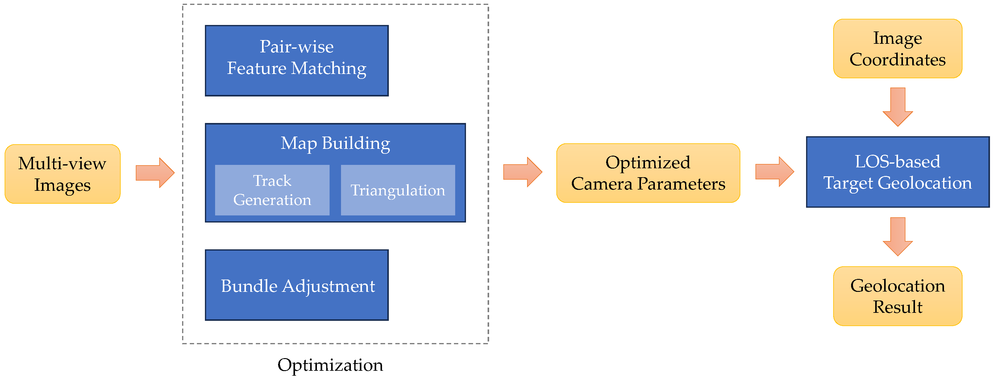
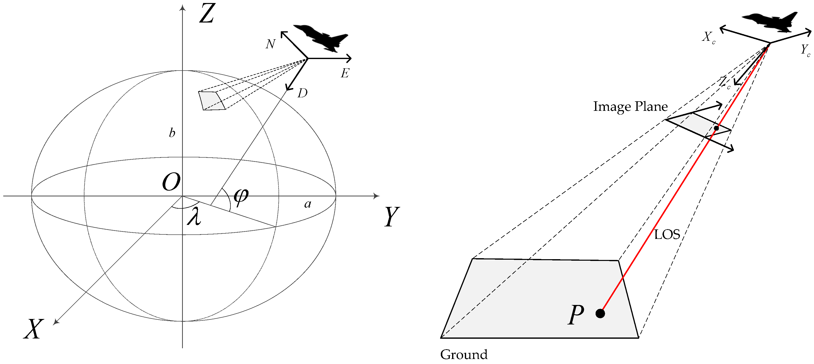


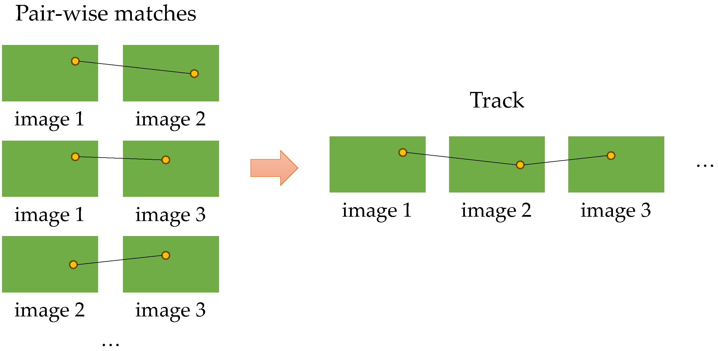


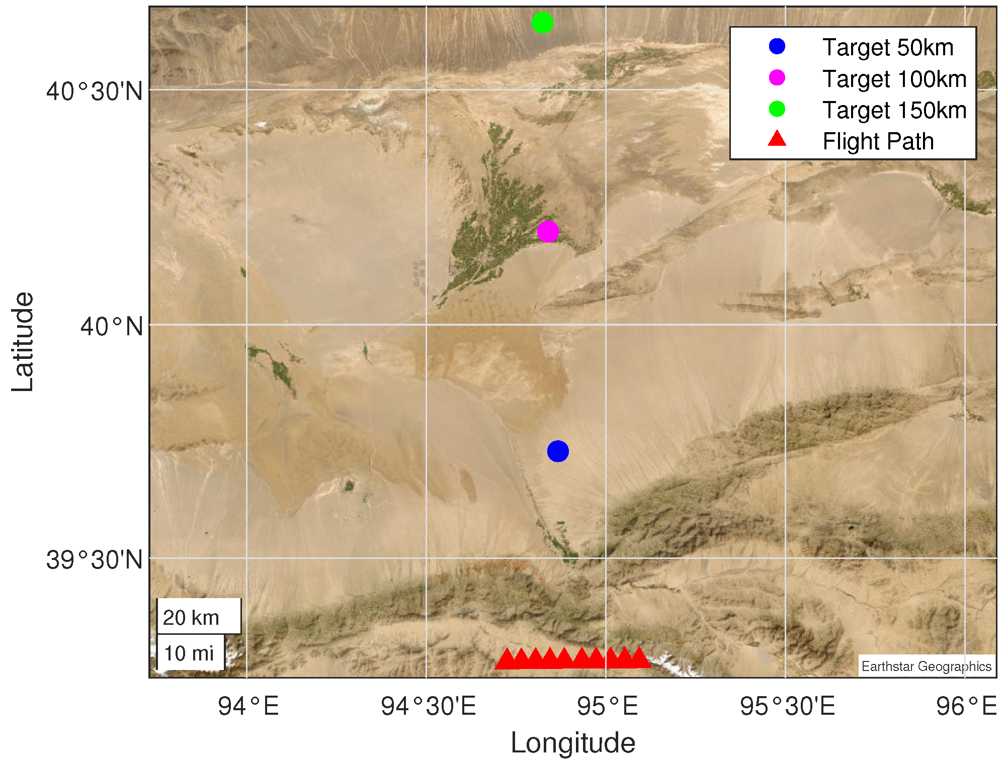



| Data | Unit | Error |
|---|---|---|
| Latitude | ° | 0 |
| Longitude | ° | 0 |
| Altitude | m | 0 |
| Yaw | ″ | 20 |
| Pitch | ″ | 20 |
| Roll | ″ | 20 |
| Gimbal Angle (Outer) | ″ | 3.3 |
| Gimbal Angle (Inner) | ″ | 3.3 |
| Data | Unit | Standard Deviation |
|---|---|---|
| Latitude | ° | 0.0001 |
| Longitude | ° | 0.0001 |
| Altitude | m | 5 |
| Yaw | ° | 0.05 |
| Pitch | ° | 0.01 |
| Roll | ° | 0.01 |
| Gimbal Angle (Outer) | ″ | 10 |
| Gimbal Angle (Inner) | ″ | 10 |
| Slant Range (km) | LOS-Based Method | Our Method Using 10 Images | Our Method Using 30 Images | Our Method Using 50 Images |
|---|---|---|---|---|
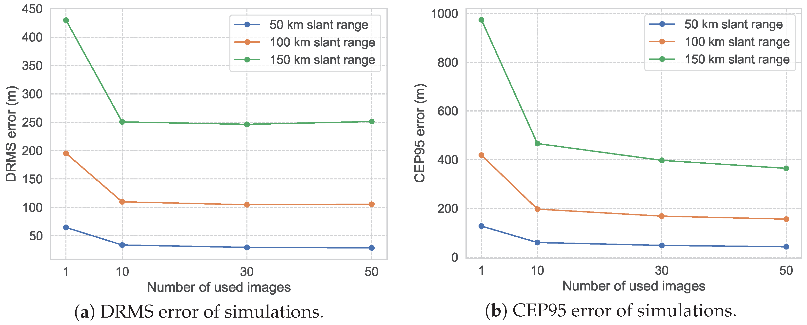
| 50 | 64.49 | 33.61 | 29.38 | 28.59 |
| 100 | 195.31 | 109.73 | 104.56 | 105.44 |
| 150 | 429.94 | 250.65 | 246.33 | 251.29 |
| Slant Range (km) | LOS-Based Method | Our Method Using 10 Images | Our Method Using 30 Images | Our Method Using 50 Images |
|---|---|---|---|---|
| 50 | 127.55 | 60.15 | 48.28 | 42.78 |
| 100 | 418.83 | 197.20 | 168.51 | 156.17 |
| 150 | 973.84 | 466.10 | 397.21 | 364.44 |
Disclaimer/Publisher’s Note: The statements, opinions and data contained in all publications are solely those of the individual author(s) and contributor(s) and not of MDPI and/or the editor(s). MDPI and/or the editor(s) disclaim responsibility for any injury to people or property resulting from any ideas, methods, instructions or products referred to in the content. |
© 2024 by the authors. Licensee MDPI, Basel, Switzerland. This article is an open access article distributed under the terms and conditions of the Creative Commons Attribution (CC BY) license (https://creativecommons.org/licenses/by/4.0/).
Share and Cite
Liu, C.; Ding, Y.; Zhang, H.; Xiu, J.; Kuang, H. Improving Target Geolocation Accuracy with Multi-View Aerial Images in Long-Range Oblique Photography. Drones 2024, 8, 177. https://doi.org/10.3390/drones8050177
Liu C, Ding Y, Zhang H, Xiu J, Kuang H. Improving Target Geolocation Accuracy with Multi-View Aerial Images in Long-Range Oblique Photography. Drones. 2024; 8(5):177. https://doi.org/10.3390/drones8050177
Chicago/Turabian StyleLiu, Chongyang, Yalin Ding, Hongwen Zhang, Jihong Xiu, and Haipeng Kuang. 2024. "Improving Target Geolocation Accuracy with Multi-View Aerial Images in Long-Range Oblique Photography" Drones 8, no. 5: 177. https://doi.org/10.3390/drones8050177
APA StyleLiu, C., Ding, Y., Zhang, H., Xiu, J., & Kuang, H. (2024). Improving Target Geolocation Accuracy with Multi-View Aerial Images in Long-Range Oblique Photography. Drones, 8(5), 177. https://doi.org/10.3390/drones8050177


