Article

Characterization of Strategic Deconflicting Service Impact on Very Low-Level Airspace Capacity

by
Zhiqiang Liu
,
Jose Luis Munoz-Gamarra
and
Juan José Ramos Gonzalez
*
Technical Innovation Cluster on Aeronautical Management, Universitat Autonoma de Barcelona, 08202 Sabadell, Barcelona, Spain
*
Author to whom correspondence should be addressed.
Drones 2024, 8(9), 426; https://doi.org/10.3390/drones8090426
Submission received: 29 July 2024 / Revised: 18 August 2024 / Accepted: 23 August 2024 / Published: 25 August 2024
(This article belongs to the Special Issue Unmanned Traffic Management Systems)

Abstract

:
European airspace is poised for significant transformation as it prepares to accommodate a new class of unmanned traffic that will reshape the transport of people and goods. Unmanned aerial vehicle traffic will introduce a new level of services, but it remains unclear how safety and operators’ time flexibility in flight planning will impact capacity. This study focuses on the impact of strategic deconflicting services on the capacity of the very low-level airspace, a critical area in the future management of unmanned aerial vehicle traffic. The results validate the assumptions regarding the roles of airspace managers and drone operators through simulation studies; highlight the limitations of the first come, first served policy; and propose a batch policy as a potential optimization strategy for future airspace capacity management. The forecasting model developed using regression techniques provides a general method for predicting airspace capacity under specific conditions, contributing to the safe and efficient integration of unmanned aerial vehicles into European airspace.

1. Introduction

An entirely new category of airspace users is on the rise (UAV, unmanned aerial vehicles), pressing to gain access to European airspace to bring a new level of services for transporting people and goods all around the world. An industry, like Air Transportation Management (ATM), in which safety culture is its raison d’être will have to accommodate new kinds of traffic, performance levels, and missions to maintain its safety standards. How can these new aircraft be introduced safely? The answers require a new future airspace management system for Unmanned Traffic Management (UTM) called U-space [1], based on a set of highly automated services that ensure the safe and efficient use of the very low-level (VLL) airspace.
One key service that will support UAV operators in the preparation of their mission will be the strategic conflict resolution service, responsible for maintaining safety by keeping air traffic well separated while ensuring expedition and efficiency. Separation minima are the minimum distance an aircraft (A/C) must keep from other A/Cs to ensure safe execution of the flight. Note that when increasing the separation minima, higher values of safety are obtained at the expense of reducing the capacity of the airspace (number of simultaneous missions that can be executed safely).
U-space strategic deconflicting tools have already proven their capacity to reduce safety events in simulation studies [2] and in real operational conditions through different very large demonstration projects (VLDs) [3]. However, further studies are needed on their impact on system capacity (number of missions cancelled/accepted to ensure safe operations) and the requirements that it will impose in operator–U-space manager timeframe interactions [3]. That is, it meets the requirements of a Reasonable Time to Act (RTTA) [4]. RTTA is the cornerstone of dynamic capacity management and conflict resolution within U-space, designating a predetermined time point before the activation of unmanned aircraft plans. It is used to finalize demand and adjust plans to match airspace capacity. RTTA ensures that adjustments to unmanned aircraft plans are made based on traffic demand at the moment of capacity balancing, aligning them with available airspace capacity. This process enhances the flexibility and efficiency of airspace management while safeguarding safety and operational integrity [3,4].
The main objective of this work is to evaluate how the planning timeline will impact the effective airspace capacity for a given predefined airspace structure. In particular, the time parameters of the strategic conflict resolution procedure, which determine the interaction between the UAV operator and the separation management service during the mission planning phase, will be analyzed by means of realistic simulation. This paper is organized as follows: The second section offers a comprehensive introduction to the essential concepts associated with U-space strategic planning and deconflicting services. The third section delineates the simulation’s objectives, along with the pertinent setup and scenarios. A thorough discussion of the presentation and analysis of the simulation results, as well as the problem’s hypothesis, is provided in the fourth section. The last section concludes this paper and suggests directions for future research.

2. U-Space Strategic Planning and Deconflicting Services

In this section, three important concepts are introduced. Firstly, the airspace manager (AM) and the drone operator (DO), as airspace users, have two key roles in U-space operations. The subsequent research and observations are mainly based on the perspectives of these two roles. Secondly, the “Conflict in the U-space Context” section describes the concept and scenarios of conflict in U-space, helping readers understand what conflict is, why it should be avoided, and the methods proposed to avoid conflict. Thirdly, the Strategic Planning and Deconfliction Services based on take-off time shift is described in detail. The purpose is to reduce or eliminate conflicts by adjusting the take-off time of flight missions.

2.1. Airspace Manager and Drone Operator

U-space [5] was born as a framework to ensure the creation of a safe, efficient, and secure VLL airspace, accommodating a very large variety of new aircrafts: unmanned aerial vehicles (UAVs). It is composed of a set of new services and specific procedures designed to support access to airspace. These new services are provided by U-space service providers (USSPs). A scenario in which more than one USSP provides services in the same volume under the coordination of a Common Information Service Provider [6] (CISP) could be possible. CISP is a centralized platform that facilitates the sharing of essential data among DOs and AMs, supporting safe and efficient UAV operations.
DOs will be able to select the USSP whose services best support them in planning and executing a new mission according to their own interests. On the other side, AMs will be in charge of defining the potential airspace structure and fixing the separation minima values to ensure the creation of safe airspaces. At the same time, they will also fix the time constraint interaction with the operators to submit a mission plan, inform them about a new mission, and potentially notifying them about the approval state.

2.2. Conflict in the U-Space Context

The term conflict refers to a situation in which the minimum safe distance between UAVs is compromised. These minimum safe distances are called separation minima [7]. Separation minima are divided into two primary categories: vertical separation minima and horizontal separation minima.
Vertical separation minima refer to the minimum vertical distance that must be maintained between drones to avoid collisions or disruption of flight paths. This type of separation is essential in a layered airspace structure where drones operate at different altitudes.
Horizontal separation minima, on the other hand, represent the minimum lateral distance required between drones flying at the same or similar altitudes. This ensures a safe buffer and contributes to the smooth flow of air traffic.
Note also that the separation minima values are also intrinsically linked to the UAV’s position uncertainty during the execution of the mission.
When these distances fall below specified thresholds, a loss of separation minima occurs, resulting in a potential conflict situation. In U-space, managing and maintaining these separation minima is critical for preventing conflicts and ensuring the safety and efficiency of all drone operations within the airspace.

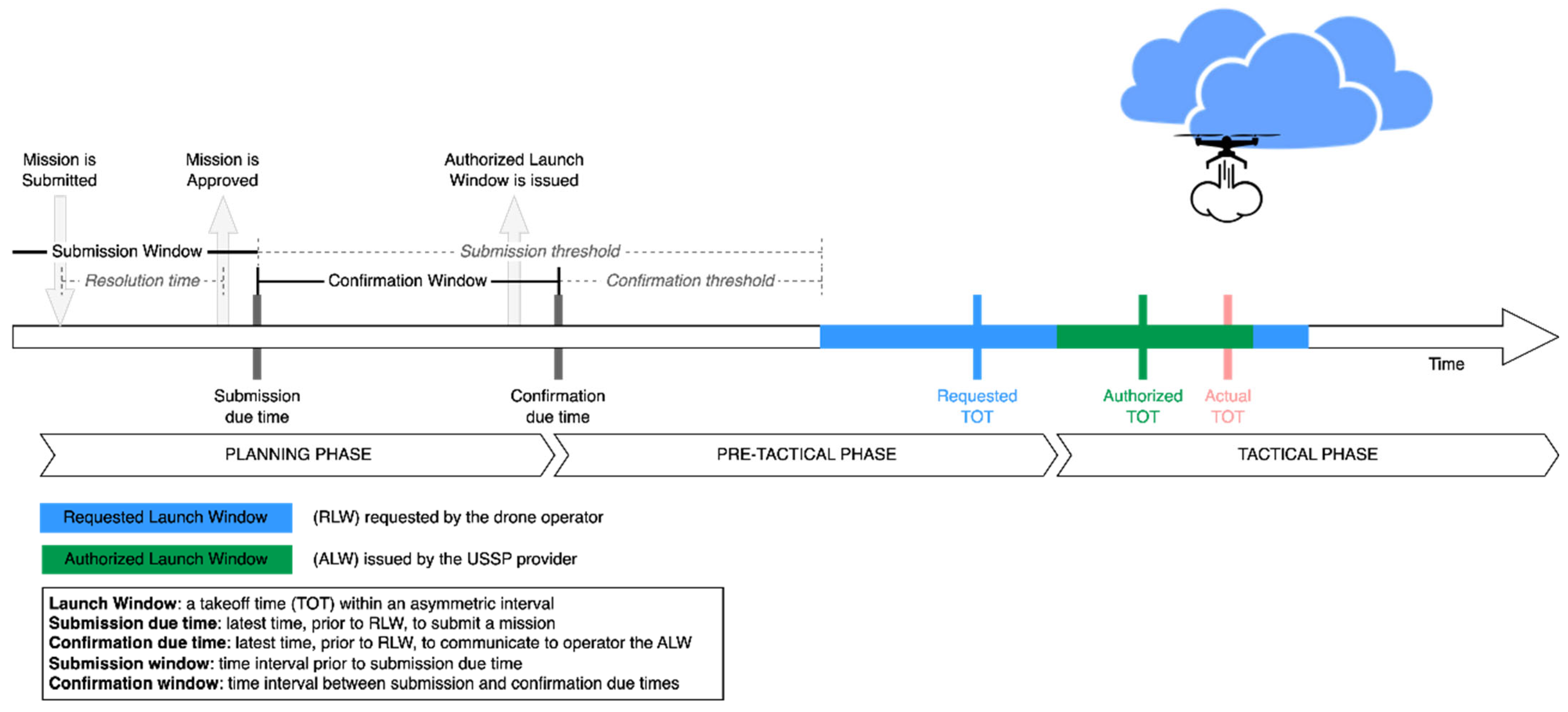
2.3. Strategic Planning and Deconflicting Service

Strategic deconflicting can be considered the “building brick” of safe U-space airspace volumes, lessening the requirements for tactical deconfliction and collision avoidance capabilities. Early attempts to deploy U-space have shown that there are several alternatives for the strategic conflict resolution service [8]. In the state of the art, it can be observed how the main approach relies on changes in the departure time of the FP to ensure high occupancy ratios without impacting the trajectory of the planned mission. Based on a multi-airport coordination management algorithm [9], the EuroDrone [10] project showed a strategic deconfliction tool that maps UAV flight missions, and analyses and detects potential conflicts with other missions, manned aircraft trajectories, and non-flying areas. The detected conflict will be subsequently resolved by means of proposing a departure shift within a pre-defined interval of time [10].
Several approaches have been proposed for strategic deconfliction in UTM, including volume-based deconfliction [11], time-based deconfliction [12], and trajectory-based deconfliction [13], as evidenced in references [14,15,16,17]. Research has systematically assessed the impact of strategic deconfliction on various operational metrics such as efficiency [18], fairness [19], and safety [20,21].
Additionally, investigations into decentralized and first come, first served (FCFS) approaches have analyzed their effects on airspace utilization and mission planning [19]. These studies propose new optimization strategies aimed at enhancing airspace occupancy and reducing flight delays [12,22]. Furthermore, recent advancements have explored the application of batch processing conflict resolution with Multi-Agent Pathfinding methodologies [23,24,25]. This paper specifically focuses on time-based deconfliction strategies within these broader contexts.
Simulations have also been used in conjunction with a variety of UTM services to evaluate the degree to which standards groups’ requirements for strategic deconfliction can facilitate end-to-end safety [26].
Time-based strategic conflict resolution
Strategic planning services carefully develop plans for all submitted missions, and the services play a key role in proactively identifying and resolving potential conflicts in mission planning. The solutions are designed to avoid direct conflicts, with a keen eye for detail in analyzing every single point in every mission’s trajectory and take-off time before departure. This allows for anticipation and mitigation of potential future conflicts, ensuring a smooth and safe operating environment [27].
Central to the approach of strategic planning and deconflicting service is adhering to a FCFS policy. This policy ensures a fair and transparent process, with approval requests being handled in the order in which they are submitted. This approach not only maintains fairness but also streamlines the operational procedures, ensuring effective management for a large number of flight missions without compromising safety or operational efficiency [28].
Essentially, the services work synergistically to create a seamless integration of various plans, balancing the dynamic demands of air traffic with the critical needs of safety and efficiency [29]. The integration is critical to managing the complexity of a predefined airspace, especially in high-density areas where coordinating numerous concurrent flight missions presents unique challenges [30].
The planning phase shown in Figure 1 is structured as follows [31]:
  • A flight plan (FP) request issued by a DO, including the flight trajectory and requested launch window (RLW), which is the time window containing the requested take-off time (RTOT), must be submitted to the strategic conflict resolution service before the established submission due time (SDT), the end of submission window (SW), a requirement applicable to all airspace users.
  • The USSP employs conflict detection and resolution algorithms to identify any potential conflicts and ascertain the availability of at least one authorized launch window (ALW), which sets the safe take-off time interval without conflicts with previously approved FPs.
  • With negligible response delay, the FP is quickly assessed and either approved (if at least one ALW is available) or rejected (if there is no available ALW) before the end of the SW (the SDT). The outcome is then relayed to the DO, with the selected ALW being more concise than the RLW to align with the DO’s preferences.
  • Information about the approved FP’s ALW is withheld from the DO until the confirmation due time (CDT), the end of the confirmation window (CW), also known as the RTTA. This interval allows the USSP to potentially adjust the ALW to accommodate new FP approvals that arrive before the end of the CW (the CDT).
  • Issuance of the ALW to the DO marks the commencement of the pre-tactical phase, setting the stage for the mission’s tactical phase. DOs must adhere to the guidelines and initiate take-off within the designated ALW, ensuring safe airspace without strategic conflicts, which is loss of separation minima with other scheduled FPs.

3. Simulation

In this section, four key aspects are delved into: firstly, the objective of the simulation impact assessment, which elucidates the rationale behind conducting these simulations; secondly, the foundational background of the simulation tools utilized; thirdly, the configuration of the simulation setup, encompassing a description of the simulated environment; and finally, the specific simulation scenarios that are formulated for investigation.

3.1. Purpose of the Simulation Impact Assessment

The simulation experiments aim to achieve the following:
  • Investigate the maximum capacity of the predefined airspace structure.
Airspace capacity is of paramount importance to both airspace managers and drone operators. Understanding the maximum capacity of the existing structure is crucial, with a focus on operational safety and efficiency. Once the airspace structure is in place, the next step is to estimate its full capacity. In this regard, simulation emerges as a vital tool for precise capacity assessment [32].
2.
Verify the impact that each parameter of the strategic deconfliction service has on airspace capacity.
In strategic planning and deconflicting services, the four proposed time windows—submission window, confirmation window, requested launch window and authorized launch window—may have varying impacts on airspace capacity. However, it remains uncertain whether these impacts are positive or negative, and to what extent.
The following question raised is: how can the impact of the differing time windows constraints on performance be verified? Research showed that simulations serve as effective tools for deepening the understanding of the relationship between strategic deconfliction time windows and airspace capacity.
To advance this understanding, a comprehensive simulation approach is proposed. This approach entails the creation of a variety of scenarios reflecting different operational and environmental conditions, enabling the modeling and analysis of the effects of various time window configurations under diverse circumstances. By integrating real-world data and predictive analytics into simulations, more accurate and actionable insights can be generated.
These insights could then inform decision-making processes and lead to the development of more adaptable and efficient airspace management strategies. The ultimate goal of this extended research is not only to understand the current impact of time window variations but also to anticipate future challenges and opportunities in airspace management, ensuring a proactive approach to improve the capacity of complex airspace environments.
3.
Pursue the trade-off for parameters obtained by comparing simulation results.
Before conducting the simulation, the formulated assumption predicts that AMs and DOs might have different expectations regarding the time windows. For instance, AMs might prefer earlier submission and longer confirmation windows, allowing them to receive FP information earlier. This early access to detailed information gives them more time to plan current FPs and more space to move the authorized launch window to accommodate more future FPs, thereby providing better solutions to maximizing airspace utilization. In contrast, DOs might prefer later submission and shorter confirmation windows, to receive responses from the system faster and enable them to complete missions with maximum flexibility.
When it comes to the RLW and ALW, the differences in perspective could be even more significant. AMs may prefer a longer RLW but a shorter ALW. A longer RLW offers more flexibility in scheduling ALWs, while a shorter ALW means a shorter duration of airspace blockage for every single point in the trajectory, allowing the placement of more missions within the same time frame. Conversely, DOs may have the opposite view. They might prefer a shorter RLW and a longer ALW, ideally with the ALW matching the RLW exactly. This minimizes the uncertainty in mission take-off times, which is crucial for DOs or maybe their customers. In this scenario, the primary concern for DOs may not be maximizing airspace utilization but ensuring precise take-offs within required time intervals.
These assumptions, while carefully considered, are subject to verification by means of the analysis of the simulation results. Could the assumption be off the mark? The insights acquired from the simulation will shed light on this question, offering a clearer understanding of the complicated dynamics between time windows and airspace management.
4.
Direct future research based on experimental results.
Exploration transcends the mere determination of maximum capacity, encompassing the identification of capacity enhancement strategies and additional methodologies that facilitate comprehension of airspace capacity limits and enable predictive modeling. The simulation process plays a crucial role in achieving these objectives and may also yield innovative insights.

3.2. Simulation Tools

This research employs the DronAs platform, developed by Aslogic (Aslogic is a spinoff company from Universitat Autònoma de Barcelona, located in Barcelona, Spain), as a key experimental tool. Serving as a fundamental component in the delivery of U-space services, DronAs is equipped with a diverse set of tools specifically designed for developing airspace architecture, including extensive simulation capabilities, real-time data processing features, and interoperability with other systems. The platform has been utilized in VLDs such as CORUS-XUAM [31], EuroDrone, and U-ELCOME [10], demonstrating its effectiveness as both a U-space service platform and an airspace design and analysis tool. The primary focus of this study is to create high-density traffic scenarios and analyze the impact of the time parameters predefined in Table 1.
This tool is instrumental in replicating the strategic planning process of airspace management. It facilitates an in-depth analysis of how to effectively meet operational demands within the parameters of airspace management. Key aspects such as adherence to safety standards, particularly focusing on separation criteria, and the accurate representation of flight trajectories and planning milestones, are integral to this tool’s functionality. This comprehensive approach enables a holistic evaluation of strategic airspace planning, ensuring both safety and efficiency in airspace utilization.

3.3. Simulation Setup

With the aim of simulating high-density airspace scenarios, a synthetic traffic module was built to generate missions that are submitted to the U-space separation management service. The missions generated are a 4D (latitude, longitude, altitude, and time) description of the trajectory to flow. Additionally, the urban airspace configurations were defined in our experimental scenario: corridors (a fixed air route structure between regions are defined, fixing the specific points in the airspace where UAV can fly).
The scenario we simulated draws from the CORUS-XUAM [3] Spanish demonstration conducted in Castelldefels, Barcelona. This demonstration aimed to exhibit the U-space system’s proficiency in handling UAS logistics operations across mid-sized urban and suburban areas within a controlled airspace. The setup included a network of four vertiports, each assigned to a specific drone operator. These operators were responsible for managing their respective drones’ take-offs and landings, undertaking last-mile delivery missions (refer to Figure 2). The vertiports functioned not only as Points of Delivery (PODs) but also as logistic hubs where the drones were equipped with cargo sourced from various transport modes. The operational area of this exercise featured thirteen delivery points, strategically distributed across a span of 3 km.
To ensure the statistical significance of the mean values obtained in the simulation of each scenario/configuration, the separation minima have been fixed to 30 m both horizontally and vertically, taking into account the traffic class; operational environment; and performance of the Communication, Navigation, and Surveillance (CNS) system [33,34]. This fixed value provides pilots with an RTTA in case of a tactical conflict. High-traffic density values (100 FPs per hour) have been used to demonstrate the impact of strategic service parametrization on the acceptance ratio. At lower traffic densities, given the mean flight distance of the missions, the spatial traffic pattern distribution, and the U-space managed volume, the interaction between mission flight plans is limited and does not show the impact of take-off time shifts in distributing traffic temporally. Each instance was run 3000 times with a workload of 1 h of traffic and a traffic density of 100 FPs/hour (as shown in Table 2 below).
In this case, a Monte Carlo simulation method is used to randomly generate traffic sets, including departure and landing points. Therefore, the flight path will also be randomly determined within the predefined structure. The approach allows for a wide variety of realistic traffic scenarios, simulating a wide range of potential operating conditions in U-space. By incorporating this degree of randomness, we aim to closely mimic the unpredictability of real-world flight patterns, thereby increasing the robustness and reliability of the simulation. In this context, the use of Monte Carlo methods is particularly effective for assessing the effectiveness of strategic planning and conflict resolution mechanisms under various airspace conditions.

3.4. Simulation Scenarios

To verify the impact of the four proposed time windows on airspace capacity, we have designed two scenarios, Scenario A and Scenario B, to test the hypotheses. The specific details of Scenario A and Scenario B are outlined in Table 3:
Scenario A is designed to study the impact of the SW and CW within the flight authorization interval on airspace capacity. In this scenario, the RLW and ALW are fixed at 10 min and 1 min, respectively. The information presented in A.1 indicates that FP operation requests must be submitted at least 5 min prior the start of the RLW; a reference for submission due time can be found in Figure 1. Under this premise, the value of the CW increases from 1 to 4, in increments of 1 min; a reference for the confirmation window can also be found in Figure 1. A simulation scenario is created for each combination, and so on for the other configurations. Ideally, by examining the simulation results, the performance of the SW and CW can be observed.
Scenario B focuses on investigating the effects of the RLW and ALW on airspace capacity. For this scenario, the information presented in B.1 indicates that FP operation requests must be submitted at least 30 min prior to the start of the RLW; under this premise, the value of CW is 5 min. The RLW is set from 10 to 60 min in increments of 2 min, and the ALW is 1 min. A simulation scenario is created for each combination, and so on for the other configurations. Ideally, the simulation results will reveal the performance of the RLW and ALW effect on airspace capacity.
By analyzing these two different scenarios, as well as the average acceptance ratio (the percentage of missions accepted relative to those submitted, calculated as Accepted FPs/Submitted FPs), the impact of different time windows on airspace capacity can be observed.

4. Results

In this section, the visualization and comparison of simulation results are presented through a quantitative analysis. This approach examines the effects of various time windows, as introduced in the strategic planning and deconflicting service, on FPs within U-space capacity. A hypothesis has been formulated that could potentially guide future research directions. Furthermore, data obtained from the simulations have informed the development of a forecasting model for predicting airspace capacity.

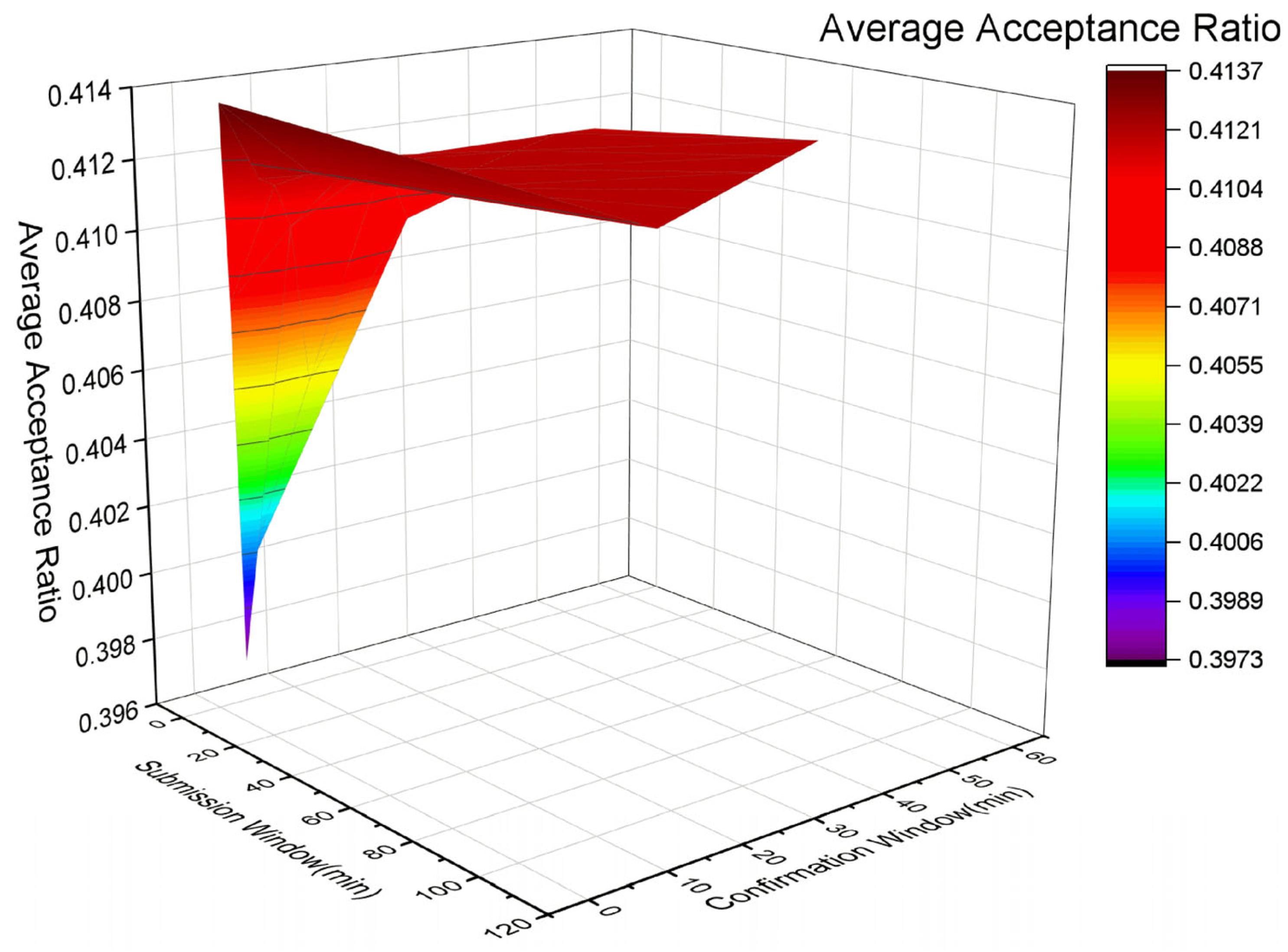
4.1. Submission Window and Confirmation Window

The flight authorization interval includes both the submission window and the confirmation window. So, what impact might these two time windows have on airspace capacity? Or, to put it another way, what expectations might AMs and DOs have regarding these windows? The observation of the results is made based on the following Figure 3.
The data presented in the graph indicate that the average acceptance ratio does not show significant variation with changes in the submission window and confirmation window. With a span from 39.73% to 41.37%, this range is not sufficient to conclude that these two time windows have a significant impact on airspace capacity.
Nonetheless, it would be premature to categorically state that these time windows do not correlate with airspace capacity. Drawing such a definitive conclusion is not warranted by the current data. Therefore, what factors might be contributing to these observed outcomes? The formulated hypotheses in the following sections address this question more scientifically.

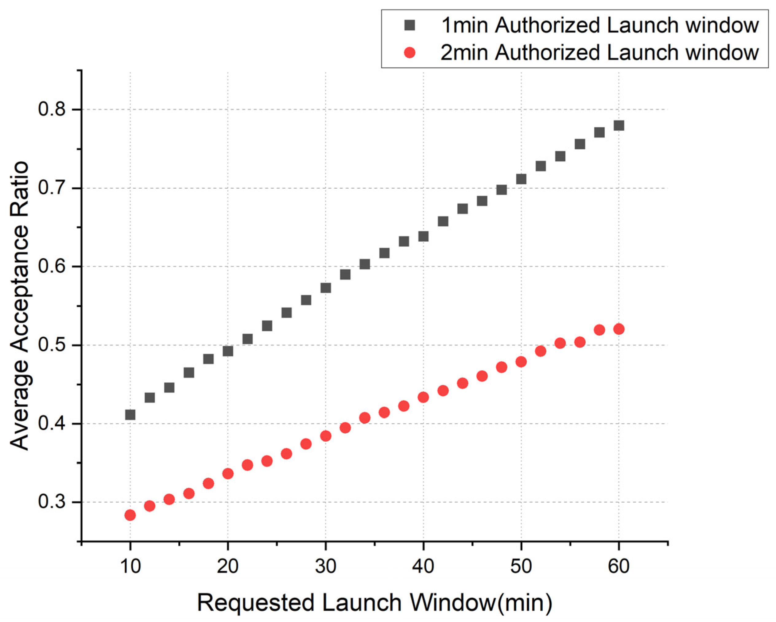
4.2. Requested Launch Window and Authorized Launch Window

Based on Figure 4, it can be seen that the situation with the RLW and ALW is markedly different compared to the submission window and confirmation window.
As the RLW increases, this figure demonstrates a linear increase in the average acceptance ratio for both ALWs. This distinct trend strongly indicates that an expanded RLW positively affects airspace capacity.
In contrast, the ALW presents an inverse correlation. The data reveal that as the ALW lengthens from one minute to two, the average acceptance ratio notably decreases from around 40–80% to almost half, while the duration of the ALW precisely doubles. Further experimental investigations with varied parameters are necessary to establish a more exact relationship. However, the influence of the ALW on airspace capacity is inversely related; when maintaining a steady RLW, a briefer ALW interval is associated with a higher average acceptance ratio. Note that the ALW models the time interval that is booked for the DOs to start their operation. Somehow, the ALW models the flexibility that the system provides operators to start their missions. Any specific time inside this time interval ensures execution of the mission according to the plan. But also, it means an agreed uncertainty buffer that creates latent capacity, and as a consequence, reduces capacity values.

4.3. Hypothesis

Why is it challenging to determine the significant impact of the SW and CW on airspace capacity through the proposed simulations? The hypothesis is associated with the FCFS policy. Due to this policy, the strategic planning and deconflicting service, to some extent, operates “blindly”, which means the algorithm can only process FPs in the order they are submitted, without the ability to predict or “see” future submissions. In this case, the situation involves a stochastic problem [35]. The limitation may lead to the rejection of FPs that could have been accepted with appropriate strategic planning.
To clarify this hypothesis, Figure 5 describes this conjecture. The interactions between different flight missions are spatiotemporal, where Mission A and the other three flight missions, Missions B, C, and D, not only overlap spatially (the flight trajectories of these missions are represented as volumes in Figure 5, indicating that the airspace is blocked during mission execution) but also overlap temporally in various intervals. And, it is obvious that there are no spatiotemporal interactions among Missions B, C, and D.
When considering submitting these four missions to the strategic planning and deconflicting service, once Mission A is approved, regardless of the arrival order of the other three missions, Missions B, C, and D will undoubtedly be rejected by the strategic planning and deconflicting service. This is because the deconflicting algorithm cannot find an available ALW for the other missions within the RLW of Mission A while ensuring that Mission A executes normally. This means that the initially submitted Mission A becomes a constraint on the airspace for other incoming flight missions [12,27]. Under these circumstances, regardless of how far in advance missions are submitted (the length of the SW) or how long its ALW can be adjusted (the length of the CW), once Mission A is approved, the other three will be rejected. Conversely, if any one of Missions B, C, or D is approved, Mission A will also be rejected, and the order of their approval will have no impact.
The FCFS approach does not take into account the future flight trajectories of other FPs, which could likely result in potentially more numbers of acceptable FPs being rejected. In Figure 5’s example, the significant difference in acceptance rates of 25% and 75% is noteworthy. This example also illustrates why the SW and CW have much smaller impacts on airspace capacity compared to the RLW and ALW.
The proposed hypothesis sufficiently elucidates why the timing of task submission (irrespective of changes in the flight authorization interval) has an insignificant impact on enhancing the average acceptance ratio (airspace utilization). Fundamentally, this stems from the strategic planning and deconflicting service’s approach to FP optimization and strategic conflict resolution based on batch processing.

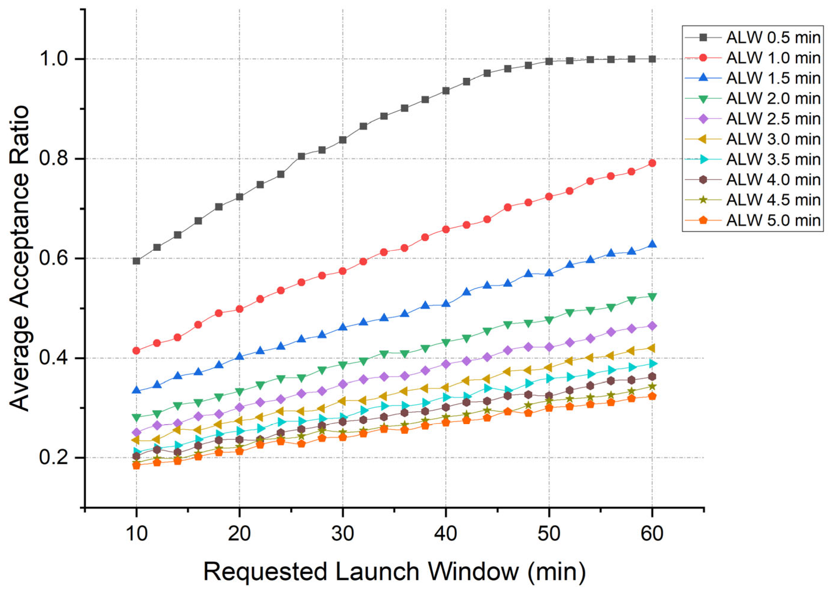
4.4. Further Investigation on RLW and ALW

A preliminary conclusion can be inferred from the results presented in Figure 4: a linear correlation exists between the RLW and the ALW. This observation raises the following question: Can airspace capacity under a specific airspace structure be predicted based on the linear relationship among its various time window parameters? With this query in mind, further research was conducted, and the details of the scenario configuration are illustrated in Table 4. The simulation configuration remains the same as in Table 2.
The purpose of Scenario C is to investigate the linear relationship between the ALW and the RLW under various configurations. Based on these results, linear regression will be employed to develop a forecasting model that predicts airspace capacity within specific airspace structures.
In Table 4, the information presented in C.1–C.10 indicates that FP operation requests must be submitted at least 30 min prior the start of the RLW; under this premise, the value of the CW is 5 min. The RLW is set from 10 to 60 min, in increments of 2 min, and the ALW is set from 0.5 to 5 min in increments of 0.5 min. A simulation scenario is created for each combination, and so on for the other configurations.
Figure 6 illustrates that with a constant RLW, there is a gradual decrease in the average acceptance ratio as the ALW extends. For instance, when the RLW is held constant at 10 min, the average acceptance ratio decreases from approximately 60% to 20% as the ALW extends. Similarly, when the RLW is constant at 60 min, as the ALW extends from 0.5 to 5 min, the average acceptance ratio is decreased from approximately 100% to 30%.
Conversely, with a constant ALW, the average acceptance rate shows a gradual increase in correspondence with an extended RLW. Furthermore, the data suggest a positive linear correlation between the RLW and ALW. An extended RLW means that the strategic conflict resolution service has a longer time interval to shift the mission start to accommodate a higher number of missions planned. On the other hand, the operator is also required to have greater flexibility at the start of their mission, with the aim of ensuring a higher number of missions accepted in each of their interactions.
Based on the simulation data, can a model be constructed to predict airspace capacity within a defined airspace structure? The linear regression analysis of the data, as depicted in Table 5, affirms that such a model is feasible. R square values from 0.9404 to 0.9979 indicate that the forecasting model accounts for over 90% of the variance in the average acceptance ratio. All the P-values are smaller than 0.01, representing RLW’s coefficient as being statistically significant. The formulation distinctly delineates the computational method for forecasting airspace capacity within a designated airspace structure. Given knowledge of the strategic deconflicting time parameters, it becomes straightforward to predict airspace capacity utilizing the pertinent equations.
In Table 5, each regression model is characterized by a specific linear formula, represented as Y = aX + b, where Y denotes the predicted airspace capacity, X correlates directly with the value of the RLW, while a and b are coefficients derived through statistical regression analysis, reflecting the relationship between the RLW and airspace capacity. These predictive models assume fixed values for the SW and the CW—30 min and 5 min, respectively. For example, to predict the airspace capacity when the ALW equals 0.5 min and the RLW is 10 min, the formula Y = 0.0085X + 0.5601 is utilized by substituting X with the RLW value of 10 min. This calculation enables the determination of airspace capacity under these conditions.
Furthermore, by employing the same methodology, it is feasible to extend these investigations to explore the impacts of varying time parameters on airspace capacity. By adjusting variables such as the RLW and ALW in the predictive models, stakeholders can simulate different operational scenarios. This predictive capability facilitates proactive management and optimization of airspace resources, helping to ensure smoother traffic flow and enhanced safety. The strategic conflict resolution and the Dynamic Capacity Balance (DCB) service could use the mathematical formulation of each time configuration (RLW and ALW) to predict the acceptance ratio under a given demand. By monitoring the received demand, the time constraints should be balanced, adjusting the time interval values, to ensure that an established acceptance ratio limit is reached.

5. Conclusions

In this section, the preliminary assumptions concerning the perceptions of AMs and DOs about various time windows in the strategic planning and deconflicting service are rigorously substantiated. Following this, a detailed analysis of the simulation results is conducted, thereby paving the way for a deeper exploration into potential future research directions.

5.1. Airspace Manage/Drone Operator Time Constraints

Based on the simulation results discussed in previous sections, the subsequent conclusions are drawn:
For AMs, it is crucial to maximize airspace utilization while ensuring safety. A longer RLW grants AMs enhanced flexibility in determining the placement of the ALW. Conversely, a shorter ALW reduces the duration of airspace blockage for flight operations. Thus, from the perspective of AMs, a combination of a longer RLW and a shorter ALW is most advantageous.
This advantage is supported by simulation results: a further investigation revealed that the combination of the shortest ALW of 0.5 min with the longest RLW of 60 min yields an average acceptance ratio of nearly 100%. In contrast, the combination of the longest ALW of 5 min with the shortest RLW of 10 min results in the lowest average acceptance ratio, approximately 20%.
Unlike AMs, DOs generally hold a contrasting viewpoint, focusing primarily on their own interests such as expedited conflict resolution, shorter task submission constraint, and ensuring tasks take off on time as per requirements.
As a result, DOs prefer to minimize the RLW to reduce the uncertainty associated with the allocation of the ALW. Conversely, a longer ALW affords DOs enhanced flexibility in scheduling mission take-offs. Therefore, the ideal configuration for DOs entails the shortest possible RLW combined with the longest feasible ALW. This arrangement is most beneficial for DOs when the lengths of these two windows are equivalent.

5.2. Future Work

The inherent constraints of the FCFS policy are, notably, a limitation in compelling the algorithm to methodically plan missions sequentially without accounting for imminent submissions and have led to the development of a batch submission method as a tactical optimization strategy to bolster airspace utilization. The batch submission paradigm, conceptualized as an advanced iteration of FCFS, shifts the algorithm’s emphasis from isolated task submissions to an aggregate batch of tasks. This expanded scope affords the algorithm the capability to “see” or predict an increased array of forthcoming flight missions and reduce the impact of stochastic situations, thereby optimizing the airspace utilization over the specified interval.
The batch method, innovatively designed, directly addresses these limitations by allowing the algorithm to optimize FPs in a more holistic manner. By considering multiple FPs simultaneously, the batch method enhances the algorithm’s ability to manage airspace dynamically, reducing the likelihood of unnecessary FP rejections and improving overall operational efficiency.
Looking ahead, research will concentrate on refining this batch processing strategy and integrating it within a broader airspace management framework. A key area of exploration will involve conducting simulation studies to assess the impact of different batch sizes on airspace occupancy within the specified structure. Understanding how varying batch sizes influence system performance will be crucial for optimizing airspace utilization. The primary aim is to enhance the strategic planning process for FPs, leading to more efficiency and adaptability to fluctuating traffic demands. Ultimately, the success of this approach could lead to the development of more advanced algorithms capable of balancing multiple missions more effectively, thus improving both the capacity and safety of airspace operations.
In further investigations, a forecasting model employing linear regression should be proposed to predict airspace capacity within a specific airspace structure by examining the linear relationship between key time window parameters such as the RLW and the ALW. While the model has shown theoretical soundness and strong statistical significance in simulations, it has yet to be validated in practical operations, which underscores the importance of validation as a crucial next step.
Future research will focus on empirically testing this forecasting model in real-world scenarios, particularly by adjusting strategic deconflicting time windows to evaluate the model’s accuracy in estimating airspace capacity. Additionally, exploring the integration of this model into airspace management practices, such as strategic conflict resolution and DCB services, may lead to significant optimizations in airspace utilization. By dynamically adjusting strategic deconflicting time parameters based on real-time data, the model has potential to enhance the efficiency of airspace management, ensuring smoother traffic flow and better resource allocation.
It is important to recognize that this study is based on a specific corridor architecture within a Spanish urban airspace, and as such, the generalizability of these findings to other airspace configurations or operational environments may be limited. Therefore, future research should critically evaluate whether the results can be applied to different contexts and airspace structures.

Author Contributions

Conceptualization, Z.L., J.L.M.-G. and J.J.R.G.; data curation, Z.L.; writing—original draft preparation, Z.L.; writing—review and editing, J.L.M.-G. and J.J.R.G.; supervision, J.L.M.-G. and J.J.R.G. All authors have read and agreed to the published version of the manuscript.

Funding

This research was funded by MCIN/AEI/10.13039/501100011033, grant number [PID2020-116377RB-C22].

Data Availability Statement

The data presented in this study are available from the corresponding author upon request due to legal reasons.

Acknowledgments

This research is partially supported by the EU Horizon 2020 Research and Innovation Programme, Project “CORUS-XUAM” (Call H2020-SESAR-2019-1, GA: No. 101017682), and the national Spanish project: “A Multi-Agent negotiation framework for planning conflict-free U-space scenarios” (grant PID2020-116377RB-C22 funded by MCIN/AEI/10.13039/501100011033). The opinions expressed in this article reflect only the author’s views.

Conflicts of Interest

The authors declare no conflicts of interest.

References

  1. Barrado, C.; Boyero, M.; Brucculeri, L.; Ferrara, G.; Hately, A.; Hullah, P.; Martin-Marrero, D.; Pastor, E.; Rushton, A.P.; Volkert, A. U-Space Concept of Operations: A Key Enabler for Opening Airspace to Emerging Low-Altitude Operations. Aerospace 2020, 7, 24. [Google Scholar] [CrossRef]
  2. Sachs, P.; Dienes, C.; Dienes, E.; Egorov, M. Effectiveness of Preflight Deconfliction in High-Density Uas Operations. Technical Report Altiscope. 2018. Available online: https://storage.googleapis.com/blueprint/TR-009_Preflight_Deconfliction.pdf (accessed on 12 March 2024).
  3. CORUS-XUAM. ‘Concept of Operations for European U-Space Services—Extension for Urban Air Mobility’, GA 101017682. Available online: https://cordis.europa.eu/project/id/101017682 (accessed on 12 March 2024).
  4. SESAR Joint Undertaking, U-Space Concept of Operations (ConOPs)—Fourth Edition, Publications Office of the European Union. 2023. Available online: https://data.europa.eu/doi/10.2829/207917 (accessed on 12 March 2024).
  5. SESAR Joint Undertaking. European U-Space Blueprint. SESAR. 2019. Available online: https://www.sesarju.eu/sites/default/files/documents/reports/U-space%20Blueprint%20brochure%20final.PDF (accessed on 16 March 2024).
  6. European Union. *Regulation (EU) 2021/664: Establishing a Framework for the U-Space*. Official Journal of the European Union, L 139. 2021. Available online: https://eur-lex.europa.eu/legal-content/EN/TXT/?uri=CELEX%3A32021R0664 (accessed on 18 March 2024).
  7. BUBBLES, ‘Defining the BUilding Basic BLocks for a U-Space SEparation Management Service’, GA 893206. Available online: https://cordis.europa.eu/project/id/893206 (accessed on 18 March 2024).
  8. SESAR JU, ‘Supporting Safe and Secure Drone Operations in Europe: A Report of the Consolidated Sesar U-Space Research and Innovation Results’, SESAR JU, Technical Report. 2020. Available online: https://www.sesarju.eu/sites/default/files/documents/reports/U-space%20research%20innovation%20results.pdf (accessed on 18 March 2024).
  9. Schefers, N.; Carmona, M.A.A.; González, J.J.R.; Nieto, F.S.; Folch, P.; Munoz-Gamarra, J.L. STAM-based methodology to prevent concurrence events in a Multi-Airport System (MAS). Transp. Res. Part C Emerg. Technol. 2020, 110, 186–208. [Google Scholar] [CrossRef]
  10. Lappas, V.; Zoumponos, G.; Kostopoulos, V.; Shin, H.Y.; Tsourdos, A.; Tantarini, M.; Shmoko, D.; Munoz, J.; Amoratis, N.; Maragkakis, A.; et al. EuroDRONE, A European UTM Testbed for U-Space. In Proceedings of the 2020 International Conference on Unmanned Aircraft Systems, ICUAS, Athens, Greece, 1–4 September 2020. [Google Scholar] [CrossRef]
  11. Thompson, E.L.; Xu, Y.; Wei, P. A Framework for Operational Volume Generation for Urban Air Mobility Strategic Deconfliction. In Proceedings of the 2023 International Conference on Unmanned Aircraft Systems, ICUAS, Warsaw, Poland, 6–9 June 2023. [Google Scholar] [CrossRef]
  12. Schefers, N.; González, J.J.R.; Folch, P.; Munoz-Gamarra, J.L. A constraint programming model with time uncertainty for cooperative flight departures. Transp. Res. Part C Emerg. Technol. 2018, 96, 170–191. [Google Scholar] [CrossRef]
  13. Tang, H.; Zhang, Y.; Mohmoodian, V.; Charkhgard, H. Automated flight planning of high-density urban air mobility. Transp. Res. Part C Emerg. Technol. 2021, 131, 103324. [Google Scholar] [CrossRef]
  14. Rodriguez, L.; Balampanis, F.; Cobano, J.A.; Maza, I.; Ollero, A. Wind efficient path planning and reconfiguration of UAS in future ATM. In Proceedings of the 12th USA/Europe Air Traffic Management R and D Seminar, Seattle, WA, USA, 27–30 June 2017. [Google Scholar]
  15. Rios, J.; Aweiss, A.; Jung, J.; Homola, J.; Johnson, M.; Johnson, R. Flight demonstration of unmanned aircraft system (Uas) traffic management (utm) at technical capability level 4. In Proceedings of the AIAA AVIATION 2020 FORUM, Virtual Event, 15–19 June 2020. [Google Scholar] [CrossRef]
  16. Rios, J. Strategic Deconfliction: System Requirements’, NASA UAS Traffic Management (UTM) Project. 2018. Available online: https://www.researchgate.net/profile/Joseph-Rios-3/publication/332107751_UAS_Traffic_Management_UTM_Project_Strategic_Deconfliction_System_Requirements_Final_Report/links/5ca10ced299bf11169547807/UAS-Traffic-Management-UTM-Project-Strategic-Deconfliction-System-Requirements-Final-Report.pdf (accessed on 3 April 2024).
  17. Ribeiro, M.; Ellerbroek, J.; Hoekstra, J. Review of conflict resolution methods for manned and unmanned aviation. Aerospace 2020, 7, 79. [Google Scholar] [CrossRef]
  18. Chin, C.; Gopalakrishnan, K.; Balakrishnan, H.; Egorov, M.; Evans, A. Tradeoffs between Efficiency and Fairness in Unmanned Aircraft Systems Traffic Management. In Proceedings of the 9th International Conference on Research in Air Transportation, Online, 15 September 2020. [Google Scholar]
  19. Evans, A.; Egorov, M.; Munn, S. Fairness in decentralized strategic deconfliction in utm’. In Proceedings of the AIAA Scitech 2020 Forum, Orlando, FL, USA, 6–10 January 2020. [Google Scholar] [CrossRef]
  20. Li, S.; Egorov, M.; Kochenderfer, M.J. Optimizing collision avoidance in dense airspace using deep reinforcement learning. In Proceedings of the 13th USA/Europe Air Traffic Management Research and Development Seminar 2019, Vienna, Austria, 17–21 June 2019. [Google Scholar]
  21. Egorov, M.; Kuroda, V.; Sachs, P. Encounter aware flight planning in the unmanned airspace. In Proceedings of the Integrated Communications, Navigation and Surveillance Conference, ICNS, 2019, Herndon, VA, USA, 9–11 April 2019; 2019. [Google Scholar] [CrossRef]
  22. Tang, Y.; Xu, Y.; Inalhan, G. Incorporating Optimisation in Strategic Conflict Resolution Service in U-space. In Proceedings of the SESAR Innovation Days, Virtual, 7–9 December 2021. [Google Scholar]
  23. Ho, F.; Geraldes, R.; Goncalves, A.; Rigault, B.; Oosedo, A.; Cavazza, M.; Prendinger, H. Pre-Flight Conflict Detection and Resolution for UAV Integration in Shared Airspace: Sendai 2030 Model Case. IEEE Access 2019, 7, 170226–170237. [Google Scholar] [CrossRef]
  24. Groot, J.; Ellerbroek, J.; Hoesktra, J. Enabling Safe and Efficient Separation through Multi-Agent Reinforcement Learning. In Proceedings of the International Conference on Research in Air Transportation (ICRAT), Tampa, FL, USA, 19–23 June 2022. [Google Scholar]
  25. Gigante, G.; Palumbo, R.; Pascarella, D.; Pellegrini, A.; Duca, G.; Piera, M.; Ramos, J. Support to Design for Air Traffic Management: An Approach with Agent-Based Modelling and Evolutionary Search. Int. J. Aviat. Aeronaut. Aerosp. 2021, 8, 1–21. [Google Scholar] [CrossRef]
  26. Egorov, M.; Evans, A.; Campbell, S.; Zanlongo, S.; Young, T. Evaluation of UTM Strategic Deconfliction Through End-to-End Simulation. In Proceedings of the 14th USA/Europe Air Traffic Management Research and Development Seminar, ATM 2021, Virtual, 20–23 September 2021. [Google Scholar]
  27. Schefers, N.; Piera, M.A.; Ramos, J.J.; Nosedal, J. Causal Analysis of Airline Trajectory Preferences to Improve Airspace Capacity. Procedia Comput. Sci. 2016, 104, 321–328. [Google Scholar] [CrossRef]
  28. EASA Opinion No 01/2020: High-Level Regulatory Framework for the U-Space. Available online: https://www.easa.europa.eu/en/document-library/opinions/opinion-012020 (accessed on 18 March 2024).
  29. PARTAKE. cooPerative depArtuRes for a compeTitive ATM networK sErvice. GA 699307. Available online: https://cordis.europa.eu/project/id/699307 (accessed on 18 April 2024).
  30. DACUS, ‘Demand and Capacity Optimisation in U-Space’. GA 893864. Available online: https://cordis.europa.eu/project/id/893864 (accessed on 15 April 2024).
  31. Munoz-Gamarra, J.L.; Ramos, J.J.; Liu, Z.; Sobejano, A. Impact of USSPs performance in shared U-space volumes. In Proceedings of the SESAR Innovation Days, Seville, Spain, 27–30 November 2023. [Google Scholar]
  32. Pellegrini, A.; Di Sanzo, P.; Bevilacqua, B.; Duca, G.; Pascarella, D.; Palumbo, R.; Ramos, J.J.; Piera, M.À.; Gigante, G. Simulation-Based Evolutionary Optimization of Air Traffic Management. IEEE Access 2020, 8, 161551–161570. [Google Scholar] [CrossRef]
  33. Puchol, C.C.; Vélez, N.V.; Tejedor, J.V.B.; Carbó, J.A.V. BUBBLES: A new concept of operations for separation management in the U-space. J. Phys. Conf. Ser. 2023, 2526, 012092. [Google Scholar] [CrossRef]
  34. Rahman, M.F.; Ellerbroek, J.; Hoekstra, J. Effect of CNS Systems Performance on Autonomous Separation in U-Space. In Proceedings of the International Conference on Research in Air Transportation, Singapore, 1–4 July 2024. [Google Scholar]
  35. Soeffker, N.; Ulmer, M.W.; Mattfeld, D.C. Stochastic dynamic vehicle routing in the light of prescriptive analytics: A review. Eur. J. Oper. Res. 2022, 298, 801–820. [Google Scholar] [CrossRef]
Figure 1. Timeline for planning and executing a mission.
Drones 08 00426 g001
Figure 2. Corridor-based airspace structure used in the Spanish demonstrations in the CORUS-XUAM project.
Drones 08 00426 g002
Figure 3. Simulation result of submission window and confirmation window.
Drones 08 00426 g003
Figure 4. Simulation result of requested launch window and authorized launch window.
Drones 08 00426 g004
Figure 5. Example of spatiotemporal interactions between four FPs.
Drones 08 00426 g005
Figure 6. Further investigation on RLW and ALW simulation results.
Drones 08 00426 g006
Table 1. Expectations from drone operator and airspace manager.
Time WindowAirspace ManagerDrone Operator
Submission window (SW)EarlierLater
Confirmation Window (CW)LongerShorter
Requested Launch Window (RLW)LongerShorter
Authorized Launch Window (ALW)ShorterLonger
Table 2. Simulation confirguation.
Simulation Configuration
Demand Density100 FPs/h
Simulation Time1 h
Simulation Repeat3000 times
Airspace ArchitectureCorridor
Horizontal Separation Minima30 m
Vertical Separation Minima30 m
Table 3. Simulation scenarios.
Scenario ConfigurationFlight Authorization Interval
(Minutes Prior to RLW)
RLW (min)ALW (min)
SW (min)CW (min)
Scenario A.151, 2, 3, 4101
Scenario A.2155, 10, 14
Scenario A.3305, 10, 15, …, 29
Scenario A.4605, 10, 15, …, 59
Scenario A.51205, 10, 15, …, 119
Scenario B.130510, 12, 14, …, 601
Scenario B.22
Table 4. Further investigation scenario configuration.
Scenario ConfigurationFlight Authorization Interval
(Minutes Prior to RLW)
RLW (min)ALW (min)
SW (min)CW (min)
Scenario C.130510, 12, 14, …, 600.5
Scenario C.21
Scenario C.31.5
Scenario C.42
Scenario C.52.5
Scenario C.63
Scenario C.73.5
Scenario C.84
Scenario C.94.5
Scenario C.105
Table 5. Linear regression analysis.
RLW (min)ALW (min)R SquareFormulation
0.50.9404Y = 0.0085X + 0.5601
10.9969Y = 0.0075X + 0.3496
101.50.9979Y = 0.0058X + 0.2812
1220.9974Y = 0.0049X + 0.2375
142.50.9967Y = 0.0042X + 0.2155
1630.9971Y = 0.0037X + 0.199
3.50.9958Y = 0.0035X + 0.1809
6040.9927Y = 0.0032X + 0.1737
4.50.9941Y = 0.003X + 0.1634
50.9948Y = 0.0028X + 0.1592
Disclaimer/Publisher’s Note: The statements, opinions and data contained in all publications are solely those of the individual author(s) and contributor(s) and not of MDPI and/or the editor(s). MDPI and/or the editor(s) disclaim responsibility for any injury to people or property resulting from any ideas, methods, instructions or products referred to in the content.

