
Transponder: Support for Localizing Distressed People through a Flying Drone Network


Abstract
1. Introduction
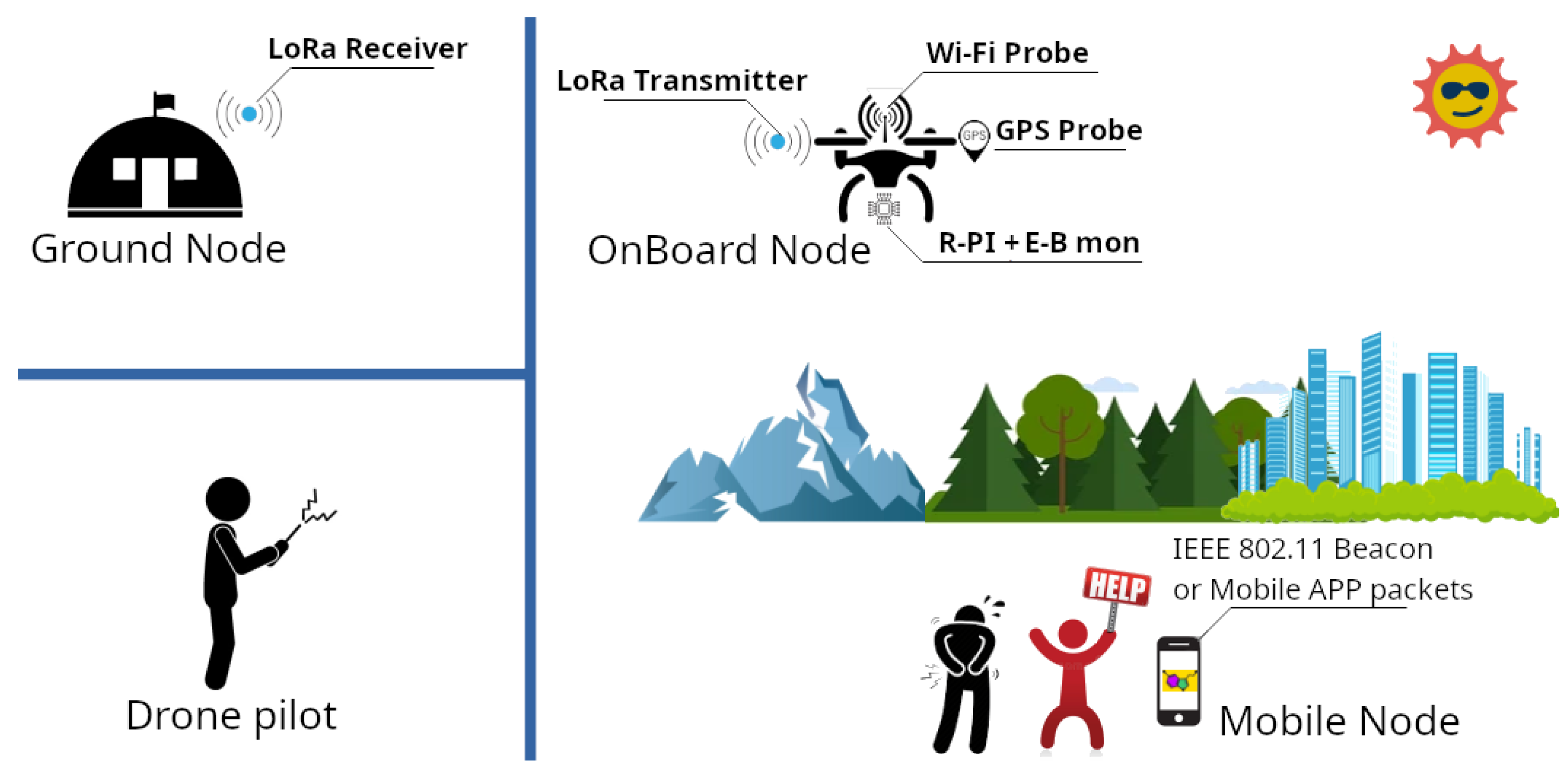
- The Ground Node: This is the node in charge of receiving missing person detection notifications. The Ground node can be a simple LoRa device connected to the smartphone of the rescuer, another device that allows the reception of LoRa messages;
- The Drone Pilot: This node is responsible for configuring the mission from a software perspective and piloting the drone during SAR operations;
- The Mobile Node: This is the mobile device of the missing person, with an active Wi-Fi interface sending Wi-Fi beacons (more details will be provided in the following sections) and possibly using a dedicated mobile application for improving SAR operations;
- The OnBoard Node: This is the prototype in charge of detecting data generated by the device of the missing person and analyzing and sending them to the Ground Node using the LoRa Transmitter.
2. Reseach Questions
- (RQ1) Is increasing the search capacity for missing persons possible?
- (RQ2) Is creating a low-cost, scalable, and easily deployable solution for multiple units possible?
- (RQ3) Is accelerating search and recovery operations possible?
- (RQ4) Is providing first aid information or psychological support to a missing person possible?
3. Background
3.1. Drone-Based Rescue Systems
- (a)
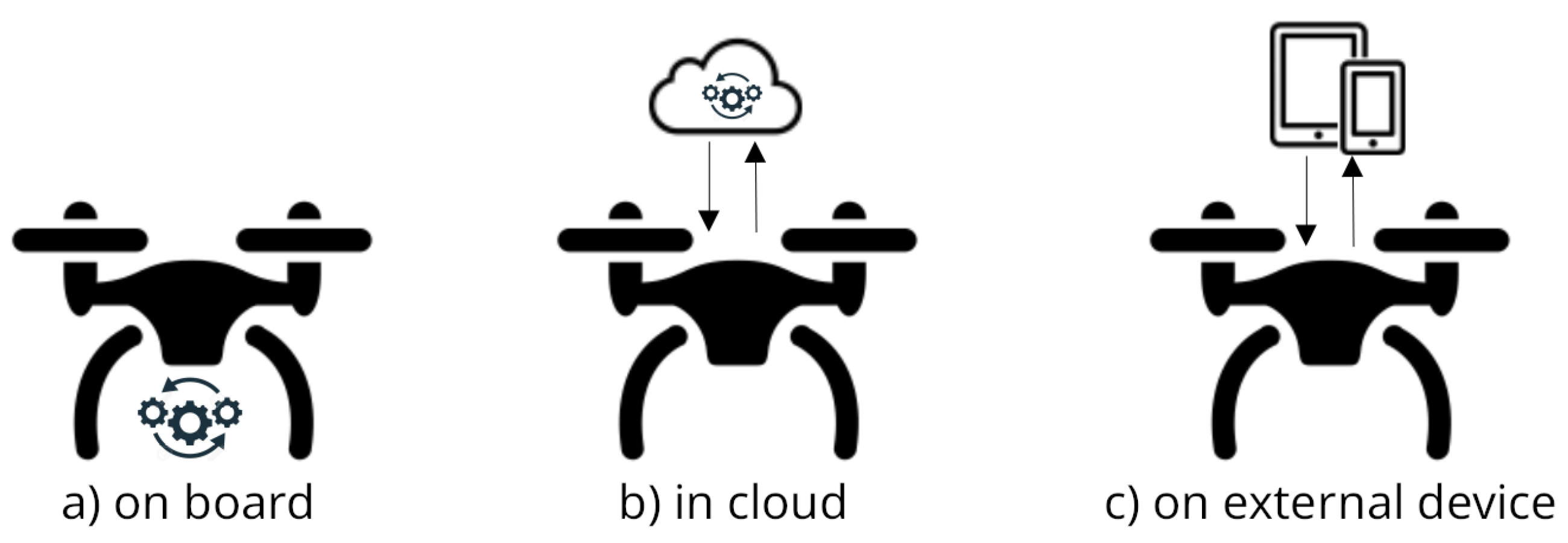
- Placing the data collector and analyzer onboard the drone. In this case, the drone’s data collector and the analyzer can easily solve data transfer and transmission interface issues. However, this solution requires significant computational power for data collection and analysis, often necessitating additional energy sources depending on the analysis and the technology used. Indeed, the drone’s standard computing power could be insufficient to execute high-performance machine-learning algorithms [21]. Using the extra batteries can partially solve the problem but increase the drone’s weight and sometimes compromise the drone’s flight requirements.
- (b)
- Relying on cloud facilities. This could require a suitable and reliable transmission–support connection in the working drone’s area and data transmission to a remote device/component for the analysis computation. However, external servers may compromise the computation, especially in areas with missing GSM/4G/5G coverage. Improvements could be obtained by using satellite connections.
- (c)
- Relying on portable devices such as smartphones or tablets for data analysis. These devices, often the same ones used for drone piloting, could have the same required computational performance as dedicated devices but could have computing power and battery life issues.
3.2. LoRa Technologies
- Experiments for evaluating the performance of LoRa and LoRaWAN networks [22,23,24,25,26,27]. For instance, the work of [28,29] evaluated the scalability in terms of the high guarantee of packet transmission with hundreds of devices connected to the same gateway. The analysis of [30] linked quality and packet loss to the operational conditions of the system, considering transmission power, payload length, and antenna orientation. The evaluation of [31] focused on the relation between energy consumption and the system’s throughput. Finally, the simulations of [32] evaluated how the different spreading factor influences the transmission range of LoRa in approximately 10 km under line-of-sight conditions.
- Application of LP-WAN technologies in IoT domains [33,34,35,36]. The experiments showed that LoRa is generally suitable for large outdoor environments. A wireless monitoring system with reduced throughput can often be used for long-range communication. This is because the transmission delay in LoRa systems, while acceptable, is not considered a fundamental requirement.
- Improvement of LoRaWAN architecture, for instance, integrating specific security and privacy solutions or using the Hardware Secure Module (HSM) for data protection against unauthorized manipulations [37].
- Usage of LoRa technologies for SAR (Search and Rescue) operations. Examples include the following: The proposals of [38], which show how the antenna selection can profoundly affect LoRa signal propagation; Ref. [39], which focus on the energy efficiency of the LoRa-based SAR system; and Ref. [40], which showcases the effectiveness of LoRa communication in catastrophic situations, while [41] proposes a technique based on a LoRa system based on speech recognition in a rescue environment and [42] proposes a hybrid network based on LoRa and ZigBee for SAR operations.
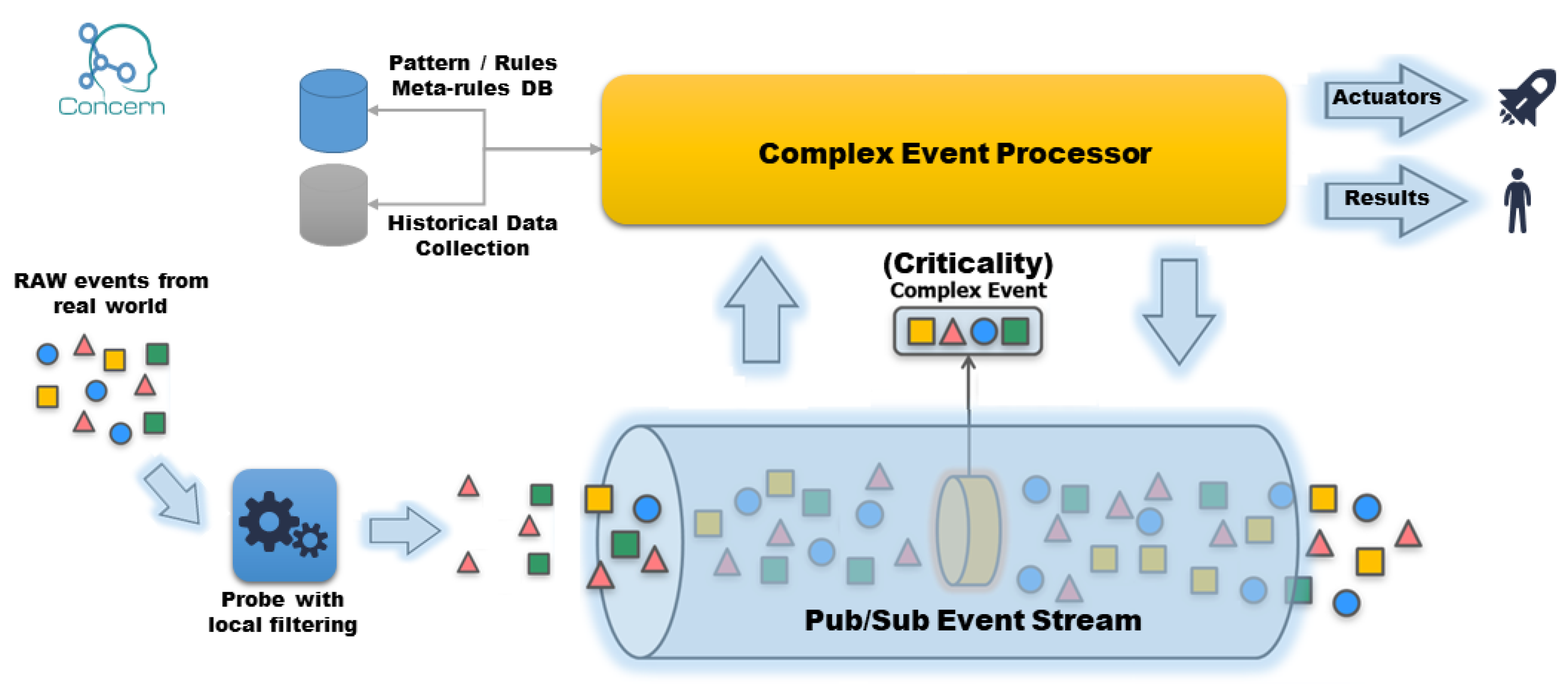
3.3. Event-Based Monitoring System
4. Missing Person Detection Mechanism
| Listing 1. tcpdump execution. |
 |
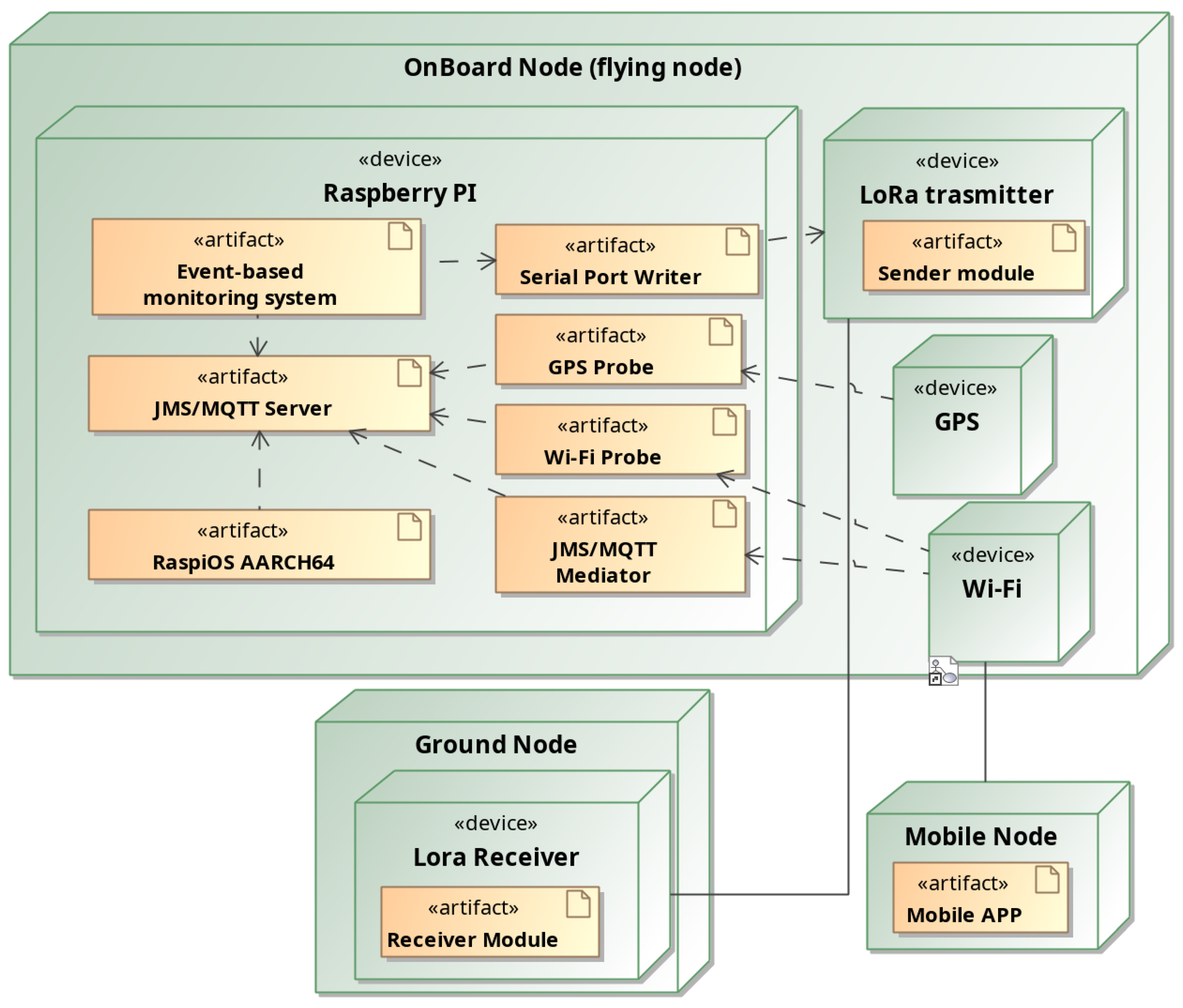
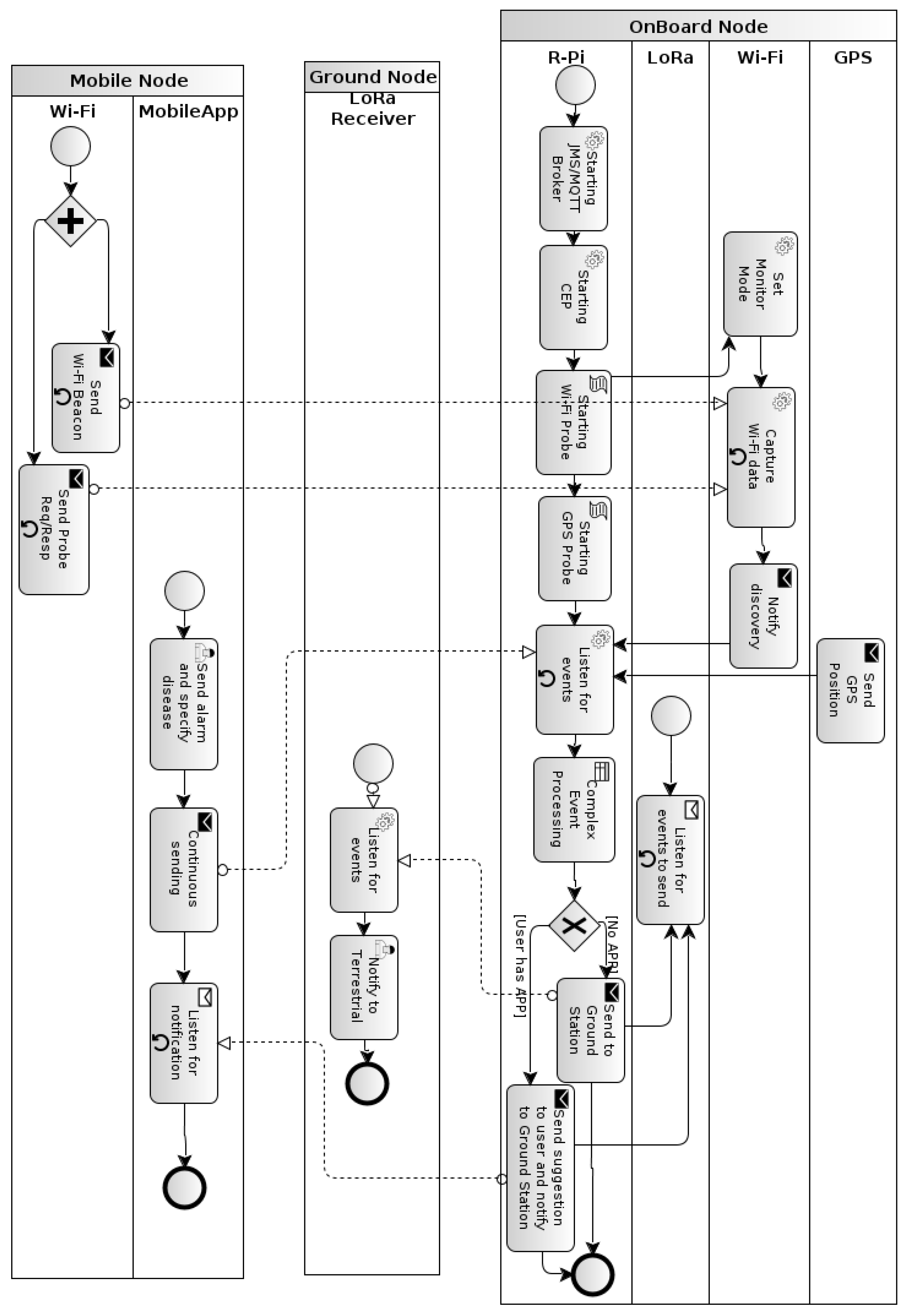
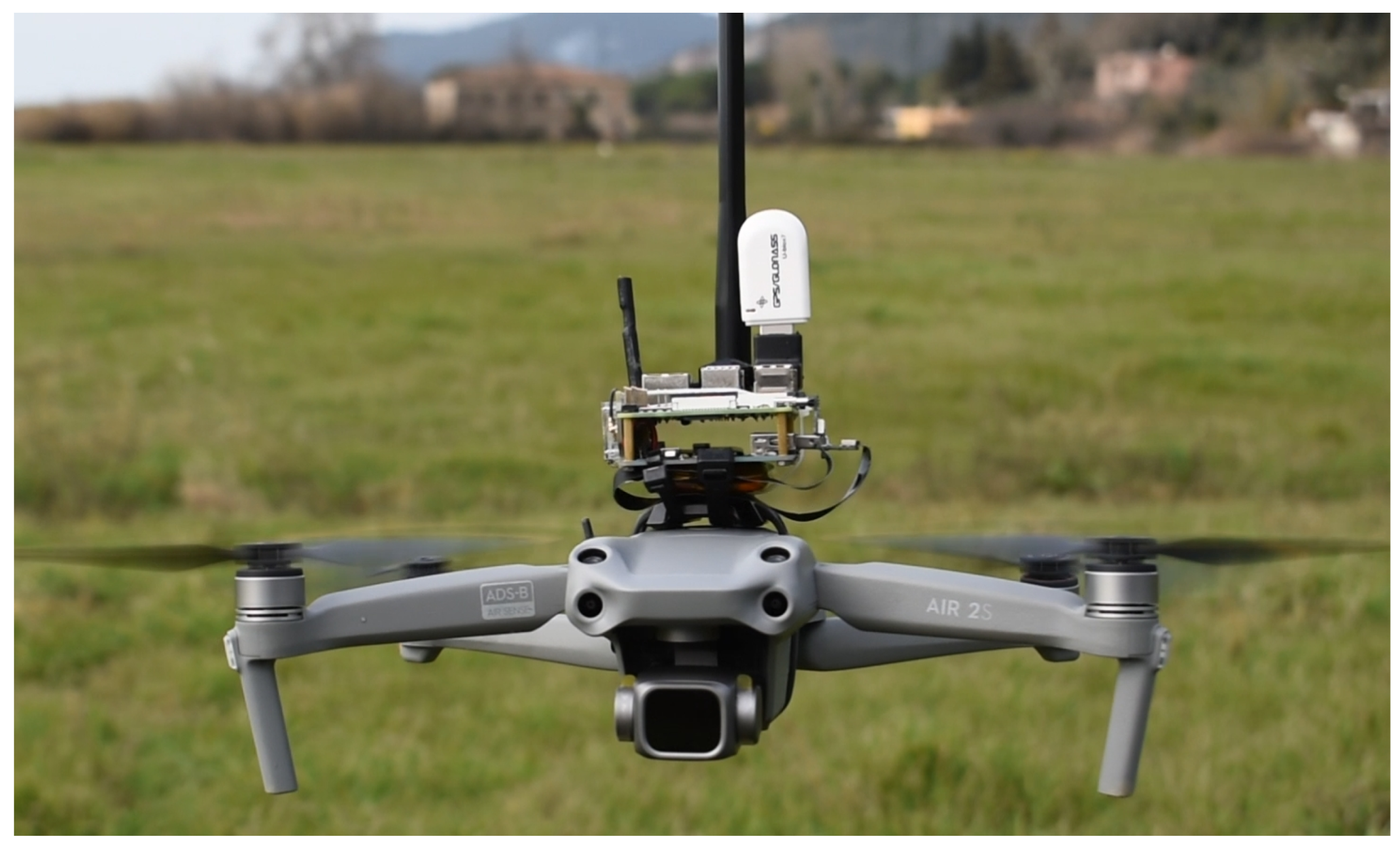
5. Prototype
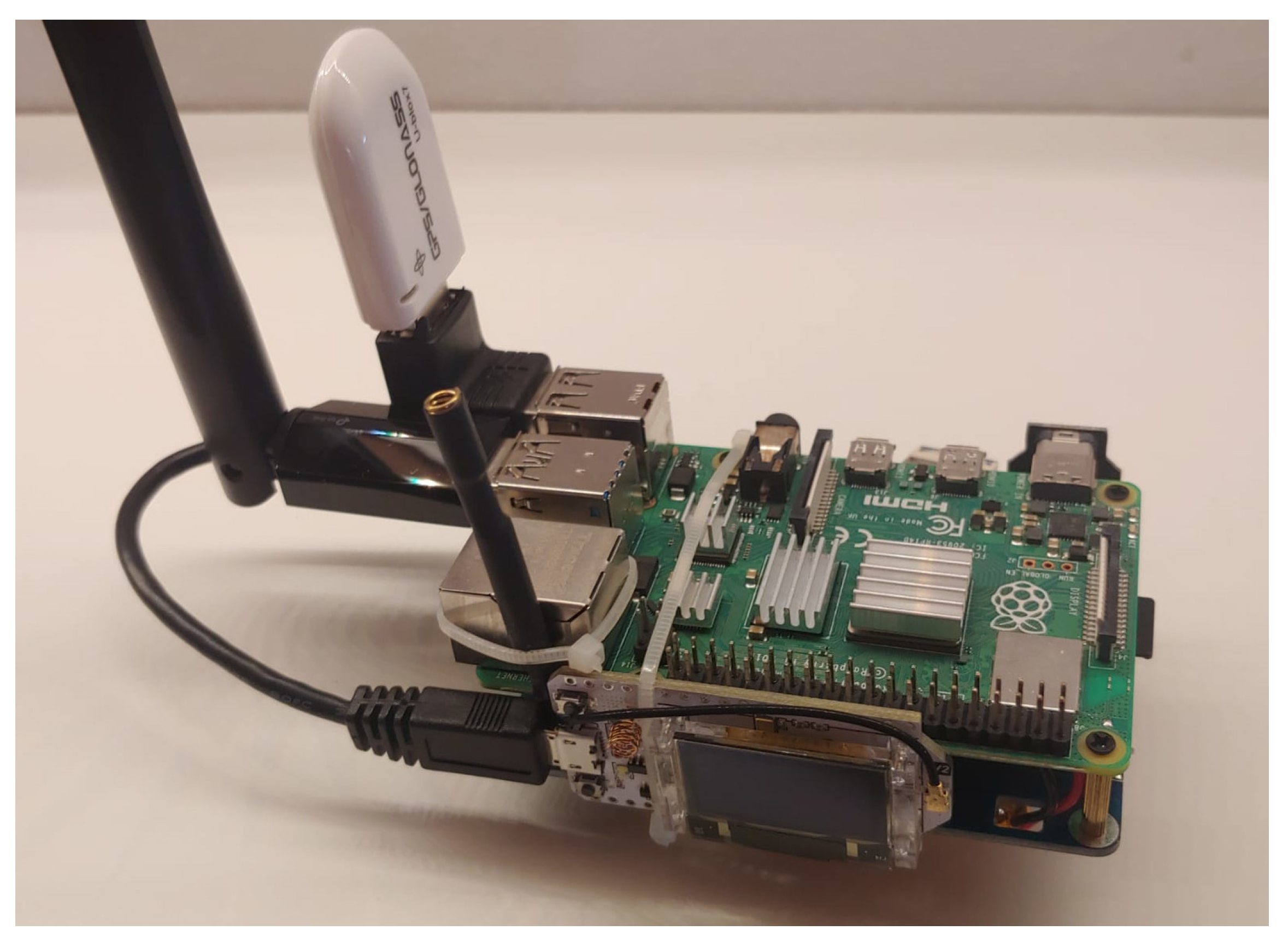
- The primary node, called the OnBoard Node, is the system’s intelligence. It is composed of four interconnected devices, which are a Rasbperry Pi, a LoRa transmitter, a GPS, and a Wi-Fi. The Rasbperry Pi device executes RaspiOS AARCH64 and is the operative system and the component responsible for the monitoring activity. In detail, these are the Event-based monitoring system, Wi-Fi Probe, and GPS Probe. The Rasbperry Pi also includes a Serial Port Writer. More details are provided in Section 5.1.
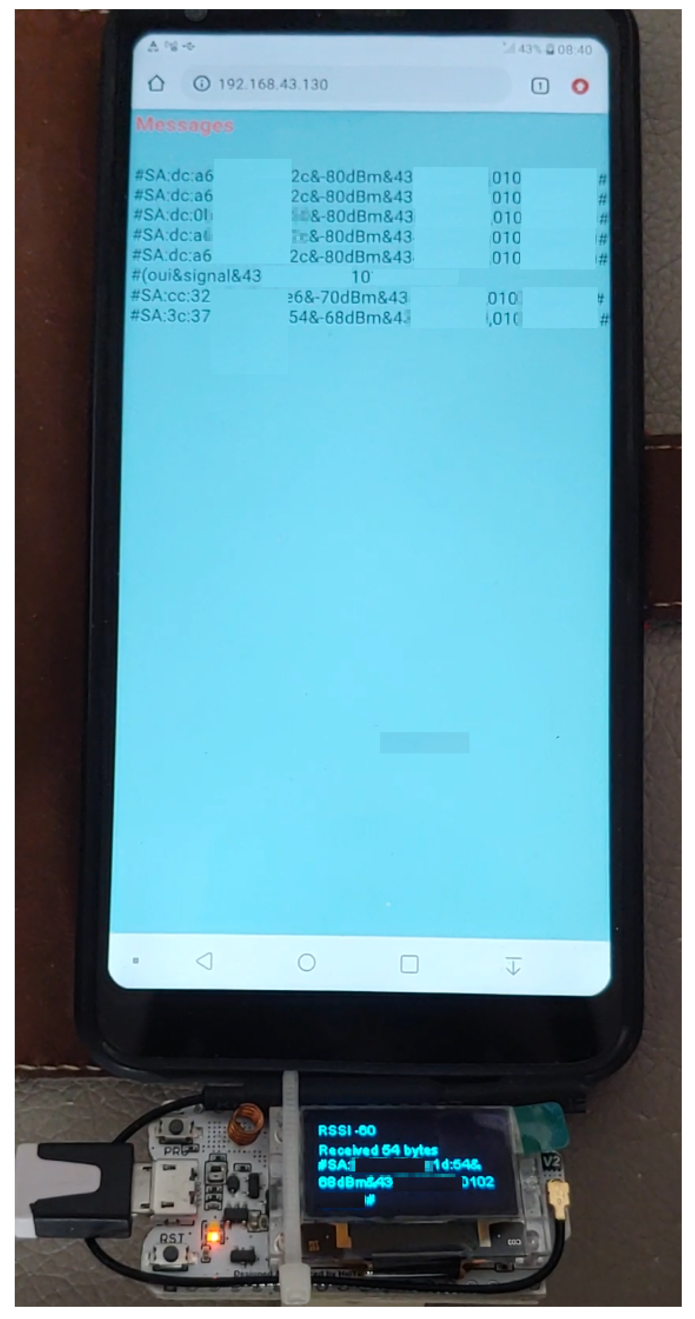
- the Ground Node is the operational base that receives detection notifications by the OnBoard Node. The Ground Node contains a Lora Receiver device managed by the Receiver Module. More details are provided in Section 5.2.
- a Mobile Node is the device owned by the missing person. It is detected by the methodology presented in Section 4. However, as described in Section 5.3, a specific Mobile APP could improve the SAR operation’s success.
5.1. OnBoard Node
- A Raspberry-Pi model 4 Mod B 8 GB;
- A High-gain 2.4/5 GHz Wi-Fi module manageable via USB;
- 2.1.
- Two different antennas have been tested, which provide approximately the same results: TP-Link Archer T3U Plus (https://www.tp-link.com/it/home-networking/adapter/archer-t3u-plus/#specifications, accessed on 28 August 2024) and TP-Link ArcherTX50UH (https://www.tp-link.com/it/home-networking/high-power-adapter/archer-tx50uh/#specifications, accessed on 28 August 2024)
- A USB module for GPS signal detection;
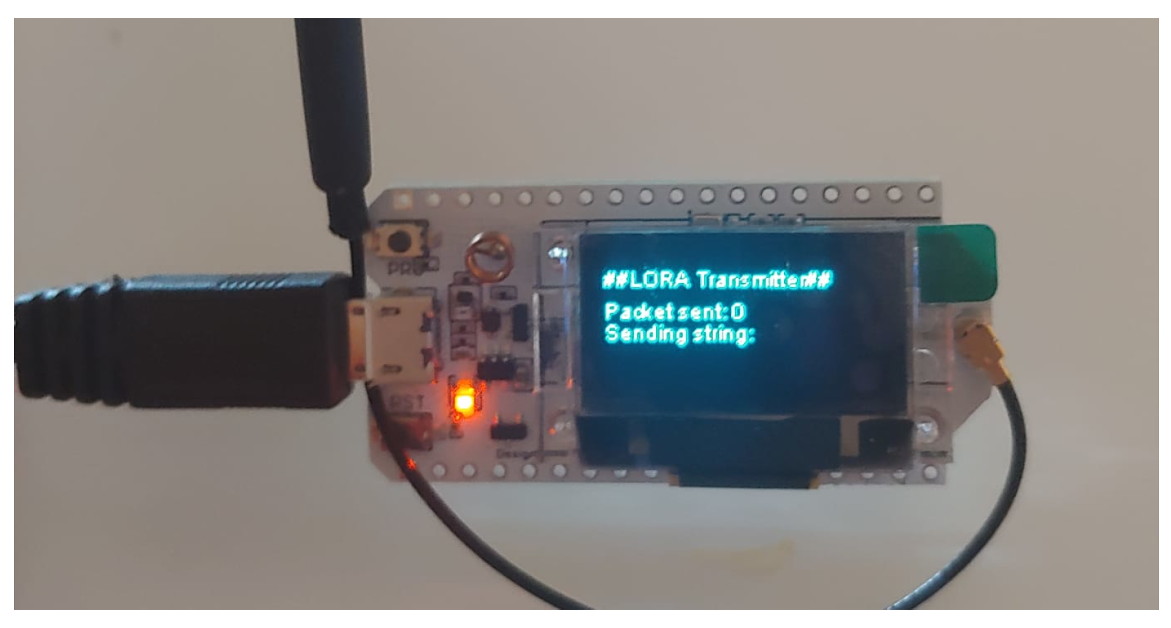
- A LoRa device SX1275 ESP32 with antenna (LoRa Transmitter);
- A battery pack of 3800 mAh or a battery pack of 5000 mAh for 226 g version.
5.1.1. Event-Based Monitoring System
5.1.2. Wi-Fi and GPS Probe
| Listing 2. Single data trace provided by the GPS device. |
 |
5.1.3. JMS/MQTT Server & JMS/MQTT Mediator
5.1.4. LoRa Transmitter
- The begin of the packet is identifiable through a 1-byte Frame Header;
- The type of incident is represented by the Distress ID field (1-byte);
- The number of missing persons is defined by the Involved Person field (1-byte);
- The detection latitude and longitude is represented by the GPS Position field, having a variable length ranging from 17 to 22 bytes depending on the precision or geographic location bytes;
- The end of the packet is identifiable through a 1-byte Frame Tail;
5.2. Ground Node
- manages the received LoRa messages and temporarily stores them;
- can be connected to Wi-Fi networks;
- exposes a web server allowing rescuers to visualize received LoRa messages on a browser.
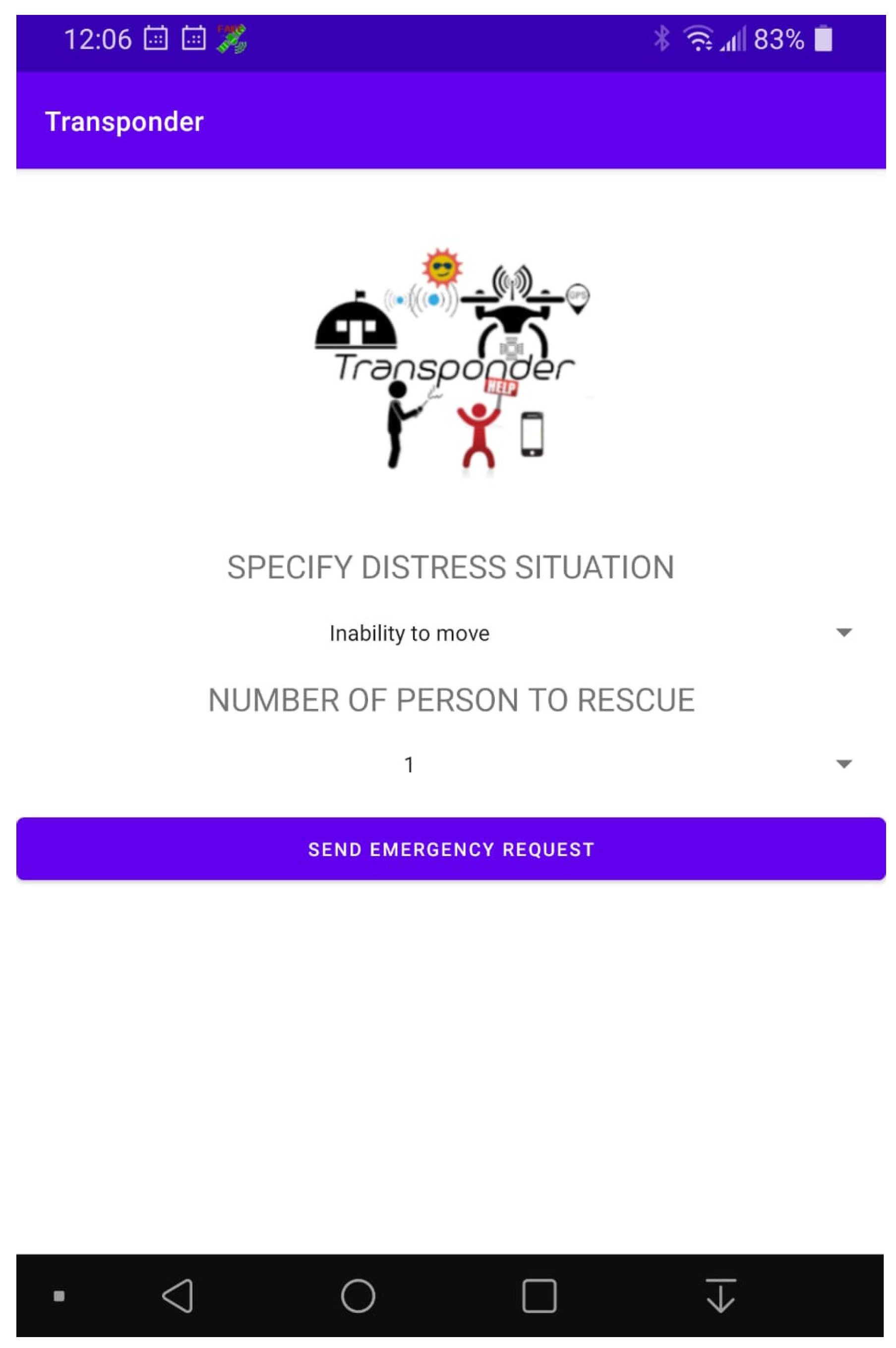
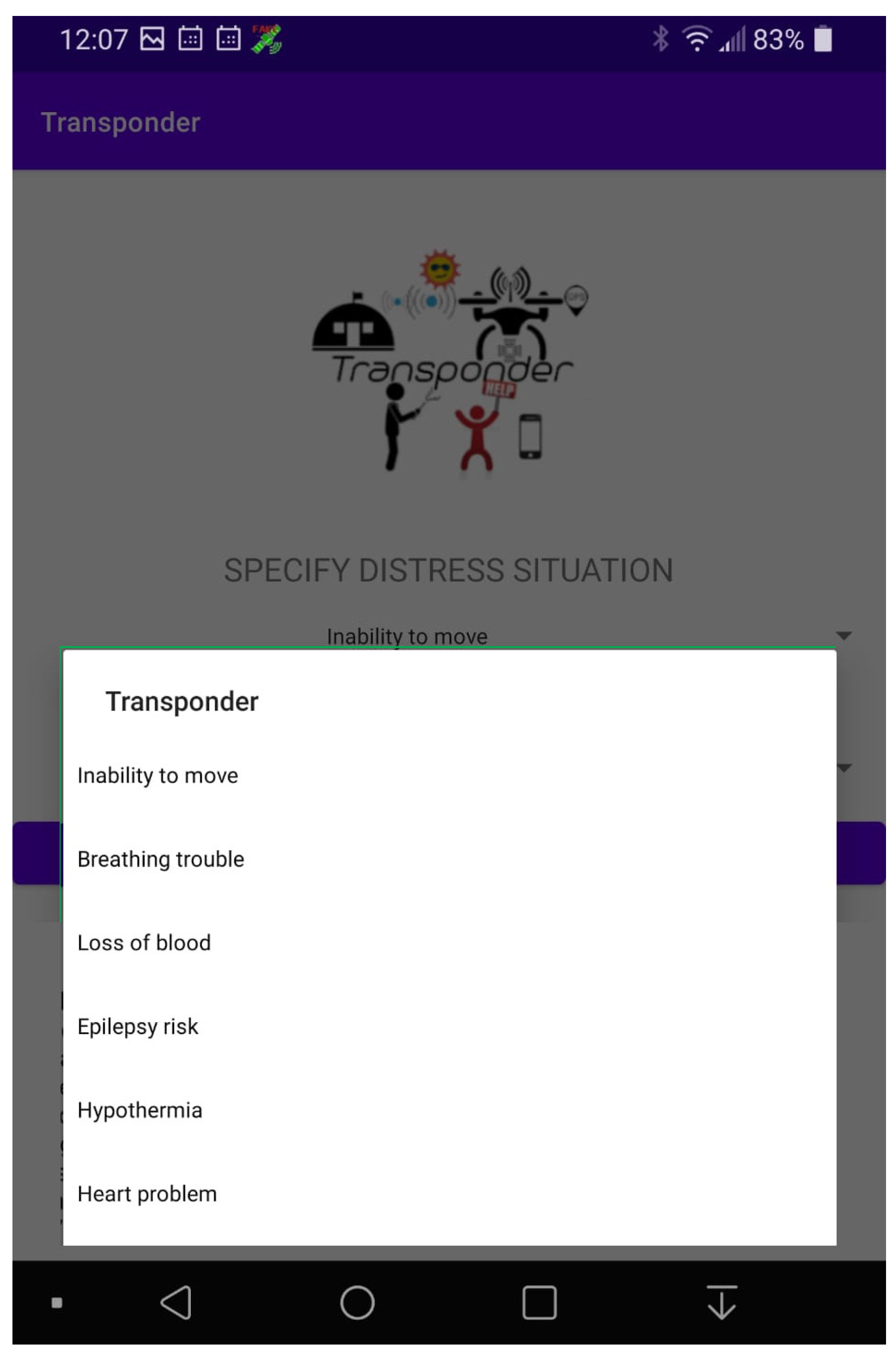
5.3. Mobile Node
6. Scenario Execution
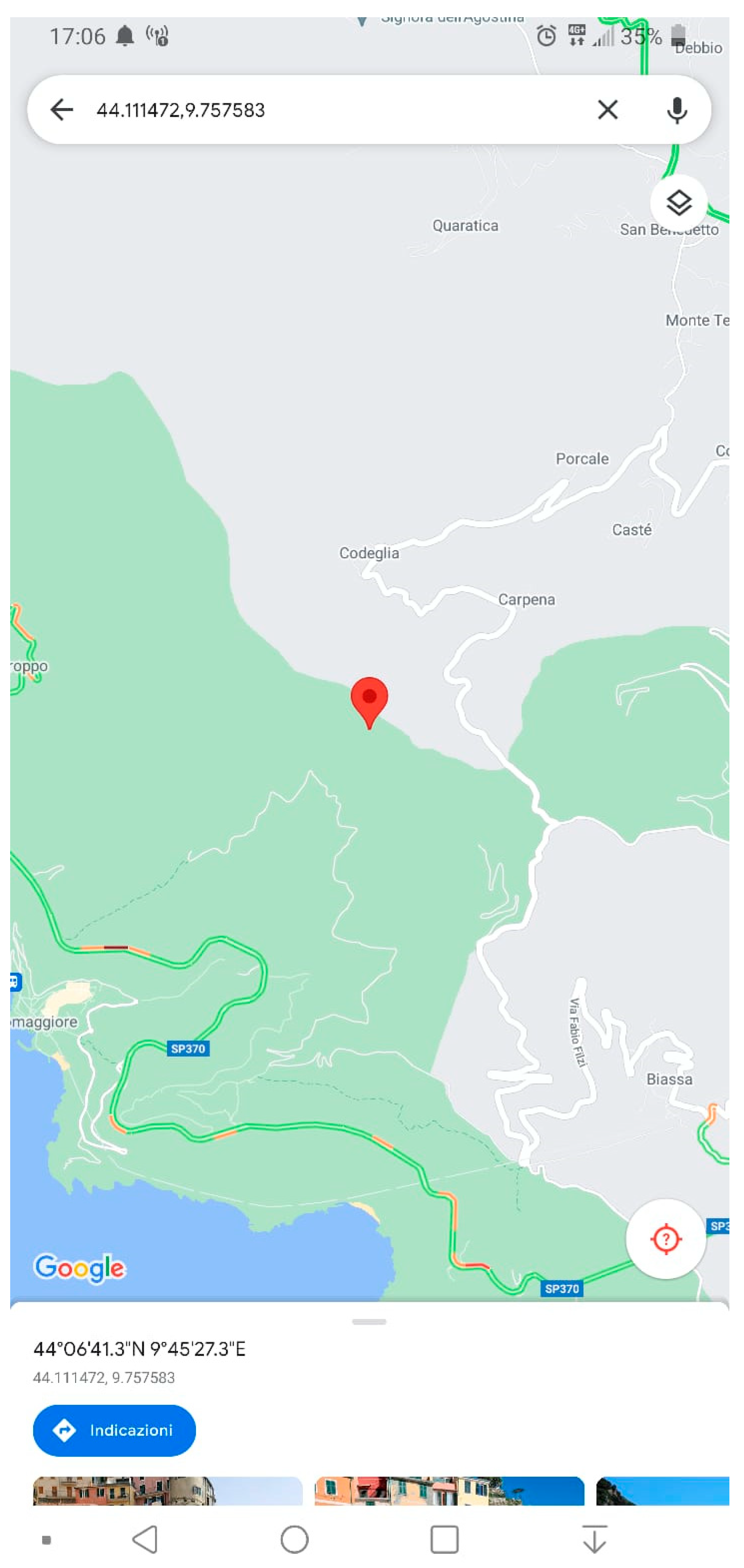
6.1. Localization Capability
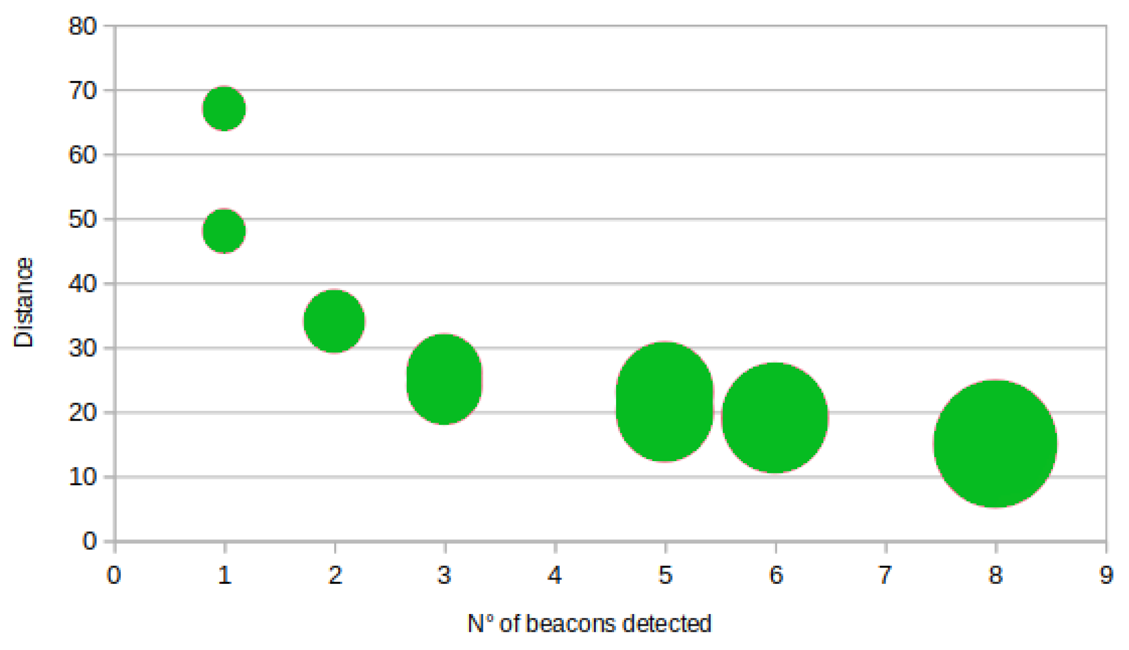
6.2. Maximum Distance of Detection
- Establish the position of the Target Device, maximizing the localization’s precision. In this phase, the Experiment Mobile Position collected by the independent person at the beginning of the experiment has been used;
- Compute the distance between the Target Device position and each detected Beacon position. This calculation has been executed offline by analyzing data captured by the GPS device installed on the OnBoard Node and the information related to the real GPS position of the Target Device computed in step 1;
- Order the computed distances and establish the maximum one. This activity has been executed offline by ordering data by the distance computed in step 2;
- Cluster the detected Beacon positions according to similar distances.
7. Conclusions and Future Works
- Transponder can be an innovative detection mechanism, relying on the capture of Wi-Fi probe requests and beacons, able to effectively identify the presence of mobile devices, even in dense vegetation or areas with limited GPS signals,
- Integrating LoRa technology, Transponder can enhance communication capabilities, ensuring long-range transmission and reliable data exchange in SAR missions.
- The hybrid computational approach—combining onboard processing with ground-based analysis—optimizes the balance between computational power and energy consumption, making the Transponder solution efficient and practical for real-world applications;
- Using inexpensive and lightweight components, Transponder ensures the system’s economic feasibility and ease of deployment.
Author Contributions
Funding
Data Availability Statement
Conflicts of Interest
References
- International Civil Aviation Organization. European search and rescue plan (EUR SAR Plan). In Prepared by the ICAO European and North Atlantic Office on Behalf of the European Aviation System Planning Group (EASPG), 5th ed.; International Civil Aviation Organization: Montréal, QC, USA, 2023. [Google Scholar]
- Ministero_dell’interno. Raccolta di Circolari, Accordi e Protocolli Delle Persone Scomparse; Ministero_dell’interno: Rome, Italy, 2024. [Google Scholar]
- Khan, M.F.; Wang, G.; Bhuiyan, M.Z.A. Towards Debris Information Analysis and Abstraction for Wi-Fi Radar Edge in Collapsed Structures. IEEE Access 2019, 7, 168075–168090. [Google Scholar] [CrossRef]
- Shih, Y.; Pang, A.; Hsiu, P. A Doppler Effect Based Framework for Wi-Fi Signal Tracking in Search and Rescue Operations. IEEE Trans. Veh. Technol. 2018, 67, 3924–3936. [Google Scholar] [CrossRef]
- Elkhaled, Z.; Mcheick, H. Case studies of communications systems during harsh environments: A review of approaches, weaknesses, and limitations to improve quality of service. Int. J. Distrib. Sens. Netw. 2019, 15, 1550147719829960. [Google Scholar] [CrossRef]
- Commissario_Straordinario_del_Governo_per_le_persone_scomparse. Report Primo Semestre 2021; Ministero_dell’interno: Rome, Italy, 2021. [Google Scholar]
- Liu, C.; Szirányi, T. Real-Time Human Detection and Gesture Recognition for On-Board UAV Rescue. Sensors 2021, 21, 2180. [Google Scholar] [CrossRef] [PubMed]
- Martinez-Alpiste, I.; Golcarenarenji, G.; Wang, Q.; Alcaraz-Calero, J.M. Search and rescue operation using UAVs: A case study. Expert Syst. Appl. 2021, 178, 114937. [Google Scholar] [CrossRef]
- Quan, A.; Herrmann, C.; Soliman, H. Project Vulture: A Prototype for Using Drones in Search and Rescue Operations. In Proceedings of the IEEE 15th International Conference on Distributed Computing in Sensor Systems, DCOSS 2019, Santorini, Greece, 29–31 May 2019; pp. 619–624. [Google Scholar] [CrossRef]
- Bozic-Stulic, D.; Marusic, Z.; Gotovac, S. Deep Learning Approach in Aerial Imagery for Supporting Land Search and Rescue Missions. Int. J. Comput. Vis. 2019, 127, 1256–1278. [Google Scholar] [CrossRef]
- Martins, F.; de Groot, M.; Stokkel, X.; Wiering, M.A. Human detection and classification of landing sites for search and rescue drones. In Proceedings of the 24th European Symposium on Artificial Neural Networks, ESANN 2016, Bruges, Belgium, 27–29 April 2016. [Google Scholar]
- Lygouras, E.; Santavas, N.; Taitzoglou, A.; Tarchanidis, K.; Mitropoulos, A.C.; Gasteratos, A. Unsupervised Human Detection with an Embedded Vision System on a Fully Autonomous UAV for Search and Rescue Operations. Sensors 2019, 19, 3542. [Google Scholar] [CrossRef]
- Doherty, P.; Rudol, P. A UAV Search and Rescue Scenario with Human Body Detection and Geolocalization. In Proceedings of the AI 2007: Advances in Artificial Intelligence, 20th Australian Joint Conference on Artificial Intelligence, Gold Coast, Australia, 2–6 December 2007; Proceedings; Lecture Notes in Computer Science. Orgun, M.A., Thornton, J., Eds.; Springer: Berlin/Heidelberg, Germany, 2007; Volume 4830, pp. 1–13. [Google Scholar] [CrossRef]
- Azzollini, I.A.; Mimmo, N.; Gentilini, L.; Marconi, L. UAV-Based Search and Rescue in Avalanches using ARVA: An Extremum Seeking Approach. arXiv 2021, arXiv:2106.14514. [Google Scholar]
- Mimmo, N.; Bernard, P.; Marconi, L. Avalanche Victim Search via Robust Observers. IEEE Trans. Control. Syst. Technol. 2021, 29, 1450–1461. [Google Scholar] [CrossRef]
- Surmann, H.; Kaiser, T.; Leinweber, A.; Senkowski, G.; Slomma, D.; Thurow, M. Small Commercial UAVs for Indoor Search and Rescue Missions. In Proceedings of the 2021 7th International Conference on Automation, Robotics and Applications (ICARA), Prague, Czech Republic, 4–6 February 2021; pp. 106–113. [Google Scholar] [CrossRef]
- Khyavi, M.H. Rescue Network: Using UAVs (drones) in Earthquake Crisis Management. arXiv 2021, arXiv:2105.07172. [Google Scholar]
- Tabasso, C.; Mimmo, N.; Cichella, V.; Marconi, L. Optimal Motion Planning for Localization of Avalanche Victims by Multiple UAVs. IEEE Control. Syst. Lett. 2021, 5, 2054–2059. [Google Scholar] [CrossRef]
- Delafontaine, V.; Schiano, F.; Cocco, G.; Rusu, A.; Floreano, D. Drone-aided Localization in LoRa IoT Networks. In Proceedings of the 2020 IEEE International Conference on Robotics and Automation, ICRA 2020, Paris, France, 31 May–31 August 2020; pp. 286–292. [Google Scholar] [CrossRef]
- Albanese, A.; Sciancalepore, V.; Costa-Pérez, X. SARDO: An Automated Search-and-Rescue Drone-based Solution for Victims Localization. arXiv 2020, arXiv:2003.05819. [Google Scholar] [CrossRef]
- Martinez-Alpiste, I.; Casaseca-de-la-Higuera, P.; Calero, J.M.A.; Grecos, C.; Wang, Q. Benchmarking Machine-Learning-Based Object Detection on a UAV and Mobile Platform. In Proceedings of the 2019 IEEE Wireless Communications and Networking Conference, WCNC 2019, Marrakesh, Morocco, 15–18 April 2019; pp. 1–6. [Google Scholar] [CrossRef]
- Sanchez-Iborra, R.; Sanchez-Gomez, J.; Ballesta-Viñas, J.; Cano, M.; Skarmeta, A.F. Performance Evaluation of LoRa Considering Scenario Conditions. Sensors 2018, 18, 772. [Google Scholar] [CrossRef]
- Ojo, M.O.; Adami, D.; Giordano, S. Experimental Evaluation of a LoRa Wildlife Monitoring Network in a Forest Vegetation Area. Future Internet 2021, 13, 115. [Google Scholar] [CrossRef]
- Cecílio, J.; Ferreira, P.M.; Casimiro, A. Evaluation of LoRa Technology in Flooding Prevention Scenarios. Sensors 2020, 20, 4034. [Google Scholar] [CrossRef]
- Mnguni, S.; Mudali, P.; Abu-Mahfouz, A.M.; Adigun, M. Performance Evaluation of Spreading Factors in LoRa Networks. In Proceedings of the towards New e-Infrastructure and e-Services for Developing Countries, Ebène City, Mauritius, 2–4 December 2020; Zitouni, R., Phokeer, A., Chavula, J., Elmokashfi, A., Gueye, A., Benamar, N., Eds.; Springer International Publishing: Cham, Switzerland, 2021; pp. 203–215. [Google Scholar]
- Tovar-Soto, J.P.; Pareja-Figueredo, C.F.; GarcÃa Navarrete, O.L.; GutiÃMartÃnez, L.C. Performance evaluation of LoRa technology for implementation in rural areas. DYNA 2021, 88, 69–78. [Google Scholar] [CrossRef]
- Sundaram, J.P.S.; Du, W.; Zhao, Z. A Survey on LoRa Networking: Research Problems, Current Solutions, and Open Issues. IEEE Commun. Surv. Tutorials 2020, 22, 371–388. [Google Scholar] [CrossRef]
- Boursianis, A.D.; Papadopoulou, M.S.; Gotsis, A.; Wan, S.; Sarigiannidis, P.; Nikolaidis, S.; Goudos, S.K. Smart Irrigation System for Precision Agriculture—The AREThOU5A IoT Platform. IEEE Sens. J. 2020, 21, 17539–17547. [Google Scholar] [CrossRef]
- Grunwald, A.; Schaarschmidt, M.; Westerkamp, C. LoRaWAN in a rural context: Use cases and opportunities for agricultural businesses. In Proceedings of the Mobile Communication—Technologies and Applications, 24. ITG-Symposium, Osnabrueck, Germany, 15–16 May 2019; pp. 1–6. [Google Scholar]
- Davcev, D.; Mitreski, K.; Trajkovic, S.; Nikolovski, V.; Koteli, N. IoT agriculture system based on LoRaWAN. In Proceedings of the 2018 14th IEEE International Workshop on Factory Communication Systems (WFCS), Imperia, Italy, 13–15 June 2018; pp. 1–4. [Google Scholar] [CrossRef]
- Zhao, W.; Lin, S.; Han, J.; Xu, R.; Hou, L. Design and Implementation of Smart Irrigation System Based on LoRa. In Proceedings of the 2017 IEEE Globecom Workshops (GC Wkshps), Singapore, 4–8 December 2017; pp. 1–6. [Google Scholar] [CrossRef]
- Heble, S.; Kumar, A.; Prasad, K.V.V.D.; Samirana, S.; Rajalakshmi, P.; Desai, U.B. A low power IoT network for smart agriculture. In Proceedings of the 2018 IEEE 4th World Forum on Internet of Things (WF-IoT), Singapore, 5–8 February 2018; pp. 609–614. [Google Scholar] [CrossRef]
- Sanchez-Iborra, R.; Cano, M. State of the Art in LP-WAN Solutions for Industrial IoT Services. Sensors 2016, 16, 708. [Google Scholar] [CrossRef]
- Sanchez-Iborra, R.; Sanchez-Gomez, J.; Skarmeta, A.F. Evolving IoT networks by the confluence of MEC and LP-WAN paradigms. Future Gener. Comput. Syst. 2018, 88, 199–208. [Google Scholar] [CrossRef]
- Anoh, K.O.O.; Bajovic, D.; Ikpehai, A.; Adebisi, B.; Vukobratovic, D. Enabling Peer to Peer Energy Trading in Virtual Microgrids with LP-WAN. In Proceedings of the IEEE EUROCON 2019—18th International Conference on Smart Technologies, Novi Sad, Serbia, 1–4 July 2019; pp. 1–5. [Google Scholar] [CrossRef]
- Mermer, G.B.; Zeydan, E. A comparison of LP-WAN technologies: An overview from a mobile operators’ perspective. In Proceedings of the IEEE 25th Signal Processing and Communications Applications Conference, SIU 2017, Antalya, Turkey, 15–18 May 2017; pp. 1–4. [Google Scholar] [CrossRef]
- Kloibhofer, R.; Kristen, E.; Davoli, L. LoRaWAN with HSM as a Security Improvement for Agriculture Applications. In Proceedings of the Computer Safety, Reliability, and Security. SAFECOMP 2020 Workshops—DECSoS 2020, DepDevOps 2020, USDAI 2020, and WAISE 2020, Lisbon, Portugal, 15 September 2020; Lecture Notes in Computer Science. Casimiro, A., Ortmeier, F., Schoitsch, E., Bitsch, F., Ferreira, P.M., Eds.; Springer: Cham, Switzerland, 2020; Volume 12235, pp. 176–188. [Google Scholar] [CrossRef]
- Iova, O.; Murphy, A.L.; Picco, G.P.; Ghiro, L.; Molteni, D.; Ossi, F.; Cagnacci, F. LoRa from the City to the Mountains: Exploration of Hardware and Environmental Factors. In Proceedings of the Proceedings of the 2017 International Conference on Embedded Wireless Systems and Networks, EWSN 2017, Uppsala, Sweden, 20–22 February 2017; Gunningberg, P., Voigt, T., Mottola, L., Lu, C., Eds.; Junction Publishing: New Westminster, BC, Canada, 2017; pp. 317–322. [Google Scholar]
- Bouras, C.; Gkamas, A.; Salgado, S.A.K. Exploring the energy efficiency for Search and Rescue operations over LoRa. In Proceedings of the 11th IFIP International Conference on New Technologies, Mobility and Security, NTMS 2021, Paris, France, 19–21 April 2021; pp. 1–5. [Google Scholar] [CrossRef]
- Pueyo Centelles, R.; Meseguer, R.; Freitag, F.; Navarro, L.; Ochoa, S.F.; Santos, R.M. LoRaMoto: A communication system to provide safety awareness among civilians after an earthquake. Future Gener. Comput. Syst. 2021, 115, 150–170. [Google Scholar] [CrossRef]
- Jia, L. Design of Lora Communication System Based on Speech Recognition in Emergency Rescue Environment. In Proceedings of the 2nd International Conference on Signal Processing, Computer Networks and Communications, Xiamen, China, 8–10 December 2023; Association for Computing Machinery: New York, NY, USA, 2024. SPCNC ’23. pp. 215–219. [Google Scholar] [CrossRef]
- Bravo-Arrabal, J.; Zambrana, P.; Fernandez-Lozano, J.J.; Gomez-Ruiz, J.A.; Barba, J.S.; García-Cerezo, A. Realistic Deployment of Hybrid Wireless Sensor Networks Based on ZigBee and LoRa for Search and Rescue Applications. IEEE Access 2022, 10, 64618–64637. [Google Scholar] [CrossRef]
- Mansouri-Samani, M.; Sloman, M. Monitoring distributed systems. IEEE Netw. 1993, 7, 20–30. [Google Scholar] [CrossRef]
- Moser, O.; Rosenberg, F.; Dustdar, S. Event Driven Monitoring for Service Composition Infrastructures. In Proceedings of the Web Information Systems Engineering—WISE 2010—11th International Conference, Hong Kong, China, 12–14 December 2010; Lecture Notes in Computer Science. Chen, L., Triantafillou, P., Suel, T., Eds.; Springer: Berlin/Heidelberg, Germany, 2010; Volume 6488, pp. 38–51. [Google Scholar] [CrossRef]
- Barsocchi, P.; Cassarà, P.; Mavilia, F.; Pellegrini, D. Sensing a City’s State of Health: Structural Monitoring System by Internet-of-Things Wireless Sensing Devices. IEEE Consumer Electron. Mag. 2018, 7, 22–31. [Google Scholar] [CrossRef]
- Barcaro, U.; Barsocchi, P.; Crivello, A.; Delmastro, F.; Martino, F.D.; Distefano, E.; Dolciotti, C.; Rosa, D.L.; Magrini, M.; Palumbo, F. INTESA: An Integrated ICT Solution for Promoting Wellbeing in Older People. In Proceedings of the Third Italian Workshop on Artificial Intelligence for Ambient Assisted Living 2017 Co-Located with 16th International Conference of the Italian Association for Artificial Intelligence (AI*IA 2017), Bari, Italy, 16–17 November 2017; CEUR Workshop Proceedings. Bandini, S., Cortellessa, G., Palumbo, F., Eds.; Volume 2061, pp. 102–117. [Google Scholar]
- Dotzer, F.; Fischer, L.; Magiera, P. VARS: A vehicle ad-hoc network reputation system. In Proceedings of the Sixth IEEE International Symposium on a World of Wireless Mobile and Multimedia Networks, Taormina-Giardini Naxos, Italy, 16 June 2005; pp. 454–456. [Google Scholar] [CrossRef]
- Barra, S.; Castiglione, A.; Narducci, F.; Marsico, M.D.; Nappi, M. Biometric data on the edge for secure, smart and user tailored access to cloud services. Future Gener. Comput. Syst. 2019, 101, 534–541. [Google Scholar] [CrossRef]
- Wu, H.; Toti, G.; Morley, K.I.; Ibrahim, Z.M.; Folarin, A.; Jackson, R.G.; Kartoglu, I.; Agrawal, A.; Stringer, C.; Gale, D.; et al. SemEHR: A general-purpose semantic search system to surface semantic data from clinical notes for tailored care, trial recruitment, and clinical research. J. Am. Med. Inform. Assoc. 2018, 25, 530–537. [Google Scholar] [CrossRef] [PubMed]
- Coyle, F.P. Review of ‘The power of events: An introduction to complex event processing in distributed enterprise systems’, by David Luckham, Addison Wesley Professional, May 2002. Ubiquity 2003, 2003, 3. [Google Scholar] [CrossRef]
- Zang, C.; Fan, Y. Complex event processing in enterprise information systems based on RFID. Enterp. Inf. Syst. 2007, 1, 3–23. [Google Scholar] [CrossRef]
- Owens, T.J. Survey of Event Processing; Technical Report; Information 730 Directorate; Air Force Research Laboratory: Greene, OH, USA, 2007. [Google Scholar]
- Hu, X.; Song, L.; Bruggen, D.V.; Striegel, A. Is There WiFi Yet?: How Aggressive Probe Requests Deteriorate Energy and Throughput. In Proceedings of the 2015 ACM Internet Measurement Conference, IMC 2015, Tokyo, Japan, 28–30 October 2015; Cho, K., Fukuda, K., Pai, V.S., Spring, N., Eds.; ACM: New York, NY, USA, 2015; pp. 317–323. [Google Scholar] [CrossRef]
- Prabhu, B.; Chockalingam, A.; Sharma, V. Performance analysis of battery power management schemes in wireless mobile devices. In Proceedings of the 2002 IEEE Wireless Communications and Networking Conference Record, WCNC 2002 (Cat. No.02TH8609), Orlando, FL, USA, 17–21 March 2002; Volume 2, pp. 825–831. [Google Scholar] [CrossRef]
- Freudiger, J. How talkative is your mobile device?: An experimental study of Wi-Fi probe requests. In Proceedings of the 8th ACM Conference on Security & Privacy in Wireless and Mobile Networks, New York, NY, USA, 22–26 June 2015; ACM: New York, NY, USA, 2015; pp. 8:1–8:6. [Google Scholar] [CrossRef]
- IEEE Std 802.11aq-2018 (Amend. IEEE Std 802.11-2016 Amend. By IEEE Std 802.11ai-2016 IEEE Std 802.11ah-2016 IEEE Std 802.11aj-2018 IEEE Std 802.11ak-2018); IEEE Standard for Information Technology–Telecommunications and Information Exchange between Systems Local and Metropolitan area Network–Specific Requirements Part 11: Wireless LAN Medium Access Control (MAC) and Physical Layer (PHY) Specifications Amendment 5: Preassociation Discovery. IEEE: Piscataway, NJ, USA, 2018; pp. 1–69. [CrossRef]
- Cunche, M.; Kâafar, M.A.; Boreli, R. Linking wireless devices using information contained in Wi-Fi probe requests. Pervasive Mob. Comput. 2014, 11, 56–69. [Google Scholar] [CrossRef]
- Musa, A.B.M.; Eriksson, J. Tracking unmodified smartphones using wi-fi monitors. In Proceedings of the 10th ACM Conference on Embedded Network Sensor Systems, SenSys ’12, Toronto, ON, Canada, 6–9 November 2012; Eskicioglu, M.R., Campbell, A., Langendoen, K., Eds.; ACM: New York, NY, USA, 2012; pp. 281–294. [Google Scholar] [CrossRef]
- Cunche, M.; Kâafar, M.A.; Boreli, R. I know who you will meet this evening! Linking wireless devices using Wi-Fi probe requests. In Proceedings of the 2012 IEEE International Symposium on a World of Wireless, Mobile and Multimedia Networks, WoWMoM 2012, San Francisco, CA, USA, 25–28 June 2012; IEEE Computer Society. 2012; pp. 1–9. [Google Scholar] [CrossRef]
- Tang, X.; Xiao, B.; Li, K. Indoor Crowd Density Estimation Through Mobile Smartphone Wi-Fi Probes. IEEE Trans. Syst. Man Cybern. Syst. 2020, 50, 2638–2649. [Google Scholar] [CrossRef]
- Kobayashi, H.; Kinugawa, M.; Suenaga, T.; Chiba, S. Identifiable People Tracking System Using Wi-Fi Probe packet. In Proceedings of the 2020 IEEE International Conference on Consumer Electronics (ICCE), Las Vegas, NV, USA, 4–6 January 2020; pp. 1–2. [Google Scholar] [CrossRef]
- Cheng, N.; Wang, X.O.; Cheng, W.; Mohapatra, P.; Seneviratne, A. Characterizing privacy leakage of public WiFi networks for users on travel. In Proceedings of the IEEE INFOCOM 2013, Turin, Italy, 14–19 April 2013; pp. 2769–2777. [Google Scholar] [CrossRef]
- Calabrò, A.; Marchetti, E. MOTEF: A testing framework for runtime monitoring infrastructures. IEEE Access 2024, 12, 38005–38016. [Google Scholar] [CrossRef]
- Barsocchi, P.; Calabrò, A.; Ferro, E.; Gennaro, C.; Marchetti, E.; Vairo, C. Boosting a Low-Cost Smart Home Environment with Usage and Access Control Rules. Sensors 2018, 18, 1886. [Google Scholar] [CrossRef] [PubMed]


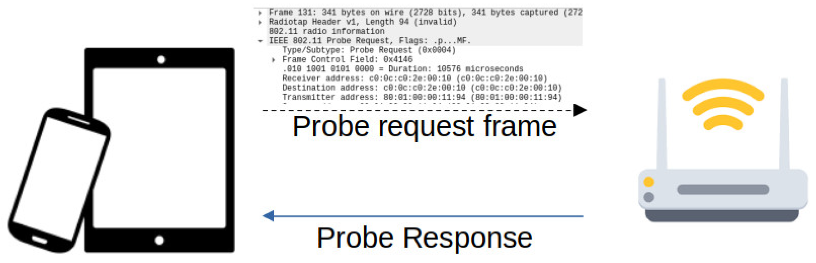
| Frame type | Filter |
|---|---|
| Probe Request | wlan.fc.type_subtype eq 4 |
| Probe response | wlan.fc.type_subtype eq 5 |
| Beacon | wlan.fc.type_subtype eq 8 |
Disclaimer/Publisher’s Note: The statements, opinions and data contained in all publications are solely those of the individual author(s) and contributor(s) and not of MDPI and/or the editor(s). MDPI and/or the editor(s) disclaim responsibility for any injury to people or property resulting from any ideas, methods, instructions or products referred to in the content. |
© 2024 by the authors. Licensee MDPI, Basel, Switzerland. This article is an open access article distributed under the terms and conditions of the Creative Commons Attribution (CC BY) license (https://creativecommons.org/licenses/by/4.0/).
Share and Cite
Calabrò, A.; Marchetti, E. Transponder: Support for Localizing Distressed People through a Flying Drone Network. Drones 2024, 8, 465. https://doi.org/10.3390/drones8090465
Calabrò A, Marchetti E. Transponder: Support for Localizing Distressed People through a Flying Drone Network. Drones. 2024; 8(9):465. https://doi.org/10.3390/drones8090465
Chicago/Turabian StyleCalabrò, Antonello, and Eda Marchetti. 2024. "Transponder: Support for Localizing Distressed People through a Flying Drone Network" Drones 8, no. 9: 465. https://doi.org/10.3390/drones8090465
APA StyleCalabrò, A., & Marchetti, E. (2024). Transponder: Support for Localizing Distressed People through a Flying Drone Network. Drones, 8(9), 465. https://doi.org/10.3390/drones8090465