Article

A Green Laboratory Approach to Medical Sample Transportation: Assessing the Carbon Dioxide (CO2) Footprint of Medical Sample Transportation by Drone, Combustion Car, and Electric Car

1
Faculty of Medical Sciences, Private University of the Principality of Liechtenstein, 9495 Triesen, Liechtenstein
2
Labormedizinisches Zentrum Dr. Risch, 9470 Buchs, Switzerland
3
Institute of Laboratory Medicine and Pathobiochemistry, Molecular Diagnostics, University Hospital Giessen and Marburg, Philipps University Marburg, Baldingerstraße, 35043 Marburg, Germany
4
Centre of Laboratory Medicine, University Institute of Clinical Chemistry, University of Bern, 3010 Bern, Switzerland
*
Author to whom correspondence should be addressed.
Drones 2024, 8(9), 489; https://doi.org/10.3390/drones8090489
Submission received: 22 August 2024 / Revised: 10 September 2024 / Accepted: 13 September 2024 / Published: 14 September 2024

Abstract

:
In response to escalating climate change concerns, this study evaluates the ecological impact and efficiency of medical sample transportation using drones, combustion cars, and electric cars across various terrains and weather conditions in Liechtenstein and Switzerland. Through a comparative analysis, we found that combustion cars emit the highest average CO2 at 159.5 g per kilometer (g/km), while electric cars significantly reduce emissions to an average of 3.43 g/km, representing just 2.15% of the emissions from combustion vehicles. Drones emerged as the most environmentally sustainable option, with an average CO2 emission of 0.09 g/km, which is only 0.07% of combustion car emissions and 2.6% of electric car emissions. Drones also demonstrated superior transport efficiency, covering routes that were, on average, 17% shorter in flat terrain and 24% shorter in mountainous regions compared to cars. Additionally, drones achieved substantial time savings, ranging from 13% to 80% faster delivery times depending on the terrain and traffic conditions. These findings highlight the potential of drone technology to revolutionize healthcare logistics by significantly reducing carbon footprints, optimizing transport routes, and improving delivery efficiency. Integrating drones into healthcare transportation networks offers a promising pathway toward a more sustainable and resilient healthcare system.

1. Introduction

As global climate change intensifies, the healthcare sector faces increasing pressure to adopt sustainable practices, particularly in logistics and transportation. Traditional reliance on combustion vehicles for medical sample transportation contributes significantly to the carbon footprint of healthcare operations, necessitating the urgent reevaluation of these practices [1,2]. Recent technological advancements, including the development of drones and electric vehicles (EVs), offer promising solutions to reduce the environmental impact of healthcare logistics while maintaining operational efficiency [3,4,5].
Several studies have explored the use of drones and EVs in healthcare logistics. For instance, Goodchild and Toy (2018) [6] demonstrated that drones could substantially reduce CO2 emissions in urban logistics, highlighting the ability of drones to navigate efficiently by avoiding road traffic and optimizing delivery routes [6]. Their findings were instrumental in shaping our approach to studying the potential of drones for medical sample transportation, particularly in terms of reducing the environmental impact. Similarly, Rashidzadeh et al. (2021) evaluated the sustainability of drones in the last-mile delivery of medical supplies, emphasizing their capability to reduce greenhouse gas emissions and improve delivery efficiency, particularly in areas with challenging terrains [7,8]. This study informed our comparative approach to analyzing different terrains, such as flat and mountainous regions, in our research. Additionally, research in 2024 has shown that combining drones with trucks can further optimize last-mile delivery systems, both in terms of reducing CO2 emissions and improving delivery times. This hybrid model, which strategically integrates drones and trucks for healthcare logistics, emphasizes the importance of tailoring transportation strategies based on the specific logistical demands of medical sample transport [9,10].
In addition, countries such as Rwanda and Ghana have pioneered the use of drones to deliver medical supplies to remote areas, significantly improving access to essential healthcare services and demonstrating the practical viability of drones in real-world healthcare settings [6,11]. The experiences of these nations were pivotal in the conceptualization of our study, as we aimed to explore how similar methods could be adapted in a European context with varied geographical landscapes [7,12].
Similarly, the integration of electric vehicles into healthcare logistics has been studied in countries like Norway and the Netherlands, where EVs have reduced carbon emissions and operational costs while ensuring the reliable transport of medical samples and supplies [6,13]. Rodrigues et al. (2022) investigated the environmental benefits of EVs, finding that while drones offer the lowest CO2 emissions, EVs remain a highly practical solution in urban areas with robust infrastructure, providing a complementary role in sustainable healthcare logistics [14,15]. This finding aligns with our decision to compare both drones and electric vehicles in our analysis.
While these studies provide valuable insights, there remains a gap in comprehensive comparative analyses of drones, electric vehicles, and traditional combustion cars specifically for medical sample transportation in diverse terrains. Most existing studies focus on isolated factors, such as cost, emissions, or delivery time, without fully exploring the synergies between these transportation modalities. Our research aims to fill this gap by combining field experiments and data analysis to offer empirical evidence on CO2 emissions, transport distances, and delivery times across different geographical landscapes in Liechtenstein and Switzerland.
In conclusion, this study is one of the first to directly compare the environmental and operational impacts of drones, electric vehicles, and combustion cars in the healthcare logistics sector. By leveraging insights from prior studies, we provide a detailed empirical analysis that not only advances our understanding of sustainable logistics solutions but also offers practical guidance for healthcare systems looking to reduce their carbon footprint while enhancing service efficiency.

2. Materials

2.1. Study Design

This research employed a comprehensive study design to evaluate and compare the environmental impact and efficiency of medical sample transportation methods. The study was conducted in two central European countries, the Principality of Liechtenstein and Switzerland, encompassing diverse terrains and weather conditions.
Sample Transportation Routes: Authorized aerial and road routes were utilized to transport medical samples between laboratories in the two countries. These routes were selected to mimic real-world scenarios and to capture the complexities of sample transportation across varying geographical landscapes.

2.2. Transportation Modalities

A range of transportation modalities was evaluated to assess their environmental impact, efficiency, and suitability for medical sample transportation. These modalities include eight types of combustion cars, two types of electric cars, and one hybrid drone. The drone, selected for its maximal efficiency, utilizes glider technology that transitions into hover mode during landing. Table 1 provides a detailed summary of the transportation modalities evaluated in the study.

2.3. Aircraft

Operations were conducted using the Jedsy Glider. The aircraft configuration includes an ADS-B IN transceiver, FLARM, and Remote ID broadcast capabilities. Each aircraft is equipped with a serial number compliant with ANSI/CTA-2063-A-2019, which governs Small Unmanned Aerial Systems Serial Numbers, in accordance with Article 40 (4) of Regulation (EU) 2019/945.
The manufacturer code for Jedsy, assigned by the International Civil Aviation Organization, is 1883. Flight planning tools and flight geography are listed in Table 2, Table 3, Table 4 and Table 5, respectively. Table 2 presents the technical data of the hybrid drone used in this study. The drone, equipped with glider technology for improved efficiency, can transition into hover mode for precise landings. This table outlines key specifications such as flight duration, average altitude, and weather conditions under which the drone was tested. These technical details are essential for understanding the operational efficiency of the drone in medical sample transportation.

2.4. Data Collection

Data collection was conducted under various weather conditions, distances, and terrains, as well as different traffic conditions, to ensure the robustness and reliability of the findings in different real-life circumstances. Energy consumption data were meticulously recorded for each transportation modality, and the CO2 footprint was calculated according to established methodologies endorsed by the Swiss Federal Office for the Environment (FOEN).
Data on consumption and CO2 footprint of combustion cars were collected using car monitoring data from a period over nine months with over 1’632’500 km driven by 54 cars and eight models (Table 1). To assess the ecological impact of electric cars, data were generated by driving transportation routes between laboratories, which totaled over 15,300 km over a period of 6 months. The consumption of the electric car was also monitored by internal consumption monitoring from the car (Table 1).

2.5. System Architecture

This diagram provides an overview of the Flight Termination System (FTS) architecture (Figure 1) and its integration with the main and auxiliary flight controllers (FCs) on an unmanned aerial vehicle (UAV). The illustration details the communication flow between the ground control station, the mobile app, and the FTS device, highlighting the segregation of control between the main FC and the auxiliary FC. The diagram also shows how motor telemetry is relayed back to the main FC and displayed on the ground control station, allowing the Remote Pilot in Command (RPIC) to monitor system performance and verify FTS functionality during pre-flight checks.
The Flight Termination System (FTS) is designed to ensure safe and controlled operation in the event of an emergency or system failure. The functionality is divided into three key sections:
The Flight Termination System (FTS) is a critical safety mechanism designed to ensure the controlled stabilization and landing of the drone in the event of an emergency or system failure. The diagram above illustrates the core components of the FTS, including the relay boards, flight controllers, GPS modules, and communication systems, all of which function together to guarantee the operational safety and reliability of the drone.
The system features two relay boards, each equipped with eight switches. These relay boards are responsible for controlling the drone’s motors (labeled as motors 1-9) and servos (servos 1-6), which manage the propulsion and stabilization of the aircraft. The Electronic Speed Controllers (ESCs), connected to each motor, regulate the motor speed in response to signals from the flight controllers, allowing for precise control of the drone’s movement and altitude. In addition to controlling the propulsion, the servos adjust the drone’s control surfaces to maintain stability and direction during flight.
At the heart of the system are the main Flight Controller (FC) and the auxiliary Flight Controller (FC). The main FC is responsible for primary flight operations, processing inputs from the GPS systems, and sending commands to the motors and servos via the relay boards. The auxiliary FC acts as a backup controller, ensuring redundancy in case of a failure in the main FC. This dual-controller setup enhances the safety and reliability of the drone during critical medical deliveries, especially in unpredictable weather or emergency situations. Both controllers are connected to GPS systems (GPS 1 and GPS 2), which provide real-time location data to the flight controllers for accurate navigation.
The communication module plays an essential role in maintaining connectivity between the ground control station and the drone. Two LTE dongles are used to facilitate communication with the Ground Control Station (GCS) and a mobile application via a mobile network. This allows the remote pilot to monitor the drone’s status and intervene if necessary. The LTE connection ensures continuous data transmission, even in areas with limited coverage, further ensuring the drone can be remotely controlled or brought back safely in case of technical issues.
The FTS device serves as the ultimate safeguard. In case of critical failure, the FTS ensures that the drone’s motors and servos are immediately deactivated, allowing the drone to stabilize and execute a controlled descent. The system is activated either automatically by onboard sensors or manually by the Remote Pilot in Command (RPIC) through the mobile app, ensuring that the drone can land safely, protecting both the cargo and the drone.

2.6. Handling Environmental Challenges in Drone Transportation

Given the sensitivity of drone operations to environmental conditions, specific measures were implemented to ensure the reliability of the study. Drones were tested under a range of weather conditions, including moderate wind, light rain, and varying temperatures, to assess their performance. The drones used were equipped with weather-resistant features, including IP67-rated sealed components and temperature regulation systems like Peltier coolers. To monitor environmental variables in real-time, the drones were outfitted with Bosch BME280 sensors for temperature, humidity, and pressure and LIDAR-Lite v3 sensors for altitude adjustments. Data from these sensors were relayed through a Pixhawk 4 flight controller and transmitted to the ground station using 3DR Telemetry Radio systems, ensuring that environmental conditions were continuously monitored and managed during flights (Table 6).

3. Methods

3.1. CO2 Estimation Methods

This section outlines the core methodology used to estimate the CO2 emissions of the different transportation modalities—drones, electric cars, and combustion cars—within the context of medical sample transportation. Accurate estimation of the carbon footprint is crucial to understanding the environmental impact of each mode of transport, especially given the healthcare sector’s push towards sustainability.
The CO2 estimation for combustion vehicles was based on standard fuel consumption data, reflecting real-world driving conditions observed during our study. Over 1.6 million kilometers were driven by 54 different combustion vehicles across multiple terrains and routes. The emissions were calculated using an emission factor of 2640 g of CO2 per liter of fuel consumed in accordance with guidelines from the Environmental Protection Agency (EPA). This approach ensured that variations in emissions due to differing fuel efficiencies across vehicle models were accounted for, as combustion vehicles are the most variable in terms of emissions output. These calculations were consistently applied across all routes, ensuring that each vehicle’s performance was accurately reflected in the results.
For electric vehicles (EVs), the CO2 emissions were calculated based on energy consumption during transportation. Data were gathered from onboard vehicle systems, with over 15,300 km of driving recorded. This real-time monitoring of electricity usage provided precise energy consumption data. To translate electricity consumption into CO2 emissions, we used the emission factor of 29.8 g of CO2 per kilowatt-hour (kWh), corresponding to the carbon intensity of the electricity grid in Switzerland and Liechtenstein during the study period. This factor takes into account the high reliance on renewable energy sources in the region, which significantly lowers the CO2 emissions of EVs compared to regions with more carbon-intensive grids. Additionally, the variance in energy consumption due to factors like terrain and payload weight was included to ensure an accurate comparison with combustion vehicles and drones.
The CO2 emissions from drones were calculated similarly to the EVs, as drones are powered by electricity. Data on energy consumption during the flight was collected using onboard systems, which continuously monitored power usage in real time. These data were then multiplied by the same electricity emission factor (29.8 g CO2/kWh) to provide an accurate reflection of the carbon emissions associated with drone flights. The hybrid drone used in this study features glider technology, which enhances energy efficiency, especially over longer distances and varied terrain. This operational characteristic allowed drones to reduce their overall energy consumption compared to both EVs and combustion vehicles, particularly in mountainous areas where ground vehicles require more energy for ascent. We selected these calculation methods to ensure consistency and comparability across all transportation modalities. To further validate these methods, we conducted a sensitivity analysis, testing the impact of variations in grid emissions factors (for EVs and drones) and fuel efficiency (for combustion cars) on the results. This provided a robust comparison between transportation methods, reflecting their environmental performance in real-world medical logistics operations.
Moreover, the application of these methods in our study is unique in its focus on healthcare logistics, where speed and operational efficiency are crucial. The CO2 emissions were not only measured per kilometer but also normalized according to payload weight and terrain difficulty, offering a more detailed and realistic assessment of environmental impact in medical sample transportation. By doing so, we have demonstrated how the sustainability of healthcare logistics can be enhanced through the use of drones and EVs, particularly in regions with diverse geographical landscapes like Liechtenstein and Switzerland.

3.2. Routes

The routes for this experiment were chosen so a high variability of different altitudes and terrains could be achieved. This is to say that implementation and CO2 consumption vary highly between different routes and are, therefore, highly individual for every region and country (Table 7 and Table 8).

3.3. Comparative and Statistical Analyses

Comparative analyses were conducted to quantify the environmental impact of each transportation method. Key parameters such as CO2 emissions, transport distances, and delivery times were analyzed to provide insights into the relative sustainability and efficiency of the transportation modalities. The program MedCalc was used to perform the statistical test for significance (paired T-Test) and to visualize the data with box plots. The visualization, apart from the box plots, was performed with Microsoft Excel. For the calculation of the CO2 emission from combustion cars, a 2640 g/L emission was assumed (EPA, United States Environmental Protection Agency). For the CO2 emission from electric cars used both by cars and drones, the estimated CO2 emission per kilo Watt hour (kWh) was 29.8 g (BAG, Federal Office of the Environment FOEN).

3.4. Quality Assurance

Rigorous quality assurance measures were implemented throughout the study to ensure the accuracy and reliability of the data collected. Standard operating procedures (SOPs) were followed for sample collection, transportation, and analysis, and stringent quality control protocols were employed to minimize potential sources of bias and error.

3.5. Ethical Considerations

Ethical considerations were carefully addressed throughout the study to ensure the protection of patient confidentiality and compliance with relevant regulations and guidelines governing medical sample transportation and research involving human subjects. No patient samples were flown by drones since this study only compared the ecological impact and efficiency of drones and different cars.

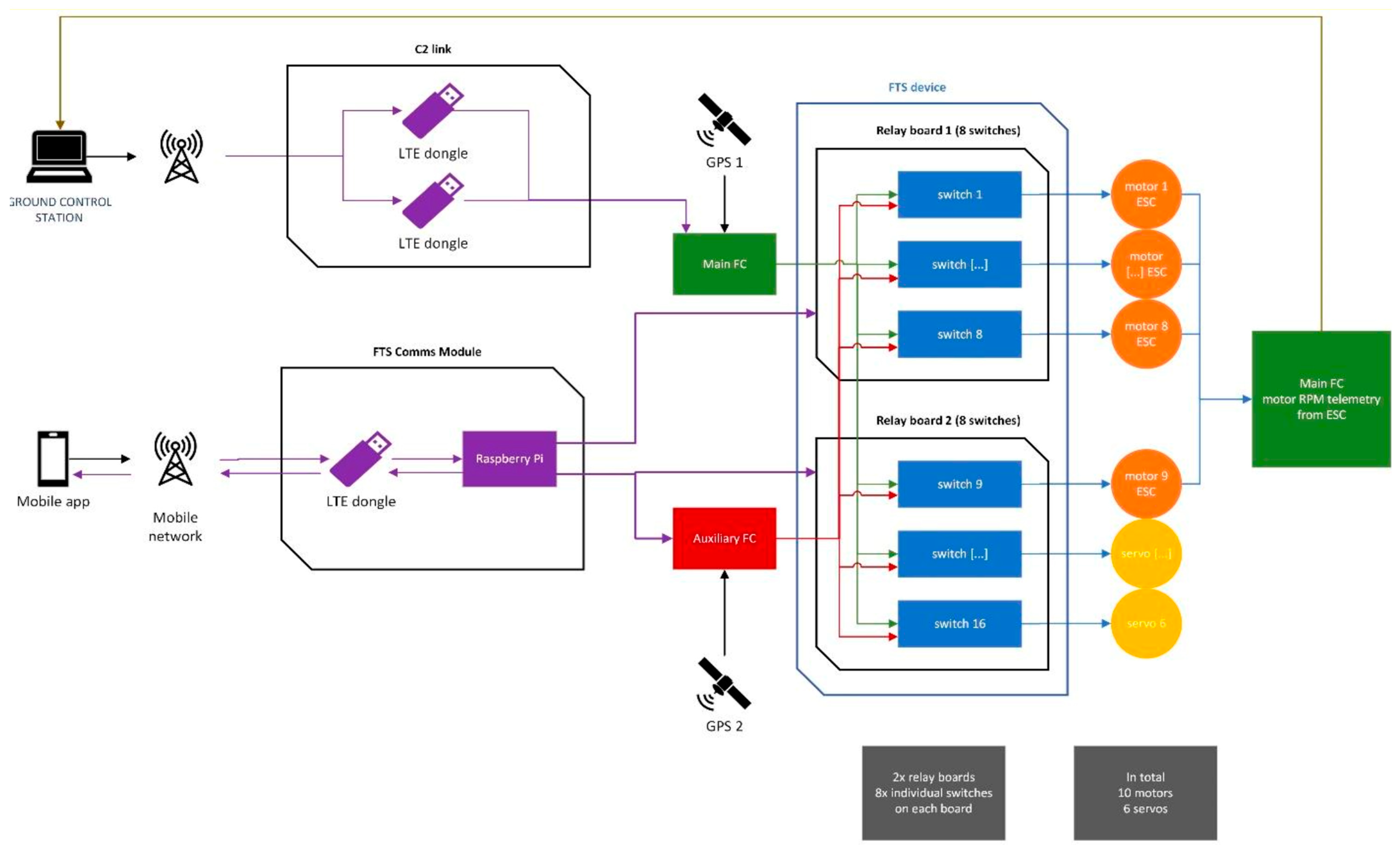
3.6. Functionality of the Flight Termination System (FTS)

The Flight Termination System (FTS) is a critical safety feature designed to ensure the controlled stabilization and landing of a drone in the event of an emergency. The following table outlines the step-by-step process involved in the activation and operation of the FTS, from the initial command by the Remote Pilot in Command (RPIC) to the safe landing of the aircraft. This system is activated through a mobile app separate from the Ground Control Station (GCS), ensuring that the FTS operates independently of the primary control link (Table 9).

3.7. Comparative Analysis of Drone and Automobile Transportation Environments

To evaluate the suitability of drones and automobiles for medical sample transportation, a comparative analysis of their respective transportation environments was conducted. This analysis focused on key factors, including temperature control, vibration exposure, and speed, which are critical for maintaining the integrity of medical cargo during transit.
Drones, while offering faster delivery speeds, face challenges such as limited temperature control and higher vibration levels due to aerial movement, particularly during takeoff and landing. These factors make drones more susceptible to environmental conditions, potentially impacting sensitive medical materials. In contrast, automobiles typically provide a more stable environment with better insulation and climate control, reducing the risk of temperature fluctuations and vibration exposure. However, the speed of automobiles is more variable, depending on traffic and road conditions, and generally lower than that of drones (Table 10).

3.8. Overview of Hardware Components for Flight Termination System (FTS)

To ensure the reliable operation of the Flight Termination System (FTS), a range of specialized hardware components were utilized. These components include relay modules, communication modules, an auxiliary flight controller, and a high-performance computing platform. The following table provides a detailed overview of each component, including specifications and key attributes, to offer a clear understanding of the hardware setup used to support the FTS functionality (Table 11).

3.9. Control Parameters and Experiment Reliability

To ensure the reliability and consistency of the results, several control parameters were established during the experiment. These controls were implemented across all transportation modalities (drones, electric vehicles, and combustion vehicles) to minimize variability and ensure that the outcomes were directly comparable (Table 12).
  • Consistent Payload Weight: Each transportation mode was tested with a standardized payload weight of two kilograms, representing a typical medical sample package. This consistency ensured that variations in energy consumption and travel performance were due to the transportation mode rather than differences in payload.
  • Route Selection: Identical routes were used for all transportation modes, with careful attention to distance, terrain, and traffic conditions. The routes were pre-selected to include both urban and rural segments, with variations in altitude to simulate real-world medical logistics scenarios. GPS tracking was employed to ensure precise adherence to these routes across all tests.
  • Timing and Environmental Conditions: All tests were conducted during similar environmental conditions, particularly regarding temperature, wind speed, and precipitation, to eliminate these variables as confounding factors. Tests were scheduled during periods with consistent weather forecasts, and real-time monitoring ensured that any deviations were noted.
  • Calibration of Equipment: Prior to each set of tests, all vehicles and drones were calibrated to ensure accurate measurement of energy consumption and travel time. Drones were calibrated using the Pixhawk 4 flight controller for stability, while electric and combustion vehicles had their onboard systems reset and checked for accuracy in fuel or energy consumption readings.
  • Redundancy Checks: To verify the reliability of the data, multiple runs were conducted for each transportation mode, with at least three repetitions per route. The average values from these repetitions were used in the analysis to account for any anomalies or outliers.
  • Energy Consumption Monitoring: The energy consumption of each transportation mode was carefully monitored using specific equipment. Drones utilized the Mauch Power Module for precise current and voltage measurement, while electric vehicles relied on their onboard systems, and combustion vehicles were monitored using the OBD-II diagnostic tool.

4. Presentation and Discussion of Results

4.1. CO2 Emissions Analysis

The analysis of CO2 emissions revealed significant differences among the transportation modalities, with combustion cars exhibiting the highest average emissions at 159.5 g per kilometer (g/km). In contrast, electric cars emitted significantly less CO2, averaging 3.43 g/km, which represents only 2.15% of the emissions of combustion cars. Drones emerged as the most environmentally friendly option, displaying the lowest CO2 emissions at an average of 0.09 g/km—just 0.07% of the emissions of combustion cars and 2.6% of those from electric cars (Figure 2).
These findings align with existing literature on the environmental impact of transportation technologies. Goodchild and Toy (2018) demonstrated that drones could substantially reduce CO2 emissions in urban logistics due to their ability to avoid traffic and optimize delivery routes [6]. Similarly, Rashidzadeh et al. (2021) found that drones are particularly effective in reducing greenhouse gas emissions in the last-mile delivery of medical supplies, especially in challenging terrains [8]. The dramatic reduction in CO2 emissions observed with drone usage in our study supports these findings and underscores the potential of drone technology to contribute to sustainable healthcare logistics.

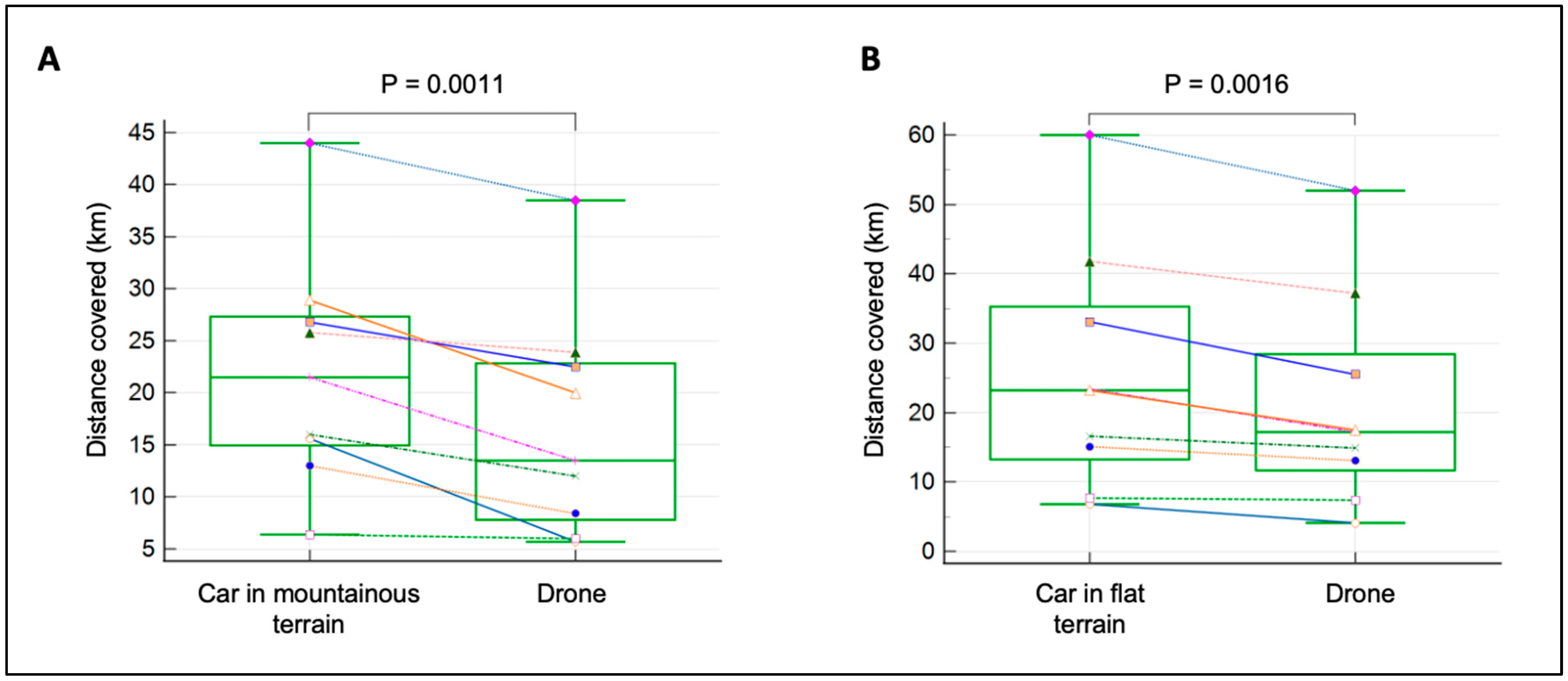
4.2. Transport Distance Efficiency

Drones also demonstrated notable efficiency advantages in terms of transport distances. On flat terrain, drones followed a path that was, on average, 17% shorter than that taken by cars (p = 0.0016). In mountainous terrain, drones showed an even greater reduction in transport distances, averaging 24% shorter routes compared to cars (p = 0.0011). These efficiencies are likely due to the ability of drones to navigate directly between points without the constraints of road networks (Figure 3).
This reduction in transport distances not only minimizes the environmental impact but also highlights the operational advantages of using drones for medical sample transportation. Previous studies, such as those by Park, Kim, and Suh (2018), have emphasized the importance of route optimization in reducing both emissions and delivery times in logistics operations [16]. Our findings further demonstrate that drones can achieve significant efficiencies in diverse geographical settings, making them a versatile solution for healthcare logistics.

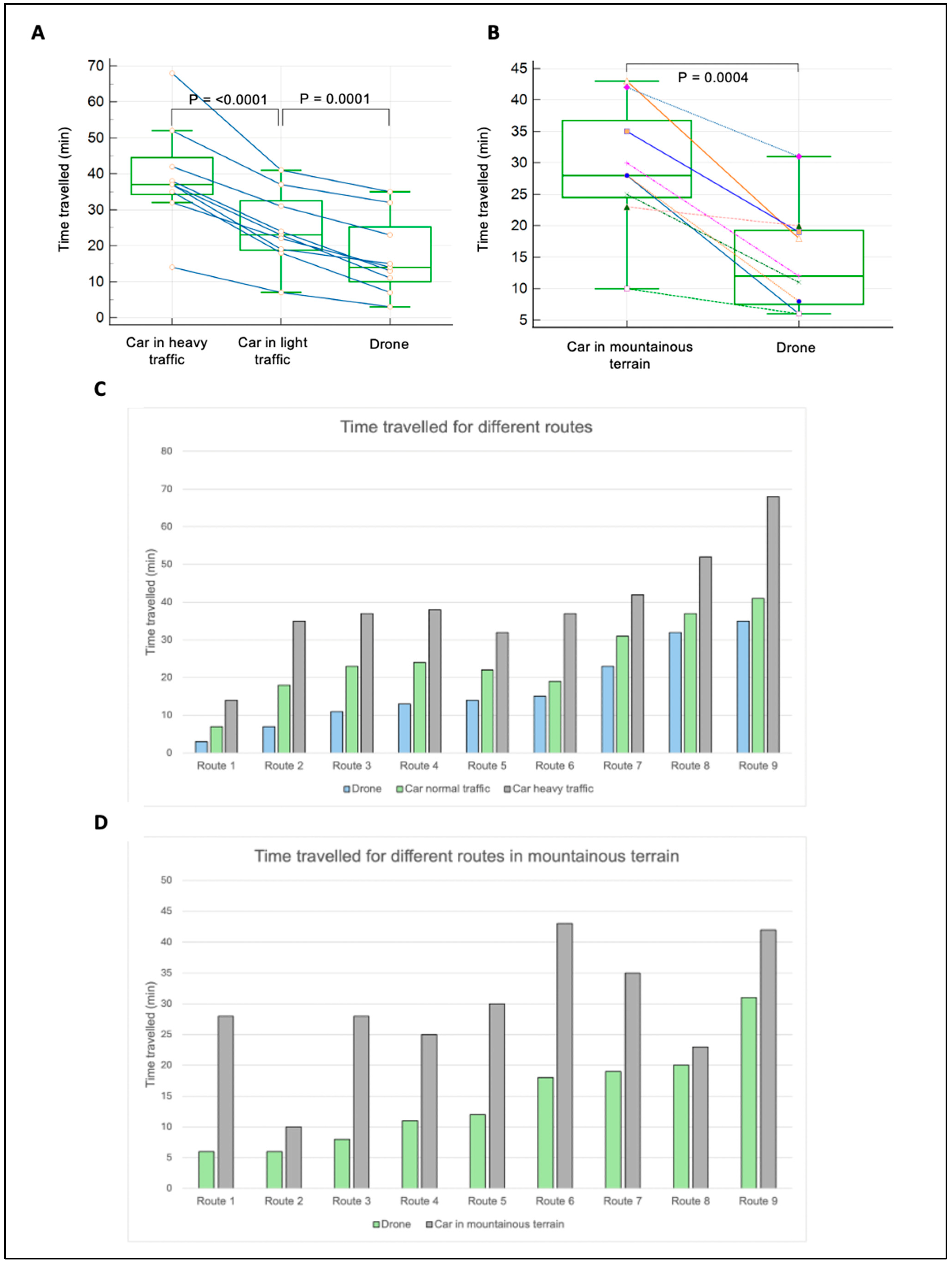
4.3. Delivery Time Efficiency

In addition to reducing CO2 emissions and transport distances, drones also provided substantial time savings. On flat terrain, drones were, on average, 31% faster than cars in light traffic (p = 0.0001) and 57% faster in heavy traffic (p = <0.0001). In mountainous terrain, drones delivered samples 50% faster than cars on average (p = 0.0004), with time savings ranging from 13% to 80% depending on the route (Figure 4).
Light traffic in this study refers to conditions with minimal delays and smooth vehicle flow, typically occurring during off-peak hours. Heavy traffic, by contrast, represents peak-hour congestion, characterized by slower speeds and frequent stops. However, it’s important to note that traffic classifications vary depending on the region, as conditions in one city or country may differ from those in another. These regional variations should be considered when interpreting the time savings achieved by the drones.
The significant time savings achieved by drones are crucial for healthcare logistics, where timely delivery of medical samples can directly impact patient outcomes. Previous research has shown that reducing transport times can minimize pre-analytical errors and improve the accuracy of diagnostic results (Peck Palmer et al., 2020) [17]. The ability of drones to bypass traffic and navigate challenging terrains quickly makes them an ideal solution for urgent medical deliveries.

4.4. Implications for Healthcare Logistics

The results of this study underscore the transformative potential of drone technology in reshaping healthcare logistics, particularly in terms of environmental sustainability and operational efficiency. The significant reductions in CO2 emissions, transport distances, and delivery times suggest that drones can effectively address some of the most pressing challenges in healthcare logistics, such as the need to minimize environmental impact while ensuring the timely delivery of medical samples.
One critical implication is the potential for drones to enhance healthcare accessibility, especially in remote or underserved regions. In areas with difficult terrain or inadequate road infrastructure, traditional vehicles often face significant delays, leading to compromised sample integrity and delayed diagnostics. Drones, however, can bypass these challenges by providing direct, fast routes between healthcare facilities and laboratories, ensuring that medical samples are delivered swiftly and in optimal condition. This capability is particularly crucial in emergency situations, where the timely arrival of diagnostic samples can directly influence patient outcomes. For example, in remote parts of Rwanda and Ghana, drones have already proven effective in delivering essential medical supplies, significantly improving healthcare access in these regions [6,11].
Moreover, the significant reduction in CO2 emissions achieved through drone use aligns with global initiatives aimed at combating climate change. The healthcare sector, traditionally a significant contributor to carbon emissions due to its reliance on energy-intensive processes and transportation, can play a pivotal role in sustainability efforts by adopting drone technology. The alignment of drone usage with the objectives of international agreements such as the Paris Agreement demonstrates the sector’s ability to contribute meaningfully to global carbon reduction targets [18]. By reducing reliance on combustion vehicles, healthcare systems can lower their overall carbon footprint, thus contributing to a more sustainable and environmentally responsible healthcare system.
Additionally, drones offer operational advantages beyond environmental benefits. The efficiency gains from reduced transport distances and faster delivery times translate into cost savings, improved resource allocation, and enhanced service quality. For healthcare providers, this means better utilization of human resources and more efficient use of laboratory and diagnostic facilities, which can ultimately lead to improved patient care. The operational flexibility of drones, capable of navigating complex terrains and urban environments alike, makes them a versatile tool in the logistics arsenal of modern healthcare systems.
Furthermore, the broader implications of adopting drone technology in healthcare logistics extend to addressing challenges in last-mile delivery, particularly in rural and difficult-to-access areas. Studies have shown that drones can effectively overcome geographical barriers, providing critical services where traditional transportation methods may be impractical or too costly [6,8,19]. The ability to reach remote locations swiftly also supports initiatives aimed at improving healthcare delivery in regions with limited access to medical facilities, contributing to overall health equity [11,20,21,22,23].

4.5. Comparative Analysis with Existing Studies

Our findings are consistent with and expand upon existing studies that have examined the environmental and operational benefits of drone and electric vehicle technologies in logistics. For instance, Goodchild and Toy (2018) highlighted that drones can substantially reduce CO2 emissions in urban delivery contexts by avoiding traffic and optimizing delivery routes, which resonates with the significant emission reductions observed in our study [6]. Similarly, Rashidzadeh et al. (2021) explored the sustainability of drones in last-mile delivery, particularly in the healthcare sector, where they found that drones significantly reduce greenhouse gas emissions and enhance delivery efficiency, especially in challenging terrains [8].
Rodrigues et al. (2022) further support our findings by showing that drones can achieve notable energy and emissions savings in the delivery of small packages, particularly in rural areas where traditional delivery methods are less efficient [14]. The efficiency gains we observed, particularly in mountainous regions, align with these findings and underscore the potential for drones to serve as a reliable and sustainable alternative in healthcare logistics.
Moreover, our study contributes to the growing body of literature by providing empirical evidence specific to the healthcare sector in central Europe, where geographical diversity and varying climate conditions present unique challenges. The significant time savings observed in our study also echo the conclusions of Garg et al. (2023), who found that drones could revolutionize last-mile delivery services by offering faster and more sustainable transportation options in both urban and rural settings [19]. This efficiency is particularly critical in healthcare, where delays can have direct consequences on patient outcomes.
Furthermore, the integration of drone technology in healthcare logistics also aligns with efforts to address broader environmental and public health concerns. For instance, Kuczewska, Bartoszewski, and Ekiert-Radecka (2022) emphasized the dual benefits of reducing air pollution and ensuring the effective delivery of medical products through autonomous drone delivery [13]. These efforts are further supported by studies like those of Koshta et al. (2022), which highlighted the potential of drones to overcome logistical barriers in rural healthcare supply chains, thus preparing healthcare systems for future challenges [24].
In addition, studies focusing on the economic and operational aspects, such as those by Sudbury and Hutchinson (2016), have indicated that the cost-effectiveness of drone delivery systems, particularly in Amazon’s Prime Air program, could be adapted to healthcare logistics to optimize costs while enhancing service quality [25]. This is complemented by research from Shen et al. (2021), which explored the optimization of multi-warehouse drone delivery systems, suggesting that similar frameworks could be applied to healthcare logistics to manage complex supply chains effectively [26].
In summary, the integration of drone technology into healthcare logistics offers a promising pathway toward achieving a more sustainable, efficient, and resilient healthcare system. By reducing CO2 emissions, optimizing transport routes, and minimizing delivery times, drones not only contribute to environmental sustainability but also enhance the operational effectiveness of healthcare services. These findings suggest that drones, alongside electric vehicles, could play a central role in the future of healthcare logistics, addressing both environmental and logistical challenges in this critical sector [27].

4.6. Efficiency and Benefits of Electric Vehicles and Drones

In our study, drones demonstrated an average reduction in CO2 emissions of 57% compared to combustion cars under heavy traffic conditions, which is consistent with the findings of Hur and Won (2024), who reported a 35–45% reduction in urban settings [9]. The reduction in CO2 emissions in our study was more pronounced in mountainous terrains, where drones reduced emissions by up to 80%, outperforming both electric vehicles and combustion cars. In comparison, the study by Pani et al. (2020) showed drones achieving similar reductions, particularly when avoiding congested roads in urban environments [28]. Furthermore, our results align with the findings of Rodrigues et al. (2022), where electric vehicles reduced emissions by approximately 60% compared to combustion cars, while our study showed a 50–65% reduction, depending on the terrain [14].

4.7. Logistical and Legal Challenges of Drone Use

Integrating drone technology into healthcare logistics presents several logistical and legal challenges that must be addressed. Regulatory restrictions, such as those in the United States, where drones must remain within the operator’s visual line of sight, limit the range of drone operations, particularly in urban settings. This limitation can restrict the effectiveness of drones unless paired with ground vehicles for extended coverage [11,24].
Safety is another concern, especially when operating in populated areas or near critical infrastructure. Drones must be equipped with fail-safes and redundancy systems to ensure the secure transport of medical samples, which is vital for time-sensitive deliveries [20,21].
Accurate delivery is essential in medical logistics, requiring precise location identification to avoid delays or errors. This challenge is more pronounced in diverse environments, where reliable GPS signals are crucial for successful operations [22]. Additionally, certain medical supplies need strict temperature controls during transport, necessitating drones equipped with specialized storage to maintain the integrity of these items [23].
While these challenges are significant, advancements in drone technology, such as beyond-visual-line-of-sight (BVLOS) operations and improved navigation systems, are expected to overcome many of these barriers, making drones increasingly viable for healthcare logistics.

4.8. Value and Significance of the Comparative Analysis

While it may be expected that combustion vehicles emit the most CO2, this study provides essential empirical data that quantify these differences in the specific context of healthcare logistics. This information is crucial for making informed decisions that balance environmental impact with operational needs.
Comparing drones with traditional vehicles is particularly valuable as it demonstrates the potential of drones to not only reduce emissions but also improve logistical efficiency, such as through shorter routes and faster delivery times. These insights are directly applicable to optimizing healthcare logistics and reducing the sector’s carbon footprint. While future research could explore other modes like rail or water transport, our focus on drones and road vehicles addresses the immediate and practical needs of healthcare logistics.

4.9. Cost Considerations in Healthcare Logistics

Cost is a critical factor in the adoption of transportation modes for healthcare logistics. Drones may have higher initial costs due to specialized equipment and regulatory compliance. For instance, the purchase of a high-efficiency hybrid drone like those studied could range from USD 10,000 to USD 50,000, depending on capabilities and storage systems [8]. However, these costs can be offset by savings in fuel, reduced delivery times, and lower emissions, which can lead to long-term savings, particularly in regions where fuel costs are high and delivery speed is critical [6,16].
Electric vehicles, while more expensive upfront than combustion vehicles—with prices for models like the Tesla Model 3 starting around USD 40,000—benefit from lower operational costs. For example, electricity prices are generally lower than fuel, and electric vehicles typically require less maintenance due to fewer moving parts [14]. Additionally, the increasing availability of incentives and subsidies for electric vehicles could further reduce the total cost of ownership, making them an attractive option for healthcare providers [19,25].
In contrast, combustion vehicles, while generally cheaper to purchase (with models like the Renault Kangoo starting around USD 25,000), incur higher fuel costs—averaging USD 0.12 to USD 0.15 per kilometer in fuel consumption—and contribute significantly to greenhouse gas emissions [29,30]. These factors make combustion vehicles less attractive in the long term, especially as environmental regulations tighten and carbon pricing becomes more prevalent [13,18].
Healthcare providers must weigh both short-term and long-term costs when choosing between drones, electric vehicles, and combustion vehicles, balancing financial implications with sustainability goals.

4.10. Limitations and Generalizability

One limitation of this study is its spatial scope, which focused on specific routes in Liechtenstein and Switzerland. While these regions provided a diverse range of terrains and weather conditions that are relevant to healthcare logistics, the findings may not be fully generalizable to other regions with different geographic or infrastructural characteristics. For example, areas with less developed road networks or different regulatory environments might experience different outcomes when integrating drones into their logistics operations.
However, the methods and insights gained from this study can still serve as a valuable framework for other regions. Future research could extend this analysis to other areas or include comparisons with additional transportation modes, such as rail or water transport, to provide a broader understanding of sustainable logistics options. Additionally, further studies could explore the scalability of drone operations in more complex urban environments or over longer distances, which would help in understanding the full potential and limitations of drones in diverse healthcare settings.

4.11. Operational Constraints of Drones

While drones have great potential in healthcare logistics, they face several operational challenges. Legal restrictions, such as the need for drones to stay within the operator’s visual line of sight, limit their range, especially in urban or complex environments. This often requires combining drones with ground vehicles for effective delivery [11,24].
Transporting certain medical supplies also poses challenges, particularly for temperature-sensitive items that need controlled environments during transit. Drones must be equipped with specialized storage systems to maintain these conditions [22,23].
Moreover, precise delivery is critical in medical logistics. Drones must accurately locate and reach the correct destination, as any errors could cause delays or failures in delivering essential supplies. Advances in GPS and autonomous navigation systems will be key to overcoming these constraints and ensuring the reliability of drone deliveries in healthcare.

5. Conclusions

This study provides compelling evidence that integrating drone technology into healthcare logistics can lead to substantial improvements in both environmental sustainability and operational efficiency. Our findings demonstrate that drones offer significant reductions in CO2 emissions, transport distances, and delivery times compared to traditional combustion vehicles and even electric cars. These advantages are particularly pronounced in challenging terrains, such as mountainous regions, where drones can navigate more efficiently and avoid the limitations imposed by road infrastructure.
The potential for drones to enhance healthcare accessibility, particularly in remote or underserved areas, underscores their value as a transformative tool in healthcare logistics. By ensuring faster, more reliable delivery of medical samples, drones can help to improve patient outcomes and contribute to the overall resilience of healthcare systems. Furthermore, the alignment of drone technology with global sustainability goals, such as those outlined in the Paris Agreement, positions the healthcare sector as a leader in the fight against climate change.
The integration of drones into healthcare logistics also presents opportunities for cost savings, better resource utilization, and enhanced service quality. These operational benefits, combined with the environmental advantages, suggest that drones are not just a viable alternative but a superior solution for certain logistics challenges within the healthcare sector.
However, the practical implementation of drones at scale will require addressing regulatory, logistical, and technological challenges. Future research should focus on developing strategies for integrating drones with existing transportation networks, ensuring compliance with airspace regulations, and optimizing drone operations for various healthcare contexts.
In conclusion, this study highlights the potential of drones to revolutionize healthcare logistics, offering a sustainable, efficient, and resilient alternative to traditional transportation methods. As healthcare systems worldwide strive to reduce their environmental impact while improving service delivery, the adoption of drone technology represents a significant step forward in achieving these objectives.

Author Contributions

Conceptualization, N.S., H.R., L.R. and M.R.; methodology, N.S. and L.R.; formal analysis, N.S.; resources, L.R. and M.R.; data curation, N.S. and F.L.; writing—original draft preparation, N.S.; writing—review and editing, N.S., L.R., F.L. and M.R.; visualization, N.S.; supervision, L.R. All authors have read and agreed to the published version of the manuscript.

Funding

This research received no external funding.

Data Availability Statement

The original contributions presented in the study are included in the article, further inquiries can be directed to the corresponding author.

Acknowledgments

We would like to extend our deepest gratitude to all those who contributed to this research. Our heartfelt thanks to the laboratory personnel and transportation service providers in the Principality of Liechtenstein and Switzerland for their invaluable support and cooperation during the data collection phase. Special thanks to Lorenz Risch, and Martin Risch for their unwavering guidance and expertise. We are also grateful to the environmental experts and stakeholders who participated in our workshops, offering their insights and helping us prioritize the criteria for evaluating transportation modalities. Their contributions were crucial in shaping the direction and scope of this study. Our appreciation goes to the Swiss Federal Office for the Environment (FOEN) for providing the established methodologies and tools necessary for the accurate calculation of CO2 footprints. The technical and logistical support received from various institutions and organizations has been instrumental in the successful completion of this research. Lastly, we thank our families and friends for their constant encouragement and understanding throughout this journey. Without their support, this work would not have been possible.

Conflicts of Interest

The authors declare no conflicts of interest.

References

  1. Angelov, S.; Jimenez, C.K.; Wall, V.; O’Croínin, D. An assessment of sustainable transport infrastructure in a national healthcare system. Surgeon 2023, 22, 203–208. [Google Scholar] [CrossRef] [PubMed]
  2. Berniak-Woźny, J.; Rataj, M. Towards green and sustainable healthcare: A literature review and research agenda for green leadership in the healthcare sector. Int. J. Environ. Res. Public Health 2023, 20, 908. [Google Scholar] [CrossRef] [PubMed]
  3. Cawthorne, D.; Robbins-Van Wynsberghe, A. From HealthDrone to FrugalDrone: Value-sensitive design of a blood sample transportation drone. In Proceedings of the 2019 IEEE International Symposium on Technology and Society (ISTAS), Boston, MA, USA, 15–16 November 2019; IEEE: Piscataway, NJ, USA, 2019. [Google Scholar]
  4. Lenzen, M.; Malik, A.; Li, M.; Fry, J.; Weisz, H.; Pichler, P.P.; Chaves, L.S.M.; Capon, A.; Pencheon, D. The environmental footprint of health care: A global assessment. Lancet Planet. Health 2020, 4, e271–e279. [Google Scholar] [CrossRef] [PubMed]
  5. Eckelman, M.J.; Sherman, J. Environmental impacts of the US health care system and effects on public health. PLoS ONE 2016, 11, e0157014. [Google Scholar] [CrossRef] [PubMed]
  6. Goodchild, A.; Toy, J. Delivery by drone: An evaluation of unmanned aerial vehicle technology in reducing CO2 emissions in the delivery service industry. Transp. Res. Part D Transp. Environ. 2018, 61, 58–67. [Google Scholar] [CrossRef]
  7. Magnusson, S.; Hagerfors, P.P. Drone Deliveries of Medical Goods in Urban Healthcare. Master’s Thesis, Chalmers University of Technology, Gothenburg, Sweden, 2019. [Google Scholar]
  8. Rashidzadeh, E.; Molana, S.M.H.; Soltani, R.; Hafezalkotob, A. Assessing the sustainability of using drone technology for last-mile delivery in a blood supply chain. J. Model. Manag. 2021, 16, 1376–1402. [Google Scholar] [CrossRef]
  9. Hur, S.H.; Won, M. CO2 emissions and delivery time of last-mile drone delivery using trucks. IET Intell. Transp. Syst. 2024, 18, 101–113. [Google Scholar] [CrossRef]
  10. Li, X.; Tupayachi, J.; Sharmin, A.; Ferguson, M.M. Drone-Aided Delivery Methods, Challenge, and the Future: A Methodological Review. Drones 2023, 7, 191. [Google Scholar] [CrossRef]
  11. Olatunji, G.M.; Isarinade, T.D.M.; Emmanuel, K.M.; Olatunji, D.M.; Aderinto, N.M. Exploring the transformative role of drone technology in advancing healthcare delivery in Africa; A perspective. Ann. Med. Surg. 2023, 85, 5279–5284. [Google Scholar] [CrossRef]
  12. Nybo, M.; Cadamuro, J.; Cornes, M.P.; Gómez Rioja, R.; Grankvist, K. Sample transportation—An overview. Diagnosis 2019, 6, 39–43. [Google Scholar] [CrossRef]
  13. Kuczewska, H.; Bartoszewski, B.; Ekiert-Radecka, M. Reduction of air pollution and solving the problem of effective delivery of medical products with autonomous drone delivery. In Proceedings of the 22nd SGEM International Multidisciplinary Scientific GeoConference, Albena, Bulgaria, 4–10 July 2022; pp. 391–398. [Google Scholar]
  14. Rodrigues, T.A.; Patrikar, J.; Oliveira, N.L.; Matthews, H.S.; Scherer, S.; Samaras, C. Drone flight data reveal energy and greenhouse gas emissions savings for very small package delivery. Patterns 2022, 3, 100569. [Google Scholar] [CrossRef] [PubMed]
  15. Lee, J. Optimization of a modular drone delivery system. In Proceedings of the 11th Annual IEEE International Systems Conference (SysCon), Montreal, QC, Canada, 24–27 April 2017; IEEE: Piscataway, NJ, USA, 2017. [Google Scholar]
  16. Park, J.; Kim, S.; Suh, K. A Comparative Analysis of the Environmental Benefits of Drone-Based Delivery Services in Urban and Rural Areas. Sustainability 2018, 10, 888. [Google Scholar] [CrossRef]
  17. Peck Palmer, O.M.; Wheeler, S.E.; Plebani, M.; Patterson, P.D.; Korpi-Steiner, N.L.; Martin, C. Recognition of the prehospital preanalytical phase: Collaborative efforts between laboratory medicine and emergency medicine to ensure quality testing. Clin. Chem. 2020, 66, 998–1005. [Google Scholar] [CrossRef] [PubMed]
  18. Paris Agreement. “Paris Agreement” Report of the Conference of the Parties to the United Nations Framework Convention on Climate Change (21st Session, 2015: Paris); HeinOnline: Getzville, NY, USA, 2015; Volume 4, No. 2017. [Google Scholar]
  19. Garg, V.; Niranjan, S.; Prybutok, V.; Pohlen, T.; Gligor, D. Drones in last-mile delivery: A systematic review on Efficiency, Accessibility, and Sustainability. Transp. Res. Part D Transp. Environ. 2023, 123, 103831. [Google Scholar] [CrossRef]
  20. Kim, S.J.; Lim, G.J.; Cho, J.; Côté, M.J. Drone-Aided Healthcare Services for Patients with Chronic Diseases in Rural Areas. J. Intell. Robot. Syst. 2017, 88, 163–180. [Google Scholar] [CrossRef]
  21. Nyaaba, A.A.; Ayamga, M. Intricacies of medical drones in healthcare delivery: Implications for Africa. Technol. Soc. 2021, 66, 101624. [Google Scholar] [CrossRef]
  22. Haula, K.; Agbozo, E. A systematic review on unmanned aerial vehicles in Sub-Saharan Africa: A socio-technical perspective. Technol. Soc. 2020, 63, 101357. [Google Scholar] [CrossRef]
  23. Jain, V.; Luthra, N. Medical assistance using drones for remote areas. In Proceedings of the International Conference on Artificial Intelligence and Applications: ICAIA, New Delhi, India, 6–7 February 2020; Springer: Singapore, 2021. [Google Scholar]
  24. Koshta, N.; Devi, Y.; Chauhan, C. Evaluating Barriers to the Adoption of Delivery Drones in Rural Healthcare Supply Chains: Preparing the Healthcare System for the Future. IEEE Trans. Eng. Manag. 2022, 71, 13096–13108. [Google Scholar] [CrossRef]
  25. Sudbury, A.W.; Hutchinson, E.B. A cost analysis of amazon prime air (drone delivery). J. Econ. Educ. 2016, 16, 1–12. [Google Scholar]
  26. Shen, Y.; Xu, X.; Zou, B.; Wang, H. Operating policies in multi-warehouse drone delivery systems. Int. J. Prod. Res. 2020, 59, 2140–2156. [Google Scholar] [CrossRef]
  27. Kreier, F. Drones bearing parcels deliver big carbon savings. Nature 2022. [Google Scholar] [CrossRef] [PubMed]
  28. Pani, A.; Mishra, S.; Golias, M.; Figliozzi, M. Evaluating public acceptance of autonomous delivery robots during COVID-19 pandemic. Transp. Res. Part D Transp. Environ. 2020, 89, 102600. [Google Scholar] [CrossRef]
  29. Šimenc, M. Overview and comparative analysis of emission calculators for inland shipping. Int. J. Sustain. Transp. 2015, 10, 627–637. [Google Scholar] [CrossRef]
  30. Shadimetov, Y.; Ayrapetov, D.; Ergashev, В. Transport, ecology and health. Transport 2021, 4, 17226–17230. [Google Scholar]
Figure 1. Functional diagram of the drone transportation system: Illustrates the operational workflow of the drone system, detailing its components, including the flight planning system, navigation, and contingency features, as well as its integration into the healthcare logistics process.
Drones 08 00489 g001
Figure 2. (A) CO2 emission of combustion cars, electric cars and drones per km traveled on logarithmic scaling. (B) Displays the differences in CO2 emissions produced by drones, electric vehicles, and combustion cars during medical sample transportation, highlighting the environmental benefits of each method. Ratio of CO2 emission from the different transportation vehicles.
Drones 08 00489 g002
Figure 3. Distance of transport method covered for the same route compared on nine different routes each on flat terrain (B) and on mountainous (A) terrain. Dots connected by lines represent the same route traveled.
Drones 08 00489 g003
Figure 4. Time of transport method compared over different routes. (A) Minutes traveled by a car in heavy traffic, light traffic and by the drone on flat terrain and nine different routes (B) Minutes traveled by a car and the drone compared on nine mountainous routes. Lines connected represent the same route traveled by the different transport methods. (C) Time traveled in comparison for each route separately for flat terrain with heavy or light traffic respectively. (D) Time traveled for reach route on mountainous terrain.
Drones 08 00489 g004
Table 1. Detailed specifications of transportation modalities used for medical sample transportation.
Transportation ModalityModels/Technology
Combustion CarsMercedes Vito (2020),
Renault Kangoo (2022),
Peugeot 2008 (2021), 208 (2020), 308 (2023),
VW Polo (2019),
Citroen C3 (2022),
Skoda Fabia (2019)
Electric CarsTesla Model 3 (2023), Tesla Model X (2021),
DroneHybrid drone from Jedsy.ch with glider technology, transitions to hover mode while landing
Table 2. Lists the specifications of the hybrid drone, including its flight duration, average altitude, and weather conditions under which it was tested.
Aircraft TypeUnmanned Electric Aircraft, Capable of Vertical Takeoff and Landing (eVTOL) and Fixed-Wing Flight. x
Dimensions35 × 290 × 240 cm [H × W × L]
Weight18 kg empty incl. batteries
21 kg max. gross takeoff weight (MGTOW)
PropulsionHovering motors: 8 × 150 Kv motors with 22-inch propellers (IP 45 rating)
Cruising motors: 2 × 360 Kv motors with 12-inch propellers
Avionics1 × 64 Bit ARM 6 Cores, 6 MB L2 + 4 MB L3, 8 GB RAM, 128-Bit-LPDDR4x 59.7 GB/s
1 × 32 Bit ARM, 480 MHz, 2 MB memory, 512 KB RAM
1 × 32 Bit ARM, 24 MHz, 8 KB SRAM (3× Accelerometers/Gyros, 2× Barometers, 2× airspeed sensors, 1× GPS Module)
1 × 32 Bit ARM, 480 MHz, 2 MB memory, 512 KB RAM
1 × 32 Bit ARM, 72 MHz, 64 KB SRAM (2× Accelerometers/Gyros, 2× Barometers, 1× GPS Module)
Awareness systems1× downward-facing awareness systems
2× forward-facing awareness systems
1× LiDAR ground altimeter: downward facing for long-range
Awareness radios1× ADS-B In
1× FLARM in and out
1× remote ID, compliant with FAR Part 89
Connectivity (CON2)3× LTE SIM cards slots for three different providers
Flight modesMulticopter mode and Fixed-wing mode
Cruise Speed59 KIAS (30 m/s)
Stall Speed (MGTOW) in Fixed-wing mode33 KIAS (17 m/s)
Max Density Altitude2438 m
Max Endurance 118 min
Max Wind29 KTS (15 m/s)
Max Precipitation Light to moderate
Operating timeDay
Night (under dev)
Operating temperature−20 °C to 50 °C
Rangemax 120 km, 2 min hovering, 3 kg payload, 5 m/s of headwind, ideal cruising speed, 200 m AMSL, no altitude changes or curves, 10% reserve
Weather limitationssuitable for operation in coastal and offshore climate
no operation during heavy rain, icing conditions, hail, and thunderstorms
Noise EmissionsWhile cruising at 60 m above ground level: 58 dB
Delivery methodsMailbox docking on balcony or window (under development)
Ground landing
Customer Privacy The video transmitted to the pilot for landing is blurred at the source
Table 3. Summary of flight planning and execution details. The table summarizes the flight planning and execution details, including the software used, flight paths, average altitude (100 m), number of flights (12), flight duration (30 min each), and weather conditions like light rain, winds up to 40 km/h, and sunshine.
Flight PlanningDetails
Software UsedPix4D and PX4 Autopilot
Flight PathsDetailed paths planned to cover the entire study area, ensuring comprehensive coverage and data overlap
AltitudeAverage altitude of 100 m (see Table 1 and Table 2 for specifics)
Flight ExecutionDetails
Number of Flights12 flights conducted over the study period
DurationEach flight lasted approximately 30 min
Weather ConditionsVarious conditions including light rain, winds (up to 40 km/h), and sunshine
Table 4. Flight geography: Summarizes the flight geography used for drone operations in the study. It details the coordinates, terrain types, and distances involved in each flight route, which were carefully selected to reflect real-world conditions. This table plays a critical role in illustrating the diverse environments in which the drone was tested, helping to evaluate its adaptability across different terrains.
Cruising TypeHorizontal RangeVertical Range
Horizontally35 m on each side of the Flight Path.
Vertically 20 m above the Flight Path -> 120 m AGL
Hovering
Horizontally
10 m on each side of the flight path.
This accounts for the low speed of the aircraft.
Hovering
Vertically
10 m above the Flight Path -> 40 m AGL
This accounts for the low speed of the aircraft.
Table 5. Contingency Volume: Describes the contingency volume established for drone flights in the event of emergency situations. This table highlights the safety protocols and operational steps designed to ensure the safe stabilization and landing of the drone. It provides a detailed overview of the conditions that could trigger the use of the contingency system, ensuring that operational risks are minimized.
Cruising TypeHorizontal RangeVertical Range
Horizontally35 m on each side of the Flight Path.
Vertically 20 m above the Flight Path -> 150 m AGL
Hovering
Horizontally
10 m on each side of the flight geography
Hovering
Vertically
10 m above the Flight Geography -> 50 m AGL
Table 6. Environmental conditions for drone testing: Highlights the environmental factors such as wind speed, temperature, and other weather variables encountered during drone testing.
ConditionRange TestedPerformance MetricsEquipment Used
Wind SpeedUp to 30 km/h (moderate wind)Stable flight, minor adjustments requiredPixhawk 4 flight controller, Anemometer (Vortex)
Temperature−5 °C to 35 °CMaintained operational integrity, no temperature-related failuresBosch BME280 sensor, Peltier coolers
PrecipitationLight rain (up to 2.5 mm/h)No impact on flight; sealed components functioned as expectedIP67-rated sealed electronics, Hydrophobic coating
Humidity20% to 90%No significant impact on drone electronics or flightBosch BME280 sensor
Altitude Changes0 to 500 m above sea levelMaintained consistent altitude controlLIDAR-Lite v3 sensor, Pixhawk 4 flight controller
Table 7. Routes traveled in flat terrain: Details the specific routes selected for testing on flat terrain, highlighting distance and terrain characteristics for each transportation modality.
Name of Route Start and DestinationStart and Destination (GPS)
Route 1Buchs SG–Vaduz 47.166668, 9.466664–47.134787, 9.513150
Route 2Zürich Tiefenbrunnen–Zürich Oerlikon47.351448, 8.559639–47.406385, 8.542571
Route 3Meilen–Zürich47.272483, 8.652122–47.351448, 8.559639
Route 4Meilen–Rapperswil47.272483, 8.652122–47.220530, 8.843807
Route 5Chur–Grüsch46.856858, 9.517722–46.977926, 9.644353
Route 6Buchs SG–Mels47.166668, 9.466664–47.036573, 9.436659
Route 7Glarus–Walenstadt47.036125, 9.065019–47.118043, 9.310155
Route 8Buchs SG–Chur47.166668, 9.466664–46.856858, 9.517722
Route 9Buchs SG–Stephanshorn SG47.166668, 9.466664–47.446111, 9.410633
Table 8. Routes traveled in mountainous terrain: Describes the routes used in mountainous regions, with information on distances and elevation changes that influenced the transportation tests.
Name of Route Start and DestinationStart and Destination (GPS)
Route 1Buchs SG–Gaflei47.166668, 9.466664–47.142344, 9.544172
Route 2Meilen–Oetwil am See47.272483, 8.652122–47.267415, 8.728000
Route 3Lugano–Bidogno46.023625, 8.961412–46.081164, 8.999985
Route 4Buchs SG–Wildhaus47.166668, 9.466664–47.202323, 9.349811
Route 5Buchs SG–Malbun47.166668, 9.466664–47.103642, 9.607433
Route 6Chur–Arosa46.856858, 9.517722–46.784364, 9.683340
Route 7Saas-Fee–Visp46.110250, 7.931477–46.297230, 7.874027
Route 8Albula–Bonaduz46.663515, 9.575630–46.808014, 9.403732
Route 9Davos–Landquart46.797116, 9.825824–46.961172, 9.566139
Table 9. Functionality of the Flight Termination System (FTS): Summarizes the specialized hardware components that support the FTS, including their specifications and key functionalities.
StepAction
1The RPIC activates the FTS using a mobile phone app, which is segregated from the Ground Control Station (GCS).
2The app sends the activation command through the mobile network to the FTS comms module installed on the aircraft, using a different network provider from the C2 link.
3The FTS comms module activates the FTS device.
4The FTS reroutes the motor and servo inputs to be controlled by the auxiliary Flight Controller, which is pre-programmed to stabilize and stop the aircraft in Hovering mode as quickly as possible (approx. 4G deceleration).
5The aircraft navigates to the horizontal GPS location where the FTS was triggered, remaining in Hovering mode at a slow speed of 5 m/s.
6The aircraft turns into the wind using the weathervane function to allow the Cruising motor to counter the wind more efficiently.
7The aircraft slowly descends at 3 m/s or less until touchdown.
8The aircraft is disarmed upon touchdown.
9The RPIC can disable the FTS at any time using the same segregated trigger, regaining full control of the aircraft (only in the case of inadvertent activation).
Table 10. Comparative Analysis of Drone and Automobile Transportation Environments.
FactorDrone Transportation EnvironmentAutomobile Transportation Environment
Temperature ControlLimited control; highly dependent on external weather conditions.Typically more stable with better insulation and climate control.
Vibration ExposureHigh due to aerial movement, especially during takeoff, landing, and flight.Moderate to low; roads provide a relatively stable platform, though road quality can cause variations.
SpeedVariable; average cruising speed around 30 m/s (59 KIAS).Variable; average speed ranges from 13 m/s (47 km/h) to urban areas to 27 m/s (100 km/h) on highways.
AltitudeOperates at varying altitudes (e.g., 100 m above ground).Operates at ground level; altitude variation is negligible.
Environmental ExposureDirect exposure to weather conditions (wind, rain, temperature).Typically shielded from direct weather impacts due to the vehicle’s structure.
Impact of WeatherSignificant; wind, rain, and temperature directly affect flight stability.Minimal; vehicles are designed to operate in various weather conditions, though extreme conditions may affect safety.
Reliability of TransportationPotentially affected by weather, requiring contingency planning.Generally more reliable, with less susceptibility to environmental conditions.
Energy EfficiencyDependent on altitude, payload, and wind conditions; can vary significantly.Generally more consistent; efficiency depends on driving conditions and vehicle type.
Infrastructure DependencyRequires minimal infrastructure (e.g., clear airspace, GPS).Requires extensive road infrastructure and is subject to traffic conditions.
Table 11. Overview of hardware components for Flight Termination System (FTS): Summarizes the specialized hardware components that support the FTS, including their specifications and key functionalities.
Component.Details
FTS DeviceRelay Modules (2×)
Specifications- Relay switching current: approx. 8 × 60 mA
- Operating voltage: 3.3 V to 5 V
- 8x relay (DC: max. 30 V/10 A, AC: max. 250 V/10 A)
- Relay with 3 contacts (change switch)
- Direct control via microcontroller digital output
- Header pin for control RM 2.54 mm
- 8 × 3 screw terminals each for load connection
- 8× status LED for relay status
- 4× mounting holes 3 mm
- Size: 138 × 50 × 19 mm
- Weight: 105 g
FTS Comms ModuleLTE Dongle
Features- Provides LTE connectivity for communication
- Compact and easy to integrate with the FTS system
Key Attributes- BCM 2835 SOC @ 1 GHz
- 512 MB RAM
- Onboard wireless LAN (2.4 GHz 802.11 b/g/n)
- Onboard Bluetooth 4.1 + HS Low-energy (BLE)
- micro-SD slot
- mini HDMI type C connection
- 1x micro-B USB for data
- 1x micro-B USB for power supply
- CSI Camera Connector
- Equipped 40-pin GPIO connector
- Compatible with pHAT/HAT boards
- Dimensions: 65 × 30 × 5 mm
Auxiliary FCHolybro Pixhawk 6C
Core ComponentsProcessors and Sensors:
- FMU Processor: STM32H743 (32 Bit Arm® Cortex®-M7, 480 MHz, 2 MB memory, 1 MB SRAM)
- IO Processor: STM32F103 (32 Bit Arm® Cortex®-M3, 72 MHz, 64 KB SRAM)
- Accel/Gyro: ICM-42688-P, BMI055
- Mag: IST8310
- Barometer: MS5611
Physical Dimensions:
- Dimensions: 84.8 × 44 × 12.4 mm
- Weight (Plastic Case): 34.6 g
- Operating temperature: −40 °C to 85 °C
PlatformNVIDIA Jetson Xavier NX KI System-on-Modul
System Details- High-performance AI computing module
- Supports a wide range of AI workloads
- Compatible with Jetson Xavier NX/Nano/TX2 NX
Table 12. Control Parameters for experimental reliability: Lists the control parameters applied across drones, electric vehicles, and combustion cars to ensure consistent and reliable experimental conditions.
ParameterStandardizationEquipment Used
Payload Weight2 kg (standardized medical sample package)Calibrated digital scale
Route SelectionIdentical routes for all testsGPS tracking via Pixhawk 4 and vehicle onboard systems
Timing and Environmental ConditionsSimilar conditions across all testsBosch BME280 sensor, weather forecasting tools
Calibration of EquipmentPre-test calibration of all equipmentPixhawk 4 (drones), OBD-II (vehicles)
Redundancy ChecksMinimum of 3 runs per routeData averaging software
Energy Consumption MonitoringReal-time monitoring during testsMauch Power Module (drones), vehicle onboard systems, OBD-II
Disclaimer/Publisher’s Note: The statements, opinions and data contained in all publications are solely those of the individual author(s) and contributor(s) and not of MDPI and/or the editor(s). MDPI and/or the editor(s) disclaim responsibility for any injury to people or property resulting from any ideas, methods, instructions or products referred to in the content.

