Review

UAV-Based Soil Water Erosion Monitoring: Current Status and Trends

by
Beatriz Macêdo Medeiros
1,*,
Bernardo Cândido
2,
Paul Andres Jimenez Jimenez
1,
Junior Cesar Avanzi
1 and
Marx Leandro Naves Silva
1,*
1
Department of Soil Science, Federal University of Lavras, P.O. Box 3037, Lavras 37203-202, MG, Brazil
2
Division of Plant Sciences and Technology, College of Agriculture, Food, and Natural Resources, University of Missouri, Columbia, MO 65211, USA
*
Authors to whom correspondence should be addressed.
Drones 2025, 9(4), 305; https://doi.org/10.3390/drones9040305
Submission received: 30 January 2025 / Revised: 27 March 2025 / Accepted: 9 April 2025 / Published: 14 April 2025
(This article belongs to the Special Issue Advances of UAV in Precision Agriculture—2nd Edition)

Abstract

:
Soil erosion affects land productivity, water quality, and ecosystem resilience. Traditional monitoring methods are often time-consuming, labor-intensive, and resource-demanding, while unmanned aerial vehicles (UAVs) provide high-resolution, near-real-time data, improving accuracy. This study conducts a bibliometric analysis of UAV-based soil erosion research to explore trends, technologies, and challenges. A systematic review of Web of Science and Scopus articles identified 473 relevant studies after filtering for terms that refer to types of soil erosion. Analysis using R’s bibliometrix package shows research is concentrated in Asia, Europe, and the Americas, with 304 publications following a surge. Multi-rotor UAVs with RGB sensors are the most common. Gully erosion is the most studied form of the issue, followed by landslides, rills, and interrill and piping erosion. Significant gaps remain in rill and interrill erosion research. The integration of UAVs with satellite data, laser surveys, and soil properties is limited but crucial. While challenges such as data accuracy and integration persist, UAVs offer cost-effective, near-real-time monitoring capabilities, enabling rapid responses to erosion changes. Future work should focus on multi-source data fusion to enhance conservation strategies.

Graphical Abstract

1. Introduction

Soil erosion is a significant environmental issue that affects agricultural productivity, sustainability, and ecosystem health. Key drivers include intensive farming practices, climatic conditions, and topography. These factors lead to environmental and economic costs that threaten food security. As soil is vital for ecosystem services, effective monitoring tools are essential to prevent erosion and safeguard these functions [1,2,3].
Numerous studies have examined soil erosion’s impacts, processes, and monitoring methods for different types of erosion, such as mass displacement [4,5], rill [6,7,8], laminar [9], and gully erosion [10,11,12,13]. However, existing methodologies face significant challenges in precision and scalability.
Soil erosion can be studied on small plots or larger landscapes [14]. Traditional methods, such as standard plots, total stations, and chemical markers, are labor-intensive and resource-demanding, often lacking the precision required for effective monitoring [14,15,16]. This underscores the need for more efficient techniques, particularly remote sensing technologies, which have been used in soil conservation, modeling, and land use surveys [17,18,19]. However, satellite imagery suffers from low spatial and temporal resolution and susceptibility to weather conditions [20,21], making it unsuitable for localized erosion studies.
Unmanned aerial vehicles (UAVs), with their high-resolution imaging capabilities, have become valuable tools for monitoring soil erosion [22,23,24,25]. UAVs can capture detailed data about erosion types, soil loss, and influencing factors such as topography and human activity [24,26,27]. UAVs offer centimeter-level accuracy and allow for efficient monitoring of both small plots and larger, complex landscapes [28,29,30], although studies must verify data accuracy, including error simulation using Structure-from-Motion (SfM) data.
Recent advances in UAV technology enable high spatial and temporal resolution orthophotography at a low cost, making them practical for environmental monitoring despite operational challenges [21,31]. UAVs have been successfully applied in coastal erosion, precision agriculture, habitat mapping, and geomorphology [22,31,32,33]. They are also essential for informing soil and water conservation policies [24].
In precision agriculture, UAVs provide high-resolution data to optimize crop production, minimize environmental impact, and ensure sustainable land use. They enable precise identification of erosion-prone areas and help assess conservation measures like contour plowing and terracing [34,35]. By generating detailed Digital Elevation Models (DEMs), UAVs facilitate the quantification of soil loss and erosion patterns, aiding in site-specific management strategies for improved soil health and productivity [4,36].
UAVs are equally valuable for monitoring erosion in natural landscapes, such as forests and coastal areas, where traditional methods are impractical due to rugged terrain [23]. UAVs can detect subtle surface changes and identify erosion hotspots in diverse environments [37,38], making them indispensable for erosion management in areas that are difficult to access.
The precision of UAV-based erosion monitoring is enhanced by photogrammetry, LiDAR, and multispectral imaging technologies. SfM photogrammetry, in particular, allows for the generation of high-resolution 3D models of land surfaces [31,39]. By combining UAV imagery with ground control points (GCPs), researchers can achieve sub-centimeter accuracy, enabling the detection of even minor changes in surface elevation [22,31].
Moreover, integrating multispectral and thermal sensors with UAV platforms allows for monitoring vegetation cover and soil moisture—critical factors in erosion processes [21,40]. Multispectral imagery, for example, can provide vegetation indices like NDVI, offering insights into plant health and erosion control [17,18].
The flexibility of UAVs allows for frequent, on-demand data collection, offering better temporal resolution than satellite imagery, which is often limited by fixed revisit times and weather conditions [28,41]. UAVs enable continuous monitoring, facilitating the assessment of erosion processes and conservation efforts over time.
Bibliometric analyses in geosciences and environmental research have provided valuable insights into publication trends and collaboration networks [35,42]. Previous studies on erosion modeling [35,42], radar technology [36], UAVs in agriculture and forestry [37,38], and land use/cover studies [35] have highlighted increased cooperation and deeper understanding in these areas. This review, however, is the first to systematically focus on UAV applications for monitoring soil erosion.
This paper presents a bibliometric analysis of UAV-based soil erosion monitoring, exploring historical publication trends, research patterns, and challenges. The review aims to enhance understanding of UAV technologies’ role in soil erosion management and their potential to improve monitoring and conservation strategies.

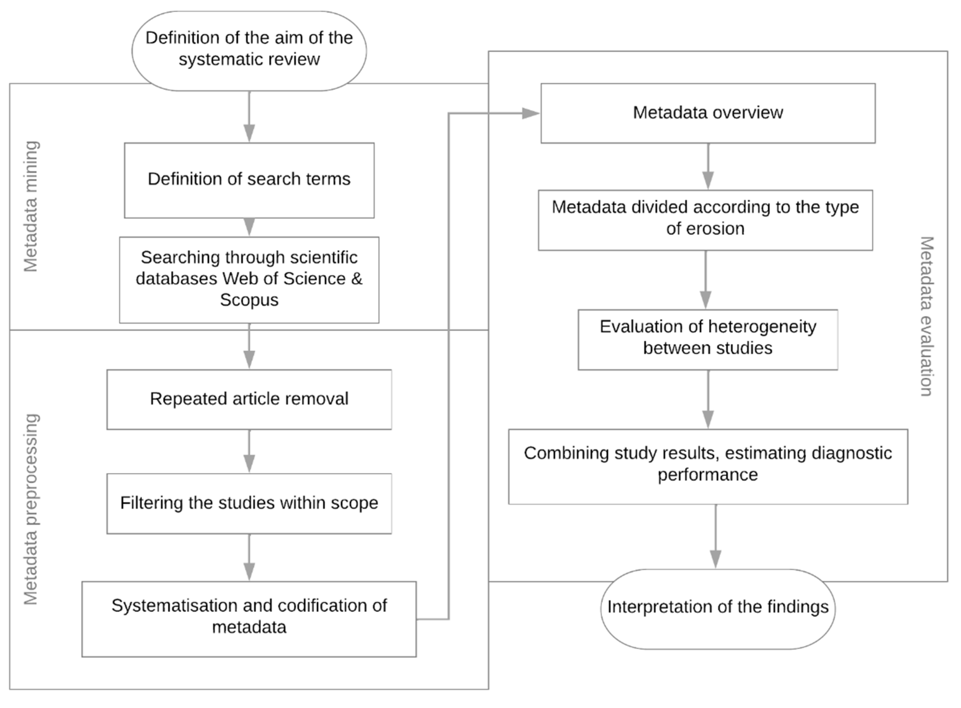
2. Materials and Methods

This systematic review is based on studies retrieved through an extensive literature search for peer-reviewed publications focusing on UAVs in soil and water erosion studies, as shown in Figure 1. The search used the Web of Science and Scopus databases, targeting articles published in English between January 2012 and December 2024, all open access.
The search strategy was refined to include only peer-reviewed articles. Search terms employed were: “monitoring” AND “erosion” AND “UAV”; “soil erosion” AND “UAV”; “monitoring” AND “soil erosion” AND “UAV”; and “monitoring” AND “erosion” AND “UAV” AND “soil”. This search initially yielded 473 articles.
The review incorporated bibliometric analysis, utilizing scientific mapping to explore the dynamics of the research topic. Key information extracted from the articles included authors, publication year and country, index terms, abstracts, journals, most impactful documents, types of UAVs and sensors used, and software for Structure-from-Motion (SfM) photogrammetry. These data were analyzed bibliometrically using the bibliometrix package in R [43,44]. Data mining techniques were also employed in R [45] with the pdftools and stringr packages to ensure relevance, remove redundancies, and focus on articles pertinent to monitoring degraded areas [46,47]. The selected articles were categorized based on the type of erosion studied. Duplicate articles were excluded, and only those containing the keywords and their synonyms—such as “rill”, “interrill”, “piping”, “gully”, and “mass displacement”—were retained, aligning with the study’s scope. This resulted in a final set of 304 articles focusing on terrain modeling with UAV images for erosion studies.
The kinship analysis of research topics was conducted using Euler diagrams in R [48]. Additionally, a co-occurrence analysis of terms was performed to explore conceptual structures within the research field [45]. This analysis used the VOSviewer 1.6.20 software [49]. Metadata were used to develop a co-occurrence map of terms based on their distances. Terms extracted from titles and abstracts were grouped and mapped according to their similarity matrix results, providing insights into the relationship between model evaluation concepts and the conceptual frameworks in the research [45].

3. Results and Discussion

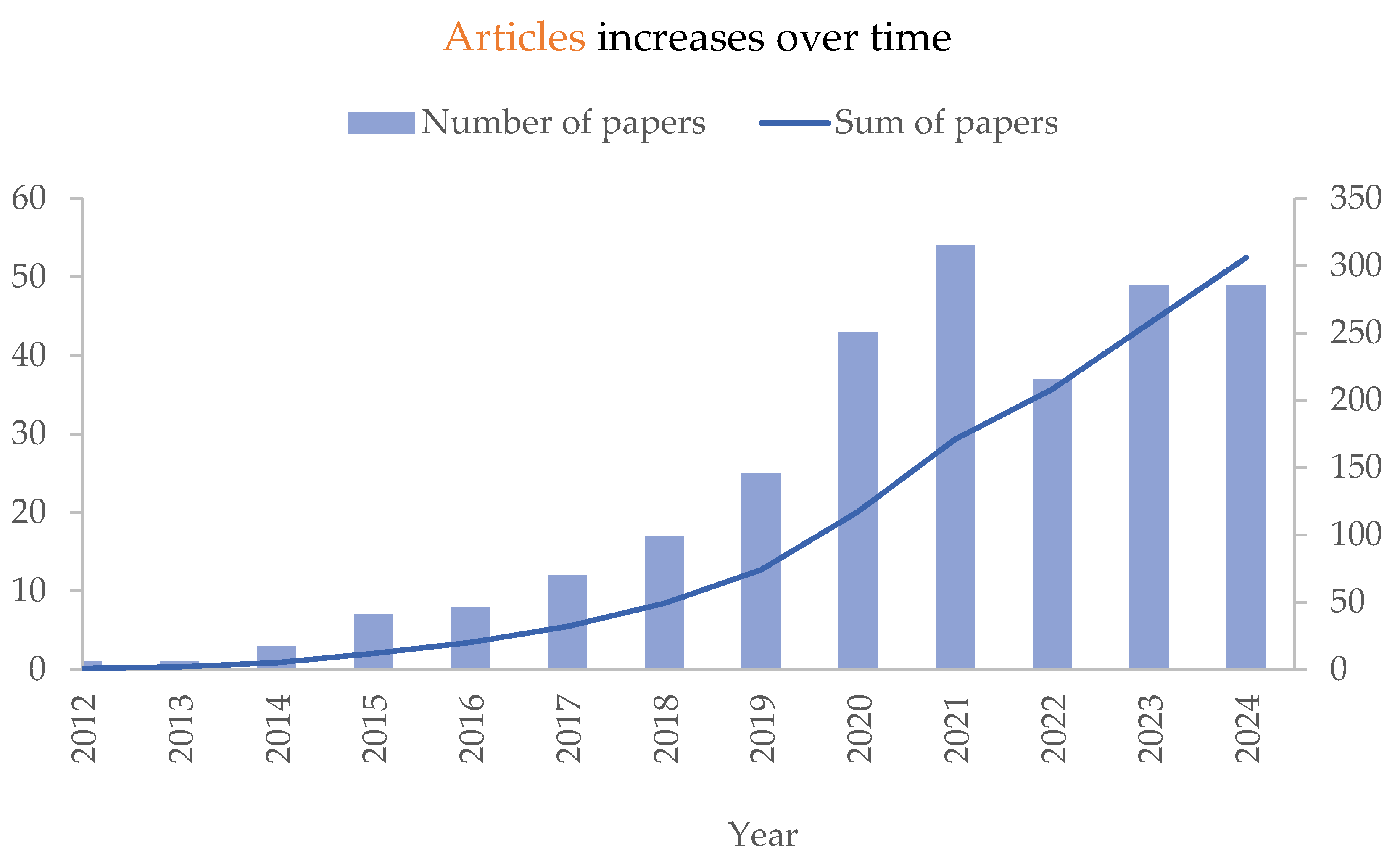
3.1. Overview of UAV Use in Soil Water Erosion Studies

The use of UAVs in water erosion studies has gained substantial momentum over the past decade, with a sharp increase in published research. From 2012 to 2024, 304 articles were published, highlighting the growing focus on UAV-based soil erosion monitoring (Figure 2).
This upward trend accelerated around 2018, peaking in 2021 with 54 published articles, with an annual growth rate of 5.48%. These articles showcased the expanding role of UAVs in the literature and the increasing attention paid to their applications in soil erosion studies.
The advancements in UAV technology have provided researchers with versatile and user-friendly tools for remote sensing, enabling a wide range of applications. UAVs have evolved into flexible resources for environmental monitoring, particularly in soil and water management. The use of UAV imagery dates back to 1990 in environmental biology, where it facilitated studies on vegetation, animal populations, and behavior [50]. In soil science, UAV applications emerged in the 21st century [51,52,53], though the precise date of their introduction remains uncertain.
In soil and water conservation, UAVs are employed for tasks such as early weed management [54], monitoring vegetation changes [55], and calculating erosion volumes [28,29,56], thereby improving erosion control planning. While challenges remain, UAVs offer georeferenced image data across diverse applications [57]. In geomorphology, UAVs enable detailed surface topography characterization, detecting elevation, location, and volume changes due to land surface processes. Their utility spans multiple fields and regions, providing high-resolution spatial and temporal data crucial for understanding and managing erosion dynamics.
Water erosion is recognized as the primary threat to soil ecosystem functions in five of the seven global regions [58]. This underscores the importance of regional studies in developing effective erosion control strategies. The geographical distribution of studies (Figure 3) reveals research disparities, particularly in underexplored regions like Africa and parts of Latin America, while also identifying areas where further studies are needed to fill existing knowledge gaps.
Most studies are concentrated in Europe (146 studies), Asia (85 studies, 62 in China), and America (53 studies). China’s focus on the Loess Plateau, an area with severe erosion issues [59], drives much of Asia’s research. Despite 37 countries being involved, Europe is showing improvement in erosion control [58]. Overall, 41 studies have been conducted in North America, with 32 conducted in the United States. South America, with 11 studies, is primarily represented by Brazil. With its vast land area, Africa has seen only 5 studies, mainly concentrated in South Africa, Morocco, and Tanzania [23,60,61]. Regions like Sub-Saharan Africa, South America, and Southeast Asia face increasing soil erosion pressures due to anthropogenic activity and land use change [62]. These areas are critical for future research efforts to develop sustainable soil management strategies.
UAVs have proven to be powerful tools in soil erosion monitoring due to their low cost, precision, and ability to provide high-resolution data [55,63,64,65,66]. Their capacity to monitor diffuse erosion in agricultural watersheds, where traditional methods are inadequate, highlights their value [67]. Moreover, UAVs have demonstrated superior accuracy in estimating sediment volumes behind check dams compared to conventional topographic surveys [68]. The increasing availability of remote sensing data and technological advancements has further driven UAV adoption in soil erosion research [69]. These advantages have made UAVs essential for erosion studies, particularly in regions with severe degradation, and have garnered growing attention from the scientific community over the last decade (Figure 2 and Figure 3).
Table 1 presents a ranking of the top 10 journals published on UAV-based soil erosion monitoring, based on the volume of publications and impact factors. Remote Sensing leads with 67 articles, establishing it as a primary outlet for this research focus. This aligns with the journal’s emphasis on remote sensing technologies, a key tool in UAV-based erosion studies.
Following Remote Sensing, journals like Earth Surface Processes and Landforms, ISPRS International Journal of Geo-Information, and Geomorphology indicate that a significant portion of the research integrates a geomorphological perspective, which is critical for understanding erosion processes. This trend underscores the relevance of earth surface science in UAV-based studies, where terrain and landform dynamics are key. The inclusion of journals such as Geoderma, Applied Sciences, Forests, and Land reflects a broader environmental approach, showing that UAV-based erosion research spans both environmental and soil science fields. This multidisciplinary relevance suggests that UAV technology applications in soil erosion are recognized across various scientific domains.
Table 2 presents the top 10 most cited articles on UAV-based soil erosion monitoring, ranked by total citation count, which ranges from 298 to 73. Notably, Eltner et al. (2016), D’Oleire-Oltmanns et al. (2012), and Smith and Vericat (2015) [23,31,68] received 368, 352, and 230 citations, respectively, making them the three most cited studies in the field (Table 2).
The studies presented in Table 2 underscore the significant impact of UAV technology on advancing soil erosion monitoring and geomorphology. Eltner et al. (2016) provided foundational insights into using SfM photogrammetry, detailing workflows and highlighting improvements in accuracy that make UAVs highly effective for high-resolution topographic analysis [31]. This work emphasized the potential of UAVs to capture fine details in terrain features, laying the groundwork for precise landscape monitoring. D’Oleire-Oltmanns et al. (2012) explore the use of UAVs as an innovative tool for soil erosion monitoring in vulnerable areas at Morroco, demonstrating how this technology can overcome the limitations of traditional methods [23]. Smith and Vericat (2015) expanded on this by demonstrating the scalability of UAV methods, showing how they can be applied to both small experimental plots and to larger, complex landscapes [68]. Their findings suggested that UAV-derived DEMs offer a comprehensive view of erosion processes, making UAVs valuable tools for studying geomorphic changes at various spatial scales. This work highlighted practical considerations, such as planning UAV deployments to ensure high-quality data coverage, which is crucial for broader applications.
The most influential documents illustrate UAV technology’s versatility and transformative potential in soil erosion research. By advancing high-resolution photogrammetry, demonstrating scalability across landscapes, and incorporating historical perspectives, these works collectively underscore that UAVs are indispensable tools for studying erosion dynamics, informing effective land management, and supporting sustainable environmental practices. It is important to note that while these influential studies have significantly shaped the field, their higher citation counts reflect both their historical impact and their importance, as newer advancements may also hold substantial value but have not yet accumulated comparable citations.

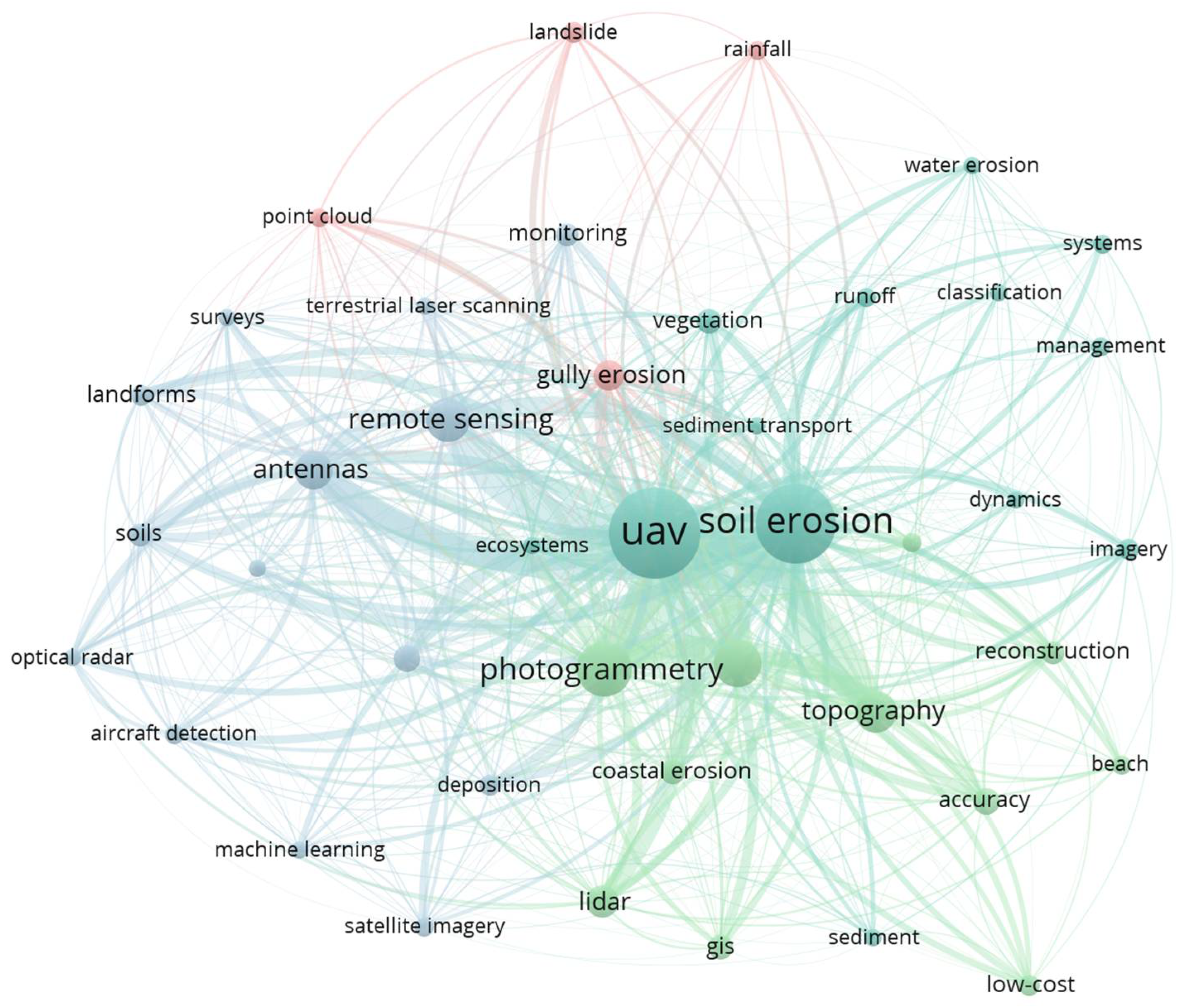
3.2. Study Topics in the Academic-Scientific World

Analyzing the research landscape of UAV applications in erosion-affected regions reveals four key research clusters, as shown in Figure 4. The co-occurrence map, generated from 2800 terms, highlights 42 key terms with relevance scores calculated using VOSviewer. The most prominent terms include “UAV”, “soil erosion”, and “photogrammetry”, reflecting the primary focus of this review.
The first cluster focuses on soil erosion processes, with terms like “water erosion”, “runoff”, and “sediment transport”, emphasizing the importance of spatial analysis and surface dynamics in identifying erosion patterns. The role of land use in influencing soil erosion is also highlighted, with studies suggesting the existence of increased erosion due to agricultural expansion [66], as is the impact of climate change, exacerbating erosion rates if no mitigation strategies are implemented [75,76].
The second cluster revolves around photogrammetry and the Structure-from-Motion (SfM) approach, featuring terms such as “topography”, “morphology”, and “reconstruction”. Introduced by Gafurov [77], SfM enables 3D surface interpretation from 2D projections, addressing the limitations of traditional methods like high costs and restricted mobility [31,78,79,80,81,82,83,84].
The third cluster emphasizes UAV advantages, particularly in terms of “low-cost” and “accuracy”, which are crucial for precision agriculture. UAVs provide a cost-effective alternative to traditional methods, offering high-resolution data at a fraction of the cost of ground-based surveys and satellite imagery [21,22]. When combined with SfM, UAVs generate high-resolution Digital Elevation Models (DEMs) and orthophotos, essential for quantifying soil loss and detecting erosion patterns at a centimeter scale [31,78]. This level of precision allows for targeted conservation practices, such as contour plowing and cover cropping, to mitigate erosion and improve land productivity [34,85]. Additionally, UAVs equipped with multispectral sensors can assess vegetation and soil moisture, offering valuable insights for erosion control [21,52]. However, it is important to emphasize that the accuracy and stability of UAV-derived data are critical factors. The effectiveness of UAVs can be influenced by various factors, including environmental conditions, sensor limitations, and errors in reconstruction algorithms. Ensuring high accuracy and consistency in data collection is essential for reliable erosion monitoring and analysis, particularly when multiple observations are required. Addressing these challenges is key to maximizing the potential of UAVs in soil erosion studies.
The fourth cluster addresses mass movement erosion, such as “landslide” and “gully erosion”, and focuses on advanced erosion forms with significant environmental impacts. The term “antennas” is present owing to their dual role in enhancing UAV communication and enabling high-precision georeferenced data collection. Antennas also facilitate mobile bases that detect ground movements, similar to RTK mobile stations, ensuring accurate spatial corrections and data collection in challenging terrains [80,86,87].

3.3. UAV-Based Soil Erosion Monitoring: Methodology and Technical Aspects

UAV-based soil erosion monitoring combines high-resolution remote sensing with advanced data processing to enhance accuracy and efficiency, overcoming the limitations of traditional field-based methods. This approach enables large-scale, repeatable, and precise data collection.
Monitoring begins with UAVs equipped with various sensors. RGB cameras create 3D terrain models [31], multispectral sensors assess vegetation health and soil moisture [81], and LiDAR sensors provide elevation data to detect small-scale erosion features like rills and gullies [82]. Key parameters in flight planning, such as altitude, image overlap (70–80%), and ground sampling distance (GSD), influence data quality and resolution [88]. Automated flight software and ground control points (GCPs) improve georeferencing accuracy [31].
After data acquisition, UAV imagery is processed using Structure-from-Motion (SfM) photogrammetry to create 3D terrain models, dense point clouds, and high-resolution Digital Elevation Models [31,56]. LiDAR processing generates Digital Terrain Models (DTMs) and Digital Surface Models (DSMs), which improve the detection of erosion features like gullies and rills [82,83]. Multispectral and thermal imagery is analyzed to calculate vegetation indices such as NDVI, essential for assessing vegetation cover and soil moisture, which impact erosion [81].
UAV-based data are crucial for detecting and quantifying erosion types. SfM photogrammetry can track gully formation and expansion in agricultural landscapes [84], while multi-temporal DEMs quantify soil elevation changes over time, offering insights into erosion rates [31]. UAVs are also effective in monitoring landslides, capturing high-resolution imagery before and after events to assess displacement and volume changes [86].
To improve accuracy, UAV data are combined with field measurements. Soil sampling provides crucial information on texture, moisture, and organic matter, influencing erosion susceptibility. Ground-based LiDAR and total stations validate UAV-derived DEMs, enhancing topographic precision [31].
In terms of UAV design, multi-rotor UAVs dominate, accounting for 89.8% of the studies reviewed, while fixed-wing UAVs make up only 10.2% of research (Figure 5).
UAV platforms are generally classified into two types: multi-rotor (e.g., quadcopters, hexacopters, and octocopters) and fixed-wing UAVs. These platforms differ in mobility, vertical takeoff and landing (VTOL) capabilities, flight duration, and payload capacity [89]. Multi-rotor UAVs are highly maneuverable and ideal for tasks requiring precise control, such as VTOL for close inspections in agricultural or environmental monitoring [90]. They are easy to operate, with simple takeoff/landing and autonomous flight support. However, their limited battery life restricts coverage when used for larger surveys [91,92].
In contrast, fixed-wing UAVs offer longer flight times and greater efficiency for large-area assessments in a single flight. They require larger landing areas and more skilled operation but are well-suited for extensive surveys [93,94]. In coastal cliff erosion studies, multi-rotors provide more accurate volume measurements due to their precise control [94].
Multi-rotor UAVs are known for their high accuracy in soil erosion studies, thanks to adaptable flight control, automation, and the integration of intelligent algorithms. These UAVs allow precise photo overlap and angle settings, ensuring repeatable flights. Additionally, they can carry a range of sensors, including RGB, multispectral, and thermal sensors, making them versatile in terms of soil condition analysis [89].
The effectiveness of UAVs in soil erosion modeling depends largely on the sensors they carry. Sensors like RGB cameras, multispectral, hyperspectral, LiDAR, and thermal cameras acquire high-resolution spatial and spectral data to detect changes in vegetation cover and soil topography. The success of UAV-based erosion studies depends on the sensor types onboard [89], with RGB, multispectral, hyperspectral, infrared, and LiDAR sensors frequently used for their unique monitoring capabilities (Figure 6).
Out of 304 publications reviewed, 260 specified the UAV sensor type, with LiDAR and RGB sensors being the most commonly used. RGB cameras are favored for their affordability and high resolution but can introduce noise in photogrammetric products, particularly when electronic shutters cause rolling shutter effects, compromising modeling accuracy [95,96]. Mechanical shutters are used to mitigate this. Despite their limitations in spectral index extraction [97,98], RGB sensors are widely used for soil disturbance quantification, water erosion monitoring, and vegetation cover analysis across various landscapes [24,85,99,100]. However, they are insufficient for in-depth studies, especially due to their inability to capture red-edge (RE) and near-infrared (NIR) bands, essential for comprehensive vegetation monitoring [101].
Multispectral sensors, capturing visible and NIR wavelengths, provide enhanced capabilities for assessing vegetation health and soil erosion control. These sensors enable non-destructive data extraction from crops and are commonly used to measure vegetation indices like NDVI. They offer better spectral resolution than RGB sensors, making them more suitable for detailed vegetation and soil health analysis, though they are still limited compared to hyperspectral systems in spectral range [89,101].
LiDAR, a powerful tool for high-resolution topographic modeling, provides precise elevation data essential for detecting erosion features like gullies and rills. Its narrow pulse width delivers accurate point cloud data, enabling fine topographic detail and centimeter-level accuracy [82,102]. LiDAR is particularly effective in hard-to-reach areas, allowing for the modeling of small-scale features and erosion-affected soils [102]. It can generate Digital Terrain Models (DTMs) from DEMs, which are vital for erosion modeling [103,104].
The achievement of high spatial resolution by LiDAR and RGB cameras is crucial for detecting small-scale erosion features, improving model accuracy, and enabling detailed topographic mapping. Advances in sensor technology continue to enhance this resolution, which is key for effective geomorphological analysis and soil conservation planning [105]. The choice of sensor and resolution should align with the study’s objectives, balancing detailed topographic data with broader spectral information.
Integrating advanced sensors like LiDAR, thermal, and infrared cameras has significantly improved UAV-based soil erosion studies. LiDAR’s high-resolution topographic models provide precision in identifying erosion features, while thermal cameras offer insights into soil moisture and vegetation stress, revealing areas more prone to erosion [106]. Infrared cameras, especially those capturing NIR wavelengths, complement LiDAR by providing detailed data on vegetation health, which plays a crucial role in preventing soil erosion [107].
The synergy of these sensors enables a holistic approach to soil erosion monitoring, improving the accuracy of erosion models and enhancing soil conservation strategies. By combining LiDAR data with thermal and infrared sensor information, researchers gain a comprehensive understanding of the relationship between vegetation cover and erosion patterns [108,109].
UAV photogrammetry, particularly using Structure-from-Motion (SfM) techniques, has become invaluable for monitoring soil erosion. SfM reconstructs high-resolution 3D models from overlapping images, essential for environmental monitoring and creating georeferenced DEMs [100,110,111]. The SfM workflow involves detecting features, aligning frames, and creating point clouds for accurate 3D models [112]. Figure 7 shows the SfM photogrammetry software used in the analyzed studies. Agisoft, the most cited tool, is preferred for its functionality in 3D modeling, though its paid license can increase processing costs [113].
Despite the advantages, UAV-based photogrammetry faces challenges in data processing, particularly in densely vegetated areas where ground features are obscured. Large datasets obtained from UAVs require advanced processing techniques, specialized software, and remote sensing expertise. Efficient processing workflows are critical to extract actionable insights from raw imagery [112,114]. The choice of software and UAV type should align with specific research objectives in soil erosion and geomorphological studies [115].
The integration of Geographic Information System (GIS) software technologies, such as QGIS, ArcGIS, and ENVI, plays a pivotal role in the post-processing and analysis of UAV-derived data for soil water erosion monitoring. While photogrammetry software (e.g., Pix4D, Agisoft Metashape) is primarily used for point cloud generation and 3D model reconstruction, GIS platforms are essential for advanced spatial analysis. These tools enable the handling of orthomosaics, the calculation of vegetation indices, the assessment of land cover changes, and the identification of erosion features of UAV-derived products with other datasets, including soil maps, climate data, and satellite imagery, to provide a more comprehensive understanding of erosion dynamics. This integration underscores the importance of GIS technologies in transforming ray UAV data into actionable insights for soil and water conservation.
Unlike conventional methods, UAV-based remote sensing enables sub-centimeter accuracy in topographic modeling while significantly reducing survey time and labor costs [115]. Current UAV systems integrate SfM with Multi-View Stereo (SfM-MVS) photogrammetry and RTK GPS georeferencing to achieve root mean square errors (RMSEs) as low as 3 mm in 3D point cloud reconstructions. This level of precision allows for the detailed quantification of key erosion parameters, such as sediment source contributions (89% mass movements, 8% rill and, 3% interrill erosion) and volumetric changes, with uncertainties ranging from ±6 to 276 mm using the Multiscale Model-to-Model Cloud Comparison (M3C2) algorithm [56].
Empirical studies demonstrate UAV-SfM’s robust performance across erosion processes: interrill erosion measurements achieve sub-centimeter precision (~2.2 mm; [28]), while rill and gully erosion analyses report RMSE values of 47–92 mm [116] and 0.03–3 mm [56,98], respectively. Machine learning enhances detection capabilities, with rill recognition rates of 80–90% on high-resolution DEMs [117]. For larger-scale features like landslides, centimeter-level accuracy persists (RMSE = 19 mm; [118]). Key determinants of accuracy include sensor resolution, GCPs density, and algorithmic rigor—studies employing stringent GCP protocols (e.g., [119], RMSE = 4–132 mm) underscore the necessity of using standardized methodologies for cross-study comparability and reliable erosion assessments.

3.4. UAV Application in Different Forms of Soil Water Erosion

Among the 304 publications analyzed, gullies were the most frequently studied type of erosion, appearing in 99 articles. Landslides were the second most common focus, with 82 articles dedicated to this topic. Rills were covered in 36 articles, while piping and interrill erosion were less frequently addressed, with 8 articles each (Figure 8). Some 23.4% of the studies did not specify the type of erosion investigated but indicated that the research involved soil degradation caused by erosion. Despite not classifying the erosion type, these studies have made notable contributions to the field and have been widely cited.

3.4.1. Gully Erosion

Gully erosion is a significant global issue of soil degradation. Research has extensively focused on monitoring, measuring, and analyzing the initiation and evolution of gullies over time and space [23,113,120,121,122]. Despite these efforts, further investigation is needed into the influence of rainfall on gully erosion across different temporal scales, including single and multiple events, extreme rainfall event periodicity, and antecedent moisture conditions [109].
Studies on gully erosion have covered a range of area sizes, from small-scale to large-scale environments, including degraded areas [120,123], agricultural lands [83,84,109,124,125,126,127,128,129], mining areas [130], and watersheds. Efficiently studying watersheds and contributing areas helps to understand soil movement and gully formation.
The authors were among the pioneers in using remote sensing to map and monitor gully erosion across various scales [24]. Their work effectively detected gullies and assessed the topographic parameters influencing gully distribution at the catchment scale, such as elevation, slope, and slope aspect. Additionally, a long-term study used historical aerial and UAV imagery to analyze changes in 46 gullies from 1959 to 2018 [131]. The results indicated that headcut retreat was the most significant factor, contributing 6.1 times more to gully expansion than sidewall retreat.

3.4.2. Landslide Erosion

Landslides involve the movement of large volumes of soil, often triggered by incisions at the base of sloping hills. Given their significant impact on the environment, particularly in urban areas, it is not surprising that landslides are the most extensively studied type of erosion [132]. Collecting and monitoring data from active landslides is crucial for predicting future occurrences and minimizing potential damage [133].
Recent research has advanced various aspects of landslide study. For instance, recent studies have focused on the dynamics of reservoir bank landslides and shoreline erosion in active zones [134], the detection and simulation of potential hazards in areas prone to landslides [135], and assessing landslides in degraded areas following erosion events [136]. Additionally, some studies propose coastal vulnerability methodologies that leverage UAV-derived data [137].
The analyzed literature offers valuable insights into the analysis, monitoring, spatiotemporal distribution, and susceptibility assessment of landslides [117,138]. Coastal areas [139,140,141], degraded regions [134,142,143], unpaved roads [141], urban environments [16,144], and agricultural areas are the primary focus of these studies.
Research in river basins is particularly relevant for understanding mass movement susceptibility, which is influenced by factors such as lithology, tectonics, and precipitation [136]. Such studies aid in risk forecasting, land use planning, and evaluating impacts on sediment production and river quality [145].
Challenges in studying landslides include process interactions, data analysis, and the accurate assessment of erosion mechanisms [142]. To address these challenges, researchers have developed susceptibility assessment approaches using high-resolution remote sensing data, including UAV photogrammetry, LiDAR, and SAR interferometry [146,147]. These methods help in analyzing the distribution, evolution, and volume of eroded soil and in formulating effective mitigation strategies.

3.4.3. Rill and Interrill Erosion

Interrill erosion, caused by the concentration of rainwater on minor surface irregularities, leads to shallow grooves or scratches on the soil. An efficient method for the precise and automated extraction of interrill erosion was developed by Eltner et al. [78].
UAVs are highly effective for identifying, quantifying, and predicting laminar erosion. Factors influencing this type of erosion include climate, time, soil properties, topography, land use, and management practices. The high spatial resolution of UAV images enables the detailed analysis of erosion patterns over time and space [28,148,149]. Most studies have been conducted in field settings, though one laboratory-based study also exists [138]. The research covered areas ranging from 18 m2 to 1,240,000 m2, highlighting the versatility of UAVs for both small- and large-scale analyses. These studies have been carried out in various environments, including natural soil conditions [28,78,149], agricultural lands [85], and watersheds [148].
For the accurate measurement of laminar erosion, multi-temporal Digital Elevation Models (DEMs) derived from UAVs are crucial [150]. Studies have examined slopes ranging from flat to strongly undulating terrain (0 to 23%), demonstrating the effectiveness of UAV methodologies across various topographies. Applying these methods to steeper terrain can save time and resources while providing high-quality results [151].
Research on rill erosion has focused on areas from 1.61 m2 to 700,000 m2, including badlands [39], catchment areas [152], unpaved roads [116,153], and agricultural fields [31,78,116,117,151,154]. UAV photogrammetry combined with SfM techniques allows for precise calculations of rill characteristics such as length, depth, cross-sectional area, and roughness [78]. Temporal comparisons of images enable the assessment of volumetric changes [78,151]. However, comparing absolute values across studies can be challenging due to variations in measurement methods and plot sizes [117].
Integrating data from multiple sensors can enhance the identification of topographic features. Some studies combined UAV-SfM approaches with terrestrial laser scanning (TLS), also known as high-resolution topography (HiRT), to improve soil loss measurement reliability [155]. These methods address the limitations of traditional techniques by providing detailed and accurate 3D models. Researchers employed SfM with post-processing kinematics (PPK) for precise, georeferenced positioning, enhancing fieldwork efficiency and reducing costs [156].
In agricultural fields, researchers discovered that interrill erosion contributes more significantly to soil loss than sheet erosion, with an average erosion volume of 0.03 to 0.07 m³ per interrill [78]. A seasonal net soil loss of 6700 m3 in a preservation area with fine-textured soil was found by Neugirg et al. [39], indicating an average annual surface lowering of 5.3 cm.

3.4.4. Piping Erosion

Piping erosion, also known as tunnel erosion, occurs when erosion progresses to a less permeable layer, causing the removal of fine particles from the more porous upper layer [157,158,159]. This type of erosion has been the focus of several studies, which have provided valuable insights into its processes and impacts [11,13,160,161]. Tunnel erosion can occur in virtually all climatic zones and soil types, significantly affecting landscape evolution by altering hydrology and slope stability. Key factors influencing the occurrence and magnitude of piping include climate, soil properties, topography, land use, and management practices [162]. Most studies have been conducted in agricultural and pasture regions, with a few focusing exclusively on pasture areas [163,164,165]. These studies often involve silty soils, which are more prone to tunnel erosion [126]. Higher slopes, ranging from 5% to 30% in these studies, contribute to the development of tunnel erosion.
Recent research has highlighted the benefits of combining UAV methodology with geophysical surveys for mapping tunnel networks and internal structures, enhancing the understanding of the erosive processes involved [162]. Additionally, various detection methods for subsurface tunnel formation have been reviewed. Machine learning algorithms have shown promise in predicting tunnel erosion susceptibility [11,164]. However, most detection methods are surface-based and may underestimate affected areas by up to 50% [11].
Tunnel erosion has been found to correlate with gully head cuts [11,164] and increased surface erosion [166]. Understanding tunnel erosion patterns in both natural and anthropogenic environments is crucial for assessing landform features and risk factors and developing preventative and predictive measures [167]. The quantitative representation of these patterns through statistical analysis can aid in effective management planning [11,164].
Studies often reveal that multiple types of erosion occur simultaneously. For instance, laminar erosion frequently evolves into furrow erosion, and many studies have examined both types of erosion, particularly in cultivated areas [78,85,138,168]. The limitations of current techniques in identifying rill erosion, arising due to its similarity to interrill erosion, were highlighted by Eltner et al. [31]. Researchers developed a high-precision method for extracting furrow erosion, but further research is needed to distinguish between intrinsic and extrinsic factors affecting soil surface changes over time [78].

3.5. Challenges and Opportunities

There is a significant gap in understanding the relationship between soil attributes and the occurrence of erosion processes, which is critical for effective soil conservation. While UAV-based monitoring provides valuable data on surface characteristics, it is limited in terms of directly extracting key soil parameters, such as soil classification, physical, morphological, and chemical attributes, which typically require the availability of surveys or direct sampling.
For example, studies on piping erosion have highlighted its prevalence in silt-rich soils [161,164,166], but detailed information on soil properties is often lacking. This gap hinders the development of robust, universally applicable methodologies. Dispersive and sodic soils, which are particularly prone to tunnel erosion [169], remain understudied, and critical soil properties like expansion, shrinkage, consolidation, compaction, and aggregate breakdown—vital for accurately characterizing laminar erosion—are rarely integrated into erosion models [170].
Addressing this challenge requires a concerted effort to collect and analyze soil data alongside erosion studies; leveraging advanced technologies like UAVs, LiDAR, and multispectral imaging can enhance our understanding of soil erosion dynamics. Bridging this knowledge gap will allow researchers to develop more effective conservation strategies, tailored to specific soil and landscape conditions, helping to mitigate erosion’s impacts on agriculture and the environment.
The analysis of soil erosion is essential for both environmental preservation and agricultural sustainability. UAVs, using SfM photogrammetry techniques, provide a novel approach for detailed soil erosion evaluation through orthophotos and high-resolution imagery [31]. However, this method faces significant challenges, such as data accuracy and integration. Variability in spatial resolution and sensor quality can compromise the reliability of collected data, necessitating ongoing advancements in technology. Additionally, the large-scale data collection process amplifies the need for precise information, while the effective harmonization of UAV, satellite, and ground sensor data is essential for comprehensive erosion analysis.
Field studies using UAVs also encounter challenges like vegetation cover, wind, lighting, and data ambiguities [94,171]. Researchers have proposed methods to enhance point cloud modeling by reducing vegetation noise and improving accuracy in erosion measurements for both natural and managed environments [172].
Despite these challenges, UAVs offer substantial opportunities. The near-real-time monitoring of erosion-prone areas enables swift responses to changes in soil conditions, leading to more effective prevention strategies. Technological advancements in UAVs, sensor integration, computer vision, artificial intelligence, and photogrammetry have significantly enhanced our understanding of erosive processes [31]. These advancements are improving soil and water conservation practices.
Recent trends in UAV-based soil erosion monitoring focus on integrating advanced sensors, automation, and scalable approaches to improve accuracy and efficiency. The combination of RGB, multispectral, hyperspectral, LiDAR, and thermal sensors has significantly enhanced erosion assessments. Integrating LiDAR-derived topographic data with multispectral vegetation indices allows for more precise evaluations of vegetation cover and erosion susceptibility, supporting better soil loss estimations and conservation planning [161].
Artificial intelligence and machine learning are transforming UAV-based erosion monitoring by automating the detection of features such as gullies and rills. These technologies process large UAV datasets faster and with greater accuracy than traditional methods [164]. Predictive models based on historical data and environmental variables further enhance early detection and mitigation efforts for erosion risk [166].
Near-real-time monitoring and data transmission allow the immediate detection of erosion events, especially in remote or inaccessible areas. UAVs equipped with real-time transmission capabilities provide instant feedback on landslides and gully formation, enabling rapid responses, particularly in regions affected by extreme weather events [169].
High-resolution 3D modeling has also advanced through techniques like 3D Gaussian Splatting (3DGS) and Neural Radiance Fields (NeRF). These methods enable the generation of highly detailed terrain models, offering significant improvements over traditional photogrammetric techniques. Studies have demonstrated how these technologies enhance soil surface reconstruction and erosion feature detection [56,60]. Furthermore, their application in geomorphological studies has proven invaluable for generating high-fidelity 3D models, which are essential for understanding erosion processes and developing effective mitigation strategies [172].
The integration of UAV data with satellite imagery and ground sensors has improved multiscale erosion monitoring. UAVs offer high-resolution local data, while satellite imagery provides broader spatial coverage. Ground sensors, such as soil moisture probes, help validate UAV-derived data, ensuring more accurate assessments of erosion dynamics [109]. These integrated models improve soil loss quantification and enhance the understanding of erosion processes [173], representing a significant advancement in the field. The performance of UAVs can be affected by a range of factors, such as environmental variables, sensor constraints, and inaccuracies in reconstruction algorithms. Achieving high precision and reliability in data acquisition is crucial for dependable erosion monitoring and analysis, especially in studies requiring multiple or repeated observations. Tackling these issues is vital to fully leveraging the capabilities of UAVs in soil erosion research.
Moreover, UAVs provide significant cost savings compared to traditional methods, making them especially beneficial for long-term studies or areas with challenging geographic conditions. In conclusion, while challenges related to data integration and process analysis remain, UAVs offer immense potential for advancing our understanding of erosion processes and improving soil management techniques.

4. Conclusions

This bibliometric analysis of UAV-based soil erosion monitoring offers valuable insights into the evolution and current state of this research field. The significant increase in research output underscores the growing role of UAVs in capturing detailed, spatially extensive data on soil erosion.
Advancements in UAV technology, particularly the integration of SfM photogrammetry and advanced sensor platforms, have greatly enhanced the precision and efficiency of monitoring soil erosion. However, challenges remain, particularly in ensuring data accuracy and integrating information from diverse sources, including UAVs, satellites, and ground sensors. Variations in spatial resolution and sensor quality can affect the reliability of the collected data, highlighting the need for continued improvements and methodological refinements.
Despite these challenges, UAVs present exciting opportunities for the near-real-time monitoring of erosion-prone areas, allowing for rapid responses to changes in soil conditions. The integration of UAVs with computer vision, artificial intelligence, and advanced photogrammetry techniques promises further advancements in soil and water conservation practices.
UAVs also offer cost savings compared to traditional methods, making them an attractive option for long-term studies and in regions with challenging geographical conditions. However, knowledge gaps remain, particularly regarding rill and interrill erosion, which have significant environmental impacts, such as gully formation, mass displacement, eutrophication, the siltation of water bodies, nutrient loss, and reductions in soil biodiversity.
A greater focus on integrating UAV-based erosion studies with data on intrinsic soil attributes—such as physical, morphological, and chemical properties—is essential. Combining data from UAVs, satellites, laser surveys, and field observations will provide a more comprehensive understanding of erosion processes, including laminar, gully, mass displacement, and piping erosion. Continued research and technological development are crucial to overcoming current challenges and maximizing the potential of UAVs in advancing soil erosion management.

Author Contributions

Conceptualization, B.M.M., B.C. and M.L.N.S.; methodology, B.M.M.; software, B.M.M.; validation, B.M.M., B.C. and M.L.N.S.; investigation, B.M.M. and P.A.J.J.; data curation, B.M.M.; writing—original draft preparation, B.M.M.; writing—review and editing, B.M.M., B.C., P.A.J.J., J.C.A. and M.L.N.S.; visualization, M.L.N.S. and B.C.; supervision, M.L.N.S., B.C. and J.C.A. All authors have read and agreed to the published version of the manuscript.

Funding

This work was supported in part by the Coordination of Improvement of Higher-Level Education Personnel—CAPES (process number 88887.569542/2020-00), the National Council for Scientific and Technological Development—CNPq (307950/2021-2) and the Foundation for Research Support of the State of Minas Gerais—FAPEMIG (APQ-00802-18).

Acknowledgments

The authors would like to express their sincere gratitude to the colleagues who contributed to the development of this research. Special thanks to Fernandes D.M., Cunha F.M., Osawa B.H.H., Souza D.B. and Silva V.L.C., this work would not have been possible without their unwavering support and commitment.

Conflicts of Interest

The authors declare no conflicts of interest. The funders had no role in the design of the study; in the collection, analyses, or interpretation of data; in the writing of the manuscript; or in the decision to publish the results.

References

  1. Kiani-Harchegani, M.; Najafi, S.; Ghahramani, A. Measuring and Mapping Excessive Linear Soil Erosion Features: Rills and Gullies. In Precipitation: Earth Surface Responses and Processes; Elsevier: Amsterdam, The Netherlands, 2021. [Google Scholar]
  2. Pimentel, D.; Harvey, C.; Resosudarmo, P.; Sinclair, K.; Kurz, D.; McNair, M.; Crist, S.; Shpritz, L.; Fitton, L.; Saffouri, R.; et al. Environmental and Economic Costs of Soil Erosion and Conservation Benefits. Science 1995, 267, 1117–1123. [Google Scholar] [CrossRef]
  3. Poesen, J. Soil Erosion in the Anthropocene: Research Needs. Earth Surf. Process Landf. 2018, 43, 64–84. [Google Scholar] [CrossRef]
  4. Borrelli, P.; Alewell, C.; Alvarez, P.; Anache, J.A.A.; Baartman, J.; Ballabio, C.; Bezak, N.; Biddoccu, M.; Cerdà, A.; Chalise, D.; et al. Soil Erosion Modelling: A Global Review and Statistical Analysis. Sci. Total Environ. 2021, 780, 146494. [Google Scholar] [CrossRef]
  5. Blaschke, P.M.; Trustrum, N.A.; Hicks, D.L. Impacts of Mass Movement Erosion on Land Productivity: A Review. Prog. Phys. Geogr. 2000, 24, 21–52. [Google Scholar] [CrossRef]
  6. Govers, G.; Giménez, R.; Van Oost, K. Rill Erosion: Exploring the Relationship between Experiments, Modelling and Field Observations. Earth Sci. Rev. 2007, 84, 87–102. [Google Scholar] [CrossRef]
  7. Guerra, A.J.T.; Fullen, M.A.; Jorge, M.D.C.O.; Bezerra, J.F.R.; Shokr, M.S. Slope Processes, Mass Movement and Soil Erosion: A Review. Pedosphere 2017, 27, 27–41. [Google Scholar] [CrossRef]
  8. Sun, L.; Fang, H.; Qi, D.; Li, J.; Cai, Q. A Review on Rill Erosion Process and Its Influencing Factors. Chin. Geogr. Sci. 2013, 23, 389–402. [Google Scholar] [CrossRef]
  9. Boix-Fayos, C.; Nadeu, E.; Quiñonero, J.M.; Martínez-Mena, M.; Almagro, M.; De Vente, J. Sediment Flow Paths and Associated Organic Carbon Dynamics across a Mediterranean Catchment. Hydrol. Earth Syst. Sci. 2015, 19, 1209–1223. [Google Scholar] [CrossRef]
  10. Valentin, C.; Poesen, J.; Li, Y. Gully Erosion: Impacts, Factors and Control. Catena 2005, 63, 132–153. [Google Scholar] [CrossRef]
  11. Kariminejad, N.; Hosseinalizadeh, M.; Pourghasemi, H.R.; Bernatek-Jakiel, A.; Campetella, G.; Ownegh, M. Evaluation of Factors Affecting Gully Headcut Location Using Summary Statistics and the Maximum Entropy Model: Golestan Province, NE Iran. Sci. Total Environ. 2019, 677, 281–298. [Google Scholar] [CrossRef]
  12. Kuhn, C.E.S.; Reis, F.A.G.V.; Lazaretti, A.F.; Zarfl, C.; Cabral, V.C.; Grathwohl, P. The Record and Trends of Natural Disasters Caused by Gullies in Brazil. Environ. Earth Sci. 2023, 82, 524. [Google Scholar] [CrossRef]
  13. Kariminejad, N.; Hosseinalizadeh, M.; Pourghasemi, H.R.; Tiefenbacher, J.P. Change Detection in Piping, Gully Head Forms, and Mechanisms. Catena 2021, 206, 105550. [Google Scholar] [CrossRef]
  14. Boardman, J.; Vandaele, K.; Evans, R.; Foster, I.D.L. Off-Site Impacts of Soil Erosion and Runoff: Why Connectivity Is More Important than Erosion Rates. Soil Use Manag. 2019, 35, 245–256. [Google Scholar] [CrossRef]
  15. Batista, P.V.G.; Davies, J.; Silva, M.L.N.; Quinton, J.N. On the Evaluation of Soil Erosion Models: Are We Doing Enough? Earth Sci. Rev. 2019, 197, 102898. [Google Scholar] [CrossRef]
  16. Šiljeg, A.; Domazetović, F.; Marić, I.; Lončar, N.; Panđa, L. New Method for Automated Quantification of Vertical Spatio-Temporal Changes within Gully Cross-Sections Based on Very-High-Resolution Models. Remote Sens. 2021, 13, 321. [Google Scholar] [CrossRef]
  17. Leh, M.; Bajwa, S.; Chaubey, I. IMPACT of Land Use Change on Erosion Risk: AN Integrated Remote Sensing, Geographic Information System and Modeling Methodology. Land. Degrad. Dev. 2013, 24, 409–421. [Google Scholar] [CrossRef]
  18. Sepuru, T.K.; Dube, T. An Appraisal on the Progress of Remote Sensing Applications in Soil Erosion Mapping and Monitoring. Remote Sens. Appl. 2018, 9, 1–9. [Google Scholar] [CrossRef]
  19. Moudden, F.; Hafyani, M.; El Ouali, A.; Roubil, A.; El Ouali, A.; Essahlaoui, A.; Brouziyne, Y. Diachronic Mapping and Evaluation of Soil Erosion Rates Using RUSLE in the Bouregreg River Watershed, Morocco. J. Water Land. Dev. 2022, 53, 86–99. [Google Scholar] [CrossRef]
  20. Olson, K.R.; Al-Kaisi, M.; Lal, R.; Cihacek, L. Impact of Soil Erosion on Soil Organic Carbon Stocks. J. Soil. Water Conserv. 2016, 71, 61A–67A. [Google Scholar] [CrossRef]
  21. Manfreda, S.; McCabe, M.F.; Miller, P.E.; Lucas, R.; Madrigal, V.P.; Mallinis, G.; Ben Dor, E.; Helman, D.; Estes, L.; Ciraolo, G.; et al. On the Use of Unmanned Aerial Systems for Environmental Monitoring. Remote Sens. 2018, 10, 641. [Google Scholar] [CrossRef]
  22. Harwin, S.; Lucieer, A. Assessing the Accuracy of Georeferenced Point Clouds Produced via Multi-View Stereopsis from Unmanned Aerial Vehicle (UAV) Imagery. Remote Sens. 2012, 4, 1573–1599. [Google Scholar] [CrossRef]
  23. D’Oleire-Oltmanns, S.; Marzolff, I.; Peter, K.D.; Ries, J.B. Unmanned Aerial Vehicle (UAV) for Monitoring Soil Erosion in Morocco. Remote Sens. 2012, 4, 3390–3416. [Google Scholar] [CrossRef]
  24. Mohebzadeh, H.; Biswas, A.; Rudra, R.; Daggupati, P. Machine Learning Techniques for Gully Erosion Susceptibility Mapping: A Review. Geosciences 2022, 12, 429. [Google Scholar] [CrossRef]
  25. Hänsel, P.; Kaiser, A.; Buchholz, A.; Böttcher, F.; Langel, S.; Schmidt, J.; Schindewolf, M. Mud Flow Reconstruction by Means of Physical Erosion Modeling, High-Resolution Radar-Based Precipitation Data, and Uav Monitoring. Geosciences 2018, 8, 427. [Google Scholar] [CrossRef]
  26. Chaudhary, S.; Wang, Y.; Dixit, A.M.; Khanal, N.R.; Xu, P.; Fu, B.; Yan, K.; Liu, Q.; Lu, Y.; Li, M. Spatiotemporal Degradation of Abandoned Farmland and Associated Eco-Environmental Risks in the High Mountains of the Nepalese Himalayas. Land 2020, 9, 1. [Google Scholar] [CrossRef]
  27. Hu, S.; Qiu, H.; Wang, N.; Cui, Y.; Wang, J.; Wang, X.; Ma, S.; Yang, D.; Cao, M. The Influence of Loess Cave Development upon Landslides and Geomorphologic Evolution: A Case Study from the Northwest Loess Plateau, China. Geomorphology 2020, 359, 107167. [Google Scholar] [CrossRef]
  28. Cândido, B.M.; Quinton, J.N.; James, M.R.; Silva, M.L.N.; de Carvalho, T.S.; de Lima, W.; Beniaich, A.; Eltner, A. High-Resolution Monitoring of Diffuse (Sheet or Interrill) Erosion Using Structure-from-Motion. Geoderma 2020, 375, 114477. [Google Scholar] [CrossRef]
  29. Junior, P.S.; Silva, M.L.N.; Cândido, B.M.; Avalos, F.A.P.; Batista, P.V.G.; Curi, N.; de Lima, W.; Quinton, J.N. Assessing Water Erosion Processes in Degraded Area Using Unmanned Aerial Vehicle Imagery. Rev. Bras. Cienc. Solo 2019, 43, e0190051. [Google Scholar] [CrossRef]
  30. Oh, S.; Chang, A.; Yang, J.E.; Kim, H.S.; Lim, K.J.; Jung, J. Recent Advances in UAS Based Soil Erosion Mapping. Mod. Concepts Dev. Agron. 2020, 7, 712–714. [Google Scholar] [CrossRef]
  31. Eltner, A.; Kaiser, A.; Castillo, C.; Rock, G.; Neugirg, F.; Abellán, A. Image-Based Surface Reconstruction in Geomorphometry-Merits, Limits and Developments. Earth Surf. Dyn. 2016, 4, 359–389. [Google Scholar] [CrossRef]
  32. Hackney, C.; Clayton, A.I. Unmanned Aerial Vehicles (UAVs) and Their Application in Geomorphic Mapping. In Geomorphological Techniques; Routledge: London, UK, 2015. [Google Scholar]
  33. Turner, D.; Lucieer, A.; Wallace, L. Direct Georeferencing of Ultrahigh-Resolution UAV Imagery. IEEE Trans. Geosci. Remote Sens. 2014, 52, 2738–2745. [Google Scholar] [CrossRef]
  34. Meinen, B.U.; Robinson, D.T. Streambank Topography: An Accuracy Assessment of UAV-Based and Traditional 3D Reconstructions. Int. J. Remote Sens. 2020, 41, 1–18. [Google Scholar] [CrossRef]
  35. Bezak, N.; Mikoš, M.; Borrelli, P.; Alewell, C.; Alvarez, P.; Anache, J.A.A.; Baartman, J.; Ballabio, C.; Biddoccu, M.; Cerdà, A.; et al. Soil Erosion Modelling: A Bibliometric Analysis. Environ. Res. 2021, 197, 111087. [Google Scholar] [CrossRef] [PubMed]
  36. Parag, M.; Lottering, R.; Peerbhay, K.; Agjee, N.; Poona, N. The Use of Synthetic Aperture Radar Technology for Crop Biomass Monitoring: A Systematic Review. Remote Sens. Appl. 2024, 33, 101107. [Google Scholar] [CrossRef]
  37. Raparelli, E.; Bajocco, S. A Bibliometric Analysis on the Use of Unmanned Aerial Vehicles in Agricultural and Forestry Studies. Int. J. Remote Sens. 2019, 40, 9070–9083. [Google Scholar] [CrossRef]
  38. Rejeb, A.; Abdollahi, A.; Rejeb, K.; Treiblmaier, H. Drones in Agriculture: A Review and Bibliometric Analysis. Comput. Electron. Agric. 2022, 198, 107017. [Google Scholar] [CrossRef]
  39. Neugirg, F.; Stark, M.; Kaiser, A.; Vlacilova, M.; Della Seta, M.; Vergari, F.; Schmidt, J.; Becht, M.; Haas, F. Erosion Processes in Calanchi in the Upper Orcia Valley, Southern Tuscany, Italy Based on Multitemporal High-Resolution Terrestrial LiDAR and UAV Surveys. Geomorphology 2016, 269, 8–22. [Google Scholar] [CrossRef]
  40. Bertalan, L.; Holb, I.; Pataki, A.; Négyesi, G.; Szabó, G.; Kupásné Szalóki, A.; Szabó, S. UAV-Based Multispectral and Thermal Cameras to Predict Soil Water Content—A Machine Learning Approach. Comput. Electron. Agric. 2022, 200, 107262. [Google Scholar] [CrossRef]
  41. Meinen, B.U.; Robinson, D.T. Mapping Erosion and Deposition in an Agricultural Landscape: Optimization of UAV Image Acquisition Schemes for SfM-MVS. Remote Sens. Environ. 2020, 239, 111666. [Google Scholar] [CrossRef]
  42. Bettoni, M.; Maerker, M.; Bosino, A.; Schillaci, C.; Vogel, S. Bibliometric Analysis of Soil and Landscape Stability, Sensitivity and Resistivity. Land 2022, 11, 1328. [Google Scholar] [CrossRef]
  43. Aria, M.; Cuccurullo, C. Bibliometrix: An R-Tool for Comprehensive Science Mapping Analysis. J. Informetr. 2017, 11, 959–975. [Google Scholar] [CrossRef]
  44. R Core Team. R: A Language and Environment for Statistical Computing; R Foundation for Statistical Computing: Vienna, Austria, 2019. [Google Scholar]
  45. Mora-Valentín, E.M.; Ortiz-de-Urbina-Criado, M.; Nájera-Sánchez, J.J. Mapping the Conceptual Structure of Science and Technology Parks. J. Technol. Transf. 2018, 43, 1410–1435. [Google Scholar] [CrossRef]
  46. Wickham, H. Ggplot2. Wiley Interdiscip. Rev. Comput. Stat. 2011, 3, 180–185. [Google Scholar] [CrossRef]
  47. Ooms, J. The Jsonlite Package: A Practical and Consistent Mapping Between JSON Data and R Objects. arXiv 2014, arXiv:1403.2805. [Google Scholar]
  48. Wickham, H.; Averick, M.; Bryan, J.; Chang, W.; McGowan, L.D.A.; François, R.; Yutani, H. Welcome to the tidyverse. J. Open Source Softw. 2019, 4, 1686. [Google Scholar] [CrossRef]
  49. van Eck, N.J.; Waltman, L. Software Survey: VOSviewer, a Computer Program for Bibliometric Mapping. Scientometrics 2010, 84, 523–538. [Google Scholar] [CrossRef]
  50. Nowak, M.M.; Dziób, K.; Bogawski, P. Unmanned Aerial Vehicles (UAVs) in Environmental Biology: A Review. Eur. J. Ecol. 2019, 4, 56–74. [Google Scholar] [CrossRef]
  51. Brevik, E.C.; Hartemink, A.E. Early Soil Knowledge and the Birth and Development of Soil Science. Catena 2010, 83, 23–33. [Google Scholar] [CrossRef]
  52. Pudelko, R.; Stuczynski, T.; Borzecka-Walker, M. The Suitability of an Unmanned Aerial Vehicle (UAV) for the Evaluation of Experimental Fields and Crops. Zemdirbyste 2012, 99, 431–436. [Google Scholar]
  53. Topp, G.C.; Davis, J.L.; Annan, A.P. Electromagnetic Determination of Soil Water Content: Measurements in Coaxial Transmission Lines. Water Resour. Res. 1980, 16, 574–582. [Google Scholar] [CrossRef]
  54. Torres-Sánchez, J.; López-Granados, F.; De Castro, A.I.; Peña-Barragán, J.M. Configuration and Specifications of an Unmanned Aerial Vehicle (UAV) for Early Site Specific Weed Management. PLoS ONE 2013, 8, e58210. [Google Scholar] [CrossRef] [PubMed]
  55. Rango, A.; Laliberte, A.; Herrick, J.E.; Winters, C.; Havstad, K.; Steele, C.; Browning, D. Unmanned Aerial Vehicle-Based Remote Sensing for Rangeland Assessment, Monitoring, and Management. J. Appl. Remote Sens. 2009, 3, 033542. [Google Scholar] [CrossRef]
  56. Cândido, B.M.; James, M.; Quinton, J.; de Lima, W.; Silva, M.L.N. Sediment Source and Volume of Soil Erosion in a Gully System Using UAV Photogrammetry. Rev. Bras. Cienc. Solo 2020, 44, e0200076. [Google Scholar] [CrossRef]
  57. Nex, F.; Remondino, F. UAV for 3D Mapping Applications: A Review. Appl. Geomat. 2014, 6, 1–15. [Google Scholar] [CrossRef]
  58. FAO; ITPS. Intergovernmental Technical Panel on Soils. Status of the World’s Soil Resources; FAO: Rome, Italy, 2015. [Google Scholar]
  59. Zhao, H.; Fang, X.; Ding, H.; Strobl, J.; Xiong, L.; Na, J.; Tang, G. Extraction of Terraces on the Loess Plateau from High-Resolution Dems and Imagery Utilizing Object-Based Image Analysis. ISPRS Int. J. Geoinf. 2017, 6, 157. [Google Scholar] [CrossRef]
  60. Kaiser, A.; Neugirg, F.; Rock, G.; Müller, C.; Haas, F.; Ries, J.; Schmidt, J. Small-Scale Surface Reconstruction and Volume Calculation of Soil Erosion in Complex Moroccan Gully Morphology Using Structure from Motion. Remote Sens. 2014, 6, 7050–7080. [Google Scholar] [CrossRef]
  61. Blake, W.H.; Kelly, C.; Wynants, M.; Patrick, A.; Lewin, S.; Lawson, J.; Nasolwa, E.; Page, A.; Nasseri, M.; Marks, C.; et al. Integrating Land-Water-People Connectivity Concepts across Disciplines for Co-Design of Soil Erosion Solutions. Land Degrad. Dev. 2021, 32, 3415–3430. [Google Scholar] [CrossRef]
  62. Borrelli, P.; Robinson, D.A.; Fleischer, L.R.; Lugato, E.; Ballabio, C.; Alewell, C.; Meusburger, K.; Modugno, S.; Schütt, B.; Ferro, V.; et al. An Assessment of the Global Impact of 21st Century Land Use Change on Soil Erosion. Nat. Commun. 2017, 8, 2013. [Google Scholar] [CrossRef]
  63. Bendig, J.; Bolten, A.; Bennertz, S.; Broscheit, J.; Eichfuss, S.; Bareth, G. Estimating Biomass of Barley Using Crop Surface Models (CSMs) Derived from UAV-Based RGB Imaging. Remote Sens. 2014, 6, 10395–10412. [Google Scholar] [CrossRef]
  64. Aasen, H.; Burkart, A.; Bolten, A.; Bareth, G. Generating 3D Hyperspectral Information with Lightweight UAV Snapshot Cameras for Vegetation Monitoring: From Camera Calibration to Quality Assurance. ISPRS J. Photogramm. Remote Sens. 2015, 108, 245–259. [Google Scholar] [CrossRef]
  65. Dash, J.P.; Watt, M.S.; Pearse, G.D.; Heaphy, M.; Dungey, H.S. Assessing Very High Resolution UAV Imagery for Monitoring Forest Health during a Simulated Disease Outbreak. ISPRS J. Photogramm. Remote Sens. 2017, 131, 1–14. [Google Scholar] [CrossRef]
  66. Pineux, N.; Lisein, J.; Swerts, G.; Bielders, C.L.; Lejeune, P.; Colinet, G.; Degré, A. Can DEM Time Series Produced by UAV Be Used to Quantify Diffuse Erosion in an Agricultural Watershed? Geomorphology 2017, 280, 122–136. [Google Scholar] [CrossRef]
  67. Rodrigues, M.; de la Riva, J.; Fotheringham, S. Modeling the Spatial Variation of the Explanatory Factors of Human-Caused Wildfires in Spain Using Geographically Weightedlogistic Regression. Appl. Geogr. 2014, 48, 52–63. [Google Scholar] [CrossRef]
  68. Smith, M.W.; Vericat, D. From Experimental Plots to Experimental Landscapes: Topography, Erosion and Deposition in Sub-Humid Badlands from Structure-from-Motion Photogrammetry. Earth Surf. Process Landf. 2015, 40, 1656–1671. [Google Scholar] [CrossRef]
  69. Stumpf, A.; Malet, J.P.; Allemand, P.; Ulrich, P. Surface Reconstruction and Landslide Displacement Measurements with Pléiades Satellite Images. ISPRS J. Photogramm. Remote Sens. 2014, 95, 1–12. [Google Scholar] [CrossRef]
  70. Stumpf, A.; Malet, J.P.; Kerle, N.; Niethammer, U.; Rothmund, S. Image-Based Mapping of Surface Fissures for the Investigation of Landslide Dynamics. Geomorphology 2013, 186, 12–27. [Google Scholar] [CrossRef]
  71. Laporte-Fauret, Q.; Marieu, V.; Castelle, B.; Michalet, R.; Bujan, S.; Rosebery, D. Low-Cost UAV for High-Resolution and Large-Scale Coastal Dune Change Monitoring Using Photogrammetry. J. Mar. Sci. Eng. 2019, 7, 63. [Google Scholar] [CrossRef]
  72. Zhang, H.; Aldana-Jague, E.; Clapuyt, F.; Wilken, F.; Vanacker, V.; Van Oost, K. Evaluating the Potential of Post-Processing Kinematic (PPK) Georeferencing for UAV-Based Structure-from-Motion (SfM) Photogrammetry and Surface Change Detection. Earth Surf. Dyn. 2019, 7, 807–827. [Google Scholar] [CrossRef]
  73. Lin, Y.C.; Cheng, Y.T.; Zhou, T.; Ravi, R.; Hasheminasab, S.M.; Flatt, J.E.; Troy, C.; Habib, A. Evaluation of UAV LiDAR for Mapping Coastal Environments. Remote Sens. 2019, 11, 2893. [Google Scholar] [CrossRef]
  74. Papakonstantinou, A.; Topouzelis, K.; Pavlogeorgatos, G. Coastline Zones Identification and 3D Coastal Mapping Using UAV Spatial Data. ISPRS Int. J. Geoinf. 2016, 5, 75. [Google Scholar] [CrossRef]
  75. Brunier, G.; Oiry, S.; Gruet, Y.; Dubois, S.F.; Barillé, L. Topographic Analysis of Intertidal Polychaete Reefs (Sabellaria Alveolata) at a Very High Spatial Resolution. Remote Sens. 2022, 14, 307. [Google Scholar] [CrossRef]
  76. Morgan, J.A.; Brogan, D.J.; Nelson, P.A. Application of Structure-from-Motion Photogrammetry in Laboratory Flumes. Geomorphology 2017, 276, 125–143. [Google Scholar] [CrossRef]
  77. Gafurov, A. The Methodological Aspects of Constructing a High-Resolution DEM of Large Territories Using Low-Cost UAVs on the Example of the Sarycum Aeolian Complex, Dagestan, Russia. Drones 2021, 5, 7. [Google Scholar] [CrossRef]
  78. Eltner, A.; Baumgart, P.; Maas, H.G.; Faust, D. Multi-Temporal UAV Data for Automatic Measurement of Rill and Interrill Erosion on Loess Soil. Earth Surf. Process Landf. 2015, 40, 741–755. [Google Scholar] [CrossRef]
  79. García-Ruiz, J.M.; Nadal-Romero, E.; Lana-Renault, N.; Beguería, S. Erosion in Mediterranean Landscapes: Changes and Future Challenges. Geomorphology 2013, 198, 20–36. [Google Scholar] [CrossRef]
  80. Federman, A.; Santana Quintero, M.; Kretz, S.; Gregg, J.; Lengies, M.; Ouimet, C.; Laliberte, J. UAV Photgrammetric Workflows: A Best Practice Guideline. Int. Arch.Photogramm. Remote Sens. Spat. Inf. Sci. 2017, 42, 237–244. [Google Scholar] [CrossRef]
  81. Casamitjana, M.; Torres-Madroñero, M.C.; Bernal-Riobo, J.; Varga, D. Soil Moisture Analysis by Means of Multispectral Images According to Land Use and Spatial Resolution on Andosols in the Colombian Andes. Appl. Sci. 2020, 10, 5540. [Google Scholar] [CrossRef]
  82. Tarolli, P. High-Resolution Topography for Understanding Earth Surface Processes: Opportunities and Challenges. Geomorphology 2014, 216, 295–312. [Google Scholar] [CrossRef]
  83. Wang, Q.; Tang, B.; Wang, K.; Shi, J.; Li, M. Evaluation of the Gully Erosion Susceptibility by Using UAV and Hybrid Models Based on Machine Learning. Soil Tillage Res. 2024, 244, 106218. [Google Scholar] [CrossRef]
  84. Koci, J.; Jarihani, B.; Leon, J.X.; Sidle, R.; Wilkinson, S.; Bartley, R. Assessment of UAV and Ground-Based Structure from Motion with Multi-View Stereo Photogrammetry in a Gullied Savanna Catchment. ISPRS Int. J. Geoinf. 2017, 6, 328. [Google Scholar] [CrossRef]
  85. Bazzoffi, P. Measurement of Rill Erosion through a New UAV-GIS Methodology. Ital. J. Agron. 2015, 10, 1–18. [Google Scholar] [CrossRef]
  86. Sun, J.; Yuan, G.; Song, L.; Zhang, H. Unmanned Aerial Vehicles (UAVs) in Landslide Investigation and Monitoring: A Review. Drones 2024, 8, 30. [Google Scholar] [CrossRef]
  87. Deng, L.; Mao, Z.; Li, X.; Hu, Z.; Duan, F.; Yan, Y. UAV-Based Multispectral Remote Sensing for Precision Agriculture: A Comparison between Different Cameras. ISPRS J. Photogramm. Remote Sens. 2018, 146, 124–136. [Google Scholar] [CrossRef]
  88. James, M.R.; Robson, S. Straightforward Reconstruction of 3D Surfaces and Topography with a Camera: Accuracy and Geoscience Application. J. Geophys. Res. Earth Surf. 2012, 117, 03017. [Google Scholar] [CrossRef]
  89. Cai, G.; Dias, J.; Seneviratne, L. Survey of Small-Scale Unmanned Aerial Vehicles: Recent Advances and Future Development Trends. In Unmanned Systems: Best of 10 Years; World Scientific Pub Co Inc.: Singapore, 2023. [Google Scholar]
  90. Mohsan, S.A.H.; Khan, M.A.; Noor, F.; Ullah, I.; Alsharif, M.H. Towards the Unmanned Aerial Vehicles (UAVs): A Comprehensive Review. Drones 2022, 6, 147. [Google Scholar] [CrossRef]
  91. Boon, M.A.; Drijfhout, A.P.; Tesfamichael, S. Comparison of a Fixed-Wing and Multi-Rotor UAV for Environmental Mapping Applications: A Case Study. Int. Arch. Photogramm. Remote Sens. Spat. Inf. Sci. 2017, 42, 47–54. [Google Scholar] [CrossRef]
  92. Gómez-Gutiérrez, Á.; De Sanjosé-Blasco, J.J.; Lozano-Parra, J.; Berenguer-Sempere, F.; De Matías-Bejarano, J. Does HDR Pre-Processing Improve the Accuracy of 3D Models Obtained by Means of Two Conventional SfM-MVS Software Packages? The Case of the Corral Del Veleta Rock Glacier. Remote Sens. 2015, 7, 10269–10294. [Google Scholar] [CrossRef]
  93. Zhou, Y.; Daakir, M.; Rupnik, E.; Pierrot-Deseilligny, M. A Two-Step Approach for the Correction of Rolling Shutter Distortion in UAV Photogrammetry. ISPRS J. Photogramm. Remote Sens. 2020, 160, 51–66. [Google Scholar] [CrossRef]
  94. Dandois, J.; Olano, M.; Ellis, E. Optimal Altitude, Overlap, and Weather Conditions for Computer Vision UAV Estimates of Forest Structure. Remote Sens. 2015, 7, 13895–13920. [Google Scholar] [CrossRef]
  95. Tsouros, D.C.; Bibi, S.; Sarigiannidis, P.G. A Review on UAV-Based Applications for Precision Agriculture. Information 2019, 10, 349. [Google Scholar] [CrossRef]
  96. Rebelo, C.; Nascimento, J. Measurement of Soil Tillage Using Uav High-Resolution 3d Data. Remote Sens. 2021, 13, 4336. [Google Scholar] [CrossRef]
  97. Pijl, A.; Reuter, L.E.H.; Quarella, E.; Vogel, T.A.; Tarolli, P. GIS-Based Soil Erosion Modelling under Various Steep-Slope Vineyard Practices. Catena 2020, 193, 104604. [Google Scholar] [CrossRef]
  98. Alfonso-Torreño, A.; Gómez-Gutiérrez, Á.; Schnabel, S. Dynamics of Erosion and Deposition in a Partially Restored Valley-Bottom Gully. Land 2021, 10, 62. [Google Scholar] [CrossRef]
  99. Kucharczyk, M.; Hugenholtz, C.H.; Zou, X. Uav–Lidar Accuracy in Vegetated Terrain. J. Unmanned Veh. Syst. 2018, 6, 212–234. [Google Scholar] [CrossRef]
  100. Niculiță, M.; Mărgărint, M.C.; Tarolli, P. Using UAV and LiDAR Data for Gully Geomorphic Changes Monitoring. In Developments in Earth Surface Processes; Elsevier: Amsterdam, The Netherlands, 2020; Volume 23. [Google Scholar]
  101. Colomina, I.; Molina, P. Unmanned Aerial Systems for Photogrammetry and Remote Sensing: A Review. ISPRS J. Photogramm. Remote Sens. 2014, 92, 79–97. [Google Scholar] [CrossRef]
  102. Cucchiaro, S.; Cavalli, M.; Vericat, D.; Crema, S.; Llena, M.; Beinat, A.; Marchi, L.; Cazorzi, F. Geomorphic Effectiveness of Check Dams in a Debris-Flow Catchment Using Multi-Temporal Topographic Surveys. Catena 2019, 174, 73–83. [Google Scholar] [CrossRef]
  103. Liao, J.; Zhou, J.; Yang, W. Comparing LiDAR and SfM Digital Surface Models for Three Land Cover Types. Open Geosci. 2021, 13, 497–504. [Google Scholar] [CrossRef]
  104. Jaboyedoff, M.; Oppikofer, T.; Abellán, A.; Derron, M.H.; Loye, A.; Metzger, R.; Pedrazzini, A. Use of LIDAR in Landslide Investigations: A Review. Nat. Hazards 2012, 61, 5–28. [Google Scholar] [CrossRef]
  105. Yokoya, N.; Grohnfeldt, C.; Chanussot, J. Hyperspectral and Multispectral Data Fusion: A Comparative Review of the Recent Literature. IEEE Geosci. Remote Sens. Mag. 2017, 5, 29–56. [Google Scholar] [CrossRef]
  106. Cavalli, M.; Trevisani, S.; Comiti, F.; Marchi, L. Geomorphometric Assessment of Spatial Sediment Connectivity in Small Alpine Catchments. Geomorphology 2013, 188, 31–41. [Google Scholar] [CrossRef]
  107. Jones, H.G.; Leinonen, I. Thermal Imaging for the Study of Plant Water Relations. J. Agric. Meteorol. 2003, 59, 205–217. [Google Scholar] [CrossRef]
  108. Ishimwe, R.; Abutaleb, K.; Ahmed, F. Applications of Thermal Imaging in Agriculture—A Review. Adv. Remote Sens. 2014, 03, 128–140. [Google Scholar] [CrossRef]
  109. Wang, J.; Yang, J.; Li, Z.; Ke, L.; Li, Q.; Fan, J.; Wang, X. Research on Soil Erosion Based on Remote Sensing Technology: A Review. Agriculture 2024, 15, 18. [Google Scholar] [CrossRef]
  110. James, M.R.; Robson, S.; d’Oleire-Oltmanns, S.; Niethammer, U. Optimising UAV Topographic Surveys Processed with Structure-from-Motion: Ground Control Quality, Quantity and Bundle Adjustment. Geomorphology 2017, 280, 51–66. [Google Scholar] [CrossRef]
  111. Jones, A.F.; Brewer, P.A.; Johnstone, E.; Macklin, M.G. High-Resolution Interpretative Geomorphological Mapping of River Valley Environments Using Airborne LiDAR Data. Earth Surf. Process Landf. 2007, 32, 1574–1592. [Google Scholar] [CrossRef]
  112. Senanayake, S.; Pradhan, B.; Huete, A.; Brennan, J. A Review on Assessing and Mapping Soil Erosion Hazard Using Geo-Informatics Technology for Farming System Management. Remote Sens. 2020, 12, 4063. [Google Scholar] [CrossRef]
  113. Eltner, A.; Sofia, G. Structure from Motion Photogrammetric Technique. In Developments in Earth Surface Processes; Elsevier: Amsterdam, The Netherlands, 2020; Volume 23. [Google Scholar]
  114. Alexiou, S.; Papanikolaou, I.; Schneiderwind, S.; Kehrle, V.; Reicherter, K. Monitoring and Quantifying Soil Erosion and Sedimentation Rates in Centimeter Accuracy Using UAV-Photogrammetry, GNSS, and t-LiDAR in a Post-Fire Setting. Remote Sens. 2024, 16, 802. [Google Scholar] [CrossRef]
  115. Carollo, F.G.; Di Stefano, C.; Ferro, V.; Pampalone, V. Measuring rill erosion at plot scale by a drone-based technology. Hydrol. Process 2015, 29, 3802–3811. [Google Scholar] [CrossRef]
  116. Gioia, D.; Amodio, A.M.; Maggio, A.; Sabia, C.A. Impact of Land Use Changes on the Erosion Processes of a Degraded Rural Landscape: An Analysis Based on High-Resolution DEMs, Historical Images, and Soil Erosion Models. Land 2021, 10, 673. [Google Scholar] [CrossRef]
  117. Malinowski, R.; Heckrath, G.; Rybicki, M.; Eltner, A. Mapping Rill Soil Erosion in Agricultural Fields with UAV-Borne Remote Sensing Data. Earth Surf. Process Landf. 2023, 48, 596–612. [Google Scholar] [CrossRef]
  118. Kovanič, L’.; Blistan, P.; Urban, R.; Štroner, M.; Blišťanová, M.; Bartoš, K.; Pukanská, K. Analysis of the Suitability of High-Resolution DEM Obtained Using ALS and UAS (SfM) for the Identification of Changes and Monitoring the Development of Selected Geohazards in the Alpine Environment—A Case Study in High Tatras, Slovakia. Remote Sens. 2020, 12, 3901. [Google Scholar] [CrossRef]
  119. Glendell, M.; McShane, G.; Farrow, L.; James, M.R.; Quinton, J.; Anderson, K.; Evans, M.; Benaud, P.; Rawlins, B.; Morgan, D.; et al. Testing the Utility of Structure-from-Motion Photogrammetry Reconstructions Using Small Unmanned Aerial Vehicles and Ground Photography to Estimate the Extent of Upland Soil Erosion. Earth Surf. Process Landf. 2017, 42, 1860–1871. [Google Scholar] [CrossRef]
  120. le Roux, J.; Morake, L.; van der Waal, B.; Leigh Anderson, R.; Hedding, D.W. Intra-Gully Mapping of the Largest Documented Gully Network in South Africa Using UAV Photogrammetry: Implications for Restoration Strategies. Prog. Phys. Geogr. 2022, 46, 772–789. [Google Scholar] [CrossRef]
  121. Smith, P.; House, J.I.; Bustamante, M.; Sobocká, J.; Harper, R.; Pan, G.; West, P.C.; Clark, J.M.; Adhya, T.; Rumpel, C.; et al. Global Change Pressures on Soils from Land Use and Management. Glob. Chang. Biol. 2016, 22, 1008–1028. [Google Scholar] [CrossRef]
  122. Stöcker, C.; Eltner, A.; Karrasch, P. Measuring Gullies by Synergetic Application of UAV and Close Range Photogrammetry—A Case Study from Andalusia, Spain. Catena 2015, 132, 1–11. [Google Scholar] [CrossRef]
  123. Julian, C.; Nunes, J.O.R. Use of Uav and Gis for Eroded Soil Calculation on a Gully Located in the Amadeu Amaral District, in Marília, Sp—Brazil. Rev. Bras. Geomorfol. 2020, 21, 835–845. [Google Scholar] [CrossRef]
  124. Castillo, C.; Pérez, R.; James, M.R.; Quinton, J.N.; Taguas, E.V.; Gómez, J.A. Comparing the Accuracy of Several Field Methods for Measuring Gully Erosion. Soil. Sci. Soc. Am. J. 2012, 76, 1319–1332. [Google Scholar] [CrossRef]
  125. Castillo, C.; James, M.R.; Redel-Macías, M.D.; Pérez, R.; Gómez, J.A. SF3M Software: 3-D Photo-Reconstruction for Non-Expert Users and Its Application to a Gully Network. SOIL 2015, 1, 583–594. [Google Scholar] [CrossRef]
  126. Frankl, A.; Poesen, J.; Scholiers, N.; Jacob, M.; Haile, M.; Deckers, J.; Nyssen, J. Factors Controlling the Morphology and Volume (V)–Length (L) Relations of Permanent Gullies in the Northern Ethiopian Highlands. Earth Surf. Process Landf. 2013, 38, 1672–1684. [Google Scholar] [CrossRef]
  127. Xia, L.; Bi, R.; Song, X.; Lv, C. Dynamic Changes in Soil Erosion Risk and Its Driving Mechanism: A Case Study in the Loess Plateau of China. Eur. J. Soil. Sci. 2021, 72, 1312–1331. [Google Scholar] [CrossRef]
  128. Churu, H.; Kamau, S.; Ng’etich, W.; Magiroi, K.; Alkamoi, B.; Kebeney, S.; Wamalwa, F.; Mumo, J. Drivers of Gully Erosion and Its Socio-Economic and Environmental Effects in a Tropical Semi-Arid Environment. Asian J. Soil. Sci. Plant Nutr. 2024, 10, 13–26. [Google Scholar] [CrossRef]
  129. Mirzaee, S.; Pajouhesh, M.; Imaizumi, F.; Abdollahi, K.; Gomez, C. Gully Erosion Development during an Extreme Flood Event Using UAV Photogrammetry in an Arid Area, Iran. Catena 2024, 246, 108347. [Google Scholar] [CrossRef]
  130. Johansen, K.; Erskine, P.D.; McCabe, M.F. Using Unmanned Aerial Vehicles to Assess the Rehabilitation Performance of Open Cut Coal Mines. J. Clean. Prod. 2019, 209, 819–833. [Google Scholar] [CrossRef]
  131. Guan, Y.; Yang, S.; Zhao, C.; Lou, H.; Chen, K.; Zhang, C.; Wu, B. Monitoring Long-Term Gully Erosion and Topographic Thresholds in the Marginal Zone of the Chinese Loess Plateau. Soil Tillage Res. 2021, 205, 104800. [Google Scholar] [CrossRef]
  132. Larsen, I.J.; Montgomery, D.R.; Korup, O. Landslide Erosion Controlled by Hillslope Material. Nat. Geosci. 2010, 3, 247–251. [Google Scholar] [CrossRef]
  133. Frodella, W.; Ciampalini, A.; Bardi, F.; Salvatici, T.; Di Traglia, F.; Basile, G.; Casagli, N. A Method for Assessing and Managing Landslide Residual Hazard in Urban Areas. Landslides 2018, 15, 183–197. [Google Scholar] [CrossRef]
  134. Yermolaev, O.; Usmanov, B.; Gafurov, A.; Poesen, J.; Vedeneeva, E.; Lisetskii, F.; Nicu, I.C. Assessment of Shoreline Transformation Rates and Landslide Monitoring on the Bank of Kuibyshev Reservoir (Russia) Using Multi-Source Data. Remote Sens. 2021, 13, 4214. [Google Scholar] [CrossRef]
  135. Metternicht, G.; Hurni, L.; Gogu, R. Remote Sensing of Landslides: An Analysis of the Potential Contribution to Geo-Spatial Systems for Hazard Assessment in Mountainous Environments. Remote Sens. Environ. 2005, 98, 284–303. [Google Scholar] [CrossRef]
  136. Hussain, Y.; Schlögel, R.; Innocenti, A.; Hamza, O.; Iannucci, R.; Martino, S.; Havenith, H.B. Review on the Geophysical and UAV-Based Methods Applied to Landslides. Remote Sens. 2022, 14, 4564. [Google Scholar] [CrossRef]
  137. Ružić, I.; Jovančević, S.D.; Benac, Č.; Krvavica, N. Assessment of the Coastal Vulnerability Index in an Area of Complex Geological Conditions on the Krk Island, Northeast Adriatic Sea. Geosciences 2019, 9, 219. [Google Scholar] [CrossRef]
  138. Hsieh, Y.C.; Chan, Y.C.; Hu, J.C. Digital Elevation Model Differencing and Error Estimation from Multiple Sources: A Case Study from the Meiyuan Shan Landslide in Taiwan. Remote Sens. 2016, 8, 199. [Google Scholar] [CrossRef]
  139. Turner, I.L.; Harley, M.D.; Drummond, C.D. UAVs for Coastal Surveying. Coast. Eng. 2016, 114, 19–24. [Google Scholar] [CrossRef]
  140. Horacio, J.; Muñoz-Narciso, E.; Trenhaile, A.S.; Pérez-Alberti, A. Remote Sensing Monitoring of a Coastal-Valley Earthflow in Northwestern Galicia, Spain. Catena 2019, 178, 276–287. [Google Scholar] [CrossRef]
  141. Carabassa, V.; Montero, P.; Alcañiz, J.M.; Padró, J.C. Soil Erosion Monitoring in Quarry Restoration Using Drones. Minerals 2021, 11, 949. [Google Scholar] [CrossRef]
  142. Deligiannakis, G.; Pallikarakis, A.; Papanikolaou, I.; Alexiou, S.; Reicherter, K. Detecting and Monitoring Early Post-Fire Sliding Phenomena Using Uav–Sfm Photogrammetry and t-Lidar-Derived Point Clouds. Fire 2021, 4, 87. [Google Scholar] [CrossRef]
  143. Tak, W.J.; Jun, K.W.; Kim, S.D.; Lee, H.J. Using Drone and LiDAR to Assess Coastal Erosion and Shoreline Change due to the Construction of Coastal Structures. J. Coast. Res. 2020, 95, 674–678. [Google Scholar] [CrossRef]
  144. Sestras, P.; Bilașco, Ș.; Roșca, S.; Dudic, B.; Hysa, A.; Spalević, V. Geodetic and UAV Monitoring in the Sustainable Management of Shallow Landslides and Erosion of a Susceptible Urban Environment. Remote Sens. 2021, 13, 385. [Google Scholar] [CrossRef]
  145. Hemmelder, S.; Marra, W.; Markies, H.; De Jong, S.M. Monitoring River Morphology & Bank Erosion Using UAV Imagery—A Case Study of the River Buëch, Hautes-Alpes, France. Int. J. Appl. Earth Obs. Geoinf. 2018, 73, 428–437. [Google Scholar] [CrossRef]
  146. Sestras, P.; Badea, G.; Badea, A.C.; Salagean, T.; Oniga, V.-E.; Roșca, S.; Bilașco, Ș.; Bruma, S.; Spalević, V.; Kader, S.; et al. A Novel Method for Landslide Deformation Monitoring by Fusing UAV Photogrammetry and LiDAR Data Based on Each Sensor’s Mapping Advantage in Regards to Terrain Feature. Eng. Geol. 2025, 346, 107890. [Google Scholar] [CrossRef]
  147. Akay, S.S.; Özcan, O.; Şanlı, F.B.; Görüm, T.; Şen, Ö.L.; Bayram, B. UAV-Based Evaluation of Morphological Changes Induced by Extreme Rainfall Events in Meandering Rivers. PLoS ONE 2020, 15, e0241293. [Google Scholar] [CrossRef]
  148. Zhang, Y.; Xiong, J.; Hao, L. Photogrammetric Processing of Low-Altitude Images Acquired by Unpiloted Aerial Vehicles. Photogramm. Rec. 2011, 26, 190–211. [Google Scholar] [CrossRef]
  149. Chang, K.J.; Tseng, C.W.; Tseng, C.M.; Liao, T.C.; Yang, C.J. Application of Unmanned Aerial Vehicle (Uav)-Acquired Topography for Quantifying Typhoon-Driven Landslide Volume and Its Potential Topographic Impact on Rivers in Mountainous Catchments. Appl. Sci. 2020, 10, 6102. [Google Scholar] [CrossRef]
  150. Eltner, A.; Kaiser, A.; Abellan, A.; Schindewolf, M. Time Lapse Structure-from-Motion Photogrammetry for Continuous Geomorphic Monitoring. Earth Surf. Process Landf. 2017, 42, 2240–2253. [Google Scholar] [CrossRef]
  151. Di Stefano, C.; Palmeri, V.; Pampalone, V. An Automatic Approach for Rill Network Extraction to Measure Rill Erosion by Terrestrial and Low-Cost Unmanned Aerial Vehicle Photogrammetry. Hydrol. Process 2019, 33, 1883–1895. [Google Scholar] [CrossRef]
  152. Kou, P.; Xu, Q.; Yunus, A.P.; Ju, Y.; Guo, C.; Wang, C.; Zhao, K. Multi-Temporal UAV Data for Assessing Rapid Rill Erosion in Typical Gully Heads on the Largest Tableland of the Loess Plateau, China. Bull. Eng. Geol. Environ. 2020, 79, 1861–1877. [Google Scholar] [CrossRef]
  153. Zhang, Y.; Zhao, Y.; Liu, B.; Wang, Z.; Zhang, S. Rill and Gully Erosion on Unpaved Roads under Heavy Rainfall in Agricultural Watersheds on China’s Loess Plateau. Agric. Ecosyst. Environ. 2019, 284, 106580. [Google Scholar] [CrossRef]
  154. Alexiou, S.; Deligiannakis, G.; Pallikarakis, A.; Papanikolaou, I.; Psomiadis, E.; Reicherter, K. Comparing High Accuracy T-Lidar and UAV-SfM Derived Point Clouds for Geomorphological Change Detection. ISPRS Int. J. Geoinf. 2021, 10, 367. [Google Scholar] [CrossRef]
  155. Nakata, Y.; Iwasaki, K.; Shimoda, S.; Torita, H. Understanding Microtopography Changes in Agricultural Landscapes through Precision Assessments of Digital Surface Models by the UAV-RTK-PPK Method without Ground Control Points. Smart Agric. Technol. 2023, 5, 53–61. [Google Scholar] [CrossRef]
  156. Masannat, Y.M. Development of Piping Erosion Conditions in the Benson Area, Arizona, U.S.A. Q. J. Eng. Geol. 1980, 13, 53–61. [Google Scholar] [CrossRef]
  157. Hagerty, D.J. Piping/Sapping Erosion. I: Basic Considerations. J. Hydraul. Eng. 1991, 117, 991–1008. [Google Scholar] [CrossRef]
  158. Hagerty, D.J. Piping/Sapping Erosion. II: Identification-Diagnosis. J. Hydraul. Eng. 1991, 117, 1009–1025. [Google Scholar] [CrossRef]
  159. Kariminejad, N.; Hosseinalizadeh, M.; Pourghasemi, H.R.; Bernatek-Jakiel, A.; Alinejad, M. GIS-Based Susceptibility Assessment of the Occurrence of Gully Headcuts and Pipe Collapses in a Semi-Arid Environment: Golestan Province, NE Iran. Land. Degrad. Dev. 2019, 30, 2211–2225. [Google Scholar] [CrossRef]
  160. Hosseinalizadeh, M.; Kariminejad, N.; Campetella, G.; Jalalifard, A.; Alinejad, M. Spatial Point Pattern Analysis of Piping Erosion in Loess-Derived Soils in Golestan Province, Iran. Geoderma 2018, 328, 20–29. [Google Scholar] [CrossRef]
  161. Bernatek-Jakiel, A.; Poesen, J. Subsurface Erosion by Soil Piping: Significance and Research Needs. Earth Sci. Rev. 2018, 185, 1107–1128. [Google Scholar] [CrossRef]
  162. Kariminejad, N.; Pourghasemi, H.R.; Maleki, S.; Hosseinalizadeh, M. Digital Soil Mapping and Modeling in Loess-derived Soils of Iranian Loess Plateau. Geocarto Int. 2022, 37, 11633–11651. [Google Scholar] [CrossRef]
  163. Kariminejad, N.; Shariati, M.; Hosseinalizadeh, M.; Pourghasemi, H.R.; Maleki, S. Investigating Geometrical Characteristics of Collapsed Pipes and the Changing Role of Driving Factors. J. Environ. Manag. 2022, 312, 114910. [Google Scholar] [CrossRef]
  164. Kariminejad, N.; Hosseinalizadeh, M.; Pourghasemi, H.R.; Ownegh, M.; Rossi, M.; Tiefenbacher, J.P. Optimizing Collapsed Pipes Mapping: Effects of DEM Spatial Resolution. Catena 2020, 187, 104344. [Google Scholar] [CrossRef]
  165. Hosseinalizadeh, M.; Kariminejad, N.; Alinejad, M. An Application of Different Summary Statistics for Modelling Piping Collapses and Gully Headcuts to Evaluate Their Geomorphological Interactions in Golestan Province, Iran. Catena 2018, 171, 613–621. [Google Scholar] [CrossRef]
  166. Li, S.C.; Wu, J. A Multi-Factor Comprehensive Risk Assessment Method of Karst Tunnels and Its Engineering Application. Bull. Eng. Geol. Environ. 2019, 78, 1761–1776. [Google Scholar] [CrossRef]
  167. Kou, P.; Xu, Q.; Yunus, A.P.; Dong, X.; Pu, C.; Zhang, X.; Jin, Z. Micro-Topographic Assessment of Rill Morphology Highlights the Shortcomings of Current Protective Measures in Loess Landscapes. Sci. Total Environ. 2020, 737, 139721. [Google Scholar] [CrossRef]
  168. Nahlieli, A.; Svoray, T.; Argaman, E. Piping Formation and Distribution in the Semi-Arid Northern Negev Environment: A New Conceptual Model. Catena 2022, 213, 106201. [Google Scholar] [CrossRef]
  169. Boucher, S.C.; Powell, J.M. Gullying and Tunnel Erosion in Victoria. Aust. Geogr. Stud. 1994, 32, 17–26. [Google Scholar] [CrossRef]
  170. Báčová, M.; Krása, J.; Devátý, J.; Kavka, P. A GIS Method for Volumetric Assessments of Erosion Rills from Digital Surface Models. Eur. J. Remote Sens. 2019, 52, 96–107. [Google Scholar] [CrossRef]
  171. Mayr, A.; Rutzinger, M.; Geitner, C. Object-Based Point Cloud Analysis for Landslide and Erosion Monitoring. Photogramm. Eng. Remote Sens. 2019, 85, 455–462. [Google Scholar] [CrossRef]
  172. Brook, M.S.; Merkle, J. Monitoring Active Landslides in the Auckland Region Utilising UAV/Structure-from-Motion Photogrammetry. Jpn. Geotech. Soc. Spec. Publ. 2019, 6, 1–6. [Google Scholar] [CrossRef]
  173. Beniaich, A.; Silva, M.L.N.; Avalos, F.A.P.; De Menezes, M.D.; Cândido, B.M. Determination of Vegetation Cover Index under Different Soil Management Systems of Cover Plants by Using an Unmanned Aerial Vehicle with an Onboard Digital Photographic Camera. Semin. Cienc. Agrar. 2019, 40, 49–66. [Google Scholar] [CrossRef]
Figure 1. Methodological flowchart for the systematic review study; the convex rectangles signify the start and end.
Drones 09 00305 g001
Figure 2. Number of publications associated with UAV use in soil erosion areas across scientific databases over the last decade.
Drones 09 00305 g002
Figure 3. The geographical distribution of the absolute number of articles published per country is in green and regions suitable for study are in white.
Drones 09 00305 g003
Figure 4. Term co-occurrence network map of keywords. Clusters are identified by color. The sizes of the labels and circles are proportional to the number of occurrences. The line indicates the main links between terms, reflecting the strength of the association.
Drones 09 00305 g004
Figure 5. Types of UAVs used in soil erosion monitoring studies.
Drones 09 00305 g005
Figure 6. Sensors for UAV platforms in soil erosion monitoring.
Drones 09 00305 g006
Figure 7. SfM photogrammetry software used in the analyzed studies.
Drones 09 00305 g007
Figure 8. Euler diagram showing the frequency of studies that classified different types of erosion—rill, interrill, gully, landslide, and piping—and the overlap between these categories. Larger circles and letters indicate the prevalence of each type of erosion studied.
Drones 09 00305 g008
Table 1. The top 10 journals ranked by research publication volume and Impact Factor from 2023.
RankingJournalNumber PublicationsImpact Factor
1Remote Sensing675.3
2Earth Surface Processes and Landforms94.8
3ISPRS International Journal of Geo-Information93.2
4Drones85.3
5Geomorphology85.1
6Geoderma77.4
7Revista Brasileira de Geomorfologia7Not indexed
8Applied Sciences62.7
9Forests53.9
10Land53.9
Table 2. Top 10 most impactful documents in UAV-based soil erosion monitoring research.
RankingAuthorSourceDocumentCitations (TC)TC per Year
1Eltner et al. (2016) [31]Earth Surface DynamicsImage-based surface reconstruction in geomorphometry—merits, limits and developments36836.80
2[23]Remote SensingUnmanned Aerial Vehicle (UAV) for Monitoring Soil Erosion in Morocco35225.14
3Smith and Vericat (2015) [68]Earth Surface Processes and LandformsFrom experimental plots to experimental landscapes: topography, erosion and deposition in sub-humid badlands from Structure-from-Motion photogrammetry23020.91
4Stumpf et al. (2013) [70]GeomorphologyImage-based mapping of surface fissures for the investigation of landslide dynamics13510.38
5Kaiser et al. (2014) [60]Remote SensingSmall-Scale Surface Reconstruction and Volume Calculation of Soil Erosion in Complex Moroccan Gully Morphology Using Structure from Motion12110.08
6Laporte-Fauret et al. (2019) [71]Journal of Marine Science and EngineeringLow-Cost UAV for High-Resolution and Large-Scale Coastal Dune Change Monitoring Using Photogrammetry 11316.14
7Meinen and Robinson (2020) [41]Remote Sensing of EnvironmentMapping erosion and deposition in an agricultural landscape: Optimization of UAV image acquisition schemes for SfM-MVS11318.83
8Zhang et al. (2019) [72]Earth Surface DynamicsEvaluating the potential of post-processing kinematic (PPK) georeferencing for UAV-based structure- from-motion (SfM) photogrammetry and surface change detection10715.29
9Lin et al. (2019) [73]Remote SensingEvaluation of UAV LiDAR for Mapping Coastal Environments10414.86
10Papakonstantinou et al. (2016) [74]ISPRS International Journal of Geo-InformationCoastline Zones Identification and 3D Coastal Mapping Using UAV Spatial Data989.80
Disclaimer/Publisher’s Note: The statements, opinions and data contained in all publications are solely those of the individual author(s) and contributor(s) and not of MDPI and/or the editor(s). MDPI and/or the editor(s) disclaim responsibility for any injury to people or property resulting from any ideas, methods, instructions or products referred to in the content.

