Abstract
Burial mounds (kurgans) of the Early Iron Age in the steppe zones of Central Asia have long been the target of severe looting activities. Protection of these monuments in remote areas is difficult since accurate mapping is rarely available. We map an area in northern Xinjiang using a combination of high-resolution optical data and on-ground survey to establish a quantitative and qualitative assessment of looting. We find that at least 74.5% of burial mounds are looted or otherwise destroyed. Due to the large number of visibly impacted burial mounds, it becomes clear that the bulk of cultural heritage of the Early Iron Age in this area is under threat. The looting, however, continues until present day. Rescue excavation of potentially untouched burials in the area is advisable.
1. Introduction
The Early Iron Age in the eastern Eurasian steppe zone saw a steep rise in anthropogenic activity connected with the emergence of fully nomadic societies and the so-called “Scythian” material culture in the first millennium BCE [1]. This development led to the construction of thousands of burial mounds (kurgans) throughout the steppes in which the dead were entombed, together with a rich assemblage of items encompassing weapons, horse gear, and objects decorated in the early nomadic animal style [2,3]. Many of the items were made from gold, and this wealth early on led to tombs being destroyed by looters. Sometimes, however, these actions were a conscious desecration of the ancestral burial ground executed by enemy tribes or exponents of subsequent migrations [4], and only secondarily geared towards economic gains. The rediscovery of the “Scythian” culture in 18th century Russia established looting as a substantial source of income in the wake of the colonization of Siberia and the steppes, leading to a situation where “gangs of diggers, sometimes up to 300 strong, worked seasonally and excavated burials from spring to autumn each year” [5]. Looting remains a known and widespread problem in northwestern China to this day [6], and despite harsh punishments, the illegal excavations continue, feeding a growing domestic market for antiquities.
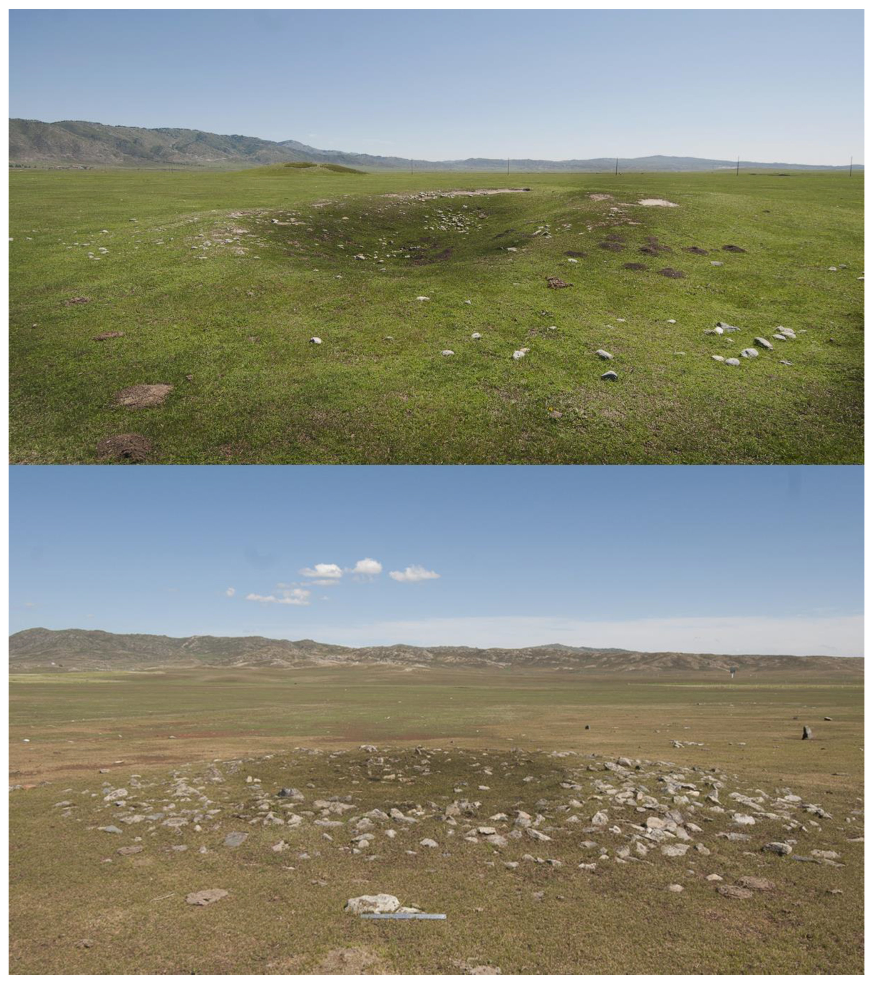
Xinjiang’s north is rich in Early Iron Age cultural heritage, and there is a wide range of architectural features which constitute early nomadic burials. Archaeologists distinguish geographically and temporally distinct subunits of Early Iron Age material culture. The most common type of early Iron Age burial in the northern Xinjiang steppes consists of a deep grave chamber in which the human remains and most of the items are found. The deep burial pit is covered with a mound—either consisting of stones, earth, or a mixture of both—which serves as a marker in the landscape (Figure 1). Upon looting of the central burial pit, a deep depression remains in the center of the monument which is clearly visible in high-resolution satellite imagery and aids the assessment of whether a tomb is destroyed or potentially unscathed. The absence of such a pit, however, does not necessarily mean that a burial mound is unlooted, since the complex taphonomics can lead to looting traces being substantially diminished.
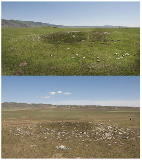
Figure 1.
Two general types of Early Iron Age burials can be distinguished in the region based on the construction materials: (upper) Burial mounds built from soil and (lower) burial mounds built from stones. Both monuments are completely looted, hence the deep central depression.
In Xinjiang, where extensive on-ground surveys are still the exception rather than the rule [7] it is very hard to estimate how much damage has been done to Early Iron Age cultural heritage. In this paper, we present the results of an assessment of a limited area of interest in northern Xinjiang, in which we combine an intensive on-ground survey and the evaluation of high-resolution optical satellite imagery with regard to detecting the share of looted or otherwise destroyed Early Iron Age burial mounds.
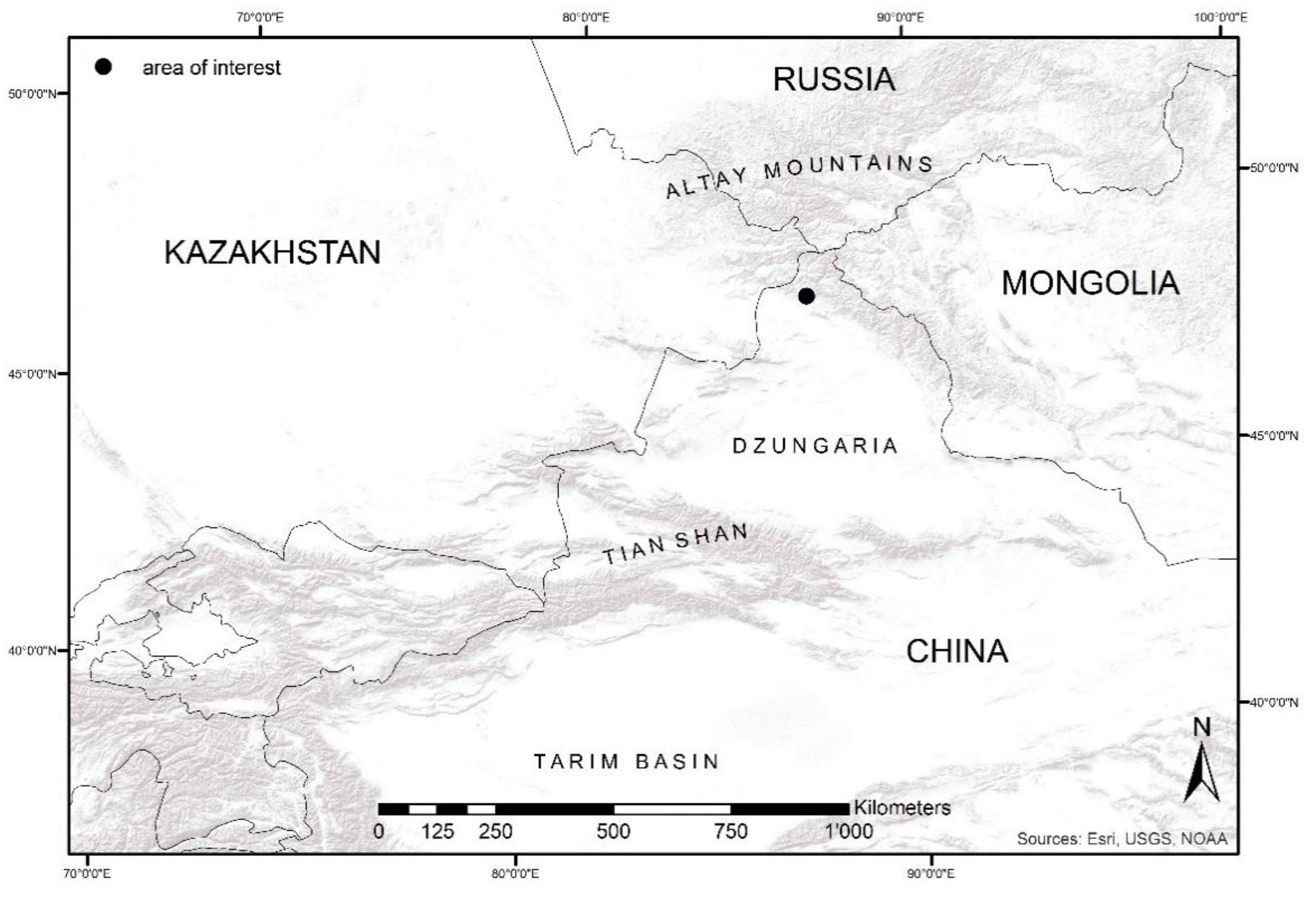
The area of interest was chosen in accordance with our previous field surveys, which have been conducted since 2015 in the foothills of the Chinese Altai Mountains in northern Xinjiang around the area of Heiliutan (Figure 2) [7]. Due to the increasingly difficult access in the autonomous region cf. [8], remote sensing assessment of cultural heritage gains additional weight cf. [9]. It is currently almost impossible to receive a permit for fieldwork conducted by Chinese-international collaborations.
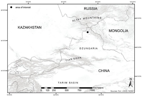
Figure 2.
The area of interest lies in the northern part of Xinjiang, China, in the foothills of the Altai Mountains.
2. Materials and Methods
To map out all the Early Iron Age burial mounds, we used Worldview-2 and Ikonos data provided by the DigitalGlobe Foundation. Worldview-2 data has a max resolution at nadir of 0.46 m panchromatic and 1.85 m multispectral [10]. Ikonos has a max resolution at nadir of 0.82 m panchromatic and 3.28 m multispectral [10]. We also repeated the survey with publicly available data from Google Maps. We relied on a visual interpretation of the data, mapping out burials by hand in ArcGIS after overlaying the remote sensing imagery with a regular grid of 100 × 100 m. Even though automatic detection of circular features is now possible thanks to sophisticated algorithms [11,12,13], we needed an approach that guaranteed a consistent detection without gaps, and thus the visual interpretation was conducted by archaeologists familiar with the characteristics of the Early Iron Age burials of northern Xinjiang. For each burial mound, we assigned one of three categories: 1. “Looted” meaning exhibiting a clear looting pit or being fully destroyed; 2. “impacted” exhibiting smaller destructions and/or altered shape; and 3. “well-preserved” burial mound appears to be largely intact. If a burial was not visible in the remotes sensing data, it received the remark “NV” (not visible). We were not able to cover the entire area with Worldview-2 data, therefore, when we found a burial outside the covered area, the Worldview-2 data received the remark “NA” (not applicable).
In the subsequent field survey, a full intensive survey of the landscape (approximately 110 km2) was conducted to map out burials that were missed during the visual interpretation of the remote sensing data. For each Early Iron Age burial, an assessment of its preservation condition was conducted, in particular noting whether or not the burial showed signs of looting or otherwise exhibited traits of destructions according to the same three categories applied during the remote sensing survey.
The results were then compared to understand the extent of looting of Early Iron Age burial mounds as well as our ability to assess the extent of looting accurately from space without ground truthing.
3. Results
During our field survey, we identified a total number of 188 burial mounds potentially belonging to the Early Iron Age. Not all of them were visible in the remote sensing data due to their size and preservation conditions (Table 1).

Table 1.
The results of the visual interpretation of different remote sensing data and the on-ground survey (NA = not available, NV = not visible, 1 = looted, 2 = impacted, 3 = well-preserved).
For Worldview-2 data, we identified 18 burial mounds in good condition, 31 graves were somewhat destroyed, and 28 burials showed clear signs of looting with a deep pit in the middle of the structure. Similarly, in Ikonos data, we found 17 burial mounds in good condition, 26 which were partially destroyed, and 22 which were clearly looted. In publicly available data from Google Earth, the total number of detected burial mounds was higher: The number of looted burial mounds rose to 68, the number of well-preserved mounds decreased to 15, and the amount of partially destroyed burials increased to 38 (Table 1).
Ikonos data performed rather poorly. Only 34.6% of the burial mounds mapped during the survey were identified. Google Earth performed better and we were able to identify 63.8% of the burial mounds in the area of interest. For Worldview-2 data, a similar percentage of burial mounds (59.7%) were mapped in the covered area.
In a second step, we correlated the assessment made based on the different data types with the data collected during the survey. If the assessment was the same, i.e., the same category (1, 2, or 3) had been assigned to the same burial mound in both the on-ground survey and the visual interpretation, the data point received a 1. If there was a deviation between the assessment on site and from the remote sensing data, the data point received a 0. The percentages of adequate assessments can be found in Table 2. Burial mounds that were not visible in the respective data were not counted as wrong assessments.

Table 2.
Percentage of accurate preservation assessment.
4. Discussion
Overall, the results indicate that a substantial portion of Early Iron Age burial mounds in the area of interest have been looted or damaged. From the on-ground survey, we know that at least 74.5% of burial mounds have been impacted or looted. This number is likely to be higher because of taphonomic processes, which eradicate traces of destruction and looting (like, e.g., natural erosion, which over time refills a looting pit).
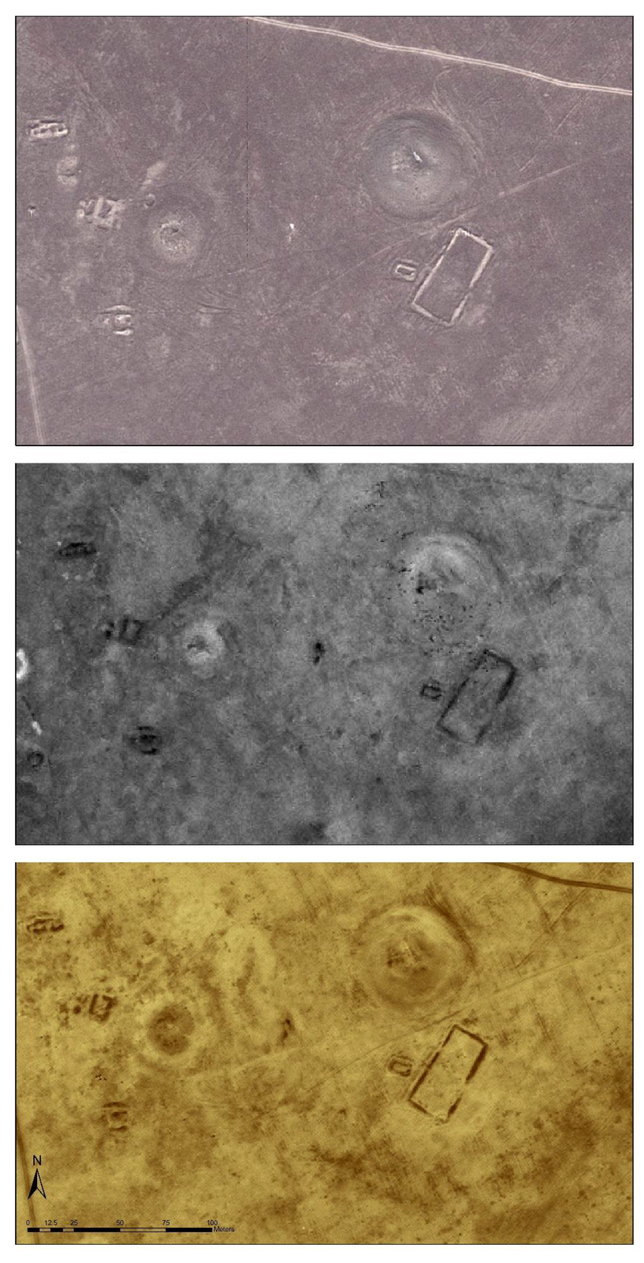
From Table 1, it is apparent that not all data types perform equally well when it comes to assessing looting-related destruction of Early Iron Age burial mounds. This seems to be largely connected to the resolution of the particular data. The size of the burial mounds plays a decisive role in their visibility and detectability. Many of the smaller burial mounds have only a diameter of 3–5 m and therefore are very hard to distinguish from surrounding rock outcrops and other natural features [14,15]. It then becomes pointless to try and assess their preservation condition because the number of pixels they are displayed by do not yield enough information for a solid visual interpretation. In some cases, dark bushes that grow in the middle of a burial mound can evoke the impression of a looting pit, when in fact the burial is in very good condition. For larger burial mounds, however, the visibility and the assessment of the preservation condition is usually not an issue. The assessment is fairly consistent over the different data types for large burial mounds (Figure 3).
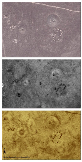
Figure 3.
(TD) Two large looted burial mounds (more than 20 m in diameter) in Google Earth, Ikonos, and Worldview 2 data.
An exact match between ground assessment and visual interpretation of the remote sensing data (like in Table 2), however, is a rather strict criterion. If we loosen this condition, aggregate clearly looted burial mounds and partially destroyed burial mounds, and therefore adopt a binary approach in which a burial mound is either destroyed/looted or well-preserved we see the following percentages (Table 3).

Table 3.
Destroyed and well-preserved Early Iron Age burial mounds based on assessment in different data types.
This seems to suggest that despite the differences in resolution of the different data types, a remote sensing survey can produce a good approximation of the preservation assessment through an on-ground intensive survey. Although it is currently not possible to create a fine classification of individual monuments and their preservation conditions, the general statement about the percentage of looted/partially destroyed Early Iron Age burial mounds is possible. This grasp on how bad the destruction of cultural heritage is in a specific area could already provide a valuable decision making tool for the local cultural heritage administration.
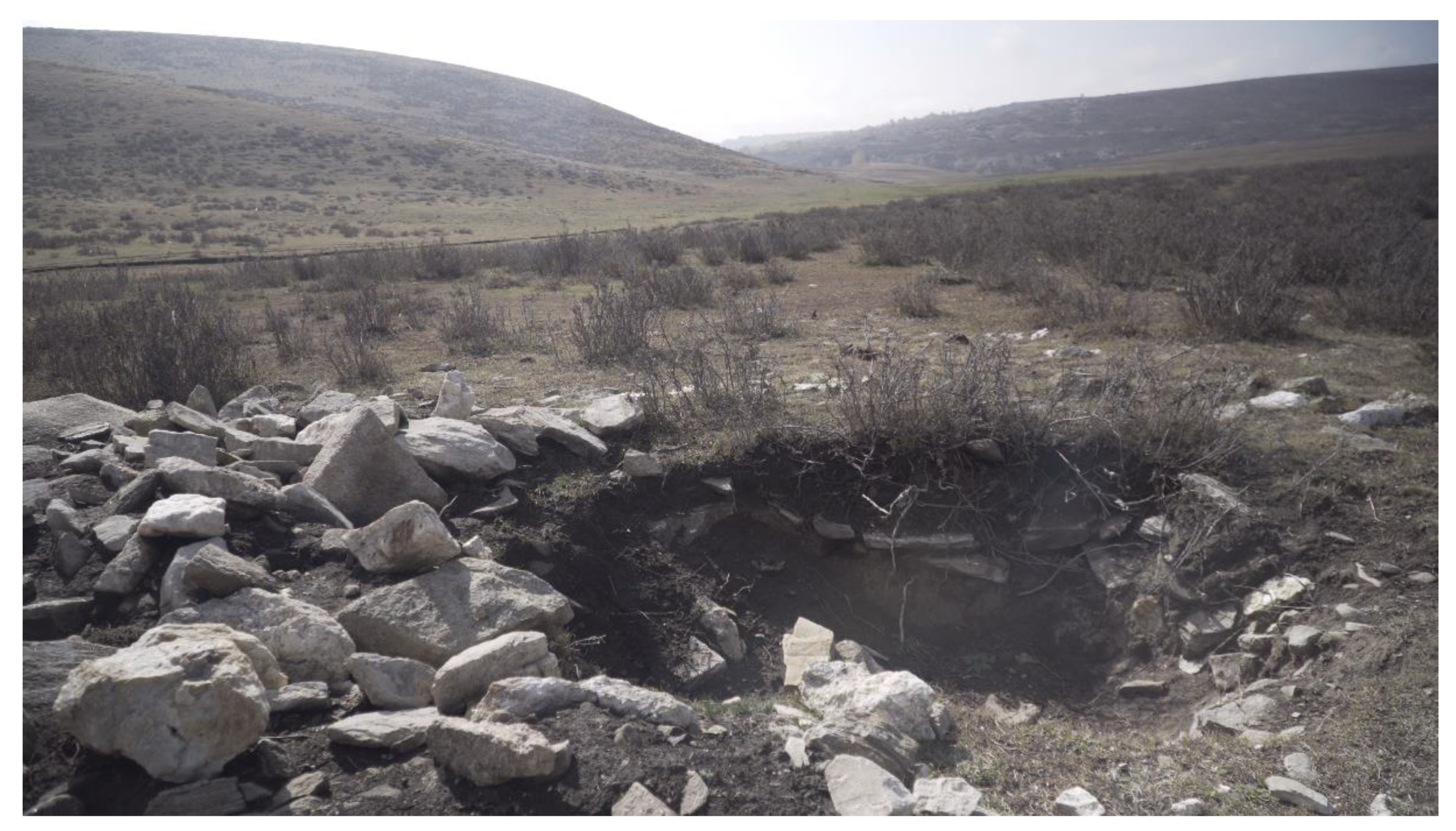
Speculatively, some of the difference between datasets could be explained through the temporal gaps between the acquisition of Ikonos, Worldview-2, and Google Earth data. The Ikonos imagery was generated in July 2003, the Worldview-2 data in September 2011, and the Google Earth imagery dates back to October 2012. The percentages in Table 3 continuously increase, which could hint towards an increase in looting activity. In the 1990s, the region was largely undeveloped, but plans were made to substantially increase tourism [16]. Only in 2007, the Kanasi Airport was opened [17] (after the acquisition of the Ikonos data) and with it came a massive influx of travelers and tourists [18]. One might hypothesize that the increase in destruction of cultural heritage is tied to the opportunity for local people to establish a new market and sell looted archaeological items to tourists. Of course, this is merely a guess and needs further research in the region to understand today’s looting activity and the supply chain of illegally excavated artefacts. In any case, we were able to determine, that looting and destruction of cultural heritage continues. We were able to locate a number of recently robbed tombs during our field survey (Figure 4).
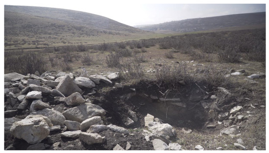
Figure 4.
A recently looted (2016) Early Iron Age burial in the area of interest (Photo: Courtesy of T. Wallace).
5. Conclusions
It is possible to assess the looting of Early Iron Age burial mounds in northern Xinjiang through a remote sensing survey. A subcategorization of different destructions or an extent of the destruction of a single burial mound is difficult to achieve at this point, since data resolution is limited and the size of many burial mounds is too small to allow for a visual interpretation of the traces of destruction. However, the percentages of destroyed monuments are relatively consistent in all three remote sensing data sets (Table 3) and we can therefore assume that an approximation of the true extent of looting is possible through a remote sensing survey. Sequencing the data sets according to their acquisition date shows a steady increase in the percentage of looted burials and might hint to continued looting in the area, possibly in conjunction with developing tourism. The discovery of recently looted tombs during the field survey support this hypothesis. Considering that a substantial portion of local cultural heritage of the Early Iron Age has already been destroyed, it is advisable to put measures of protection in place or else provide the financial means for rescue excavations.
Funding
This research was made possible through a data grant of the DigitalGlobe Foundation.
Acknowledgments
The author would like to acknowledge the support he received from the Chinese Academy of Sciences and the University of Wuhan during the field survey, in particular by B. Fu and T. Balz.
Conflicts of Interest
The author declares no conflict of interest.
References
- Van Geel, B.; Bokovenko, N.A.; Burova, N.D.; Chugunov, K.V.; Dergachev, V.A.; Dirksen, V.G.; Kulkova, M.; Nagler, A.; Parzinger, H.; Van der Plicht, J. Climate change and the expansion of the Scythian culture after 850 BC: a hypothesis. J. Archaeol. Sci. 2004, 31, 1735–1742. [Google Scholar] [CrossRef]
- Jettmar, K. Art of the Steppes: The Eurasian Animal Style (No. 21); Methuen: New York, NY, USA, 1967. [Google Scholar]
- Rostovtzeff, M. The Animal Style in South Russia and China; L’erma di Bretschneider: Rome, Italy, 2000; Volume 4. [Google Scholar]
- Parzinger, H. Burial mounds of Scythian elites in the Eurasian steppe: New discoveries. J. Br. Acad. 2017, 5, 331–355. [Google Scholar] [CrossRef]
- Korolkova, E. The Siberian Collection of Peter the Great. In The BP Exhibition: Scythians: Warriors of Ancient Siberia; Simpson, S.J., Pankova, S., Eds.; Thames & Hudson: London, UK, 2017. [Google Scholar]
- Lawler, A. Landing the Looters. Science 2009, 325, 937. [Google Scholar] [CrossRef] [PubMed]
- Caspari, G.; Plets, G.; Balz, T.; Fu, B. Landscape archaeology in the Chinese Altai Mountains–Survey of the Heiliutan Basin. Archaeol. Res. Asia 2017, 10, 48–53. [Google Scholar] [CrossRef]
- Clarke, M. China’s “War on Terror” in Xinjiang: Human Security and the Causes of Violent Uighur Separatism. Terror. Political Violence 2008, 20, 271–301. [Google Scholar] [CrossRef]
- Balz, T.; Caspari, G.; Fu, B.; Liao, M. Discernibility of Burial Mounds in High-Resolution X-Band SAR Images for Archaeological Prospections in the Altai Mountains. Remote Sens. 2016, 8, 817. [Google Scholar] [CrossRef]
- Satellite Imaging Corporation (2017) Satellite Sensors. Available online: https://www.satimagingcorp.com/satellite-sensors/ (accessed on 12 October 2018).
- Trier, Ø.D.; Larsen, S.Ø.; Solberg, R. Automatic detection of circular structures in high-resolution satellite images of agricultural land. Archaeol. Prospect. 2009, 16, 1–15. [Google Scholar] [CrossRef]
- Caspari, G.; Balz, T.; Gang, L.; Wang, X.; Liao, M. Application of Hough Forests for the detection of grave mounds in high-resolution satellite imagery. In Proceedings of the 2014 IEEE International Geoscience and Remote Sensing Symposium (IGARSS), Quebec City, QC, Canada, 13–18 July 2014; pp. 906–909. [Google Scholar]
- Traviglia, A.; Cowley, D.C.; Lambers, K. Finding common ground: human and computer vision in archaeological prospection. AARGnews 2016, 53, 11–24. [Google Scholar]
- Gheyle, W.; Trommelmans, R.; Bourgeois, J.; Goossens, R.; Bourgeois, I.; De Wulf, A.; Willems, T. Evaluating CORONA: a case study in the Altai Republic (South Siberia). Antiquity 2004, 78, 391–403. [Google Scholar] [CrossRef]
- Gheyle, W. Highlands and Steppes: An Analysis of the Archaeological Landscape of the Altay Mountains from the Eneolithic to the Ethnographic Period. Doctoral Dissertation, Ghent University, Ghent, Belgium, 2009. [Google Scholar]
- Baodi, M.; Tianqi, N.; Xiangfang, X. Tourist resources and tourism development in North Xinjiang. GeoJournal 1990, 21, 161–165. [Google Scholar] [CrossRef]
- Qin, J.; Zhang, P.; Deng, G.; Chen, L. A Study on Eco-Tourism and Sustainable Development of Economic Underdevelopment Areas—An Example from Kanas Nature Reserve, Xingjiang Province, Northwest China. Smart Grid Renew. Energy 2014, 5, 170. [Google Scholar] [CrossRef]
- Zhang, P.; Yao, J. Research on Change of Lakes-rivers Ecosystem Services Energy Value at Big Kanas Tourism Area. Water Resour. Power 2015, 8, 10. [Google Scholar]
© 2018 by the author. Licensee MDPI, Basel, Switzerland. This article is an open access article distributed under the terms and conditions of the Creative Commons Attribution (CC BY) license (http://creativecommons.org/licenses/by/4.0/).

