Article

Virtual Sea-Drifting Experiments between the Island of Cyprus and the Surrounding Mainland in the Early Prehistoric Eastern Mediterranean

by
Phaedon Kyriakidis
1,*,
Theodora Moutsiou
2,
Andreas Nikolaidis
1,
Christian Reepmeyer
3,4,
Georgios Leventis
1,
Stella Demesticha
2,
Evangelos Akylas
1,
Vasiliki Kassianidou
2,
Constantine Michailides
5,
Zomenia Zomeni
6,
Daniella E. Bar-Yosef Mayer
7,
Yizhaq Makovsky
8 and
Carole McCartney
2,†
1
Department of Civil Engineering and Geomatics, Cyprus University of Technology, 2-8 Saripolou Str., Achilleos I Bldg., Limassol 3036, Cyprus
2
Archaeological Research Unit, University of Cyprus, P.O. Box 20537, Nicosia 1678, Cyprus
3
Kommission für Archäologie Außereuropäischer Kulturen, Deutsches Archäologisches Institut, 53173 Bonn, Germany
4
ARC Centre of Excellence for Australian Biodiversity and Heritage, College of Arts, Society, and Education, James Cook University, Cairns, QLD 4870, Australia
5
Department of Civil Engineering, International Hellenic University, 62124 Serres, Greece
6
Cyprus Geological Survey Department, P.O. Box 2453, Nicosia 1301, Cyprus
7
The Steinhartdt Museum of Natural History, Tel Aviv University, 12 Klausner Street, Tel Aviv 6997801, Israel
8
Dr. Moses Strauss Department of Marine Geosciences, University of Haifa, Aba Khoushy Ave., Mount Carmel 199, Haifa 3498838, Israel
*
Author to whom correspondence should be addressed.
This author passed away.
Heritage 2022, 5(4), 3081-3099; https://doi.org/10.3390/heritage5040160
Submission received: 22 May 2022 / Revised: 13 September 2022 / Accepted: 23 September 2022 / Published: 12 October 2022

Abstract

:
Seaborne movement underpins frontier research in prehistoric archaeology, including water-crossings in the context of human dispersals, and island colonisation. Yet, it also controls the degree of interaction between locations, which in turn is essential for investigating the properties of maritime networks. The onset of the Holocene (circa 12,000 years ago) is a critical period for understanding the origins of early visitors/inhabitants to the island of Cyprus in the Eastern Mediterranean in connection with the spread of Neolithic cultures in the region. The research undertaken in this work exemplifies the synergies between archaeology, physical sciences and geomatics, towards providing novel insights on the feasibility of drift-induced seaborne movement and the corresponding trip duration between Cyprus and coastal regions on the surrounding mainland. The overarching objective is to support archaeological inquiry regarding the possible origins of these visitors/inhabitants—Anatolia and/or the Levant being two suggested origins.

1. Introduction

The elucidation of spatiotemporal patterns regarding prehistoric maritime mobility has attracted global archaeological attention over the past 20 years within the context of island and maritime archaeology (especially in the Eastern Mediterranean), as they provide insights in understanding colonization pathways [1,2], maritime technological capacity [3,4] and social behavior of early colonists [5]. To that end, computer simulation models for seaborne movement were developed over the years, closely related to agent-based models [6], although not always explicitly stated as such. In such models, multiple virtual vessels embark from coastal locations and interact (in a stochastic or deterministic way) with winds, currents and (possibly) waves according to their postulated structural characteristics as well as their navigation skills and trip motivation. Computer simulations models of seaborne movement have been used to illustrate maritime inter-connections, as well as test archaeological hypotheses related to colonisation, migration, and cultural contact [7,8,9,10,11,12,13,14].
Cyprus, one of the largest islands in the Mediterranean, is situated approximately 100 km from the nearest Levantine coast and 60 km from the southern coast of Turkey (Figure 1). Cyprus plays a key role in early Mediterranean prehistory, as it has been insular since the Miocene (earlier than at least 5 million years ago); this entails that any archaeological evidence of early prehistoric human presence/activity on the island implies seaborne mobility. In recent years, there has been a rewriting of Cyprus’s earliest prehistory, with new dates firmly setting the initial colonization of Cyprus into the Terminal Pleistocene (circa 12,000 years before present) before the appearance of Neolithic innovations in the Levant. These new dates are seen as a possible explanation for the ephemeral evidence of human presence on the island dating back to the end of the Pleistocene and the beginning of the Holocene [15,16,17,18]. As such, the onset of the Holocene is a critical period for understanding the origins of early visitors/inhabitants to Cyprus in connection with the spread of Neolithic cultures in the region. Considerable debate, however, still exists as to: (i) where these visitors/inhabitants originated from—Anatolia and/or the Levant being two suggested origins based on similarities of the material record, e.g., architecture, lithic technology, fauna and flora; and (ii) possible routes they might have followed to reach the island. A very recent study based on ancient DNA data obtained from three individuals found on Cyprus indicates Anatolia as the genetic source of early Pre-Pottery Neolithic inhabitants of Cyprus [19].
Capitalizing on relatively recent archaeological findings, physical modelling, palaeogeographic reconstruction, and computer simulation, this research provides novel insights into physical controls on potential seaborne mobility (a proxy for maritime connectivity) between Cyprus and other Eastern Mediterranean coastal regions at the onset of the Holocene. Vessels postulated to be in use for that period (possibly even earlier) in the Eastern Mediterranean include logs, dugout canoes and wooden rafts [20,21,22,23,24]. Along these lines, the types of vessels considered in this work include a log (approximated by a surfboard) and a small wooden raft [20,21]; similar approximations have been adopted elsewhere for simulating prehistoric seaborne movement (e.g., [13,25]). Although Cyprus is visible from several parts of the coast of southwest Asia [21,26,27], a fact that might have motivated directed seaborne movement towards visible targets such as the ~2000 m high Troodos Mountain in the island’s center, the type of seaborne movement tested in this work pertains to sea drifting, i.e., movement over the sea solely due to currents and winds; that is, movement without any regulated human effort such as paddling directed towards a destination. Sea drifting could occur in the context of involuntary or accidental movement once a vessel is stranded at sea. Alternatively, sea drifting might purposefully be sought after for “not-too-distant” visible or previously known destinations (such as Cyprus); this drifting mode would evidently entail a good understanding of local weather patterns as well as surface sea currents. Against this backdrop, drifting simulation has been investigated since the 70’s in the context of accidental versus planned colonization of the Pacific [7] and more recently in the context of minimum founding island populations [14,28,29,30]. Similarly, in this work, the trajectories of drifting vessels originating from several regions scattered throughout the coast of southwest Asia and Cyprus are simulated and subsequently analyzed in terms of their success in reaching the opposite shore. The proportion of successful trajectories, as well as the duration of the corresponding trips, provide novel information on physical aspects of potential maritime connectivity between Cyprus and the surrounding mainland, in support of archaeological inquiry on the possible origins regarding Cyprus’s early visitors/inhabitants.
Archaeological context: Sketching human trails from the late Epipaleolithic to the Pre-Pottery Neolithic era.
It was long believed that Mediterranean islands could only have been settled by farmers because of the limited resources available on islands. This hypothesis has been challenged with the excavations of Akrotiri-Aetokremnos rock shelter, which firmly established first human arrival on Cyprus in the Terminal Pleistocene (e.g., [31]), with later discoveries pertaining to the existence of forager occupation [32]. Since then, the excavations at Aetokremnos have dominated debates of late Pleistocene/early Holocene sites in Cyprus [33,34]. More recent finds of a possible Epipalaeolithic (circa 12,000 calibrated years before present, cal BP) habitation site in the Troodos foothills, Vretcha-Roudias [35,36,37,38]. Ephemeral coastal surface artefact scatters such as Akamas-Aspros and Nissi Beach, both of which have lithic assemblage with Late Epipalaeolithic character, are also supporting evidence for a Terminal Pleistocene occupation of Cyprus [39,40]. Aspros is significant because of its rich lithic assemblage and because it contains the first trace of material recovered offshore during an underwater survey. In this case, the anticipated loss of early sites because of the Last Glacial Maximum (LGM) and subsequent sea level rise are demonstrated. A second cluster of sites reported by surveys in central Cyprus provides 12 more surface-collected lithic assemblages with analogies to the excavated Akrotiri phase sites [41,42,43]. Even though they are currently not dated, these sites demonstrate possible early exploration from the shore to the island’s interior via the Tremithous and Yialias river basins [42,44].
The two important early Pre-Pottery Neolithic A (PPNA) sites of Ayia Varvara Asprokremnos and Ayios Tychonas Klimonas also re-dated the earliest Aceramic Neolithic occupation which is now more or less parallel to the development of agriculture in the Levant, starting from around 11,000 cal BP [45,46,47,48,49]. Structures found at Klimonas beginning in the early Cypriot-PPNA point to similarities in round-building design in the Northern Levant [48,49]. Recently, similar oval, semi-subterranean features, although with wattle-daub construction, have also been found in the Pinarbasi rock shelter from the Central Anatolian plateau in an Epipalaeolithic context which indicates that the extent of the western distribution of this feature in Turkey is not well understood [50]. However, the settlement organisation of having a larger, round central building and smaller living quarters surrounding this building is so far unknown in Central Turkey, but has parallels with sites such as Jerf El-Ahmar and Wadi Faynan in the Levant [51].
Early sites in Cyprus represent a unique artefact ensemble, including picrolite ornaments that most likely are the Cypriot equivalent of the green stone beads used during the Late Natufian and early Neolithic [52]. Though the diversity of ground stone types belonging to the Cypriot sites is not great, the grooved stone interpreted as a possible net weight and the perforated disc from Aetokremnos not only have parallels with Cape Andreas Kastros on the North coast of Cyprus, but are widely found in the Levant [33]. Shaft-straighteners have been found at Klimonas, Ais Giorkis and Ayia Varvara and these match in their decoration by hatchings and criss-cross-pattern artefact types in the Northern Levant, for example, Tell Abr’ and Tell Qaramel [53]. The flaked lithic assemblage of Akrotiri Aetokremnos is in its majority flake-based and dominated by thumbnail scrapers [33] which have similarities to Northern Levantine Natufian sites. Direct connection with the South Turkey coast, as suggested by [54], is problematic as it is based on the narrow set of types, particularly narrowly backed crescents and steeply backed bladelets which are found in large numbers at Öküzini cave in the Epi-Gravettiean, but are also a type fossil of the Natufian in the Levant. In the transition to the later sites, there is a change from flake-dominated assemblages to flake/blade assemblages with burins made from flakes, projectile points and blades with lateral retouches and notches [51,55]. In addition, we see sickles in significant numbers appearing. The affinity with the Northern Levant, which has been noted in the earlier periods, continues in the Cypriot PPNA with the occurrence of Mureybet or Cheikh Hassan points prominent both in Klimonas as well as Ayia Varvara [51]. Exotic raw materials, such as obsidian, derive from Central and Eastern Anatolian sources in aceramic Neolithic Cyprus. A sourcing study showed that most of the obsidian originated in the Central Anatolian Göllü Dağ source, with a small number sourced to Nenezi Dağ. One piece was sourced to the East Anatolian Bingöl B [56]. It is unclear at this stage whether these raw materials were transported via a direct contact to the South Turkey coast as no obsidian cores have been found in Cyprus and the artefacts appear to be imported in their final form of blades. This indicates a possible indirect arrival of Anatolian raw materials to Cyprus through Levantine sites functioning as steppingstones in this distribution system [56]; see [57,58] for more information on early seafaring around Cyprus.

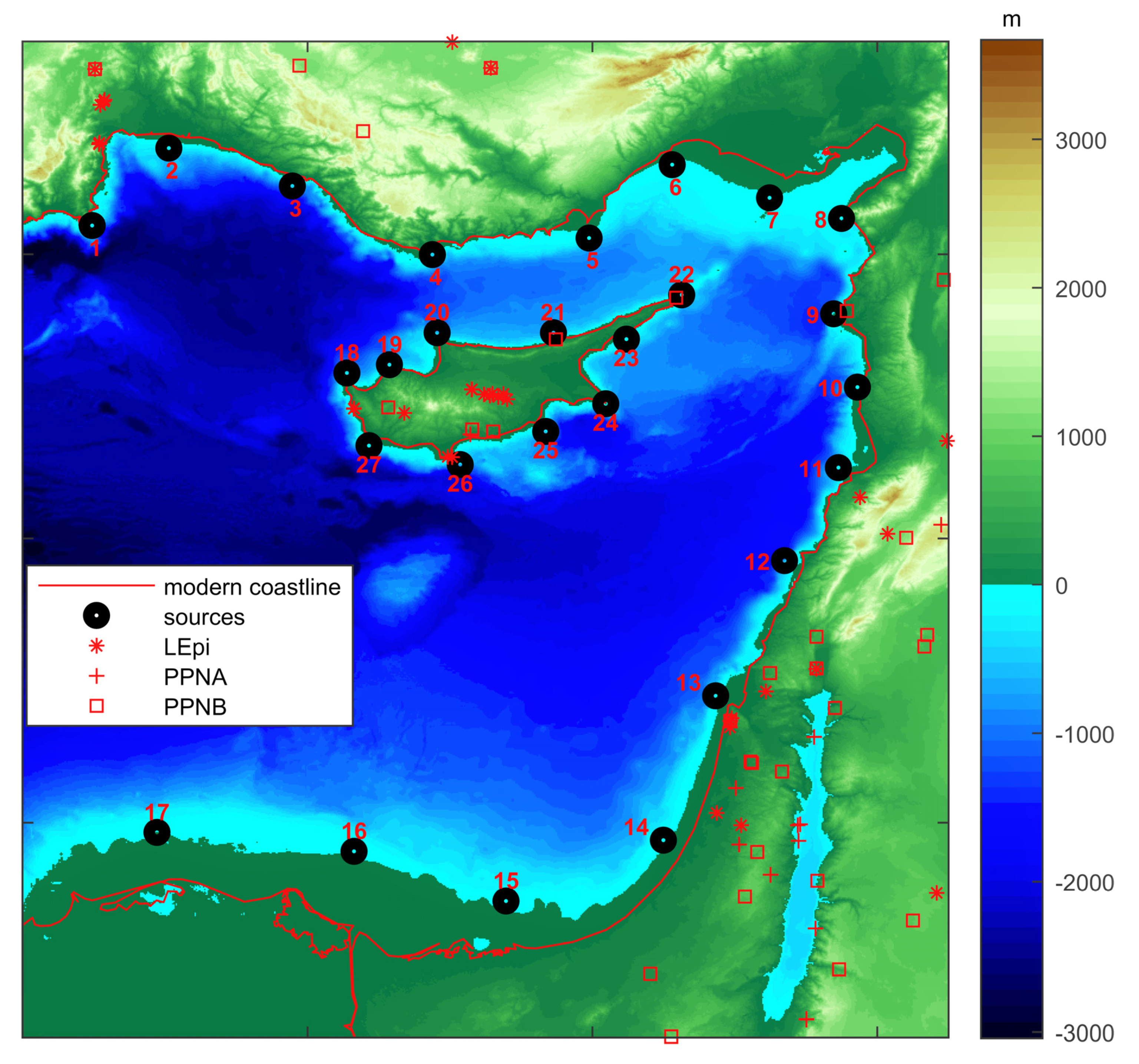
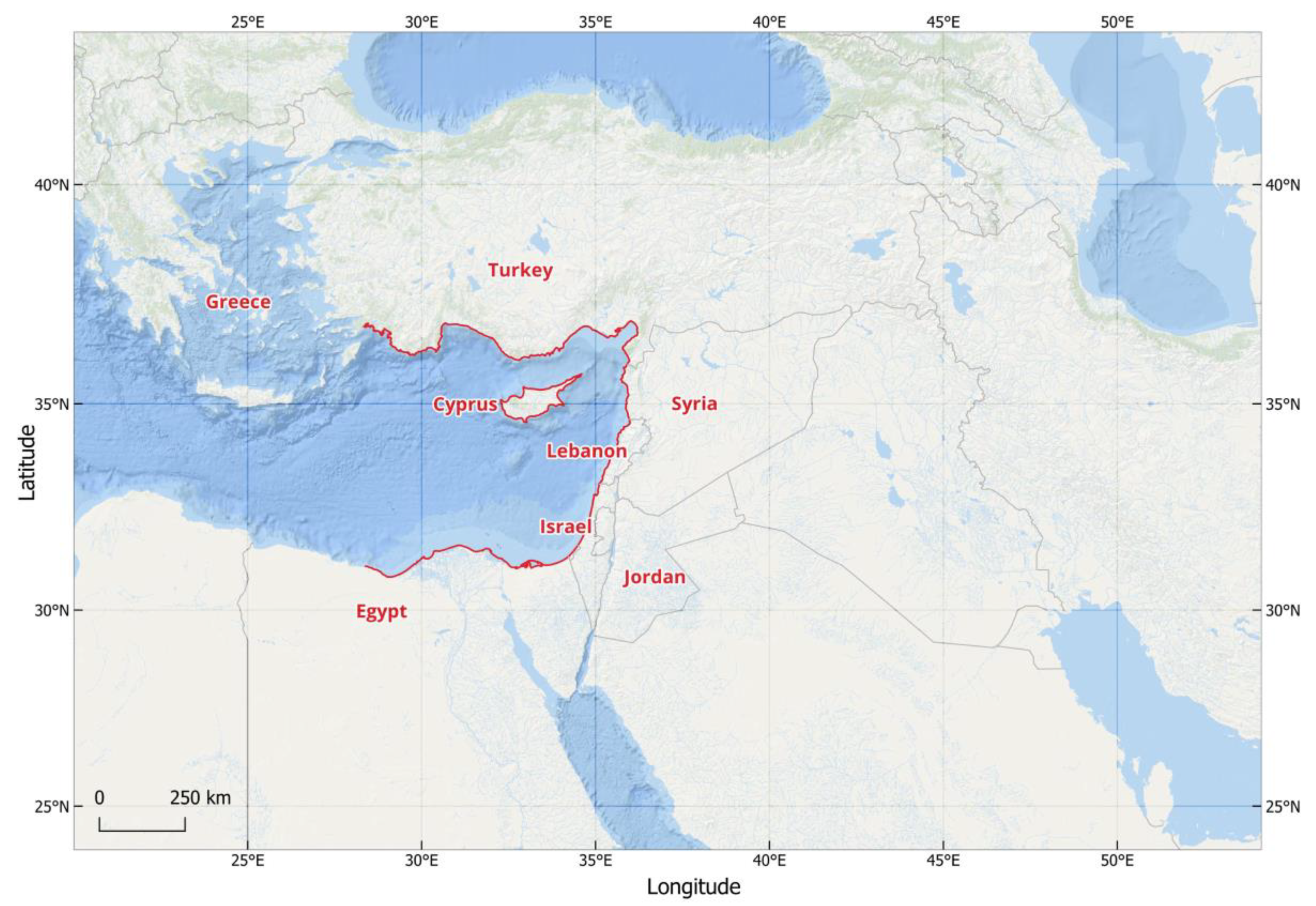
2. Materials and Methods
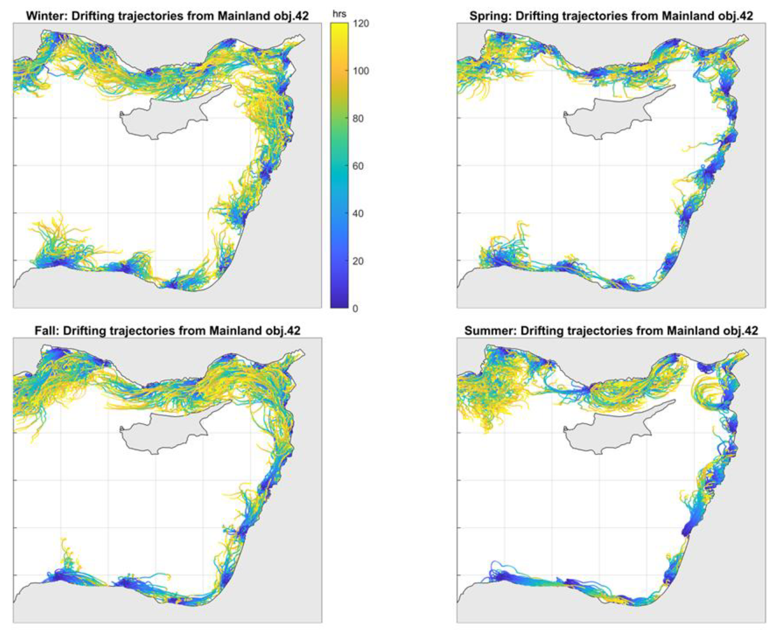
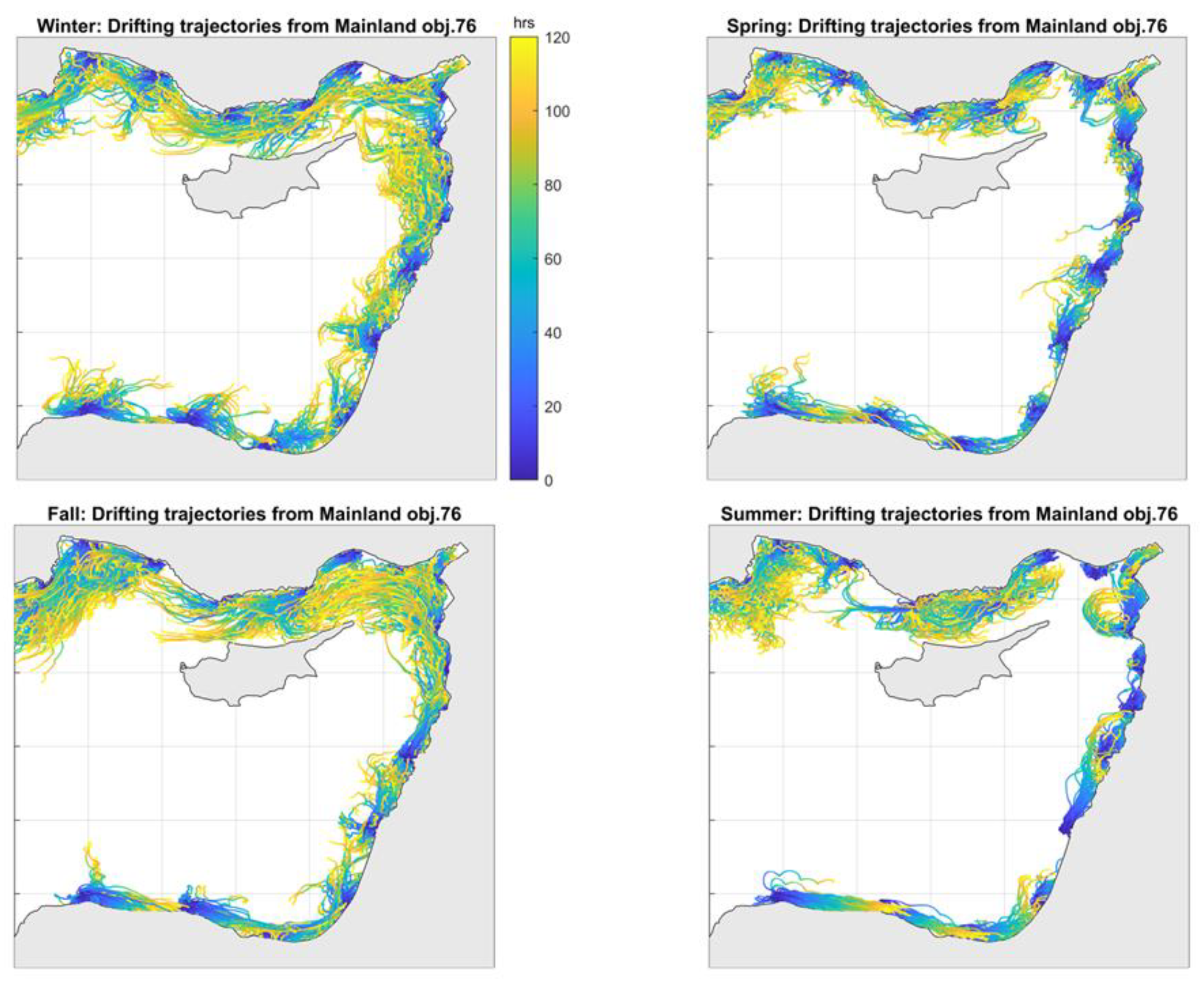
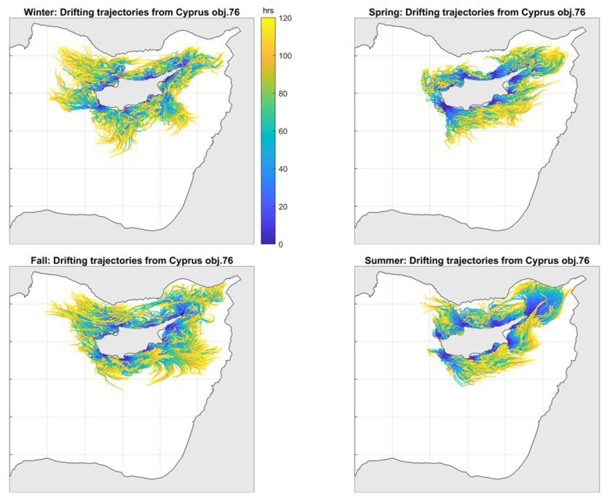
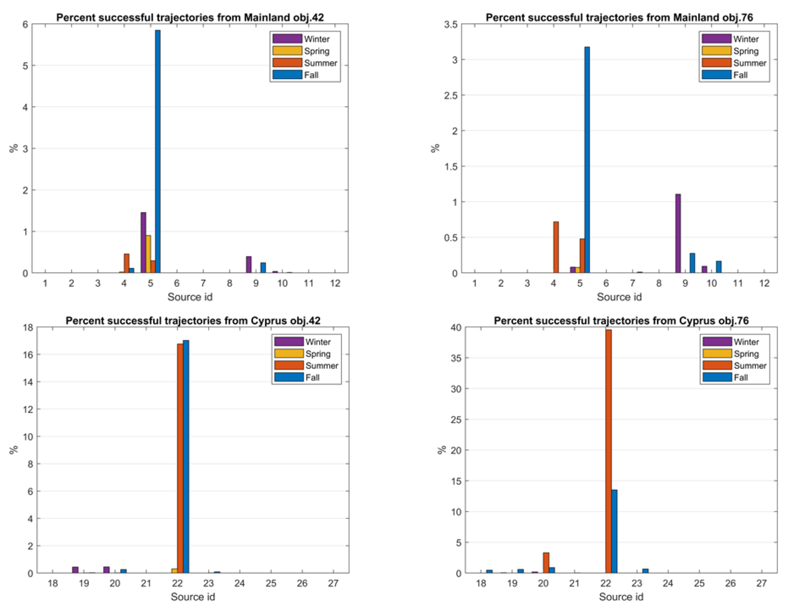
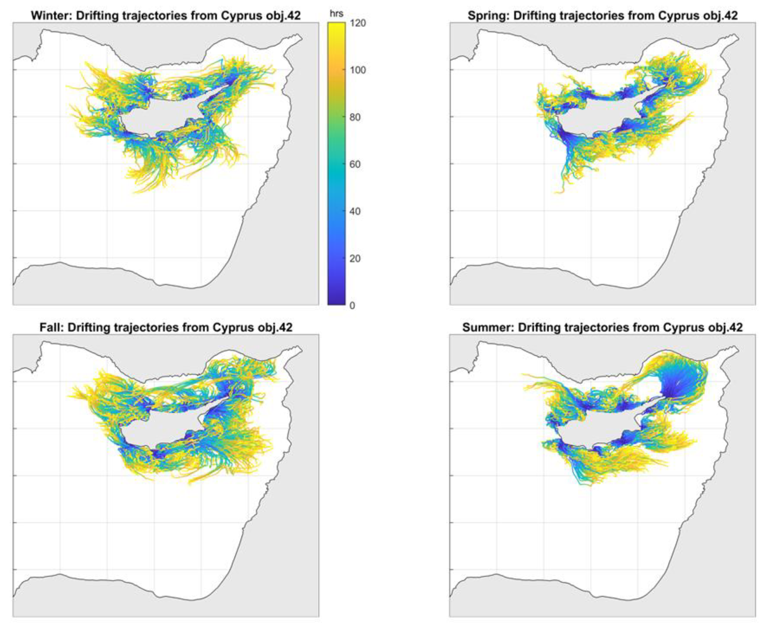
The drift-induced seaborne movement to/from Cyprus of rudimentary vessels believed to be in use in the Eastern Mediterranean during the early Holocene (see below) is simulated hereafter, as a means towards enhancing our understanding regarding the possible origins of the first visitors to Cyprus. Vessel trajectories are simulated based on data and assumptions about prevailing paleo-geographical conditions (re-constructed bathymetry/coastline) and air/sea circulation conditions parameterised by near-surface wind speed and direction and sea current speed and direction. The overarching assumption posits that general conditions of atmospheric and ocean/sea circulation during the early Holocene in the region are not too different than present-day conditions, an assumption that has been adopted before in similar contexts [20,26].
Present-day bathymetry data used in this work were synthesised from the European Marine Observation Network (EMODnet) bathymetry1, the Shuttle Radar Topography Mission (SRTM) land topography2, and a recent R/V Marion survey of the Eratosthenes Sea mount, integrated and sub-sampled at approximately a 1.1 × 1.1 km2 spatial resolution grid (Figure 2); note that EMODnet’s bathymetry spatial resolution is approximately 115 × 115 m2, whereas SRTM’s land topography spatial resolution is approximately 30 × 30 m2. The paleobathymetry at the onset of the Holocene was reconstructed using present-day bathymetry and published global mean sea level curves [59] indicate a mean sea level of approximately −60 m below the present-day sea level for that period. The paleobathymetry was thus estimated by shifting the present-day bathymetry by 60 m upwards; the present-day −60 m isobath becomes the 0 m isobath for the early Holocene and corresponds to the paleocoastline for that period. It should be noted that, although more detailed local bathymetry and corresponding coastline reconstructions are recommended for palaeogeographic coastal environments to account for tectonic activity [60], such information was not available for this work; this implies the presence of uncertainty regarding the reconstructed paleobathymetry and paleocoastline.
Present-day COSMO REA-6 reanalysis data [61] on wind speed and direction at 10 m height above the sea surface, with an hourly temporal resolution and a 6 × 6 km2 spatial resolution, were downloaded from the Hans-Ertel-Centre for Weather Research Climate Monitoring and Diagnostics of the University of Bonn3 and re-sampled (interpolated) at a 1.85 × 1.85 km2 spatial resolution for the purposes of subsequently simulating trajectories of drifting vessels at sea. In addition, present-day reanalysis data on the speed and direction of surface sea currents, not containing the effects of tidal currents and representing average circulation over the top 2 m of the water column [62], with a daily temporal resolution and a 4.5 × 4.5 km2 spatial resolution, were downloaded from the Copernicus Marine Environment Service (CMES)4. These sea surface currents data along with the COSMO REA-6 wind data, salinity data, and the previously reconstructed palaeobathymetry, were employed as forcing to physically downscale (increase the spatial and temporal resolution of) the daily currents data to an hourly temporal resolution and a spatial resolution of 1.85 × 1.85 km2 using the Regional Ocean Modeling System (ROMS [38]). Physical or dynamic downscaling increases the spatial and temporal resolution of oceanic or atmospheric data, also taking into account physical equations governing the problem at hand, as opposed to the spatial interpolation step adopted for the wind data above which resamples data to higher resolutions without incorporating physical knowledge; the former method is known to produce more physically meaningful results as indicated by [63] in an atmospheric sciences context. Physical downscaling was performed in this work using the Adaptive Grid Refinement In Fortran (AGRIF) version of ROMS [64,65,66,67], a free surface, hydrostatic primitive equations ocean model with terrain-following vertical coordinates [68] providing the ability to resolve process variability at very fine scales (especially in the coastal area), and their interactions with larger scales. The 10 m above mean sea level wind data and the sea surface current data, both transformed to an hourly temporal resolution and a 1.85 × 1.85 km2 spatial resolution via interpolation and physical downscaling, respectively, are subsequently used to simulate trajectories of drifting objects corresponding to vessels at sea (drift-induced movement).
Following [69], the drift-induced motion of an object at sea stems from movement due to ocean currents, and movement relative to ambient water. Current-induced drift is object-independent and is mainly informed by the sea surface currents data described above. Movement relative to ambient water, also termed leeway [70,71], stems from wind and waves acting on the object; the latter (wave-induced motion) is negligible when drifting objects are relatively small, less than some 10s of meters. Leeway is decomposed into downwind and crosswind components [71,72], which are linked via linear regression models to a wind speed at 10 m height above mean sea level based on experiments conducted at sea by the US Coast Guard Service (e.g., [73]) in the context of Search-and-Rescue operations. The estimated regression coefficients are uncertain, due to errors associated with the wind and current measurements, and most importantly due to the inherent variation in the leeway properties of objects. Uncertainty in the estimated regression coefficients is encapsulated in their standard errors and is hereby explored by Monte Carlo simulation, whereby different regression coefficients, hence different regression models, are selected at random for each simulated object trajectory. The result is a “cloud” of candidate positions for drifting objects, i.e., an ensemble (set) of object trajectories for a given departure location and time, accounting for the (additive) effects of surface sea currents and winds [71,72].
Drifting objects considered in this work correspond to: (a) a surfboard (3.7 m long, 1 m wide, 200 Lts volume) at sea with a person on it, emulating an individual lying on a log, and (b) a small wooden raft (2.1 m long, 1.1 m wide, and 0.2 m thick) capable of carrying up to five (5) people. Previous applications of the leeway model in conjunction with similar objects in an archaeological context can be found in [9,25,74]. The simulation of seaborne movement of these objects under the leeway model is implemented using the OpenDrift Lagrangian particle tracking model [75]; the surfboard with the person is referred to as object #42 in Open-Drift’s catalogue of available objects, whereas the small wooden raft is referred to as object #76. The regression coefficients linking down- and cross-wind leeway speed-to-wind speed at 10 m above mean sea level for these objects are taken from [73].
For examining probable seaborne connections between Cyprus and the surrounding mainland, a set of one hundred (100) objects (virtual vessels) were simultaneously released for each day of a calendar year within a 5 km radius from 27 coastal regions spread out along the Eastern Mediterranean shorelines and the island of Cyprus (see Figure 2). Object release regions 1 to 17 are located off the coast of southwest Asia, and regions 18 to 24 are located off Cyprus’s coast. Simulations are conducted for every calendar day during one (1) year (2014, in particular), starting every day at a random initial time and producing hourly results for a duration of 120 h (5 days); that is, each simulated trajectory consists of 120 points, one per hour (simulation time step). This 5-day maximum duration for the simulation experiments was selected taking into consideration published limits regarding human endurance at sea [76]. Dynamic representations (animations) of simulated trajectories of floating objects, along with the corresponding sea surface currents and wind data affecting seaborne movement at each simulation time step, can be found at the SaRoCy project website5. Moreover, to acquire a better understanding of the plausible drifting paths between Cyprus and the surrounding mainland, we hereafter present simulated trajectories for each source location (Figure 3, Figure 4, Figure 5 and Figure 6) that are color coded according to the duration of travel since object release. Simulated trajectories are presented per season, as this temporal partition is more sensible for understanding seasonal patterns of movement potential than a monthly partition.
A simulated trajectory is considered as successful (a landfall) if at any point of its path it reaches within 5 km off the opposite coast without encountering any significant wave height (average height of the 30% highest waves) greater than 2 m; once a landfall is made, a simulated trip is terminated. The wave data used consist of hourly data on significant wave height [77] of approximately 4 × 4 km2 spatial resolution, which were downloaded from the CMEMS6 and resampled to a 1.85 × 1.85 km2 spatial resolution to match the resolution of both sea surface currents and winds data sets. The 5 km distance from coast threshold is adopted assuming the ability to successfully paddle towards the shore within that distance; whereas, the 2 m significant wave height threshold corresponds approximately to the average significant wave height estimated during Mediterranean storms events [78]. Evidently, these threshold values are subjective and their impact on the results could be further investigated (not undertaken in this work) within a sensitivity analysis context. Additional effects hindering successful water crossings, such as hypothermia, fatigue, or dehydration, are not explicitly considered in this work; see [79] for a relevant recent publication.

3. Results

Figure 3, Figure 4, Figure 5 and Figure 6 present examples of simulated object trajectories over all seasons, regardless the success (i.e., routes that arrived to a destination) or not of each trajectory. Figure 3 and Figure 4 correspond to trajectories originating from the mainland, whereas Figure 5 and Figure 6 correspond to trajectories originating from Cyprus. Only a subset (3 out of 100) of simulated trajectories are displayed for each day for each source region; this implies that the patterns shown in these figures reflect only partially the general sea circulation and wind conditions of the region. Since the two objects do not extend too much above the sea surface, their movement is mostly controlled by the sea currents and to a lesser extent by the wind. As a result, the spatiotemporal distribution of simulated object trajectories mostly reflects the prevailing clockwise geostrophic ocean circulation.
In terms of simulated trajectories departing from the mainland (Figure 3 and Figure 4), trajectories from northern present-day Egypt move eastwards, parallel to the coast, towards the Levantine coast; whereas, trajectories from the Levantine coast move northwards, again parallel to the coast, towards present-day Syria and southern Turkey (see also Figure 1). In addition, trajectories from southern Turkey move westwards and tend to be more variable, occupying all the straits between southern Turkey and norther Cyprus (some appearing to reach Cyprus); this pattern of more occupied space is less pronounced during Spring. Overall, it appears that during Winter and Fall, drifting conditions are more favorable to help an object drift to Cyprus within 80 to 120 h.
In terms of simulated trajectories departing from Cyprus (Figure 5 and Figure 6), trajectories appear to be longer, hence move faster. Overall, it appears that conditions during Fall and Summer are more favorable for drifting northwards towards southern Turkey and the Iskenderun Bay (to the northeast of Cyprus); drifting towards the coast of present-day Syria (east of Cyprus) appears to be more favorable during Winter with a small raft (object #76); see Figure 6.
In what follows, the originally simulated drifting trajectories are analyzed in terms of their success in reaching the opposite coast. A trajectory is considered successful if it reaches within a distance of 5 km from the opposite shore, and no significant wave height greater than 2 m is encountered at any point along that trajectory. Figure 7, Figure 8, Figure 9 and Figure 10 display all successful trajectories during the different seasons for both objects.
In terms of successful drifting towards Cyprus (Figure 7 and Figure 8), drifting with a surfboard appears to be overall more successful than with a small raft, at least for this particular year considered. Drifting to Cyprus from the southern coast of Turkey appears most favorable than other source regions, with two locations in northern Levant (present-day Syria) also providing favorable departure regions during Winter and Fall. Note, however, that no archaeological sites have been discovered in southern Turkey for that late Epipaleolithic/early Neolithic period; hence, any physical connectivity should not be necessarily interpreted as archaeological connectivity.
In terms of successful drifting towards the mainland (Figure 9 and Figure 10), drifting appears to be more successful during Fall and Summer, and from cape Agios Andreas at the northeastern tip of Cyprus towards southern Turkey; no simulated trajectory ended up at the Levantine coast. It is interesting to note that drifting during Spring appears to be rather unfavorable, as no simulated trajectories of the raft object reach the opposite coast (Figure 10), and successful simulated trajectories of the surfboard object are rather few (Figure 9).
In what follows, analysis pertains to the duration of successful trajectories, i.e., to the time passed since departure while the object was floating at sea. Analysis is carried out in terms of distributions (relative frequency histograms) of travel times for the two objects across seasons (Figure 11, Figure 12, Figure 13 and Figure 14).
When departing from the mainland, simulated trip duration for both objects (Figure 11 and Figure 12) appears to be the shortest during Spring (shortest for the small raft), and the longest during Summer; during Winter and Fall, trip duration values range from 48 h (2 days) to 120 h (5 days) with more durations towards 5 days.
When departing from Cyprus, simulated trajectories during Fall season appear to be the shortest for both types of vessels (Figure 13 and Figure 14), with most trips extending between 72 h (3 days) and 96 h (4 days). Trip duration during Winter is the longest for both objects; trip duration is longer than 4 days for the small raft (Figure 14).
Analysis lastly pertains to the overall percentage of successful trajectories corresponding to different departure regions (Figure 15). It appears that, overall, drifting success rates from the mainland are very small: success rates are smaller than 6% (during Fall) for the surfboard and smaller than 3.5% (during Fall) for the small raft (see top row of Figure 15); these numbers correspond to trajectories from departure location #5 in southern Turkey (Figure 2), where no relevant archaeological evidence of human occupation is known to date. Success rates from locations #9 and #10 at the northern Levantine coast, where the archaeological record suggest human occupation during the period of interest, are significantly smaller than 0.5% (apart from a ~1% success rate for trajectories simulated for a small raft during Winter). This implies that, based on the 2014 data considered, drifting to Cyprus from the mainland should have been highly improbable.
When drifting from Cyprus, success rates are much higher, especially for the departure region of Cape Agios Andreas, ranging during Summer from 16% for the surfboard to 40% for the small raft; during Fall, these rates drop to 17% for the surfboard to 14% for the small raft (see bottom row of Figure 15). Note, however, that the corresponding times at sea typically exceed 72 h (3 days), a fact that should also be considered when assessing the feasibility of the trip at the end.

4. Discussion

This research seeks to support hypothesis testing and archaeological interpretation regarding the feasibility of drift-induced seaborne movement between the island of Cyprus and coastal regions on the surrounding mainland at the onset of the Holocene (~12,000 years ago), a period during which Cyprus is believed to have received its first visitors/inhabitants. A combination of physics-based models and computer simulation are employed towards modelling drift-induced seaborne movement, estimating a null model of non-directed potential maritime connectivity between Cyprus and its surrounding coastal areas. Such a model can certainly be used as a basis for developing more realistic models of seaborne mobility, corresponding, for example, to paddling-induced movement at sea towards selected destinations, and adds to the broader discussion of short haul seafaring patterns around Cyprus in antiquity [80].
The data collected for the Eastern Mediterranean region pertained to the physical, geomorphological, oceanic, and climatic environment, as well as human occupation. From these data sources, only the latter (human occupation data) pertain to the Epipaleolithic/early Holocene period, while published global mean sea level curves furnish the link between present-day bathymetry and the reconstructed bathymetry for the early Holocene. The Regional Ocean Modeling System (ROMS) was employed to physically downscale coarse spatial resolution daily data on sea surface currents to finer spatial resolution hourly data. Trajectories of sea drifting objects corresponding to a person on a surfboard, as well as small wooden raft capable of carrying up to five persons, were simulated using the leeway method with parameters taken from US Coast Guard experiments at sea in the context of search-and-rescue operations. Vessel departure was parameterized in terms of 27 departure regions scattered throughout the coast of southwest Asia and Cyprus as possible departure scenarios. Simulated object trajectories were analyzed in terms of their success in reaching the opposite shore (within a 5 km distance and without encountering significant wave height values greater than 2 m).
The results were overall similar for both vessels indicating that drifting to Cyprus should have been highly improbable. Drifting from Cyprus, however, appears to be more plausible, particularly during Fall and Summer, although consideration should also be given to the corresponding trip duration (longer than 3 days) in terms of final trip feasibility. Most successful drifts into Cyprus leave from present-day southern Turkey. However, no published archaeological sites dated to the early Holocene exist in that area; this might be attributed to such sites being currently submerged due to the rise in sea level since the early Holocene. It should also be noted, again, that our results should be regarded as lying on the optimistic side, i.e., the probability for successful drifting to Cyprus might be even lower, as the simulations conducted in this work do not explicitly account for additional effects, such as thermoregulation and dehydration, known to adversely influence seaborne travel, particularly during Winter and Summer, respectively, for this region of the world.
In terms of further research, the effects of several parameters, such as the −60 m difference between present-day and early Holocene bathymetries, as well as the 5 km distance to shore and the 2 m significant wave height used for the definition of successful trajectories, fixed in the current implementation of the methodology need to be further investigated in the context of a sensitivity analysis. More research is also needed to extend this work to additional vessels, such as a raft with a fixed sail mimicking a hide mounted onboard or larger watercrafts possibly used to transport livestock to Cyprus. This is particularly important as new findings of animal (wild boar, fallow deer) translocation in both Akrotiri as well as Klimonas point to a forager behaviour where early colonists appear to transport animals to increase biomass on the island [51]. The transportation of a large amount of cargo would require more significant investment in boating technology and would necessitate larger watercrafts for journeys to Cyprus. Further drifting experiments over more years are also required, preferably with data from paleoclimate and paleoceanographic simulations, to account for inter-annual variability; this is also of critical importance for reaching generalisable conclusions regarding the potential, or lack thereof, of drifting to Cyprus from the shores of southwest Asia.
In any case, the simulation of drift-induced seaborne movement undertaken in this work furnishes novel insights on island visitation in the Eastern Mediterranean for the early Holocene, along the lines of similar studies conducted elsewhere. In this sense, this study contributes significantly to the process of understanding physical aspects of potential maritime connectivity within the context of the spread of early Neolithic cultures in the Eastern Mediterranean.

Author Contributions

Conceptualization, P.K., T.M. and A.N.; methodology, P.K., A.N., S.D., E.A. and C.M. (Constantine Michailides); software, P.K., A.N. and G.L.; validation, P.K., A.N. and G.L.; formal analysis, P.K., T.M., A.N., C.R. and G.L.; investigation, P.K., T.M., A.N., C.R., G.L., S.D., D.E.B.-Y.M. and C.M. (Carole McCartney); resources, P.K.; data curation, A.N., Z.Z. and Y.M.; writing—original draft preparation, P.K., T.M., A.N., C.R., G.L., D.E.B.-Y.M. and C.M. (Carole McCartney); writing—review and editing, P.K., T.M., A.N., C.R., S.D. and V.K.; visualization, P.K., A.N. and G.L.; supervision, P.K., S.D. and V.K.; project administration, P.K. and V.K.; funding acquisition, P.K., T.M., A.N., S.D., E.A., V.K., C.M. (Constantine Michailides), Z.Z., D.E.B.-Y.M. and C.M. (Carole McCartney). All authors have read and agreed to the published version of the manuscript.

Funding

This work was conducted in the context of project SaRoCy: Delineating probable sea routes between Cyprus and its surrounding coastal areas at the start of the Holocene: A simulation approach, funded by the European Regional Development Fund and the Republic of Cyprus through the Research and Innovation Foundation of Cyprus under contract EXCELLENCE/0918/0143.

Data Availability Statement

The data presented in this study are openly available and can be found here: https://ktisis.cut.ac.cy/handle/10488/26944.

Conflicts of Interest

The authors declare no conflict of interest. The funders had no role in the design of the study; in the collection, analyses, or interpretation of data; in the writing of the manuscript, or in the decision to publish the results.

Notes

1. 
https://www.emodnet-bathymetry.eu/ (accessed on 9 September 2022).
2. 
https://www2.jpl.nasa.gov/srtm/ (accessed on 9 September 2022).
3. 
https://reanalysis.meteo.uni-bonn.de/?COSMO-REA6 (accessed on 9 September 2022).
4. 
5. 
6. 

References

  1. Field, J.S.; Lahr, M.M. Assessment of the Southern Dispersal: GIS-Based Analyses of Potential Routes at Oxygen Isotopic Stage 4. J. World Prehistory 2005, 19, 1–45. [Google Scholar] [CrossRef]
  2. Oppenheimer, S. Out-of-Africa, the peopling of continents and islands: Tracing uniparental gene trees across the map. Philos. Trans. R. Soc. B Biol. Sci. 2012, 367, 770–784. [Google Scholar] [CrossRef] [PubMed] [Green Version]
  3. Broodbank, C. The origins and early development of Mediterranean maritime activity. J. Mediterr. Archaeol. 2006, 19, 199–230. [Google Scholar] [CrossRef]
  4. Vigne, J.-D.; Briois, F.; Zazzo, A.; Willcox, G.; Cucchi, T.; Thiébault, S.; Carrère, I.; Franel, Y.; Touquet, R.; Martin, C.; et al. First wave of cultivators spread to Cyprus at least 10,600 y ago. Proc. Natl. Acad. Sci. USA 2012, 109, 8445–8449. [Google Scholar] [CrossRef] [Green Version]
  5. Phoca-Cosmetatou, N. The First Mediterranean Islanders Initial Occupation and Survival Strategies; Oxford University School of Archaeology: Oxford, UK, 2011. [Google Scholar]
  6. Romanowska, I.; Wren, C.D.; Crabtree, S.A. Agent-Based Modeling for Archaeology: Simulating the Complexity of Societies; Santa Fe Institute Press: Santa Fe, NM, USA, 2021. [Google Scholar]
  7. Levison, M.R.; Ward, R.G.; Webb, J.W. The Settlement of Polynesia: A Computer Simulation, 1st ed.; University of Minnesota Press: Minneapolis, MN, USA, 1973. [Google Scholar]
  8. Irwin, G.; Bickler, S.; Quirke, P. Voyaging by canoe and computer: Experiments in the settlement of the Pacific Ocean. Antiquity 1990, 64, 34–50. [Google Scholar] [CrossRef]
  9. Avis, C.; Montenegro, Á.; Weaver, A. The discovery of Western Oceania: A new perspective. J. Isl. Coast. Archaeol. 2007, 2, 197–209. [Google Scholar] [CrossRef]
  10. Davies, B.; Bickler, S. Sailing the simulated seas: A new simulation for evaluating prehistoric seafaring. In Proceedings of the Across Space and Time. In Proceedings of the 41st Conference on Computer Applications and Quantitative Methods in Archaeology, Perth, Australia, 25–28 March 2015; pp. 215–223. [Google Scholar]
  11. Montenegro, Á.; Callaghan, R.T.; Fitzpatrick, S.M. Using seafaring simulations and shortest-hop trajectories to model the prehistoric colonization of Remote Oceania. Proc. Natl. Acad. Sci. USA 2016, 113, 12685–12690. [Google Scholar] [CrossRef] [Green Version]
  12. Norman, K.; Inglis, J.; Clarkson, C.; Faith, J.T.; Shulmeister, J.; Harris, D. An early colonisation pathway into northwest Australia 70-60,000 years ago. Quat. Sci. Rev. 2018, 180, 229–239. [Google Scholar] [CrossRef]
  13. Bird, M.I.; Beaman, R.J.; Condie, S.A.; Cooper, A.; Ulm, S.; Veth, P. Palaeogeography and voyage modeling indicates early human colonization of Australia was likely from Timor-Roti. Quat. Sci. Rev. 2018, 191, 431–439. [Google Scholar] [CrossRef]
  14. Bird, M.I.; Condie, S.A.; O’Connor, S.; O’Grady, D.; Reepmeyer, C.; Ulm, S.; Zega, M.; Saltré, F.; Bradshaw, C.J.A. Early human settlement of Sahul was not an accident. Sci. Rep. 2019, 9, 8220. [Google Scholar] [CrossRef]
  15. Swiny, S. The Earliest Prehistory of Cyprus; American Schools of Oriental Research: Boston, MA, USA, 2002. [Google Scholar]
  16. Guilaine, J.; Le Brun, A. Le Néolithique de Chypre. In Proceedings of the Actes du Colloque International Organisé par le Département des Antiquités de Chypre et l’Ecole Française d’Athènes, Nicosia, Cyprus, 17–19 Mai 2001; Bulletin de Correspondance Hellénique, Supplément 43, 2003, Bulletin de Correspondance Hellénique, Supplément 43; Persée—Portail des Revues Scientifiques en SHS: Nicosia, Cyprus, 2003. [Google Scholar]
  17. Peltenberg, E.; Wasse, A. Neolithic Revolution: New Perspectives on Southwest Asia in Light of Recent Discoveries on Cyprus; Illustrated edition; Council for British Research in the Levant, Oxford: Oakville, CT, USA, 2004. [Google Scholar]
  18. Dawson, H. Mediterranean Voyages: The Archaeology of Island Colonisation and Abandonment, 1st ed.; Routledge: Oxfordshire, UK, 2014. [Google Scholar]
  19. Lazaridis, I.; Alpaslan-Roodenberg, S.; Acar, A.; Açıkkol, A.; Agelarakis, A.; Aghikyan, L.; Akyüz, U.; Andreeva, D.; Andrijašević, G.; Antonović, D.; et al. Ancient DNA from Mesopotamia suggests distinct Pre-Pottery and Pottery Neolithic migrations into Anatolia. Science 2022, 377, 982–987. [Google Scholar] [CrossRef]
  20. Bar-Yosef Mayer, D.E.; Kahanov, Y.; Roskin, J.; Gildor, H. Neolithic voyages to Cyprus: Wind patterns, routes, and mechanisms. J. Isl. Coast. Archaeol. 2015, 10, 412–435. [Google Scholar] [CrossRef]
  21. Moutsiou, T. Climate, environment and cognition in the colonisation of the Eastern Mediterranean islands during the Pleistocene. Quat. Int. 2021, 577, 1–14. [Google Scholar] [CrossRef]
  22. Howitt-Marshall, D.; Runnels, C. Middle Pleistocene sea-crossings in the eastern Mediterranean? J. Anthropol. Archaeol. 2016, 42, 140–153. [Google Scholar] [CrossRef]
  23. McGrail, S. The global origins of seagoing water transport. In The Global Origins of Seafaring; Anderson, A., Barrett, J.H., Boyle, K.V., Eds.; McDonald Institute for Archaeological Research, University of Cambridge: Cambridge, UK, 2010. [Google Scholar]
  24. Tichý, R. The earliest maritime voyaging in the Mediterranean: View from sea. Živá Archeol. 2016, 18, 26–36. [Google Scholar]
  25. D’Cunha, M.G.; Montenegro, A.; Field, J.S. Modeling water crossings leading to the arrival of early Homo in Sulawesi, Indonesia, via paleoclimate drift experiments. J. Archaeol. Sci. Rep. 2021, 40, 103194. [Google Scholar] [CrossRef]
  26. Broodbank, C. The Making of the Middle Sea: A History of the Mediterranean from the Beginning to the Emergence of the Classical World; Illustrated edition; Oxford University Press: Oxford, UK, 2013. [Google Scholar]
  27. Galili, E.; Şevketoğlu, M.; Salamon, A.; Zviely, D.; Mienis, H.K.; Rosen, B.; Moshkovitz, S. Late Quaternary beach deposits and archaeological relicts on the coasts of Cyprus, and the possible implications of sea-level changes and tectonics on the early populations. Geol. Soc. Lond. Spec. Publ. 2015, 411, 179–218. [Google Scholar] [CrossRef]
  28. Ruxton, G.D.; Wilkinson, D.M. Population trajectories for accidental versus planned colonisation of islands. J. Hum. Evol. 2012, 63, 507–511. [Google Scholar] [CrossRef] [PubMed]
  29. Ihara, Y.; Ikeya, K.; Nobayashi, A.; Kaifu, Y. A demographic test of accidental versus intentional island colonization by Pleistocene humans. J. Hum. Evol. 2020, 145, 102839. [Google Scholar] [CrossRef]
  30. Bradshaw, C.J.A.; Ulm, S.; Williams, A.N.; Bird, M.I.; Roberts, R.G.; Jacobs, Z.; Laviano, F.; Weyrich, L.S.; Friedrich, T.; Norman, K.; et al. Minimum founding populations for the first peopling of Sahul. Nat. Ecol. Evol. 2019, 3, 1057–1063. [Google Scholar] [CrossRef] [Green Version]
  31. Cherry, J.F. Pattern and process in the earliest colonization of the Mediterranean islands. Proc. Prehist. Soc. 1981, 47, 41–68. [Google Scholar] [CrossRef]
  32. Held, S.O. Pleistocene Fauna and Holocene Humans: A Gazetteer of Paleontological and Early Archaeological Sites on Cyprus; P. Åströms Förlag: Jonsered, Sweeden, 1992. [Google Scholar]
  33. Simmons, A.H. Faunal Extinction in an Island Society: Pygmy Hippopotamus Hunters of Cyprus; Springer Science & Business Media: Berlin/Heidelberg, Germany, 1999. [Google Scholar]
  34. Simmons, A.H. Stone Age Sailors: Paleolithic Seafaring in the Mediterranean; Left Coast Press: Walnut Creek, CA, USA, 2014. [Google Scholar]
  35. Efstratiou, N.; McCartney, C.; Karkanas, P.; Kyriakou, D. An Upland Early Site in the Troodos Mountains; Report of the Department of Antiquities, Cyprus: Nicosia, Cyprus, 2012. [Google Scholar]
  36. Efstratiou, N. Reaching the island. What next? Material Life and Socio-Historical Processes in Early Cyprus. In Structure, Measurement and Meaning: Insights into the Prehistory of Cyprus. Studies on Prehistoric Cyprus in Honour of David Frankel; Studies in Mediterranean Archaeology; Astrom Editions: Upsala, Sweden, 2014; pp. 3–11. [Google Scholar]
  37. Efstratiou, N.; McCartney, C.; Karkanas, P.; Kyriakou, D. The Late Epipalaeolithic Camp Site of Vretsia-Roudias in Upland Troodos: The Third Season of Fieldwork (2011); Report of the Department of Antiquities, Cyprus: Nicosia, Cyprus, 2017. [Google Scholar]
  38. Tsakalos, E.; Efstratiou, N.; Bassiakos, Y.; Kazantzaki, M.; Filippaki, E. Early Cypriot Prehistory: On the Traces of the Last Hunters and Gatherers on the Island—Preliminary Results of Luminescence Dating. Curr. Anthropol. 2021, 62, 412–425. [Google Scholar] [CrossRef]
  39. Ammerman, A.J.; Flourentzos, P.; McCartney, C.; Noller, J.; Sorabji, D. Two New Early Sites on Cyprus; Report of the Department of Antiquities, Cyprus: Nicosia, Cyprus, 2006. [Google Scholar]
  40. Ammerman, A.J.; Flourentzos, P.; Gabrielli, R.; McCartney, C.; Noller, J.; Peloso, D.; Sorabji, D. More on the New Early Sites on Cyprus; Report of the Department of Antiquities, Cyprus: Nicosia, Cyprus, 2007. [Google Scholar]
  41. Given, M.; Knapp, A.B. The Sydney Cyprus Survey Project: Social Approaches to Regional Archaeological Survey; Illustrated edition; The Cotsen Institute of Archaeology Press: Los Angeles, CA, USA, 2003. [Google Scholar]
  42. Stewart, S.T. Walking in Cyprus: Ancient Landscapes and Modern Bias. Unpublished. PhD Thesis, University of Toronto, Toronto, ON, USA, 2006. [Google Scholar]
  43. McCartney, C.; Manning, S.W.; Rosendahl, S.; Stewart, S.T. Elaborating Early Neolithic Cyprus (EENC). Preliminary Report on the 2007 Field Season: Excavations and Regional Field Survey at Agia Varvara-Asprokremmos; Report of the Department of Antiquities, Cyprus: Nicosia, Cyprus, 2008. [Google Scholar]
  44. Stewart, S.T.; Murphy, S.; Bikoulis, P.; McCartney, C.; Manning, S.W.; Hancock, R.G.V. Early Neolithic chert variability in central Cyprus: Geo-chemical and spatial analyses. J. Archaeol. Sci. Rep. 2020, 29, 102088. [Google Scholar] [CrossRef]
  45. Manning, S.W.; McCartney, C.; Kromer, B.; Stewart, S.T. The earlier Neolithic in Cyprus: Recognition and dating of a Pre-Pottery Neolithic A occupation. Antiquity 2010, 84, 693–706. [Google Scholar] [CrossRef]
  46. McCartney, C. Excavations at Ayia Varvara Asprokremnos. In Proceedings of the 7th International Congress on the Archaeology of the Ancient Near East: The British Museum and UCL, London, UK, 12 April–16 April 2010; Roger, M., John, C., Eds.; Harrassowitz Verlag: Wiesbaden, Germany, 2012. [Google Scholar]
  47. McCartney, C. Ayia Varvara Asprokremnos, A late PPNA specialized site on Cyprus. In Nouvelles Données sur les Débuts du Néolithique à Chypre; New Data on the Beginnings of the Neolithic in Cyprus; Vigne, J.-D., Briois, F., Tengberg, M., Eds.; Société Préhistorique Française: Paris, France, 2017. [Google Scholar]
  48. Vigne, J.-D.; Briois, F.; Cucchi, T.; Franel, Y.; Mylona, P.; Tengberg, M.; Guilaine, J. Klimonas, a late PPNA hunter-cultivator village in Cyprus: New results. In Nouvelles Données sur les Débuts du Néolithique à Chypre; Vigne, J.-D., Briois, F., Tengberg, M., Eds.; New data on the beginnings of the Neolithic in Cyprus; Actes de la séance de la Société préhistorique française: Paris, France, 18–19 Mars 2015; Société préhistorique Française: Paris, France, 2017. [Google Scholar]
  49. Vigne, J.-D.; Briois, F.; Guilaine, J. Klimonas, the oldest Pre-Pottery Neolithic village in Cyprus. In Near Eastern Lithic Technologies on the Move. Interactions and Contexts in Neolithic Traditions, Proceedings of the PPN 8 Conference, Nicosia, Cyprus, 23–27 November 2016; Astruc, L., McCartney, C., Briois, F., Kassianidou, V., Eds.; Astrom Editions: Nicosia, Cyprus, 2019. [Google Scholar]
  50. Baird, D.; Asouti, E.; Astruc, L.; Baysal, A.; Baysal, E.; Carruthers, D.; Fairbairn, A.; Kabukcu, C.; Jenkins, E.; Lorentz, K.; et al. Juniper smoke, skulls and wolves’ tails. The Epipalaeolithic of the Anatolian plateau in its South-west Asian context; insights from Pınarbaşı. Levant 2013, 45, 175–209. [Google Scholar] [CrossRef]
  51. Vigne, J.-D.; Zazzo, A.; Saliège, J.-F.; Poplin, F.; Guilaine, J.; Simmons, A. Pre-Neolithic wild boar management and introduction to Cyprus more than 11,400 years ago. Proc. Natl. Acad. Sci. USA 2009, 106, 16135–16138. [Google Scholar] [CrossRef] [PubMed] [Green Version]
  52. Bar-Yosef Mayer, D.E.; Porat, N. Green stone beads at the dawn of agriculture. Proc. Natl. Acad. Sci. USA 2008, 105, 8548–8551. [Google Scholar] [CrossRef] [Green Version]
  53. Vigne, J.-D. The origins of mammals on the Mediterranean islands as an indicator of early voyaging. Eurasian Prehistory 2014, 10, 45–56. [Google Scholar]
  54. Bar-Yosef, O. The world around Cyprus: From Epipalaeolithic foragers to the collapse of the PPNB civilization. In The Earliest Prehistory of Cyprus; American Schools of Oriental Research: Boston, MA, USA, 2001; pp. 129–164. [Google Scholar]
  55. Briois, F.; Astruc, L. Introduction, adaptation and development of the first Pre-Pottery Neolithic communi- 451 ties in Cyprus: The contribution of lithic industries in the Amathus area. In Near Eastern Lithic Technologies on the Move. Interactions and Contexts in Neolithic Traditions, Proceedings of the PPN 8 Conference, Nicosia, Cyprus, November 23–27 November 2016; Astruc, L., McCartney, C., Briois, F., Kassianidou, V., Eds.; Astrom Editions: Nicosia, Cyprus, 2019. [Google Scholar]
  56. Moutsiou, T. A compositional study (pXRF) of early Holocene obsidian assemblages from Cyprus, Eastern Mediterranean. Open Archaeol. 2019, 5, 155–166. [Google Scholar] [CrossRef]
  57. Knapp, A.B. Maritime narratives of prehistoric Cyprus: Seafaring as everyday practice. J. Marit. Archaeol. 2020, 15, 415–450. [Google Scholar] [CrossRef]
  58. Howitt-Marshall, D. Mariners, maritime interaction, and the ‘ritual’ of sea travel in early Neolithic Cyprus. In Under the Mediterranean I: Studies in Mediterranean Archaeology; Demesticha, S., Blue, L., Baika, K., Beltrame, C., Blackman, D., Cvikel, D., Farr, H., Sivan, D., Eds.; Sidestone Press: Leiden, The Netherlands, 2021; pp. 239–266. [Google Scholar]
  59. Lambeck, K.; Rouby, H.; Purcell, A.; Sun, Y.; Sambridge, M. Sea level and global ice volumes from the Last Glacial Maximum to the Holocene. Proc. Natl. Acad. Sci. USA 2014, 111, 15296–15303. [Google Scholar] [CrossRef] [Green Version]
  60. Benjamin, J.; Rovere, A.; Fontana, A.; Furlani, S.; Vacchi, M.; Inglis, R.H.; Galili, E.; Antonioli, F.; Sivan, D.; Miko, S.; et al. Late Quaternary sea-level changes and early human societies in the central and eastern Mediterranean Basin: An interdisciplinary review. Quat. Int. 2017, 449, 29–57. [Google Scholar] [CrossRef]
  61. Bollmeyer, C.; Keller, J.D.; Ohlwein, C.; Wahl, S.; Crewell, S.; Friederichs, P.; Hense, A.; Keune, J.; Kneifel, S.; Pscheidt, I.; et al. Towards a high-resolution regional reanalysis for the European CORDEX domain. Q. J. R. Meteorol. Soc. 2015, 141, 1–15. [Google Scholar] [CrossRef]
  62. Escudier, R.; Clementi, E.; Cipollone, A.; Pistoia, J.; Drudi, M.; Grandi, A.; Lyubartsev, V.; Lecci, R.; Aydogdu, A.; Delrosso, D.; et al. A High Resolution Reanalysis for the Mediterranean Sea. Front. Earth Sci. 2021, 9, 1–20. [Google Scholar] [CrossRef]
  63. Giorgi, F. Thirty Years of Regional Climate Modeling: Where Are We and Where Are We Going next? J. Geophys. Res. Atmos. 2019, 124, 5696–5723. [Google Scholar] [CrossRef] [Green Version]
  64. Shchepetkin, A.F.; McWilliams, J.C. The regional oceanic modeling system (ROMS): A split-explicit, free-surface, topography-following-coordinate oceanic model. Ocean Model. 2005, 9, 347–404. [Google Scholar] [CrossRef]
  65. Debreu, L.; Marchesiello, P.; Penven, P.; Cambon, G. Two-way nesting in split-explicit ocean models: Algorithms, implementation and validation. Ocean Model. 2012, 49–50, 1–21. [Google Scholar] [CrossRef]
  66. Penven, P.; Debreu, L.; Marchesiello, P.; McWilliams, J.C. Evaluation and application of the ROMS 1-way embedding procedure to the central California upwelling system. Ocean Model. 2006, 12, 157–187. [Google Scholar] [CrossRef]
  67. Nikolaidis, A.; Georgiou, G.; Hadjimitsis, D.; Akylas, E. Application of ROMS-AGRIF over Levantine and Cyprus Seas. In Proceedings of the EGU 2019 General Assembly Conference Abstracts, Copernicus Meetings, Vienna, Austria, 7–12 April 2019; p. 13889. [Google Scholar]
  68. Haidvogel, D.B.; Arango, H.; Budgell, W.P.; Cornuelle, B.D.; Curchitser, E.; Di Lorenzo, E.; Fennel, K.; Geyer, W.R.; Hermann, A.J.; Lanerolle, L.; et al. Ocean forecasting in terrain-following coordinates: Formulation and skill assessment of the Regional Ocean Modeling System. J. Comput. Phys. 2008, 227, 3595–3624. [Google Scholar] [CrossRef]
  69. Hackett, B.; Breivik, Ø.; Wettre, C. Forecasting the Drift of Objects and Substances in the Ocean. In Ocean Weather Forecasting: An Integrated View of Oceanography; Chassignet, E.P., Verron, J., Eds.; Springer Netherlands: Dordrecht, The Netherlands, 2006; pp. 507–523. [Google Scholar]
  70. Breivik, Ø.; Allen, A.A. An operational search and rescue model for the Norwegian Sea and the North Sea. J. Mar. Syst. 2008, 69, 99–113. [Google Scholar] [CrossRef] [Green Version]
  71. Di Maio, A.; Martin, M.V.; Sorgente, R. Evaluation of the search and rescue LEEWAY model in the Tyrrhenian Sea: A new point of view. Nat. Hazards Earth Syst. Sci. 2016, 16, 1979–1997. [Google Scholar] [CrossRef] [Green Version]
  72. Breivik, Ø.; Allen, A.A.; Maisondieu, C.; Roth, J.C. Wind-induced drift of objects at sea: The leeway field method. Appl. Ocean Res. 2011, 33, 100–109. [Google Scholar] [CrossRef]
  73. Allen, A.A.; Plourde, J.V. Review of Leeway: Field Experiments and Implementation; Coast Guard Research and Development Center: Groton, CT, USA, 1999. [Google Scholar]
  74. Montenegro, Á.; Hetherington, R.; Eby, M.; Weaver, A.J. Modelling pre-historic transoceanic crossings into the Americas. Quat. Sci. Rev. 2006, 25, 1323–1338. [Google Scholar] [CrossRef]
  75. Dagestad, K.-F.; Röhrs, J.; Breivik, Ø.; Ådlandsvik, B. OpenDrift v1.0: A generic framework for trajectory modelling. Geosci. Model Dev. 2018, 11, 1405–1420. [Google Scholar] [CrossRef] [Green Version]
  76. Xu, X.; Turner, C.A.; Santee, W.R. Survival time prediction in marine environments. J. Therm. Biol. 2011, 36, 340–345. [Google Scholar] [CrossRef]
  77. Korres, G.; Ravdas, M.; Zacharioudaki, A.; Denaxa, D.; Sotiropoulou, M. Mediterranean Sea Waves Reanalysis (CMEMS MED-Waves) [Data Set]. 2019. Available online: https://resources.marine.copernicus.eu/product-detail/MEDSEA_OMI_SEASTATE_extreme_var_swh_mean_and_anomaly/INFORMATION (accessed on 5 September 2022). [CrossRef]
  78. Martzikos, N.T.; Prinos, P.E.; Memos, C.D.; Tsoukala, V.K. Statistical analysis of Mediterranean coastal storms. Oceanologia 2021, 63, 133–148. [Google Scholar] [CrossRef]
  79. Hölzchen, E.; Hertler, C.; Willmes, C.; Anwar, I.P.; Mateos, A.; Rodríguez, J.; Berndt, J.O.; Timm, I.J. Estimating crossing success of human agents across sea straits out of Africa in the Late Pleistocene. Palaeogeogr. Palaeoclimatol. Palaeoecol. 2022, 590, 110845. [Google Scholar] [CrossRef]
  80. Demesticha, S. Seascapes and maritime capacity of late Roman Cyprus. In Critical Approaches to Cypriot and Wider Mediterranean Archaeology, Monographs in Mediterranean Archaeology 16; Manning, S.W., Ed.; Equinox: Sheffield, UK, 2022; pp. 313–340. [Google Scholar]
Figure 1. Map of present-day Eastern Mediterranean and Middle East.
Heritage 05 00160 g001
Figure 2. Reconstructed coastline (green to light blue transition) for the early Holocene, corresponding to the −60 m present-day isobath, along with locations of relevant archaeological findings—red asterisks for Late Epipalaeolithic (LEpi), crosses for Pre-Pottery Neolithic A (PPNA), and squares for Pre-Pottery Neolithic B (PPNB), and virtual vessel departure regions or sources (black circles); red numbers represent source region id’s (see text for details).
Heritage 05 00160 g002
Figure 3. Subsets of simulated trajectories for a surfboard (object #42), color coded according to trip duration (in hours), corresponding to source regions located off the mainland coast.
Heritage 05 00160 g003
Figure 4. Subsets of simulated trajectories for a small raft (object #76), color coded according to trip duration (in hours), corresponding to source regions located off the mainland coast.
Heritage 05 00160 g004
Figure 5. Subsets of simulated trajectories for a surfboard (object #42), color coded according to trip duration (in hours), corresponding to source regions located off the Cyprus coast.
Heritage 05 00160 g005
Figure 6. Subsets of simulated trajectories for a small raft (object #76), color coded according to trip duration (in hours), corresponding to source regions located off the Cyprus coast.
Heritage 05 00160 g006
Figure 7. Successful simulated trajectories for a surfboard (object #42), color coded according to trip duration (in hours), originating from source regions off the mainland coast.
Heritage 05 00160 g007
Figure 8. Successful simulated trajectories for a small raft (object #76), color coded according to trip duration (in hours), originating from source regions off the mainland coast.
Heritage 05 00160 g008
Figure 9. Successful simulated trajectories for a surfboard (object #42), color coded according to trip duration (in hours), originating from source regions located off Cyprus.
Heritage 05 00160 g009
Figure 10. Successful simulated trajectories for a small raft (object #76), color coded according to trip duration (in hours), corresponding to trips originating from source regions located off the Cyprus coast.
Heritage 05 00160 g010
Figure 11. Distribution of trip duration values corresponding to successful, simulated trajectories for a surfboard (object #42) departing from source regions off the mainland coast.
Heritage 05 00160 g011
Figure 12. Distribution of trip duration values corresponding to successful, simulated trajectories for a small raft (object #76) departing from source regions off the mainland coast.
Heritage 05 00160 g012
Figure 13. Distribution of trip duration values corresponding to successful, simulated trajectories for a surfboard (object #42) departing from source regions off the Cyprus coast.
Heritage 05 00160 g013
Figure 14. Distribution of trip duration values corresponding to successful, simulated trajectories for a small raft (object #76) departing from source regions off the Cyprus coast.
Heritage 05 00160 g014
Figure 15. Percentage of successful trajectories for a surfboard (object #42) and a small raft (object #76) departing from source regions located off the mainland coast (top) and off the Cyprus coast (bottom).
Heritage 05 00160 g015
Publisher’s Note: MDPI stays neutral with regard to jurisdictional claims in published maps and institutional affiliations.

