Article

People That Time Forgot: Villa de Leyva, Colombia

The Foundation for Americas Research Inc., Winter Springs, FL 32708-5145, USA
Heritage 2022, 5(4), 3737-3761; https://doi.org/10.3390/heritage5040194
Submission received: 18 October 2022 / Revised: 18 November 2022 / Accepted: 22 November 2022 / Published: 29 November 2022

Abstract

:
The first inhabitants of the site of the Colonial town of Villa de Leyva were Native Americans and not the Spanish Conquerors of the Eastern Andes of Boyacá. New data now suggest a resident population of Muisca already there perhaps for centuries before the city’s founding. Research suggests potential archaeological evidence of domestic groups practicing intensive agriculture including raised field cultivation. Additionally, hydraulic features, sanctuary architecture, and unique ritual artifacts associate with a nearby mountain temple aligned with the astronomical-meteorological observatory at El Infiernito connected by a possible processional pilgrimage route. These findings underscore the complex relationship of socioeconomic factors, cosmic ontogeny, and natural environment for understanding the degree of political centralization in evolution of Muisca chiefdoms.

1. Introduction

Little is known about the inhabitants of Villa de Leyva (Villa) before Spanish Contact. Founded in 1572, this Colonial town today is a popular tourist destination in the Valley of Leiva of the Eastern Andean highlands that played a significant role in the early history of both Colonial and Republican Colombia. Assumed to be unpopulated before Villa’s founding, historical narratives are mostly silent about the presence of Muisca residents except for one inescapable fact, Native Indigenous people built and maintained the Early Colonial city. Recent research in Villa, importantly, begins to reveal evidence for hydraulic features, sanctuary architecture, and Prehispanic ritual artifacts. Archaeological remains obscured by colonial and modern settlement suggests a Native American population near a ceremonial-cosmological setting spatially aligned with the monolithic observatory at El Infiernito. These data imply that the chiefdom of Zaquenzipá at El Infiernito incorporated the native people of Villa into its settlement orbit who resided and practiced intensive agriculture near an important religious sanctuary.
Archaeological studies of the Muisca in highland Colombia emphasize social history and ideological causation. Some researchers discount economic and demographic factors in the rise of politically centralized chiefdoms particularly outside the Sabana de Bogotá [1,2]. Instead, studies in the Valley of Leiva favor decentralized authority characteristic of social hierarchies in local domestic groups with kinship, religion, and prestige gained through sponsored feasts; intensive agriculture on superior quality soils is not stressed. While ideological intangibles may partly account for the earliest decentralized Muisca communities, it is necessary to understand the full-range of variability in intermediate-level chiefdoms particularly in terms of the links between the natural environment and socio-cultural processes. In the Leiva Valley, the settlement landscape and irrigation agriculture were key features of chiefdoms or ranked societies—kinship-based social groups with unequal access to status positions and prestige. Intensive agriculture practiced along key water ways was necessary to combat conditions of major erosion, prolonged regional drought, and extreme flooding. In an environment where effective rainfall is often insufficient or inconveniently timed for dry farming irrigation was vital to human settlement in the semi-arid portions of this highland valley. Chiefs mitigated limited water supplies by engineering a hydraulic landscape sanctioned by religious cosmology embodied in the monolithic monuments of the astronomical-meteorological observatory at the Parque Arqueológico de Monquirá (Infiernito), the Stonehenge of Colombia. Hydraulic systems and religious sanctuary were closely related and fundamental to the development of centralized chiefdoms incorporating the Indigenous residents of Villa.
This paper investigates chiefdom ecodynamics (socio-ecological dynamics of coupled human and natural systems) or the interplay of culture, natural environment, and population. Though population size is not known, proposed residents at Villa are based upon available archaeological and historical information pertaining to Prehispanic hydraulic systems and cosmic ontogeny under environmental conditions of rapid climate change. First, explored are settlement patterns for water control systems, intensive agriculture, and early residential settlement. Additionally, examined are city monoliths and natural water sources aligned with the Winter Solstice and Infiernito suggesting the presence of a processional pilgrimage route. Then, the Terrace Platform overlooking the city linked to the astronomical observatory show temple sanctuaries related to fertility, ancestral origin, and solar cosmology. Next, ritual artifacts from Villa encode cosmic ontogeny, Muisca creation, and the Legend of Iguaque. Lastly, offered are the implications of these findings for our understanding of evolution of Muisca political organization in the Leiva Valley.

2. Villa de Leyva

In the Department of Boyacá north of the Sabana de Bogotá, Villa is situated at the west foot of the Cerro Morro Negro of the Iguaque Mountains which trend northeast (Figure 1 and Figure 2). Crossed by stream channels from three major fissures fed by mountain springs behind the Cerro Santo crowned by a statue of the Holy Sacred Heart of Jesus overlooking the city. Streams come together on the westside to form the Rio Leyva traveling towards Infiernito before emptying into the Rio Moniquirá linked to northern highland regions including the glaciers of El Cocoy. Where rivers converge are among the most fertile agricultural soils in the valley where not coincidentally Native American communities surrounding Villa before Spanish Conquest included Sáchica, Sutamarchán, and the Chiefdom of Zaquenzipá, Infiernito and Monquirá.
Archaeological survey in the valley dated by ceramic phase-period classifications has documented a Herrera phase (700–1000 AD) of small-scale farming communities based on maize and potatoes when indigenous people erected the first monoliths at Infiernito [3,4,5]. Early Muisca period communities (1000–1200 AD) concentrated in larger settlements, particularly at Infiernito and Sutamarchán, saw the formation of chiefdom leadership organization. Late Muisca period (1200–1600 AD) occupation was progressively larger [6], more complex, and now included Villa [4] (55). In highland regions such as at Tunja and Bogotá before Spanish Conquest paramount chiefs were becoming more centralized and politically stratified with increased population distribution into nucleated settlements supported by intensified agriculture, interregional trade (salt, ceramics, gold, and textiles), craft specialization in gold working, emerald mining, weaving, mummification, and organized warfare absorbing regional communities.
In 1553 the first Spanish settlement entered the Native American community of Monquirá 5 km west of Villa. However, the appropriation of occupied land, among other abuses, prompting chiefly leaders to protest directly to the Spanish Crown via the Oidor (Royal Audience Judge) of Santa Fe (Bogotá) who launched an official investigation, ruled in favor of the Muisca, and in 1574 ordered the Spanish out of Monquirá and further east to Villa two years after the founding of the city [7]. The stone ruins of the Dominican church are one of the few surviving buildings of that short-lived occupation. In Villa, the first masonry residential buildings constructed were the Casa Museo Antonio Nariño (1600) and the Casa de Juan de Castellanos (1607). The city’s religious structures were earlier including the Templo Parroquial de Nuestra Señora de Villa de Leyva (1573), the Templo y Convento de San Agustín (1595), and later the Templo y Convento de San Francisco (1614) [8,9]. These buildings surround the 14,000 m2 cobble-stone Plaza Mayor, one of the largest plazas in Colombia (Figure 3). Importantly, that 16th century Muisca population living in Villa must have outnumbered early Spanish residents making up the main available work force to build the Early Colonial city [8] (77), including pre-Spanish indigenous hydraulic works and sanctuary architecture.

3. Hydraulic Landscapes, Residential Settlement, and Sacred Pathways

The Muisca constructed hydraulic landscapes consisting of raised fields and irrigation canals along river alluvium like those documented along the Rio Bogotá near the town of Funzá [10] and elsewhere on the Sabana de Bogotá [11,12,13]. In the Leiva Valley, however, less well understood is Prehispanic intensive agriculture even though utilized were systems of land rotation and irrigation canals well into the Early Colonial era [14]. In fact, documentary sources from the Valley of Zaquenzipá (Leiva) clearly indicate that the Muisca practiced raised field agriculture and canal irrigation long before European Contact, and that hydraulic features were still in use in the 16th century [15,16,17,18,19]. In the valley it is possible that semi-intensive agriculture practiced along river alluvium but on a small scale unlike raised earth mounds for crops in wetlands like those found in Amazonia [20] and the Northern Colombia Lowlands [21].

3.1. Water Control Systems

Raised fields are labor intensive cultivation practices requiring significant landscape modification by elevating alluvial fields sometimes ridged above the natural ground surface interconnected with feeder and drainage canals in a system designed to protect crops from flooding, maintain soil moisture during dry periods, and mitigate the effects of frosts [11,21]. Our work near Infiernito provided archaeological evidence for intensive agriculture and water management identifying hydraulic works and erosion events related to rapid climate change [22,23]. Though raised fields near Villa have not undergone an intensive program of archaeological investigation, contextual and ethnohistorical evidence clearly indicate that they were important. Allegedly, cultivated raised fields occurred where rivers converge today farmed by the largest industrial agricultural enterprises on the best agricultural soils (Class I). Mentioned in Early Colonial sources, canalized raised fields along the Rio Sáchica are just south of Villa. Additionally, Muisca chiefs of the Valley of Zaquenzipá organized the construction and maintenance of raised fields and canal irrigation systems reported to be very labor intensive [16,17,18,19]. Current research is now revealing evidence for raised fields, slope terraces, and hydraulic systems in Villa itself.
Mountain stream channels (quebradas) behind Villa emerge from underground springs deep within fissures and caves of the Cerro Morro Negro whose tallest peaks reach over 3000 m (Figure 2 and Figure 4). These mostly treeless mountains are rocky and eroded composed of bedded, uplifted dolomite, limestones, sandstones, and shales underlain by granites of various ages deformed by compressional forces of faulting and folding starting in the early Miocene (<23 million years ago). The eastside is geologically similar but more heavily forested due to greater rainfall and a deep but narrow intermontane valley. The more arid westside influenced by a rain-shadow effect making stream channels vital for the water needs of the city and surrounding communities. Recently, I surveyed a still-functioning irrigation canal (Spanish Canal) along the base of Cerro Morro Negro reported to date to Colonial times if not earlier that transports mountain runoff for 1 km (Figure 5a,b). On the north end is a diversion channel connected to a milling house for wheat known as the Molino la Mesopotamia among the first wheat mills constructed in Villa by the late 16th century [24,25]. The Spanish Canal also connects to a channel flowing along the south end of the Terrace Platform (below) before discharging into the Quebrada San Agustín, a slow moving waterway that can effectively dry-up during extreme droughts or flood wildly during heavy rainstorms. Though mitigated today with embankments and retention ponds, conditions in Prehispanic and Colonial times required water-control systems of check dams, sluice ways, and reservoirs constructed at strategic points to ensure controlled water flow [26]. Flash flooding events, however, can displace large boulders and accumulate debris disrupting hydraulic works, a major concern today, that would have required organized labor in the past.
Before emptying into the Rio Leyva, the Quebrada San Agustín and other stream channels must first pass through the heart of Villa. These waterways become more formal canals flowing beneath bridges and along streets north and west of the Plaza Mayor (Figure 6a,b). Importantly, areas near the built environment have yielded ceramics interpreted as residential settlement dating to the Late Muisca and Early Colonial Periods documented in a 1998 regional survey by archaeologist Carl Langebaek [4] (55–58). Recently, reconnaissance of the same surveyed areas at the western aldea of San Francisco between the municipal cemetery and the Quebrada Cucubos identified Muisca ceramic diagnostics in roadcuts and on the surface. Additionally, Google Earth satellite imagery and ground reconnaissance revealed a cluster of circular features (Muisca house foundations?) along a buried wagon? road leading to a ruined stone building in a fenced pasture. Obviously, excavation is needed but the current evidence suggests a Muisca residential group (uta) dated between Prehispanic to Early Colonial times (Figure 7).
The Quebrada Cucubos joins the La Picona stream channel where two unique hydraulic features are still in use today: a raised-ridged field system and an agricultural step terrace. While these hydraulic works are not large, they capture water for intensive cultivation seeming built on or near preexisting systems. Raised fields are 200 m west of the circular features (below) and consist of 4–5 longitudinal plots lined with ridged channels connected to four cinder-block huts presumedly to house gasoline or electric-powered pumps for irrigating fields (Figure 7 and Figure 8a,b).
About 250 m downstream along the Quebrada Cucubos are step terraces with 5–6 surface levels. The upper retaining walls now lined with fired bricks serve to elevate walls above the original stone bases made up of pillow-shaped boulders or cobblestones (Figure 9a,b). A small hut set above the terraces but below a reservoir suggest a system of mechanical or gravity-fed irrigation. Importantly, buried terraces are visible extending beyond the current planting surfaces (ca. 1750 m2) passing under modern features like roads and fences suggesting earlier terraces of Prehispanic origin covering an area larger than cultivated today. To the east in an open field satellite imagery revealed another cluster of potential circular house foundations suggesting a second Muisca residential group.
Close to downtown at the intersection of Calle 12 and La Picona bridge is an open lot across from a lumber yard now serving as a sheep pasture in a favorable location for raised fields (Figure 10a–d). The remains of ridged borders, level surfaces, and a partially buried linear feature (feeder canal?) connected to La Picona could irrigate a raised planting surface. This interpretation supported by a road cut profile on the southwest shows superimposed dark and light sediment layers (granulometric) or stratigraphy interpreted as multiple surface levels upon a platform of red stone fill like raised fields known for the Maya Lowlands [27] (237–239). Cyprus trees planted along the field margins found here serve to anchor field surfaces. Additionally, there are similar features along the banks of La Picona especially downstream including modern raised fields suggesting an area of intense cultivation in Prehispanic times. Unfortunately, modern development and recent roadwork obscure other fields. However, the original feature at Calle 12 remains sufficiently intact for a successful program of excavation needed to identify and better understand raised field cultivation in Villa.
Recent studies argue that the Terrace Platform functioned as water temple behind Villa that was spatially related to the Infiernito observatory representing strategic settings inspired by an observed cosmological relationship between the sun and water in both real and ritual terms [23,26]. At Infiernito, two east–west rows of stone columns centered by a 5.5 m tall firmament (now missing) precisely align with the Terrace Platform on the Winter Solstice, an event that undoubtedly signaled a critical time marking the start of the solar year and renewal of the agricultural cycle [28]. Born from a sacred mountain (Cerro Morro Negro), holy waters began their western journey on the Rio Leyva to the observatory and beyond; a symbol of fertility and solar power, harnessed via hydraulic agriculture (raised-fields and canals) following the path of the Winter Sun.

3.2. Processional Routes and Pilgrim Stations

Other sites along the Winter Solstice azimuth between the Terrace Platform and Infiernito suggest stops or stations along a processional pilgrimage route. Among the Muisca, pilgrimages regularly observed to sacred places at auspicious times of the year persisted until Early Colonial times when authorities required Christian themes or prohibited them altogether [29,30]. In the Valley of Zaquenzipá pilgrimages and festivals were a vital part of the social and religious life of the community. Muisca festivals described by the chroniclers include those that commemorate the relationship between humans and the cosmos especially rites of fertility linked to auspicious days of the agricultural cycle [31]. The Winter Solstice, among the most important days of the calendar year, reflects a cosmic recognition of creation and fertility closely tied to water associated with Bachué and Iguaque inspiring pilgrimage and ceremonial performance demanding offerings and sacrifices, prayer and chant, song, dance, and feasting along with the conspicuous consumption of chicha (maize beer) at multiple stops along the ritual journey [15,28]. A pilgrimage pathway along the path of the sun on the Winter Solstice populated with natural sanctuaries between Infiernito and the temple sanctuary of the Terrace Platform is consistent with Muisca belief, their view of cosmic ontogeny, and spiritual awareness of a sacred duty to maintain the natural world order.
In Villa, the Parque Nariño was a proposed pilgrim station. In the northwest section of the city park is a massive stone megalith shrine 2 m tall, 3 m wide, and 1.5 m thick planted upright oriented within 1° of the true helio-elliptical rising of the Winter Solstice between the Terrace Platform and Infiernito (Figure 11a,b). A tuffaceous dolomite that formed in a marine environment, this monolith may have been part of a Miocene sea floor showing pitting and erosion suggestive of centuries of in situ weathering. According to one local informant and civil engineer, the Parque Nariño—two blocks east of the Plaza Mayor in an open space between the town’s earliest masonry buildings including near where the revolutionary hero Antonio Narino died in 1823—was an alleged Indigenous marketplace or perhaps the site of a chiefly compound before Villa’s founding (below). Stone columns at the park show features like those at Infiernito. When questioning residents who live beside the park about the megalith: Why is it here, when was it placed there, and where did it come from? Responses included: quien sabe? or “it has always been here.” It is argued that this massive stone shrine placed strategically on the path of winter sun relates to solar cosmology and ritual observance during religious pilgrimage at solstice events.
Other ritual stations should follow the path of the Winter Solstice along the Rio Leyva and old west road between Villa and Infiernito about 5.1 km at an azimuth of 113° ESE or 292° west-northwest (Figure 12a). Along the Rio Leyva are three natural water sources, one near the Hotel Casa de los Fundadores on the edge of the city by a water hole or sink associated with a concentration of boulder megaliths out-of-context due to recent construction activity (Figure 12b,c). It is important to note that Langebaek reported a concentration of Late Muisca pottery in this same area [4] (55). The second water source is 1.25 km down-the-road across from the restaurant El Tomatino near a pond feature also associated with Late Muisca pottery and bordered by stone megaliths reused as roadside barricades (Figure 12d). The third water source on the solar alignment is less than 500 m northeast of Infiernito at one of the deepest parts of the Rio Leyva downstream from a bridge across from the Casa Antares. Here, in 2015 we excavated a deep sediment trench to document environmental stratigraphy and buried stream channels while recovering Muisca ceramics near the surface [22]. Because these natural water sites are regularly spaced, they logically could have served as appropriate pausing places for pilgrims undertaking religious ritual and ceremonial activity. If correct other stations may lie between La Casa de Los Fundadores and El Parque Nariño but recent development in this area discourages investigation.

4. The Terrace Platform: Temple Sanctuary

In the uplands behind Villa, a Terrace Platform rests upon an altered hilltop in a strategic place for a temple sanctuary of religious performance related to the actual and ritual importance of water, fertility, and solar power (Figure 13a). Formed by stone retaining walls, megaliths, and megalithic tiers, this complex has yielded Herrera, Muisca, and Early Colonial ceramic diagnostics at architectural contexts that suggest a sanctuary at the height of occupation in the valley. Argued to be a Muisca solar temple dedicated to water and fertility, it aligns precisely with the Infiernito Observatory on the Winter Solstice at one of the most important times of the Muisca calendar year (socum)—marking the start of a new agricultural cycle [15] (162). Overhead, mountain fissures give birth to stream channels leading to the Quebrada San Agustín, and the Rio Leyva vital for irrigation agriculture in the valley. Flowing around the hill cutting deep ravines, the platform complex is not easily reached today and only accessible by a pedestrian suspension bridge built in the 1960s for the Hotel Duruelo Annex (Campo de Medina). Terraced on south and west with huge megalithic tiers of dry stone masonry, the east side leads down to water via an apparent ramp now badly eroded giving the entire structure a pyramidal shape. Water also flows into the Quebrada San Agustín along an irrigation canal on the south side connected to the Spanish Canal mentioned above. A dry canal west of the megalithic tiers runs by a circular stone alignment into a box canyon bordering a former pond or reservoir (Figure 13b).
Below platform on the west side is the remains of a megalithic terrace of dry-stone masonry set with chinking stones of four distinct tiers aligned 238° true north (Figure 13c). Huge slab boulders on the south side have fallen but smaller stones scavenged for recent construction indicate that this terrace feature was longer and several courses higher than what is seen today. In this context were diagnostic ceramics of Late Muisca and Early Colonial periods including sherds from an irrigation canal that travels along the south base of the hill terrace. Indeed, it was surprising to find Muisca potsherds atop back-dirt piles from recent cleaning of the canals; a clear example of inverted stratigraphy where early material found above more recent deposition. These contextual data suggest that this canal and reservoir were originally Prehispanic features.
The summit platform formed by walls of shaped stone masonry on the north and sides reaching over 2 m above bedrock (Figure 13a)—only 3–4 stones for an east wall remain in situ, however. The north wall measures 11 m in length consisting of masonry without chinking stones oriented at 14° anchored on each end by large block cornerstones. In fact, stones show percussion impacts made with stone tools and lack the distinct markings left by metal chisels indicating pre-colonial stone masonry. Interestingly, an opening in the north wall slightly off-center aligns with the massive boulder megalith (>2000 kg/m3) or shrine on the end of west masonry wall, both directly orient with the astronomical observatory on the Winter Solstice (Figure 13d). The west wall oriented 284° measures 20 m made up of four courses of double-stone masonry filled with stone ballast. This wall, designed to support upright timbers for a wooden palisade, anchored by the massive boulder megalith attaches to a curvilinear arrangement of megaliths. Below the boulder megalithic shrine is a small, rectangular chamber (120 cm × 40 cm) surfaced with lime marl (Figure 13e). While this chamber contained no artifacts, the important boulder shrine above or firmament for marking solstice events, may have been a context for ritual offerings such as the smaller portrait statues discussed below.
Most on-platform boulders including stones for retaining walls are natural mountain rocks repositioned or reworked by humans. An oval arrangement of upright megaliths about 5 m in diameter define an apparent monolithic structure, and next to it, an even larger circular to oval enclosure. Additionally, a yellowish clay-lime mixture or Muisca cement observed at multiple platform contexts recalls similar material found with stone structures at Infiernito [3]. On-platform in the northwest, a cobble stone surface and possible collapsed foundation for a circular superstructure (uta) with perishable walls, suggest a thatched roofed building typical of Muisca temples. Immediately south, a zone of boulder alignments and shaped megaliths over 2 m long fallen from upright positions indicate a spatial division or platform boundary. Here, diagnostic Herrera potsherds were recovered and along the west wall rim sherds of decorated miniature jar vessels represent all Muisca time periods up to Colonial times and ceremonial activities spanning the entire indigenous occupation sequence. These data indicate religious rituals performed here before and even after the founding of Villa.

5. Muisca Cosmology and Sanctuary Artifacts

A private collection of extraordinary Prehispanic artifacts examined, photographed, and informants interviewed in Villa were associated with the Terrace Platform. Eight Muisca-style stone portrait statues and two foreign-style female figurines cast in gold-silver-copper (tumbaga) depict deities and themes of fertility recalling the Legend of Iguaque, a myth of ancestral origin and cosmic ontogeny [23,28].
Muisca cosmology embodied a religious philosophy of the natural environment centered around astral deities of earth and sky governing forces believed to directly influence human affairs [28]. Priests (Tchyquy) among the Muisca were a specialized religious group dedicated to worshiping cults of the sun and moon, but ritual offerings and ceremonies concerned multiple deities including those related to water and fertility. Offerings and sometimes mummies placed at sanctuaries throughout the landscape included caves, hilltops, woods, and lakes. Temples erected at particularly sacrosanct places populated with idols such as the large wooden Sun Temple of Suamox looted burned by the Spanish in September of 1537 and reconstructed in 1992. Temples also served as sanctuaries and focal points for religious pilgrimage and ritual performance especially on days of foremost importance such as the Winter Solstice, a sacred time ending the solar year and beginning a new agricultural season closely associated with human fertility enshrined in the Legend of Iguaque.
The legend revolves around six alpine lakes (Iguaque) sacred to the Muisca close to the Terrace Platform. According to folklore, humankind was born when the voluptuous mother goddess Bachué (the one with naked breasts) emerged from one of these lakes with a boy about three years old in her arms named Iguaque. When the boy came of age, they married, procreated prolifically, and their offspring populated the Earth. Finally, after years at an old age, Bachué and Iguaque returned to the lake, transformed into the bodies of snakes, then they disappeared into the waters.
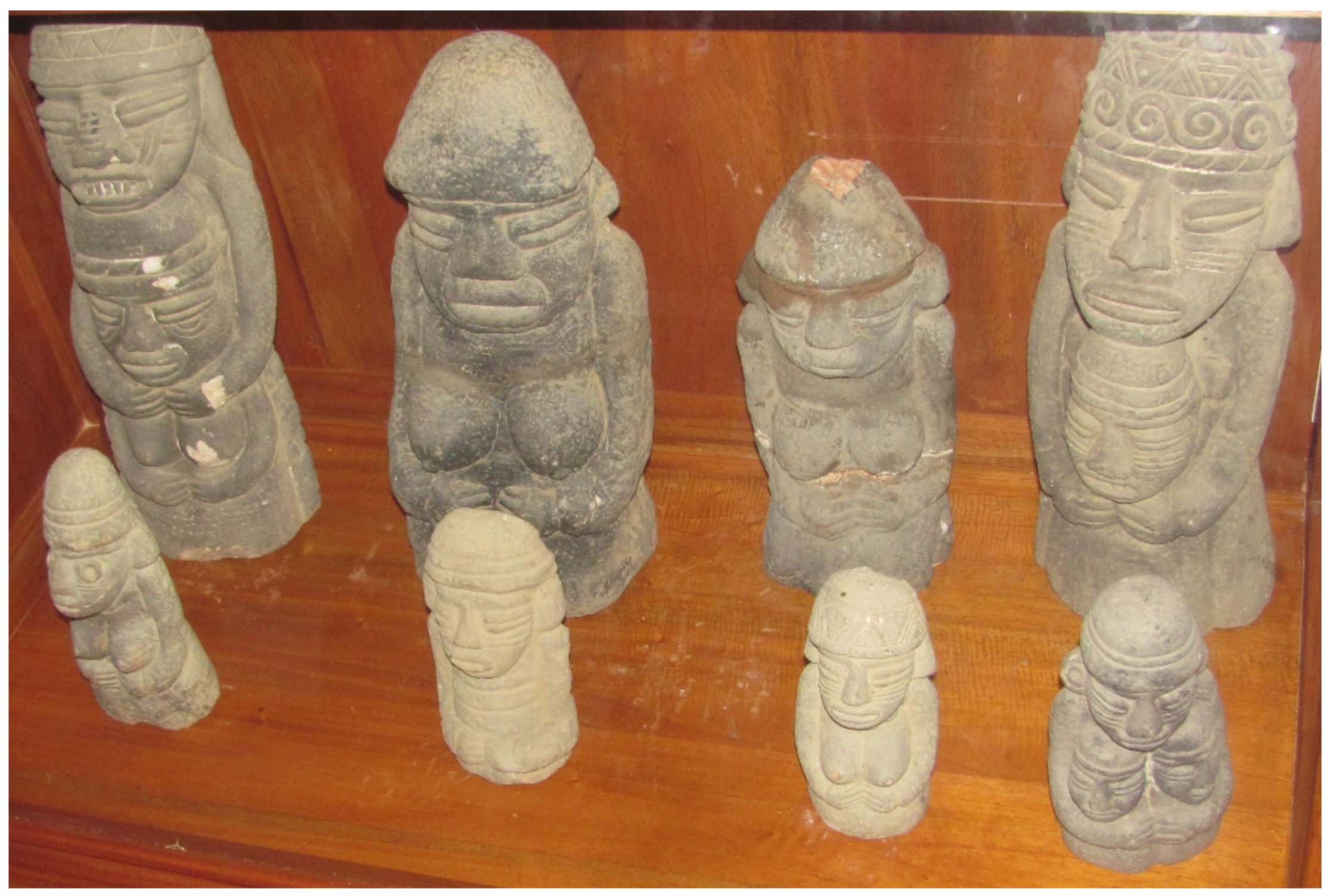
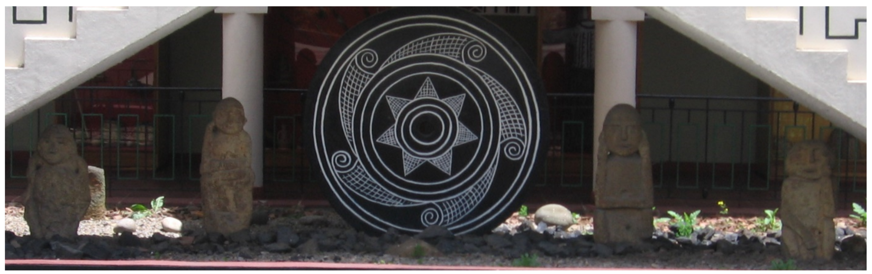
Aspects of the legend portrayed in eight unique portrait statues represent among the finest examples of Prehispanic stone carving known for the Muisca (Figure 14). Informant interviews indicate that most if not all statues come from near the Terrace Platform found at separate times since 1969. Produced by stone tools, these statues carved from local sandstone, limestone, and one granite—four statues are large—the largest measures a width of 18 cm and 50 cm tall—the smallest 12 cm wide and a height of 22 cm. At least two statues show a dark green patina or pigment and three damaged with impact scars resemble blows from a blunt instrument: one statue displays recent repairs for a break at the waist and damage to the head. All statues have post manufacture wear from exposure to the elements suggesting great antiquity.
There are twelve individuals represented (six males? and six females?), three adults appear to be deities holding one or two small children; all statues are three dimensional portraits of kneeling figures with the arms to the side, hands at the waist or below the children’s neck, with six digit fingertips touching. Other Muisca artistic conventions include short conical caps (gorros) with headbands and geometric decoration, no jewelry, and face painting or tattooing (1–3 horizontal lines) absent on two bare chested females and two children. Shamanistic animal imagery appears on two statues, one with a protruding face and goggle-like eyes and the other with fanged dentition and cross-lined cheek painting with nasal notches suggesting serpentine and feline transformation, respectively. All figures have closed mouths with thick lips except one child whose mouth is open suggesting speech or sound.
Stone statues found at terrace platforms are not without precedence for Highland Muisca archaeology. Eliecer Silva Celis [32], who excavated at El Infiernito, reported eight Muisca statues similar in style but slight larger on average (42–82 cm tall) at two terrace platforms exhibiting a pyramidal form on a ranch and salt works near La Salina de Mongua, an isolated, inaccessible highland riverine setting 120 km east of Villa. Atop an altered hilltop, he described platforms similar in size and form to the Terrace Platform with surrounding step terraces and canals connected to a pond or reservoir on the west side that still holds water together with two smaller statues (female). Six other statues recovered west of the platforms border a steep ravine. According to local informants, statues were originally sitting upright on the border of the platforms but moved by farmers searching for treasure. Although there is no published plan map of the site, reported are two retaining walls of stone masonry, a rough stone pavement, and boulder alignments in association with various recovered ceramic ocarinas, whistles, and caracoles fashioned into musical instruments. Interestingly, these kinds of artifacts also occur with the Leyva portrait statues. Four large Mongua statues on exhibit at the Suamox Archaeological Museum are exact replicas that show similar decorative symbols and motifs as the Leyva statues above (Figure 15). On the edge of the Muisca world isolated from Spanish domination, the Mongua site served as a native chiefdom well into the Colonial Period. Interpreted by Silva as a sacred religious temple or sanctuary like the Terrace Platform, the Muisca at Mongua continued traditional ceremonies and rituals related to a water, human fertility, and agricultural abundance until historic times [32] (212).
Importantly, the Leyva statues exhibit superior workmanship to the Mongua statues. This is not surprising because the Muisca of the Leiva Valley were famed stoneworkers who created the monuments at Infiernito and were responsible for Early Colonial buildings and other stone constructions at Villa. The Mongua temple, the Terrace Platform, and each site’s respective portrait statues represent Muisca religious architecture and artwork [32] (218) and themes of water and fertility closely tied to solar worship and origin myths. The Winter Solstice alignment of the solar observatory at Infiernito, the mountain temple at Villa, and hydraulic works underscore the practical and cosmological significance of water for agriculture. Human fertility symbolized by voluptuous female statues of Bachué, and images of children clearly recall the Legend of Iguaque. Additionally, like cultures of the ancient world, Muisca statues served as receptacles for receiving spirit essences of deities at sacred times and special places such as the sanctuaries of the Winter Solstice.
Two extraordinary gold figurines of cast tumbaga (lost-wax method) are Zenú- (or Sinú) style, displayed near the stone statues, also evoke Muisca imagery of Bachué and Iguaque (Figure 16a,b). At the Gold Museum in Bogotá, photos of these figures confirmed Zenú-style goldwork, one informant even commented that the museum had nothing quite like them, and the Zenú Gold Museum in Cartagena displays nothing similar either. While informants at Villa indicated that these artifacts were local, such pieces in Prehispanic times could have traded long-distance. It is known that Colombian goldsmiths (including the Zenú) were mobile artists who worked outside their home region [33] (39).
The Zenú lived in a rich and populous land on the plains of the Caribbean Lowlands and were famed goldsmiths in the 16th century who traded their goldwork widely across Colombia. Zenú goldsmiths were based at Zenufana, a site located in the Sinú River Basin and territory rich in gold [34]. It is uncertain if Zenú traders reached the Muisca highlands, but the Muisca are known to have traded regularly with other people along the lower Magdelena and Cauca rivers including the Tairona and Zenú cultures [31,35].
Zenú goldsmiths cast figures in a variety of animal forms but birds with big-beaks as ‘staff heads’ adorned with spiral motifs are most distinctive though human-deity-animal combinations are not common. Judging from the collection of Zenú gold figurines on display at the Bogota Gold Museum, kneeling female figures are rare. Kneeing female figures in ceramic, however, are common that highlight the importance of women in Zenú society [34]. The Leyva gold figure (~8 in tall) portrays a long-beaked bird-head attached to an elite or female deity body in a half crouched position holding a little boy in her outstretched arms. The boy wears jewelry and high-status headgear suggesting the young child Iguaque. A bare-breasted female body wears fine jewelry includes a necklace, a waistband with hanging ornaments, bracelets, armlets, and bangles on the thighs and ankles recalling the goddess Bachué and her association with creation and Mother Earth. A bird with a long downturned beak suggests a condor head attached to the human body of an earth goddess. While these figural combinations are unusual—the style of gold work is typical of the Zenú while the imagery is more characteristic of the Muisca. According to Muisca cosmology, following creation of the universe, giant condors breathed kernels of corn from their beaks symbolizing Astro guardians of the cardinal directions with the center occupied by Mother Earth and Father Sun [28] (146). Imagery associating sun, earth, and creation on this unique gold figurine is consistent with Muisca iconography.
The accompanying gold figurine (~5 in. tall) also cast tumbaga represents a female elite or deity identified by bare breasts in a crouched position bearing an urn vessel with a narrow orifice atop a cylindrical tumpline carrier. The vessel and carrier attached to a pleaded rope suspended from the forehead with both hands flat against the head. Her body dons elaborate body jewelry including a typical Zenú-style nose ornament and chin plug. Distinctive holed spirals decorate her headdress, arms, and legs and the body of the vessel. However, facial characteristics, particularly the eyes and nose, are Muisca-style closely resembling the female portrait statues suggesting a transcendental aspect of Bachué. The narrow hole in the urn vessel suggests a lime container or poporo used for chewing coca leaves, a widespread religious practice of narcotic consumption in South America. Lime removed by inserting a long sick or moistened dipper mixes with chewed coca leaves to extract the alkaloids in shamanistic rituals to achieve altered states of consciousness believed to facilitate communication with the spirit world, revered ancestors, and important deities.
Bachué believed to reappear on occasion was a principal goddess among the Muisca venerated for the benefits she bestowed upon humanity, and more importantly, to ensure her continued protection in times of societal stress. These special gold figurines, if commissioned by local Muisca leaders produced in the Zenú region, would have enhanced the spiritual value and religious importance of Bachué as a deity of creation and fertility. Identified with the Terrace Platform, such golden offerings would have memorialized a temple sanctuary dedicated to the Legend of Iguaque.

6. Conclusions

A Prehispanic Indigenous population at Villa now appears certain but requires greater research attention. Today, the citizens of Villa assume that the first inhabitants of the city were the victors of Spanish Conquest in the Eastern Andean Highlands. A simple yet crucial question arises: who really built the Early Colonial city? The answer is the same people who were already living there perhaps for centuries. Preliminary data indicate residential settlement and intensive agriculture along the city’s waterways near the headwaters of the Rio Leyva on the west side of town where modern development is less intrusive. Here, raised-ridged fields, step terracing, and potential residential settlement associate with intensive cultivation suggesting a Prehispanic farming community practicing irrigation on highly productive soils. It is even possible that the Muisca laid much of the hydraulic infrastructure prior to the construction of Spanish water works transforming Villa and its environs into a wheat breadbasket for the Viceroyalty of Nueva Grenada.
The Terrace Platform and Infiernito were two important sanctuaries among the Muisca signifying a cosmic relationship between the sun and water in both real and ritual terms. The precise alignment of stone columns to a distant water temple below the Winter Solstice sunrise also included stations along the way suggesting a ritual processional pathway timed to commemorate the end of the solar year and renewal of agricultural cycle. Born from a sacred mountain, water journeyed around the Terrace Platform into the Quebrada San Agustín, rainfall on the Temple Platform channeled into a ceremonial reservoir flanked by terraces, and canalized mountain water traveled long-distance from the opposite direction. These diverse mountain waterways eventually emptied into the Rio Leyva on its westward journey towards the observatory, a symbol of fertility and solar power, where along the way irrigation agriculture would help sustain human fertility and renewed life under environmental conditions of rapid climate change.
The Terrace Platform’s shaped and natural stone boulders correspond to ceremonial architecture at Muisca sites in Tunja, la Salina de Mongua, and, of course, at Infiernito [32,36,37]. A temple platform with stone terraces and hydraulic features represents a strategic ceremonial-ritual complex on a processional route. Connected to the observatory with intervening ritual stations along the way included natural water sources as well as a notable monolith shrine in the Parque Nariño an alleged Prehispanic marketplace and/or chiefly compound. Indeed, markets and trade were key features of Muisca economic life that often took place within palisaded compounds of important chiefs but also could occur at special public settings; market activity and religious ceremony were frequently indistinguishable [14]. For example, Chibchacum the Muisca god of order, justice, and patron deity of merchants was identified with sanctuaries dedicated to marketing. In such places economic interactions occurred with people who were culturally affiliated but also included exchanges with foreigners in places that involving ceremony and political activity of high ranking chiefs [31,35]. Interestingly, the Saturday farmer’s market in Villa located just below the grounds of the Hospederia Duruelo Convention Center near the Terrace Platform still reflects such cultural diversity. This weekly community-wide event sponsored by civic political and religious elites promotes various socioeconomic activities for persons of national status and foreign origin (Figure 17a).
Between the Quebrada San Agustín and city marketplace is a wooded area with boulder megaliths in front of the Terrace Platform on the Winter Solstice azimuth (Figure 17b). With no natural access to the platform, solar pilgrims needed a gathering place to witness the sun rising over Terrace Platform and Iguaque paramount. Curiously, this vantage point near the city market is rumored to have been an ancient cemetery. While there are no reported graves, cemeteries are not characteristic apart from Muisca settlements, ceremonial offerings here could represent receptacles for receiving the spirit essences of important deities.
Such potential offerings include the stone portrait statues and tumbaga figures allegedly associated with the Terrace Platform; all portray religious symbolism recalling the myth and legend of Iguaque and Bachué. Gold figurines cast in a non-Muisca style produced in a foreign land like the Zenú region and traded long-distance would enhance their value and spiritual potency. Stone portrait statues in typical Muisca-style made from local materials but representing the finest stone working in the Eastern Andean Highlands became ritually charged and ceremonially powerful when displayed near the Terrace Platform.
A Native American community at Villa has profound implications for understanding settlement systems in the Leiva Valley. The chiefdom of Zaquenzipá centered at Infiernito linked to outlier communities like Villa below the Cerro Morro Blanco suggests that chiefly authority extended regionally beyond the settlement limits of the monumental observatory. This agency appears both economic and religious in nature but among the Muisca it is difficult to separate social, political, and economic components from ideology—inextricably linked—but this is also true of even the most complex state societies in the Americas like the Maya, Aztec, and Inca [1, cf. 2]. Moreover, research in the Leiva Valley has not addressed the structural role of the environment even though dual wet and dry seasons vary, drought is common, and farming without irrigation is marginal at best. The work here shows that cultural aspects of the Muisca including religious ideology are fundamentally related to the natural environment, a dimension of all sociocultural situations.
Our research into chiefdom ecodynamics contributes archaeological information on intensive agriculture and water management among the original inhabitants of Villa. Indeed, hydraulic systems and religious activity in the Leiva Valley are closely tied to a mountain water temple at Villa, the astronomical-meteorological observatory at Infiernito on the Winter Solstice, and intervening stations for a processual pilgrimage route. Such solar events and water mountains embodied times and places of cosmic ontogeny and ancestral origin. For the Muisca, the cosmology of fertility and environment of water were inseparable in that they saw no distinction or inconsistency between the physical and spiritual realms or actual or perceived aspects of their world. The economic uncertainties resulting from drought, flooding, and erosion leading to famine were real and sobering requiring both tangible and intangible responses to combat challenges posed by their natural environment. In effect, people were doing everything possible to mitigate the social and economic effects of water shortages even employing a cosmological system as a means for ideological control.
Ecodynamic study explores the full-range of human adaptive abilities under conditions of environmental stress to determine how intermediate-level societies like the Muisca confronted rapid climatic change, a question underexplored in the archaeology of the Eastern Andean highlands. New perspectives of the Muisca will provide insight into chiefdoms, diverse forms of subsistence agriculture in Highland Colombia, and how the Muisca incorporated cosmology into the natural environment. Additionally, this study gives voice to people that time has forgotten revealing the first inhabitants of a beautiful place that would become a charming and notable colonial town.

Funding

This research funded by a grant from the National Geographic-Waitt Foundation (W352-14), contributions to the Foundation for Americas Research, Inc., and support from the University of Texas at Austin.

Institutional Review Board Statement

Not applicable.

Informed Consent Statement

Not applicable.

Data Availability Statement

Not applicable.

Acknowledgments

This paper benefited by the critical comments of two anonymous reviewers, but any deficiencies are the sole responsibility of the author. I would like to thank the Awazako Family for their assistance in beginning the preliminary project near El Infiernito. I appreciate the expertise and valuable services of Timothy Beach, Eric Weaver, Luisa Aebersold, Greta Wells, Beth Cortwright, Nikki Woodward, Pedro Luis Suárez, Pilar Suárez Smyth, and Martha Esperanza Suárez. Additionally, the people of the City of Villa de Leyva, especially the staff at the beautiful Hospederia Duruelo, were most cordial in making our time there memorable.

Conflicts of Interest

The author declares no conflict of interest.

References

  1. Boada, R.A.M. Control Sobre Tierras, Sistemas de Camellones, Canales, y Mono de Obra Durante el Periodo Prehispánico en la Sabana de Bogotá, Colombia. Lat. Am. Antiq. 2018, 29, 660–680. [Google Scholar] [CrossRef]
  2. Langebaek, C.H. Los Muiscas: La Historia Milenaria de un Pueblo Chibcha; DEBATE: Bogotá, Columbia, 2019; ISBN 978-958-5446-60-1. [Google Scholar]
  3. Botiva, H.A. La altiplanicie cundiboyacense. In Colombia Prehispánica-Regiones Arqueológicas; Botiva, H.A., Cadavid, G., Fernanda, H.L., de Groot, M.A.M., Mora, S., Eds.; Instituto Colombiano de Antropología: Bogotá, Colombia, 1989; pp. 77–115. [Google Scholar]
  4. Langebaek, C.H. Arqueología Regional en el Valle de Leiva: Procesos de Ocupación Humana en Una Región de Los Andes Orientales de Colombia; Colección Informes Antropológicos; Instituto Colombiano de Antropología e Historia: Bogotá, Colombia, 2001; ISBN 958-97054-2-1. [Google Scholar]
  5. Smyth, M.P. Monumental Architecture, Settlement Landscape, and Climate Change at El Infiernito, Colombia. J. Humanit. Arts Soc. Sci. 2021, 5, 89–110. [Google Scholar] [CrossRef]
  6. Salge, F.M.S. Festejos Muiscas en el Infiernito, Valle de Leyva: La Consolidación del Poder Social; Universidad de los Andes: Bogotá, Colombia, 2007; ISBN 978-958-695-287-3. [Google Scholar]
  7. Ariza, Fr.A.E.S.O.P. Provincial de los Dominicos, Bogotá, Mayo 1° de 1957. Unpublished manuscript, Bogotá.
  8. Pinzón, B.R. Arte Religiosa en Villa de Leyva. In Villa de Leyva Historia y Legado, Bicentenario de la Consolidación del Congreso Nacional; Reyes, M.E., Arenas, V.V., Eds.; Villa de Leyva: Bogotá, Colombia, 2012; pp. 75–104. [Google Scholar]
  9. Reyes, M.E. Imán Geográfico, Histórico y Cultural de Villa de Leyva. In Villa de Leyva Historia y Legado, Bicentenario de la Consolidación del Congreso Nacional; Reyes, M.E., Arenas, V.V., Eds.; Villa de Leyva: Bogotá, Colombia, 2012; pp. 50–69. [Google Scholar]
  10. Kruschek, M.H. The Evolution of the Bogota Chiefdom: A Household View. Ph.D. Thesis, University of Pittsburgh, Pittsburgh, PA, USA, 2003. [Google Scholar]
  11. Broadbent, S.M. A Prehistoric Field System in Chibcha Territory, Colombia. Ñawpa Pacha 1968, 6, 135–147. [Google Scholar] [CrossRef]
  12. Boada, R.A.M. Patrones de Asentamiento Regional y Sistemas de Agricultura Intensiva en Cota y Suba, Sabana de Bogotá, (Colombia); FIAN, Banco de la Republica: Bogotá, Colombia, 2006. [Google Scholar]
  13. Boada, R.A.M. The Evolution of Social Hierarchy in a Muisca Chiefdom of the Northern Andes of Colombia; University of Pittsburgh Memoirs in Latin American Archaeology No. 17; University of Pittsburgh: Pittsburgh, PA, USA, 2007; ISBN 987-1-877812-83-5. [Google Scholar]
  14. Langebaek, C.H. Mercados, Poblamiento e Integración Étnica Entre Los Muiscas, Siglo XVI; Coleccíon Bibliográfica, Banco de la República: Bogotá, Colombia, 1987. [Google Scholar]
  15. Restrepo, V. Los Chibchas Antes de Los Conquista Española-Atlas y Anexo Arqueológicos; Biblioteca Banco Popular: Bogotá, Colombia, 1885; republished 1972. [Google Scholar]
  16. Pacheco, K.G.M. Prácticas Agrícolas Coloniales Y Degradación del Suelo: El Caso de Saquencipá. Rev. Geogr. Am. Cent. 2011, 2, 1–14. [Google Scholar]
  17. Pacheco, K.G.M. Livestock Farming in the Saquencipá Valley, New Kingdom of Granada, Colombia in the 16th and 17th Centuries. Pastos 2012, 42, 251–272. [Google Scholar]
  18. Pacheco, K.G.M. Prácticas Agropecuarias Coloniales y Degradación del Suelo en el Valle de Saquencipá, Provincia de Tunja, Siglos XVI y XVII; Universidad Nacional de Colombia: Bogotá, Colombia, 2015. [Google Scholar]
  19. Langebaek, C.H. Words, Things, and Text: El Infiernito, Archaeology, Documents and Ethnology in the Study of Muisca Society. In Against Typological Tyranny in Archaeology: A South American Perspective; Gnecco, C., Langebaek, C., Eds.; Springer: New York, NY, USA, 2013; ISBN 1461487234. [Google Scholar]
  20. Heckenberger, M.; Neves, E.G. Amazonian Archaeology. Annu. Rev. Anthropol. 2009, 38, 251–266. [Google Scholar] [CrossRef] [Green Version]
  21. Berrío, J.C.; Boom, A.; Botero, P.J.; Herra, L.F.; Hooghiemstra, H.; Romero, F.; Sarmiento, G. Multi-disciplinary evidence of the Holocene history of a cultivated floodplain in the wetlands of northern Colombia. Veg. Hist. Archaeobotany 2001, 10, 161–174. [Google Scholar] [CrossRef]
  22. Smyth, M.P.; Beach, T.S.; Weaver, E.M. Climate Change and Chiefdom Ecodynamics in the Eastern Andean Cordillera of Colombia. In Changes in Latitudes, Changes in Attitudes: Transitions and Thresholds throughout Central America and Beyond; Aebersold, L., Samantha, M.K., Eds.; Occasional Papers, Number 21; the Center for Archaeological and Tropical Studies, University of Texas-Austin: Austin, TX, USA, 2016; pp. 15–32. [Google Scholar]
  23. Smyth, M.P. Chiefdom Ecodynamics and Muisca Cosmology in the Valley of Leiva, Highland Colombia. Glob. J. Hum. Soc. Sci. Res. 2017, 17, 21–45. [Google Scholar]
  24. Cárdenas, A.F. Datos Sobre la Alimentación Prehispánica en la Sabana de Bogotá, Colombia. In Informes Arqueológicos de Instituto de Antropología e Historia, No. 3; Instituto de Antropología e Historia: Bogotá, Colombia, 2002. [Google Scholar]
  25. Galeano, R.D.I. Trigo y Molinos: Pequeña Introducción y su Incidencia en Villa de Leyva. In Villa de Leyva Historia y Legado, Bicentenario de la Consolidación del Congreso Nacional; Reyes, M.E., Arenas, V.V., Eds.; Villa de Leyva: Boyacá, Colombia, 2012; pp. 227–233. [Google Scholar]
  26. Smyth, M.P. Hydraulic Chiefdoms in the Eastern Andean Highlands of Colombia. Heritage 2018, 1, 100–121. [Google Scholar] [CrossRef]
  27. Puleston, D.E. Terracing, Raised Fields, and Tree Cropping in the Maya Lowlands: A New Perspective on the Geography of Power. In Pre-Hispanic Maya Agriculture; Harrison, P.D., Turner, B.L., Eds.; University of New Mexico Press: Albuquerque, NM, USA, 1978; pp. 225–254. ISBN 0-8262-0483-4. [Google Scholar]
  28. Ingativa, N.X. Resignación Cosmogónica Muisca Chibcha en el Valle de Zaquenzipá. In Villa de Leyva Historia y Legado, Bicentenario de la Consolidación del Congreso Nacional; Reyes, M.E., Arenas, V.V., Eds.; Villa de Leyva: Boyacá, Colombia, 2012; pp. 137–159. [Google Scholar]
  29. Villarte, S.G. Tunja Prehispánica; Colciencias-Universidad Pedagógica y Tecnológica de Colombia: Tunja, Columbia, 2001. [Google Scholar]
  30. Pradilla, R.H.O.; Villate, S.G. Pictografías moyas y rocas del Farfacá; Museo Arqueológico de Tunja, UPTC-Gobernación de Boyacá, Buho Ediciones: Tunja, Columbia, 2010. [Google Scholar]
  31. Simón, F.P. Noticias Historiales de las Conquistas de Tierra Firme en las Indias Occidentales; Biblioteca del Banco Popular: Bogotá, Colombia, 1625; republished 1981. [Google Scholar]
  32. Silva, C.E. Las Estatuas de la Salina de Mongua. Sep. Rev. Educ. 1968, 6, 147–162. [Google Scholar]
  33. Bray, W. The Gold of El Dorado; The Royal Academy: London, UK, 1978. [Google Scholar]
  34. Plazas, C.; Falchetti, A.M. Asentamientos Prehispánicos en el bajo río San Jorge. In Fundacíon de Investigaciones Arqueológicas Nacioneales; Banco de la República: Bogotá, Columbia, 1981. [Google Scholar]
  35. Castellanos, J.D. Elegías de Varones Ilustres de Indias, Part 4. In Historias del Nuevo Reino de Granada; Editorial ABC: Bogotá, Columbia, 1955. [Google Scholar]
  36. Silva, C.E. Investigaciones arqueológicas en Villa de Leiva. Boletín Mus. Del Oro. 1981, 10, 1–18. [Google Scholar]
  37. De Alba, G.H. El templo de Goranchacha. Rev. De Las Indias 1937, 2, 10–18. [Google Scholar]
Figure 1. Map of Colombia, South America, and the Department of Boyacá with an inset showing the locations of Valley of Leiva, the site of El Infiernito, the village of Monquirá, and town of Villa de Leyva, as well as other towns/sites throughout valley.
Heritage 05 00194 g001
Figure 2. Southeast view of the Cerro Morro Negro and Iguaque mountains towering over the city of Villa de Leyva.
Heritage 05 00194 g002
Figure 3. East view of the Colonial heart of Villa de Leyva showing the Plaza Mayor, the Parroquial de Nuestra Señora Santa Maria de Leyva, and the Casa de Juan de Castellanos (left) with the Cerro Santo just left of the chapel belfry and the larger Cerro Morro Negro in the background.
Heritage 05 00194 g003
Figure 4. Photo looking east-southeast towards the paramount of the Cerro Morro Negro showing the mountain water fissures feeding stream channels adjacent to the Terrace Platform where the Quebrada San Agustín originates and where the Winter Solstice sun rises on 21 December.
Heritage 05 00194 g004
Figure 5. (a) Photos of the Spanish Canal along the base of the Cerro Morro Negro foothill just north of where water enters the Terrace Platform Complex; (b) a principle water fall for the Spanish Canal close to the diversion channel for the Molino la Mesopotamia.
Heritage 05 00194 g005
Figure 6. (a) The Quedrada San Agustín downstream from the Terrace Platform one block northeast of the Plaza Mayor; (b) The Puente de San Agustín adjacent to Early Colonial buildings.
Heritage 05 00194 g006
Figure 7. Google Earth satellite imagery of the San Francisco aldea showing modern raised-ridged fields south of the Quebrada (stream) Cucobos (upper left) and circular features (dark spots in the field) or house foundations (uta) along a buried wagon? road leading to a ruined stone structure (center right). The yellow-white highlights are modern roads.
Heritage 05 00194 g007
Figure 8. (a) Google Earth satellite imagery of raised-ridged fields and pump houses near the junction of Quebradas Cucobos and La Picona (center-left). The yellow highlight in the upper right corner marks a modern road; (b) Photo of raised fields that parallel irrigation canals connected to cement block pump houses along the Quebrada Cucobos.
Heritage 05 00194 g008aHeritage 05 00194 g008b
Figure 9. (a) Google Earth aerial view of west Villa de Leyva and the Quebrada La Picona showing step terraces with possible earlier, larger systems extending out from both sides (center right) in front of a possible residential group in an open green field (top center); (b) Close-up photo of step terraces with brick retaining walls atop cobblestone bases near La Picona.
Heritage 05 00194 g009aHeritage 05 00194 g009b
Figure 10. (a) Goggle Earth Street View looking east of a potential raised field along Calle 12 and La Picona looking west (center-bottom) showing a diagonal feeder? canal now partially buried (center). The white highlights show modern roads including Calle 12 (center); (b) north view of La Picona stream channel along the margin of a raised field surface; (c) Level field surface now being used as pasture; (d) Goggle Earth Street View of road cut profile at Calle 12 showing stratigraphic sediment layers superimposed upon a red stone fill or platform typical of raised fields elsewhere.
Heritage 05 00194 g010aHeritage 05 00194 g010b
Figure 11. (a) Upright natural stone megalthic in the Parque Nariño precisely aligned with the Winter Solstice between Infiernito and the Terrace Platform; (b) Close-up of a huge megalthic shirine of apparent tuffaceous dolomite or marine stone in a place alleged to be a Prehispanic marketplace and pilgrimage station.
Heritage 05 00194 g011
Figure 12. (a) Google Earth satellite image showing a proposed pilgrimage route (yellow line) and intervening stations (red points) following the Winter Solstice azimuth from Infiernito at bottom crossing the Rio Leyva near the Casa Antares to the Terrace Platform at the top (GPS pins) with three ritual stations along natural water sources as well as the Parque Nariño monument near the center of Villa de Leyva; (b) Water hole near the Hotel Casa de los Fundadores just west of Villa de Leyva; (c) Stone megaliths associated with the same water source; (d) Megaliths recently repositioned at a pond feature on the road to Infiernito.
Heritage 05 00194 g012aHeritage 05 00194 g012b
Figure 13. (a) Topographic-planimetric sketch map of the Terrace Platform Complex and hydrology showing the Quebrada (stream) San Agustín (Q. S. A.) and canals; (b) Photo of the former drainage canal by a circular stone alignment designed to collect rainwater from the Terrace Platform discharged into a potential reservoir now supporting the Casa de Medina; (c) Photo of the megalithic terrace tiers along the west side of the Terrace Platform. Dry stone masonry with abundant chinking stones produced Prehispanic and Early Colonial ceramics; (d) A faced stone opening about midway along the north masonry wall aligns with the boulder megalith (below) and the Infiernito Observatory on the Winter Solstice; (e) Massive boulder megalith or shrine anchoring the west masonry wall that lies directly above a lime marl chamber.
Heritage 05 00194 g013aHeritage 05 00194 g013b
Figure 14. Photo of eight carved limestone, sandstone, and granite (lower right) portrait statues from a private collection exhibiting typical Muisca decorative symbols and motifs. These statues allegedly found near the Terrace Platform appear to be deity or elite figures associated with fertility (Bachué) and the origin myth of Iguaque.
Heritage 05 00194 g014
Figure 15. Photo of four Muisca stone portrait statues (replicas) flanking a large black stone white incised disc (modern artwork in native style) at the Archaeological Museum of Suamox in Sogamosa. The originals statues found near the flanks of terrace platforms at Salinas de Mongua are like those reported near the Terrace Platform in Villa de Leyva.
Heritage 05 00194 g015
Figure 16. (a) Cast tumbaga female figurine (~8 in. tall) of a deity with a long-beaked bird head (condor?) holding a boy child (Iguaque) showing Zenu-style gold working on display at Villa de Leyva; (b) Zenu-style cast tumbaga female figurine (~5 in. tall) with Muisca motifs evoking imagery of Bachué carrying a trump line vessel or lime container (poporo) for chewing coca leaves.
Heritage 05 00194 g016
Figure 17. (a) Photo of the traditional Saturday market at Villa de Leyva looking west; (b) Sun rise over Cerro Morro Negro, the Terrace Platform, and proposed gathering place for Muisca solar pilgrims as seen on 21 December 2021, or day of the Winter Solstice.
Heritage 05 00194 g017
Publisher’s Note: MDPI stays neutral with regard to jurisdictional claims in published maps and institutional affiliations.

