
An Interpretive Ruination Model of the Built Heritage in Inner Areas: The Case Study of the Neighbourhood Granfonte in Leonforte


Abstract
:1. Introduction
- Section 2 proposes a survey of the ruination phenomenon of the built heritage in historical centres;
- Section 3 introduces the case study of the Granfonte neighbourhood in Leonforte in the metropolitan area of Enna;
- Section 4 illustrates the methodological approach;
- Section 5 reports the results;
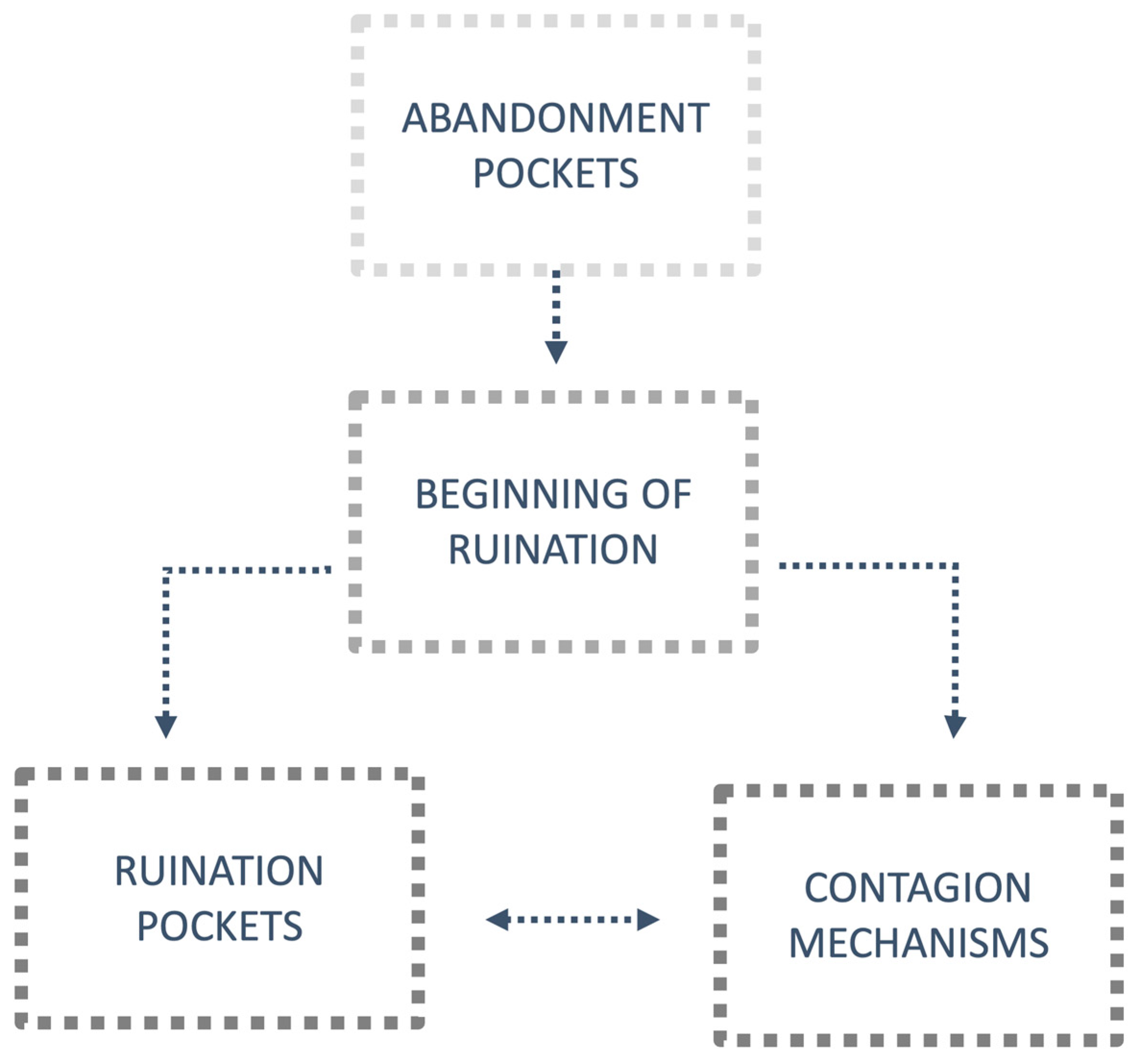
- Section 6 proposes some reflections on the results, i.e., on the phenomena detected, namely abandonment pockets, ruination pockets, and the contagion mechanisms of the ruination among building units. The section also identifies the limits and lines of future development of this research;
- Section 7 summarises the main points of the proposed research.
2. Approaches to the Ruination Phenomenon of the Built Heritage
3. Materials
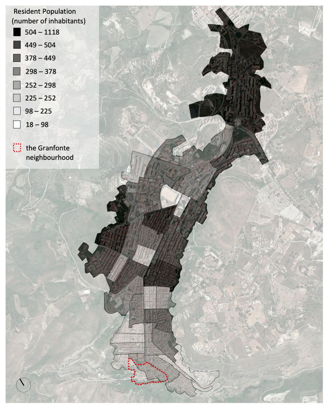
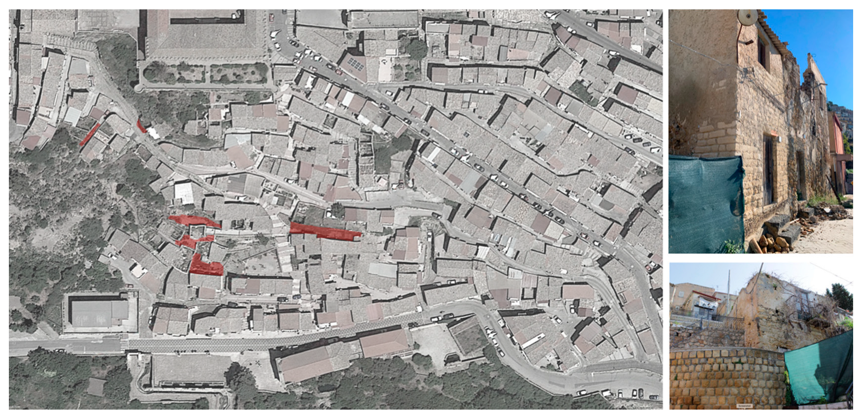
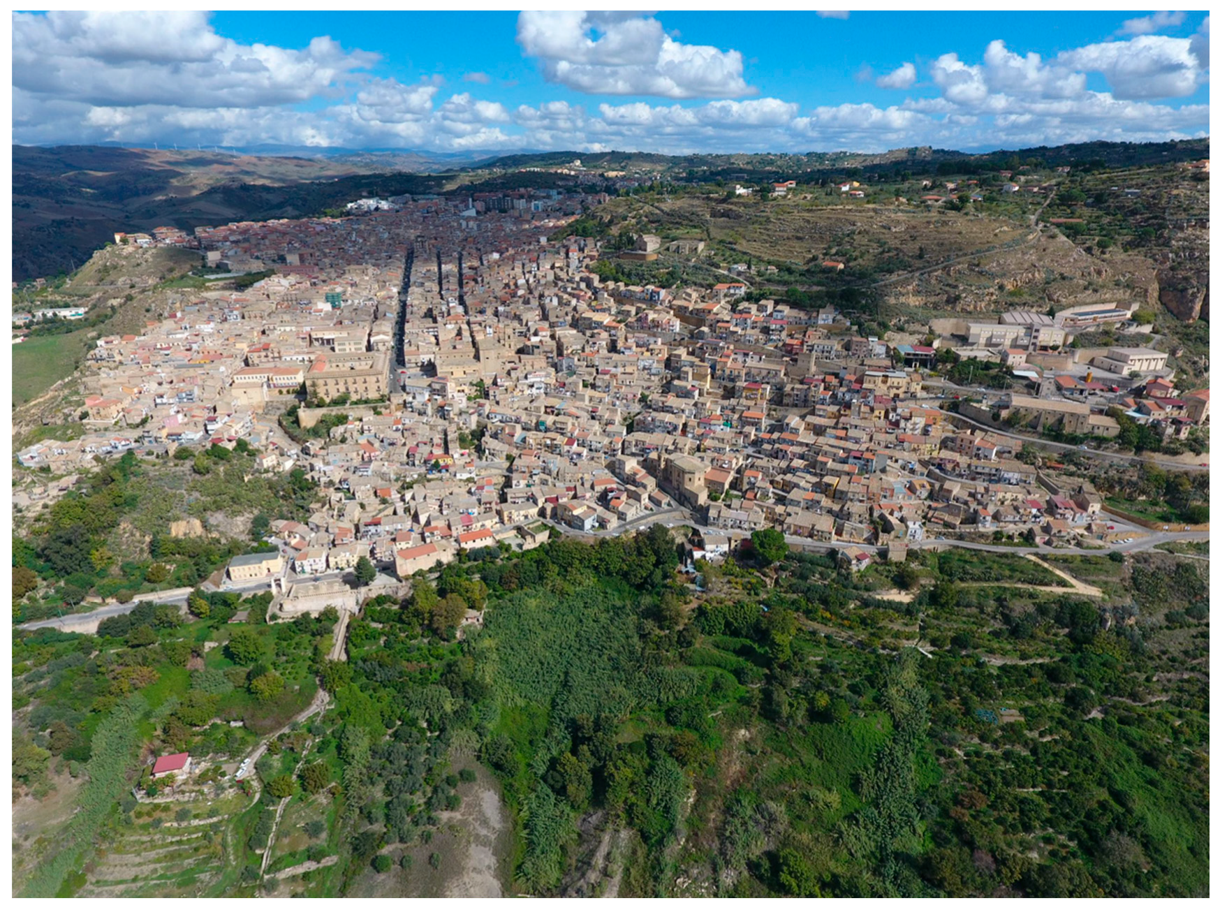
3.1. The Case Study: The Granfonte Neighbourhood in Leonforte
3.2. Urban and Building Characteristics of the Granfonte Neighbourhood: The Relationship with the Orography and the Dwelling Characteristic
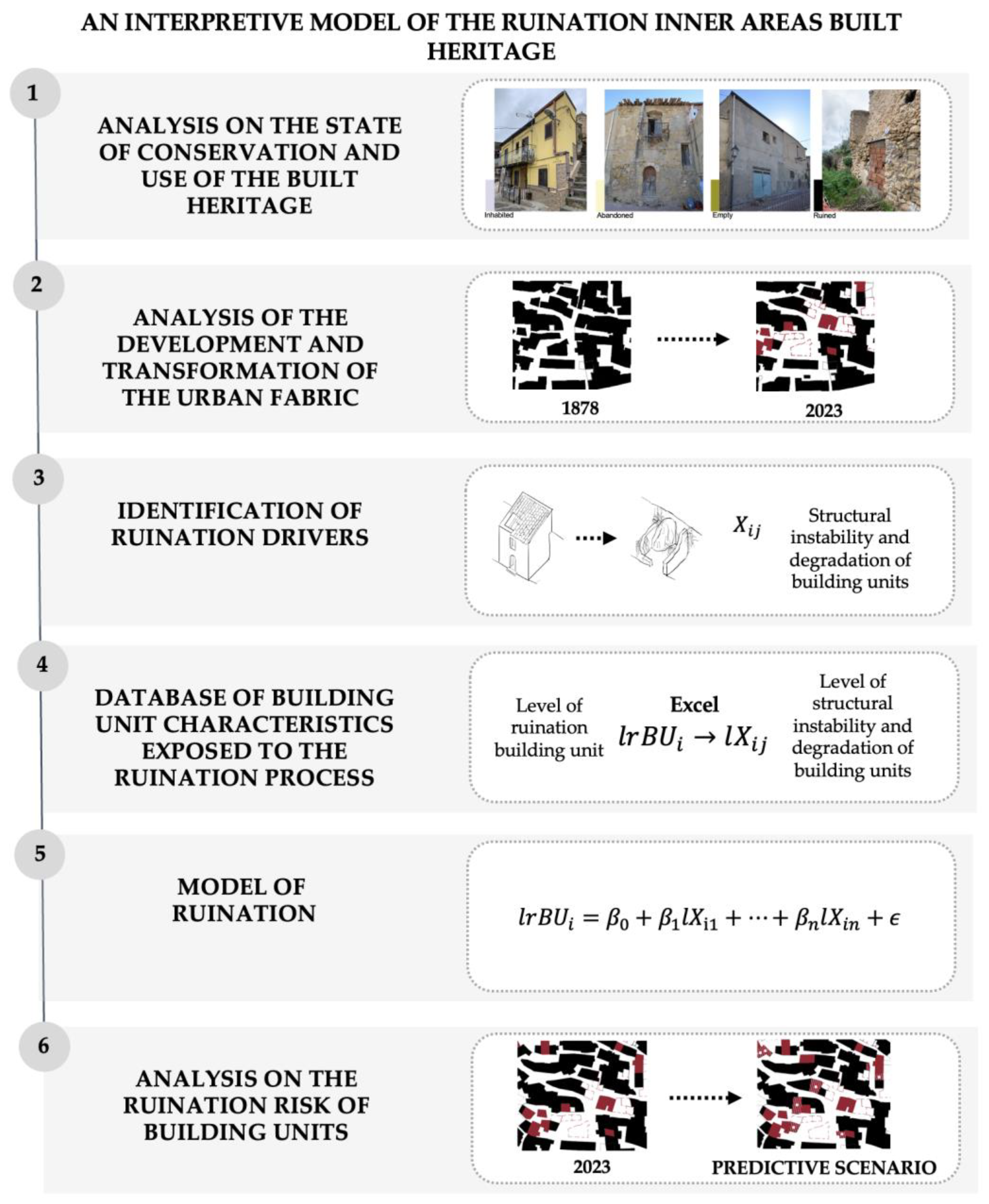
4. Methods
- Analysis of the state of conservation and use of the built heritage;
- Analysis of the development and transformation of the urban fabric;
- Identification of the ruination phenomenon drivers;
- Construction of a database for the characteristics of building units exposed to the ruination process;
- Modelling of the ruination phenomenon for the building units based on a multivariate regression model;
- Ruination risk analysis of the building units;
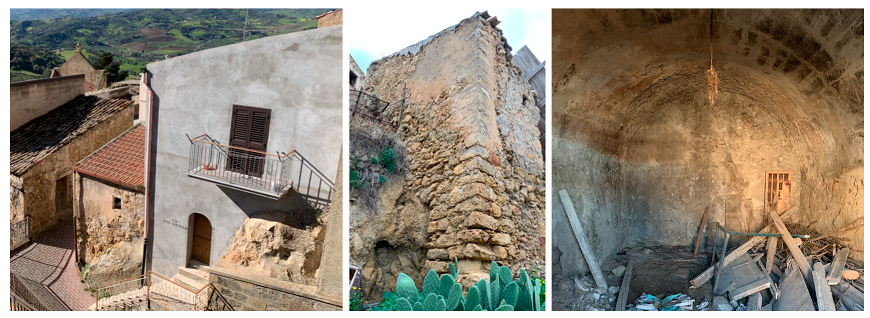
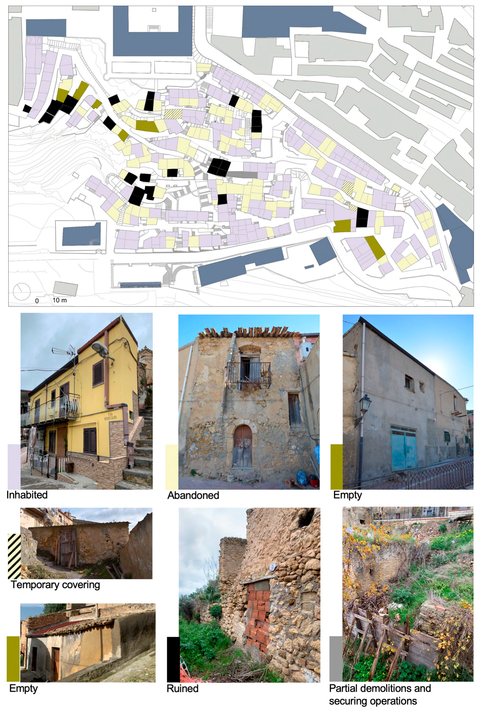
4.1. Analysis of the State of Conservation and Use of the Built Heritage
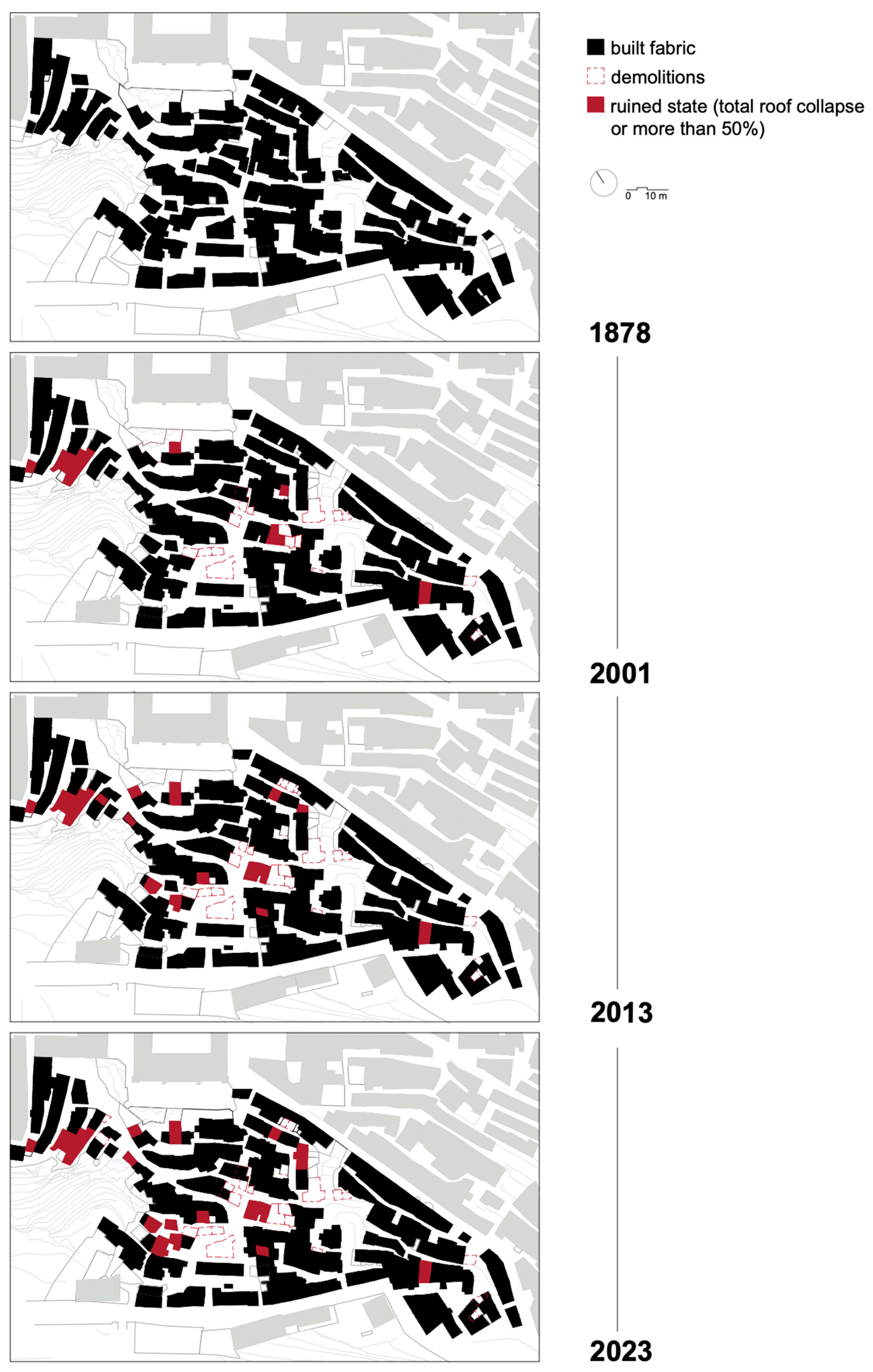
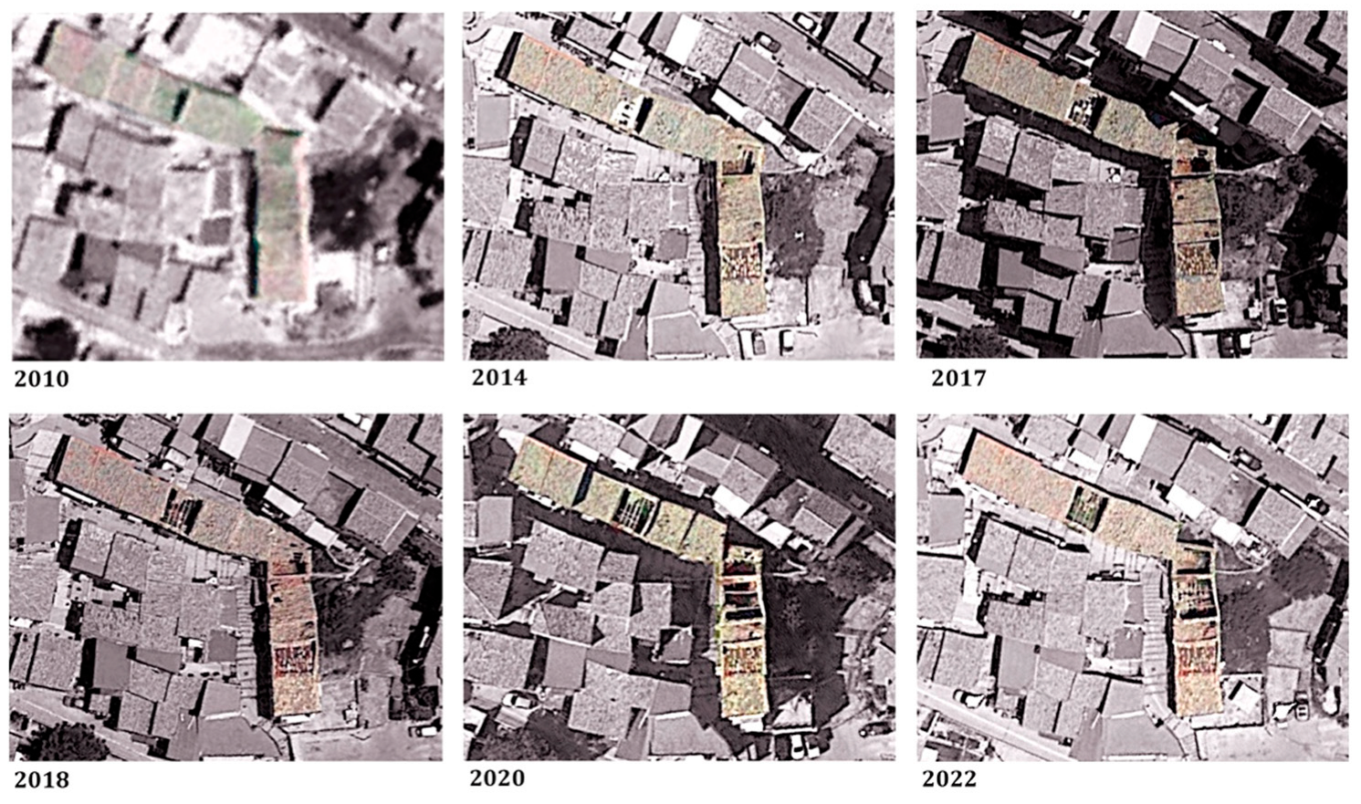
4.2. Analysis of the Development and Transformation of the Urban Fabric
4.3. Identification of the Ruination Phenomenon Drivers
4.4. Construction of a Building Units Characteristics Database Exposed to the Ruination Process
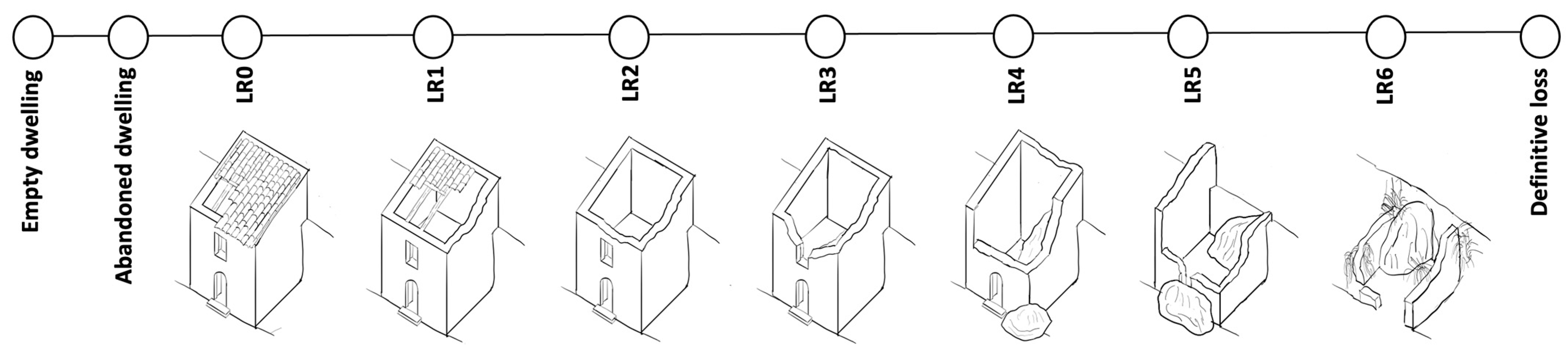
4.5. Modelling of the Ruination Phenomenon and Ruination RISK Analysis
5. Results
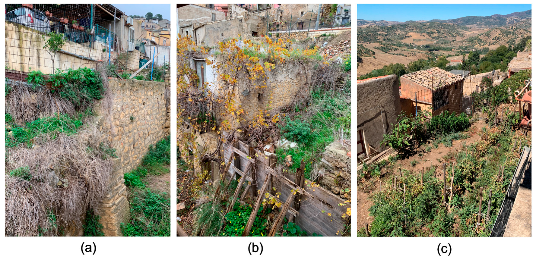
5.1. The Problematic Nature of Abandonment
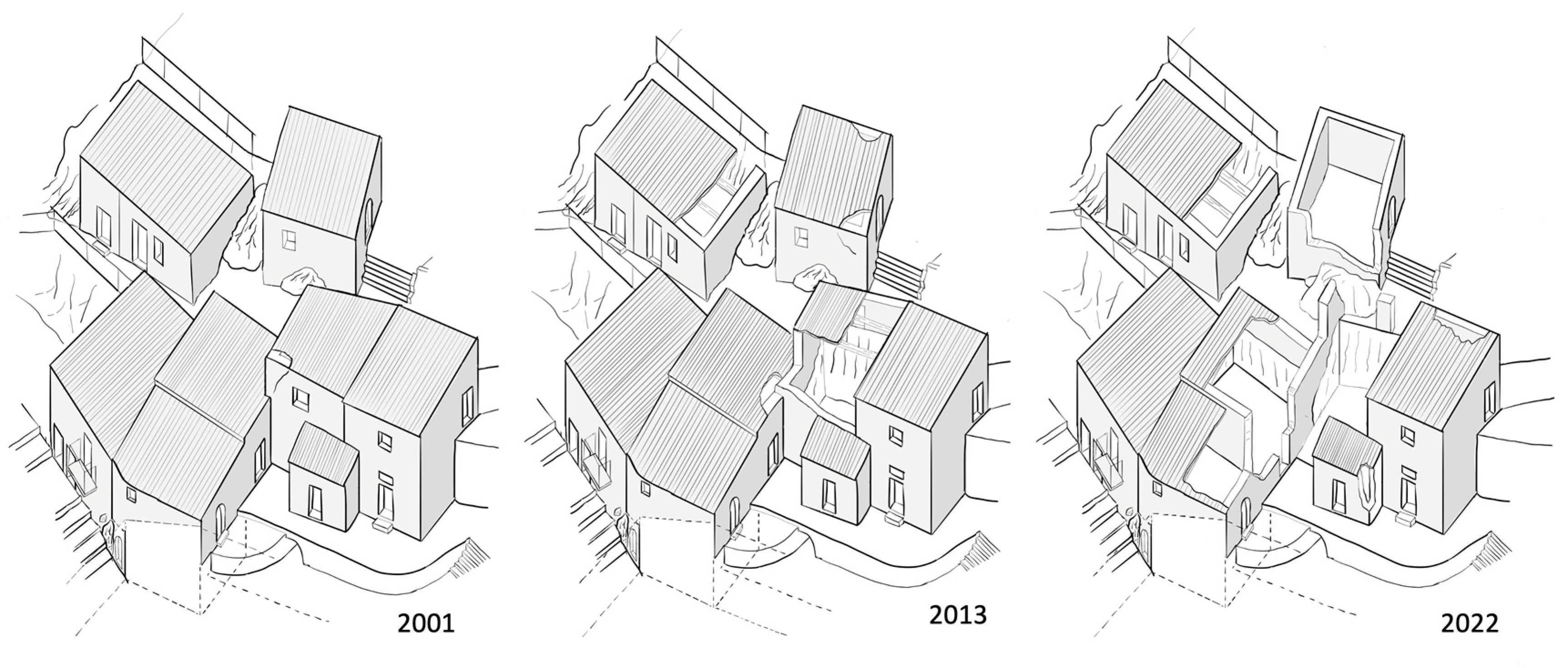
5.2. The Loss of Built Fabric: Ruination and Demolition
5.3. Drivers of Ruination
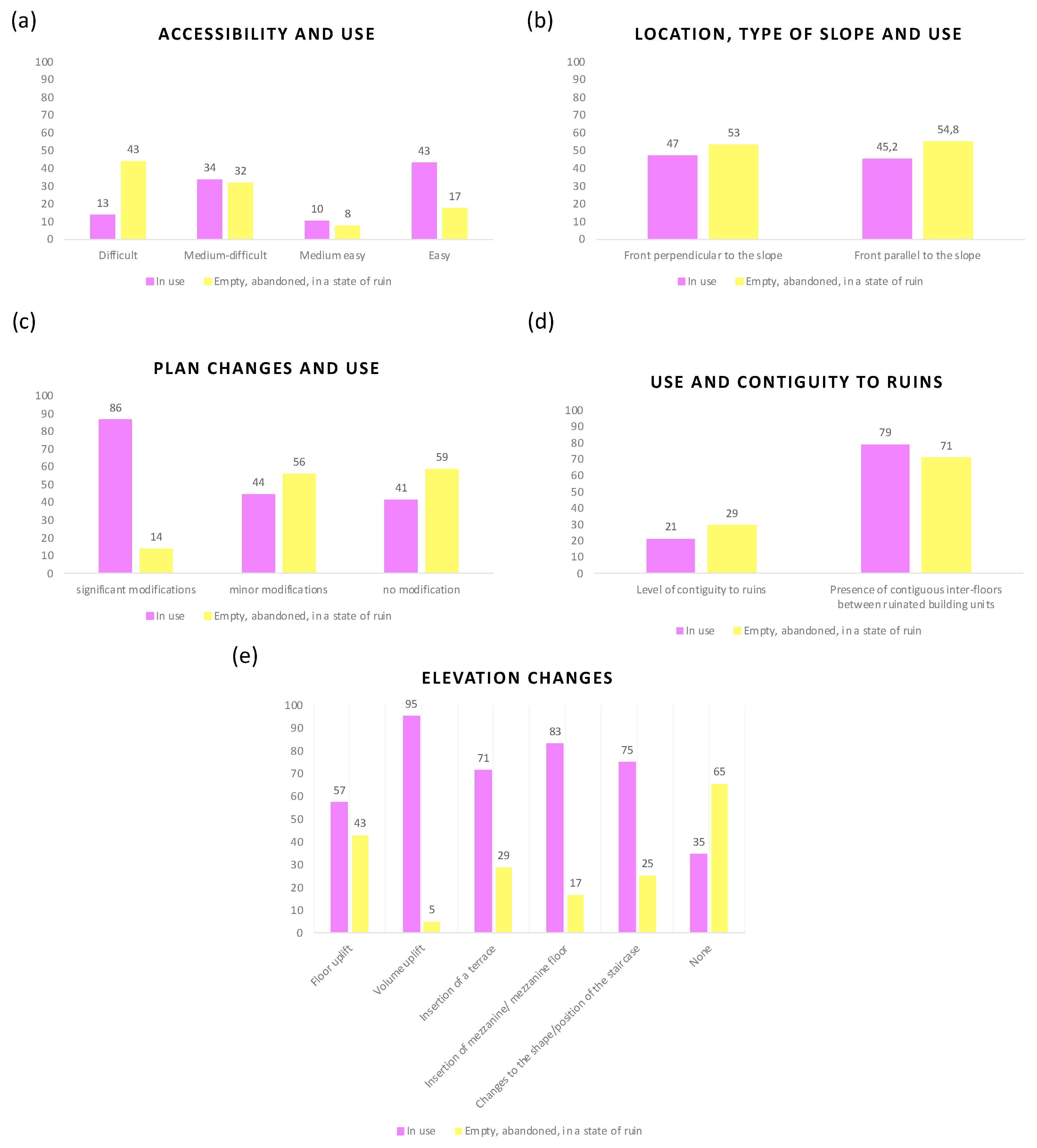
5.4. Database of the Characteristics of Building Units Exposed to the Ruination Process
- Typological characteristics—period of construction: score 1—buildings before 1878; score 6—buildings after 2005;
- Typological characteristics—B.U. layout related to the aggregate: score 1—isolated; score 2—corner; score 3—at the end; score 4—interlocked;
- Typological characteristics—B.U. layout related to the proportions of the slope: score 1—substantial slope; score 2—steep slope; score 3—moderate slope;
- Typological characteristics—B.U. position related to the slope: score 1—parallel position; score 2—perpendicular position;
- Typological characteristics—plan changes: score 1—significant changes; score 2—medium changes; score 3—minor changes; score 4—no changes;
- Typological characteristics—elevation changes: score 1—floor uplift; score 2—volume uplift; score 3—insertion of a terrace; score 4—insertion of a mezzanine/mezzanine; score 5—changes to the shape and position of the staircase;
- Building use: score 1—abandoned; score 2—empty; score 3—use different from the original; score 4—in use;
- Accessibility: score 1—difficult; score 2—medium-difficult; score 3—medium-easy; score 4—easy;
- Elevation walls—No. of shared walls with contiguous B.U., No. of floors contiguous to ruins, level of contiguity to ruins, surface degradation, masonry slackening, out of plumb, expelled wall surface (cornerstones, wall covers), material disintegration: score 1—severe; score 2—medium; score 3—mild; score 4—absent. Walls collapse: score 1—more than 70%; score 2—70–51%; score 3—50–21%; score 4—20–1%; score 5—absent;
- Floors: Floors collapse: score 1—100%; score 2—more than 70%; score 3—50–21%; score 4—20–1%; score 5—absent;
- Roofs—Breaking of parts/water infiltrations: score 1—severe; score—medium; score 3—mild; score 4—absent. Roof collapse: score 1—100%; score 2—more than 70%; score 3—50–21%; score 4—20–1%; score 5—absent;
- Openings: Reduced lintel: score 1—s < 70 cm; score 2—s = 70 cm. Efficacy of wooden lintel: score 1—not efficacious; score 2—efficacious;
- Protruding volumes/elements—Gutter collapse: score 1—100%; score 2—more than 70%; score 3—50–21%; score 4—20–1%; score 5—absent.
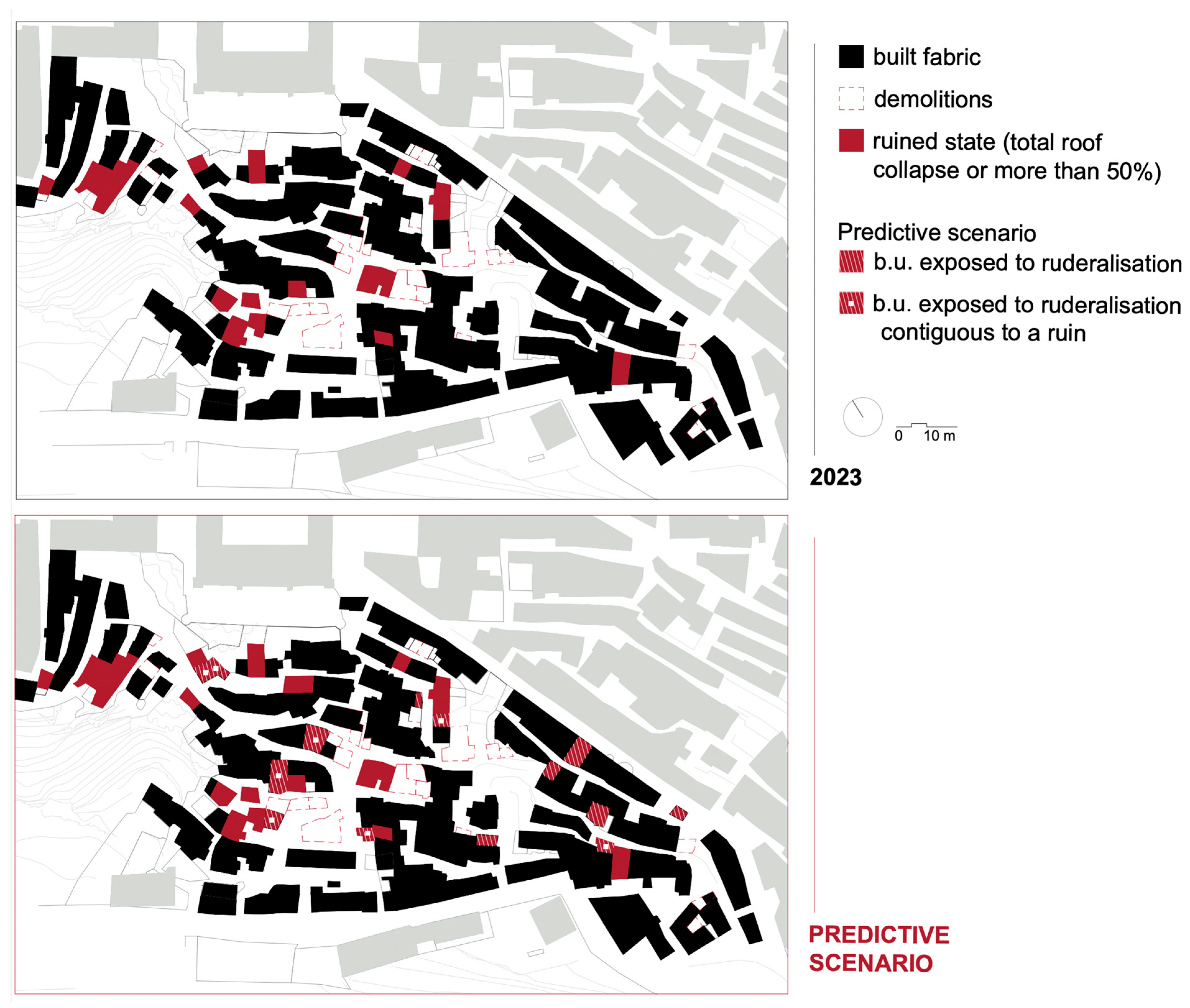
5.5. Predicted Ruination Risk Scenario
6. Discussion
6.1. Conceptualisation of the Phenomena Detected: Abandonment Pockets, Ruination Pockets, and the Contagion Effect
6.2. Considerations on the Results of Modelling the Phenomenon
6.3. Remarks
6.4. From the Perspective of the Local Policies
6.5. From the Perspective of Conservation of the Built Heritage
7. Conclusions
Author Contributions
Funding
Data Availability Statement
Conflicts of Interest
References
- Teti, V. Quel Che Resta: L’italia dei Paesi, Tra Abbandoni e Ritorn; Donzelli: Roma, Italy, 2017. [Google Scholar]
- ANCSA; CRESME. Centri Storici e Futuro del Paese. Indagine Nazionale Sulla Situazione dei Centri Storici; ANCSA: Roma, Italy, 2017; Available online: http://www.cresme.it/doc/rapporti/Centri-storici-e-futuro-del-Paese.pdf (accessed on 4 April 2022).
- CERTU. Centralité dans la ville en mutation. In Quelles Perspectives D’action Pour les Pouvoirs Publics? CERTU: Lione, France, 2003. [Google Scholar]
- Fiorani, D. Il futuro dei centri storici. In Digitalizzazione e Strategia Conservative; Quasar: Roma, Italy, 2019. [Google Scholar]
- Gizzi, F.T.; Bentivenga, M.; Lasaponara, R.; Danese, M.; Potenza, M.R.; Sileo, M.; Masini, N. Natural Hazards, Human Factors, and “Ghost Towns”: A Multi-Level Approach. Geoheritage 2019, 11, 1533–1565. [Google Scholar] [CrossRef]
- Pavan, C.; Pavan, N.; Semenzin, C. Osservare per governare un territorio. In Il Bel Paese; Un Progetto per 22.621 Centri Storici; Albrecht, B., Magrin, A., Eds.; Rubettino: Saveria Mannelli, Italy, 2017; pp. 118–133. [Google Scholar]
- Fiorani, D. Metodologie d’indagine sul problema dell’abbandono dei centri storici. Un’introduzione. ArchHistoR 2020, 13, 675–681. [Google Scholar]
- Trovato, M.R.; Nasca, L. An Axiology of Weak Areas: The Estimation of an Index of Abandonment for the Definition of a Cognitive Tool to Support the Enhancement of Inland Areas in Sicily. Land 2022, 11, 2268. [Google Scholar] [CrossRef]
- Iannotta, F. Ghost towns and housing discomfort: The landscapes of risk in Italy. UPLanD 2016, 4, 273–300. [Google Scholar]
- Pazzagli, R. Un Paese di Paesi. Luoghi e Voci dell’Italia Interna; ETS: Pisa, Italy, 2021. [Google Scholar]
- Bassanelli, M. Geografie dell’abbandono. La dismissione dei borghi in Italia. Master Degree Thesis, Politecnico di Milano, Milano, Italy, 2010. [Google Scholar]
- Coletta, T. I Centri Storici Minori Abbandonati della Campania; Conservazione, Recupero e Valorizzazione; Edizioni Scientifiche Italiane: Naples, Italy, 2014; ISBN 8849520611. [Google Scholar]
- Telford, L. English Nationalism and Its Ghost Towns; Routledge: Abingdon, UK, 2022; pp. 1–156. [Google Scholar] [CrossRef]
- Batty, M. Empty buildings, shrinking cities and ghost towns. Environ. Plan. B Plan. Des. 2016, 43, 3–6. [Google Scholar] [CrossRef]
- Rajan, G. Ghost Town, Ohio. Kenyon Rev. 2021, 43, 6. [Google Scholar]
- Varagnoli, C.; Serafini, L.; Verazzo, C. I luoghi dell’abbandono. I centri minori dell’Abruzzo e del Molise. ArcHistoR 2020, 13, 261–291. [Google Scholar]
- Giuffrida, S.; Trovato, M.R.; Circo, C.; Ventura, V.; Giuffrè, M.; Macca, V. Seismic Vulnerability and Old Towns. A Cost-Based Programming Model. Geosciences 2019, 9, 427. [Google Scholar] [CrossRef]
- Giuffrida, S.; Carocci, C.; Circo, C.; Giuffre, M.; Rosa Trovato, M.; Ventura, V. Axiological strategies in the old towns seismic vulnerability mitigation planning. Valori Valutazioni 2020, 25, 99–106. [Google Scholar]
- Nasca, L.; Giuffrida, S.; Trovato, M.R. Value and Quality in the Dialectics between Human and Urban Capital of the City Networks on the Land District Scale. Land 2021, 11, 34. [Google Scholar] [CrossRef]
- Giuffrida, S.; Gagliano, F.; Giannitrapani, E.; Marisca, C.; Napoli, G.; Trovato, M.R. Promoting Research and Landscape Experience in the Management of the Archaeological Networks. A Project-Valuation Experiment in Italy. Sustainability 2020, 12, 4022. [Google Scholar] [CrossRef]
- Giuffrida, S.; Ventura, V.; Nocera, F.; Trovato, M.R.; Gagliano, F. Technological, axiological and praxeological coordination in the energy-environmental equalization of the strategic old town renovation programs. In Values and Functions for Future Cities; Print ISBN: 978-3-Part of Green Energy and Technology; Mondini, G., Oppio, A., Stanghellini, S., Bottero, M., Abastante, F., Eds.; Springer Nature: Cham, Switzerland, 2020; pp. 425–446. [Google Scholar] [CrossRef]
- Caniggia, G.; Maffei, G.L. Lettura Dell’edilizia di Base; Marsilio: Venezia, Italy, 1995. [Google Scholar]
- Zampilli, M. Analisi dei processi formativi dei tessuti urbani: Note di metodo. Ric. Di Stor. Dell’arte 2014, 37, 23–34. [Google Scholar]
- Historic England. Understanding Place Historic Area Assessments. 2017. Available online: historicengland.org.uk/images-books/publications/understanding-place-historic-area-assessments/ (accessed on 2 April 2023).
- Giuffré, A.; Carocci, C.F. Codice di Pratica per la Sicurezza e la Conservazione dei Sassi di Matera; La Bautta: Matera, Italy, 1997. [Google Scholar]
- Ceradini, V. (Ed.) Area della Grecanica. In Codice di Pratica per la Sicurezza e la Conservazione degli Insediamenti Storici; Gangemi: Reggio Calabria, Italy, 2003. [Google Scholar]
- Carocci, C.F. Conoscere per Abitare: Un Seminario di Studio a Motta Camastra; Icosaedro: Siracusa, Italy, 2008. [Google Scholar]
- Vegas, F.; Mileto, C. Aprendiendo a Restaurar. Un Manual de Restauración de la Arquitectura Tradicional de la Comunitat Valenciana, 2nd ed.; Generalidad Valenciana: Valencia, Spain, 2017; ISBN 978-84-482-6178-8. [Google Scholar]
- Guidoboni, E.; Ferrari, G. The effects of earthquakes in historical cities: The peculiarity of the Italian case. Ann. Di Geofis. 2000, 43, 667–686. [Google Scholar] [CrossRef]
- Carocci, C.F. Conservazione del tessuto murario e mitigazione della vulnerabilità sismica. In troduzione allo studio degli edifici in aggregato. In Architettura Storica e Terremoti; Protocolli Operativi per la Conoscenza e la Tutela; Blasi, C., Ed.; Gangemi: Reggio Calabria, Italy, 2013; pp. 138–153. [Google Scholar]
- Carocci, C.; Vitale, M.R. Criteri, norme e linee guida per gli interventi nei Piani di Ricostruzione di Villa Sant’Angelo e Fossa (AQ). In Recupero, Valorizzazione, Manutenzione Nei Centri Storici; Castagneto, F., Fiore, V., Eds.; LetteraVentidue: Siracusa, Italy, 2013; pp. 118–121. [Google Scholar]
- Carocci, C.; Vitale, M.R. Restauro, ricerca, didattica. Una sperimentazione metodologica per l’intervento sui tessuti storici. In RICerca/REStauro; Fiorani, D., Ed.; Quasar: Roma, Italy, 2017; pp. 950–957. [Google Scholar]
- Ortiz, R.; Ortiz, P. How to evaluate and mitigate vulnerability of historical buildings. A Spanish project experience. Energ. Ambiente Innov. 2016, 4, 89–93. [Google Scholar] [CrossRef]
- Santos, C.; Ferreira, T.M.; Vicente, R.; Mendes da Silva, J.A.R. Building typologies identification to support risk mitigation at the urban scale—Case study of the old city centre of Seixal, Portugal. J. Cult. Herit. 2013, 14, 449–463. [Google Scholar] [CrossRef]
- Vicente, R.; Ferreira, T.M.; Raimuondo Mendes da Silva, J.A. Supporting urban regeneration and building refurbishment. Strategies for building appraisal and inspection of old building stock in city centres. J. Cult. Herit. 2015, 16, 1–14. [Google Scholar] [CrossRef]
- Ferreira, T. Seismic Vulnerability Assessment of Old Urban Centres—Case Study of the Old City Centre of Seixal, Portugal; Faculty of Engineering of the University of Porto: Porto, Portugal, 2010. [Google Scholar]
- Boukri, M.; Farsi, M.N.; Mebarki, A.; Belazougui, M.; Ait-Belkacem, M.; Yousfi, N.; Guessoum, N.; Benamar, D.A.; Naili, M.; Mezouar, N.; et al. Seismic vulnerability assessment at urban scale: Case of Algerian buildings. Int. J. Disaster Risk Reduct. 2018, 31, 555–575. [Google Scholar] [CrossRef]
- Sebastián Franco, S. Recuperando Ruesta. Plan de Actuación para la Recuperación de Ruesta. 2017. Available online: https://www.sergiosebastian.es/blog/2018/2/18/plan-de-actuacin-para-la-rehabilitacin-de-ruesta (accessed on 30 August 2023).
- Sportich du Réau de La Gaignonnière, A. A qui profitent les ruines? Conserver ou transformer: Le renversement des logiques dans le centre d’une petite ville. Rev. Mark. Territ. 2021, 6. Available online: http://publis-shs.univ-rouen.fr/rmt/index.php?id=544 (accessed on 18 September 2023).
- Repérant, D.; Trochet, J. Maisons Paysannes et Petit Patrimoine: La France Rurale; Editions du Chêne: Paris, France, 2006. [Google Scholar]
- Correia, M. (Ed.) Versus. Lessons from Vernacular Heritage; Actes Sud: Arles, France, 2014. [Google Scholar]
- Frey, P. Learning from Vernacular; Actes Sud: Arles, France, 2010. [Google Scholar]
- Oliver, P. Built to Meet Needs: Cultural Issues in Vernacular Architecture; Elsevier: Amsterdam, The Netherlands, 2006. [Google Scholar]
- Formez, P.A.; IFEL-ANCI. L’associazionismo Intercomunale Nelle Aree Interne; STR Press: Pomezia, Italy, 2019; Available online: http://focus.formez.it/sites/all/files/formez_azioni_40.pdf (accessed on 4 April 2022).
- Strategia Nazionale per le Aree Interne: Definizione, Obiettivi, Strumenti e Governance. Materiali Uval. Documenti 2014, 31. Available online: https://politichecoesione.governo.it/media/2289/numero-31_documenti_2014_aree_interne.pdf (accessed on 10 January 2020).
- Nucleo di Valutazione e Analisi per la Programmazione. Aggiornamento 2020 della Mappa delle Aree Interne. Nota Tecnica NUVAP. 2022. Available online: https://politichecoesione.governo.it (accessed on 10 September 2023).
- Istituto Nazionale Di Statistica. La Geografia delle Aree Interne nel 2020: Vasti Territori Tra Potenzialità e Debolezze. Available online: https://www.istat.it/it/archivio/273176 (accessed on 10 September 2023).
- Agenzia per la Coesione Territoriale. Strategia Nazionale Aree Interne (NSIA). Available online: https://www.agenziacoesione.gov.it/strategia-nazionale-aree-interne/ (accessed on 13 April 2023).
- Salerno, R.A. Landscapes of Abandonment; SUNY Press: Albany, NY, USA, 2012. [Google Scholar]
- Nicu, I.C. Cultural heritage assessment and vulnerability using Analytic Hierarchy Process and Geographic Information Systems (Valea Oii catchment, Northeastern Romania). An approach to historical maps. Int. J. Disaster Risk Reduct. 2016, 20, 103–111. [Google Scholar] [CrossRef]
- Aas, C.; Ladkin, A.; Fletcher, J. Stakeholder collaboration and heritage management. Ann. Tour. Res. 2005, 32, 28–48. [Google Scholar] [CrossRef]
- Ricoeur, P. Percorsi del Riconoscimento. Raffaello Cortina: Milano, Italy, 2005. [Google Scholar]
- Foresta, S. Valorizzare i centri storici per contrastare lo spopolamento. Urban. Inf. 2018, 273–274, 75–77. Available online: https://www.urbanisticainformazioni.it/valorizzare-i-centri-storici-per-contrastare-lo-spopolamento.html (accessed on 1 June 2023).
- Zanazzi, E.; Ferrari, L. Census of abandoned built heritage assets: The importance of defining shared methodologies and ontologies. Int. Arch. Photogramm. Remote Sens. Spat. Inf. Sci. ISPRS 2023, 48, 1665–1670. [Google Scholar] [CrossRef]
- Gustafsson, C.; Ripp, M. A metamodel for heritage-based urban recovery. Built Herit. 2020, 6, 29. [Google Scholar] [CrossRef]
- Comitato Nazionale Aree Interne. Rapporto di Istruttoria per la Selezione delle Aree Interne Regione Sicilia. 2022. Available online: https://politichecoesione.governo.it/media/3089/rapporto-istruttoria_regione-sicilia.pdf (accessed on 4 September 2023).
- ISTAT. Popolazione e Famiglie. 2022. Available online: https://www.istat.it/it/popolazione-e-famiglie?dati (accessed on 10 April 2023).
- Vitale, M.R.; Sanzaro, D.; Circo, C. La marginalizzazione dei centri storici in Sicilia. Fenomenologie, esperienze e strumenti di intervento. In La Città Palinsesto; Tracce, Sguardi e Narrazioni Sulla Complessità dei Contesti Urbani Storici; Pascariello, M.I., Veropalumbo, A., Eds.; Federico II University Press: Napoli, Italy, 2020; Volume 2, pp. 496–504. [Google Scholar]
- ISTAT. Basi Territoriali e Variabili Censuarie. Available online: https://www.istat.it/it/archivio/104317 (accessed on 19 October 2023).
- Patti, D. La facies rupestre nella Sicilia centrale: Aspetti metodologici e prospettive di ricerca. Mediaev. Sophia 2013, 13, 218–240. [Google Scholar]
- Vitale, M.R.; Circo, C.; Sanzaro, D.; Sebastiàn Franco, S.; Cacciatore, I.; Massimino, M. Perspectives for the small historical centres at risk of abandonment. A pilot project for the Granfonte district in Leonforte (Italy). In Vernacular Heritage: Culture, People and Sustainability; Mileto, C., Vegas, F., Cristini, V., Garcia-Soriano, L., Eds.; Universitat Politècnica de València: Valencia, Spain, 2022; pp. 937–944. [Google Scholar]
- Carocci, C.F.; Macca, V. Masons, nobles and viceroys. Building techniques in ancien régime Sicily. The Granfonte district in Leonforte. In Proceedings of the Tenth Annual Conference of the Construction History Society, Queens’ College, Cambridge, UK, 12–13 April 2023. [Google Scholar]
- Circo, C.; Cacciatore, I.; Massimino, M.; Sanzaro, D. Urban ruins in inhabited historic settlements. A preliminary study for safety improvement of the public spaces of the Granfonte district in Leonforte (Sicily). In Proceedings of the 13th International Conference of Structural Analisis of Historical Construction (SACH), Kyoto, Japan, 12–14 September 2023. [Google Scholar]
- Gangemi, G.; La Franca, R. Centri Storici di Sicilia; Vittorietti: Palermo, Italy, 1979. [Google Scholar]
- Mazzola, G. Notizie Storiche Sulla Vetusta Tavaca e Sulla Moderna Leonforte; Tipografia Editrice del Lavoro: Nicosia, Cyprus, 1924. [Google Scholar]
- Nigrelli, G.; Brivatura, A. C’era una Volta un Quartiere; Lancillotto e Ginevra: Troina, Italy, 2001. [Google Scholar]
- Vitale, M.R.; Versaci, A. Un destino di marginalizzazione. Il ruolo delle politiche urbane nell’abbandono del centro storico di Leonforte. ArchHistoR 2020, 13, 1948–1969. [Google Scholar]
- Nigrelli, G. Photographic archive, private collection, Leonforte (reserved access).
- Catasto Fabbricati 1878. Archivio di Stato di Enna. Fondo 70. Catasto (1840 ca.-1971). Reserved Access. Available online: https://archiviodistatoenna.cultura.gov.it/patrimonio-documentario/archivi-di-enti (accessed on 15 September 2020).
- Revenue Agency. Cadastral Map Leonforte. 2004. Available online: https://geoportale.cartografia.agenziaentrate.gov.it/age-inspire/srv/ita/catalog.search#/home?pg=homegeopoimap (accessed on 15 September 2020).
- Sicily Region, Regional Technical Map. Available online: https://www.sitr.regione.sicilia.it/cartografia/carta-tecnica-regionale/ (accessed on 30 August 2023).
- Revenue Agency. Cadastral Documents of Leonforte Parcel Units. Available online: https://www.agenziaentrate.gov.it/portale/visura-catastale1 (accessed on 15 September 2020).
- Technician Office of Leonforte Municipality, Building use Census, June–December 2009, Leonforte, 2010 (reserved access).
- Nuvolati, G. (Ed.) . Enciclopedia Sociologica dei Luoghi; Ledizioni: Milano, Italy, 2021. [Google Scholar]
- Google Earth. Available online: https://www.google.it/earth/ (accessed on 19 September 2023).
- Cacciatore, I.; Massimino, M. Prospettive Per Gli Insediamenti Parzialmente Abbandonati. Il Quartiere Granfonte a Leonforte (EN). Master’s Thesis, University of Catania, Catania, Italy, 2020. [Google Scholar]
- Laneri, G. l Territorio dello Sguardo. Un. Masterplan Strategico per il Restauro del Paesaggio a Sud di Leonforte. Master’s Thesis, University of Catania, Catania, Italy, 2021. [Google Scholar]
- Quagliarini, E.; Lucesoli, M.; Bernardini, G. Rapid tools for assessing building heritage’s seismic vulnerability: A preliminary reliability analysis. J. Cult. Herit. 2019, 39, 130–139. [Google Scholar] [CrossRef]
- Fais, S.; Casula, G.; Cuccuru, F.; Ligas, P.; Bianchi, M.G. An innovative methodology for the non-destructive diagnosis of architectural elements of ancient historical buildings. Sci. Rep. 2018, 8, e4334. [Google Scholar] [CrossRef] [PubMed]
- Carta del Rischio. Available online: http://www.cartadelrischio.beniculturali.it (accessed on 19 September 2023).
- Damas Mollá, L.; Sagarna, M.; Ane Zabaleta, A.; Aranburu, A.; Antiguedad, I.; Uriarte, J.A. Methodology for assessing the vulnerability of built cultural heritage. Sci. Total Environ. 2022, 845, 157314. [Google Scholar] [CrossRef]
- Ortiz, R.; Ortiz, P. Vulnerability index: A new approach for preventive conservation of monuments. Int. J. Archit. Herit. 2016, 10, 1078–1100. [Google Scholar] [CrossRef]
- Bachis, F.; Cois, E.; Giannattasio, C.; Pinna, A.; Pintus, V. Silenzi apparenti. Abbandono e spopolamento dei centri urbani in Sardegna tra passato e futuro. ArcHistoR 2020, 13, 683–770. [Google Scholar]
- East, M. Integrated Approaches and Interventions for the Regeneration of Abandoned Towns in Southern Italy. In From Conflict to Inclusion in Housing: Interaction of Communities, Residents and Activists; Cairns, G., Artopoulos, G., Day, K., Eds.; UCL Press: London, UK, 2017; pp. 87–102. [Google Scholar] [CrossRef]
- Verwest, F. Demographic Decline and Local Government Strategies: A Study of Policy Change in the Netherlands; Eburon: Delft, The Netherlands, 2011. [Google Scholar]
- Della Spina, L. Cultural Heritage: A Hybrid Framework for Ranking Adaptive Reuse Strategies. Buildings 2021, 11, 132. [Google Scholar] [CrossRef]
- Tocci, W. Una legge semplice per una buona urbanistica. In Proceedings of the Il Diritto Alla Città Storica, Rome, Italy, 12 November 2018. [Google Scholar]
- Hartt, M.D. How cities shrink: Complex pathways to population decline. Cities 2018, 75, 38–49. [Google Scholar] [CrossRef]
- EUROSTAT. Data. Available online: https://ec.europa.eu/eurostat (accessed on 15 April 2023).
- ISTAT. Anziani. Available online: https://www.istat.it/it/archivio/anziani (accessed on 15 April 2022).
- ISTAT. La Demografia dell’Europa. Available online: https://www.istat.it/demografiadelleuropa/img/pdf/Demograhy-InteractivePublication-2021_it.pdf?lang=en (accessed on 10 April 2023).
- ISTAT. Bilancio Demografico Nazionale. Available online: https://www.istat.it/it/archivio/245466 (accessed on 10 April 2023).
- European Commission. A Long-Term Vision for the EU’s Rural Areas. Building the Future of Rural Areas Together. 2019. Available online: https//ec.europa.eu/info/strategy/priorities-2019-2024/new-push-european-democracy/long-term-vision-rural-areas_en (accessed on 3 April 2023).
- European Union. Policy Brief. Shrinking Rural Regions in Europe towards Smart and Innovative Approaches to Regional Development Challenges in Depopulating Rural Regions. 2017. Available online: https://www.espon.eu/sites/default/files/attachments/ESPON%20Policy%20Brief%20on%20Shrinking%20Rural%20Regions.pdf (accessed on 10 April 2023).
- Liu, W.; Dunford, M.; Song, Z.; Chen, M. Urban–rural integration drives regional economic growth in Chongqing, Western China. Area Dev. Policy 2016, 1, 132–154. [Google Scholar] [CrossRef]
- Galadini, F. Ruins and Remains as a Background: Natural Catastrophes, Abandonment of Medieval Villages, and the Perspective of Civilization during the 20th Century in the Central Apennines (Abruzzi Region, Central Italy). Sustainability 2022, 14, 9517. [Google Scholar] [CrossRef]
- Pirlone, F. I Borghi Antichi Abbandonati, Patrimoni da Riscoprire e Mettere in Sicurezza; FrancoAngeli: Milano, Italy, 2016. [Google Scholar]
- Versaci, A.; Cardaci, A. The difficult relationship between ruins and modernity: The case study of the Mother Church reconstruction in Salemi (Italy). In Proceedings of the First International Conference on Architecture and Urban Design, Tirana, Albania, 9–21 April 2012. [Google Scholar]
- Biennal Internacional de Paisatge de Barcelona, Rehabilitación Integral del Barrio Medieval de Bocairent. Available online: https://www.arquitectes.cat/iframes/paisatge/fitxa/9857 (accessed on 10 September 2023).
- Sebastiàn Franco, S. Ruesta: Una bella rovina. ArcHistor 2020, 13, 818–845. [Google Scholar] [CrossRef]
- DeSilvey, C.; Fredheimi, H.; Blundelli, A.; Harrisonii, R. Identifying Opportunities for Integrated Adaptive Management of Heritage Change and Transformation in England: A Review of Relevant Policy and Current Practice; Research Report n. 18/2022; Historic England: London, UK; ISSN 2059-4453.
- Besse, J.M. Habiter: Un Monde à Mon Image; Flammarion: Paris, France, 2013. [Google Scholar]


| BU Identification | Id | ||
|---|---|---|---|
| BU Characteristics | |||
| Level 1 | Level 2 | Score | |
| Ruination | (0–6) | ||
| X1 | Typological characteristics | Period of construction | (1–9) |
| X2 | B.U. layout related to the aggregate | (1–4) | |
| X3 | B.U. layout related to the proportions of the slope | (1–3) | |
| X4 | B.U. position related to the slope | (1–2) | |
| X5 | Plan changes | (1–4) | |
| X6 | Elevation changes | (1–5) | |
| X7 | Building use | Use | (1–4) |
| X8 | Accessibility | Accessibility | (1–4) |
| X9 | Elevation walls | No. of shared walls with contiguous B.U. | No. |
| X10 | No. of floors contiguous to ruins | No. | |
| X11 | Level of contiguity to ruins | (1–4) | |
| X12 | Surface degradation | (1–4) | |
| X13 | Masonry slackening | (1–4) | |
| X14 | Cracks | (1–4) | |
| X15 | Out of plumb | (1–4) | |
| X16 | Expelled wall surface (cornerstones, wall covers) | (1–4) | |
| X17 | Material disintegration | (1–4) | |
| X18 | Walls collapse | (1–4) | |
| X19 | Floors | Floor collapse | (1–5) |
| X20 | Roofs | Breaking of parts/water infiltrations | (1–4) |
| X21 | Roof collapse | (1–6) | |
| X22 | Openings | Reduced lintel | (1–2) |
| X23 | Wooden lintel efficacy | (1–2) | |
| X24 | Protruding volumes/elements | Gutter collapse | (1–5) |
| Model Summary | ||||
|---|---|---|---|---|
| Model | R | Estimation Std. Error | ||
| 1 | 0.887 | 0.786 | 0.783 | 0.70808 |
| ANOVA | ||||||
|---|---|---|---|---|---|---|
| Model | Sum of Squares | gl | Quadratic Average | F | Sign. | |
| 1 | Regression | 531.102 | 5 | 106.22 | 211.855 | 0.000 |
| Residual | 144.398 | 288 | 0.501 | |||
| Total | 675.5 | 293 | ||||
| Coefficients | ||||||
|---|---|---|---|---|---|---|
| Model | Non-Standardised Coefficients | Standardised Coefficients | t | Sign. | ||
| Beta | Standard Error | Beta | ||||
| 1 | (Constant) | 0.727 | 0.217 | 3.344 | 0.001 | |
| X18 | 0.599 | 0.078 | 0.376 | 7.716 | 0.000 | |
| X21 | 0.185 | 0.041 | 0.2 | 4.511 | 0.000 | |
| X15 | 0.388 | 0.068 | 0.263 | 5.715 | 0.000 | |
| X24 | 0.125 | 0.037 | 0.143 | 3.356 | 0.001 | |
| X23 | 0.103 | 0.048 | 0.059 | 2.143 | 0.033 | |
| Coefficients | ||||||
|---|---|---|---|---|---|---|
| Model | Correlations | Collinearity Statistics | ||||
| Zero Order | Partial | Part | Tolerance | VIF | ||
| 1 | (Constant) | |||||
| X18 | 0.829 | 0.414 | 0.21 | 0.313 | 3.194 | |
| X21 | 0.756 | 0.257 | 0.123 | 0.378 | 2.648 | |
| X15 | 0.792 | 0.319 | 0.156 | 0.351 | 2.849 | |
| X24 | 0.725 | 0.194 | 0.091 | 0.408 | 2.451 | |
| X23 | 0.194 | 0.125 | 0.058 | 0.972 | 1.029 | |
| Model Summary | ||||
|---|---|---|---|---|
| Model | Modification Statistics | |||
| gl1 | gl2 | Sign. Modification F | Durbin–Watson | |
| 5 | 1 | 288 | 0.033 | 1.908 |
Disclaimer/Publisher’s Note: The statements, opinions and data contained in all publications are solely those of the individual author(s) and contributor(s) and not of MDPI and/or the editor(s). MDPI and/or the editor(s) disclaim responsibility for any injury to people or property resulting from any ideas, methods, instructions or products referred to in the content. |
© 2023 by the authors. Licensee MDPI, Basel, Switzerland. This article is an open access article distributed under the terms and conditions of the Creative Commons Attribution (CC BY) license (https://creativecommons.org/licenses/by/4.0/).
Share and Cite
Sanzaro, D.; Trovato, M.R.; Circo, C. An Interpretive Ruination Model of the Built Heritage in Inner Areas: The Case Study of the Neighbourhood Granfonte in Leonforte. Heritage 2023, 6, 6965-6992. https://doi.org/10.3390/heritage6110364
Sanzaro D, Trovato MR, Circo C. An Interpretive Ruination Model of the Built Heritage in Inner Areas: The Case Study of the Neighbourhood Granfonte in Leonforte. Heritage. 2023; 6(11):6965-6992. https://doi.org/10.3390/heritage6110364
Chicago/Turabian StyleSanzaro, Deborah, Maria Rosa Trovato, and Chiara Circo. 2023. "An Interpretive Ruination Model of the Built Heritage in Inner Areas: The Case Study of the Neighbourhood Granfonte in Leonforte" Heritage 6, no. 11: 6965-6992. https://doi.org/10.3390/heritage6110364
APA StyleSanzaro, D., Trovato, M. R., & Circo, C. (2023). An Interpretive Ruination Model of the Built Heritage in Inner Areas: The Case Study of the Neighbourhood Granfonte in Leonforte. Heritage, 6(11), 6965-6992. https://doi.org/10.3390/heritage6110364