Article

Evaluating the Archaeological Efficacy of Bathymetric LiDAR across Oceanographic Contexts: A Case Study from Apalachee Bay, Florida

by
Jessica W. Cook Hale
1,2,*,†,
Dylan S. Davis
3,4,*,† and
Matthew C. Sanger
5
1
Department of Geology, University of Georgia, Athens, GA 30602, USA
2
Aucilla Research Institute, Monticello, FL 32344, USA
3
Columbia Climate School, Columbia University, New York, NY 10025, USA
4
Division of Biology & Paleoenvironment, Lamont-Doherty Earth Observatory, Palisades, NY 10964, USA
5
National Museum of the American Indian, Smithsonian Institution, Washington, DC 20560, USA
*
Authors to whom correspondence should be addressed.
These authors contributed equally to this work.
Heritage 2023, 6(2), 928-945; https://doi.org/10.3390/heritage6020051
Submission received: 29 December 2022 / Revised: 18 January 2023 / Accepted: 19 January 2023 / Published: 21 January 2023
(This article belongs to the Special Issue Geophysical Surveys for Heritage and Archaeology)

Abstract

:
This study presents preliminary results from recent bathymetric LiDAR-guided surveys of submerged archaeological landscapes in the Apalachee Bay off the coast of Florida. We show how bathymetric LiDAR can re-identify previously recorded archaeological sites and identify new cultural deposits at shallow depths and help aid SCUBA surveys of submerged environments. While most prior archaeological applications of bathymetric LiDAR have focused on shipwrecks and historic era sites, our case study demonstrates that bathymetric LiDAR is capable of detecting Holocene and Pleistocene era archaeological sites as well. Detecting and eventually characterizing these ancient deposits will greatly expand our understanding of settlement trends when sea levels were lower and may provide insights into how some of the earliest coastal populations adapted to this novel and changing environment. Our SCUBA surveys also elucidate the impact of local environmental conditions of the applicability of deploying bathymetric LiDAR; specifically, eel grass cover does not hinder LiDAR capabilities, while high rates of sedimentation greatly reduce success in identifying archaeological deposits. Overall, our results show promise in the future of applying remote sensing to study shallow submerged archaeological landscapes, which can help improve our understanding of human–environment dynamics prior to and during periods of sea level change.

1. Introduction

Sea levels have shifted many times over the course of human history, leaving evidence for significant events drowned on continental shelves across the world [1,2,3]. Rising seas have always forced coastal inhabitants to relocate, and as the modern climate crisis accelerates, climate refugees are becoming increasingly prevalent [4,5]. It is critical to emphasize the cyclical nature of marine transgressions caused by collapsing ice sheets; these events have occurred throughout human history, followed by coastal peoples adapting as their homes drowned beneath those rising waves [6,7,8,9]. As such, it is important that researchers study these submerged landscapes to understand past human–coastal ecosystem relationships.
While great strides have been made by researchers around the globe focused on submerged cultural heritage, traditional means of surveying ocean floors are exceedingly expensive, relying on ship-based sonar and radar sensors and underwater submersible vehicles [10,11,12,13]. However, advances in aerial laser scanning (ALS) technology have developed bathymetric LiDAR which shows promise for archaeological investigations of shallow water environments (<40 m). To date, almost all such archaeological bathymetric LiDAR studies have focused on shipwrecks, with few designed to record earlier cultural deposits [14,15].
Here, we focus on a case study from Apalachee Bay, Florida, U.S.A., where a bathymetric LiDAR survey was undertaken to generate high resolution data for primarily archaeological and cultural heritage management purposes (Figure 1). Our case study presents two different zones within Apalachee Bay, which each experience distinct sediment regimes. As such, this study presents an evaluation of bathymetric LiDAR’s utility for archaeological prospection efforts across different marine conditions. While the case study shows great promise for archaeological prospection efforts of shallow water environments, there are limitations in areas with high rates of sedimentation. We discuss how bathymetric LiDAR can successfully identify submerged, formerly terrestrial archaeological sites dating to before the establishment of modern sea levels, as well as the challenges in the acquisition and analysis of bathymetric LiDAR created by different environmental settings. We provide a test of the use of bathymetric LiDAR by first comparing results with the distribution of known archaeological sites in the study area, with which we then follow up through targeted dives on anomalies defined within the LiDAR datasets. Finally, we consider the role that bathymetric LiDAR datasets can play in the future of contract archaeology and policy related to cultural heritage management.

1.1. Background on Bathymetric LiDAR in Archaeological and Cultural Heritage Research

Bathymetric data collection primarily uses active remote sensing instruments, such as side-scan sonar, radar, etc. Less frequently, researchers have applied bathymetric (or green) LiDAR sensors, which can penetrate water columns to depths of up to 30–40 m, depending upon water conditions [16]. Traditional (near-infrared) LiDAR sensors usually record light in wavelengths of 1064–1550 nm, which can pierce vegetative canopies, but not water [17]. Within heritage and archaeological research, terrestrial LiDAR has been widely applied with great success [18]. Bathymetric (green) LiDAR, in contrast, records wavelengths of ~532 nm, which can record topography below shallow water surfaces [17].
Part of the reason for the slow uptick in bathymetric LiDAR for cultural heritage and archaeological purposes has been the historically low data quality and resulting spatial resolution of these datasets [15]. However, improvements in green LiDAR technology have increased point density and subsequent spatial resolution of LiDAR-derived products (such as digital elevation models). Archaeological exploration has followed [14,15,19,20,21,22], but most applications have focused either in tropical waters with exceptional water clarity and/or on historic era sites such as shipwrecks, which are prominent and stand distinct from surrounding sea floors. While there have been some increases in the use of bathymetric LiDAR for underwater survey projects, these data are usually not used alone, but merged with other bathymetric datasets acquired from sonar systems [23,24].
Given the limited set of applications for cultural heritage research, there are many elements that are currently under-studied in terms of bathymetric LiDAR’s utility in different submerged environments. Apart from the obvious constraints surrounding water clarity and turbidity, what are the effects of underwater vegetation (e.g., seagrass beds), sediment inflow, and currents on the visibility of archaeological deposits, specifically, in bathymetric LiDAR? We know from other studies that sedimentation rates can change sea–floor morphology, which subsequently cause errors in bathymetric mapping by instruments such as LiDAR [25]. Such changes in sedimentation rate also influence the appearance and overall preservation of historic sites such as shipwrecks [26], and without multitemporal capabilities, bathymetric data may miss sites that are buried by compacted sediments or eroded due to a lack of sediment inflow [27]. Shipwrecks are far more pronounced than other kinds of archaeological deposits, however, and given these dynamic oceanic processes, another question to be asked is whether bathymetric LiDAR is capable of identifying deposits from the Pleistocene and Holocene epochs. In this paper, we seek to address some of these questions and demonstrate the overall utility of bathymetric LiDAR products for recording submerged Holocene-era archaeological sites in North America.

1.2. Apalachee Bay: Geological and Archaeological Background

1.2.1. Bedrock Geology

Underlying geological factors dramatically impact the effectiveness and applicability of different remote sensing technologies, including the use of bathymetric LiDAR. Apalachee Bay is defined by its karst terrain as soluble rocks, including limestone, have eroded over millennia, resulting in an uneven ocean floor marked by numerous sinkholes and caves. The bedrock formations are primarily of Tertiary age, having been deposited in shallow marine contexts during the period when the Suwannee Straits were an open seaway connecting the Gulf of Mexico to the Atlantic Ocean; these carbonate formations were subsequently buried by siliciclastic sediments derived from the Appalachians to the north [28]. The limestone formation on the eastern side of the bay is composed primarily of Oligocene Suwannee limestone but grades into the younger Miocene St. Marks formation along the northern and western side of the bay.
The Suwannee limestone varies in hardness, from poorly indurated grainstone to well-indurated packstone. Some portions of this formation are dolomitized, a process that occurs when the calcium in a limestone is partially to completely replaced by magnesium. This process typically occurs due to contact with freshwater carrying increased levels of magnesium, usually in the form groundwater from a regional aquifer. These dolomitized carbonate formations are often moderately to well indurated.
Overlying sediments are composed of Pleistocene to Holocene materials, primarily clastic sands, gravels, and clay [29]. These sediments differ in thickness depending on proximity to the coastline; along the coast, they are less than 30 m thick, with an extremely low gradient, while farther to the north, in an area known as the Cody Escarpment, both depth and gradient increase. Sinkholes, caves, and other aspects of karst terrains are also more prevalent in this northern section due to multiple episodes of marine transgression/regression along with influences from groundwater dissolution of the carbonate bedrock [29].

1.2.2. Hydrogeological Conditions and Regional Fluvial and Coastal Geomorphology

The topography of the seabed in the Apalachee Bay is directly impacted by underlying hydrological and fluvial factors. These factors control how much sediment is brought to the bay, and deposited offshore, by the various river systems in the region. These, in turn, are influenced by groundwater and other hydrogeological factors.
Groundwater in this region is largely contained within a large regional aquifer, known as the Floridan Aquifer. The Floridan Aquifer is unconfined in the region around Apalachee Bay, with upwelling springs throughout the region where the aquifer intersects with the surface. These springs are primary sources for multiple fluvial systems that arise on the coastal plain. Throughout the region, these springs connect to subterranean cavern systems flooded with slightly acidic groundwater that can dissolve limestone bedrock over time. This can lead to collapse of overlying limestone bedrock over time, creating surficial fluvial channels. Thus, regional fluvial systems tend to be defined by these collapse channels instead of meandering within floodplains infilled with alluvial sediments.
There are several significant rivers that feed into Apalachee Bay: The Appalachicola, the St. Marks/Wakulla, the Aucilla, and the Econfina River. Of these rivers, only the Appalachicola is sourced to a region outside the coastal plain. Instead of originating on the coastal plain from waters fed by the Floridan Aquifer, the Appalachicola originates in the Blue Ridge Mountains. On its way to the Gulf, it picks up significant sediment load, some of which is sourced as far away as the southern Appalachian Mountains. The other rivers all originate within the nearby Coastal Plain, however, and are composed of intermittent channels that flow continuously only when they are within a few miles of the coastline. These fluvial channels are often controlled entirely by collapse features and carry minimal sediment loads to the northern and eastern portions of the bay [28,30,31].
As the rivers enter the Bay, their past courses are marked by the presence of paleochannels. Water depths are extremely shallow outside of these paleochannel features, which are relatively easy to detect given the very thin sediment cover over the bedrock. Eel grass beds dot the areas outside of the paleochannels. These beds make archaeological materials difficult to detect during diver survey while also providing habitat for a diverse suite of marine fauna, including scallops, sea turtles, and blue crabs [32]. Researchers have investigated the Aucilla paleochannel using marine geophysical methods, but this type of survey has not been conducted for any of the other paleochannel systems [33,34,35]. The bathymetric LiDAR datasets discussed in this study represent the first studies designed to delineate this submerged portion of the continental shelf since the geophysical studies carried out by Faught and colleagues in the 1990s and early 2000s and the first to investigate the other paleochannels.

1.2.3. Paleohydrology and the Archaeology of Apalachee Bay

To date, much of the archaeological work conducted in the Apalachee Bay has focused on the earliest known occupations in the region, typically dating to the late Pleistocene and early Holocene [34]. Table 1 summarizes chronozones as well as correlating cultural periods for this region. Research demonstrates that these earliest occupants took advantage of the karst-controlled rivers fed by the Floridan Aquifer. These were likely the best, if not the only, freshwater resources in the region, because they dropped along with relative sea levels during the last glacial period, leaving a series of sinkholes dotting the landscape instead of flowing channels [35,36]. These sinkholes attracted fauna in search of food and water, and human groups followed them to these locations [37,38]. Abundant chert outcrops associated with sinkholes, caves, and other karst landscape features also provided access to stone tool source materials and were a draw for many human groups [36,39,40,41]. While these archaeological trends were first observed at onshore sites, they also extend into the offshore zone [34,35], which is unsurprising given that the West Florida Shelf was not submerged until the end of the middle Holocene epoch, well after humans entered the region.
Using these occupational trends, archaeologists created and applied a highly successful prediction model in the 1980s and 1990s that identified more than two dozen offshore sites or activity areas [35,42]. Sites ranged in age from terminal Pleistocene to middle Holocene and encompassed site types from quarry sites to habitation sites to shell midden sites [35]. Work is ongoing, with a strong focus on site formation processes alongside human cultural adaptations to climate change, among other topics [43,44,45,46].

1.3. Early Coastal Sites in the Region

Despite decades of research, little is known about early coastal peoples living in the region. Most of the early sites close to the modern shoreline (both terrestrial and offshore) were inland landscapes when they were occupied in the terminal Pleistocene and early Holocene due to the extremely wide continental shelf along the eastern Gulf of Mexico. Evidence for coastal occupations older than the middle Holocene are submerged farther away from the modern shore [33,34,35,41,42]. One example, Ray Hole Springs, a site that dates to the terminal early or early middle Holocene, is more than 30 km from the modern coastline [42]. The nature of coastal occupations earlier than the beginning of the late Holocene is unclear in this region [47] and represents a significant data gap in the archaeological record [48].
Better understanding of coastal occupations prior to the onset of near-modern conditions at the onset of the late Holocene is critically important to archaeologists interested in how humans around the world adapted to the unique resources and challenges associated with this dynamic environment. Current research into coastal adaptation is hampered by an archaeological record truncated by past and present sea level rise that has inundated thousands of years of prior occupations. This truncation has long been recognized in the Southeast United States, where archaeologists are typically forced to rely solely on late Holocene-age deposits when attempting to recreate ancient coastal occupations. These deposits are notable in that in many parts of the Southeast United States, including along the coastline of the Gulf and within the St. John’s River valley, there is strong evidence that Native American peoples were living year-round in relatively large occupations, marked by the presence of large shell mounds [49,50,51]. Most early examples likely represent extraction sites for aquatic resources [52,53,54,55,56,57,58], but by the onset of the late Holocene, some of these sites clearly took on symbolic aspects [59]. Shell mounds are, thus, archaeologically visible by the end of the middle Holocene when relative sea levels approached the modern coastline, but they cannot be ruled out for earlier periods. Evidence for mound construction dating to earlier periods would be of great archaeological significance.
Prior research at the Econfina Channel site, a large shell midden site dating to the end of the middle Holocene and the beginning of the late Holocene and located approximately 3 nautical miles offshore of the eastern portion of Apalachee Bay, demonstrates that such earlier shell mounds are present in offshore environments. The site includes a human-made shell midden measuring at least 30 m across [43,45]. Sampling after two hurricane impacts (Hermine in 2016 and Irma in 2017) demonstrates that while the site may have deflated small amounts, it did not shift horizontally [46]. Other similar deposits at the nearby sites of Ontolo and J&J Hunt, located a few nautical miles to the north of Econfina Channel, suggest that pre–late Holocene shell middens have survived marine transgression and thousands of years’ worth of post-submergence disturbances and that a previously unrecognized archaeological record of early coastal occupations survives in the Apalachee Bay [35].

2. Materials and Methods

2.1. Bathymetric LiDAR

Between 2016 and 2022, bathymetric LiDAR surveys of the Apalachee Bay were commissioned by the Aucilla Research Institute. The areas encompassed three areas of archaeological interest: the Aucilla River paleochannel, the Econfina River paleochannel, and Ocholocknee Shoals (Figure 1). The Aucilla paleochannel was targeted because it encompasses multiple documented submerged terminal Pleistocene to middle Holocene sites [33,34,35,60]. The Econfina paleochannel was targeted because it also contains documented submerged, pre-contact archaeological sites and locales but no occupations older than middle Holocene [33,34,35,43,45,46]. Both paleochannel systems were chosen to operate both as controls (due to the presence of known archaeological sites) and high probability areas for additional archaeological prospection on the shallow continental shelf.
Ocholocknee Shoals was targeted because it is very poorly understood, with no formal survey having been conducted since the 19th century. Despite this data gap, this portion of Apalachee Bay is considered to have a potentially high probability of containing submerged pre-contact archaeological sites and locales due to its proximity to several putative paleochannel systems as well as a geomorphology suggestive of a drowned barrier island. Barrier islands have been highly favored landforms for settlement along the Southeast U.S. coastlines since the end of the middle Holocene, while paleochannels are routinely targeted for submerged pre-contact site testing [61,62].

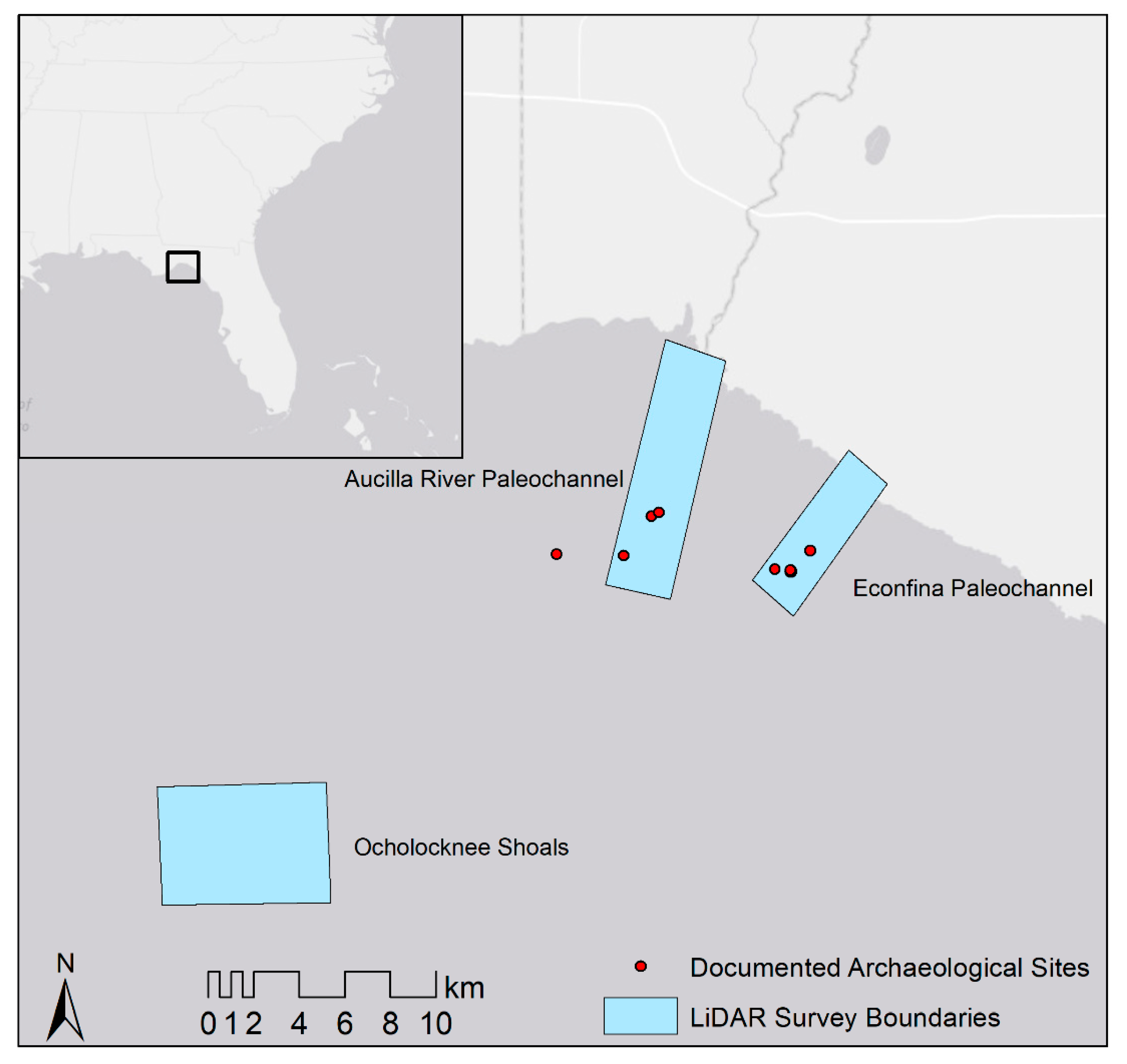
2.1.1. Aucilla and Econfina River Paleochannels

A total of 46.62 km2 were surveyed (30.82 km2 in Aucilla, 15.80 km2 in Econfina) using topobathymetric LiDAR by Dewberry Consultants LLC in 2016. Dewberry collected bathymetric LiDAR and delivered raw LAS data and a digital elevation model (DEM) at 0.3 m (1 ft) resolution with classified returns. LiDAR was collected according to ASPRS Accuracy Standards and contained a minimum point density of 2 points/m2, with a root mean square error (RMSE) of 10 cm in non-vegetated terrain, and a non-vegetated vertical accuracy (NVA) of 19.6 cm.

2.1.2. Ocholocknee Shoals

A total of 38.66 km2 of area was scanned using topobathymetric LiDAR by NV5 Geospatial in December 2022. LiDAR data were collected using a Riegl VQ-880-GII green laser system mounted in a Cessna Caravan. The LiDAR data were captured at an altitude of 400 m and attained a point density of ≥6 points/m2, with a root mean square error (RMSE) of 10 cm in non-vegetated terrain, and a non-vegetated vertical accuracy (NVA) of 19.6 cm. Processing of the bathymetric data was conducted by NV5 Geospatial using Riegl’s RiProcess software. The data points were classified by return value and then spatially corrected for refraction through the water column on the basis of the incidence angle of the laser. NV5 refracted the water column points using their LAS processing software, Las Monkey [63].

2.1.3. Visualizations

To enhance visualization of recorded LiDAR point data, we used DEMs provided by NV5 Geospatial and Dewberry Consultants LLC (for visual and computer-assisted analysis). Because of challenges associated with bathymetric LiDAR point returns, interpolation can create ambiguity because no-return points could signify a drop in depth that the laser cannot reach [63]. As such, we used DEM products that use triangulated surface interpolation (TIN) and control points in the classified LiDAR points to calculate bathymetry only for areas with good point density and data control. This process helped to alleviate artifacts in the data and ensure that null return areas that exceeded 9.3 m2 were recorded as data voids rather than interpolated into the DEM.

2.2. Distribution of Known Archaeological Sites

To create a control, we collated the location of all known archaeological sites from Ocholocknee Shoals and the Aucilla and Econfina Rivers. These sites include those previously defined using geophysical techniques as well as those further explored through diver surveys [33,34,35]. The sites include shell deposits, lithic scatters, possible submerged sinkhole sites, and potential rock quarries along paleochannels.

2.3. SCUBA Surveys and Environmental Analysis

To confirm the results from bathymetric analysis, particularly to test the analysis of Ocholocknee Shoals, diver surveys were carried out during three field campaigns during the summer of 2022. Two campaigns focused on Ocholocknee Shoals because it was the largest survey area that presented the greater logistical challenge, being farther offshore than the Econfina and Aucilla paleochannels. One campaign focused on the Econfina paleochannel because it contains known, now-submerged sites associated with middle to late Holocene coastal occupations. We chose these two areas because they represent completely different marine conditions. Ocholocknee Shoals has higher energy conditions, being farther offshore (~10 nautical miles) with increased levels of sedimentation due to its proximity to the Appalachicola River delta to its west, while Econfina lies much closer to shore (~3 nautical miles) and experiences much less sedimentation due to its proximity to the Econfina and Aucilla Rivers on the east side of the bay, which are entirely karst-controlled rivers. The Aucilla paleochannel was not tested using diver survey at this time due to time constraints on field operations.
Diver survey was carried out by selecting targets for investigation followed by visual survey. Divers were dropped on target coordinates and then carried out circle searches at increasing intervals (10 m, 20 m, etc.) from the drop point. Survey observations were conducted to determine water depths, sediment types, eel grass presence or absence, rock outcrop presence or absence, visual evidence for paleochannels, presence or absence of archaeological materials, and geologic conditions. Depth data were recorded by dive computer for each dive, and all other data were recorded using a combination of field notes, dive logs, and photography, where possible.
Samples of the following materials were collected: sediments, any archaeological materials, and geologic samples of rock outcrops. Photography and videography were carried out at the Econfina paleochannel targets, but water conditions were not suitable for this method at Ocholocknee Shoals. Simple sediment probing with a metal rod was carried out at Ocholocknee Shoals to determine approximate depth to bedrock, while hand fanning was carried out at the Econfina paleochannel targets to expose bedrock and shell materials, as needed.

3. Results

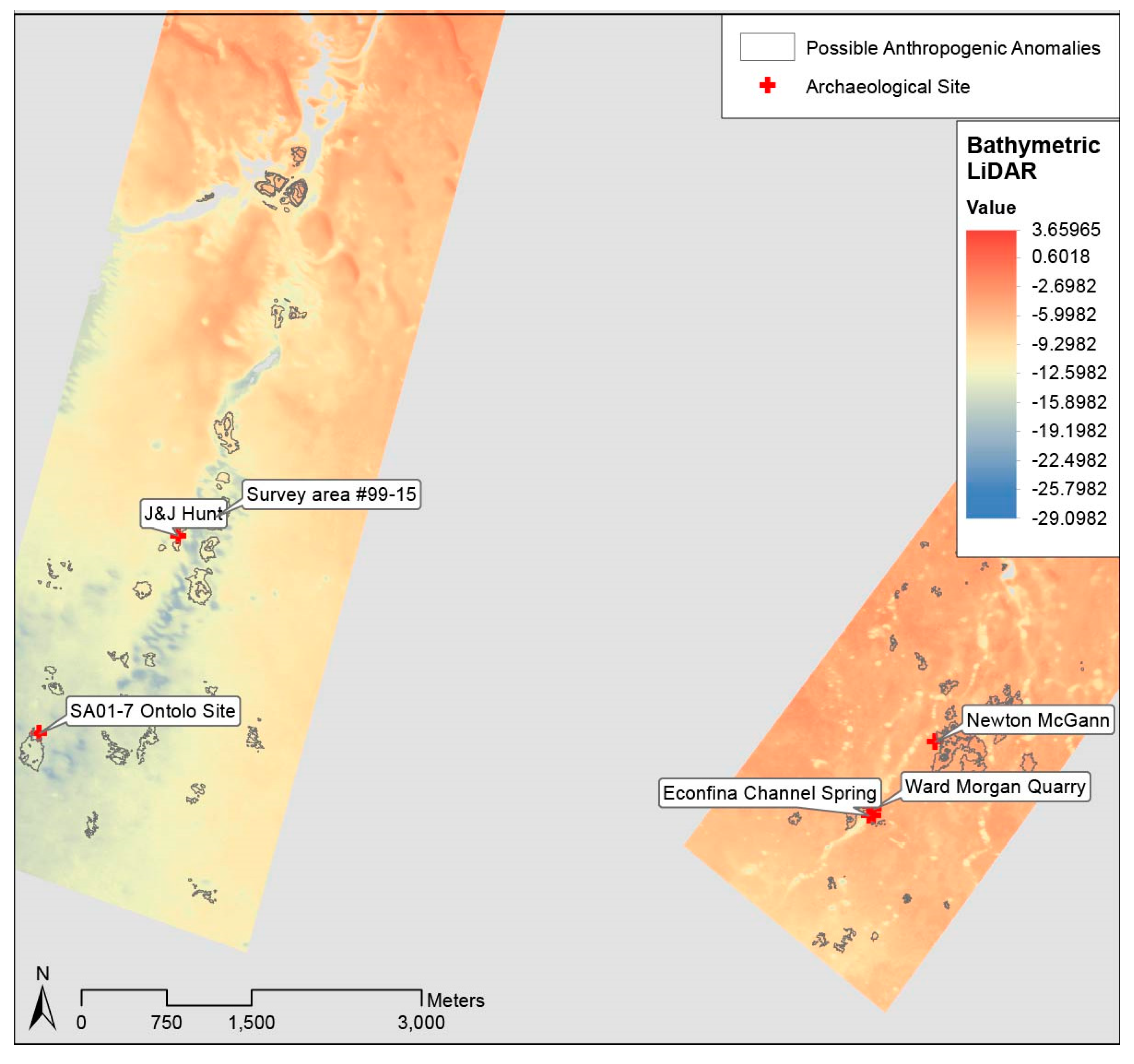
3.1. Bathymetric LiDAR Survey

Evaluation of the LiDAR data resulted in the identification of 30 locations of archaeological interest in Econfina, 31 locations in Aucilla, and 15 locations in Ocholocknee. Locations of archaeological interest were chosen on the basis of their overall size and morphology combined with their elevation profiles, which match expectations for other mound and midden sites in the region [64,65].
Next, we compared the locations of these anomalies with the distribution of archaeological sites that had already been recorded in prior surveys and found that two previously confirmed archaeological sites in Econfina were re-identified in the LiDAR data. Moreover, three sites previously recorded along the Aucilla (representing all of the previously recorded known sites that lie within the study boundaries along the Aucilla) were also identifiable. No prior archaeological surveys have been conducted within Ocholocknee Shoals, leaving this locale as a control for comparison using diver survey.

3.2. Diver Surveys

We conducted dives on 2 of the locations defined in Econfina River paleochannel over the course of 3 sea days and 10 of the locations defined in the Ocholocknee Shoals over the course of 10 sea days. Of these locations, we defined one new site in the Econfina and one possible site in Ocholocknee, which we detail below. Some locations outside of the target areas were also tested for geological observations and are included here to provide additional environmental context.

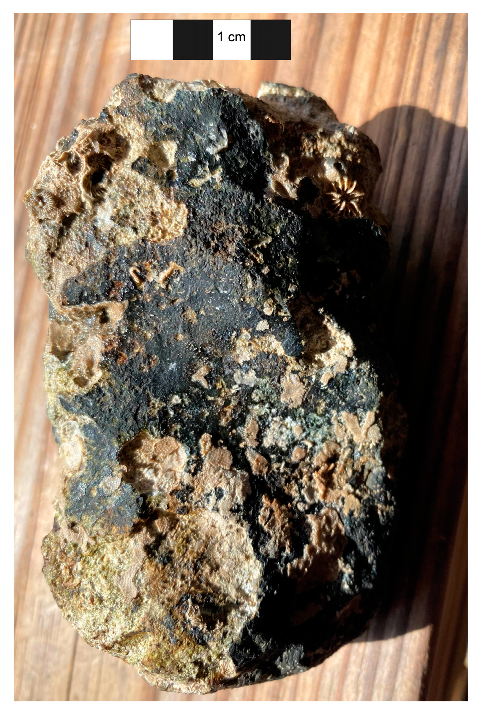
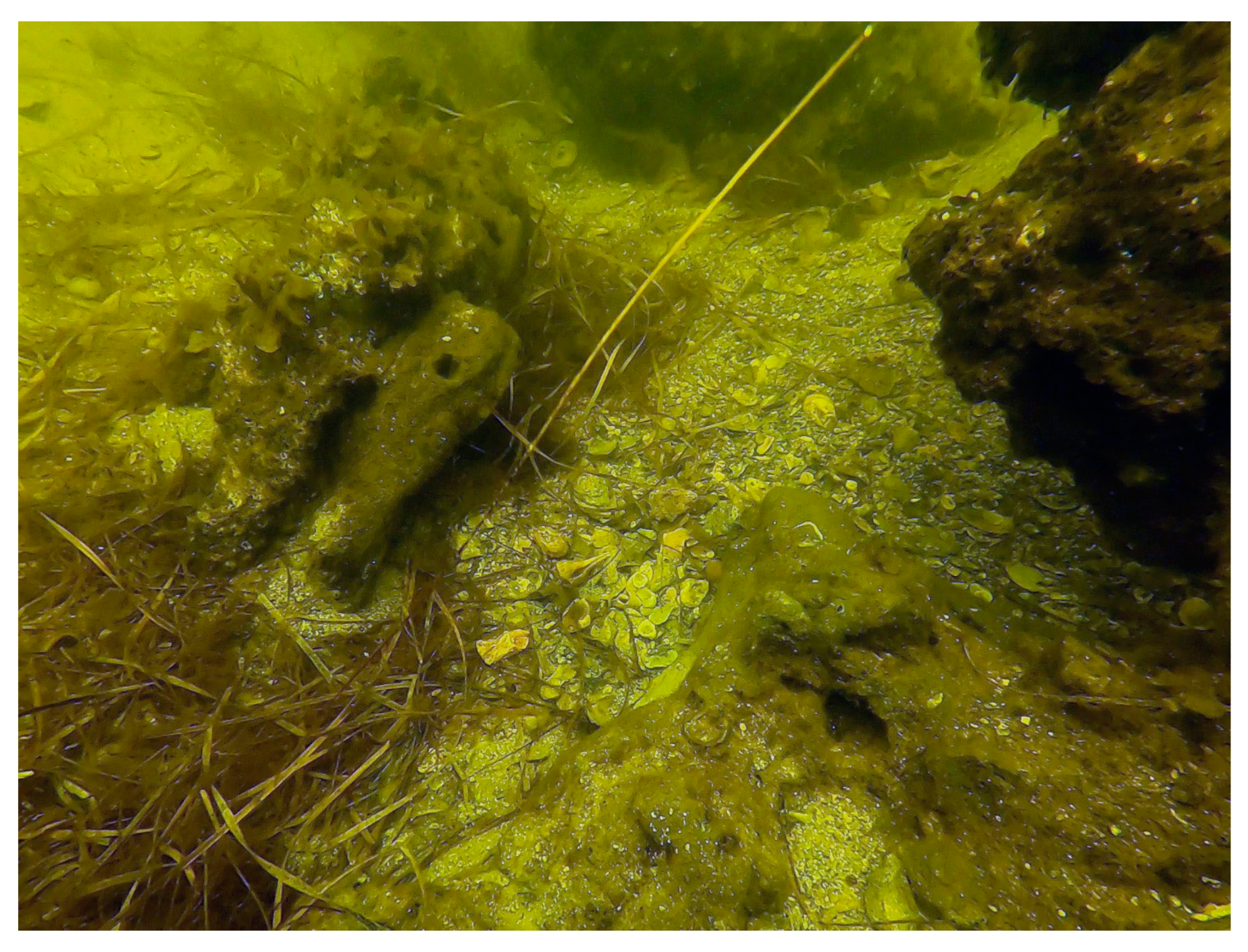
3.2.1. Ocholocknee Shoals

Figure 2 and Table 2 show locales visited during diver survey activities, which were carried out in May and June of 2022. Photography at each station was not possible due to comparatively poor visibility. Broadly, only one location tested at Ocholocknee Shoals (Station 9) demonstrated minimal sediment cover conditions such as those more often observed on the eastern side of Apalachee Bay, and this was the only location where we encountered potential evidence for human activities.
Coarse to very coarse sands and fine shelly gravels were observed at Station 9 along with intermittent carbonate and chert outcrops/hard bottom reef ledges; this is consistent with higher energy marine contexts as well as paleochannel features. No bedforms were apparent during diver survey, but review of the western portion of Ocholocknee Shoals indicates that bathymetry may be consistent with an ebb–tide delta to the south of Station 9 (Figure 2). Outcrop exposure at the surface at Station 9 is also consistent with fluvial to tidal channel conditions. Examination of the carbonate outcrops at Station 9 indicated that they are likely composed of the St. Marks Formation limestone, which is the dominant bedrock in the western portion of Apalachee Bay.
One lithic item was recovered from Station 9 in proximity to the identified carbonate/chert outcrops that are scattered across this locale. The morphology of this item could be consistent with culturally modified materials but is equivocal. It appears to retain surficial evidence for flake scarring, which is consistent with human modification. Its shape, however, is not consistent with known tool types from any of the cultural periods identified in the region, though it does appear to be composed of either highly cryptocrystalline carbonate or chert (Figure 3). Because of its equivocal nature, it cannot be formally classified as archaeological, pending future assessments of the locale from which it was recovered; should any additional culturally modified items be detected at Station 9, this item may be reassessed as unequivocally archaeological, while lack of any additional potential cultural materials will suggest that this item could be geological in nature. Probing revealed the presence of a very fine-grained organic-rich sediment below marine sands, underlain by carbonate regolith within 50 cm of the seabed.
Outside of Station 9, no sedimentary stratigraphy was observed at any locale and no archaeological materials were recovered. Sediments were consistent with marine sands but indicated different energy contexts. Fine to very fine sands showing small scale ripples were observed at Stations 1, 2, 10, 10a, 15, 20, 21, and 22 where eel grass cover was thin, and depths were no greater than 5 m. These sediments were at least 1 m thick and possibly deeper (no bedrock was detected using a probing rod of 1 m length), and both grain size as well as bedforms indicate low energy conditions. Station 15 and Station 20 were all proximal to a paleochannel feature that was infilled with medium to fine sands. While the channel feature was visible due to depth changes, these changes were less than 1 m. Station 19 appeared to be located within a paleochannel itself. Very fine sands to silts with organic-rich materials approaching a peat consistency were observed at Station 19, suggesting different energetic conditions and/or water chemistry at this locale. These organic-rich materials at the surface of Station 19 are similar and perhaps consistent with those found 50 cm below the seabed at Station 9.
Empirical observations of bathymetric LiDAR results from across Apalachee Bay have led past investigators to hypothesize that brackish waters created by flowing freshwater springs discharging into the Gulf may be the culprit for failure of the LiDAR scanning to penetrate in these areas (David Ward and George Cole, personal communication, 2022). Brackish water conditions also support settling of fine-grained materials, such as silts, and clays from suspension in the water column, such as the sediments observed at Station 19. Finally, Station 19 is currently located near a reported “hole” where fisherman prefer to fish. Discharging freshwater springs also attract marine life, and taken with the local knowledge, the fine sediments, and the known abundance of marine life at this station, Station 19 appears to be located very close to an actively discharging freshwater spring.

3.2.2. Econfina River Paleochannel

Diver survey along the Econfina paleochannel was carried out during August 2022 (Figure 4). This field campaign had two goals: to re-visit the Econfina Channel site (8TA139) to better define the site extents, and to visit other locales along the paleochannel identified as potential sites. Multiple archaeological deposits have been identified within 200 m of the original Econfina Channel site since it was first discovered in the late 1980s, but it is not clear whether these constitute separate archaeological sites or are components of one larger site. Likewise, extensive targets for potential archaeological deposits were identified in bathymetric LiDAR analysis in the nearshore region along the Econfina paleochannel that could constitute sites related in some way to coastally adapted activities documented at Econfina Channel.
Surveys identified one new archaeological locale, Newton McGann site, during the first day of diver investigations (Table 2, Figure 4). This site consists of shell midden material along the margin of the Econfina paleochannel, fringed by eel grass beds. Midden materials were observed to be primarily interdigitated within rocky outcrops at the site as well as within the eel grass beds. The site is located approximately 2 nautical miles offshore, roughly 970 m almost due north of the Econfina Channel site itself. Four days of dive investigations were carried out at this new locale to determine potential site extent and composition. On the fourth and final day of diver survey, the Econfina Channel site was visited as well, but weather conditions precluded further survey beyond confirming site coordinates.
Despite the survey limitations, some useful observations could be made. Both sites were within the same depth ranges (2–5 m). The shallower zones at both sites consisted of eel grass bed zones containing fine to very fine sands, silts, and clays. Deeper areas at both sites contained no eel grass and contained sediments comprised of medium to coarse sands and shelly gravels.
Paleosol materials were observed at both sites within the eel grass bed zones as well. These differed in color though not in texture. The paleosol from the Newton McGann site, which was more landward, was dark reddish-brown in color, which is more indicative of a fluvial margin experiencing tannic influences and freshwater, slightly acidic, conditions. Paleosol remains at the Econfina Channel site itself, farther offshore, were black, which is more consistent with tidal marsh and reduced and anoxic brackish water conditions.
Both sites comprise shell midden features interspersed among rocky outcrops and fringed with eel grass beds (Figure 5 and Figure 6). The choice of nearly identical bathymetric contexts along with nearly the same depths indicate that both sites experienced submergence at approximately the same time period, though they may have been used for different subsistence procurement tasks.
One indicator for potentially different subsistence task use at these two sites lies with the observed faunal assemblages. The Newton McGann site, detected in August 2022, contained abundant disarticulated Crassostrea virginica (oyster) shells; Fasciolaria tulipa (tulip snails); scant Argopecten irradians (bay scallop) shells, which may represent natural marine deposits; Polinices duplicatus (moon snail), which favor subtidal sandy substrate; and one small (~4 cm) Clypeaster rosaceus (sea biscuit). Oyster shells and the sea biscuit all showed signs of burning, suggesting human processing. The sea biscuit and moon snail both favor sandy substrate with minimal sea grass, which is not consistent with modern conditions at the site. Given their appearance outside of their typical habitats and evidence for burning seen on the sea biscuit, it appears likely that at least the sea biscuit represents by-catch, accidentally gathered during targeting a different species for subsistence. In contrast, the shell midden materials at the Econfina Channel site consist almost exclusively of oyster, with no signs of burning despite other lines of evidence of their forming a midden deposit [43,45].
Finally, multiple surveys at Econfina Channel have confirmed ample lithic materials that are interdigitated with the shell midden zones. However, at the new, landward site, very few lithics were observed. Taken together, these differences suggest that different tasks were carried out at each site. Lacking any radiometric dates for the Newton McGann site, it is impossible to say whether they were used simultaneously, however.

4. Discussion

Our study represents one of the first attempts at leveraging bathymetric LiDAR as a prospection tool for archaeological deposits in formerly terrestrial, now-submerged contexts. Great strides have been made in using sonar- and radar-based datasets for settlement pattern analysis, but LiDAR remains largely absent in non-terrestrial applications apart from shipwreck detection [14,15]. There are reasons for these lacunae of research, however, starting with the historically low data quality of bathymetric LiDAR sensors, particularly in high-turbidity environments, rendering such efforts beyond the realm of practicality. Additionally, the identification of submerged archaeological targets is further obscured by marine processes of sedimentation, erosion, wave action, and tropical storms, which alter the morphological layout and appearance of many known feature types [43,45,46,66,67,68,69,70,71]. Nonetheless, with improved data quality and advances in marine archaeological investigations of submerged taphonomic processes, such studies are now becoming possible, as this paper demonstrates.
For example, our surveys in Ocholocknee Shoals demonstrate that maritime contexts with high energy flow and rates of sedimentation result in poor conditions for LiDAR to identify buried cultural contexts. The discovery of possible lithic artifacts at Station 9 (Figure 2 and Figure 3; Table 2) requires follow up testing and visitation, but they appear to be the exemption that proves the rule—this was the one location with thinner sediment cover and also the only location visited in the Ocholocknee Shoals where we encountered potential archaeological remains. Additionally, the presence of freshwater sources (which appear as sinkholes in the data) are clearly defined in bathymetric LiDAR datasets and can be used as a potential proxy for human settlement given known regional archaeological trends. Taken together, the results from this region were suboptimal, but bathymetric LiDAR was still able to ascertain potential archaeological deposits in areas with thinner sediment cover, and future research can focus on paleochannel and freshwater features that are associated with many submerged sites in this area.
In contrast, conditions in the adjacent Econfina River were more conducive to underwater and bathymetric LiDAR surveys. While eel grass cover is present in both Econfina and Ocholocknee, the rate of sedimentation is lower, with contexts that are less affected by thick sediment deposits. Consequently, a greater number of confirmed archaeological sites have been recorded here, including a new site identified by bathymetric LiDAR in this study (Figure 4). As such, it appears that eel grass cover is not a major hinderance to archaeological surveys using bathymetric LiDAR, but sedimentation rates are.
Implications for submerged cultural landscape archaeology are considerable. First, results from this study suggest that marine basins with minimal sediment cover, globally, could benefit from implementation of bathymetric LiDAR survey [72]. A typical LiDAR data collection flight using fixed wing aircraft is flown at an airspeed of 120 knots, which is more than 20 times faster than the recommended vessel speed for a survey vessel collecting marine geophysical data [73]. This factor alone argues for its use over slower, more costly, marine geophysical methods. This will assist both research and cultural heritage management initiatives, which are growing in response to increasing offshore development across the world. This could, in turn, increase efficiency and decrease costs for both research and heritage management in these regions.
Implications for Southeast archaeology are also significant. Currently, the earliest coastal occupations in the region date to the early portion of the late Holocene and are often relatively large shell middens that likely reflect an already developed coastally adapted communities. It is probable that these populations had a deep history of adaption as their ancestors contended with slowing sea level fluctuations during the middle Holocene, during which they shifted subsistence, settlement, and organizational practices; yet, evidence for these earliest coastal peoples and their efforts to occupy a newly forming ecozone is inundated and offshore. Adaptation to changing environmental conditions, particularly sea level shifts, is a central research topic for archaeologists working not only in the Southeastern U.S. but globally [48,74,75], as well as for other scientists and researchers concerned about modern climate change [76,77]. Prior research demonstrates that evidence for these early coastal peoples is present in many parts of the world [43,48,78,79] yet is difficult to find and expensive to study using traditional techniques. Our findings suggest that bathymetric LiDAR has potential applications in locating and perhaps providing initial datasets on these submerged sites, thereby increasing our ability to better understand how people have responded to prior climatic changes.

5. Conclusions

This study presents preliminary results from recent bathymetric LiDAR-guided surveys of submerged archaeological landscapes in the Apalachee Bay off the coast of Florida. We demonstrate how LiDAR bathymetric successfully re-identified all of the previously recorded submerged archaeological sites in the survey areas along the Aucilla and Econfina paleochannels and identified at least one new archaeological site that contains evidence of distinctive, coastally oriented subsistence practices. This will help to greatly expand our understanding of settlement trends when sea levels were lower. Our SCUBA surveys also provide evidence that some marine conditions are more or less conducive to bathymetric LiDAR data collection. Specifically, eel grass cover did not seem to hinder LiDAR capabilities, but high rates of sedimentation resulted in poorer LiDAR quality and increased difficulty in identifying archaeological deposits. Overall, our results show promise in the future of remote sensing of submerged archaeological landscapes, as aerial bathymetric LiDAR is far less expensive than more traditional approaches of ship-based remote sensing instruments, such as side-scan sonar. Moving forward, such technology should allow for rapid assessment of shallow water environments for archaeological contexts which, in turn, will help improve our understanding of human–environment dynamics prior to and during periods of sea level change.

Author Contributions

Conceptualization, J.W.C.H., D.S.D. and M.C.S.; methodology, J.W.C.H., D.S.D. and M.C.S.; validation, J.W.C.H.; formal analysis, J.W.C.H. and D.S.D.; writing—original draft preparation, J.W.C.H. and D.S.D.; writing—review and editing, J.W.C.H., D.S.D. and M.C.S.; visualization, J.W.C.H. and D.S.D. All authors have read and agreed to the published version of the manuscript.

Funding

DSD is supported by a National Science Foundation SBE Postdoctoral Fellowship (SMA-2203789). Diver survey of Ocholocknee Shoals was funded by Florida Division of Historic Resources grant 22.h.sm.200.012.

Data Availability Statement

All data are available upon request.

Acknowledgments

JWCH thanks Aucilla Research Institute (ARI) and George Cole, in particular, for providing access to the Aucilla and Econfina paleochannel datasets, as well as their logistical support for ongoing research on the submerged cultural landscapes of Apalachee Bay.

Conflicts of Interest

The authors declare no conflict of interest.

References

  1. Bailey, G.N.; Parkington, J. The Archaeology of Prehistoric Coastlines. In The Archaeology of Prehistoric Coastlines; Cambridge University Press: Cambridge, MA, USA, 1988. [Google Scholar]
  2. Crabtree, S.A.; White, D.A.; Bradshaw, C.J.A.; Saltré, F.; Williams, A.N.; Beaman, R.J.; Bird, M.I.; Ulm, S. Landscape rules predict optimal superhighways for the first peopling of Sahul. Nat. Hum. Behav. 2021, 5, 1303–1313. [Google Scholar] [CrossRef] [PubMed]
  3. Flemming, N.C.; Harff, J.; Moura, D.; Burgess, A.; Bailey, G.N. Submerged Landscapes of the European Continental Shelf; John and Wiley: Hoboken, NJ, USA, 2017. [Google Scholar] [CrossRef]
  4. IDMC. Global Report on Internal Displacement 2021: Internal Displacement in a Changing Climate. 2021. Available online: https://www.internal-displacement.org/global-report/grid2021/ (accessed on 3 December 2021).
  5. IPCC. Climate Change 2022: Impacts, Adaptation and Vulnerability; Cambridge University Press: Cambridge, MA, USA, 2022. [Google Scholar]
  6. Bailey, G.N.; Harff, J.; Sakellariou, D. Under the Sea: Archaeology and Palaeolandscapes of the Continental Shelf; Springer International Publishing: Berlin/Heidelberg, Germany, 2017; Volume 20. [Google Scholar]
  7. Kelley, J.T.; Belknap, D.F.; Kelley, A.R.; Claesson, S.H. A model for drowned terrestrial habitats with associated archeological remains in the northwestern Gulf of Maine, USA. Mar. Geol. 2013, 338, 1–16. [Google Scholar] [CrossRef]
  8. Faught, M.K.; Gusick, A.E. Submerged Prehistory in the Americas. In Submerged Prehistory; Benjamin, J., Bonsall, C., Pickard, C., Fischer, A., Eds.; Oxbow Book: Oxford, UK, 2011; pp. 145–157. [Google Scholar]
  9. Larsen, C.E. Quaternary Coastlines and Marine Archaeology: Towards the Prehistory of Land Bridges and Continental Shelves; Academic Press: Cambridge, MA, USA, 1983. [Google Scholar] [CrossRef]
  10. Fitch, S.; Thomson, K.; Gaffney, V. Late Pleistocene and Holocene depositional systems and the palaeogeography of the Dogger Bank, North Sea. Quat. Res. 2005, 64, 185–196. [Google Scholar] [CrossRef]
  11. Gaffney, V.; Thomson, K.; Fitch, S. Mapping Doggerland: The Mesolithic Landscapes of the Southern North Sea; Archaeopress: Oxford, UK, 2007. [Google Scholar]
  12. Gaffney, V. Doggerland and the Lost Frontiers Project. In Under the Sea: Archaeology and Palaeolandscapes of the Continental Shelf; Bailey, G.N., Harff, J., Sakellariou, D., Eds.; Springer International Publishing: Berlin/Heidelberg, Germany, 2017. [Google Scholar]
  13. Menna, F.; Agrafiotis, P.; Georgopoulos, A. State of the art and applications in archaeological underwater 3D recording and mapping. J. Cult. Herit. 2018, 33, 231–248. [Google Scholar] [CrossRef]
  14. Doneus, M.; Doneus, N.; Briese, C.; Pregesbauer, M.; Mandlburger, G.; Verhoeven, G. Airborne laser bathymetry—detecting and recording submerged archaeological sites from the air. J. Archaeol. Sci. 2013, 40, 2136–2151. [Google Scholar] [CrossRef]
  15. Doneus, M.; Miholjek, I.; Mandlburger, G.; Doneus, N.; Verhoeven, G.; Briese, C.; Pregesbauer, M. Airborne Laser Bathymetry for Documentation of Submerged Archaeological Sites in Shallow Water. ISPRS Int. Arch. Photogramm. Remote. Sens. Spat. Inf. Sci. 2015, XL-5/W5, 99–107. [Google Scholar] [CrossRef] [Green Version]
  16. Cunningham, A.G.; Lillycrop, W.J.; Guenther, G.C.; Brooks, M.W. Shallow Water Laser Bathymetry: Accomplishments and Applications; US Army Corps of Engineers Mobile United States: Mobile, AL, USA, 2016.
  17. Luo, L.; Wang, X.; Guo, H.; Lasaponara, R.; Zong, X.; Masini, N. Airborne and spaceborne remote sensing for archaeological and cultural heritage applications: {A} review of the century (1907–2017). Remote Sens. Environ. 2019, 232, 111280. [Google Scholar] [CrossRef]
  18. Chase AS, Z.; Chase, D.Z.; Chase, A.F. LiDAR for Archaeological Research and the Study of Historical Landscapes. In Sensing the {Past}; Masini, N., Soldovieri, F., Eds.; Springer International Publishing: Berlin/Heidelberg, Germany, 2017; Volume 16, pp. 89–100. [Google Scholar]
  19. Tian-Yuan Shih, P.; Chen, Y.-H.; Chen, J.-C. Historic Shipwreck Study in Dongsha Atoll with Bathymetric LiDAR: Historic Shipwreck Study with Bathymetric LiDAR. Archaeol. Prospect. 2014, 21, 139–146. [Google Scholar] [CrossRef]
  20. Lobb, M.A. Developing Terrestrial Laser Scanning of Threatened Coastal Archaeology with Special Reference to Intertidal Structures; University of Southampton: Southampton, UK, 2016. [Google Scholar]
  21. Davis, D.S.; Buffa, D.C.; Wrobleski, A.C. Assessing the utility of open-access bathymetric data for shipwreck detection in the United States. Heritage 2020, 3, 364–383. [Google Scholar] [CrossRef]
  22. Character, L.; Ortiz, A., Jr.; Beach, T.; Luzzadder-Beach, S. Archaeologic Machine Learning for Shipwreck Detection Using Lidar and Sonar. Remote Sens. 2021, 13, 1759. [Google Scholar] [CrossRef]
  23. Veth, P.; McDonald, J.; Ward, I.; O’Leary, M.; Beckett, E.; Benjamin, J. A Strategy for Assessing Continuity in Terrestrial and Maritime Landscapes from Murujuga (Dampier Archipelago), North West Shelf, Australia. J. Isl. Coast. Archaeol. 2020, 15, 477–503. [Google Scholar] [CrossRef]
  24. Wiseman, C.; O’Leary, M.; Hacker, J.; Stankiewicz, F.; McCarthy, J.; Beckett, E.; Leach, J.; Baggaley, P.; Collins, C.; Ulm, S.; et al. A multi-scalar approach to marine survey and underwater archaeological site prospection in Murujuga, Western Australia. Quat. Int. 2020, 584, 152–170. [Google Scholar] [CrossRef]
  25. Chust, G.; Grande, M.; Galparsoro, I.; Uriarte, A.; Borja, Á. Capabilities of the bathymetric Hawk Eye LiDAR for coastal habitat mapping: A case study within a Basque estuary. Estuar. Coast. Shelf Sci. 2010, 89, 200–213. [Google Scholar] [CrossRef]
  26. Ward, I.A.K.; Larcombe, P.; Veth, P. A New Process-based Model for Wreck Site Formation. J. Archaeol. Sci. 1999, 26, 561–570. [Google Scholar] [CrossRef]
  27. Quinn, R.; Boland, D. The role of time-lapse bathymetric surveys in assessing morphological change at shipwreck sites. J. Archaeol. Sci. 2010, 37, 2938–2946. [Google Scholar] [CrossRef]
  28. Hine, A.C.; Belknap, D.F.; Hutton, J.G.; Osking, E.B.; Evans, M.W. Recent Geological History and Modern Sedimentary Processes Along an Incipient, Low-Energy, Epicontinental-Sea Coastline: Northwest Florida. SEPM J. Sediment. Res. 1988, 58, 567–579. [Google Scholar]
  29. Upchurch, S.B. An Introduction to the Cody Escarpment, North-Central Florida; Suwannee River Water Management District: Live Oak, FL, USA, 2007.
  30. Brooks, G.R.; Doyle, L.J.; Suthard, B.C.; Locker, S.D.; Hine, A.C. Facies architecture of the mixed carbonate/siliciclastic inner continental shelf of west-central Florida: Implications for Holocene barrier development. Mar. Geol. 2003, 200, 325–349. [Google Scholar] [CrossRef]
  31. Goodbred, S.L.; Wright, E.E.; Hine, A.C. Sea-level change and storm-surge deposition in a late Holocene Florida salt marsh. J. Sediment. Res. 1998, 68, 240–252. [Google Scholar] [CrossRef]
  32. Mattson, R.A.; Frazer, T.K.; Hale, J.; Blitch, S.; Ahijevych, L. Florida Big Bend. Seagrass Status and Trends in the Northern Gulf of Mexico: 1940–2002. 2007. Available online: http://pubs.usgs.gov/sir/2006/5287/pdf/FloridaBigBend.pdf (accessed on 15 December 2022).
  33. Faught, M.K. Submerged Paleoindian and Archaic Sites of the Big Bend, Florida. J. F. Archaeol. 2004, 29, 273–290. [Google Scholar] [CrossRef]
  34. Faught, M.K. The Underwater Archaeology of Paleolandscapes, Apalachee Bay, Florida. Am. Antiq. 2004, 69, 275–289. [Google Scholar] [CrossRef] [Green Version]
  35. Faught, M.K.; Donoghue, J.F. Marine Inundated Archaeological Sites and Paleofluvial Systems: Examples from a Karst-Controlled Continental Shelf Setting in Apalachee Bay, Northeastern Gulf of Mexico. Geoarchaeology 1997, 12, 417–458. [Google Scholar] [CrossRef]
  36. Dunbar, J.S. Paleoindian archaeology. In First Floridians and Last Mastodons: The Page-Ladson Site in the Aucilla River; Springer: Dordrecht, The Netherlands, 2006; pp. 403–435. [Google Scholar]
  37. Duggins, R.M. Florida’s Paleoindian and Early Archaic: A GIS Approach to Modeling Submerged Landscapes and Site Distribution on the Continental Shelf; The Florida State University: Tallahassee, FL, USA, 2012. [Google Scholar]
  38. Thulman, D.K. Freshwater availability as the constraining factor in the middle Paleoindian occupation of north-central Florida. Geoarchaeology 2009, 24, 243–276. [Google Scholar] [CrossRef]
  39. Dunbar, J.S.; Webb, S.D.; Faught, M.K.; Anuskiewicz, R.J.; Stright, M.J. Archaeological sites in the drowned tertiary karst region of the Eastern Gulf of Mexico. In Underwater Archaeology Proceedings from the Society for Historical Archaeology Conference; The Society: Burlington, ON, Canada, 1989. [Google Scholar]
  40. Dunbar, J.S. Paleoindian Societies of the Coastal Southeast; University Press of Florida: Gainsville, FL, USA, 2016. [Google Scholar]
  41. Halligan, J.J.; Waters, M.R.; Perrotti, A.; Owens, I.J.; Feinberg, J.M.; Bourne, M.D.; Fenerty, B.; Winsborough, B.; Carlson, D.; Fisher, D.C.; et al. Pre-Clovis occupation 14,550 years ago at the Page-Ladson site, Florida, and the peopling of the Americas. Sci. Adv. 2016, 2, e1600375. [Google Scholar] [CrossRef] [PubMed] [Green Version]
  42. Anuskiewicz, R.J.; Dunbar, J.S. Of Prehistoric Man at Ray Hole Springs: A Drowned Sinkhole Located 32 KM Offshore on the Continental Shelf in 12 M Seawater. In Diving for Science....1993: Proceedings of the American Academy of Underwater Sciences Thirteenth Annual Scientific Diving Symposium; Heine, J.N., Crane, N.L., Eds.; American Academy of Underwater Sciences: Mobile, AL, USA, 1993; pp. 1–22. [Google Scholar]
  43. Cook Hale, J.W.; Hale, N.L.; Garrison, E.G. What is past is prologue: Excavations at the Econfina Channel site, Apalachee Bay, Florida, USA. Southeast. Archaeol. 2019, 38, 1–22. [Google Scholar] [CrossRef]
  44. Garrison, E.G.; Cook Hale, J.W. Geoarchaeology Underwater and Its Challenges: An Example from Florida. In New Directions in the Search for the First Floridians; Thulman, D.K., Garrison, E.G., Eds.; University Press of Florida: Gainsville, FL, USA, 2019; pp. 175–193. [Google Scholar]
  45. Hale, J.C.; Benjamin, J.; Woo, K.; Astrup, P.M.; McCarthy, J.; Hale, N.; Stankiewicz, F.; Wiseman, C.; Skriver, C.; Garrison, E.; et al. Submerged landscapes, marine transgression and underwater shell middens: Comparative analysis of site formation and taphonomy in Europe and North America. Quat. Sci. Rev. 2021, 258, 106867. [Google Scholar] [CrossRef]
  46. Cook Hale, J.W.; Hale, N.L.; Newton, M.; Garrison, E.G. The tempest: Geoarchaeological examinations of tropical cycle/hurricane signatures in a submerged, formerly coastal shell midden site, Econfina Channel, Florida, USA. J. Archaeol. Sci. 2022, 144, 105636. [Google Scholar] [CrossRef]
  47. Joy, S. Coastally-adapted: A developing model for coastal Paleoindian sites on the North American eastern continental shelf. J. Isl. Coast. Archaeol. 2020, 16, 150–169. [Google Scholar] [CrossRef]
  48. Bailey, G.N.; Flemming, N. Archaeology of the continental shelf: Marine resources, submerged landscapes and underwater archaeology. Quat. Sci. Rev. 2008, 27, 2153–2165. [Google Scholar] [CrossRef] [Green Version]
  49. Quinn, R.L.; Tucker, B.D.; Krigbaum, J. Diet and mobility in Middle Archaic Florida: Stable isotopic and faunal evidence from the Harris Creek archaeological site (8Vo24), Tick Island. J. Archaeol. Sci. 2008, 35, 2346–2356. [Google Scholar] [CrossRef]
  50. Tuross, N.; Fogel, M.L.; Newsom, L.A.; Doran, G.H. Subsistence in the Florida Archaic: The Stable-Isotope and Archaeobotanical Evidence from the Windover Site. Am. Antiq. 1994, 59, 288–303. [Google Scholar] [CrossRef] [Green Version]
  51. Randall, A.; Sassaman, K. Terraforming the middle ground in ancient Florida. Hunt. Gatherer Res. 2017, 3, 9–29. [Google Scholar] [CrossRef]
  52. Mikell, G.A.; Saunders, R. Terminal Middle to Late Archaic Settlement in Coastal Northwest Florida: Early Estuarine Exploitation on the Northern Gulf Coast. Southeast. Archaeol. 2007, 26, 169–195. [Google Scholar]
  53. Randall, A.R. The Chronology and History of Mount Taylor Period (ca. 7400-4600 Cal B.P.) Shell Sites on the Middle St. Johns River, Florida. Southeast. Archaeol. 2013, 32, 193–217. [Google Scholar] [CrossRef]
  54. Randall, A.R.; Sassaman, K.E.; Gilmore, Z.I.; Blessing, M.E.; O’Donoughue, J.M. Archaic Histories Beyond the Shell ‘Heap’ on the St. John’s River. In New Histories of Pre-Columbian Florida; Wallis, N.J., Randall, A.R., Eds.; University Press of Florida: Gainsville, FL, USA, 2014; pp. 18–37. [Google Scholar]
  55. Russo, M. Coastal adaptations in eastern Florida: Models and methods. Archaeol. East. North Am. 1988, 16, 159–176. [Google Scholar]
  56. Saunders, R.; Wrenn, J.H.; Krebs, W.; Bryant, V.M. Coastal Dynamics and Cultural Occupations on Choctawhatchee Bay, Florida, USA. Playnology 2009, 33, 135–156. [Google Scholar] [CrossRef]
  57. Saunders, R. The Archaic above Choctawhatchee Bay: Hydrodynamics, adaptation, and abandonment. In Trend, Tradition, and Turmoil: What Happened To The Southeastern Archaic? Thomas, D.H., Sanger, M., Eds.; American Museum of Natural History: New York, NY, USA, 2010; pp. 103–112. [Google Scholar]
  58. Saunders, R.; Russo, M. Coastal shell middens in Florida: A view from the Archaic period. Quat. Int. 2011, 239, 38–50. [Google Scholar] [CrossRef]
  59. Russo, M. Why We Don’t Believe in Archaic Ceremonial Mounds and Why We Should: The Case from Florida. Southeast. Archaeol. 1994, 13, 93–109. [Google Scholar]
  60. Marks, B.S. Site Formation Processes and Activity Areas at Ontolo (8JE1577): A Submerged Prehistoric Human Occupation Site in Apalachee Bay, Florida; The Florida State University: Tallahassee, FL, USA, 2006. [Google Scholar]
  61. Pearson, C.E.; Weinstein, R.A.; Gagliano, S.M.; Kelley, D.B. Prehistoric Site Discovery on the Outer Continental Shelf, Gulf of Mexico, United States of America. In Prehistoric Archaeology on the Continental Shelf: A Global Review; Evans, A.M., Flatman, J.C., Flemming, N.C., Eds.; Springer International Publishing: Berlin/Heidelberg, Germany, 2014; pp. 53–72. [Google Scholar] [CrossRef]
  62. Thomas, D.H. Native American Landscapes of St. Catherines Island, Georgia; American Museum of Natural History: New York, NY, USA, 2008. [Google Scholar]
  63. N|V|5. Apalachee Bay, Florida, Topobathymetric LiDAR Technical Data Report; NV5 Geospatial Corvallis: Corvallis, OR, USA, 2022. [Google Scholar]
  64. Davis, D.S.; Sanger, M.C.; Lipo, C.P. Automated mound detection using lidar and object-based image analysis in Beaufort County, South Carolina. Southeast. Archaeol. 2019, 38, 23–37. [Google Scholar] [CrossRef]
  65. Davis, D.S.; Caspari, G.; Lipo, C.P.; Sanger, M.C. Deep learning reveals extent of Archaic Native American shell-ring building practices. J. Archaeol. Sci. 2021, 132, 105433. [Google Scholar] [CrossRef]
  66. CEI. Cultural Resources Evaluation of the Northern Gulf of Mexico Continental Shelf; Coastal Environments, Inc.: Baton Rouge, LA, USA, 1977. [Google Scholar]
  67. Garrison, E.G.; Cook Hale, J.W. “The early days”–underwater prehistoric archaeology in the USA and Canada. J. Isl. Coast. Archaeol. 2020, 16, 27–45. [Google Scholar] [CrossRef]
  68. Gagliano, S.M.; Pearson, C.E.; Weinstein, R.A.; Wiseman, D.E.; McClendon, C.M.; Simmons, J. Sedimentary Studies of Prehistoric Archaeological Sites Criteria for the identification of submerged archaeological sites of the northern Gulf of Mexico continental shelf. Contract 1982, C35003, 79. [Google Scholar]
  69. Murphy, L. Natural Site-Formation Processes of a Multiple-Component Underwater Site in Florida; US Department of the Interior, National Park Service, Southwest Region, Southwest Cultural Resources Center, Submerged Cultural Resources Unit: Santa Fe, NM, USA, 1990.
  70. Swift, D.J.P. Coastal Erosion and Transgressive Stratigraphy. J. Geol. 1968, 76, 444–456. [Google Scholar] [CrossRef]
  71. Swift, D.J.P.; Stanley, D.J.; Curray, J.R. Relict Sediments on Continental Shelves: A Reconsideration. J. Geol. 1971, 79, 322–346. [Google Scholar] [CrossRef]
  72. Straume, E.O.; Gaina, C.; Medvedev, S.; Hochmuth, K.; Gohl, K.; Whittaker, J.M.; Fattah, R.A.; Doornenbal, J.C.; Hopper, J.R. GlobSed: Updated Total Sediment Thickness in the World’s Oceans. Geochem. Geophys. Geosystems 2019, 20, 1756–1772. [Google Scholar] [CrossRef]
  73. BOEM. Guidelines for Providing Archaeological and Historical Property Information, Pursuant to 30 CFR Part 585; United States Department of the Interior, Bureau of Ocean Energy Management: Washington, DC, USA, 2020.
  74. Bradshaw, C.J.A.; Norman, K.; Ulm, S.; Williams, A.N.; Clarkson, C.; Chadœuf, J.; Lin, S.C.; Jacobs, Z.; Roberts, R.G.; Bird, M.I.; et al. Stochastic models support rapid peopling of Late Pleistocene Sahul. Nat. Commun. 2021, 12, 2440. [Google Scholar] [CrossRef]
  75. Douglass, K.; Cooper, J. Archaeology, environmental justice, and climate change on islands of the Caribbean and southwestern Indian Ocean. Proc. Natl. Acad. Sci. USA 2020, 117, 8254–8262. [Google Scholar] [CrossRef] [Green Version]
  76. Anderson, D.G.; Bissett, T.G.; Yerka, S.J.; Wells, J.J.; Kansa, E.C.; Kansa, S.W.; Myers, K.N.; DeMuth, R.C.; White, D.A. Sea-level rise and archaeological site destruction: An example from the southeastern United States using DINAA (Digital Index of North American Archaeology). PLoS ONE 2017, 12, e0188142. [Google Scholar] [CrossRef] [Green Version]
  77. Kintigh, K.W.; Altschul, J.H.; Beaudry, M.C.; Drennan, R.D.; Kinzig, A.P.; Kohler, T.A. Grand challenges for archaeology. Proc. Natl. Acad. Sci. USA 2014, 79, 5–24. [Google Scholar] [CrossRef]
  78. Astrup, P.M.; Skriver, C.; Benjamin, J.; Stankiewicz, F.; Ward, I.; McCarthy, J.; Ross, P.; Baggaley, P.; Ulm, S.; Bailey, G. Underwater Shell Middens: Excavation and Remote Sensing of a Submerged Mesolithic site at Hjarnø, Denmark. J. Isl. Coast. Archaeol. 2019, 15, 457–476. [Google Scholar] [CrossRef]
  79. Benjamin, J.; O’Leary, M.; McDonald, J.; Wiseman, C.; McCarthy, J.; Beckett, E. Aboriginal artefacts on the continental shelf reveal ancient drowned cultural landscapes in northwest Australia. PLoS ONE 2020, 15, e0233912. [Google Scholar] [CrossRef]
Figure 1. Map of the study area, known archaeological sites, and boundaries of bathymetric LiDAR survey.
Heritage 06 00051 g001
Figure 2. Targets in the Ocholocknee Shoals identified by GIS LiDAR analysis for archaeological potential, showing those visited during diver survey, May and June 2022.
Heritage 06 00051 g002
Figure 3. Possibly culturally modified lithic item recovered from Station 9 in Ocholocknee Shoals in June 2022.
Heritage 06 00051 g003
Figure 4. All archaeological locales along the Aucilla paleochannel (left) and Econfina paleochannel system (right) as of 2022 that were re-identified by this study. The newly identified site along the Econfina paleochannel is labeled as the Newton McGann site.
Heritage 06 00051 g004
Figure 5. Midden materials at new shell midden site, Newton McGann, within rocky outcrop fissures.
Heritage 06 00051 g005
Figure 6. Midden materials at 8TA139, Econfina Channel site.
Heritage 06 00051 g006
Table 1. Chronozones and cultural periods for the lower southeastern United States.
DatesChronozoneCultural Period
>14,500 to 11,700 cal BPTerminal PleistocenePaleoindian culture
11,700 to 8300 cal BPEarly Holocene/GreenlandianEarly Archaic culture
8300 to 4200 cal BPMiddle Holocene/NorthgrippianMiddle Archaic culture
Table 2. Diving survey locations. Site names correspond with those listed in Figure 3 and Figure 4.
Survey ZoneSite NameDepth Range (m)Survey NotesCultural Materials FoundCultural PeriodSite Number
OcholockneeStation 011.89–2.86Eel grass, sand, 3–5 ft, diverse taxaNNANA
OcholockneeStation 021.49–2.45Eel grass, sand, 3–5 ft, diverse taxaNNANA
OcholockneeStation 096.36–7.33Outcrops 21 ft. Y (but equivocal)NANA
OcholockneeStation 104.53–5.49Eel grass beds, 12–14 ft. NNANA
OcholockneeStation 155.21–6.18Infilled paleochannel, fine sandsNNANA
OcholockneeStation 196.43–7.39Fines, silts observed. Likely near spring.NNANA
OcholockneeStation 202.32–3.29Eel grass beds, shallowNNANA
OcholockneeStation 213.99–4.96Eel grass beds, shallowNNANA
OcholockneeStation 223.49–4.46Eel grass beds, shallowNNANA
OcholockneeStation 10a4.68–5.65Eel grass beds, 12–14 ft. NNANA
AucillaJ&J Hunt4.28–5.25Surveyed, excavated by FaughtYPleistoceneJE00740
AucillaSurvey area #99-153.56–4.53Surveyed, excavated by FaughtYPleistoceneJE01550
AucillaSA01-7 Ontolo Site4.55–5.51Surveyed, excavated by Faught and MarksYPleistoceneJE01577
EconfinaWard Morgan small midden2.28–3.25Midden within eel grass bedsYNANA
EconfinaEconfina Channel Spring3.21–4.18Quarry within rocky outcropsYNANA
EconfinaEconfina Channel Midden/Quarry2.36–3.33Quarry within rocky outcropsYMiddle HoloceneTA139
EconfinaWard Morgan Quarry4.36–5.33Midden within eel grass beds plus rocky outcropsYNANA
EconfinaWard Morgan large midden1.95–2.92Midden within eel grass bedsYNANA
EconfinaNewton McGann1.78–2.74Midden within eel grass bedsYNANA
Disclaimer/Publisher’s Note: The statements, opinions and data contained in all publications are solely those of the individual author(s) and contributor(s) and not of MDPI and/or the editor(s). MDPI and/or the editor(s) disclaim responsibility for any injury to people or property resulting from any ideas, methods, instructions or products referred to in the content.

