Abstract
The Canale Maggiore in Parma, originating in 493 AD in Northern Italy, was initially built for irrigation and powering paper mills. However, it is now in poor condition and faces multiple challenges that hinder its potential in shaping the local landscape. This research paper proposes strategies to rediscover and enhance the canal’s cultural and historical value. Key ideas include revitalizing mini-hydro power plants, adding new ones, and creating connections to the nearby city of Parma, well-known for its cycling culture. To make this vision a reality, the water resource and related issues must be thoroughly evaluated, and reliable strategies should be developed to overcome challenges. Preliminary research suggests that combining technical, economic, and cultural strategies could drive regeneration, honoring the local heritage while improving living conditions and fostering sustainability education.
1. Introduction
Cultural heritage is made up of all those tangible and intangible assets inherited from the past, as a result of which it is possible to pursue the conservation of the culture and human and social identity of a people, as well as promote awareness of one’s origins and possibilities for the benefit of future generations. The safeguarding, enhancement, and conservation of cultural heritage is one of the main pillars of the work of various international organizations, such as UNESCO and TICCIH. In this context, the 1972 Convention concerning the Protection of the World Cultural and Natural Heritage emerged in response to the threat, deterioration, or disappearance faced by global cultural and natural heritage, exposed to degradation by environmental factors, and also due to the evolution of social and economic life [1]. Three dimensions of cultural heritage are described: monuments, groups of buildings, and also sites. High-end, impressive, and famous sites are universally recognized due to their amazing value that, to some extent, protects them from oblivion and can ensure their appreciation, protection, and valorization [2,3]. This may not be as true for smaller, less-spectacular sites that are often under-valued or ignored, even if, through them, it would be possible to better understand the history of a society and the events that determined its development [2,4]. Recently, architectural heritage protection has expanded to vernacular buildings also according to the “chapter on the built vernacular heritage” ratified by the ICOMOS 12th general assembly in 1999 [5,6]. One important component of this heritage consists of historical rural buildings such as mills, repositories of ancient cultures and crafts, knowledge, and lifestyles [7,8,9]. As components of the cultural landscape [10], rural areas can be indeed considered cultural heritage deserving conservation pursuant to the Convention for the protection of the architectural heritage of Europe and the European Landscape Convention [11,12]. The resulting benefits concern the strengthening of a shared local identity and any added value generated for new functions, for example, as tourist attractions, or for leisure and educational entertainment purposes [7,13]. More recently, the Faro Convention [14] states that the knowledge and use of cultural heritage are among the rights of the individual to freely take part in the cultural life of the community. The Convention integrates with existing international instruments, calling for populations to play a key role in recognizing the values of cultural heritage and its contribution to well-being and quality of life, and inviting States to promote a participatory valorization process, based on the synergy between public institutions, private citizens, associations, and “heritage communities”, made up of “groups of people who attribute value to specific aspects of cultural heritage, which they wish, in the context of public action, to support and transmit to future generations”.
The careful observation of the original vocation of the places and the recognition of the values responsible for their past glory constitute the first step of an effective revitalization and can guarantee the permanence of those values in the present and in the future. Moreover, the recognition of a common thread, capable of binding together different elements of a landscape, can also facilitate the identification of useful strategies to give meaning again to human interventions whose value and centrality seem lost [13]. Some values are the basis of the very essence of living beings such as, for instance, water and energy. Recognizing water as a common thread capable of linking past, present, and future is an opportunity that derives also from the observation of the anthropic transformations of the landscape and the works intended for hydraulic regulation and exploitation in agriculturally or industrially productive regions, as an example, through artificial watercourses. Starting from the Romans, artificial waterways tell the story of interventions of great importance aimed at governing the environment to, first, protect and, subsequently, favor human settlements [15,16]. Significant examples of the exploitation of artificial waterways and related works to the benefit of human settlements can be represented by the Ricote Valley site in Spain, characterized by the presence of traditional water wheels known as “norias” [17] or the Derwent Valley Mills site, one of the key sites of the 18th century Britain’s industrial revolution, included in the UNESCO WHS in 2001 due to its international role in the birth of the modern factory system, the development of new technologies, and the first modern industrial settlements [18]. The example offered by such cases is paradigmatic as it combines the experience of valorizing and recovering the cultural heritage of a society with the prospect of restoring a meaning and a lively and productive role today and in the future through the exploitation of water and related works. In this way, the goal to “Repurpose and revitalize obsolete water heritage structures by analyzing their hydrological flows and networks and promoting and implementing active preservation strategies that align with the Sustainable Development Agenda” is fully met [19]. In the following, a more in-depth discussion will be provided, concerning the revitalization of historical artificial watercourses in many countries.
According to [20], hydropower represents a renewable energy source of primary importance from the perspective of the transition to a climate-neutral society, and, in recent years, the climate crisis has been significantly fueling the micro-generation of hydroelectric energy [21,22,23]. As a result of the lower impact on watercourses and the environment, micro-hydroelectric plants still have great potential, estimated in Europe at over 1 TWh/y for hydrokinetic turbines, 1.5 TWh/y for water wheels in old mills, and 3 TWh/y for water and wastewater networks [24]. Micro-hydroelectric plants capable of exploiting the range that spans the minimum potential energy (low- and very-low head) down to hydrokinetic energy (zero-head) are currently of particular interest also from an ecological point of view since the required environmental flow remains in the watercourse and the migration of fishes is allowed across the barriers. Renewable sources, even of a modest amount, present in a distributed way and with a high density, can no longer be neglected due to the reduced environmental impact and avoided land consumption [25,26]. New technologies and practices have been increasingly adopted and are under investigation to minimize the impacts of small hydropower generation while improving the efficiency of energy production [27], and the exploitation of existing very low-head barriers in irrigation canals, hydraulic infrastructures, and water distribution or sewer networks is an emerging option, especially when such infrastructures are already serving other purposes [28]. Considerable interest in the exploitation of hidden sources, until recently of lesser importance, is now growing [24,29]. In this context, the effects induced by climate change cannot be overlooked, due to the possible effects on energy production [30].
Starting from the importance of the Canale Maggiore in past centuries, this research aims to outline a strategy capable of leading to an effective improvement in the conditions of the canal and the nearby territories. This objective is pursued by trying to lay the foundations of a transdisciplinary approach capable of addressing technical instances relating to energy production from renewable sources, cultural and educational aspects inherent to the nature of the artificial watercourse, and leisure and recreational opportunities in order to exploit what the site offers as a driver for the revaluation of the degraded territorial context. The use of renewable sources for electricity generation is an important strategy to ensure sustainable development [31], and, as a further added value, the possibility of exploiting residual potentials minimizing environmental impacts [32] fully complies with the directives expressed by the European Community in terms of Renewable Energy. Given the proximity to the city and the foothills context, further elements capable of arousing interest in the area are also recognized and hypothesized. Among those, we mention the possibility of creating along the canal new cycle paths to be included in the well-developed local cycle–pedestrian network, the recreational opportunities offered by rest stations organized near numerous sites of cultural, technical, and food and wine interest [33,34], and the educational and research opportunities offered by existing mini hydroelectric sites and by stretches of the canal exploitable through hydroelectric experimentation [35].
According to the workflow of Figure 1, this article is structured as follows: Section 2 summarizes the history of the Canale Maggiore, from its origins to the present day, and illustrates its conditions. In the same section, the sites of interest along the canal are presented, the availability and temporal distribution of the discharge necessary for hydroelectric production is analyzed, and the critical issues affecting the system are illustrated. After a context overview about historical artificial watercourses, various strategies are proposed according to a transdisciplinary approach aimed at enhancing and restoring the central role of the waterway in the local reality. The findings of the analysis are discussed in Section 4, and the main conclusions are outlined in Section 5.

Figure 1.
Workflow of the study.
2. Materials and Methods
2.1. Brief Analysis of the History of the Canale Maggiore from Its Creation to the Present Day
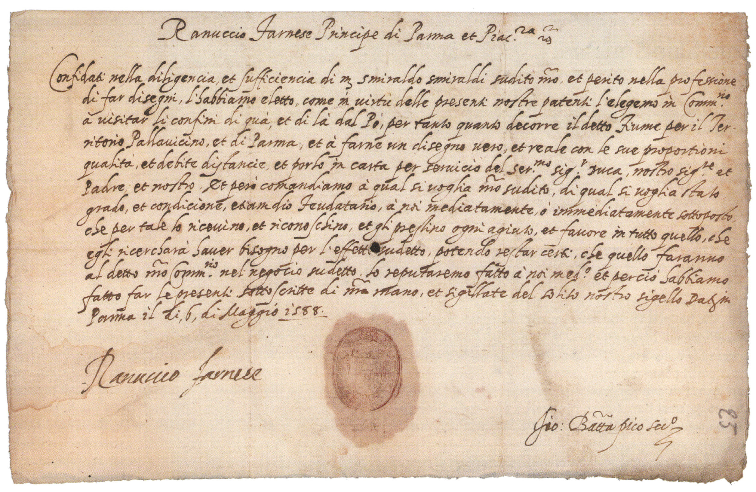
Over the years, the long history of the Canale Maggiore has been reported by many historians and researchers due to the important role played by the waterway in the city of Parma water system [36,37]. The canal origins date back to Theodoric, king of the Ostrogoths, who, in 493, undertook urban and water reorganization works in the city of Parma [38]. From the main course of the Parma River, south of the city, two artificial canals were created, the Comune and the Maggiore, used for irrigation and for the production of motive power for numerous mills that were built in the area. The etymology of the name “Maggiore”, in Italian, indicated a greater capacity and continuity of water presence throughout the year, compared to the “Comune”. The two canals, entering the city, joined and gave rise to the navigable Canale Naviglio [36,37]. The Canale Maggiore is approximately 20 km long and develops in a slightly sloping area; its waters, for centuries, have been used mainly to power mills that grounded cereals, and for the wool fulling and paper production. The first official Statutes concerning the governance of the canal appeared as early as 1353 [37]. These documents listed rules for cleaning, maintenance, common use, tax collection, and sanctions for the entire length of the waterway. The great and modern innovation was that the legal status attributed the ownership and responsibility for the management of the canal to a consortium of private individuals who were owners of the cereal and paper mills located on the Canale Maggiore. It will be around 1400 that the creation of a network of canals for Parma will be thoroughly considered to improve the city’s water supply. As from [37], the importance of waterways no longer consisted only in the irrigation potential of streams and rivers, but, also, since the 15th century onwards above all, in the canals which became a fundamental infrastructural support for the Renaissance city: navigable, and collectors or power generators for grinding and fulling. For all intents and purposes, the Maggiore and Comune canals were considered indispensable for the hydraulic network of the Parma area, and, for this very reason, their management became a priority. Moreover, in the municipal period, the waters in Parma were regulated. Then, in 1559, Ottavio Farnese, Duke of Parma and Piacenza [39], established a special office, made up of lay people and ecclesiastics, chaired by a lay person appointed by the Duke, who had full authority over rivers, canals and embankments, and bridges and roads, commonly known as Congregazione dei Cavamenti (Congregation of Quarries). On 26 July 1597, Ranuccio I Farnese definitively established its constitution, confirming it as a supreme court whose head was usually the governor. Smeraldo Smeraldi (1553–1634, engineer and cartographer, Figure 2) was designated as engineer of the Congregation by Prince Ranuccio Farnese.
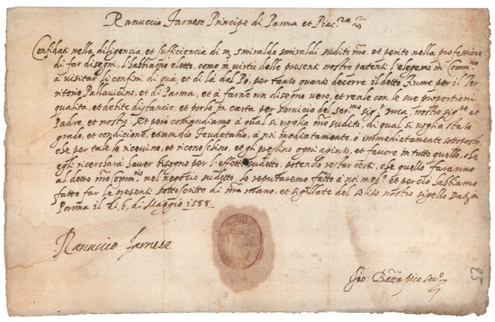
Figure 2.
License issued by Ranuccio Farnese, Prince of Parma and Piacenza, to Smeraldo Smeraldi on 6 May 1588 for the survey of the borders of the Duchy (in Italian, Parma State Archive).
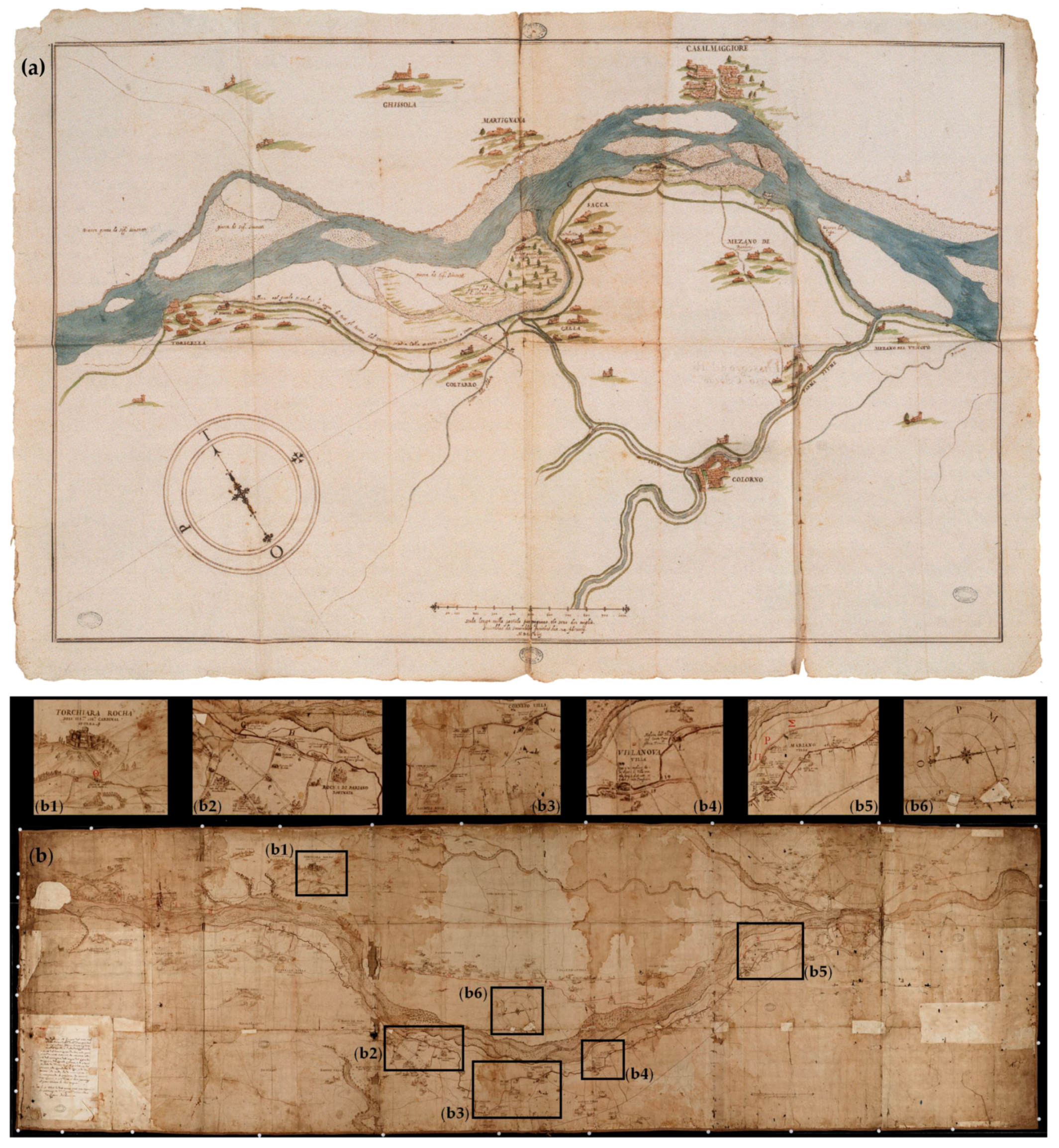
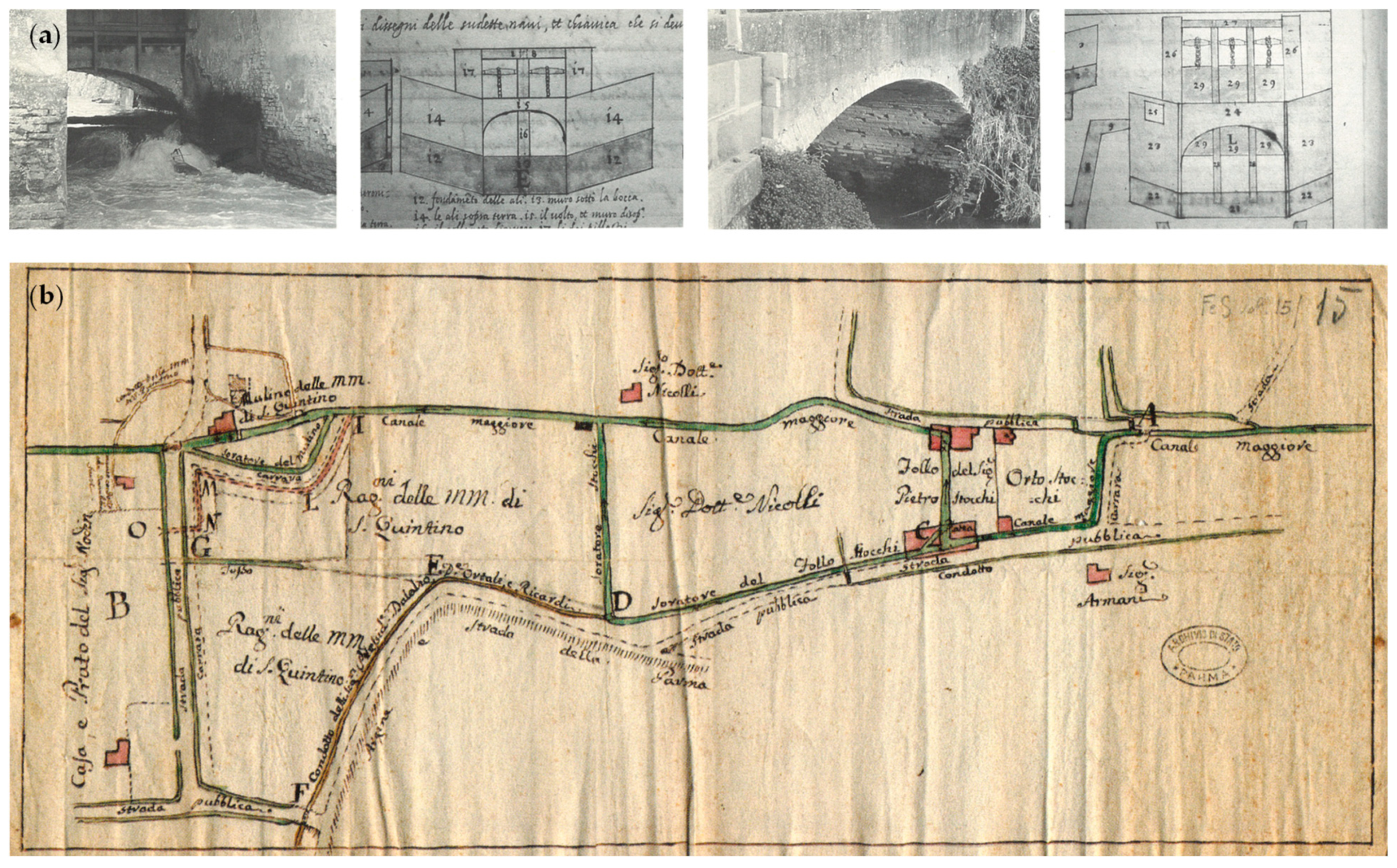
Smeraldo Smeraldi, dealing with the entire water system of the province of Parma and Piacenza, produced numerous maps of the territories of the Duchy (Figure 3a [40]). His skill as a surveyor, documented by multiple archival documents and maps, was praised by contemporaries for accuracy [16,41]. Countless maps and drawings made by Smeraldo Smeraldi concern the Canale Maggiore (examples in Figure 3b, Figure 4a, and Figure 5a).
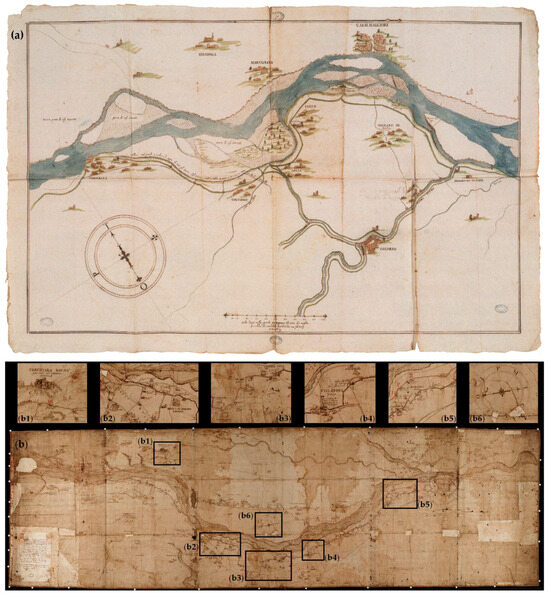
Figure 3.
(a) Stretch of the Po River and the tributary Parma River (Smeraldo Smeraldi, 1598) and (b) Parma River course from Langhirano to the city. Along the Canale Maggiore, running aside the Parma River right bank, mills, farmhouses, courtyards, and roads are depicted (b1–b6) with toponyms in Italian (270 × 79 cm, Smeraldo Smeraldi, 1599, Parma, State Archive, Congregation of Quarries maps, Vol. 14, 1).
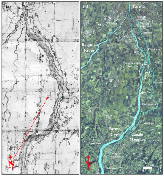
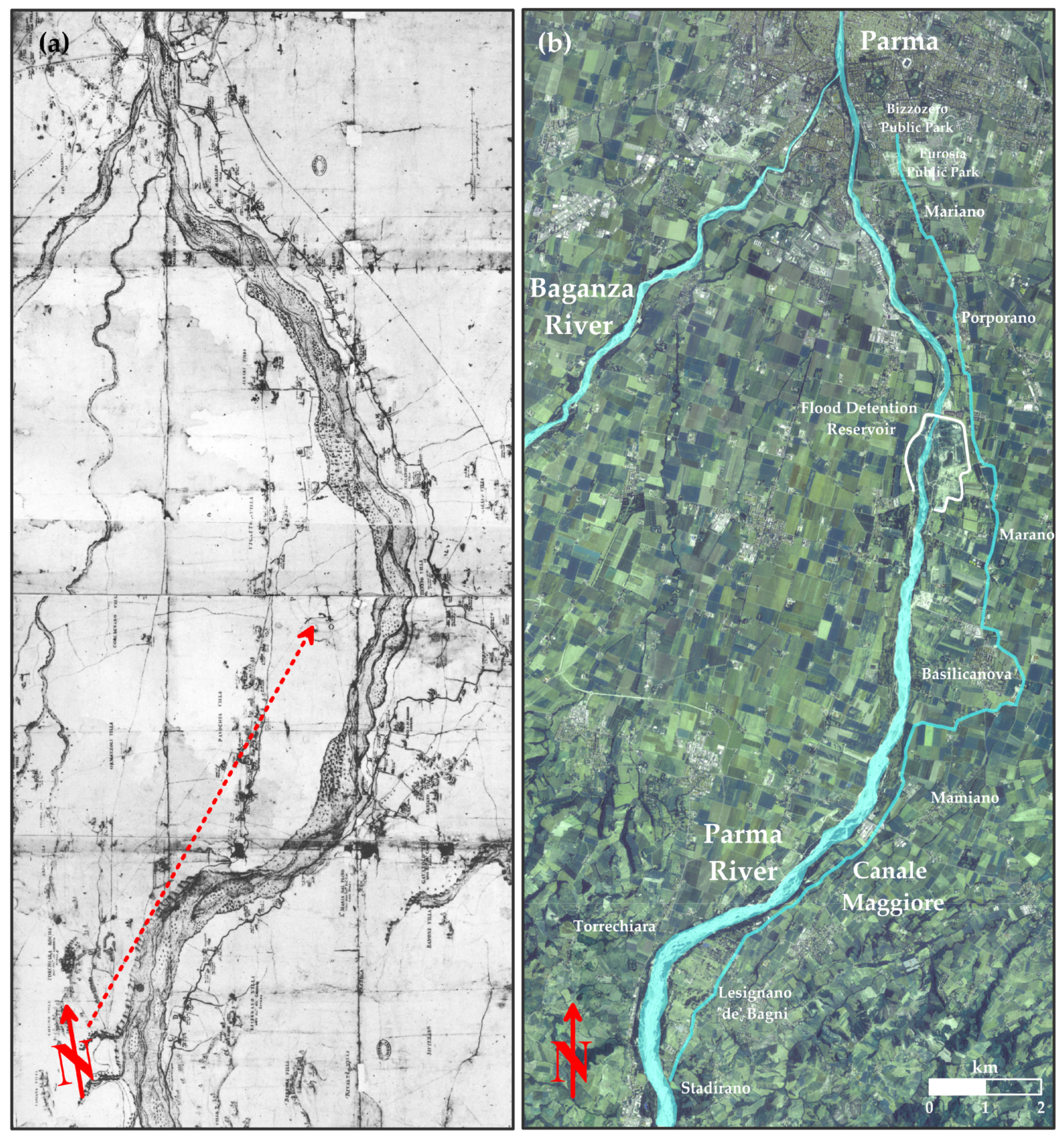
Figure 4.
(a) Parma and Baganza river system and layout of the Canale Maggiore in detail of the Smeraldo Smeraldi 1599 map of Figure 3b, compared with (b) current ortho-image of the Parma river system with the course of the Canale Maggiore and main inhabited centers evidenced. Please note the astonishing accuracy of the map drawn by Smeraldo Smeraldi over four hundred years ago, at the dawn of the 17th century, in reproducing the waterways and their orientation indicated by the red arrows (the arrow in Figure 4a is oriented approximately 10° towards the west from north, as from the direction present in detail on the Smeraldi map).
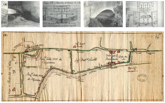
Figure 5.
(a) Hydraulic works along the Canale Maggiore in a representation by Smeraldo Smeraldi (1598, Parma, State Archive) and (b) mills along the course of the Canale Maggiore (anonymous, XVII century, Parma, State Archive).
In 1748, Philip, from the House of Bourbon, became Duke of Parma, Piacenza, and Guastalla, taking the name of Philip I of Parma, by the agreements made with the Treaty of Aachen, remaining in office until his death, replacing the Farnese house in the management of the city of Parma. The Congregation of Quarries also functioned under the Bourbon government with some amendments in its Statute and was suppressed in 1809. During its life, the Congregation of Quarries was very active in controlling the equitable distribution of the water of the Canale Maggiore. Simple rules, testified by many documents from the Parma historical archive, were dictated for the use of water and for its subdivision towards the nearby areas to be served. Management was not simple, since, for the production of hydraulic energy, a constant flow of water throughout the year was desired. This was the reason for the construction of an intake building to draw water from the Parma River.
For the entire Farnese period, the hydraulic energy produced by the Canale Maggiore was constantly available. The management of the Congregation of Quarries was good and the statute remained fairly unchanged [42]. Throughout the second half of the 18th century, the Congregation of Quarries managed the waters of the Canale Maggiore, realizing all the works necessary for its maintenance and for the regulation of the factories and paper mills located along the canal (Figure 5b). With the arrival of the French in Parma, the Congregation of Quarries was suppressed and the management of the canals of Parma was entrusted to a new direction of the Canale Maggiore Company which turned out to be inefficient. In 1815, with Duchess Maria Luigia (second wife of Napoleon I), an attempt was made to improve the management of the Canale Maggiore. Unfortunately, this project was never made operational [39]. Management continued inefficiently, even when new rules were formulated in 1820. In principle, nothing went beyond minimal administration, as practically happens today. From the 1930s, for the sake of healthiness and decorum of the city, the Canale Maggiore flows culverted from the southern outskirts of the city for the entire stretch crossing the urban center with the exception of a short stretch near a city park. As the years passed, the Canal Company continued to have a strictly administrative role, while, little by little, all the production structures closed, especially the mills closest to the city, also due to the scarcity of water.
2.2. Analysis of Main Initiatives Regarding the Canale Maggiore in Recent Years and the Progressive Decline of the Site
In 2009, the Municipality of Parma approved a Memorandum of Understanding for the “Redevelopment of water landscapes in the city of Parma” [43]. This document, signed in agreement between numerous public and private water government authorities and the Superintendence for Architectural and Landscape Heritage, emphasized the importance of water in the city of Parma and its territory as a significant natural resource, an element of communication, and a trace of a historical past not to be forgotten. In the same document, it is stated that “…the artificial waterways, which cross the city fabric with their hierarchy and specialization, over time were culverted, causing them to be forgotten in the rapid evolutionary process of the city, but still their signs remain clear in the stratification of the historic city and the toponyms of Parma”. The act approved by the Municipality of Parma aims to restore control of all the artificial canals that cross the city and lists a series of objectives for the protection, control, management, and new design and/or identification of promenades and spaces close to the water stretches aimed at creating quality places where people can walk, observe, and stop, also in relation to the requirements dictated by the European Landscape Convention [12]. Unfortunately, the application of the protocol was minimal, as was also noted in [44], which underlines the need for maintenance of the canal. As regards the improvement of the quality of the water flowing at the open-air section of the canal, local authorities’ contribution is deemed essential in planning interventions [45].
As from the direct observation of the authors, progressively, over the last twenty years, the canal has remained dry for many months of the year, thus resulting in it being distorted in its own true essence. Water amount has also significantly decreased in the winter months. The recent revisions of the original regulations of the Canale Maggiore Company have centralized power and control in the President, reducing the prerogatives of the members and penalizing the owners of the mini-hydro power plants. Management seems to be almost absent, and this leads to poor maintenance. Furthermore, the lack of water leads to structural damage to the buildings along the course of the canal, created in the past with a productive function, which have been often converted into civilian homes. The canal seems to be invisible and the new generations do not know of its existence, even if its waters have been of the utmost importance for the places. With the exception of the Parma and Baganza Rivers, the perception of the water landscape in the city of Parma, with particular reference to the numerous canals that crossed it in the past, has progressively diminished since the 16th century [46]. From this consideration derives the need to increase landscape–environmental sensitivity in the population through the identification and valorization of places capable of connecting the aesthetics of architecture to landscape redevelopment and environmental restoration. Over the last decades, the canals and the minor water network have lost value, being currently of little importance, managed on the basis of the few resources of the responsible companies which guarantee only the minimum functionality. To date, many years after [46] and after the Memorandum of Understanding signed in Parma in 2009 [43], little has changed and the conditions of the Canale Maggiore have even worsened.
2.3. Census of Sites of Interest Along the Canale Maggiore
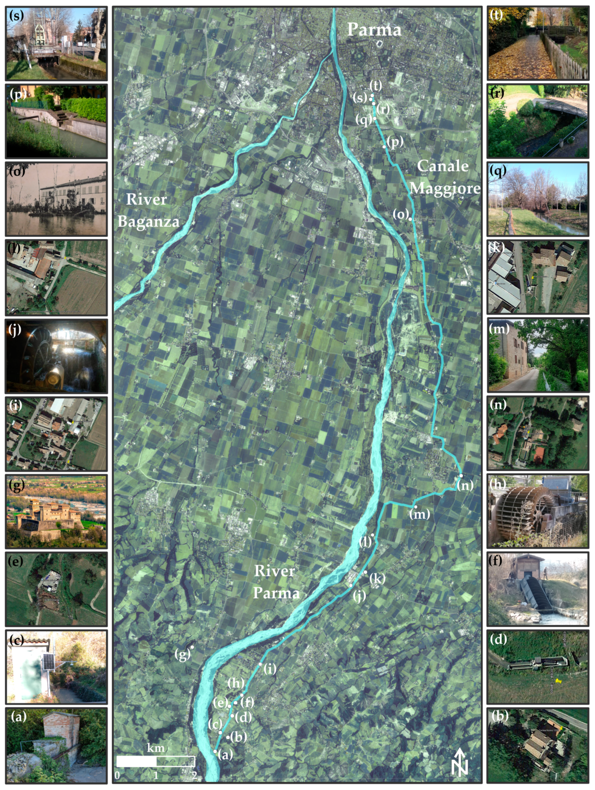
As anticipated, the Canale Maggiore extends for a length of just over 20 km, approximately in a south–north direction starting from the intake located in Stadirano down to the Parma city center (Figure 6). Numerous are the sites of interest located along the canal, including at least some historic mills [47] already indicated in the Smeraldo Smeraldi map in Figure 3 and Figure 4. Many sites of interest along the canal are shown, together with their locations, from Figure 6a–t. Starting from south, it is possible to recognize the old building of the intake structure (Figure 6a) and, just downstream of it, the old Stadirano mill dated 1555, now exploiting the available water head through an Archimedean screw turbine (AST) (Figure 6b). Downstream of the 1555 mill, a real-time stream gauging station is present, which allows the recording of water levels in the canal (Figure 6c). Further on, it is possible to identify another AST power plant, the first in Lesignano de’ Bagni (Figure 6d) and the Lesignano de’ Bagni waste collection area (Figure 6e) belonging to the municipality, followed by another AST power plant (Figure 6f). From the waste collection area, the view of the wonderful 15th-century castle of Torrechiara can be enjoyed (Figure 6g). A few hundred meters downstream, an ethical and organic farm, that also allows catering and provides leisure areas, is present, which can boast the presence of a mini hydro site equipped with a breastshot water wheel (Figure 6h). Always in the Lesignano de’ Bagni area, near some accommodation facilities and agritourism, a wide abandoned area (Figure 6i) is present. This occurs near a stretch of the canal not exploited from a hydroelectric point of view and at the end of which a small canal diverting part of the water resource is present, derived at the intake, back into Parma River due to inefficiency of some power plants, when using flow rates higher than 0.6 m3/s. This, unfortunately, severely limits the production potential of the following downstream plants.
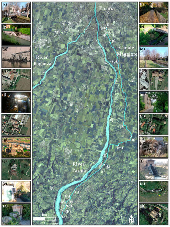
Figure 6.
Sites of interest along the course of the Canale Maggiore: (a) intake structure, (b) mill dated 1555, (c) real-time stream gauging station, (d) first Archimedean screw turbine (AST) in Lesignano de’ Bagni, (e) Lesignano de’ Bagni waste collection area, (f) second AST in Lesignano de’ Bagni, (g) Torrechiara castle, (h) water wheel at the Oasi Bianca farm site, (i) abandoned area in Lesignano de’ Bagni, (j) water wheel at the Mulino di Sopra restaurant, (k) AST in Mamiano, (l) mini hydro plant site in Mamiano, (m) route along the canal in Basilicanova, (n) Mulino di casa Sforza restaurant, (o) old postcard of the lake at the Porporano paper factory, (p) stairway to access the canal in Mariano, (q) Eurosia Park in Parma, (r) glimpse of the Canale Maggiore in a private garden, (s) trash rack cleaning machine, and (t) the Canale Maggiore in Bizzozero Park in Parma.
At the end of the described reach is located the mill named Mulino di Sopra [47], already represented in the Smeraldo Smeraldi 1599 map and now converted to a restaurant, where a breastshot water wheel is fully functional and visible from the dining room (Figure 6j). A short distance downstream, it is still possible to notice another AST power plant, built in the vicinity of an ancient court (Figure 6k), and, a few hundred meters further, another mini-hydro site is present (Figure 6l). Well-preserved courtyard buildings of significant interest are present along the course of the canal in Basilicanova (an example in Figure 6m) in the stretch of the watercourse that precedes another historic mill also converted to a restaurant (Mulino di casa Sforza), where the available water head is exploited through another breastshot water wheel (Figure 6n). Approaching the city, along a quite long stretch of the canal, only minor private exploitations, not entirely accessible, are present. Further ahead, several paper production factories, abandoned or still in operation but which no longer exploit hydraulic driving force, are present. Notable is the paper factory site on Strada Serra [41], adjacent to the neoclassical Villa Solari del Bono [48], and now converted to residential use. There was even an artificial lake near a paper mill now converted into a residential complex (image from local old postcards in Figure 6o). Still proceeding towards the city, it is possible to recognize civil works useful in the past for the exploitation of the canal waters (an example in Figure 6p) and pleasant stretches of the waterway that cross public parks (Figure 6q) or very well-kept private gardens in which the dedication of the owners fully highlights the pleasantness of such a resource when adequately cared for (Figure 6r). In the terminal portion of the open-air stretch, it is also possible to observe some hydraulic devices for retaining floating materials (Figure 6s) and recent civil works realized in correspondence with the crossing of a city park, aimed at enhancing the watercourse in a context very popular with citizens (Figure 6t). Once the city is reached, the canal is roofed and disappears from view, flowing underground after a very significant bed drop not currently exploited for hydroelectric purposes and entering the Canale Naviglio. The many elements of interest of different types (productive, cultural, and recreational) present along the canal lead to considering the feasibility of an overall re-evaluation of the waterway worthy of further study.
2.4. Study of the Current Layout of the Canale Maggiore and Evaluation of Its Hydroelectric Potential
In this section, some considerations are formulated regarding the canal characteristics and the availability of the water resource, for the purpose of a realistic assessment of the hydroelectric producibility of existing or to be installed mini hydroelectric plants. This aspect is analyzed with reference to the main elements that characterize the production of hydroelectric energy, i.e., the available discharge Q and its distribution during the year, and the available head H, increasing with the watercourse bed slope.
2.4.1. Elevation Profile of the Canal Bed
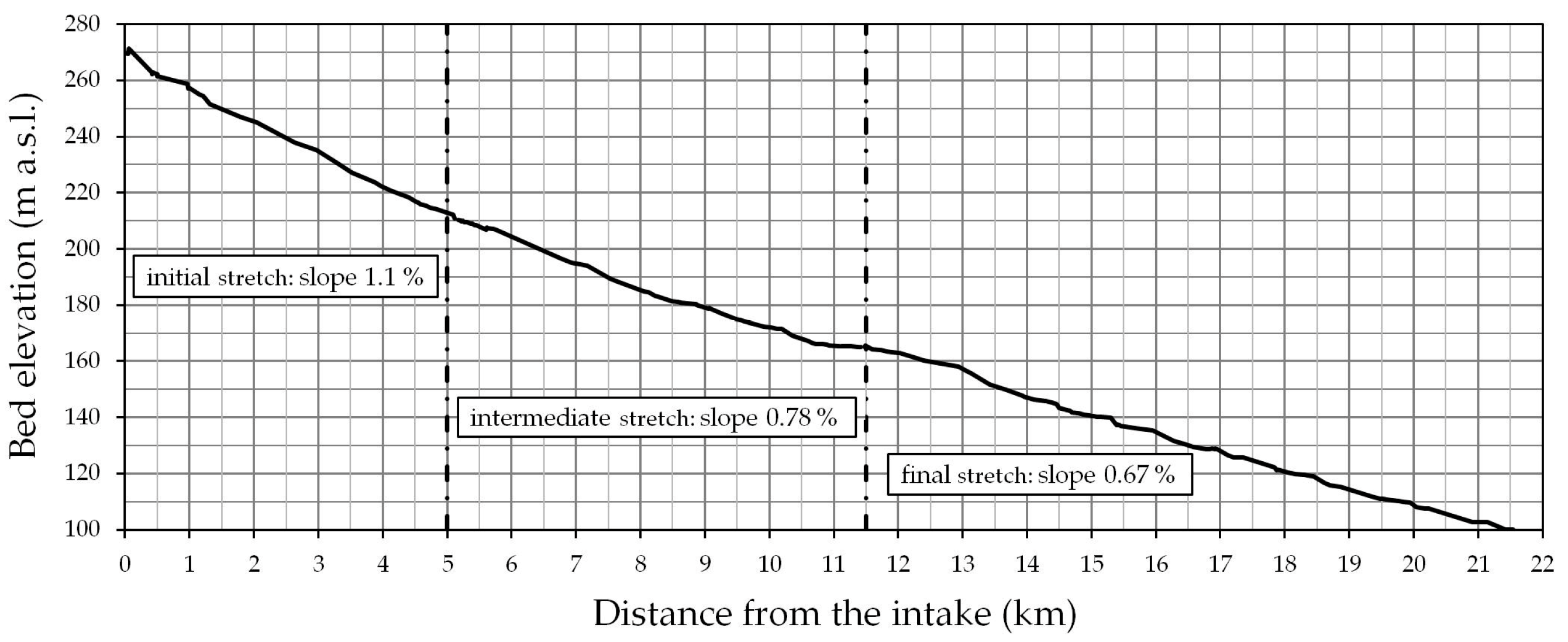
With reference to the course of the Canale Maggiore starting from the intake structure (Figure 6a) down to the Bizzozero Park (Figure 6t), the elevation profile is here presented (Figure 7). The bed elevation data along the canal course were acquired through a GNSS receiver Emlid Reach Rs 2. As can be recognized from the figure, the canal can be roughly divided into three stretches characterized by different bed slopes which almost halve from upstream to downstream. The information is useful for formulating some considerations relating to the evaluation of the potential for run-of-river hydroelectric energy production. The combination of high flow rates and steep watercourse gradients results in a higher potential for power generation [49]; the first stretch of the canal (5 km long) is therefore the most favorable in terms of hydroelectric exploitation. As can also be observed from Figure 6, at least four plants are, in fact, present in this portion of the canal, characterized by a greater slope and available discharge, and, therefore, ensuring greater heads and, as a consequence, greater producibility with overall lower plant costs. The stretch ends approximately in correspondence with the channel diverting excess flow back to Parma River. Proceeding downstream, the number of installed power plants per km decreases, even if both the available flow rate and the bed gradients remain significant and suitable for mini-hydro applications. Furthermore, the presence of favorable localized conditions that can still allow the construction of new mini-hydro plants is, at some places, even guaranteed and will be discussed in the following section.
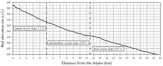
Figure 7.
Bed elevation profile for the Canale Maggiore.
2.4.2. Maximum Derived Discharge at the Intake
Given the uncertainty relating to the knowledge of the maximum flow rate that can be conveyed by the watercourse in its current state, a direct measurement was carried out just upstream of the second AST site in Lesignano de’ Bagni (Figure 6f) in correspondence with a suitable cross-section whose geometry was for the purpose obtained through geometric relief. The discharge was measured by acquiring water velocities at more than ninety points using a propeller-type current meter on eighteen verticals placed at a mutual distance between 0.1 and 0.2 m, and an interpolated velocity field (Figure 8) was derived for the considered cross section. The processing of the measured data allowed the value of the flow rate Q to be estimated at 1.03 m3/s with a maximum depth of 0.46 m. Given the characteristics of the sections in the stretch considered, it is believed that the canal conveyance could even be increased by at least 25% as a result of modest interventions on the riverbed, at least for the first portion of the canal.

Figure 8.
Interpolated velocity field at the cross-section of interest and velocity measuring points.
2.4.3. Flow Duration Curve
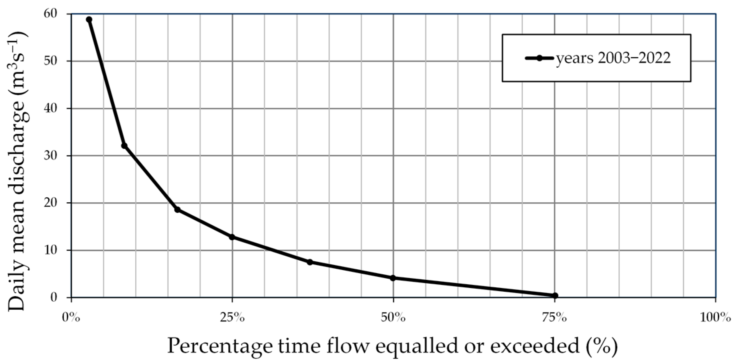
Indispensable for the evaluation of hydroelectric producibility is the knowledge of the period in which the water resource is available in the watercourse and, therefore, can be exploited. This information is synthesized by the flow duration curve (FDC), usually available at water level measuring stations along the streams. Since no stations are available for the Parma River near the Canale Maggiore intake, reference was made to the flow duration curve at Ponte Verdi, located in the city center (about 20 km downstream of the intake), which is nevertheless adequate for the evaluation of the percentage time flow which is equaled or exceeded, even in the upstream stretches, due to the characteristics of the river and the basin. The considered flow duration curve is presented in Figure 9 with reference to the period 2003–2022 [50]. A summer drought lasting approximately 90 days is evident and this corresponds to a maximum period of about 275 days in which a flow can be observed in the Parma River allowing the canal to be fed. The almost total absence of flows in the summer period requires the utmost attention to safeguarding the exploitation of the resource, available only for 75% of the year. From a climate change perspective, it is legitimate to ask whether the conditions observed in the last twenty years can remain valid for the years to come. A broad scientific debate is nowadays underway regarding FDCs. However, given the complexity of the chain of phenomena that lead to the formation of flows in natural watercourses, to date, there is no definitive answer to the question, and very complex studies should be conducted at the basin scale [51,52]. In the context of applications to minor and artificial watercourses, especially in the case of a very modest derived discharge with reference to the average daily flow rate of the main watercourse (<10%), however, a possible future reduction in average outflows is expected to exert only minimal impacts on the derived flow rate, once the intake structure has been adequately designed [53].
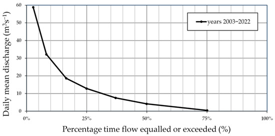
Figure 9.
Flow duration curve for the Parma River at the Ponte Verdi gauging station.
2.4.4. Water Level Gauging Station on the Canale Maggiore
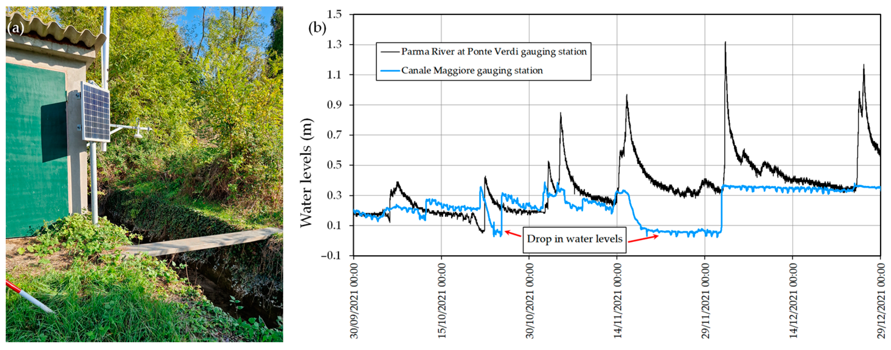
Only recently, a real-time stream gauging station has been set up just downstream of the intake to record the values of the water levels to evaluate the discharge captured by the intake structure (Figure 10a). The water levels recorded at the station allow some considerations to be made if compared with those available for the Parma River at the, already introduced, Ponte Verdi gauging station (Figure 10b). As can be observed, the occurrence of flood events on the Parma River is not rarely followed by a sudden very significant drop in the water levels recorded at the Canale Maggiore gauging station also when the discharge in Parma River is significant. This is a sign of obstruction of the intake due to the transport of debris during floods, a condition that requires interventions to restore the efficiency of the system. It is clear that the availability of the measuring station is of strategic importance to ensure better management of the resource necessary for hydroelectric production.
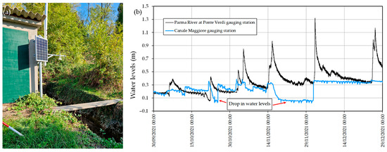
Figure 10.
(a) Water level gauging station on the Canale Maggiore (site of Figure 6c) and (b) example of sudden drops in water levels due to obstructions during floods in Parma River.
2.4.5. Mini-Hydro Existing Plants Along the Canale Maggiore: Hydroelectric Producibility and Simplified Technical–Economic Analysis
Along the canal, there are at least ten privately owned mini-hydro plants of different types (ASTs, water wheels, and Kaplan turbines). Some of these plants are easily accessible as they are built on state-owned areas; others are located in private areas but where it is still possible to appreciate their view and functioning; and only few are in private areas which are currently not freely accessible to the public. Evaluating the hydroelectric producibility and the remuneration of the energy produced for each of the mini-hydro plants is not trivial as this requires detailed knowledge about the characteristics of each derivation (often based on pre-existing and non-optimized hydraulic works) and access to sensitive data regarding hydroelectric concessions and incentive policies related to the use of renewable sources depending on the time of construction. However, the installed power can be evaluated without too much difficulty with reference to a flow rate Q of 0.85 m3/s and a net head H of 3 m (design characteristics of the AST system in Figure 6f). Assuming an overall efficiency η of 0.7, reasonable for a system of this type [21,22,54], it is possible to estimate a power P of about 18 kW for the considered plant (P = η·9.81·Q·H in kW). Assuming operation for 275 days (6600 h), the energy produced annually is equal to approximately 120 MWh with a yearly remuneration of about €18,000, given the favorable incentive tariff accessed in the concession year (155 €/MWh). Adopting a power plant cost estimated at €4450/kW [55,56,57] and assuming a discount rate of 3.5%, the economic evaluation carried out computing the NPV of the investment for a period of thirty years envisages a payback period of just over 6 years and an internal rate of return (IRR) of almost 14%. This particularly favorable condition obviously depends on the discount rate and the remuneration of the MWh; however, the NPV of the investment still remains positive and significant, given the same discount rate, even if the energy remuneration drops, as an example, to €110/MWh. In this case, the payback period is raised to 10 years and a decrease in the IRR to around 9% is observed. Similar evaluations could be carried out, also with reference to mill 1555 (Figure 6b), for the same flow rate Q and a much greater head H, equal to over 5 m. In this case, the annual remuneration for the energy produced would be approximately €30,000.
As expected, the simplified economic analyses conducted confirms that this kind of investment is still sufficiently robust and advantageous [58], even in the presence of any reductions in energy remuneration, an aspect which is not particularly critical at present. This confirms the validity of the choice of repowering and optimizing of existing plants and also suggests the realization of further mini-hydro plants where favorable local conditions are identified. However, this is all true provided that the overall efficiency of the intake work and the canal is guaranteed and that the flow rate considered is actually available, with the expected continuity, during the year.
2.5. Analysis of Main Critical Issues Affecting the Watercourse
2.5.1. Intake Structure
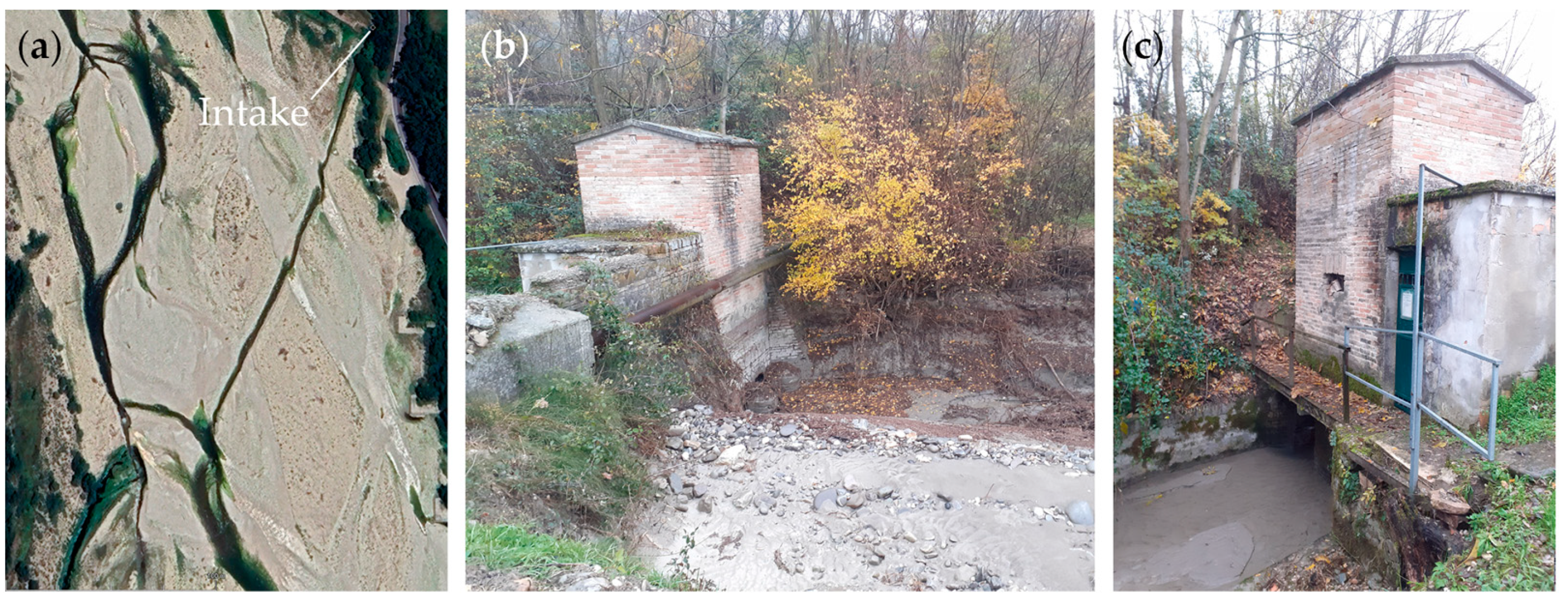
The characteristics of the existing intake structure, unfortunately, greatly penalize the exploitation of the resource in the canal. As already pointed out, during the floods of the Parma River, which generally occur in the months of the year in which the availability of the resource would be at its maximum, the current intake structure is subject to obstruction, being not adequately protected from the significant transport of debris (Figure 10 and Figure 11). This requires timely intervention and the removal of deposited material to ensure the system’s efficiency. Unfortunately, the actual possibility of carrying out interventions in the Parma riverbed has to be authorized by the waterways governing bodies and, therefore, is subject to considerable bureaucratic delays. As a consequence, in the periods of greatest availability of the resource, mini-hydro plant shutdowns are very frequent and, unfortunately, last for several days (if not weeks), with serious economic damage in terms of lack of energy production.
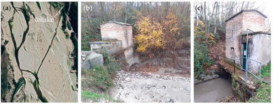
Figure 11.
Intake from Parma River: (a) aerial view of the channel dug into the riverbed to allow the collection of water from the Parma River, (b) upstream view of the old intake building after a severe flood event that caused the obstruction of the system, and (c) downstream view of the intake building after the same flooding event: still water is present in the canal due to the obstruction.
2.5.2. Canal Management
The current governance appears to be in great difficulty in terms of managing the canal and does not appear particularly far-sighted towards the site as a whole, not at all enhancing its cultural heritage and not recognizing its potential role in the current and future context and suitability to respond to present and future needs. Perhaps, also due to a limited availability of economic resources, maintenance interventions along the course of the canal are scarce, both in terms of vegetation management, and also whenever significant critical issues occur regarding buildings due to bank instability consequent to discontinuities in the presence of flow in the watercourse. Therefore, general conditions of abandonment and degradation are observed which have a very negative impact on the quality of the rural and even urban environment crossed by the canal. Furthermore, hydroelectric production, which could represent a valid and current resource to boost the rebirth of the site, does not seem to be particularly enhanced and safeguarded and is penalized by the poor overall efficiency of the system. The construction of mini-hydro plants is not particularly valued, and, consequently, the design of private plants has not been adequately supported in the past. Plant inefficiencies are indeed not infrequently observed, due to incorrect sizing of mechanical and civil works.
2.6. Analysis of the Research Context
Countless examples of ancient artificial systems of small waterways, having an agricultural or productive and manufacturing vocation, can be identified worldwide, in addition to the two already mentioned in the Introduction, related to the Ricote Valley in Spain and the Derwent Valley in Great Britain. Among these, some interesting examples are presented in Table 1.

Table 1.
Examples of waterways systems deemed worthy of regeneration.
The common denominator regarding these experiences is the recognition of the intrinsic value of waterways and the territories they cross. Not rarely, they can indeed experience a new existence as leisure or tourism sites or in other forms. The methods of revaluation of the sites are varied, and, depending on their original characteristics, ranging from the sole daylighting of roofed canals, to the creation of new opportunities for eco-tourism and outdoor recreation activities, even to the reconversion of the production settlements present along the banks of the waterways. We are now, therefore, often witnessing the abandonment of the archaic concept that saw artificial canals as anachronistic impediments to urban renewal and the recognition of waterways as essential infrastructures of the new urban landscape, in addition to the respectful attestation of the cultural heritage brought as a gift from the sites.
3. Results
In the context of the analysis conducted thus far, a series of ideas, aimed at valorizing in a current key the legacy represented by the Canale Maggiore under a cultural and productive profile, is provided in the following.
3.1. Valorization of the Hydroelectric Resource
In order for hydroelectric exploitation to be effectively guaranteed, a first intervention should be the complete reconstruction of the intake structure also incorporating the effects of climate change and sustainability criteria into the design of the new infrastructure [53], albeit according to the criteria of maximum simplicity in order to contain costs. This would guarantee the availability of the resource constantly for about nine months per year and plant shutdowns could be averted. According to [27,71], the expense could be in the order of a few hundred thousand euros, which could also be obtained (in whole or at least partially) by the Canale Maggiore Company through public financing related to the sustainability of energy production from renewable sources. In the impossibility of significant interventions on the structure, due to a lack of economic resources, a timely maintenance plan should be mandatory in order to restore favorable conditions for resource capture in the case of obstruction.
Another aspect of great importance is the retrofitting and repowering of existing power plants and the optimization of the related mechanical and civil works. This would guarantee an increase in the overall production of clean energy of the whole system. To this end, it would be appropriate for the private owners of the plants to be duly supported in the context of public interventions justified by the intrinsic value connected to the revaluation of the whole site. The elimination of bottlenecks represented by plants that do not allow the processing of high flow rates would also make it possible to guarantee a higher energy production downstream of the site of Figure 6j, with positive consequences for the entire system. In the long stretch between the power plants of Figure 6h,j, currently devoid of hydroelectric exploitations, a new plant could be located at the site of Figure 6i in Lesignano de’ Bagni, currently abandoned, easily reachable and close to a very pleasant area from a landscape point of view. The realization of a new public plant in this area could be very interesting, which, due to its size and characteristics, is suitable for the realization of a center of attraction from a recreational and educational point of view related to the issues of sustainability and energy production from renewable sources. Always concerning the realization of new mini-hydro power plants, as suggested in [46], it would be possible to realize a derivation of a small discharge from the flood detention reservoir in Marano (Figure 6) delivering the flow into the Canale Maggiore stretch present along the reservoir embankment, with the dual advantage of clean energy production and the maintenance of a higher flow in the canal.
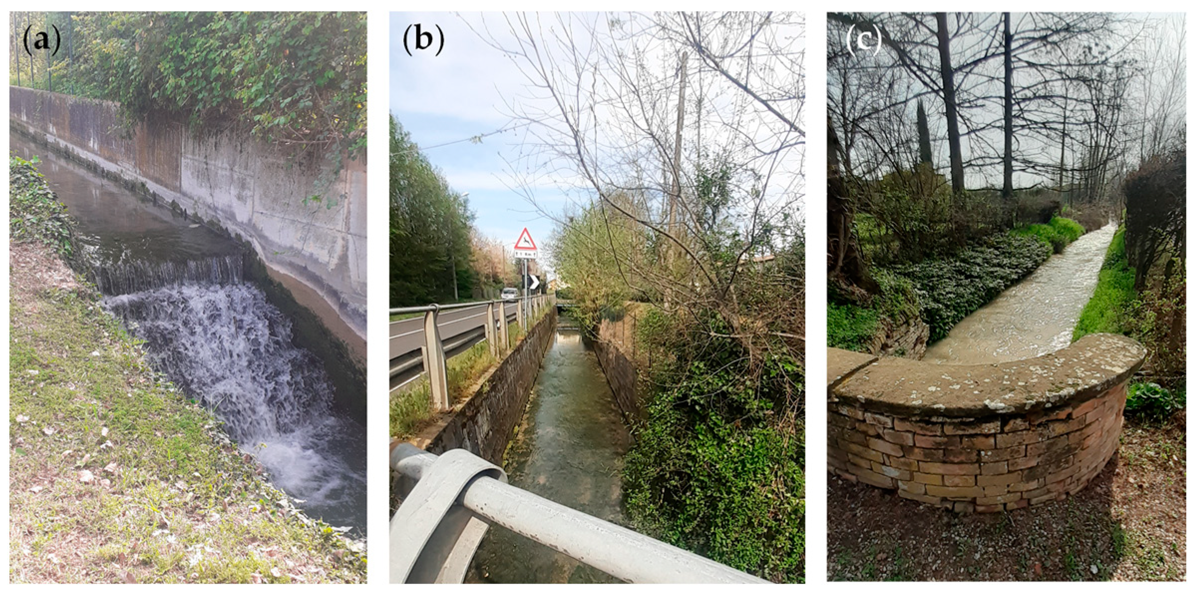
Another very interesting and underestimated aspect is that relating to the exploitation of the Canale Maggiore for the realization of real field research activities for hydroelectric applications. In low-, ultra-low-, or zero-head conditions with a small flow velocity, promising technologies for generating hydropower are represented by a low head (up to a couple of meters) and hydrokinetic turbines, wherein the kinetic energy of the flow is converted into mechanical power. One of the main advantages of hydrokinetic technology (e.g., employing Savonius-type rotors) over other choices is the ability to exploit existing infrastructures and avoid long plant construction times. Minimal environmental impact is the key feature encouraging the use of this kind of turbine [72], whose main drawback is the lower efficiency. Therefore, the research in this area is ongoing and focused on improving performance through innovative design [73,74]. Since the ecological status of water streams is an important concern in the hydropower sector, devices with a higher survival rate should be preferred to avoid damage to fishes [32,75]. In addition new kinds of high-efficiency, nowadays, magnet-free electric generators deserve an investigation as a solution for micro-hydropower plants [76]. The opportunity offered by real field experimental sites available for the in-depth study of such installations is valuable. The availability of a real field channel in the presence of a flow rate of almost 1 m3/s is not common, not even for many research organizations, and several experimental investigations could be conducted in the canal according to different technologies. Available bed drops and stretches where the canal runs embedded alongside the road are in fact suitable for setting up VLH power stations, without fear of backwater effects [28,32,75] (Figure 12a,b). Other sites, such as those of Figure 6s,t and Figure 12c, could be exploited for the setting up of hydrokinetic power stations based on the adoption of Savonius-type rotors [35,72,77,78]. Both of these technologies are cutting-edge with regard to the exploitation of the residual hidden hydroelectric potential available in existing infrastructures, currently receiving a lot of attention. In addition, a rather high bed drop currently not used, present at the end of the stretch considered (downstream of the site of Figure 6t), could be duly exploited through a traditional mini-hydro system. Citizens’ awareness related to renewable energies could be improved and promoted through proper communication campaigns and dedicated information installations at the nearby public park.
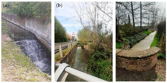
Figure 12.
Exploitable sites along the canal for real field research applications: (a) bed drop, (b) embedded canal stretch, and (c) stretch suitable for real field hydrokinetic experimentation.
3.2. Creation of Cultural and Educational Opportunities
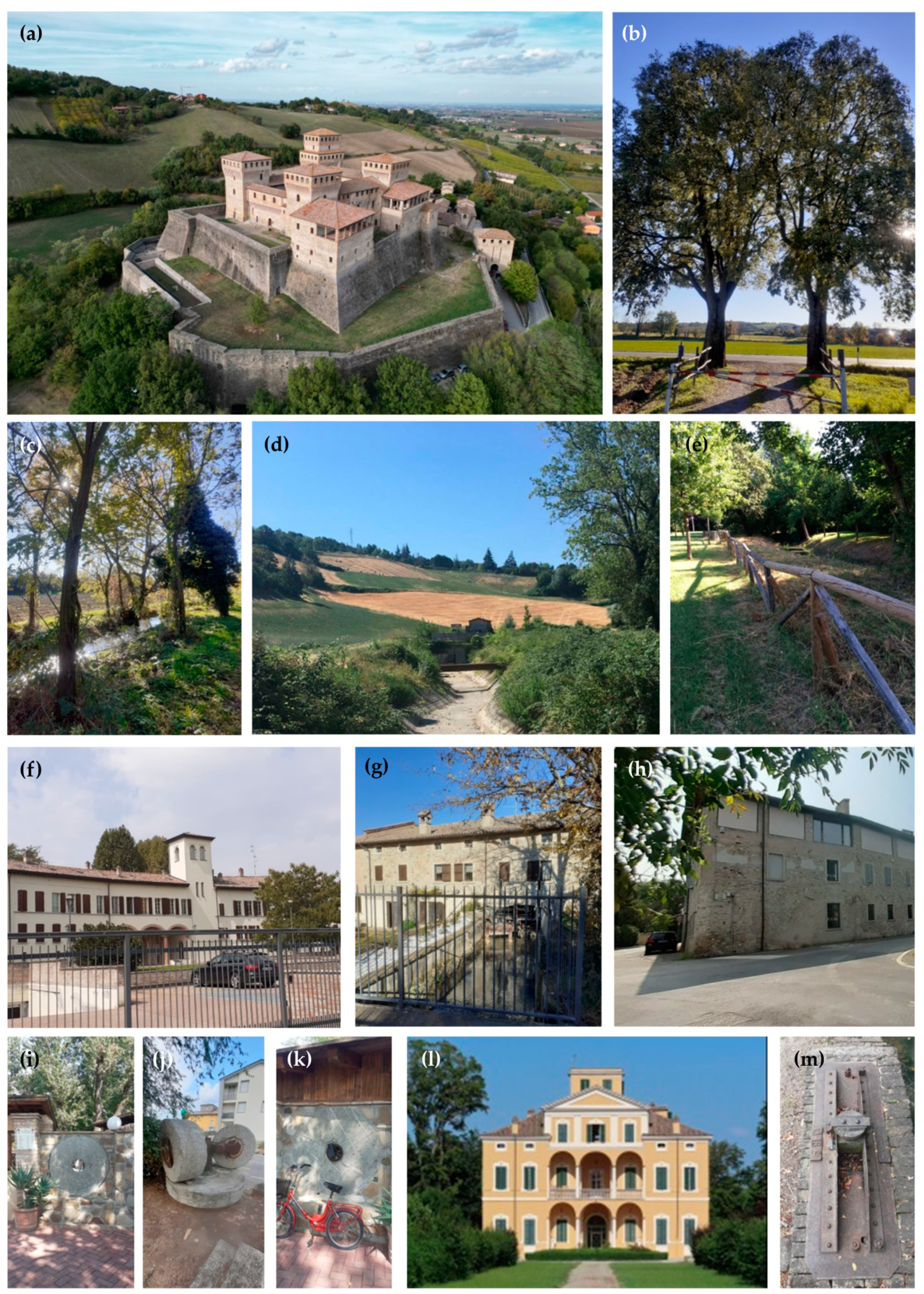
As a whole, the Canale Maggiore could offer various cultural and educational opportunities worthy of valorization. Currently, detailed knowledge regarding the origins of the canal and its productive vocation is mainly the prerogative of researchers in the landscape and history sectors and derives essentially from the link with the ancient regulation of waters in the city of Parma [16,38]. Although traces of the original vocation of the waterway survive in numerous toponyms (“mill road”, “paper makers’ art road”, etc.) and are used as ornaments (Figure 13i–k), often not even the closest residents really know what the role of the canal was in past centuries and up until a few decades ago.
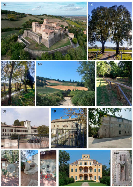
Figure 13.
Pleasant views and sites of interest along the Canale Maggiore: (a) Torrechiara Castle, (b) countryside along the canal, (c) the canal near to Lesignano de’ Bagni, (d) the dry canal in summer upstream an AST site, (e) the canal crossing a city public park, (f) mill at a paper factory converted to residential, (g) head race of the Mulino di Sopra (Figure 6j), (h) paper factory converted to residential, (i–k) memories of milling activity in everyday life in Lesignano de’ Bagni, (l) Villa Solari Del Bono in Porporano, and (m) an example of the many hydraulic devices diverting the waters onto the off-taking channels of the Canale Maggiore irrigation network.
The use of water as a driving force, exploited by mills along the canals, supported the productive activities that characterized the local economy for a long time. Artificial waters were, in fact, the primary settlement infrastructures allowing the birth of specialized production districts, influencing the growth of the city and the urban architecture [16]. By leveraging the strong connection with the city, the creation of a shared narrative with the Canale Maggiore site could create a broader constructive involvement of citizens, scholars, and local communities, also making use of new information and communication technologies in order to visualize the canal and its representation in the historical maps presented in the previous sections, and the ancient factories in their different ages, thus encouraging new forms of interaction between society, cultural heritage, places, and landscape values [79]. This can certainly coexist synergistically with educational proposals more directly focused on the production of renewable energy which arises from the ashes of ancient milling and paper production activities of the past. The source of inspiration for the re-evaluation of the site in a playful and educational sense could be the examples of activities conducted in numerous museums or educational laboratories where the reality, between nature and science, and past and future, is illustrated through experimentation, discovery, and play (MUSE in Trento and MUST in Milan, and Cotton Warehouses in Genova, Italy). With this aim, visits to the mini-hydro plants along the canal and an illustration of the methods and characteristics of hydroelectric energy production could be organized, in collaboration with the owners, enhancing their role and initiative, recognizing the social value of the district in terms of education to sustainability. Several areas are suitable for the creation of sites dedicated to cultural and educational activities [80]. Among these can be identified the area at the site of Figure 6i and the waste collection area of Lesignano de’ Bagni, close to the AST site of Figure 6f, already in the process of relocation. This last area is also a privileged position for observing the Torrechiara castle (Figure 13a) and could be provided with simple facilities designed to better allow the use of the places (e.g., gazebos and picnic benches). Closer to the Parma city center, another area suitable for the creation of an educational site can be identified at the Bizzozero park near the stretch of the canal shown in Figure 6t, already recognized as suitable for the setting up of real field hydroelectric experimentation. It is essential that the planning of these interventions is preceded by a careful analysis of the local reality. This will allow the identification of virtuous examples in the local territory, and to draw inspiration from them to envisage a concrete and effective use of places and spaces, avoiding the risk of creating a born-and-dead reality.
3.3. Creating Opportunities for Recreation and Physical Activity
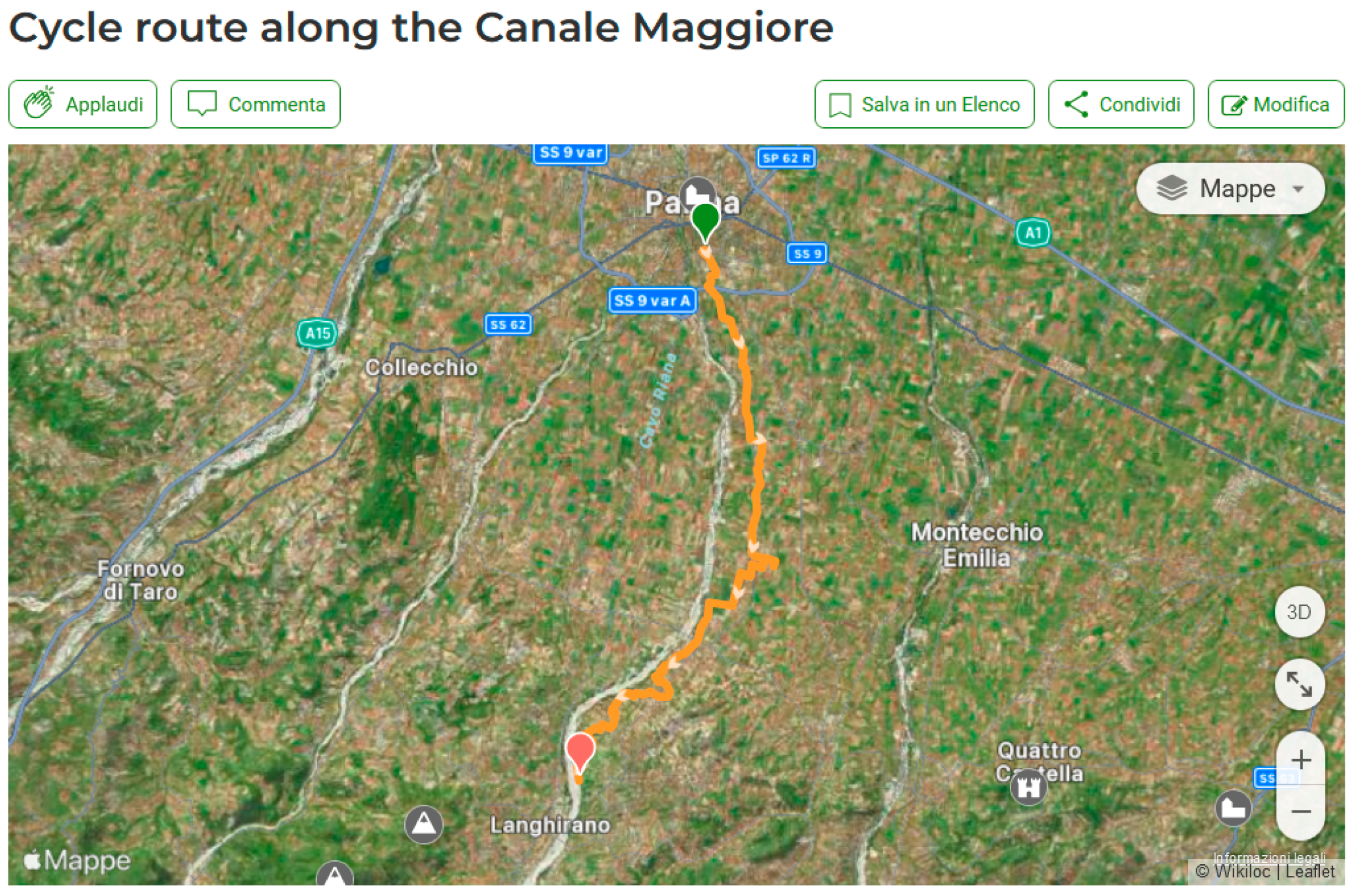
The city of Parma has always boasted a great vocation among its citizens for the use of bicycle in daily life. It is no coincidence that, in 2020, the city won the Urban Award conferred by the association of Italian Municipalities (ANCI) for virtuous municipalities that support projects related to cycling and sustainable mobility [81], and that the entire municipal territory is excellently served by paths that allow cyclists to leave the city center in total safety for more than 130 km [82]. The creation of a new cycle path connecting the city and the extra-urban area also satisfies the OG4 objective of the General Plan for Urban and Extra-urban Cycling Mobility of the Italian Ministry of Sustainable Infrastructure and Mobility, aimed at promoting the creation of long-distance itineraries interconnected with each other by enhancing the tourist cycle paths already under construction as a component of the network [83]. The hilly environment close to the city of Parma has great potential for the slow mobility and open-air cultural tourism as a result of its scenic beauty, the presence of numerous historical sites, and the food and wine riches offered by the area. Therefore, leisure and physical activity can represent another opportunity to enhance the Canale Maggiore site as a whole, identifying a network of recreational cycling routes with historical, cultural, and clean energy production sites located along the banks of the canal as their destination [80]. It is necessary to identify specific needs and implement specialized services for the success of this activity, and this is not complex for an area in which the use of the bicycle has been growing sharply in recent years. Moreover the costs and interventions necessary for the design of a cycle route on urban and extra-urban roads are, fortunately, modest [84,85]. In addition to the continuity of the cycle paths and their connection with the urban center, attractiveness is another necessary requirement [85]. The attractiveness factor is related not only to the features of the cycle path but is linked to the appeal of the sites of interest reachable along the pathways and to the surrounding landscape. In this sense, along the Canale Maggiore, all the necessary conditions exist to define a cycle itinerary of significant interest for cyclists of any level (Figure 13). Starting from the center of the city of Parma, it is possible to identify a series of low-flow urban roads close to or even running alongside the canal (Figure 14) from which it is also possible to rejoin an existing extra-urban cycle path much appreciated by citizens (“La Voladora”), from which the remaining course of the canal can be skirted up to the intake structure.
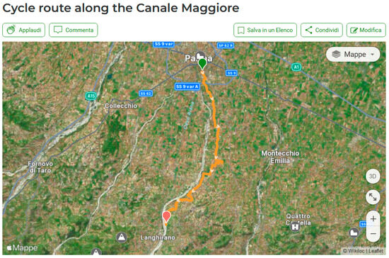
Figure 14.
Cycle route along the Canale Maggiore from Parma to the canal intake proposed by the authors in the Wikiloc App.
This existing itinerary, which extends over a total distance of 25 km with a difference in altitude of approximately 200 m, therefore considered as an easy-to-follow route, runs along the floodplain of the Parma River, offering lovers of the environment and outdoor sports a dedicated route, also practicable on foot and on horseback, connecting Lesignano de’ Bagni and Parma [86]. Rest areas and water supply areas could be set up along the new cycle route, as well as explanatory panels and totems illustrating the points of interest in the context of the waterway’s area of influence. Significant stages of the route can also be identified in at least three mini-hydro sites where a catering business is present (Figure 6h,j,n), which could provide services for cycle tourists travelling along the itinerary dedicated to the Canale Maggiore. Given the context related to sustainable energy production from renewable sources, charging stations for battery devices (electric bikes, smartphones, etc.), using solar power, or even powered by the energy produced by the hydroelectric plants located on the canal should be provided along the cycle route. Due to the waiting time, the stations should be preferably installed at pleasant points of interest for the cyclists to visit during recharge [87]. A route for the cycle path along the Canale Maggiore was identified by the authors and is already available [88] (Figure 14).
4. Discussion
In the management of heritage sites, the focus is often exclusively on conservation, not rarely avoiding contemporary use. As a consequence, frequently, this leads to the “removal” of heritage sites from the living and current experience of the community that “owns” the heritage itself. In this way, the full range of tools available is not exploited, largely due to the emphasis on conservation. Although, sometimes, this can be justified by the presence of few tangible testimonies of a past reality of some importance, it can even happen that the trace of a significant legacy, capable of imprinting its memory in the habits and toponyms of a territory, is lost. This often occurs in minor vernacular sites. Often, due to the abandonment of the structures and the lack of knowledge about their value, we even desist from their preservation. However, as the World Heritage Convention states, the permanence of the values of a heritage place is achieved not only through the conservation of the built environment but by making the site meaningful in the daily life of the community [1]. The issue of preserving even minimal evidence of manufacturing activities must, in all respects, be indeed considered central, as was also established by the Nizhny Tagil Charter for the Industrial Heritage [89]. This document establishes the universal value of sites and buildings dedicated to productive activities as essential constituents of the history of civilization and its progress, and, as such, recognizes their fundamental importance. Great dignity is given even to minimal testimonies, even immaterial and intangible, capable of constituting records of the lives of ordinary men and women, providing an important sense of identity. Supported by historical research, the identification, recording, and protection of any type of industrial heritage is defined as “necessary”, since any industrial heritage should be seen as an integral part of cultural heritage in general. The sympathetic adaptation and re-use of sites are considered appropriate for enabling their survival and should be supported and encouraged to be included in development policies. Stimulating citizens’ interest and affection towards industrial heritage and appreciation of its values is a way to preserve it.
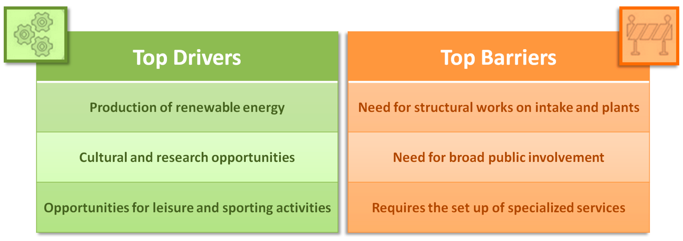
Transdisciplinary approaches can allow us to glimpse virtuous valorization strategies even in very degraded contexts. For this reason, we tried to address the issue of conservation of the historical and cultural heritage of the artificial waterway of interest, starting from a technical perspective inspired by the former productive vocation of the district. As a result of the impulse given by the Europe Green Deal [90,91] and the REPowerEU [92] plan that promote the massive upscaling and speeding-up of renewable energy in power generation, it was possible to outline the main features of a valorization intervention, based on the roots of the exploitation of the energy of the waters that dates back to a very distant past. The real feasibility of this technical proposal must obviously be assessed on the basis of effective planning and economic evaluation tools. The better the estimate made of the costs and economic potential deriving from the activities aimed at restoring the hydroelectric exploitation of the watercourse, the greater the chances of a successful outcome of the intervention. Fortunately, relating to this type of application, the technical–scientific literature provides multiple estimation tools that allow us to evaluate the best strategy, whether one wishes to obtain greater power, maximizing long-term profit, or whether one intends to carry out a modest intervention, aimed mainly at the conservation of cultural heritage and the stimulation of cultural interest. Perhaps, more immediately recognizable, the cultural, educational, useful, and pleasant leisure and entertainment values linked to the Canale Maggiore and the crossed territory are evident and deserve to be understood and rediscovered as a whole to revitalize this legacy. However, the overall implementation of the intervention requires that, on each of the three main fronts, different challenges relating to the realizations of studies and projects, that require the involvement of public and private entities, be addressed (Figure 15).
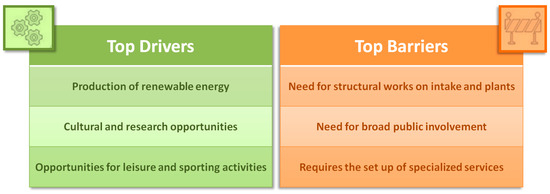
Figure 15.
Top drivers and barriers of the process.
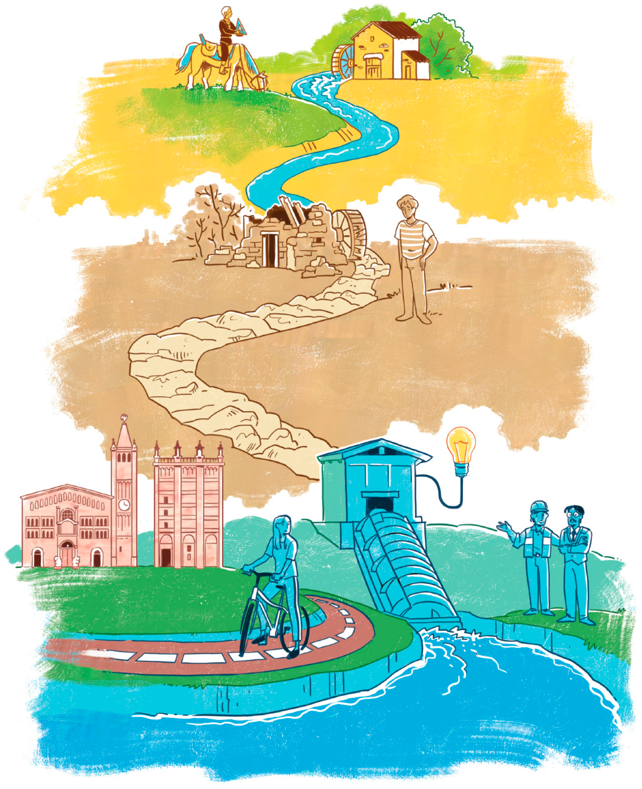
Restoring and maintaining a portion of the landscape turns out to be useful for the well-being of the place and its inhabitants. Let us not forget what the European Convention states: “‘Landscape’ means an area, as perceived by people, whose character is the result of the action and interaction of natural and/or human factors”. Landscape heritage has value and relevance for today, and canals and rivers are indelibly connected to important events in history, and none of the earth’s societies would be as advanced as they currently are without them. Waterways also reflect the difficulties of peasant life and directly or indirectly make food available for people [93]. If, in past centuries, the environmental settlement system was essentially based on a production process, today, given that that mechanism has almost disappeared, it must become something else: a tourist route, a sports space, a stop to relax, or, more simply, a place to observe, and preserve as a historical testimonial memory of a particular landscape. The water system, however, is not only the founding factor of an urban structure, but, through the relationships that water establishes with the territory over time, it also becomes one of the main characters defining the typologies of the prevalent architecture. Therefore, depending on the roles that water has assumed over the course of history, now as an element of communication or defense, now as a support for nutrition, now for tourism promotion, today, we can recognize peculiar landscapes, rich in memories, signs, and suggestions. The Canale Maggiore falls into that category of a highly transformed landscape which needs to recover an identity. What has made the canal almost unrecognizable is, first of all, the absence of water. It is, therefore, necessary to operate both on the water side and promote knowledge of this historic watercourse towards the community. Helping the population to look after their territory through proper strategies could mean repopulating it for present and future use (Figure 16). Repopulating a place means helping to stop the decline of the territory and the forgetting of the past. The degraded state of maintenance of the canal today, whether it crosses cultivated areas or public parks, changes completely when the waterway enters private gardens, in which the beauty and perception of the canal are greatly improved. Therefore, to observe a place with the attentive gaze of those who care for it, can become not only an intention but a real power. In this way, an attitude of design, and of careful and conscious conservation is produced.
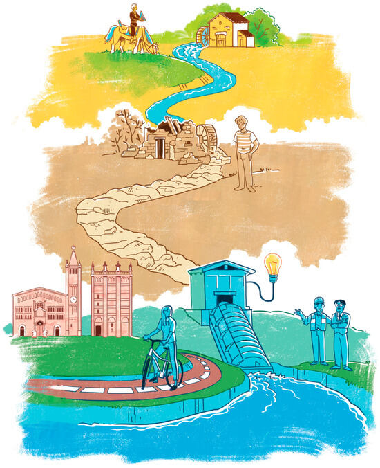
Figure 16.
Gone is the glory of the golden age, when Smeraldo Smeraldi on horseback through the paths of the Duchy surveyed the canal geometry, and, crossing the age of decline and loss of meaning of the present time, a revaluation of the Canale Maggiore is now glimpsed through a conscious focusing on the hydroelectric, cultural, and recreational vocation of the site. However, many challenges have to be faced, and only a transdisciplinary approach and the strong will of the Parma community will allow us to rediscover this significant cultural heritage.
5. Conclusions
According to a point of view that involves a transdisciplinary approach, the aim of this work is to propose ideas aimed at supporting the rediscovery of a minor cultural heritage rich in history, and highlight the opportunities inherent in its valorization. In the considered case, recognizing water as a common thread capable of linking past, present, and future allows us to read and exploit in a contemporary key the anthropic transformations of the landscape and the works intended for the hydraulic regulation and exploitation of an artificial waterway. From a sustainable perspective, this study encourages public involvement in the enhancement of local heritage on the basis of three different proposals regarding energy production from renewable sources and cultural and educational, as well as recreational and physical activity initiatives. The protection and valorization of minor cultural heritage sites of the European continental landscape represent an open challenge requiring significant efforts and further applied research, along with practices capable of considering the characteristics and specificities of the sites and their possible contemporary role in the social and productive reality of the area they belong to. Future efforts need to focus on community engagement, the potential of digital technologies, and the creation of heritage narratives and experiences to achieve conservation by making the places or objects of legacy a living element of citizens’ everyday experience.
Author Contributions
Conceptualization, F.A. and M.E.M.; methodology, F.A. and M.E.M.; software, F.A.; investigation, F.A., M.E.M. and C.B.; data curation, F.A., M.E.M. and C.B.; writing—original draft preparation, F.A. and M.E.M.; writing—review and editing, F.A., M.E.M. and C.B.; supervision, F.A.; funding acquisition, F.A. All authors have read and agreed to the published version of the manuscript.
Funding
This research was granted by University of Parma through the action Bando di Ateneo 2022 per la ricerca co-funded by MUR-Italian Ministry of Universities and Research—D.M. 737/2021—PNR–PNRR–NextGenerationEU.
Data Availability Statement
The raw data supporting the conclusions of this article will be made available by the authors upon request.
Acknowledgments
Marco D’Oria is kindly acknowledged for his support during the flow measurements. Nazarena Bruno is kindly acknowledged for her support during the canal topographic survey. For Figure 16 we thank the freelance illustrator Elena Dall’Aglio [@elena_dallaglio].
Conflicts of Interest
The authors declare no conflicts of interest.
References
- UNESCO—United Nations Educational Scientific and Cultural Organisation. Convention Concerning the Protection of the World Cultural and Natural Heritage; UNESCO: Paris, France, 1972. [Google Scholar]
- Grimwade, G.; Carter, B. Managing Small Heritage Sites with Interpretation and Community Involvement. Int. J. Herit. Stud. 2000, 6, 33–48. [Google Scholar] [CrossRef]
- Alberts, H.C.; Hazen, H.D. Maintaining authenticity and integrity at cultural World Heritage sites. Geogr. Rev. 2010, 100, 56–73. [Google Scholar] [CrossRef]
- Benni, S.; Carfagna, E.; Torreggiani, D.; Maino, E.; Bovo, M.; Tassinari, P. Multidimensional measurement of the level of consistency of farm buildings with rural heritage: A methodology tested on an Italian case study. Sustainability 2019, 11, 4242. [Google Scholar] [CrossRef]
- ICOMOS—International Council on Monuments and Sites. Charter on the Built Vernacular Heritage; ICOMOS: Charenton-le-Pont, France, 1999. [Google Scholar]
- Zhang, J.; Wang, G.; Wang, Y.; Zhang, J. Stakeholder Perspectives on the Preservation and Development of Lower Grade Historic Buildings. Int. J. Hist. Archaeol. 2020, 24, 502–516. [Google Scholar] [CrossRef]
- Sardaro, R.; La Sala, P.; De Pascale, G.; Faccilongo, N. The conservation of cultural heritage in rural areas: Stakeholder preferences regarding historical rural buildings in Apulia, southern Italy. Land Use Policy 2021, 109, 105662. [Google Scholar] [CrossRef]
- Dal Sasso, P.; Caliandro, L.P. The role of historical agro-industrial buildings in the study of rural territory. Landsc. Urban Plan. 2010, 96, 146–162. [Google Scholar] [CrossRef]
- Fuentes, J.M.; García, A.I.; Ayuga, E.; Ayuga, F. The development of the flour-milling industry in Spain: Analysis of its historical evolution and architectural legacy. J. Hist. Geogr. 2011, 37, 232–241. [Google Scholar] [CrossRef]
- Groth, P. 1. Frameworks for Cultural Landscape Study. In Understanding Ordinary Landscapes; Yale University Press: New Haven, CT, USA, 2022. [Google Scholar]
- Council of Europe. Convention for the Protection of the Architectural Heritage of Europe; Conseil de l’Europe/Section des Publications: Granada, Spain, 1985. [Google Scholar]
- Council of Europe. European Landscape Convention; Council of Europe: Florence, Italy, 2000. [Google Scholar]
- Russo, P.; Riguccio, L.; Carullo, L.; Tomaselli, G. Using the Analytic Hierarchical Process to Define Choices for Re-Using Rural Buildings: Application to an Abandoned Village in Sicily. Nat. Resour. 2013, 4, 323–332. [Google Scholar] [CrossRef]
- Convenzione di Faro. Available online: https://ufficiostudi.beniculturali.it/mibac/export/UfficioStudi/sito-UfficioStudi/Contenuti/Pubblicazioni/Volumi/Volumi-pubblicati/visualizza_asset.html_917365394.html (accessed on 5 November 2024).
- Rossi, M. Waterways in surveys and drawings: Water management and the geometric patterns of the landscape around Parma. Draw.—Ideas Images 2003, 26, 10. [Google Scholar]
- Rossi, M. Learning from the past: Water heritage. landscape patterns around parma. In Putting Tradition into Practice: Heritage, Place and Design: Proceedings of 5th INTBAU International Annual Event 5; Lecture Notes in Civil Engineering; Springer: Cham, Switzerland, 2018; Volume 3. [Google Scholar]
- Heider, K.; Quaranta, E.; García Avilés, J.M.; Rodriguez Lopez, J.M.; Balbo, A.L.; Scheffran, J. Reinventing the wheel—The preservation and potential of traditional water wheels in the terraced irrigated landscapes of the Ricote Valley, southeast Spain. Agric. Water Manag. 2022, 259, 107240. [Google Scholar] [CrossRef]
- Guerriero, L.; Di Napoli, M.; Novellino, A.; Di Martire, D.; Rispoli, C.; Lee, K.; Bee, E.; Harrison, A.; Calcaterra, D. Multi-hazard susceptibility assessment using analytic hierarchy process: The Derwent Valley Mills UNESCO World Heritage Site case study (United Kingdom). J. Cult. Herit. 2022, 55, 339–345. [Google Scholar] [CrossRef]
- Hein, C. Adaptive Strategies for Water Heritage: Past, Present and Future; Springer Nature: Cham, Switzerland, 2020. [Google Scholar]
- IRENA. World Energy Transitions Outlook 2023: 1.5 °C Pathway; International Renewable Energy Agency: Abu Dhabi, United Arab Emirates, 2023. [Google Scholar]
- Simmons, S.C.; Lubitz, W.D. Archimedes screw generators for sustainable micro-hydropower production. Int. J. Energy Res. 2021, 45, 17480–17501. [Google Scholar] [CrossRef]
- Quaranta, E.; Pujol, T.; Grano, M.C. The repowering of vertical axis water mills preserving their cultural heritage: Techno-economic analysis with water wheels and Turgo turbines. J. Cult. Herit. Manag. Sustain. Dev. 2023, 13, 269–287. [Google Scholar] [CrossRef]
- Picone, C.; Sinagra, M.; Gurnari, L.; Tucciarelli, T.; Filianoti, P.G.F. A New Cross-Flow Type Turbine for Ultra-Low Head in Streams and Channels. Water 2023, 15, 973. [Google Scholar] [CrossRef]
- Quaranta, E.; Bódis, K.; Kasiulis, E.; McNabola, A.; Pistocchi, A. Is There a Residual and Hidden Potential for Small and Micro Hydropower in Europe? A Screening-Level Regional Assessment. Water Resour. Manag. 2022, 36, 1745–1762. [Google Scholar] [CrossRef]
- Vincent Denis, A.C.; Punys, P. Integration of Small Hydro Turbines into Existing Water Infrastructures. In Hydropower—Practice and Application; Books on Demand: Norderstedt, Germay, 2012. [Google Scholar]
- European Commission Renewable Energy Directive (2009/28/EC). Official Journal of the European Union. 2009. Available online: https://eur-lex.europa.eu/LexUriServ/LexUriServ.do?uri=OJ:L:2009:140:0016:0062:en:PDF (accessed on 20 August 2024).
- Kishore, T.S.; Patro, E.R.; Harish, V.S.K.V.; Haghighi, A.T. A comprehensive study on the recent progress and trends in development of small hydropower projects. Energies 2021, 14, 2882. [Google Scholar] [CrossRef]
- Quaranta, E.; Bonjean, M.; Cuvato, D.; Nicolet, C.; Dreyer, M.; Gaspoz, A.; Rey-Mermet, S.; Boulicaut, B.; Pratalata, L.; Pinelli, M.; et al. Hydropower case study collection: Innovative low head and ecologically improved turbines, hydropower in existing infrastructures, hydropeaking reduction, digitalization and governing systems. Sustainability 2020, 12, 8873. [Google Scholar] [CrossRef]
- Butera, I.; Balestra, R. Estimation of the hydropower potential of irrigation networks. Renew. Sustain. Energy Rev. 2015, 48, 140–151. [Google Scholar] [CrossRef]
- Russo, M.A.; Carvalho, D.; Martins, N.; Monteiro, A. Forecasting the inevitable: A review on the impacts of climate change on renewable energy resources. Sustain. Energy Technol. Assess. 2022, 52, 102283. [Google Scholar] [CrossRef]
- Morosi, J.; Amarilla, B.; Conti, A.; Contin, M. Estancias of buenos aires province, Argentina: Rural heritage, sustainable development and tourism. Int. J. Herit. Stud. 2008, 14, 589–594. [Google Scholar] [CrossRef]
- Bahreini, A.; Riasi, A.; Quaranta, E.; Nourbakhsh, A. Numerical and experimental study of a very low head (VLH) turbine in an open channel at no-load conditions. Sustain. Energy Technol. Assess. 2023, 60, 103429. [Google Scholar] [CrossRef]
- Clancy, M. Slow Tourism, Food and Cities: Pace and the Search for the “Good Life”; Routledge: New York, NY, USA, 2017. [Google Scholar]
- Timothy, D.J. Contemporary cultural heritage and tourism: Development issues and emerging trends. Public Archaeol. 2014, 13, 30–47. [Google Scholar] [CrossRef]
- Sarma, K.C.; Biswas, A.; Misra, R.D. Experimental investigation of a two-bladed double stage Savonius-akin hydrokinetic turbine at low flow velocity conditions. Renew. Energy 2022, 187, 958–973. [Google Scholar] [CrossRef]
- Trascinelli, D. Le Acque della Parma ed il Canale Maggiore: Derivazioni Antiche e Recenti da Capoponte a Panocchia; Donati: Parma, Italy, 1978. [Google Scholar]
- Zanlari, P. Tra Rilievo e Progetto: Idrografia e Rappresentazione del Territorio nel Parmense: Il Caso del Canale Maggiore; Università degli studi di Parma: Parma, Italy, 1985. [Google Scholar]
- Rossi, M. Strade d’acqua: Navigli, Canali e Manufatti Idraulici nel Parmense: Dal Rilievo del Territorio al Disegno del Paesaggio; Mattioli 1885: Fidenza, Italy, 2004; ISBN 8889397004. [Google Scholar]
- Mclver, K.A. Venturelli Roberto, La corte Farnesiana di Parma (1560–1570): Programmazione artistica e identità culturale. Renaiss. Q. 2002, 55, 1072–1074. [Google Scholar] [CrossRef]
- Masotti, L.; Stocchi, F. Itinerari di Smeraldi—Rappresentazione e Governo del Territorio Nell’opera di un Cartografo Farnesiano (1580–1634); CIERRE: Parma, Italy, 2022; ISBN 978885520197I. [Google Scholar]
- AA.VV. Io Smeraldo Smeraldi Ingegnero et perito della Congregatione dei Cavamenti; Comune di Parma: Parma, Italy, 1980. [Google Scholar]
- Masotti, L. From Land Surveying to the Council of State. The Cocconcelli of Parma, Cartographers and Engineers (1760–1884). Boll. Della Soc. Geogr. Ital. 2008, I, 169–182. [Google Scholar]
- Municipality of Parma Paesaggi d’acqua: L’Acqua al Centro dei Progetti di Riqualificazione Urbana e Architettonica. Available online: https://www.comune.parma.it/notizie/comunicati/SICUREZZA/2009-10-23/comunicato-stampa_2009-10-23_698.aspx (accessed on 20 August 2024).
- Carluccio, R. Nuovo Canale Maggiore: Da un’immagine di Degrado a una Proposta di Riqualificazione. Available online: https://www.wateronline.info/2012/01/11/nuovo-canale-maggiore-da-unimmagine-di-degrado-a-una-proposta-di-riqualificazione/ (accessed on 20 August 2024).
- Sibilla, S.; Sciandra, M.C.; Rosso, R.; Lamera, C. Hydraulic approach to Navigli canal daylighting in Milan, Italy. Sustain. Cities Soc. 2017, 32, 247–262. [Google Scholar] [CrossRef]
- Belicchi, M.; Matta, F.; Pessarelli, N. Riqualificazione dei paesaggi d’acqua nella città di Parma. In Cento proposte per lo spazio pubblico; Conforti, P., Naddeo, P., Eds.; Agenzia per la qualità Urbana del Comune di Parma: Parma, Italy, 2010; p. 7. [Google Scholar]
- De Lucis, F.; Morselli, A.; Rubin, L. Acqua Masnada—Mulini e Mugnai dell’Appennino Reggiano e Parmense; Consorzio fra Produttori e Cooperative Agricole: Reggio Emilia, Italy, 1990; ISBN REA0002864. [Google Scholar]
- Catalogo generale dei Beni Culturali Villa Solari Del Bono (Parma, 1775–1879). Available online: https://catalogo.beniculturali.it/detail/ArchitecturalOrLandscapeHeritage/0800244283 (accessed on 20 August 2024).
- Ballance, A.; Stephenson, D.; Chapman, R.A.; Muller, J. A geographic information systems analysis of hydro power potential in South Africa. J. Hydroinform. 2000, 2, 247–254. [Google Scholar] [CrossRef]
- Annali idrologici 2023—Arpae Emilia-Romagna. Available online: https://www.arpae.it/it/temi-ambientali/meteo/report-meteo/annali-idrologici/annali-idrologici-2023.zip/view (accessed on 28 August 2024).
- Ramião, J.P.; Carvalho-Santos, C.; Pinto, R.; Pascoal, C. Hydropower Contribution to the Renewable Energy Transition Under Climate Change. Resour. Manag. 2023, 37, 175–191. [Google Scholar] [CrossRef]
- Wasti, A.; Ray, P.; Wi, S.; Folch, C.; Ubierna, M.; Karki, P. Climate change and the hydropower sector: A global review. Wiley Interdiscip. Rev. Clim. Change 2022, 13, e757. [Google Scholar] [CrossRef]
- Ferdowsi, A.; Piadeh, F.; Behzadian, K.; Mousavi, S.-F.; Ehteram, M. Urban water infrastructure: A critical review on climate change impacts and adaptation strategies. Urban Clim. 2024, 58, 102132. [Google Scholar] [CrossRef]
- Alonso-Martinez, M.; Sierra, J.L.S.; Díaz, J.J.D.C.; Martinez-Martinez, J.E. A New Methodology to Design Sustainable Archimedean Screw Turbines as Green Energy Generators. Int. J. Environ. Res. Public Health 2020, 17, 9236. [Google Scholar] [CrossRef] [PubMed]
- Madrid, M.E.; Toro, J.M.; Ortega, S. Hydrodynamic Screws as an Alternative for Small Hydropower Generation in Colombia. WIT Trans. Ecol. Environ. 2015, 195, 15–23. [Google Scholar]
- Ogayar, B.; Vidal, P.G. Cost determination of the electro-mechanical equipment of a small hydro-power plant. Renew. Energy 2009, 34, 6–13. [Google Scholar] [CrossRef]
- Gichamo, T.Z.; Popescu, I.; Jonoski, A.; Solomatine, D. River cross-section extraction from the ASTER global DEM for flood modeling. Environ. Model. Softw. 2012, 31, 37–46. [Google Scholar] [CrossRef]
- Kaldellis, J.K. The contribution of small hydro power stations to the electricity generation in Greece: Technical and economic considerations. Energy Policy 2007, 35, 2187–2196. [Google Scholar] [CrossRef]
- View of Unveiling Milan’s Navigli and Underground Water Heritage through Integrated Urban (Water) Design. Available online: https://bluepapers.nl/index.php/bp/article/view/122/110 (accessed on 23 October 2024).
- Carroll, P.J. Open and Shut: Circulating People and Goods, Pollution, and History in the Canals of Suzhou. J. Urban Hist. 2024. [Google Scholar] [CrossRef]
- Geijo, J.M.; Sanchez-Lite, A.; Zulueta, P.; Sampaio, A.Z.; Sola, R.; Geijo, J.M.; Sanchez-Lite, A.; Zulueta, P.; Sampaio, A.Z. Study of an “Artefact” of the Castilla Canal: Reconstruction of the Missing Machinery. Machines 2022, 10, 239. [Google Scholar] [CrossRef]
- Harvey-Fishenden, A.; Macdonald, N.; Bowen, J.P. Dry weather fears of Britain’s early ‘industrial’ canal network. Reg. Environ. Chang. 2019, 19, 2325–2337. [Google Scholar] [CrossRef]
- Lennon, J.J. Transforming Waterways: The Tourism-Based Regeneration of Canals in Scotland. In Heritage and Tourism in Britain and Ireland; Palgrave Macmillan: London, UK, 2016; pp. 85–97. [Google Scholar]
- Ricart, S.; Politecnico, C.; Milano, D. Valuating and promoting cultural heritage from historical canals. Lessons from the Baix Ter region (Catalonia). In Proceedings of the International Conference on Global Tourism and Sustainability—Tourism, Lagos, Portugal, 12–14 October 2016. [Google Scholar]
- Ricart, S.; Ribas, A.; Pavón, D.; Gabarda-Mallorquí, A.; Roset, D. Promoting historical irrigation canals as natural and cultural heritage in mass-tourism destinations. J. Cult. Herit. Manag. Sustain. Dev. 2019, 9, 520–536. [Google Scholar] [CrossRef]
- Honek, D. Tourist potential of Weisshuhn’s race in Žimrovice in the Opava region. In Public Recreation and Landscape Protection—With Environment Hand in Hand, Proceedings of the 13th Conference; Mendel University in Brno: Czech Republic, 2022. [Google Scholar]
- De La Peña, J.L.; Salgot, M. History of an irrigation canal: The “Real Canal de la Infanta”, Barcelona, Spain. Int. J. Glob. Environ. Issues 2016, 15, 169–178. [Google Scholar] [CrossRef]
- Maw, P.; Wyke, T.; Kidd, A. Canals, rivers, and the industrial city: Manchester’s industrial waterfront, 1790–18501. Econ. Hist. Rev. 2012, 65, 1495–1523. [Google Scholar] [CrossRef]
- Garin, P.; Montginoul, M.; Lepercq, D.; Chisne, P. Technical, economic and social rehabilitation of old canals to cope with global change: The case of the Neste Canal (France). Proc. Int. Assoc. Hydrol. Sci. 2024, 385, 371–376. [Google Scholar] [CrossRef]
- Industrial Heritage and Landscape: The Role of Water in the Architectural Reactivation of the Burgo Paper Mill in Mantua. Available online: https://www.researchgate.net/publication/321599891_Industrial_Heritage_and_Landscape_The_Role_of_Water_in_the_Architectural_Reactivation_of_the_Burgo_Paper_Mill_in_Mantua (accessed on 16 October 2024).
- SWECO-Norge-AS Cost Base for Small-Scale Hydropower Plants (<10000 kW); Norwegian Water Resources and Energy Directorate: Oslo, Norway, 2012; Volume 87.
- Kumar, A.; Saini, R.P. Performance parameters of Savonius type hydrokinetic turbine—A Review. Renew. Sustain. Energy Rev. 2016, 64, 289–310. [Google Scholar] [CrossRef]
- Quaranta, E.; Revelli, R. Performance characteristics, power losses and mechanical power estimation for a breastshot water wheel. Energy 2015, 87, 315–325. [Google Scholar] [CrossRef]
- Quaranta, E.; Revelli, R. Output power and power losses estimation for an overshot water wheel. Renew. Energy 2015, 83, 979–987. [Google Scholar] [CrossRef]
- Quaranta, E.; Bahreini, A.; Riasi, A.; Revelli, R. The Very Low Head Turbine for hydropower generation in existing hydraulic infrastructures: State of the art and future challenges. Sustain. Energy Technol. Assess. 2022, 51, 101924. [Google Scholar] [CrossRef]
- Kutija, M.; Keko, H.; Penić, D.; Hanić, Z.; Stipetić, S. A novel concept for micro hydropower plants based on synchronous reluctance generators. In HYDRO 2019—Concept to Closure: Practical Steps; The International Journal on Hydropower & Dams, Aqua-Media International Ltd.: Wallington, NJ, USA, 2019. [Google Scholar]
- Yao, J.; Li, F.; Chen, J.; Su, Z.; Yu, J. Research on a vertical-axis drag-type Savonius hydrokinetic turbine. Harbin Gongcheng Daxue Xuebao/J. Harbin Eng. Univ. 2020, 41, 298–308. [Google Scholar] [CrossRef]
- Al-Gburi, K.A.H.; Alnaimi, F.B.I.; Al-Quraishi, B.A.; Sann Tan, E.; Maseer, M.M. A comparative study review: The performance of Savonius-type rotors. Mater. Today Proc. 2022, 57, 343–349. [Google Scholar] [CrossRef]
- Torre, A.; Christodoulou, C. Co-Creation of Narratives for “Minor” Sites of Cultural Heritage in Euro-Mediterranean Peri-Urban Areas: Conditions of a Small Temple on the East Coast of Attica, Greece. Heritage 2021, 4, 2918–2941. [Google Scholar] [CrossRef]
- Caselli, F. Gli Antichi Segni d’Acqua. Master’s Thesis, University of Parma, Parma, Italy, 2016. [Google Scholar]
- Comune di Parma—Notizie. Available online: https://www.comune.parma.it/notizie/PARMA-HA-VINTO-LURBAN-AWARD-2020-1.aspx (accessed on 24 October 2024).
- Parma in bicicletta: Una Città a Misura di Ciclista|Gazzetta.it. Available online: https://www.gazzetta.it/bici/turismo/17-05-2022/parma-bicicletta-citta-misura-ciclista.shtml (accessed on 24 October 2024).
- Piano Generale della Mobilità Ciclistica Urbana e Extraurbana. 2022. Available online: https://www.mit.gov.it/nfsmitgov/files/media/notizia/2022-08/PG%20Mobilit%C3%A0%20Ciclista%20e%20allegati.pdf (accessed on 20 August 2024).
- Carvalhinho, L.; Pereira, E.; Durão, R.; Rosa, P. Assessment of recreational and tourist cycling routes. Case study in the West Region of Portugal. J. Outdoor Recreat. Tour. 2024, 45, 100729. [Google Scholar] [CrossRef]
- Giovannini, A.; Malucelli, F.; Nonato, M. ScienceDirect Cycle-tourist network design Cycle-tourist network design Cycle-tourist network design. Transp. Res. Procedia 2017, 22, 154–163. [Google Scholar] [CrossRef]
- Wikiloc|Percorsi nel Mondo. Available online: https://it.wikiloc.com/wikiloc/map.do?sw=44.484671461181144%2C10.062831369348896&ne=44.91417196959233%2C10.906718698450458&q=voladora&page=1 (accessed on 29 August 2024).
- Pirolo, L.; Belotti, P.; Malucelli, F.; Moscarelli, R.; Pileri, P. Optimal Charging Station Location in a Linear Cycle Path with Deviations. In International Symposium on Combinatorial Optimization; Lecture Notes in Computer Science (Including Subseries Lecture Notes in Artificial Intelligence and Lecture Notes in Bioinformatics); Springer: Cham, Switzerland, 2024; Volume 14594, pp. 361–375. [Google Scholar]
- Wikiloc | Percorso Itinerario Ciclabile che Segue il Canale Maggiore. Available online: https://it.wikiloc.com/percorsi-gravel-bike/itinerario-ciclabile-che-segue-il-canale-maggiore-183009495 (accessed on 30 August 2024).
- TICCIH. The Nizhny Tagil Charter for the Industrial Heritage; TICCIH: Nižnij Tagil, Russia, 2003. [Google Scholar]
- European Commission A European Green Deal: Striving to Be the First Climate-Neutral Continent. Available online: https://commission.europa.eu/strategy-and-policy/priorities-2019-2024/european-green-deal_en (accessed on 20 August 2024).
- European Commission European Green Deal: EU Agrees Stronger Rules to Boost Energy Efficiency. Available online: https://ec.europa.eu/commission/presscorner/detail/en/ip_23_1581 (accessed on 20 August 2024).
- European Commission REPowerEU: A Plan to Rapidly Reduce Dependence on Russian Fossil Fuels and Fast Forward the Green Transition. Available online: https://ec.europa.eu/commission/presscorner/detail/en/ip_22_3131 (accessed on 20 August 2024).
- Vallerani, F.; Visentin, F. Waterways and the Cultural Landscape; Routledge: London, UK, 2017; pp. 1–265. [Google Scholar]
Disclaimer/Publisher’s Note: The statements, opinions and data contained in all publications are solely those of the individual author(s) and contributor(s) and not of MDPI and/or the editor(s). MDPI and/or the editor(s) disclaim responsibility for any injury to people or property resulting from any ideas, methods, instructions or products referred to in the content. |
© 2024 by the authors. Licensee MDPI, Basel, Switzerland. This article is an open access article distributed under the terms and conditions of the Creative Commons Attribution (CC BY) license (https://creativecommons.org/licenses/by/4.0/).


