Article

From Settlement Abandonment to Valorisation and Enjoyment Strategies: Insights through EU (Portuguese, Italian) and Non-EU (Albanian) ‘Ghost Towns’

by
Fabrizio Terenzio Gizzi
1,*,
Isabel Margarida Horta Ribeiro Antunes
2,
Amélia Paula Marinho Reis
2,3,
Salvatore Ivo Giano
4,
Nicola Masini
1,
Ylber Muceku
5,
Eva Pescatore
4,
Maria Rosaria Potenza
1,
Carmen Corbalán Andreu
2,
Annarita Sannazzaro
1,
Giuseppe Palladino
6 and
Mario Bentivenga
4
1
Institute of Heritage Science, National Research Council (ISPC-CNR), Area della Ricerca, C. da S. Loja, 85050 Tito (Potenza), Italy
2
Institute of Earth Sciences, Pole Minho, University of Minho, Campus de Gualtar, 4710-057 Braga, Portugal
3
GEOBIOTEC, Geosciences Department, University of Aveiro, Campus Universitário de Santiago, 3810-193 Aveiro, Portugal
4
Department of Science, Campus Macchia Romana, University of Basilicata, Via Ateneo Lucano 10, 85100 Potenza, Italy
5
Institute of Geosciences, Polytechnic University of Tirana, Don Bosko nr. 60, 1024 Tirana, Albania
6
Department of Geology and Geophysics, School of Geosciences, University of Aberdeen, Aberdeen AB24 3FX, UK
*
Author to whom correspondence should be addressed.
Heritage 2024, 7(8), 3867-3901; https://doi.org/10.3390/heritage7080183
Submission received: 25 May 2024 / Revised: 19 July 2024 / Accepted: 19 July 2024 / Published: 25 July 2024
(This article belongs to the Special Issue New Approaches for Geoheritage Management and Geo-Conservation)

Abstract

:
The abandonment of inhabited places is a phenomenon widespread on a global scale that has spanned centuries. It has led to the birth of the so-called ‘ghost towns’. These lifeless sites dot the internal Mediterranean and European areas, testifying to the changeability of the human settlements. Through a vision that reverses the paradigm that epitomises the ‘ghost towns’, these places can be transformed from a problem into an opportunity for the development of the territories that host them. The main topic of this article is to present and update investigations performed on three abandoned settlements sited in Portugal, Italy, and Albania in view of their tourist exploitation, considering three different tailored strategies: underwater tourism, dark tourism, and heritage tourism. For each site, we analysed the site history, the abandonment causes, and the territorial-geological features, thus arguing for the possible valorisation and enjoyment approaches with special attention to digital technologies, which are highly underexploited in the sector. This study, which is part of an international research landscape still in the initial stages, falls within the BEGIN project (aBandonment vErsus reGeneratIoN), which aims to develop a multilevel methodological–operational protocol useful in regional, national, EU, and non-EU contexts for the dissemination of knowledge, conservation, regeneration, valorisation, management, and fruition of areas classified as a ‘ghost town’. The research findings can be useful for scholars, practitioners, and local entities entrusted to manage the abandoned towns. Furthermore, the methodological approach followed in this research can supply useful insights into aims to valorise and enjoy worldwide ‘ghost towns’.

1. Introduction

The abandonment of inhabited places, which has characterised the whole chronological span of human history and all geographical areas, took on particular importance in the 20th century, when an in-depth transformation of the urban environments due to population increase and rapid and uncontrolled development and globalisation occurred. These changes led the world’s urban population to surpass the rural one in 2008 [1]. Furthermore, recent estimates show that 68% of the world population is projected to live in urban areas by 2050, and 85% of the population will live in cities by 2100 [2]. The abandonment took on particular importance in Europe during the last few decades of the 20th century with the abandonment of small rural settlements and the consequent birth of so-called ‘ghost towns’ [3].
The causes that lead to the abandonment of a settlement are manifold and can be divided into two large groups: (1) natural (e.g., earthquakes, volcanic eruptions, tornadoes, floods, landslides, environmental conditions, fires, famines, and illnesses) [4,5,6,7,8,9,10,11,12] and (2) human (e.g., technological and industrial disasters; the forced shifting of sites; marginality and place isolation; and changes in economic and social conditions, including migration, ageing, urbanisation, and human-induced changes in environmental conditions) [4,5,6,7,13,14]. Abandonment can be determined by one or more concurring causes belonging to the same category or both. Furthermore, abandonment can be sudden (e.g., earthquakes of high macroseismic intensity or technological or industrial disasters) or gradual (e.g., place isolation), total, or partial. While natural causes have been recurrent over the centuries, those of anthropogenic origin have seen an unremitting typological change due to both the changes in man–environment interaction over time and the socio-economic changes that occurred, particularly in the past century. These causes have determined the appearance of thousands of ‘ghost towns’, i.e., once thriving communities that have gradually or suddenly depopulated over time, on a European scale with special regard to Italy, Spain, and Portugal, and an international scale, as in the US ([15]; https://www.geotab.com/ghost-towns/ accessed 19 March 2024). However, despite the statistical significance of ‘ghost towns’, the phenomenon is not studied exhaustively relative to the analysis of abandonment causes and in relation to the identification of possible perspectives and scenarios for valorisation, fruition, and ‘revitalization’ of these sites from a tourist perspective. For example, during the late 19th and early 20th centuries, thousands of towns and villages in the American West were founded and then abandoned within a few years or decades. These sites attracted the interest and curiosity of western novelists and film-makers but did not grasp the attention of the research community, which has not investigated the abandonment causes [16] and fruition strategies. Similarly, the history of Chile, between the 19th and 20th centuries, was marked by different economic phases that caused the rise and decline of cities founded near the deposits of a single natural resource, such as saltpetre mines of the Atacama Desert [17]. Today, the abandoned structures and rubble have become mysterious ghost places and are only a reminder of the prosperous past life, with the exception of a few cases such as the villages of Humberstone and Santa Laura (https://whc.unesco.org/en/list/1178/, accessed 20 May 2024), which have been included in the UNESCO World List Heritage Sites since 2005. Although Italy hosts many ‘ghost towns’, to date, no detailed study has been developed to depict the complexity of the phenomenon, nor are official national statistics of the ‘geography of abandonment’ available. Furthermore, the prospects linked to the rebirth of such places are not always expressed or argued sufficiently in the literature. This compromises the possibilities of revitalisation and adoption of good practices of valorisation, fruition, and management in a socio-economic-cultural development perspective of the territories.
To deal with the ‘ghost town’ phenomenon comprehensively, the BEGIN (acronym for aBandonment vErsus reGeneratIoN) project was developed. BEGIN aims to develop a multilevel methodological–operational protocol useful in regional, national, EU, and non-EU contexts for the conservation, regeneration, valorisation, fruition, and management of abandoned sites. Therefore, this study aims to contribute to the discussion of the topic with special attention to the valorisation and enjoyment strategies to be put in place for abandoned settlements. To accomplish this, we start with three case studies: Vilarinho da Furna (Portugal), Campomaggiore vecchio (Italy), and Old Himare (or Himara) (Albania). The sites, two of which are the test sites of the BEGIN project (Vilarinho da Furna and Old Himare), were chosen for three main reasons. The first is linked to the causes of abandonment, which are different for each site; the second refers to the different degrees of physical accessibility, and the third relates to the different valorisation and enjoyment actions that can be undertaken. For the valorisation and fruition of the three sites, we suggest different forms of exploitation, such as underwater tourism, dark tourism, and heritage tourism. These touristic approaches are only in part considered for ‘ghost towns’ [18,19].
Underwater tourism encompasses various experiences and activities, including underwater cultural heritage, that allow individuals to explore the underwater world, catering to both divers and non-divers [20,21,22]. Dark tourism is a unique form of tourism that involves visiting places associated with death, suffering, tragedy, and man-made disasters [23,24]. Heritage tourism refers to the travel segment focused on cultural and historical experiences, and it is a rapidly growing sector in the tourism industry [25,26,27].
The research findings can be useful to scholars, practitioners, and local bodies entrusted to manage the abandoned towns. Furthermore, the research can also be a useful guideline to help valorise and enjoy ‘ghost towns’ all over the world, even with features different from those of the abandoned sites discussed here.

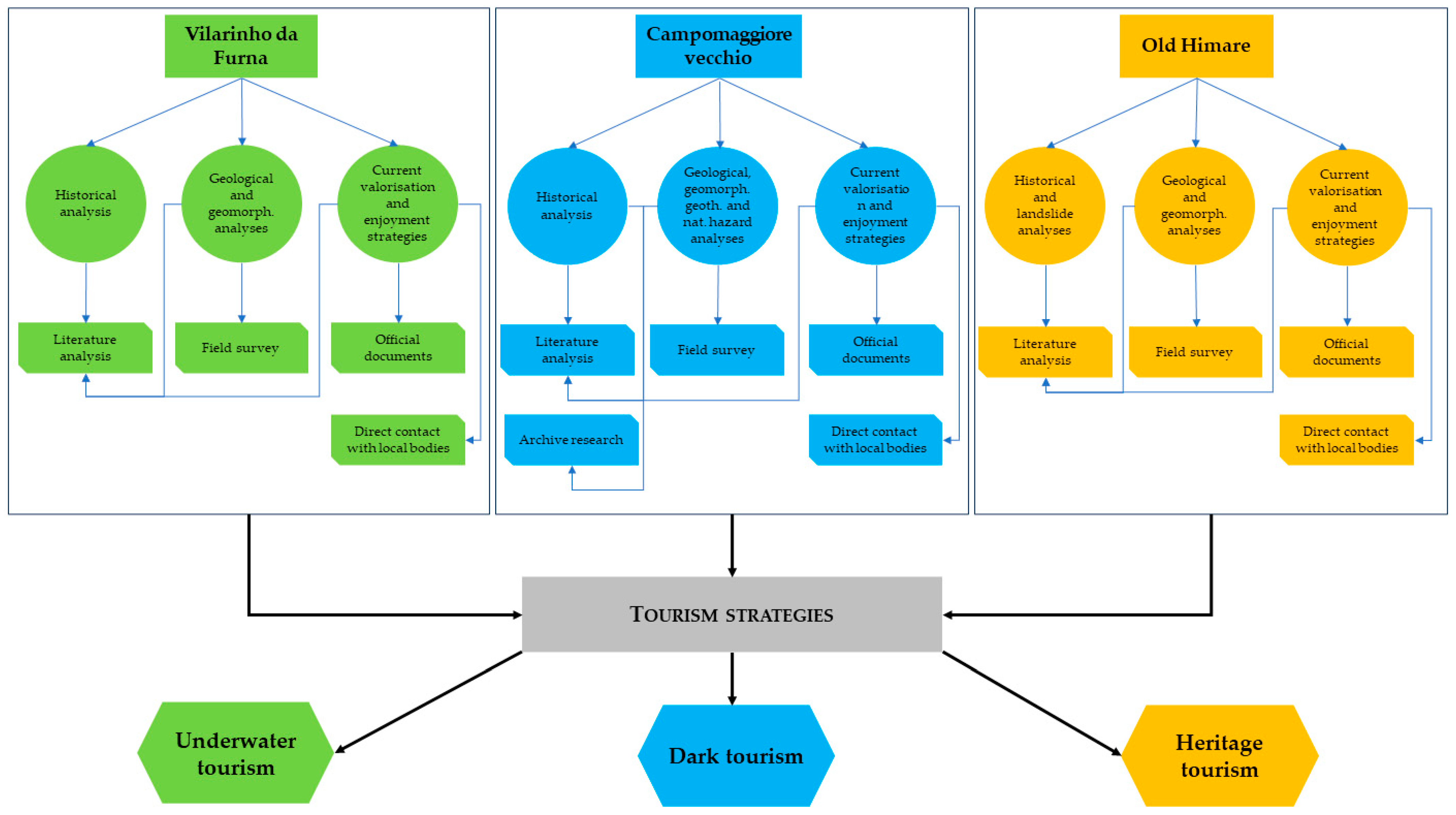
2. Materials and Methods

The investigation followed the methodology summarised in Figure 1. To obtain information on settlement histories of the three ghost towns, their geo-territorial features, and current valorisation and enjoyment strategies, we first conducted desk research to collect bibliographic and documentary (unpublished) data. This approach was important to achieve the aims we posed in the research, thus providing a roadmap for the additional research needed. We searched for published and unpublished data in both physical and digital libraries and archives. After this stage, we performed geological and geomorphological field surveys to draw up the related geothematic maps, which summarised the scientific data necessary to delve deeper into both the reasons for settlement abandonment and features of the territory in which the three sites are localised.
Local institutions were also contacted to obtain relevant information on current or future strategies to valorise and enjoy the three sites, namely, the Municipality of Terras de Bouro (Portugal), the Museu Etnográfico de Vilarinho da Furna (Portugal), the Municipality of Himare (Albania), and the Municipality of Campomaggiore vecchio (Italy). The involvement of stakeholders and policymakers is among the matchmaking activities envisaged by the BEGIN project, which also aims to provide technical assistance in defining strategies for protection, geoconservation, and enjoyment of the sites, with special attention to the use of innovative technologies. The engagement of stakeholders and local institutions was supported using formal and informal communication and dialogue tools such as meetings (in person and online), as well as other forms of communication, such as e-mails.

3. Results

The following subsections present the geographical, historical, and geological–geomorphological features of the abandoned settlements of Vilarinho da Furna (Portugal), Campomaggiore vecchio (Italy), and Old Himare (Albania) (Figure 2). Each case study is presented in a quite standardised way, considering both the historical background and geological–geomorphological settings as well as current valorisation and enjoyment strategies.

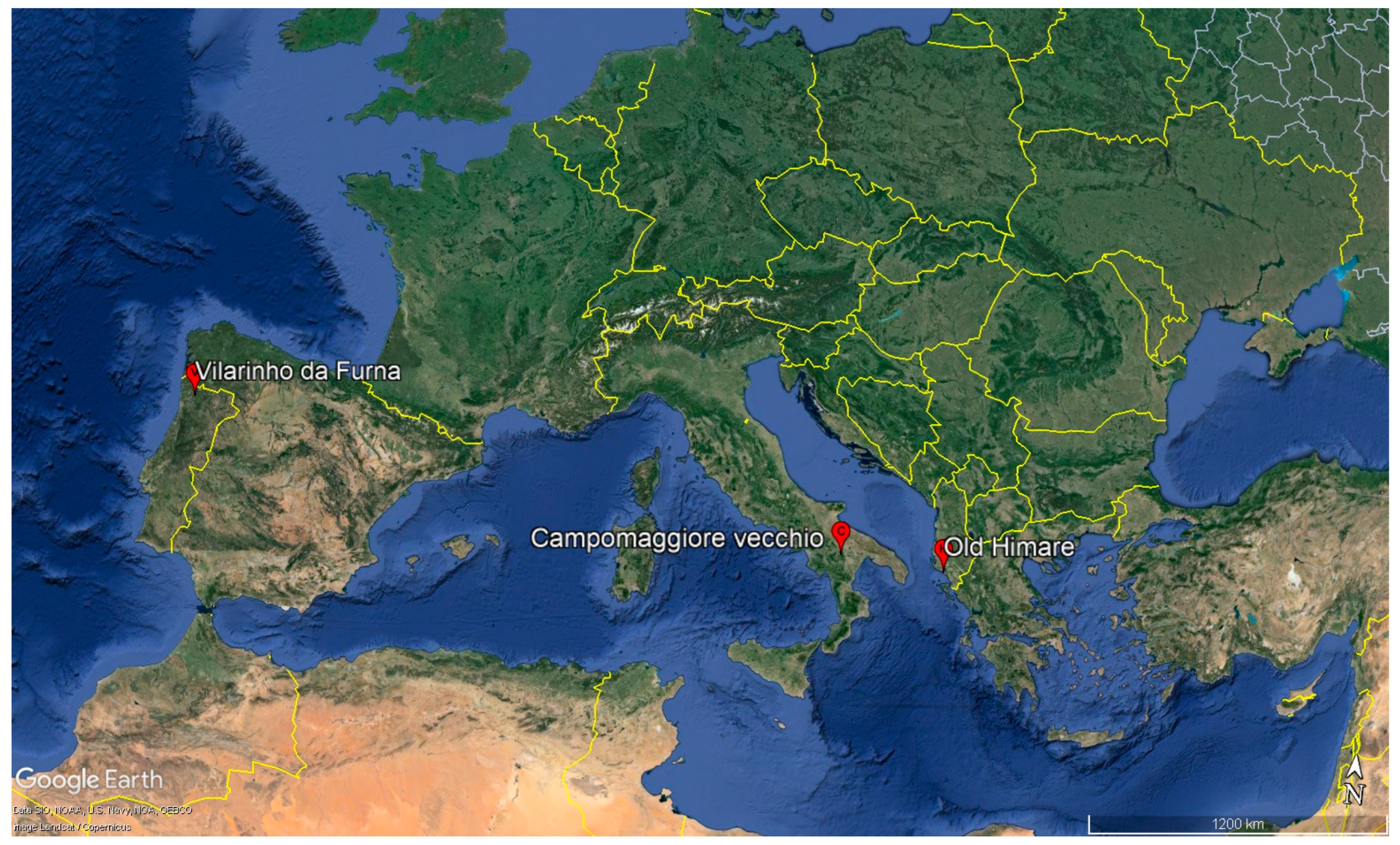
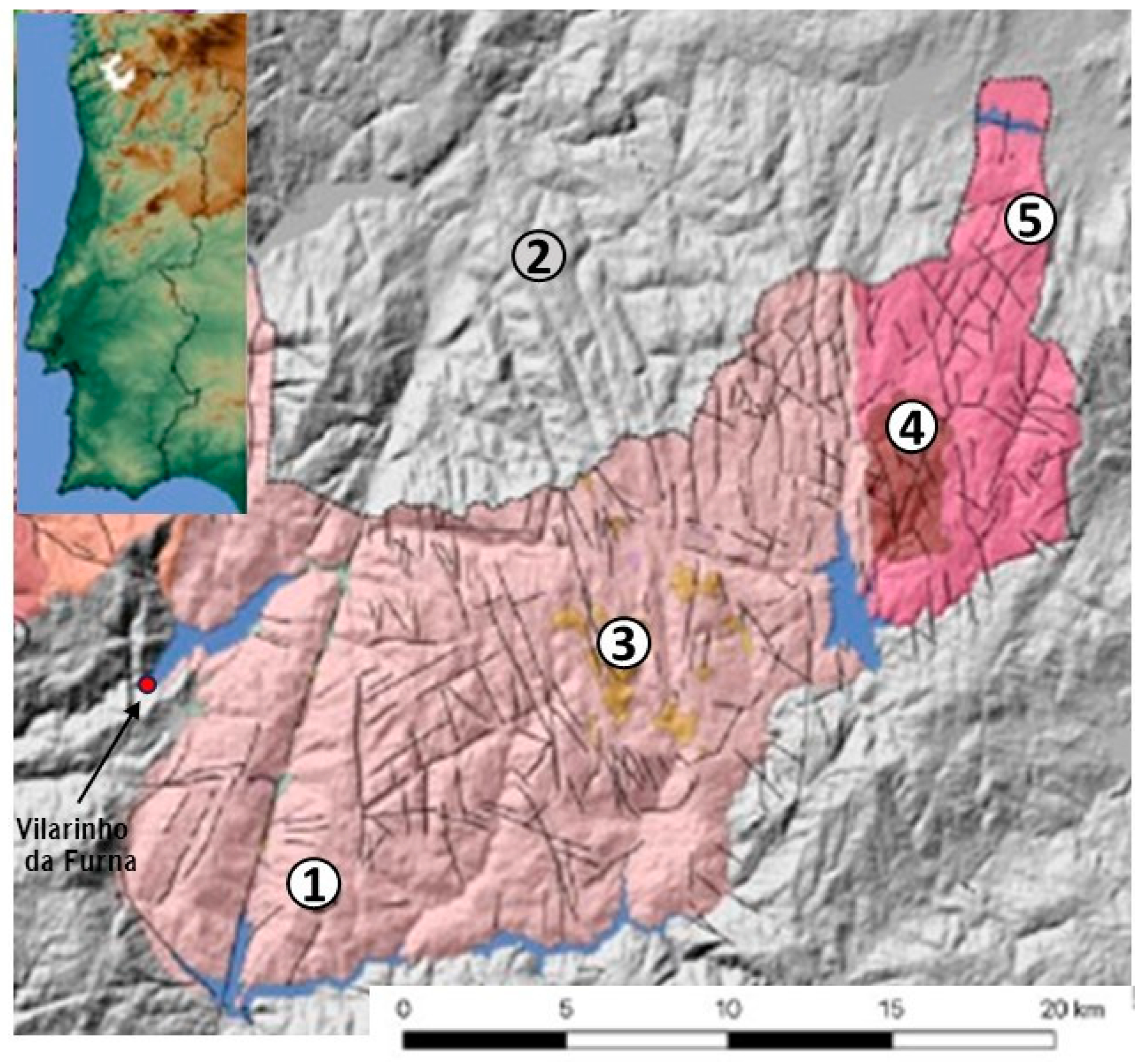
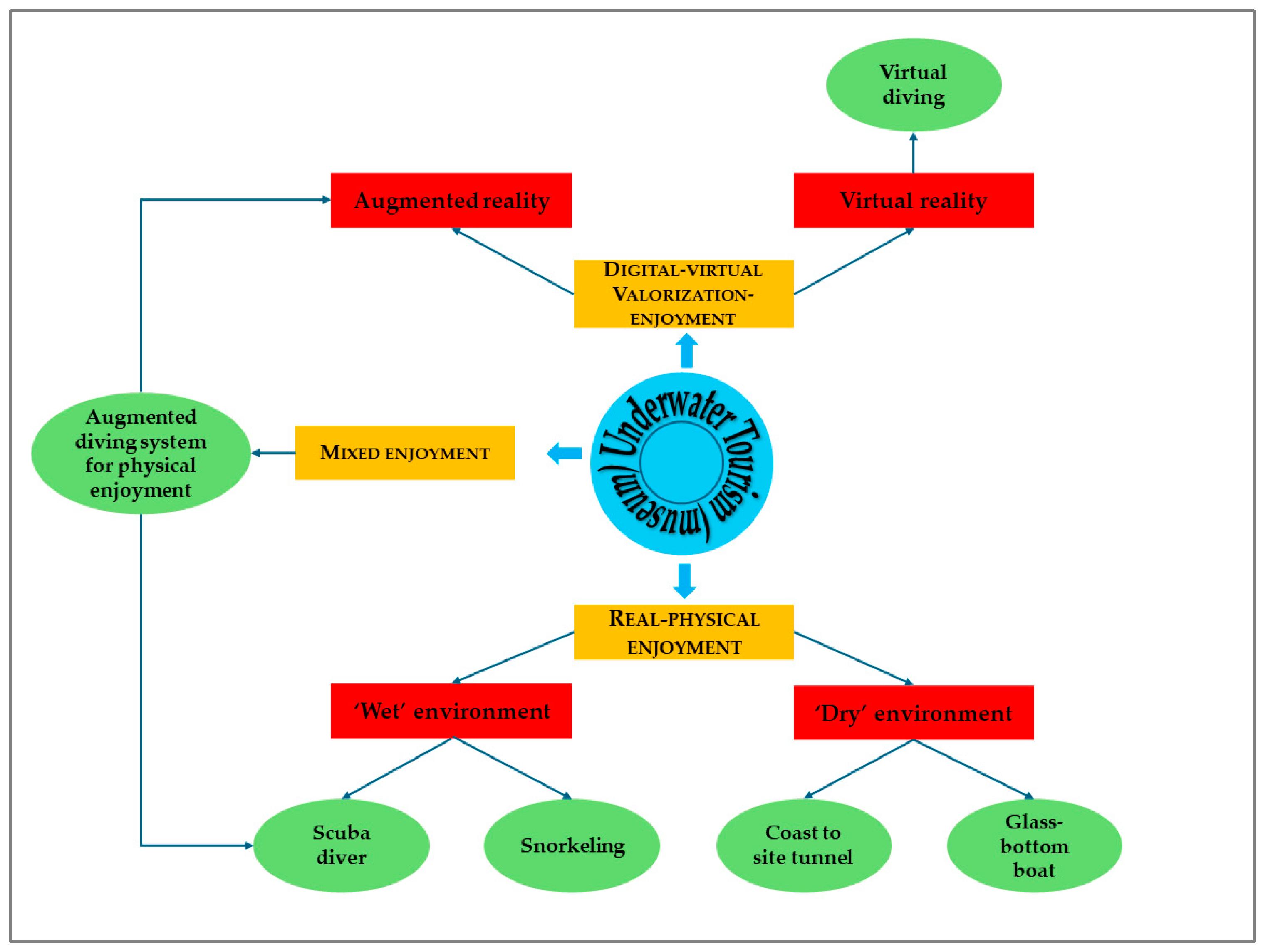
3.1. Vilarinho da Furna: The Underwater Village

3.1.1. Geographical and Historical Background

Vilarinho da Furna is a small village in the parish of São Joao do Campo, located in the northeast of the municipality of Terras de Bouro, in the Braga district, North-West Portugal (Lat. 41°46′46″, Long. N, 8°11′47″ O). The site is within the Peneda-Gerês National Park (PGNP), which is the only national park in Portugal and corresponds to the highest status for protected areas. The PGNP was established on 8 May 1971 by Decree-Law No. 187/71 [28].
The lifestyle in Vilarinho da Furna was influenced by the culture of the Indo-European shepherds and livestock farmers introduced by pre-Roman migrations. The village had a unique system of governance. It was led by a council called the ‘Junta’, which was composed of one member from each village family. Every six months, a married man was chosen as the leader of the ‘Junta’, receiving the title of ‘Zelador’ or ‘Juiz’. This system of governance was based on the Visigoths’ Conventus Publicus Vicinorum, which translates to Public Assembly of Neighbours [29]. This community character of the village was well supported by its governance and social organisation, directly related to the distribution/exploitation of the rural property managed by the ‘Junta’. In this assembly, issues involving the population were discussed, and relevant measures were considered (e.g., the reparation and construction of roads, organisation of pastoral strategies, distribution of irrigation water, and scheduling of harvests, among other local matters).
The village of Vilarinho da Furna was completely abandoned and flooded in 1972 due to the construction of the Vilarinho da Furna hydroelectric dam on the Homem River. In Portugal, the boost in hydroelectric power production came from the 1940s, regulated by Law No. 2002, from 1944, which defined the construction of the main Portuguese electric lines [30]. The first hydroelectric companies emerged with the goal of providing electricity to major cities, like Porto in the North of the country, through the Cávado River hydroelectric power station. From the 1950s onwards, the Electricidade de Portugal Enterprise (EDP) was responsible for the construction of large hydro and thermoelectric projects, notably in Vilarinho da Furna, which caused the submersion of the village. Although there were some protests, in 1971, the Portuguese electricity company persuaded the residents to evacuate their homes since the dam would completely flood the small village of about 300 people. One year later, the buildings were submerged, and more than 2000 years of history were lost underwater.
Between September 1969 and October 1970, due to the dam’s construction, about 270 inhabitants distributed by the 57 families [31] began to abandon their homes (Figure 3) and moved to the neighbouring districts of Braga and Viana do Castelo.
Although the Vilarinho da Furna heritage site has been significantly impacted by the dam, it still encompasses approximately 3000 hectares of land spread across the Serras da Amarela and Gêres, corresponding to community lands, currently transformed into the private property of the owners’ descendants. Furthermore, when the water level is low, the remnants of the buildings become visible in the landscape (Figure 4).

3.1.2. Territorial and Geological Settings

The area of the PGPN extends over about 709 km2, with remarkable natural and cultural features present in the Peneda, Amarela and Gêres Mountains close to the border with Spain (Figure 5). Most of the park’s territory rises 1000 m above sea level (a.s.l.), with the highest peaks about 1546 m a.s.l. (Serra do Gerês) and 1416 m a.s.l. (Serra da Peneda; Figure 5). These mountains correspond to the most western branch of the north-western Iberian Mountain ridges and part of the north-to-south orographic barrier that influences the high rainfall values, which are among the highest in Europe [32]. In the PGPN area, the mean total annual rainfall can be greater than 3000 mm [33].
The establishment of the PGPN as the country´s first protected area was a landmark in nature-conservation policies in Portugal, joined by the first national legislation for nature protection. These accomplishments resulted mostly from national and international demands to the Portuguese authorities during the celebration activities for the European Year of Nature Conservation in 1970.
The PGPN territory is mainly composed of granitic rocks that were emplaced in the continental crust at 320–290 Ma during the Variscan orogeny (Figure 6). During this geological period, sedimentary rocks of Silurian age (435–408 Ma) were deformed and metamorphosed and are represented by schists, metagraywackes, and quartzites, which occurred in the NW and SE sectors of the PGNP. Dykes and sills of basic rocks, quartz, and aplite-pegmatites crosscut the granites and the metamorphic rocks [34].
The most representative granitic rock in the PGNP is the Gêres pluton, a distinctive example of the late to post-orogenic plutons in the Iberian Palaeozoic Massif. U-Pb geochronological data indicate an emplacement age from 290 to 296 Ma [35], corresponding to the youngest granite in the PGNP area [36]. The pluton outcrops over an area of about 800 km2, across the border between Portugal and Spain, covering most of the mountains of the area. The Gêres granite (Figure 6) corresponds to a porphyritic, medium-to coarse-grained, slightly rose-coloured, biotite monzogranite. Inside the Gêres granite, irregular masses of fine-grained, slightly porphyritic biotite monzogranite occur and are referenced as Carris granite. On the east part of the pluton, the Parada granite (Figure 6) is characterised by a medium-grained two-mica granite, which passes through a coarse-grained nodular granite containing migmatites—Castro Laboreiro granite. Some of these granitic rocks have been affected by hydrothermal alteration and transformed into episyenites [36].
A dense fracture network, observable in units 1 and 4 of Figure 6, affects the rocks and is particularly visible at higher altitudes, where the granites crop out in sparsely vegetated terrain. The Senhora da Peneda and Lovios-Gêres NNE-SSW strike–slip faults cause the rivers to form deep, straight valleys in the same direction [34]. In the area, other rivers—Lima and Cávado—cross the PGPN in an ENE-WSW direction, while many secondary rivers follow NNW-SSE and N-S directions. The occurrence of hot springs is also related to these fault and fracture systems and mainly to those with an NNE-SSW alignment [37].

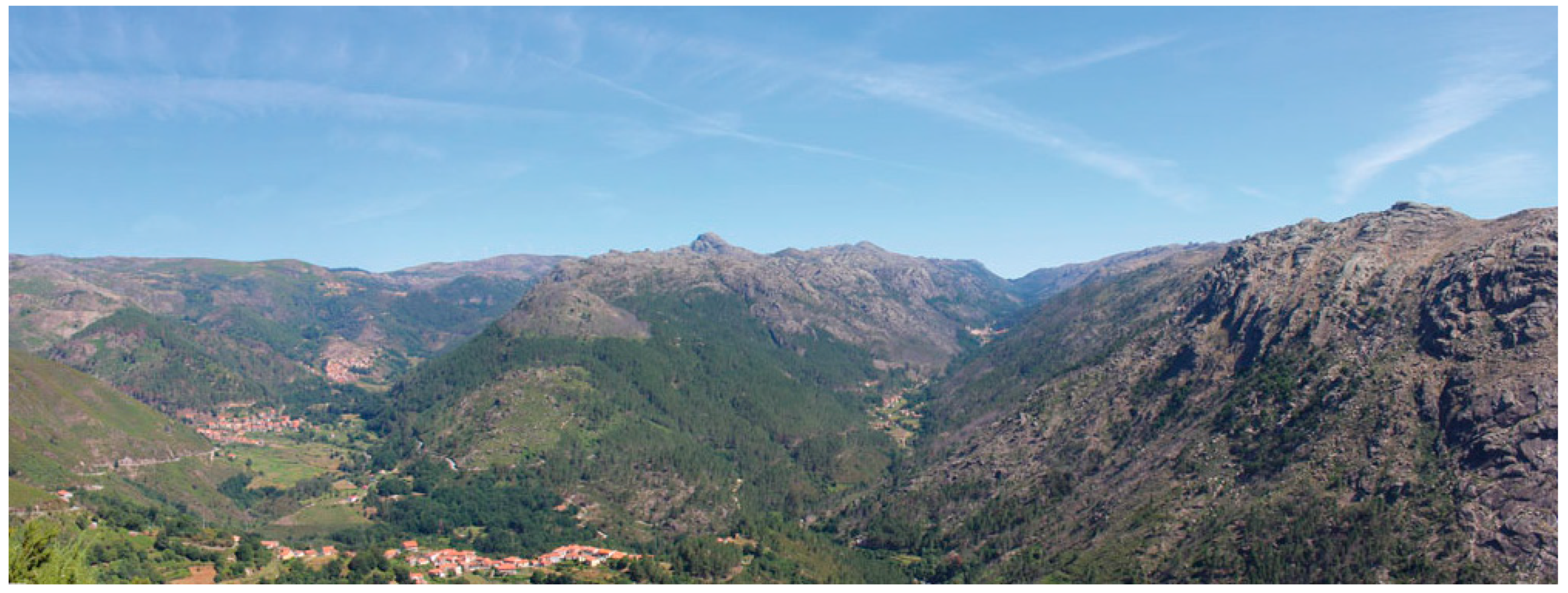
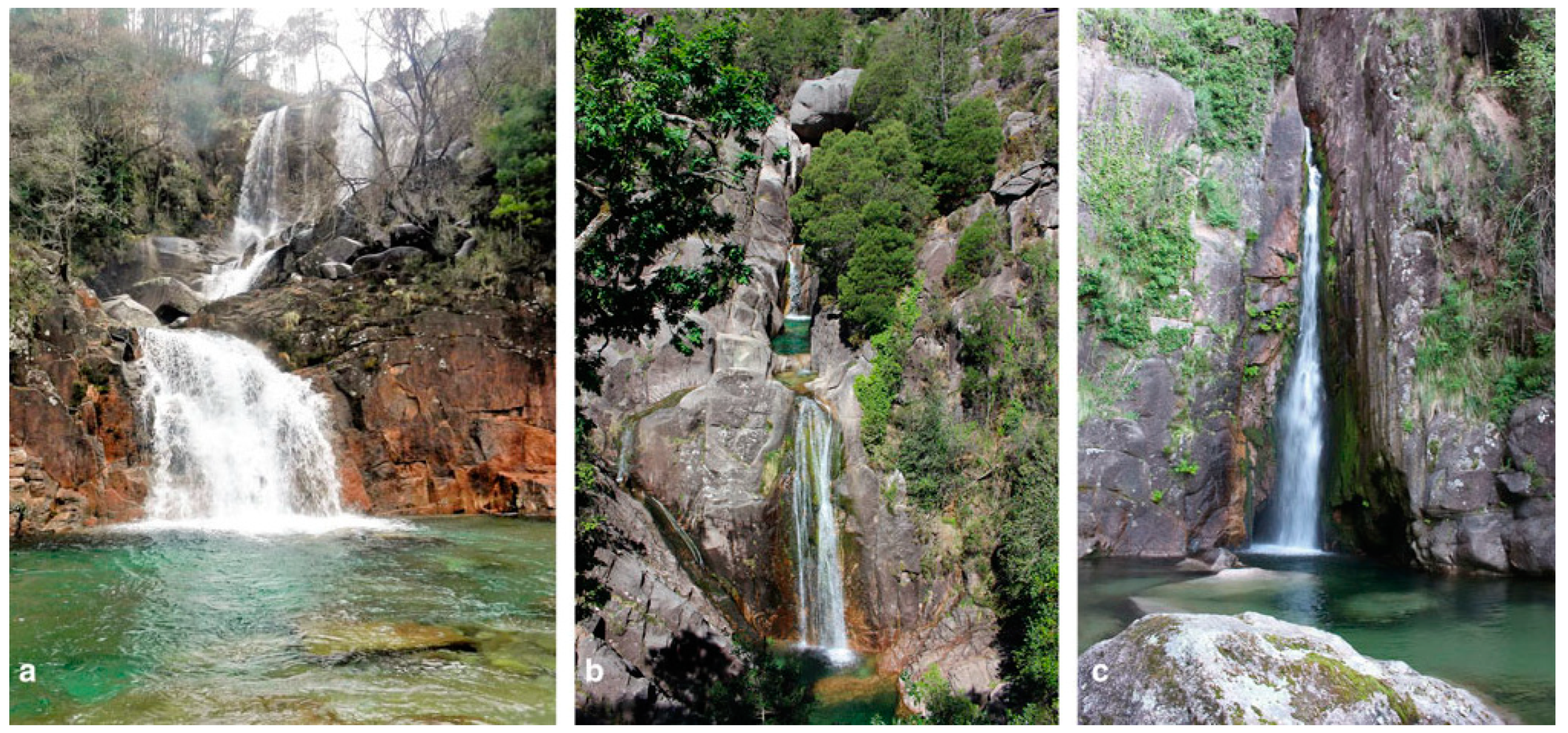
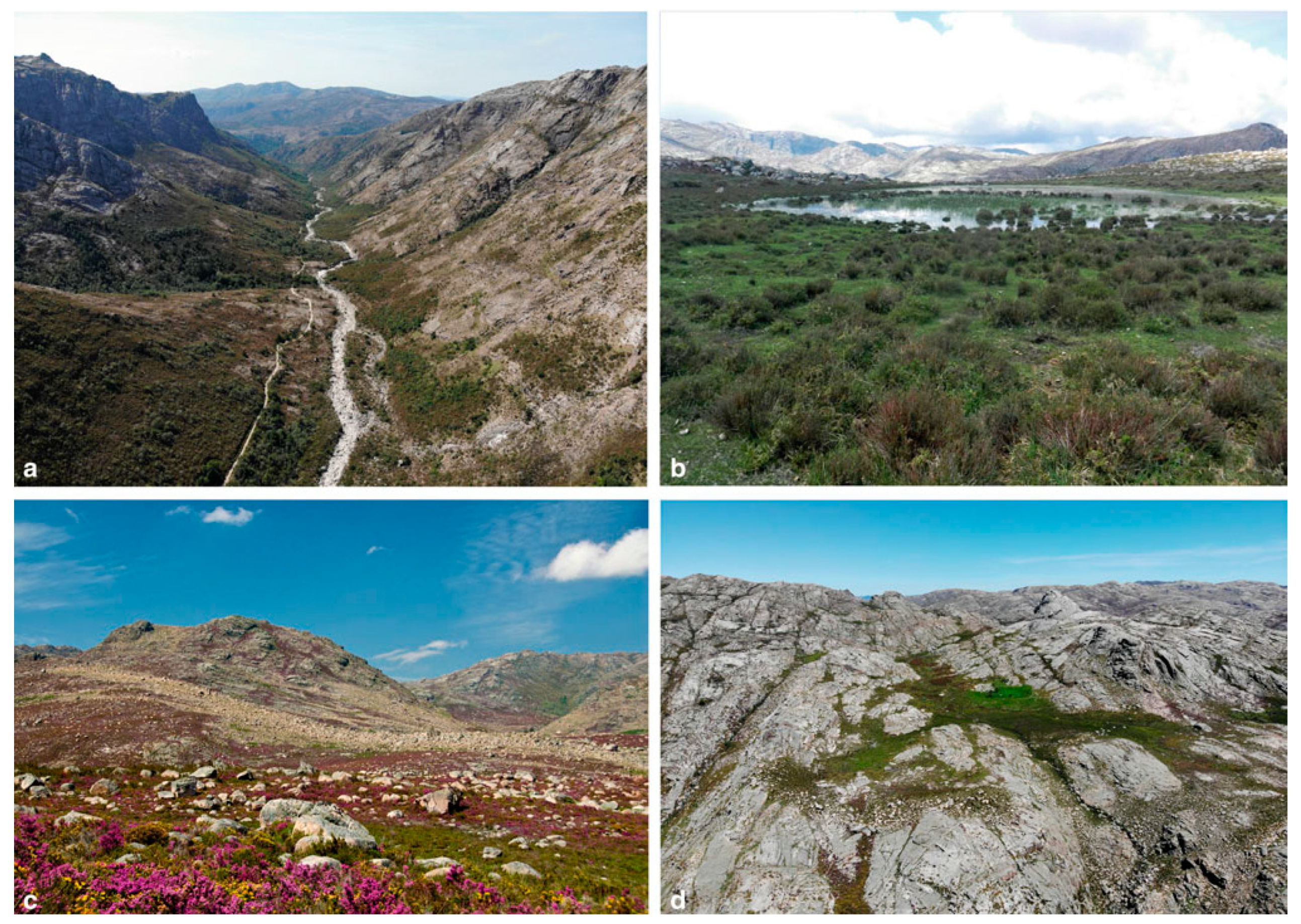
3.1.3. Geomorphological Setting

During the last phases of the Variscan orogeny, the fault and fracture systems were reactivated in response to compressive tectonic episodes that have affected the Iberian Peninsula since the end of the Cretaceous period. The mountains in the PGNP from the western branch of the Cantabrian Mountains were uplifted due to the European plate subducting under the Iberian Plate in the Bay of Biscay, which occurred throughout the Cenozoic. The presence of Paleogene and Neogene fluvial sediments in Northern Iberia provides evidence of the tectonic stages of this earlier uplift [38].
In the Eocene, intense tectonic movements formed a series of uplifted blocks and basins, reactivated during the Late Cenozoic period, since the Middle Tortonian, under the influence of an NNW-SSE to NW-SE-oriented compression [39]. The PGNP region has experienced vertical uplift of 200 to 500 m over the last 3 million years, resulting in the formation of deep valleys and rugged relief due to geological and tectonic factors [34,40]. These features, which constitute one of the main elements of the landscape, are related to the occurrence of the Gêres granite (Figure 7).
The steep gradient between the highest levels and the deepest valley floors justifies the occurrence of waterfalls forming the well-known landmarks of the PGNP (Figure 8). These waterfalls are generally small, ranging from 5 to 30 m in height, and mostly occur on the southern slopes of the Serra da Gêres, where small tributary streams rapidly fall from the highest levels to the bottom of the deep Cávado river valley [41].
Despite the irregular morphology, a few planation surfaces persist in the eastern and north parts of the PGNP, corresponding to the Castro Laboreiro granite (Figure 6; approx. 1250–1300 m a.s.l.). Plantation levels at PGNP are relatively scarce, poorly preserved, and discontinuous, with the most elevated ones located between 1400 and 1450 m a.s.l. in Gêres and between 1250 and 1300 m a.s.l. at Peneda [42]. Nevertheless, the contrast between the interfluves and the steep slopes of the valleys makes the summits look planar. Below the highest summits, the planation levels are generally unclear, with the lowest ones at altitudes of approximately 500 m a.s.l. [43].
The first reference to glacial evidence in the north-western mountains of Portugal dates from the late 19th century, but it was only in the 1950s that cirques, U-shaped valleys (Figure 9a), lakes (Figure 9b), and moraines (Figure 9c,d) in the Serra do Gêres summits were identified as glacial landforms [44,45]. Currently, it is demonstrated that during the Late Pleistocene, the PGNP mountains were covered by a plateau ice field, like that of the Serra da Estrela in Central Portugal or in the Galician and Leonese Mountains [34]. In the PGNP, the Pleistocene snow line is inferred as 1000 m a.s.l., and this low-altitude glaciation has great significance in paleoclimatic episodes in the Southern Europe and Mediterranean glaciation contexts [46].
The moraines mostly correspond to simple alignments of rounded boulders in interfluve positions or along slopes and valleys (Figure 9c). The Homem River upper valley is one of the best areas to observe the glacial processes that shaped the mountains. The upper valley is U-shaped (Figure 9a) and straight for about 4 km, showing abundant traces of glacial processes. However, due to the steep slopes, moraines did not persist in their original position after the glaciation. The valley floor is filled with fluvioglacial deposits, and some moraines above the slopes indicate that the Homem glacier was about 300 m thick [34].
The area landscape is dominated by granite megaforms, mainly those in the Gêres granite facies, characterised by a distinctive rugged relief. The scarce vegetation cover in the higher mountains highlights the landforms and reveals lithologic and tectonic controls on the landscape. Major landforms, such as valleys and residual hills, were shaped in response to the uplifting of the mountains and the carving of the rivers since the Early Cenozoic period. Glacial and periglacial activity during the Late Pleistocene period also played a role in shaping the higher mountain areas. Interestingly, even smaller granite landforms seem to predate the glaciation period, as they are fully developed only in non-glaciation areas [34].
The aesthetic value of landforms of the PGNP has been recognised as one of the main reasons for the ‘wilderness’ character that supported the creation of this protected area and is responsible for its growing attractiveness to tourists. Moreover, the high scientific value of some of the granite and glacial landforms found on the PGNP is the main cause of their classification as geosites of national relevance and inclusion in the Portuguese inventory of geological heritage under the ‘Iberian Massif landscape and fluvial networks’ and ‘Vestiges of the Pleistocene glaciation’ frameworks [47,48,49].

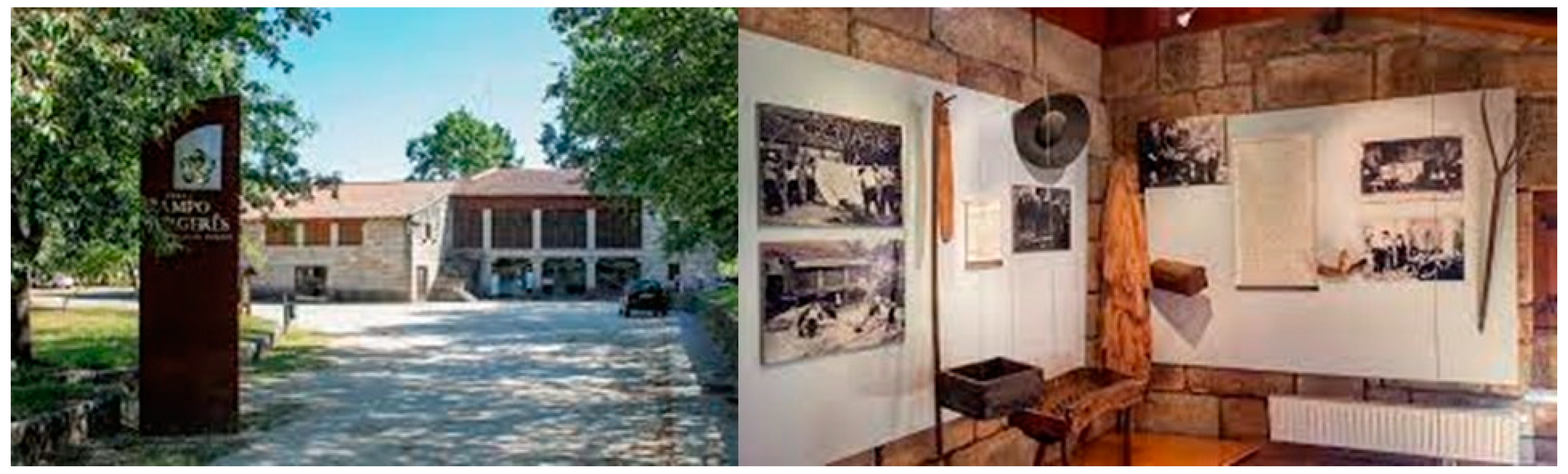
3.1.4. Current Valorisation and Enjoyment

The local heritage is of great historical and cultural significance, in addition to the obvious socioeconomic aspects. It is preserved and exhibited at the Ethnographic Museum of Vilarinho da Furna (Figure 10). Indeed, at the end of 1968, the former inhabitants of the village gathered with the purpose of achieving a single goal: to collect the village’s ethnographic heritage and preserve it. This ethnographic heritage represents the agriculture sector, community traditions, domestic life, and the genuine rurality of the lives of the village’s inhabitants. The Ethnographic Museum then arose from the common desire of Vilarinho da Furna displaced people, with the purpose of preserving the collected assets. In 1981, the Municipal Council of Terras de Bouro began the construction of the museum, using raw materials brought from the old village, which opened on 14 May 1989 (Figure 10). The Ethnographic Museum of Vilarinho da Furna was built with the original stones from the community village and currently stands as an important centre of history and culture [50]: between 2022 and 2023, the museum welcomed approximately 16,000 visitors, with 63% being Portuguese and 27% coming from abroad [51,52].
In October 1985, the former residents of Vilarinho da Furna founded an organisation entitled ‘Furna—Association of Former Inhabitants of Vilarinho da Furna’ with the purpose of preserving, valuing, and promoting the community heritage and culture. This heritage is fundamentally composed of historical–cultural and socio-economic components, allowing the creation of a regional and national development hub [53].
Currently, the main concern of the former inhabitants of Vilarinho da Furna is the full use of this heritage, which includes the reforestation of the lands located in Serra Amarela and Gêres, the creation of a protected area for local wildlife, and the development of touristic activities that preserve and promote the existing ecological heritage.
In 2008, the municipality of Terras de Bouro, to which Vilarinho da Furna belongs, approved the project Valorização do Espaço Natural da Serra da Amarela. This project is based on the establishment of the Parque Natural de Vilarinho da Furna, which also includes a glass-bottom boat to observe the underwater remains, wildlife observation places, pedestrian trail, mountain shelters, solar energy installations to make the park energy self-sufficient, and the construction of the Vilarinho da Furna Interpretative Centre [54]. To date, some actions of the park project have been developed, namely, the pedestrian trail and the Interpretative Centre [55].

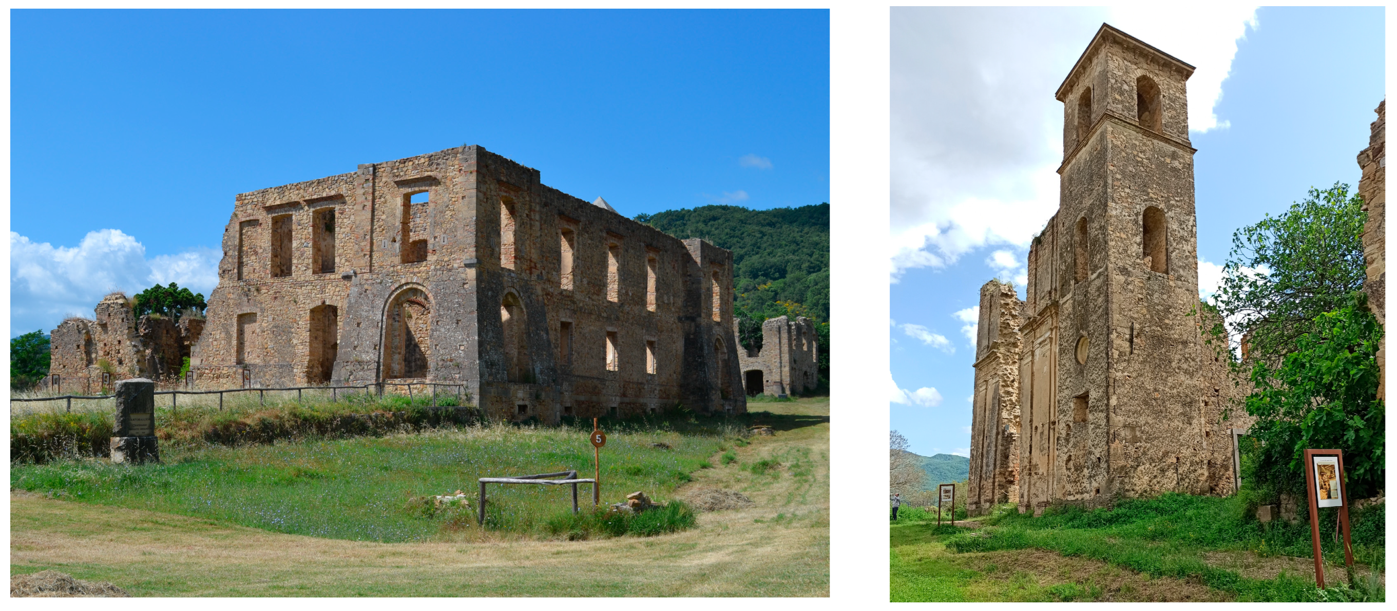
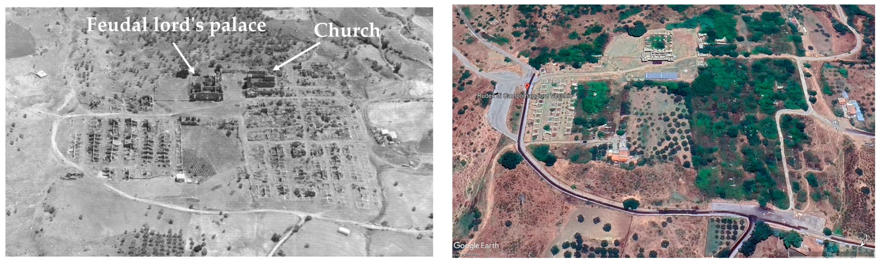
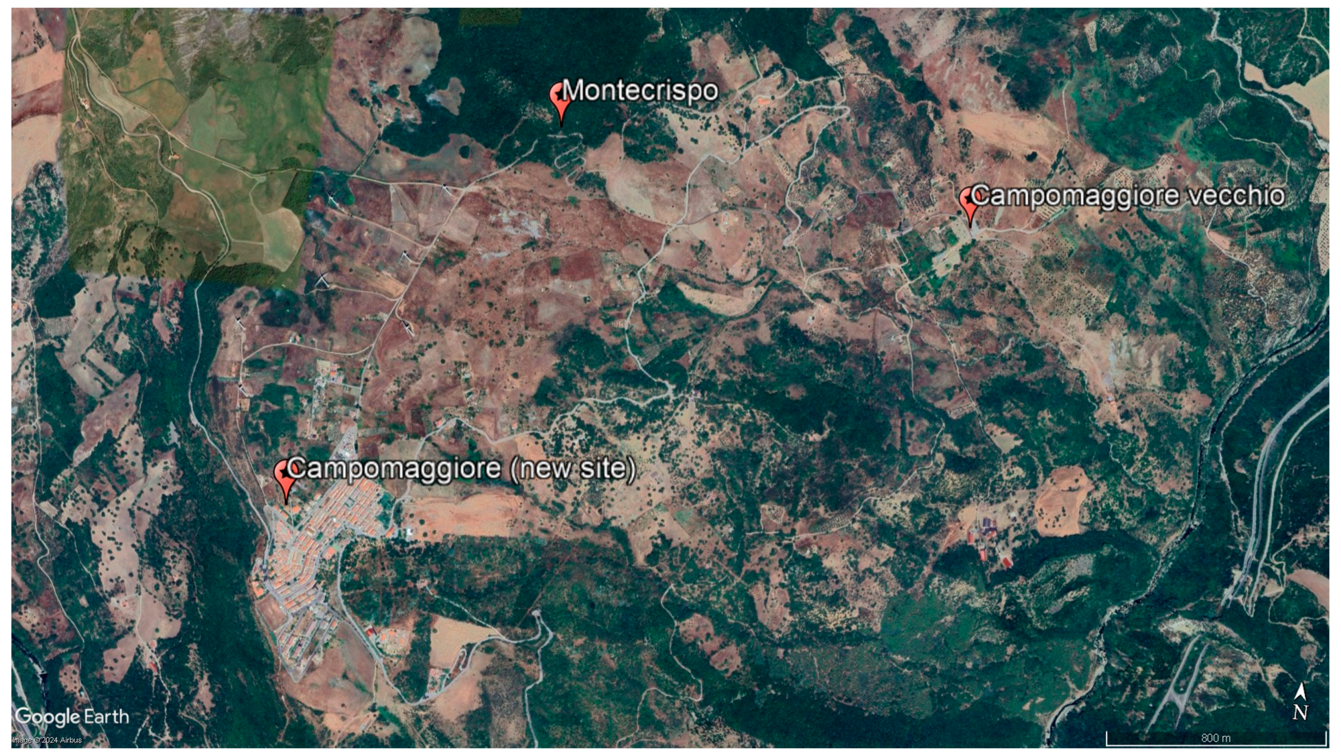
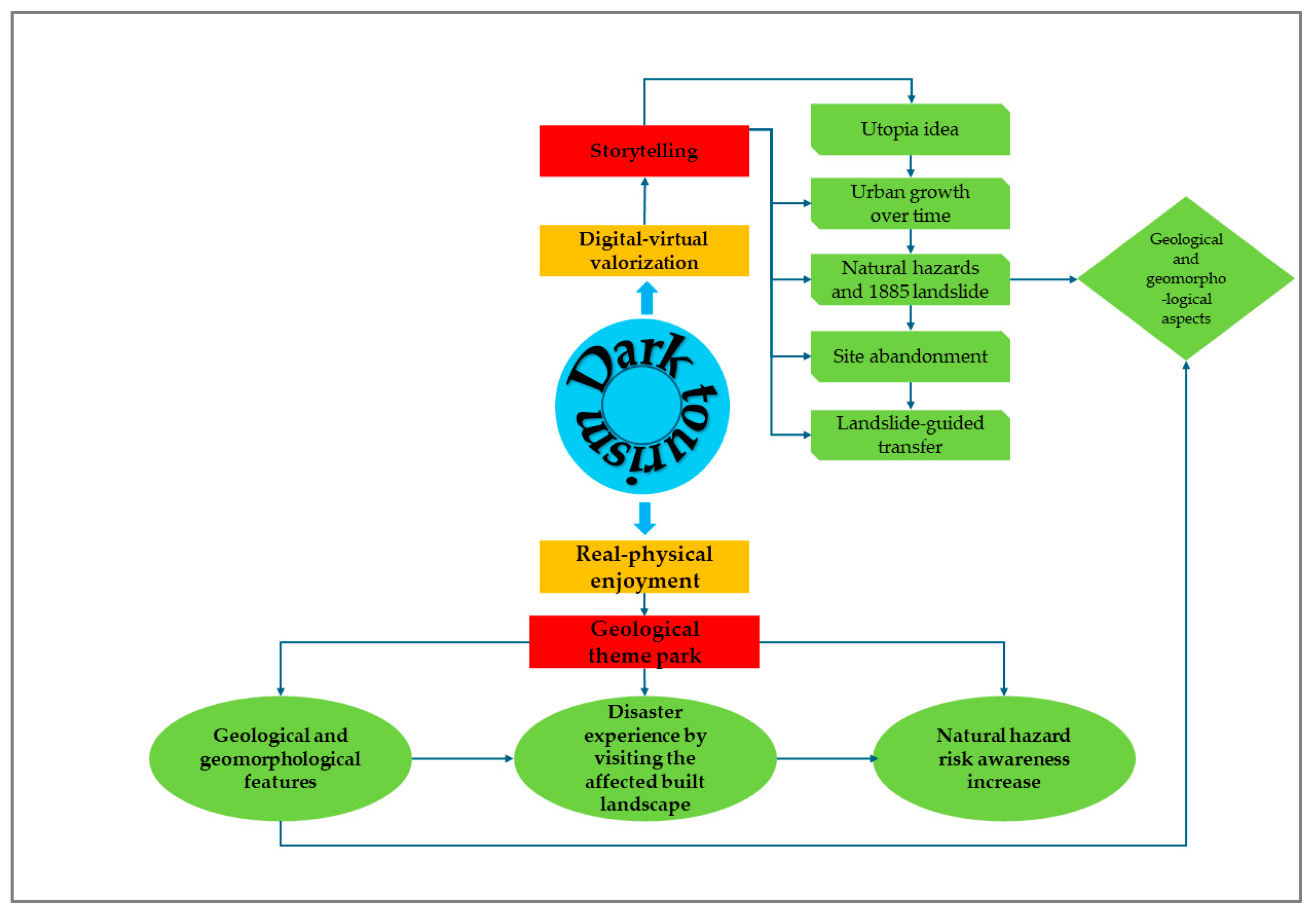
3.2. Campomaggiore Vecchio: The Double Abandonment

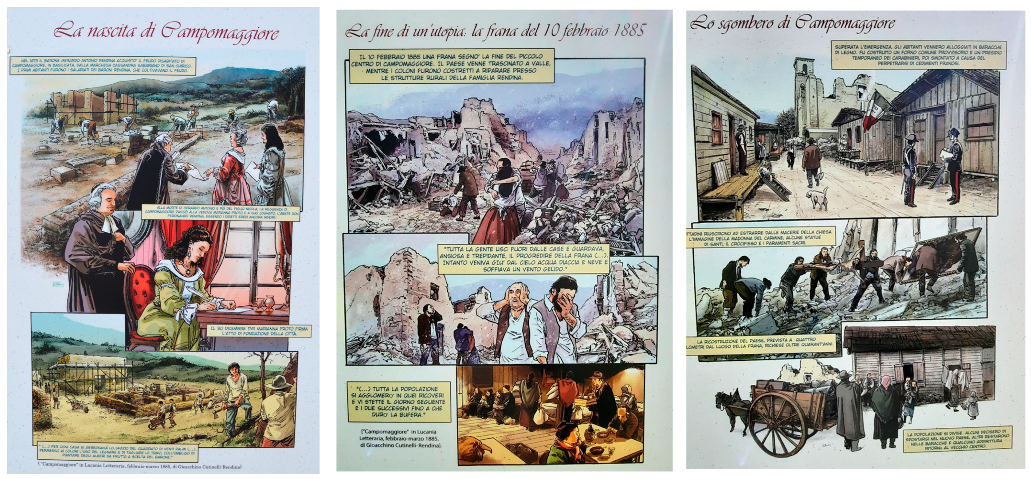
3.2.1. Geographical and Historical Background

The abandoned village (Lat. 40°34′41″ N, Long. 16°5′53″ E) is in the Basilicata region (Southern Italy), a natural and human-built laboratory [56,57,58], about 20 km east of its chief town (Potenza). The site, whose toponym derives from Campum Maiorem, with the meaning of an excellent land cultivated with wheat, has very ancient origins, as can be argued from the discovery of tombs dating back to the third century BC found locally [59,60,61,62].
After a prosperous economic period in the Norman–Swabian period, the settlement suffered a socio-economic decline, which, due to famines and plagues, was completely abandoned. In 1673, Gerardo Antonio Rendina acquired the fiefdom after his father, Carlo Rendina, received the title of count from Philip IV of Spain, with the prescription to repopulate it [60]. In 1741, the year of its foundation, the fiefdom had around 80 inhabitants, and in 1768, it was inherited by Giuseppe Rendina, whose son, Teodoro, appointed count of Campomaggiore in 1797, was a decisive personality in the history of the site as he brought about an effective change socio-economic–cultural situation. Teodoro decided to draw up a pioneering project, the Città dell’Utopia (City of Utopia). It was an authentic social experiment implemented by Count Teodoro Rendina, following the principles of equality, justice, and collectivisation of economic resources of utopian socialism (Charles Fourier, 1772–1837; Robert Owen, 1771–1858). The project materialised with the issuing of an edict focused on the granting of accommodation to all those who would have moved permanently to Campomaggiore. The project was based on three main ideas: (1) a regular urban checkerboard layout; (2) homes with the same dimensions and technical–structural characteristics; (3) the presence of public utility services (e.g., a mill, wash house, and municipal cemetery) [60,61,62]. Teodoro planned reclamation works for the marshy areas and a precise and organic urban planning study with the support of the architect Giovanni Patturelli, collaborator of Francesco Collecini, first assistant of the eminent architect Luigi Vanvitelli (1700–1773), who planned the Royal Palace of Caserta, today a UNESCO heritage site. A regular chessboard layout was created, and the two main structures of the political and religious life of the site were placed around the main square: the feudal lord’s palace and the church [63] (Figure 11).
Figure 11. Campomaggiore vecchio. On the left: the feudal lord’s palace; on the right: the church (see Figure 12). Taken from F.T.G. (2023).
Heritage 07 00183 g011
Figure 12. Aerial view of Campomaggiore vecchio: on the left: the photo taken in 1966, about eighty years after the giant landslide1; on the right: the same view taken in 2024 (source: Google Earth™).
Heritage 07 00183 g012
Finally, the houses, designed with the same size and with the same technical and structural characteristics, were equipped with a space intended for animals and a piece of land to be cultivated as an olive grove or vineyard. Teodoro also brought notable changes in agricultural processing techniques, bringing wheat seeds from Sicily and introducing new species of farm animals [60,61,62]. In 1816, the year in which Campomaggiore became an autonomous municipality, the inhabitants numbered 1000, which increased to 1300 in 18222 [60,62]. Furthermore, an edict was also issued, which ensured accommodation with agricultural land to cultivate for all those who moved permanently to the site. This led to a further increase in the population, which reached 1500 people in 1833, the year of Teodoro’s death. He was succeeded by Giuseppe, who carried out the planning of various public and private works, which were abruptly interrupted due to a landslide that hit the site in 1838 [62]. In 1845, Campomaggiore enjoyed the most important services: it was equipped with a railway station, an armed forces command, a cemetery consecrated in 1841, a fountain to be used as a public washhouse, and several oil mills distributed throughout the municipal territory. In 1853, a public school was also built, and the cotton and wool manufacturing industry began to develop.

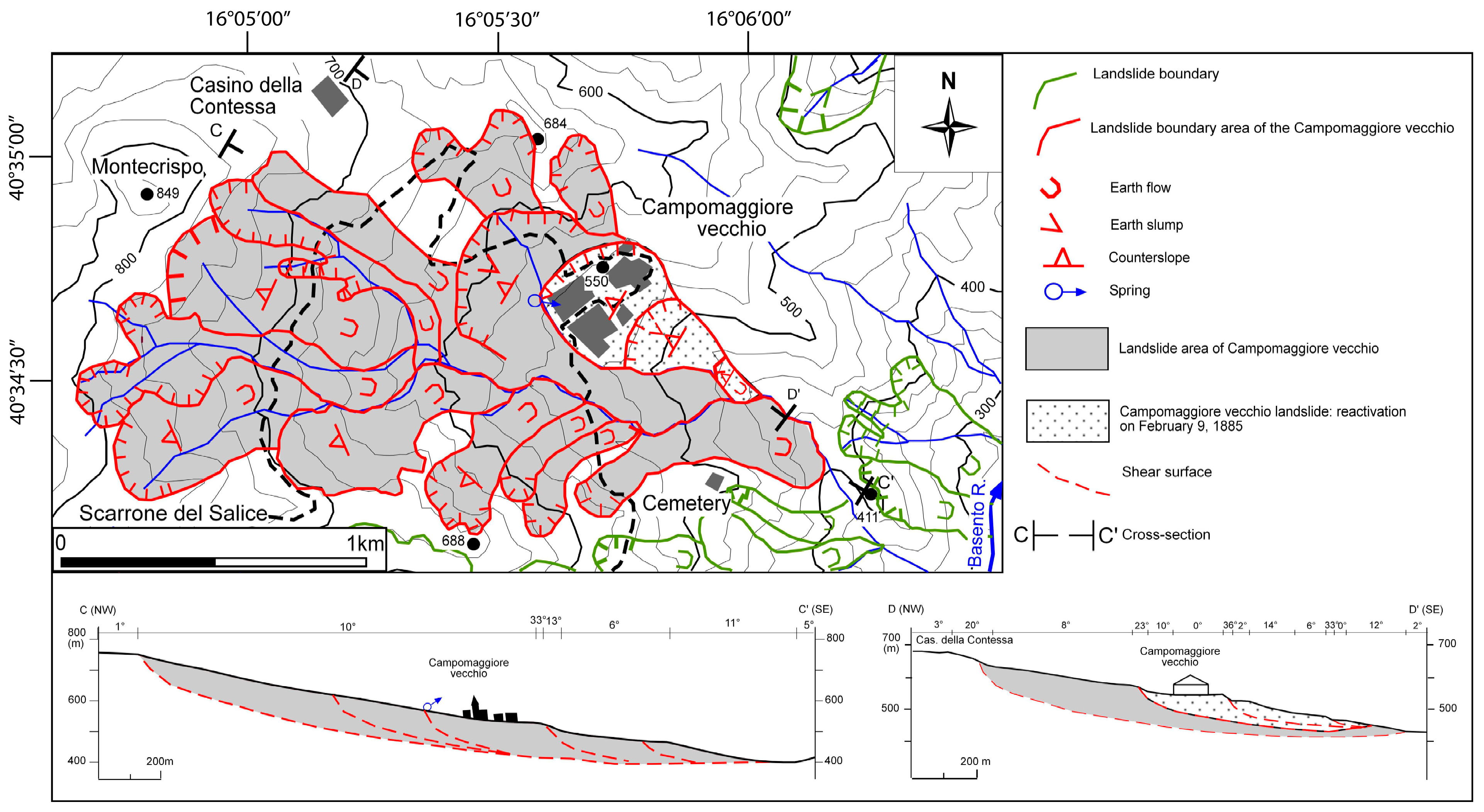
3.2.2. The (Last) Abandonment of the Village: The 1885 Landslide

The village, located in a region prone to earthquakes and landslides [64,65], suffered many heavy consequences due to natural hazards such as the earthquake of 1846 (local macroseismic intensity VI-VII MCS scale [66]). In fact, Ducci [67] reports that ‘On 8 and 9 August 1846, very strong seismic shocks occurred in Campomaggiore vecchio which produced openings in the walls of almost all the houses’ (our translation from Italian). Furthermore, Campomaggiore suffered the consequences of the earthquake of 16 December 1857 (local intensity VII MCS scale), which caused damage to eleven houses, while ten years later, the town was hit by cholera, and the area was subject to several landslides in the 1870s3,4 [67]. However, it was the massive landslide of 1885 that caused the definitive abandonment of Campomaggiore and its transfer to another site about three kilometres away (Figure 12).
The first indications of the landslide’s trigger date back to 8–9 February 1885, when the soil movements caused damage in several buildings and creaking in their wooden structures. On the 10 February, in the afternoon, the landslide accelerated, and since that moment, all the inhabitants abandoned the site; on the consecutive night and on the 11–13 February, the landslide movement, affecting an area of approximately 10 km2, continued, reaching a total horizontal displacement of about 18 m [67,68]. On 14–16 February, the landslide was almost inactive, probably due to the drop-in temperature below zero and the reduction in rainfall, which was very abundant in the days preceding the reactivation of the landslide. Once this meteorological phase had passed, the activity of the landslide continued for a few days [68]. As a result of the landslide, the entire village, inhabited by over 1500 people, was heavily damaged. The landslide caused very serious failures to the buildings, with total or partial collapses and serious injuries such as making the buildings unsafe [69,70]. The cause of the landslide was attributed to abundant rainfall, although the seismic tremors that affected the area in those days were hypothesised as a contributing cause. In fact, De Rossi reports that: ‘...on day 10 in which the maximum movement occurred, it also coincided in the hour with the maximum earthquake of those days...’ (our translation from Italian) [70].

3.2.3. The Transfer of the Village

There were two areas first selected for the transfer of the village. However, to ensure the stability of the soil and, above all, an abundance of water, the current area was preferred (Figure 13). The decision was taken in contrast with the will of the population who preferred another zone (Montecrispo, Figure 13), located one kilometre away from the old settlement and close to the land owned by the inhabitants. However, on 13 August 1885, the municipal council established that the Campomaggiore had to be transferred to its current location, following the General Town Plan that was drawn up in 1886.
The new town was designed following the urban and architectural rationale of the abandoned town, with wide streets parallel to each other, a central square which overlooked the church, and a multipurpose building (home to the town hall, school, and post office). Furthermore, 140 houses of 25 m2 were built and handed over to the community in August 1899 [60]. Giuseppe Zanardelli, President of the Council of Ministers of the Kingdom of Italy (1901–1903), made a trip to Basilicata in September 1902, and it was decisive for the definitive reconstruction of the town. Following this trip, Special Law No. 140 was issued on 23 March 1904. In the law, a specific article was dedicated to Campomaggiore to identify the rules for completing the reconstruction.

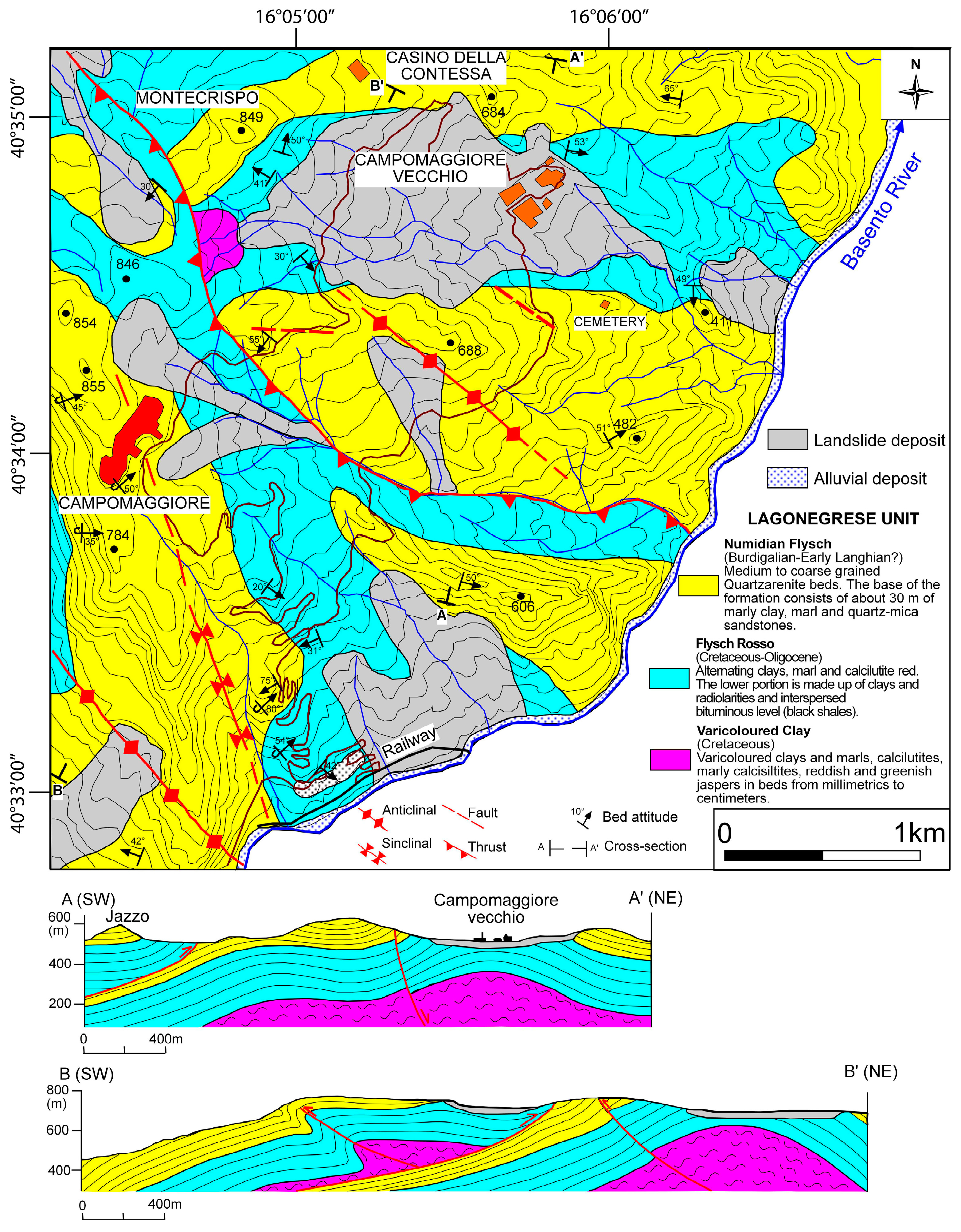
3.2.4. Geological Background

The study area is located along the eastern portion of the Southern Apennine Chain, in a sector adjacent to the Bradano Foredeep area. In this sector, the outcropping deposits are ascribed to the Lagonegro, Sannio, and Quaternary units [71].
The Lagonegro units are represented by Mesozoic to Cenozoic deep seawater successions, tectonically included between the Apennine Platform and the Apulia Platform carbonates [72,73]. They are divided into two stacked tectonic units emplaced during the Miocene contractional tectonic stages leading to the building of Southern Apennines [71,74,75,76,77,78]. The lowermost unit, the Lagonegro I Unit, shows the Calcari con Selce Formation at the base and is followed upward by the Scisti Silicei and Galestri formations. The uppermost Lagonegro II Unit consists of a succession like the Lagonegro I, but showing the Monte Facito Formation at the base and the Flysch Rosso Formation at the top.
The Sannio Units consist of a Cenozoic succession, originally deposited at the top of the Lagonegro I but currently detached from its Mesozoic bedrock [79]. In the Campomaggiore vecchio and the nearby areas, the succession (Figure 14) consists of the following formations: Argille Varicolori (Upper Cretaceous–Oligocene [73]), Flysch Rosso (Late Cretaceous–Oligocene), Tufiti di Tusa Formation (Oligocene–Lower Miocene [73]), and Numidian Flysch Formation (Lower Miocene [80]).
Based on the geological survey carried out in the study area, a strong deformation affecting the outcropping succession was detected. We recognised two different tectonic phases. The first phase is represented by compressional structures, such as thrusts and folds, linked to the building of the Apennine chain during the Lower Miocene–Lower Pleistocene. The main structure is represented by an extended, NW-SE-oriented thrust, located in the correspondence of the incision that separates the current town of Campomaggiore from the old settlement, which superimposes the Flysch Rosso onto the Numidian Flysch. This structure can probably be associated with a backthrust previously recognised in correspondence of the Campomaggiore town [76]. A series of large- and small-scale folds, observable both at the hangingwall and the footwall of the thrust, were documented and mapped.
The second tectonic phase is easily observable in the sandstones forming the Numidian Flysch and is represented by N 140°-oriented normal faults (Middle–Upper Pleistocene) overprinting the previously described contractional structures.
The Campomaggiore vecchio site is in correspondence with a large anticline showing a completely deformed core where deposits referred to the Flysch Rosso Formation crop out. This geological structure has certainly constituted an important predisposing factor to the subsequent development of the landslide that led to the complete abandonment of the inhabited centre.

3.2.5. Geomorphological Setting

The study area is in the middle–left slope valley of the Basento River. The area is characterised by abrupt changes in slope in correspondence with lithological changes. The altitudes of the study area are mountain and hill since the maximum altitude is 855 m a.s.l. and the minimum 270 m a.s.l. The physical landscape of the area is the result of complex morphogenetic dynamics, mainly influenced by old, recent, and present-day landslides varying in types and sizes. Due to the tectonic activity, the quartz arenite rocks of the Numidian Flysch are strongly fractured and therefore are subject to collapses and overturns. The collapses were detected in the southern part of the area, where it is also possible to observe the downstream accumulation of blocks and along the road (S.P. No. 13) connecting the S.S. No. 407 Basentana (high Basentana) with the present-day town of Campomaggiore. Overturns are more frequent along the topographical highlands as the locality Scarrone del Salice (Figure 15). The spatial density of landslides increases where there is a dominantly clayey outcrop. These areas are affected by different types of landslides, such as earth flows and complex movements. On the one hand, the complex landslides detected in the upstream area are characterised by morphologies attributable to rotational slides; on the other hand, in the downstream area, the landslide body lengthens and then, at times, fans out in the terminal part (earth flow) [81]. Often, in the upstream part of these landslides, there are wetlands areas corresponding to landslide terraces. Shallow gravitational movements were frequently detected along the clayey slopes and were highlighted in places with an irregular growth of trees (inclined towards the valley), mostly attributable to solifluction.
The hydrography is characterised by a series of water courses from NW to SE towards the Basento River. All water courses have a well-developed dendritic pattern in the initial part, while the final one assumes a dominant direction. In the upstream area, the channels are small and a bit engraved, whereas those from the middle–lower part of the slopes to the confluence in the Basento River are well-cashed.

The Landslide of Campomaggiore Vecchio

The large landslide area of Campomaggiore vecchio affects the left slope of the Basento River, and it extends to the Montecrispo site from 849 m to 420 m of altitude a.s.l. (Figure 15). The landslide area develops for an average length of about 2.2 km and an average width of about 1.1 km, while the average slope is approximately 10°. The upstream sector, between Montecrispo and Campomaggiore vecchio, is bounded by evident landslide slopes with counter-slope terraces and by narrow and elongated bodies starting from the slopes of Montecrispo until the Campomaggiore vecchio. The lithologies involved in the landslide are clayey-marly from the Flysch Rosso Formation, with included quartz sandstone blocks of the Numidian Formation. The Campomaggiore vecchio town is dominated by landslide escarpments, occupying the counter-slope area present at their base at an altitude of about 550 m a.s.l. In the upstream part, between the base of the escarpment and the terrace of the landslide, there is a spring. The complex landslide (sensu Varnes, 1978 [81]) involving Campomaggiore vecchio in the late 19th century was partially reactivated during the night between 9 and 10 February 1885, forcing the population to leave the site [82]. Many houses in Campomaggiore were destroyed, and the effects related to it are still visible today, such as counter-slopes of the landslide terrace. Consequently, buildings were rotated upslope about 5°. The Campomaggiore vecchio landslide was subject to a geophysical (Electrical Resistivity Tomography—ERT) survey campaign, with the aim of identifying the probable sliding surface reactivated in 1885. The sliding surface was developed at a depth of about 70 m, and on the surface, it corresponds to the escarpment just upstream of the urban area, at an altitude of about 560 m a.s.l. and reaches an altitude of about 420 m a.s.l. [83] (Figure 15). Currently, the landslide terrace, which hosts the building remains, is affected by the arrival of flows that create instability as well as the reactivations observed just upstream of the old town [84].

3.2.6. Current Valorisation and Enjoyment

The abandoned site was affected by numerous conservation, restoration, and consolidation interventions for buildings and valorisation and enjoyment initiatives. The latter are projects for the development of the Giardino dell’Utopia (Garden of Utopia) and for the building of observation points along the pedestrian path to valorise the botanical aspects of the site (aromatic vegetable garden, the bush, the house of wheat, and the ‘ideal’ garden). Other projects involved the realisation of a guided tour composed of artistic scenography, the construction of a garden with medicinal herbs and plants of different types, the narration of the history of the town, the landslide, and the transfer through illustrated panels with the comic technique and audio descriptions (Figure 16).
Various cultural events are also organised in the ‘ghost town’ (e.g., theatrical performances, concerts, shows, cabarets, and comic short film festivals), with special attention to the fantasy show named Città dell’Utopia (City of Utopia), which is one of the main tourist attractions of the Basilicata region, characterised by acrobatics and aerial dances. In 2015, the multimedia scenographical Museo dell’Utopia (Utopia Museum) was also set up in the new settlement, dedicated to the history of the old town. In 2023, around 2000 people visited the old town [85]. The ‘ghost town’ is an acclaimed choice for educational excursions, particularly for students pursuing geological sciences at the University of Basilicata.

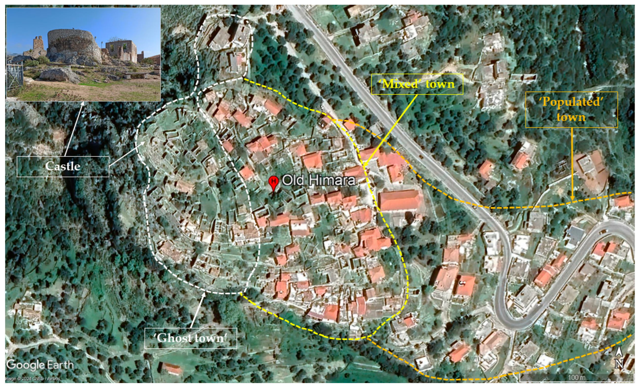
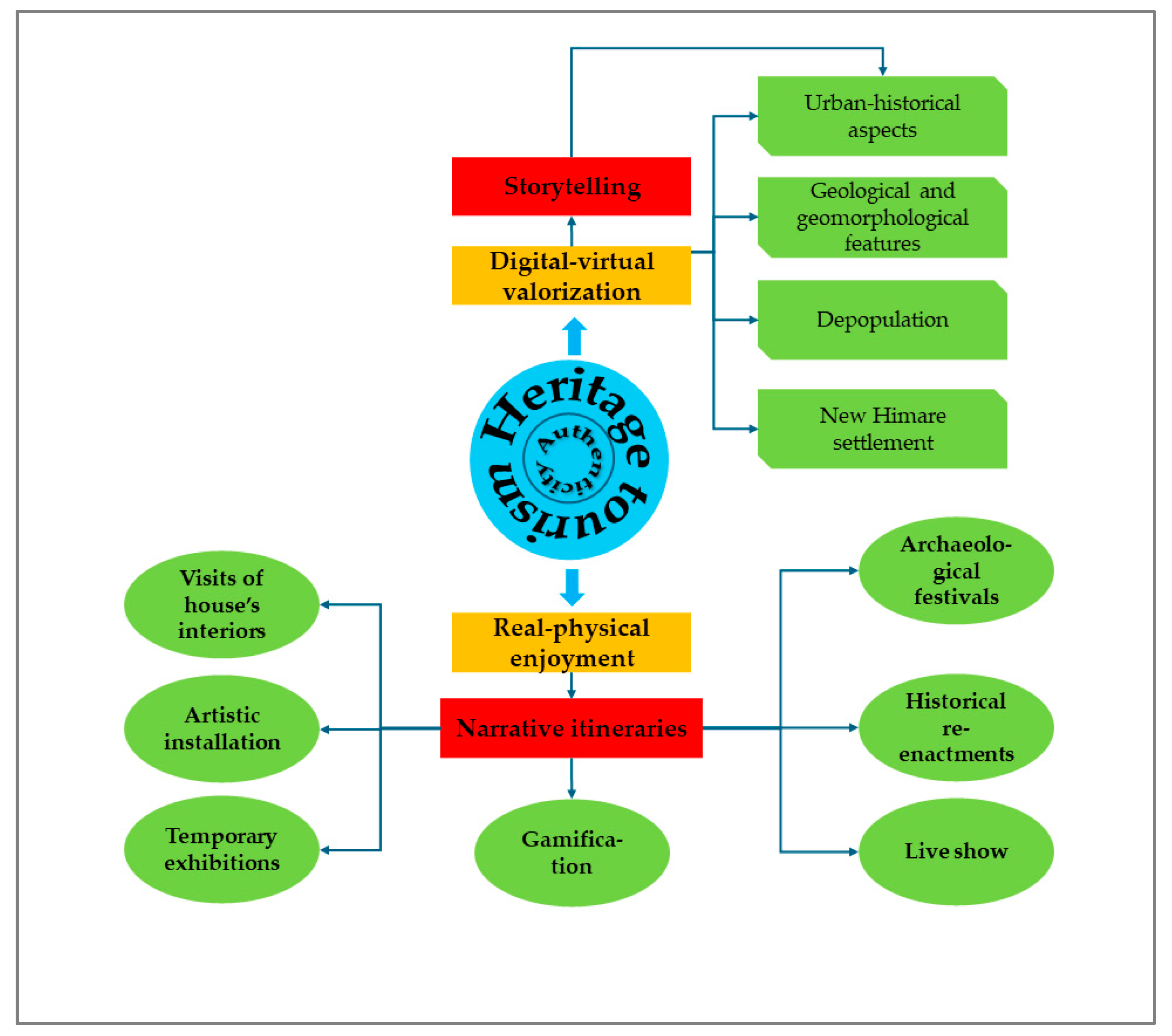
3.3. Old Himare: The Multiple and Competing Causes of Abandonment

3.3.1. Geographical and Historical Background

Old Himare (Lat. 40°7′3.02″ N, Long. 19°43′57.65″ E) lies in the southwest of Albania, on the coast of the Ionian Sea. The area where the town was built is a hilly mountainous area characterised by reliefs with slopes that fall directly into the Ionian Sea. Himare, whose history dates back 2500 years [86], was built on the hill of Barbaka. The town’s history started with the castle’s construction, which is located on the hilltop (Figure 17).
Nowadays, Old Himare can be divided into three areas with different degrees of population (Figure 17). In the western portion, around the castle, there is the proper ‘ghost town’ made up of abandoned buildings in a state of ruin and depopulated. The adjacent portion develops in sectors with abandoned buildings in a state of ruin and in wide areas where the buildings are restored after being abandoned, with the urban regeneration of the old town (‘mixed’ town). Conversely, the eastern part represents the most recent expansion area of the town.
Based on historical data and interviews taken from the inhabitants of Old Himare, we will now discuss the history of the settlement and the main phases and conditions on which the Himare population abandoned their homes under the influence of many factors, such as political, economic, social, religious, cultural, as well as natural hazards.
Himare is one of the earliest towns in Albania. The toponym probably derives from ‘Chimera’ [86,87], a mythological monster (https://himara.gov.al/monumente/kalaja-e-himares/, accessed 20 March 2024), or from ‘Χείμαρρος’ (stream), linked to its position on the stream that descends from the Acrocheraune mountain ranges, or, as it is called today, ‘Lightning Mountains’. In the 2nd century BC, the Romans conquered the territory, and General Lucio Emilio Paolo destroyed several settlements. The site is mentioned in the 1st century BC by Strabo: ‘On the Acrocerauni mountains there is the castle of Himare and the source of the royal water’ (Strabo, VII, 7.5.). Emperor Justinian rebuilt Himare Castle, also mentioned by Pliny the Elder (https://himara.gov.al/monumente/kalaja-e-himares/, accessed 20 March 2024).
The town is known for its castle and numerous churches, as well as its houses built from limestone stones. Several authors [86,87,88] have reported that Himare was an important centre in the southwest of Albania on the coast of the Ionian Sea. So, at the beginning of the 6th century, it was part of the ecclesiastical province of Chimaere [86,88]. At the end of the Middle Ages, Himare was the episcopal centre of the region [88].
The life of this town in the entire history of its development has faced many challenges in terms of social, religious, economic, and political development. In addition, it is documented by the finding of many ruins and traces of churches that Himare was a larger urban centre than it is today [86,88]. Historically, there have been glorious periods in social and economic terms, but the town has also suffered from many wars against invaders, who have played a major role in the development of the settlement. Thus, it has been documented that a massive emigration of the local population took place from this urban area, but it was also populated by residents from the northern and eastern parts of Albania.
After Frashëri (2005) [89] and other authors [86,87,88], it was reported that the abandonment of the old town of Himare was related to the emigration of the population from its occupation by the Ottoman Empire in the XV and XVIII centuries; from the Italian fascist and Nazi German occupation in 1939–1944; and from political, social, and religious conditions.
In 1431, Himare was included by the Turkish Empire as the province of Sanjak of Albania. In 1492, after the Ottoman invasion, a large part of the Himariote population, which did not fall under Turkish domination, emigrated to Calabria and Sicily (Italy) and Greece [89,90,91,92]. This population movement has been one of the largest emigrations of the population of Himare in its entire history. In Sicily, the inhabitants of Himare were assigned land near the city of Palermo and thus created a new settlement, which was later given the name ‘Hora’ and ‘Arbëreshëve’, ‘City of the Albanians’, where the inhabitants still speak Arbereshtoday and profess the Orthodox faith. Starting from the 16th century, following numerous riots, Himare, like Mirdita, secured some privileges and a partial self-government, which allowed it to preserve both the Albanian religion and flag. However, the lack of roads and the mountainous location of the settlement caused significant jams in communication with the inner areas of the country (https://albanian.cri.cn/culture/more/3104/20210201/614821.html, accessed 20 March 2024). Furthermore, it is worth mentioning that a migration of a large part of the villages of the province of Himare, including the present-day Old Himare, took place in 1744, when a significant part of the population of this province settled in the village of Villa Badessa, the municipality of Rosciano (Pescara province, Abruzzo, Italy) (http://www.villabadessa.it/storia/, accessed 20 March 2024).
Based on interviews and historical data obtained from the inhabitants of this area, it was presumed that several families from Old Himare moved to lower coastal areas such as Himare Town and other residential centres in Albania and abroad after the earthquake of 1893 [93]. Therefore, it is very important to emphasise that, besides social and political factors, one of the reasons for population migration was the damage and destruction of residential buildings, as well as the panic caused by the occurrence of earthquakes in Old Himare.
In the 20th century, during the years 1939–1944, the fascist Italian and Nazi German invasion of 1939–1944 and the war for liberation against it significantly affected the movement of the population of the province and Old Himare in particular [94]. Thus, about 24.5% of the population in this province emigrated to the US and some Latin American countries [94]. Also, it should be mentioned that after 1990, major social–economic political changes took place in Albania. The change of the planned socialist system to a private market economy was accompanied by a massive clandestine emigration, where about 68% of the population left Himare and its villages, settling permanently with their families, mainly in Greece, Italy, and Germany [94].

3.3.2. Geological Setting

Geologically (Figure 18), the area is composed of the Lower Jurassic (J1), Middle Jurassic (J2), Upper Jurassic (J3), carbonate formations of the Lower Cretaceous (Cr1), siliceous formations of the Upper Jurassic–Lower Cretaceous (J3-Cr1), and Quaternary deposits [95,96], which are briefly described here.
Siliceous formations are interbedded with a thin layer of beige marly shale. They are found in the centre and northeast of the studied area. Carbonate formations dominate most of the studied area. They are composed of thin-bedded limestones and dolomitic limestones (Figure 18), which are mainly beige and less grey in colour, compact, dense, and with low porosity as well. They have micro-fissures that are randomly oriented and cemented with calcite. The Quaternary deposits are represented by diluvium soils that consist of mixtures of angular gravels, sands, and fines (silts and clays). The content of gravel varied from 32 to 46%, that of sands varied between 25 and 37%, and that of fine soils (silts and clays) ranged from 27 to 39%. The gravels and sands have a limestone composition. These deposits are situated on hill slopes with a thickness ranging from 1–2.5 m to 3–4 m. According to [95,96], several tectonic fractures were identified in the study area, which has influenced its morphology. Thus, the tectonic activity created a differentiated relief that is expressed by the formation of mountain ridges, steep slopes, and deep and narrow valleys (Figure 18).

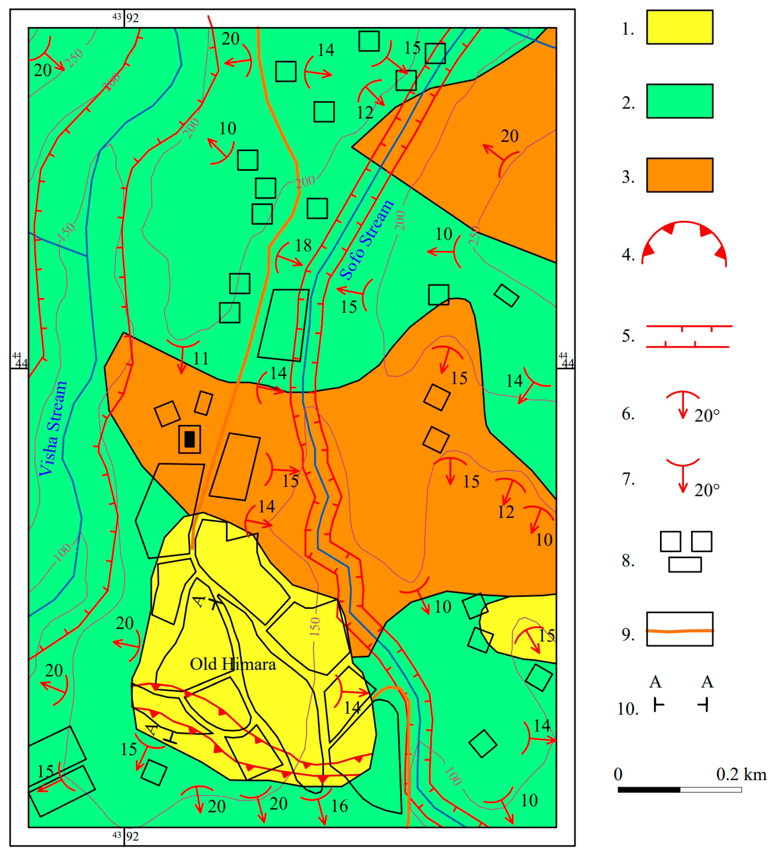
3.3.3. Geomorphological Setting

Geomorphologically, the studied area represents a hilly morphological unit, which is built by sedimentary formations, as are the limestone radiolarites, siliceous, and marly shale rocks. Along this zone are valleys, Visha and Sofo streams, and their torrents, which have narrow valleys with a ‘V’ shape (Figure 19). Morphologically, the hill on which Himare lies is characterised by various features such as escarpments, erosion channels, slopes with concave and convex shapes, as well as small flat surfaces in the form of terraces, which are mainly covered by vegetation (Figure 19). The altitude above sea level varies from about 50–150 m up to 180–200 m in the urban area. The hill’s slope angle ranges from 10 to 20° in the southern part and 20° up to 35 to 65° in the northern, western, and eastern parts of the hills. Generally, these formations on the surface are weathered and covered by soil deposits, which are 0.5–1.5 m up to 2.5–4 m thick.

3.3.4. Natural Hazards in Himare

The geotechnical and seismotectonic studies [93,96, 97, 98] were subjected to geodynamic phenomena such as earthquakes, mass movements, and erosion. The mass movements and erosion occurrences in this region are closely related to lithology characteristics and the geotechnical properties of rocks and soils, geomorphology, and rainfalls.

Mass Movements

A geotechnical mapping on a scale of 1:10,000 (Figure 20) was performed in the urban area of Old Himare, from which it was observed that the urban area in the southern part was affected partially by mass movement (Figure 20) such as creeping, which has a very slow movement rate of approximately 2–5 cm/year [82,99]. The slide’s body is composed of angular gravels and sands, as well as silts and clays. The slide plane is situated on the limestone rocks. The mass movement is mainly triggered by precipitation and a lack of engineering measures related to the drainage of surface water. We must emphasise that because of these massive movements, some old buildings, included in the list of cultural monuments in Albania, were damaged (cracks in the walls).

Earthquakes

Himare region extends to the Ionian Coast, which is one the most active seismic zones in Albania, characterised by earthquakes with maximum magnitude Mmax = 7.0 [100]. There have been many earthquakes that have occurred in the Himare area and the neighbouring region (Table 1), but we will deal with two of them since Himare and the villages around it were heavily affected by these events. So, on 14 June 1893, an earthquake with a magnitude M = 6.6 and hypocentral depth of 6.6 km occurred in the Himare area, causing severe consequences to the geo-environment and a loss of human life in many residential centres of the Himare region [93,96,97,98]. It is thought that many buildings of the old Himare were destroyed by this earthquake. Furthermore, Sulstarova & Koçiaj (1974) [97] and Aliaj et al. (2010) [98] reported another earthquake with magnitude M = 6.8 that occurred on Vlora’s Bay, 42 km north of Himare on 12 October 1851, causing damage to many houses and the death of many residents of the coastal area of the Ionian Sea, not only in Vlora but also in Himare to Saranda. This earthquake was one of the strongest that occurred in Albania, which was strongly felt in the southern part of Italy, Calabria, and Apulia regions, as far as Ioannina, Greece [98]. Based on historical data and interviews of the inhabitants of the area, we learned that several families from Old Himare moved to other sites after the earthquake of 1893, with special regard to the lower coastal areas (the new Himare Town, about 2 km south-east of the old town) and other residential centres both in Albania and abroad.
Therefore, it is very important to emphasise that in addition to the aforementioned factors, another reason for the emigration of the population and the abandonment of Old Himare was the damage and destruction of residential buildings caused by earthquakes, as well as the panic caused by the occurrence of such natural hazards.

3.3.5. Current Valorisation and Enjoyment

Currently, there are no real actions for the valorisation and enjoyment of the ‘ghost town’. Tourism is mainly linked to the castle, which was visited by an average of 2800 tourists per year in 2022 and 2023 [102].

4. Discussion

Here, we examine some of the tourism strategies to be considered by stakeholders and policymakers for Vilarinho da Furna, Campomaggiore vecchio, and Old Himare. Obviously, the decision on which solution to adopt depends on many factors, including technical and economic ones, which are only partially addressed here, going beyond the scope of the article.
Firstly, we emphasise the circumstance that the three ‘ghost towns’ investigated show different characteristics due to the distinct abandonment causes and the dissimilar degree of physical accessibility. These aspects influence the potential tourist schemes.
The valorisation and enjoyment of submerged settlements such as Vilarinho da Furna could be pursued through underwater tourism and the building of an underwater museum in the wake of the initiative scheduled for the Parque Natural de Vilarinho da Furna (Section 3.1.4). Public access to underwater heritage sites has been shown to have a positive effect on the local economy, making underwater tourism an attractive sector for cultural and active tourism [22,103]. As far as the authors of this article are aware, the literature has not investigated the possibility of this type of tourist exploitation for ‘ghost towns’.
An underwater museum (UM) can be used in three main ways: physical access, digital–virtual, and mixed (Figure 21). In turn, the real–physical fruition fulfilment of UM can be in ‘wet’ or ‘dry’ environments. Regarding the ‘wet’ environment, the UM can be accessible to scuba divers or snorkelers, like the MUSA (Underwater Museum of Art) in Cancún (Mexico; https://musamexico.org/, accessed 7 March 2024). Relative to the forms of public access, underwater museums can be divided into three main types: no direct access, controlled access/monitored diving, and unrestricted access [104]. The adopted type of access will depend on management policies or the limitations imposed by National/International laws and can be linked to the integrity and conservation requirements of submerged sites. Therefore, the definition of the strategy to be adopted requires specific legislative insights. Furthermore, direct tourist use should be balanced with the need to guarantee both the protection of the submerged heritage and the operativeness of the artificial reservoir. There are no specific studies on the matter, but we can deduce possible recommendations by analysing the literature regarding both the protection of submerged cultural heritage and the consequences of diving in artificial reservoirs [105,106,107,108]. In particular, it will be necessary to undertake targeted actions, such as (1) evaluating the impact that underwater activities could have on the functioning of the dam and safety of the artificial basin; (2) installing physical barriers around the submerged remains to protect them from accidental damage caused by divers; (3) providing guidelines to divers on how to behave while diving to avoid damage to the heritage; (4) establishing pre-defined underwater routes on the basis of an accurate survey of the bathymetry; and (5) offering educational programs and guided tours to increase divers’ awareness about the importance of the submerged site and the need for its conservation. Furthermore, educational programs will also contribute to enhancing diver experience and satisfaction.
However, the direct fruition of an underwater site cannot be achieved by everyone as it requires the specific skills of a diver with a breathing apparatus. Therefore, the tourist visit to a ‘dry’ environment could be the second option to fit the requirement of cultural democracy (Figure 21). In this wake, there are two solutions that could be adopted. The first is related to the building of an underwater museum that can be physically reached from the shore through a fixed tunnel [109], just a few tens of metres long. The second solution is a glass-bottom boat, thus allowing tourists to remain in dry conditions. This option also fits the actions scheduled for the Parque Natural de Vilarinho da Furna.
In addition to the physical approach to the enjoyment of the UM, another possibility to valorise and enjoy the UM could be the use of digital technologies (Figure 21) through virtual and/or augmented reality, taking advantage of experiences in the archaeological or marine biology sector [21,110,111]. Virtual reality refers to the use of software to create an immersive artificial environment by placing the user within an experience, blocking all the signals of the real-world, allowing interaction with a simulated real situation, and learning information about objects or locations [21,112,113]. Therefore, virtual reality allows the simulation of an experience like that of real life, while augmented reality is an enhanced version of reality where the real environments, in which people live, are integrated with digital information, increasing the possible obtained information that a person can take from the environment [113]. Digital technologies can generate a 3D virtual environment to provide tourists with the sensation of being underwater among the ruins of the submerged ‘ghost town’. In this way, tourists would virtually visit the submerged town through the point of view of a scuba diver, selecting travel routes and obtaining more information about the environmental context (e.g., marine, biological, and geological) and the specific features of the underwater town (e.g., cultural heritage and structure of the settlement) by interacting with specific points of interest (POI). However, digital technologies can also be useful in promoting and enriching the experience of both non-diving and diving users (Figure 21). For the latter, augmented reality can also help to guide divers through the underwater heritage, providing them with information about the most relevant POI [21] and enriching the underwater involvement. These digital technologies could be used in complementarity with the Ethnographic Museum of Vilarinho da Furna (or, in general, with the traditional museums dedicated to the abandoned towns) and in integration with the dissemination and communication activities carried out by tourist-reception structures (e.g., company management of sites, tourist information points), thus also stimulating the development of industries operating in the cultural and creative sector. Furthermore, a further novel approach to the valorisation and fruition of the Vilarinho da Furna UM could be its inclusion within eco-touristic and geo-touristic routes, such as those of the geosites, and ecological heritage from the Peneda-Gerês National Park, where the submerged site is located. Part of the route can be connected to the pedestrian trial already built in the framework of the Parque Natural de Vilarinho da Furna.
The application of such valorisation and fruition strategies could also be widely considered in other countries where underwater heritage is very frequent, such as Spain. Indeed, it is estimated that about 500 towns are currently submerged in the 1200 water reservoirs scattered across Spain, and countless others are abandoned in their vicinities [114]. Most of these reservoirs were planned during the Second Spanish Republic (1931–1939), taking advantage of article No. 44 of the 1931 Spanish Constitution dealing with the expropriation of social utilities. However, they were built later, in the 1950s and 1960s, during Franco’s dictatorship (1939–1975), which made the displacement of population and compensation for land and property lost much harsher [115]. The massive number of dams, reservoirs, and hydroelectric power plants built during the dictatorship was a response to a severe nationwide electricity supply deficit and a series of drought years that led to a change in the way the hydrological resources of the country were perceived and managed. Having such a high number of towns in this situation gives way to a relatively new type of tourism called drought season tourism, attracting even foreign visitors from England, France, and Germany. This trend made itself known, especially during the severe 2017 and 2022 droughts. Using both real–physical and digital–virtual approaches to tourism (concentrated in the dry season), seasonality could be significantly reduced by distributing it throughout the year.
The valorisation and enjoyment (currently limited) of Campomaggiore vecchio, as well as other sites abandoned due to the consequences of disasters triggered by natural hazards, can be framed within the context of dark tourism (Figure 22). Visitors engage in dark tourism for educational purposes, remembrance, sightseeing, recreation, family bonding, curiosity, and to seek a deeper understanding of historical events [116,117]. Dark tourism is gaining attention globally, with the potential for significant development of territories that embrace it [118,119]. Dark tourism has been considered for the Varosha ‘ghost town’ [18].
From this perspective, the valorisation and fruition of Campomaggiore can be enhanced through a dual action (Figure 22): the production of digital storytelling and the establishment of a geological theme park. The video–digital narration of the site history, to be used for preparing the site visit, could be effective in taking advantage of and expanding the settlement history illustrated by both the comics and multimedia–scenographical museum (see Section 3.2.6). However, to make the narration more captivating, the digital storytelling should make use of 3D digital reconstructions to illustrate both the urban growth of Campomaggiore vecchio over the centuries/decades and the landslide movement with the consequent concurring damage effects on the buildings. The whole narration should take advantage of the historical, geological, and geomorphological investigations described above. From this perspective, some of the authors of this article (FTG, NM, and MB) developed a digital narration of the settlement history of Craco, a famous ‘ghost town’ in Basilicata (Southern Italy), within the BEGIN project. The digital storytelling was planned to correlate the growth of the settlement over centuries with the geological–geomorphological features of the area and the natural hazards historically active on the site, which led to its forced abandonment in the 1960s. Dark sites can also be used as an educational source [120]. They have also been proposed as tools to raise awareness of natural hazard risks in national educational projects [121]. Therefore, the establishment of a geological theme park in Campomaggiore vecchio would be useful to increase awareness of natural hazard risks among people. In fact, recent research highlights how countries where the natural hazard risk is low show an over-awareness, while countries at high risk (such as Italy) are under-aware of natural hazards [122]. Furthermore, considering that ‘disasters strike when they [people] have faded from memory’ (Terada Torahiko, 1878–1935), local memory emerges as a powerful reminder of what could happen without mitigating the risks [123]. Therefore, education for preventing disasters brought about by geohazards and natural hazards is one of the useful tools that can be used to reduce casualties and mitigate risks [124,125]. Furthermore, past disaster damage can positively influence the public’s disaster-preparedness behaviours, with risk perception playing a mediating role in this relationship [126,127]. From this perspective, education based on disaster experiences testified by the ruins and damage of past abandoned settlements, such as Campomaggiore vecchio, can play an important role in increasing or maintaining a high level of hazard awareness in people, thus stimulating risk-mitigation actions and resilience growth. Likewise, the geological theme park could also be a proper site for developing training for university students, practitioners, and public administrators in charge of mitigating natural hazard risks. The mentioned digital storytelling makes evident the relationship between urban growth and natural processes, which would help develop education and training paths.
Due to its complex history, Himare can be valorised and enjoined through heritage tourism. Heritage tourism significantly contributes to the global economy, providing employment and serving political purposes by stimulating national pride and promoting cultural understanding [25]. Heritage tourism is also considered in revitalising mining ‘ghost towns’ in the US, Australia, and New Zealand [19] through different approaches. These assume the need to preserve the historical authenticity of buildings; develop education programs, culture initiatives, and outdoor activities; and engage the community. Overall, reviving ‘ghost towns’ can bring benefits by embracing economic, social, and cultural aspects [19].
The authenticity should be a crucial point to be considered by stakeholders and policymakers from the perspective of the touristic fruition of Himare. But what do we mean by it? Although some attempts have been made to classify the different types of authenticity of a historical place [128,129], authenticity should not be considered within rigid grouping schemes, but it should be seen as a process and concept socially constructed. Authenticity does not simply refer to a condition inherent to an object but is a term that can take on different and changing meanings in different contexts, in different places, for different people, but also for the same person at different times [130]. According to DeLyser (1999) [130], who analysed the mining ghost town of Bodie (California, US), visitors perceive a ghost town as authentic when it reveals its fragility when the buildings are not rebuilt or restored with invasive interventions, but when they are kept in a condition of ‘arrested decay’. This occurs when the artefacts and interiors of abandoned houses show signs of time and wear when the old settlement is not distorted, transforming it into a centre for tourist–commercial activities taken out of context (Figure 23). Only through the perceived ‘genuineness’ will the visitors be able to connect themselves with the past that the deserted town evokes: through the ruins, tourists will be able to feel and experience the past daily life of that place once inhabited, making a completely subjective and unique experience according to their own construction of authenticity. Altering the authenticity of the old town compromises its tourist potential for visitors who wish to experience the abandoned site as a time machine to turn the clock back to visit another time, another place, outside of the overwhelming modernity. Authenticity should be taken as a reference point for further fruition strategies.
To valorise the site and prepare visitors for the onsite tour in Himare, the use of storytelling techniques could be of particular interest, as the ‘ghost town’ is characterised by a complex abandonment history deriving from the interpenetration of different causes, such as political, social, and economic ones, as well as those linked to natural hazards (Figure 24).
According to Serrat (2017) [131], ‘storytelling is the vivid description of ideas, beliefs, personal experiences, and life lessons through stories or narratives that evoke powerful emotions and insights’. By captivating interpretations of the cultural contexts, digital storytelling can be an effective approach to promote both the involvement of visitors in sites of cultural interest and examine the matter more thoroughly [132,133,134]. Nowadays, the narrative approach could also benefit from cutting-edge technologies to support meaningful scriptwriters in developing automated storytelling that easily supports the creation of narrations [135], which helps to disclose the complex interconnection between the causes of town depopulation. The location for enjoying the storytelling could be positioned in the castle, from which the visit to the ‘ghost town’ should start.
The in situ, real–physical visit should be organised through ‘narrative itineraries’ that integrate not only the castle but also the churches and historical palaces of the ‘ghost town’ to promote a synoptic knowledge of the entire town (Figure 24). The route should include an exploration of the interiors of houses, thus allowing tourists to identify themselves in the daily life of the past through objects and furnishings. In this wake, along with the guided itinerary, permanent artistic installations or temporary art exhibitions connected to the phenomenon of abandonment should be included. Furthermore, the use of video performances with reconstructions, modelling, and animations could guide the tourist according to different levels of narration.
The complex history of the settlement should be passed on starting from the origins of the site (e.g., using myths, such as the Chimera, which gives life to the toponym, and literary sources, such as Strabo and Pliny the Elder) up to the Turkish occupation and the gradual abandonment due to emigration, the earthquakes of 1893 and 1966, and soil instability. To ensure an emotional and experiential experience and strengthen the value of the visit, additional strategies should be used. From this perspective, cultural events can play a significant role in the conservation of heritage, meeting consumers’ demands for innovative heritage consumption and creating long-lasting memories [136]. Therefore, historical re-enactments with ancient crafts, cultural events such as archaeological festivals, and theatrical and musical performances connected to the Arbëreshe traditions and the cultural mix between the Greek and Orthodox worlds would be suitable. In this phase, the involvement of the local community would be crucial to increase the connection between residents and sustainable heritage tourism [137], as made for the mining town of Bisbee, AZ, USA, where the strategy proved successful [19]. Furthermore, in order to boost the visitor experience, this should be combined with promoting outdoor activities and nature trails connected to the Spile Cave and the Pigeon Beach Cave (Ilias, 12.4 km away from the site) and supported by cognitive tools (topographic maps) and laboratory activities, including specific tours on the geological and geomorphological features of Himare, which can help to promote geoconservation and geo-education strategies [138,139]. At the end of the touristic course, a station with games and quizzes to check the level of knowledge learned will be useful to stimulate the visitors’ attention. Ultimately, the proposed strategy aims to develop an educational and cognitive approach, but above all, a complete, participatory, sensorial, and tailored tourist experience.

5. Conclusions

This research concerns the valorisation and enjoyment of ‘ghost towns’, with three case studies in mind: Vilarinho da Furna (Portugal), Campomaggiore vecchio (Italy), and Old Himare (Albania). Starting from an in-depth analysis of both site history and geological setting, as well as geomorphological features, we argued for the potential valorisation and enjoyment strategies to be applied by local/regional entities considering three different approaches: underwater tourism, dark tourism, and heritage tourism.
This is the first attempt at an international scale dealing with a wide approach to the tourism exploitation of ‘ghost towns’. Indeed, the analysis of three abandoned towns supported the discussion on the valorisation and enjoyment of such sites, a topic almost neglected in international literature. From this perspective, this article emphasises the role of digital technologies in the direct or indirect enjoyment of abandoned towns, the last one regarding sites that do not easily allow in-person experiences. Furthermore, through the case studies, we stress the circumstance that choices regarding valorisation and enjoyment should be made based on comprehensive knowledge of the characteristics of the site and the history of the abandoned settlements, correlating them to the causes that led the population to leave out the inhabited place.
This article also underlines that for the purposes of tourist use, the ‘authenticity’ of ghost towns should be guaranteed to allow visitors to live the old settlement as a time machine, projecting them outside of modernity. In this regard, this work also focused on the complex concept of authenticity of a historic site as a socially constructed value. Regarding this point, future research should investigate this meaning more thoroughly from the visitors’ point of view through questionnaires administered to tourists. This would allow for improved management strategies according to visitors’ expectations.
Finally, on the one hand, this article deals with three specific cases; on the other hand, it considers a methodological approach to the topic useful for setting out actions to valorise and enjoy worldwide ‘ghost towns’. However, further research on other case studies is desirable to identify additional strategies to be put in place for the touristic exploitation of abandoned villages. These studies will be carried out following the census, with an innovative methodology, of the Italian ‘ghost towns’ and the most important ‘ghost towns’ in the Mediterranean area. This census is being developed within the BEGIN project.

Author Contributions

Conceptualisation, F.T.G.; methodology, F.T.G., I.M.H.R.A., A.P.M.R., S.I.G., Y.M., E.P. and M.B.; validation, F.T.G.; resources, F.T.G., I.M.H.R.A., A.P.M.R., S.I.G., Y.M., E.P., M.R.P., A.S. and M.B.; data curation, F.T.G., I.M.H.R.A., A.P.M.R., S.I.G., Y.M., E.P. and M.B.; writing—original draft preparation, F.T.G., I.M.H.R.A., A.P.M.R., S.I.G., C.C.A., M.R.P., A.S., G.P., Y.M. and M.B.; writing—review and editing F.T.G., I.M.H.R.A., A.P.M.R., S.I.G., N.M., Y.M. and M.B., supervision, F.T.G.; project administration, F.T.G. and M.B.; funding acquisition, F.T.G. and M.B. All authors have read and agreed to the published version of the manuscript.

Funding

The research activity was sustained by the BEGIN project (DUS.AD017.190, CUP C39J20001760002), financed by Basilicata ERDF-ROP 2014–2020. Funding was granted to the Institute of Heritage Science, National Research Council (ISPC-CNR) and University of Basilicata and Under the projects UIDB/04683/2020 and UIDP/04683/2020 from FCT—Fundação para a Ciência e a Tecnologia, I.P. (Portugal).

Data Availability Statement

The original contributions presented in the study are included in the article, further inquiries can be directed to the corresponding author.

Acknowledgments

We would like to thank the editor and three anonymous reviewers whose very careful reports allowed us to improve the original version of the manuscript. We would also like to thank the reviewers for their positive comments and congratulations on the research work.

Conflicts of Interest

The authors declare no conflicts of interest.

Notes

1 
ASDPC (Archivio storico del Dipartimento della Protezione Civile). Foto area di Campomaggiore vecchio (1966)
2 
ASPZ (Archivio di Stato di Potenza). Intendenza di Basilicata (1806–1860), Costruzione della Chiesa. B. 940, Fasc. 87
3 
ASPZ (Archivio di Stato di Potenza). Fondo Intendenza di Basilicata (1806–1860). Terremoto del 1857. Danni a Campomaggiore. Busta 1371
4 
ASPZ (Archivio di Stato di Potenza). Fondo Prefettura. Atti amministrativi (1878–1882), Lettera del Prefetto di Potenza al Sindaco di Campomaggiore, Potenza 11 luglio 1878. Busta 371, Fasc. 6

References and Notes

  1. WPH. World Population Highlights 2007: Urbanization. 2007. Available online: https://www.prb.org/resources/%20world-population-highlights-2007-urbanization/ (accessed on 4 April 2024).
  2. EC. Urbanisation Worldwide. Competence Centre on Foresight of the European Commission. 2020. Available online: https://knowledge4policy.ec.europa.eu/foresight/topic/continuing-urbanisation/urbanisation-worldwide_en (accessed on 4 April 2024).
  3. East, M. Integrated approaches and interventions for the regeneration of abandoned towns in southern Italy. In From Conflict to Inclusion in Housing: Interaction of Communities, Residents and Activists; Cairns, G., Artopoulos, G., Day, K., Eds.; UCL Press: London, UK, 2017; pp. 87–102. Available online: https://www.jstor.org/stable/j.ctt1xhr55k.12 (accessed on 20 December 2023).
  4. Beresford, M.W.; Hurst, J.G. Deserted Medieval Villages; Lutterworth: Guildford, UK, 1971. [Google Scholar]
  5. Demians D’archimbaud, G. Archéologie du village désertè. Ann. Èconomies Sociétès Civilis. 1974, 29, 834–837. [Google Scholar]
  6. Cameron, C.M.; Tomka, S.A. Abandonment of Settlements and Regions: Ethnoarchaeological and Archaeological Approaches; Cambridge University Press: New York, NY, USA, 1993. [Google Scholar]
  7. Diamond, J. Collapse: How Societies Choose to Fail or Succeed; Penguin Books: London, UK, 2005. [Google Scholar]
  8. Beard, M. The Fires of Vesuvius: Pompeii Lost and Found; Harvard University Press: Cambridge, MA, USA, 2010. [Google Scholar]
  9. Lasaponara, R.; Masini, N. Full-waveform airborne laser scanning for the detection of medieval archaeological microtopographic relief. J. Cult. Herit. 2009, 10, e78–e82. [Google Scholar] [CrossRef]
  10. Gizzi, F.T.; Bentivenga, M.; Lasaponara, R.; Danese, M.; Potenza, M.R.; Sileo, M.; Masini, N. Natural Hazards, Human Factors, and “Ghost Towns”: A Multi-Level Approach. Geoheritage 2019, 11, 1533–1565. [Google Scholar] [CrossRef]
  11. Galadini, F. Ruins and Remains as a Background: Natural Catastrophes, Abandonment of Medieval Villages, and the Perspective of Civilization during the 20th Century in the Central Apennines (Abruzzi Region, Central Italy). Sustainability 2022, 14, 9517. [Google Scholar] [CrossRef]
  12. Bentivenga, M.; Pescatore, E.; Piccarreta, M.; Gizzi, F.T.; Masini, N.; Giano, S.I. Geoheritage and Geoconservation, from Theory to Practice: The Ghost Town of Craco (Matera District, Basilicata Region, Southern Italy). Sustainability 2024, 16, 2761. [Google Scholar] [CrossRef]
  13. Masini, N.; Abate, N.; Gizzi, F.T.; Vitale, V.; Minervino Amodio, A.; Sileo, M.; Biscione, M.; Lasaponara, R.; Bentivenga, M.; Cavalcante, F. UAV LiDAR Based Approach for the Detection and Interpretation of Archaeological Micro Topography under Canopy—The Rediscovery of Perticara (Basilicata, Italy). Remote Sens. 2022, 14, 6074. [Google Scholar] [CrossRef]
  14. Duda, A. Tourist photography and heritage. The case of the abandoned city of Pripyat. J. Herit. Tour. 2023, 18, 384–400. [Google Scholar] [CrossRef]
  15. Pirlone, F. I Borghi Antichi Abbandonati. Patrimonio da Riscoprire e Mettere in Sicurezza; Franco Angeli Editore: Milano, Italy, 2016; ISBN 9788891740588. (In Italian) [Google Scholar]
  16. Peyton, P.M. The Archaeology of Abandonment Ghost Towns of the American West. Ph.D. Thesis, School of Archaeology and Ancient History, University of Leicester, Leicester, UK, 2012. [Google Scholar]
  17. Larrain, B.F.; Sachs, J.D.; Warner, A. A Structural Analysis of Chile’s Long-Term Growth: History, Prospects and Policy Implications; Paper prepared for the Government of Chile; Columbia University: New York, NY, USA, 2000. [Google Scholar] [CrossRef]
  18. Sterling, C. Spectral Anatomies: Heritage, Hauntology and the ‘Ghosts’ of Varosha. Present Pasts 2014, 6, 1–15. [Google Scholar] [CrossRef]
  19. Nag, A.; Mishra, S. Mining Ghost Town Revitalization through Heritage Tourism Initiatives. J. Min. Environ. 2024, 15, 439–461. [Google Scholar] [CrossRef]
  20. Nunes, C.H.; Roeder, F. Tourism and algarve’s underwater heritage valorisation. A case study. J. Mar. Res. 2014, 11, 35–44. [Google Scholar]
  21. Bruno, F.; Ricca, M.; Lagudi, A.; Kalamara, P.; Manglis, A.; Fourkiotou, A.; Papadopoulou, D.; Veneti, A. Digital Technologies for the Sustainable Development of the Accessible Underwater Cultural Heritage Sites. J. Mar. Sci. Eng. 2020, 8, 955. [Google Scholar] [CrossRef]
  22. Pérez-Reverte Mañas, C.; Cerezo Andreo, F.; López Osorio, P.; González Gallero, R.; Mariscal Rico, L.; Arévalo González, A. Underwater Cultural Heritage as an Engine for Social, Economic and Cultural Development. State of Research at the University of Cadiz (Andalusia, Spain). Heritage 2021, 4, 2676–2690. [Google Scholar] [CrossRef]
  23. Lennon, J.J.; Foley, M. Dark Tourism: The Attraction of Death and Disaster; Continuum: London, UK, 2000; p. 184. [Google Scholar]
  24. Binik, O. The dark tourism phenomenon in contemporary society: A critical review of literature. Rass. Ital. Di Sociol. 2016, 57, 551–574. [Google Scholar]
  25. Salazar, N.B. The local-to-global dynamics of world heritage interpretation. In World Heritage, Tourism and Identity: Inscription and Co-Production, 1st ed.; Bourdeau, L., Gravari-Barbas, M., Robinson, M., Eds.; Routledge: London, UK, 2015; p. 10. [Google Scholar] [CrossRef]
  26. Chen, J.S. Travel Motivation of Heritage Tourists. The Heritage Tourist Experience: Critical Essays, 1st ed.; Routledge: London, UK, 2017; Volume 2, p. 548. [Google Scholar] [CrossRef]
  27. Timothy, D.J. Cultural Heritage and Tourism: An Introduction, 2nd ed.; Channel View Publications: Bristol, UK, 2020; p. 549. [Google Scholar]
  28. Decree Law 1971. Decreto n.º 187/71, de 8 de Maio—Cria o Parque Nacional da Peneda-Gerês. Diário do Governo n.º 108/1971, Série I de 1971-05-08; pp. 657–661.
  29. Djajkovski, P. Underwater Ghost Village in Portugal, Vilarinho da Furna. 2017. Available online: https://www.abandonedspaces.com/towns/underwater-ghost-village-in-portugal-vilarinho-da-furna.html (accessed on 7 November 2023).
  30. Decree Law 1944. Lei 2002—Outorga a Eletricidade de Portugal à Empresa Pública (EDP). 20 de dezembro de 1944.
  31. Antunes, M.A. Memórias de Vilarinho da Furna—Uma Aldeia Afundada; Grupo Folclórico Verde Minho: Loures, Portugal, 2018; p. 21. [Google Scholar]
  32. Trigo, R.; DaCâmara, C. Circulation weather types and their influence in the precipitation regime in Portugal. Int. J. Climatol. 2000, 20, 1559–1581. [Google Scholar] [CrossRef]
  33. Daveau, S.; Coelho, C.; Costa, V.G.; Carvalho, L. Répartition et Rhytme des Precipitations au Portugal. Memórias do Centro de Estudos Geográficos 3; Centro de Estudos Geográficos: Lisboa, Portugal, 1977; p. 192. [Google Scholar]
  34. Pereira, P.; Pereira, D.I. The Granite and Glacial Landscapes of the Peneda-Gerês National Park. In Landscapes and Landforms of Portugal. World Geomorphological Landscapes; Vieira, G., Zêzere, J., Mora, C., Eds.; Springer: Berlin/Heidelberg, Germany, 2020. [Google Scholar] [CrossRef]
  35. Dias, G.; Leterrier, J.; Mendes, A.; Simões, P.; Bertrand, J. U-Pb zircon and monazite geochronology of post-collisional Hercynian granitoids from the Central Iberian Zone (Northern Portugal). Lithos 1988, 45, 349–369. [Google Scholar] [CrossRef]
  36. Mendes, A.; Dias, G. Mantle like Sr-Nd isotope composition of Fe-K subalkaline granites: The Peneda-Gêres Variscan massif (NW Iberian Peninsula). Terra Nova 2004, 16, 109–115. [Google Scholar] [CrossRef]
  37. Lima, A.S. Modelo Conceptual da Ocorrência Hidromineral do Gerês: Fundamentos Sobre a Delimitação da Área de Recarga do Sistema Hidrotermal; Artigo em Ata de Conferência; 2011; pp. 169–182. ISBN 978-989-97402-0-4. Available online: https://www.rcaap.pt/detail.jsp?id=oai:repositorium.sdum.uminho.pt:1822/15148 (accessed on 18 July 2024).
  38. Cloetingh, S.; Burov, E.; Beekman, F.; Andeweg, B.; Andriessen, P.A.M.; García-Castellanos, D.; De Vicente, G.; Vegas, R. Lithospheric folding in Iberia. Tectonics 2002, 21, 1041–1067. [Google Scholar] [CrossRef]
  39. Cunha, P.P.; Pimentel, N.L.; Pereira, D.I. Assinatura tectono-sedimentar do auge da compressão bética em Portugal. A descontinuidade Valesiano terminal-Turoliano. Ciências Da Terra 2000, 14, 61–72. [Google Scholar]
  40. Cabral, J. Neotectonics of mainland Portugal: State of the art and future perspectives. J. Iber. Geol. 2012, 38, 71–84. [Google Scholar] [CrossRef]
  41. Pereira, D.I.; Pereira, P.; Santos, L.; Silva, J. Unidades Geomorfológicas de Portugal Continental. Rev. Bras. Geomorfol. 2014, 15, 567–583. [Google Scholar] [CrossRef]
  42. Coudé-Gaussen, G. Coudé-Gaussen, Geneviève. Les Serras da Peneda et do Gerês (Minho, Portugal): étude Géomorphologique; Centro de Estudos Geográficos: Lisboa, Portugal, 1981; 275p. [Google Scholar]
  43. Ferreira, A.B.; Vidal Romani, J.R.; Zêzere, J.L.; Rodrigues, M.L. A Glaciação Plistocénica da Serra do Gerês. Vestígios Geomorfológicos e Sedimentológicos. Relatório 37; Centro de Estudos Geográficos: Lisboa, Portugal, 1999; p. 150. [Google Scholar]
  44. Vidal Romani, J.R.; Vaqueiro, M.; Sanjurjo, J. Granite Landforms in Galicia. In Landscapes and Landforms of Spain. World Geomorphological Landscapes Series; Gutiérrez, F., Gutiérrez, M., Eds.; Springer: Berlin/Heidelberg, Germany, 2014; pp. 63–69. [Google Scholar]
  45. Girão, A.A. Glaciação Quaternária na Serra do Jures. Bol. Cent. Estud. Geográficos 1958, 11, 13–22. [Google Scholar]
  46. Hughes, P.; Woodward, J.; Gibbard, P. Quaternary glacial history of the Mediterranean Mountains. Prog. Phys. Geogr. 2006, 30, 334–364. [Google Scholar] [CrossRef]
  47. Pereira, P.; Pereira, D.I. Geomorfologia glaciária e peri-glaciária em Portugal. Contributo para a inventariação do património geológico português. Publicações Assoc. Port. Geomorfólogos 2009, 6, 279–284. [Google Scholar]
  48. Pereira, D.I.; Pereira, P.; Brilha, J.; Cunha, P.P. The Iberian Massif landscape and fluvial network in Portugal: A geoheritage inventory based on scientific value. Proced. Geol. Assoc. 2015, 126, 252–265. [Google Scholar] [CrossRef]
  49. Brilha, J.B.; Pereira, P. Geoconservation in Portugal with emphasis on the geomorphological heritage. In Landforms and Landscapes of Portugal; Vieira, G., Zêzere, J.L., Mora, C., Eds.; World geomorphological Landscape Series; Springer: Berlin/Heidelberg, Germany, 2020. [Google Scholar]
  50. Antunes, M.A. Vilarinho da Furna—Uma Aldeia Afundada; A Regra do Jogo Edições: Lisboa, Portugal, 1985. [Google Scholar]
  51. EMVF (Terras de Bouro, Portugal). Ethnographic Museum of Vilarinho da Furna. Number of tourists for the year 2022 and 2023. Personal communication to I.M.H.R.A., 14 June 2024.
  52. EMVF (Terras de Bouro, Portugal). Ethnographic Museum of Vilarinho da Furna. Number of tourists for the year 2022 and 2023. Personal communication to A.S., 16 May 2024.
  53. Antunes, M.A. Requiem por Vilarinho da Furna—Uma Aldeia afundada. Coleção Meia Hora de Leitura; Biblioteca da Universidade Lusófona: Lisboa, Portugal, 1994. [Google Scholar]
  54. AFURNA; ICNB; EDP; CCDRN; INAG; FEUP. Natur parque de Vilarinho da Furna. Brochure. Undated, without publisher, without date.
  55. Municipality of Terras de Bouro. Personal communication to F.T.G., 28 June 2024.
  56. Gizzi, F.T.; Sileo, M.; Biscione, M.; Danese, M.; de Buergo, M.A. The conservation state of the Sassi of Matera site (Southern Italy) and its correlation with the environmental conditions analysed through spatial analysis techniques. J. Cult. Herit. 2016, 17, 61–74. [Google Scholar] [CrossRef]
  57. Gizzi, F.T.; Proto, M.; Potenza, M.R. The Basilicata region (Southern Italy): A natural and ‘human-built’ open-air laboratory for manifold studies. Research trends over the last 24 years (1994–2017). Geomat. Nat. Hazards Risk 2019, 10, 433–464. [Google Scholar] [CrossRef]
  58. Pescatore, E.; Bentivenga, M.; Giano, S.I. Geoheritage Management in Areas with Multicultural Interest Contexts. Sustainability 2022, 14, 15911. [Google Scholar] [CrossRef]
  59. Cutinelli, G. (a) Lucania Letteraria, n. 7, Potenza, domenica 29 Marzo 1885.
  60. Filardi, G. Campomaggiore. Storia di un Paese Lucano; Litostampa Ottaviano: Rionero in Vulture, Italy, 1985. (In Italian) [Google Scholar]
  61. Rescio, P. Campomaggiore: Archeologia dell’Edilizia Storica; Centro Studi per la Storia della Cultura Materiale nel Mezzogiorno, Tipo-Litografia Cautillo: Vallesaccarda, Italy, 1997. (In Italian) [Google Scholar]
  62. Damone, G. Lettura Storico Critica di una Ghost Town: Il Progetto Utopico di Campomaggiore; CUES: Fisciano, Italy, 2013; p. 304. (In Italian) [Google Scholar]
  63. Rescio, P. Un piano per la valorizzazione di Campomaggiore. Basilicata Reg. Not. Agenzia Settim. Di Inf. 2000, 24, 63–66. (In Italian) [Google Scholar]
  64. Trigila, A.; Iadanza, C.; Bussettini, M.; Lastoria, B. Dissesto Idrogeologico in Italia: Pericolosità e Indicatori di Rischio; ISPRA: Rome, Italy, 2018. (In Italian)
  65. Gizzi, F.T.; Potenza, M.R. The Scientific Landscape of November 23rd, 1980 Irpinia-Basilicata Earthquake: Taking Stock of (Almost) 40 Years of Studies. Geosciences 2020, 10, 482. [Google Scholar] [CrossRef]
  66. Locati, M.; Camassi, R.; Rovida, A.; Ercolani, E.; Bernardini, F.; Castelli, V.; Caracciolo, C.H.; Tertulliani, A.; Rossi, A.; Azzaro, R.; et al. Database Macrosismico Italiano (DBMI15), Versione 4.0 [Data Set]; Istituto Nazionale di Geofisica e Vulcanologia (INGV): Rome, Italy, 2022. [CrossRef]
  67. Ducci, A. Osservazioni geologiche sul territorio di Campomaggiore Nuovo (Potenza) e sulla frana che minaccia l’abitato. Boll. Serv. Geol. D’italia 1950, LXX, 199–223. (In Italian) [Google Scholar]
  68. Fittipaldi, E. Relazione su disastro di Campomaggiore. Bull. Vulcan. Ital. Period. Dell’osservatorio Ed Arch. Cent. Geodin. 1885, XII, 57–58. (In Italian) [Google Scholar]
  69. Cutinelli, G. (b) Lucania Letteraria, n. 8, Potenza, domenica 5 aprile 1885. (In Italian).
  70. De Rossi, M.S. Intorno ad alcuni risultati degli odierni studi sismologici posti in relazione coll’edilizia. Bull. Vulcan. Ital. Period. Dell’osservatorio Ed Arch. Cent. Geodin. 1885, XII, 55–56. (In Italian) [Google Scholar]
  71. Patacca, E.; Scandone, P. Geology of the southern Apennines, In: Mazzotti A., Patacca E & Scandone P. Eds., The CROP 04 transect. Southern Apennine. Boll. Soc. Geol. Ital. 2007, 7, 75–119. [Google Scholar]
  72. Mostardini, F.; Merlini, S. Appennino Centro Meridionale. Sezioni geologiche e proposta di modello strutturale. Mem. Soc. Geol. Ital. 1986, 35, 177–202. (In Italian) [Google Scholar]
  73. Pescatore, T.; Renda, P.; Schiattarella, M.; Tramutoli, M. Stratigraphic and Structural relationships between Meso-Cenozoic Lagonegro basin and coeval carbonate platforms in southern Apennines, Italy. Tectonophysics 1999, 315, 269–286. [Google Scholar] [CrossRef]
  74. Scandone, P.; Bonardi, G. Synsedimentary tectonics controlling deposition of Mesozoic and Tertiary carbonatic sequences of areas surrounging Vallo di Diano (Southern Appennines). Mem. Soc. Geol. Ital. 1968, 7, 1–10. [Google Scholar]
  75. Lentini, F.; Carbone, S.; Di Stefano, A.; Guarnieri, P. Stratigraphical and structural constraints in the Lucanian Apennines (southern Italy): Tools for reconstructing the geological evolution. J. Geodyn. 2002, 34, 141–158. [Google Scholar] [CrossRef]
  76. Piedilato, S.; Prosser, G. Thrust sequences and evolution of the external sector of a fold and thrust belt: An example from the Southern Apennines (Italy). J. Geodyn. 2005, 39, 386–402. [Google Scholar] [CrossRef]
  77. Ciarapica, G.; Cirlli, S.; Panzanelli Fratoni, R.; Passeri, L.; Zaninetti, L. The Monte Facito Formation (Southern Apennines). Boll. Soc. Geol. Ital. 1990, 109, 135–142. [Google Scholar]
  78. Palladino, G.; Prosser, G.; Bentivenga, M.; Alsop, G.I. Mass transport deposits overprinted by contractional tectonics: A case study from the southern Apennines of Italy. Geol. Mag. 2019, 156, 849–873. [Google Scholar] [CrossRef]
  79. Carbone, S.; Catalano, S.; Lentini, F.; Monaco, C. Le unità stratigrafico-strutturali dell’alta val dAgri (Appennino lucano) nel quadro dell’evoluzione del sistema catena-avanfossa. Mem. Soc. Geol. Ital. 1988, 41, 331–341. (In Italian) [Google Scholar]
  80. Patacca, E.; Scandone, P.; Bellatalla, M.; Perilli, N.; Santini, U. The Numidian-sandevent in the southern Apennines. Mem. Sci. Geol. 1992, 43, 297–337. [Google Scholar]
  81. Varnes, D.J. Slope movement, types and processes. In Landslides, Analysis and Control; Schuster, R.L., Krizek, R.J., Eds.; National Academy of Sciences, Special Report 176; Transportation Research Board, Commission on Sociotechnical Systems, National Research Council: Washington, DC, USA, 1978; pp. 11–33. [Google Scholar]
  82. Cruden, D.M.; Varnes, D.J. Landslide types and processes. In Landslides: Investigations and Mitigation, Transportation Research Board; Turner, A.K., Schuster, R.L., Eds.; special report 247; National Academy of Sciences: Washington, DC, USA, 1996; pp. 36–71. [Google Scholar]
  83. Bruschella, G. Tomografie Geoelettriche per lo Studio Della Frana di Campomaggiore Vecchio. Bachelor’s Thesis, Università degli Studi della Basilicata, Basilicata, Italy, 2003. (In Italian). [Google Scholar]
  84. Sdao, F.; Simeone, V. Fasi di attivazione e maturità geomorfologica di due frane tipo colata nei pressi di Campomaggiore Vecchio (Basilicata). Geol. Appl. Ed Idrog. 1996, XXXI, 155–168. (In Italian) [Google Scholar]
  85. Municipality of Campomaggiore. Number of tourists in Campomaggiore vecchio for the years 2022. Personal communication to A.S., 20 April 2024.
  86. Sinani, S. Himara: Community identity and ethnotype. In Himara in the Centuries; Prifti, K., Nasi, L., Eds.; Academy of Sciences: Tirana, Albania, 2004; pp. 320–352. [Google Scholar]
  87. Valentini, G. Contributions to the Albanian Chronology; Rome, Italy, 1944; p. 404.
  88. Zamputi, I. Documents of the XVI–XII Centuries for the History of Albania; Academy of Sciences: Tirana, Albania, 1989; Volume I, pp. 353–355. [Google Scholar]
  89. Frashëri, K. Himara and the Ethnicity of the Himara People; “Toena” Publishing House: Tirana, Albania, 2005; p. 104. ISBN 99927-1-951-6. [Google Scholar]
  90. Sathas, C.N. Documents Relating to the History of Greece or the Middle Ages; Paris, France, 1886; Volume VI, p. 236.
  91. Zamputi, I. Documents of the XV Century on the History of Albania; Tirana, Albania, 1967; Volume IV (1479–1506), part I (1479–1499), pp. 100–101
  92. Thëngjilli, P. Aspects of the Himara people’s efforts for freedom (XVI–XVIII centuries). Science Academy. In Himara in the Centuries; Prifti, K., Nasi, L., Eds.; Academy of Sciences: Tirana, Albania, 2004; pp. 124–149. [Google Scholar]
  93. Muceku, Y.; Koçi, R.; Mustafaraj, E.; Korini, O.; Dushi, E.; Duni, L. Earthquake-triggered mass movements in Albania. Acta Geod. Geophys. 2021, 56, 439–470. [Google Scholar] [CrossRef]
  94. Bërxholi, A. Land administrative organization of the coast after 1913 until today. In Himara in the Centuries; Prifti, K., Nasi, L., Eds.; Academy of Sciences: Tirana, Albania, 2004; pp. 228–235. [Google Scholar]
  95. Prrenjasi, E.; Çuri, F.; Iliazi, F. Geological Map of the Himare Region, Scale: 12500; Albanian Geological Service: Tirana, Albania, 1980. [Google Scholar]
  96. Muceku, Y.; Lamaj, M.; Milushi, I.; Onuzi, K.; Avxhiu, A. Preliminary results of the Albanian geotechnical map at the scale 1:200000: A case study. Albanian J. Nat. Tech. Sci. 2019, 50, 7–25. [Google Scholar]
  97. Sulstarova, E.; Koçiaj, S. Earthquakes Catalog; Institute of Geosciences, Polytechnic University of Tirana: Tirana, Albania, 1974; pp. 113–115. [Google Scholar]
  98. Aliaj, S.; Kociu, S.; Muco, B.; Sulstarova, E. Seismicity, seismotectonics and seismic hazard assessmentin Albania. Academy of Sciences of Albania. Monography 2010, 13, 95–230. [Google Scholar]
  99. Muceku, Y.; Lamaj, M. The importance and needs of engineering geological mapping in the development and urban planning of Albania. Bull. Geol. Sci. 2009, 2, 99–118. [Google Scholar]
  100. Muço, B. Probabilistic seismic hazard assessment in Albania. Ital. J. Geosci. 2013, 132, 194–202. [Google Scholar] [CrossRef]
  101. Papazachos, B.C.; Savvaidis, A.S.; Papazachos, C.B.; Papaioannou, C.A.; Kiratzi, A.A.; Muço, B.; Kociuand, S.; Sulstarova, E. Atlas of Isoseismic Maps for Shallow Earthquakes in Albania and Surrounding Area (1851–1990); Publication No 10; University of Thessaloniki, Geophysical Laboratory: Thessaloniki, Greece, 2001; pp. 4–48. [Google Scholar]
  102. Albanian Cultural Institute (, Tirana, Albania, Country). Number of tourists in Old Himare for the years 2022 and 2023. Personal communication to A.S. 2023.
  103. Drouga, V.; Sarantakou, E. The Promotion of Underwater Cultural Heritage Sites in the Digital Era: The Case of Peristera Classical Shipwreck in Alonissos. In Recent Advancements in Tourism Business, Technology and Social Sciences; Katsoni, V., Cassar, G., Eds.; IACuDiT 2023; Springer Proceedings in Business and Economics; Springer: Cham, Switzerland, 2024; pp. 833–844. [Google Scholar] [CrossRef]
  104. Güzden, V. Assessing a Decade of Kas¸ Underwater Archaeopark. Int. J. Naut. Archaeol. 2020, 49, 74–86. [Google Scholar] [CrossRef]
  105. Cho, H. The challenges and needs of museums in safeguarding underwater cultural heritage. Mus. Manag. Curatorship 2014, 29, 429–444. [Google Scholar] [CrossRef]
  106. Jung, R.-T.; Isshiki, H. Application of tidal energy for purification in fresh water lake. Int. J. Nav. Archit. 2015, 7, 212–225. [Google Scholar] [CrossRef]
  107. Edney, J.; Dimmock, K.; Boyd, W.E. Understanding Diver Behavior on Underwater Cultural Heritage: Enriching the Observation Record Using Video Methods. Sustainability 2021, 13, 5601. [Google Scholar] [CrossRef]
  108. Set, K.; Mohd Salleh, N.H.; Mhd Rashid, M.; Nasir, A. An exploratory study on professional competencies of scuba dive guides in Malaysia. J. Sustain. Sci. Manag. 2023, 18, 137–158. [Google Scholar] [CrossRef]
  109. Poulos, S.E.; Panagopoulou, A.; Kotinas, C. An oceanographic insight in the submergence and resilence of the Pavlopetri archaeological site. Sci. Cult. 2022, 8, 161–173. [Google Scholar]
  110. Manju, T.; Francis, A.; Sankar, N.; Azzarudin, T.; Magesh, B. VR Based Underwater Museum of Andaman and Nicobar Islands. In Information and Communication Technology for Intelligent Systems. ICTIS 2020. Smart Innovation, Systems and Technologies; Senjyu, T., Mahalle, P.N., Perumal, T., Joshi, A., Eds.; Springer: Singapore, 2021; Volume 196, pp. 627–632. [Google Scholar] [CrossRef]
  111. Ricca, M.; Alexandrakis, G.; Bonazza, A.; Bruno, F.; Davidde Petriaggi, B.; Elkin, D.; Lagudi, A.; Nicolas, S.; Novák, M.; Papatheodorou, G.; et al. A Sustainable Approach for the Management and Valorization of Underwater Cultural Heritage: New Perspectives from the TECTONIC Project. Sustainability 2020, 12, 5000. [Google Scholar] [CrossRef]
  112. Anderson, E.F.; McLoughlin, L.; Liarokapis, F.; Peters, C.; Petridis, P.; de Freitas, S. Developing serious games for cultural heritage: A state-of-the-art review. Virtual Real 2010, 14, 255–275. [Google Scholar] [CrossRef]
  113. Fernandez, M. Augmented virtual reality: How to improve education systems. High. Learn. Res. Commun. 2017, 7, 1–15. Available online: https://biblioproxy.cnr.it:2481/10.18870/hlrc.v7i1.373 (accessed on 20 April 2024). [CrossRef]
  114. Bazán, R. Iberia emergida, ¿memoria sumergida? La Tadeo DeArte 2019, 5, 82–95. (In Portuguese) [Google Scholar] [CrossRef]
  115. Camprubí, L. (2019). Ante la Pertinaz Sequía: ¿qué hacemos con Franco y sus Pantanos? El Mundo, 12 March 2019. Available online: https://www.elmundo.es/opinion/2019/03/11/5c866fec21efa07c128b4576.html (accessed on 18 July 2024). (In Portuguese).
  116. Fabros, M.G.M.; Lopez, E.L.F.; Roma, M.N. Dark tourism in the Philippine context: Indicators, motivations, and spectrum. Soc. Sci. Humanit. Open 2023, 7, 100452. [Google Scholar] [CrossRef]
  117. Swer, G.M. Towards a Phenomenology of Dark Tourist Experiences. In Tourism and Culture in Philosophical Perspective; Zovko, M.E., Dillon, J., Eds.; Springer Verlag: Berlin/Heidelberg, Germany, 2023; pp. 153–166. [Google Scholar]
  118. Proos, E.; Hattingh, J. Dark tourism: Growth potential of niche tourism in the Free State Province, South Africa. Dev. South. Afr. 2022, 39, 303–320. [Google Scholar] [CrossRef]
  119. Chakraborty, O. Exploring Niche Tourism Business Models, Marketing, and Consumer Experience Dark tourism: A novel trending sector in tourism—A study in the Indian subcontinent. In Exploring Niche Tourism Business Models, Marketing, and Consumer Experience, Business Science Reference; Rodrigues, A.A., Carvalho, A.M., Eds.; IGI Global: Hershey, PA, USA, 2023; pp. 158–186. [Google Scholar]
  120. Benden, L. Walking the Streets of a Nuclear Ghost Town–Dark Tourism in Pripyat (Chernobyl). Dissertation Submitted in Partial Fulfilment of Requirements for the MSc in Management with Specialisation in Strategic Marketing, at the Universidade Católica Portuguesa. 2021. Available online: https://repositorio.ucp.pt/bitstream/10400.14/38113/1/202964833.pdf (accessed on 14 March 2024).
  121. Azzaro, R.; Cascone, M.; Amantia, A. “Earthquakes and ghost towns in Sicily: From the Valle del Belìce in 1968 to the Val di Noto in 1693. The first stage of the virtual seismic itinerary through Italy”. Ann. Geophys. 2020, 63, SE106. [Google Scholar] [CrossRef]
  122. Cerulli, D.; Scott, M.; Aunap, R.; Kull, A.; Pärn, J.; Holbrook, J.; Mander, Ü. The Role of Education in Increasing Awareness and Reducing Impact of Natural Hazards. Sustainability 2020, 12, 7623. [Google Scholar] [CrossRef]
  123. Pisa, P.F. Understanding memory transmission in disaster risk reduction practices: A case study from Japan. Int. J. Disaster Risk Reduct. 2024, 100, 104–112. [Google Scholar] [CrossRef]
  124. Nakada, S. Characteristics of recent geohazards and roles of geoparks. Rend. Online Soc. Geol. Ital. 2013, 28, 117–120. [Google Scholar]
  125. Al-Halbouni, D.; AlRabayah, O.; Nakath, D.; Rüpke, L. A Vision on a UNESCO Global Geopark at the Southeastern Dead Sea in Jordan—How Natural Hazards May Offer Geotourism Opportunities. Land 2022, 11, 553. [Google Scholar] [CrossRef]
  126. Gizzi, F.T.; Kam, J.; Porrini, D. Time windows of opportunities to fight earthquake under-insurance: Evidence from Google Trends. Humanit. Soc. Sci. Commun. 2020, 7, 61. [Google Scholar] [CrossRef]
  127. Bian, Q.; Liang, Y.; Ma, B. Once bitten, twice shy? Does the public adopt more disaster preparedness practices after experiencing more disasters? Int. J. Disaster Risk Reduct. 2022, 77, 103057. [Google Scholar] [CrossRef]
  128. Bruner, E. Abraham Lincoln as Authentic Reproduction: A Critique of Postmodernism. Am. Anthropol. 1994, 96, 397–415. [Google Scholar] [CrossRef]
  129. Barthel, D. Historic Preservation. Collective Memory and Historic Identity; Rutgers University Press: New Brunswick, NJ, USA, 1996. [Google Scholar]
  130. DeLyser, D. Authenticity on the Ground: Engaging the Past in a California Ghost Town. Ann. Assoc. Am. Geogr. 1999, 89, 602–632. [Google Scholar] [CrossRef]
  131. Serrat, O. Storytelling. In Knowledge Solutions; Springer: Singapore, 2017. [Google Scholar] [CrossRef]
  132. Corallo, A.; Esposito, M.; Marra, M.; Pascarelli, C. Transmedia digital storytelling for cultural heritage visiting enhanced experience. In Proceedings of the International Conference on Augmented Reality, Virtual Reality and Computer Graphics, Santa Maria al Bagno, Italy, 24–27 June 2019; Springer: Cham, Switzerland, 2019; pp. 221–229. [Google Scholar]
  133. Petousi, D.; Katifori, A.; Servi, K.; Roussou, M.; Ioannidis, Y. Interactive Digital Storytelling in Cultural Heritage: The Transformative Role of Agency. In Interactive Storytelling. ICIDS 2022; Vosmeer, M., Holloway-Attaway, L., Eds.; Lecture Notes in Computer Science; Springer: Cham, Switzerland, 2022; Volume 13762. [Google Scholar] [CrossRef]
  134. Kasemsarn, K.; Harrison, D.; Nickpour, F. Applying Inclusive Design and Digital Storytelling to Facilitate Cultural Tourism: A Review and Initial Framework. Heritage 2023, 6, 1411–1428. [Google Scholar] [CrossRef]
  135. Colucci Cante, L.; Di Martino, B.; Graziano, M.; Branco, D.; Pezzullo, G.J. Automated Storytelling Technologies for Cultural Heritage. In Advances in Internet, Data & Web Technologies; Barolli, L., Ed.; EIDWT 2024. Lecture Notes on Data Engineering and Communications Technologies; Springer: Cham, Switzerland, 2024; Volume 193. [Google Scholar] [CrossRef]
  136. Melpignano, C.; Azara, I. Conserving Italian World Heritage Sites Through Live Music Events: Exploring Barriers and Opportunities. Event Manag. 2019, 23, 641–654. [Google Scholar] [CrossRef]
  137. Liu, X.; Li, Y.; Zhang, Z.; Wang, Q. Cultural Heritage Resource Development and Industrial Transformation Resource Value Assessment based on BP Neural Network. Comput. Intel Neurosci. 2022, 2022, 2288358. [Google Scholar] [CrossRef] [PubMed]
  138. Allan, M. Geotourism: An opportunity to enhance geoethics and boost geoheritage appreciation. Geol. Soc. Spec. Publ. 2015, 419, 25–29. [Google Scholar] [CrossRef]
  139. Reyes, C.A.R.; Muñoz-Quintero, S.I.; Acevedo-Charry, O. Geotourism as a strategy of sustainable rural development of the Paipa—Iza volcanic complex in the eastern Andes of Colombia: An innovative approach. Tur. Soc. 2022, 31, 281–301. [Google Scholar] [CrossRef]
Figure 1. Data-gathering and methodological approach for the three ‘ghost towns’.
Heritage 07 00183 g001
Figure 2. Geographical setting of the three ‘ghost towns’ (Google Earth™).
Heritage 07 00183 g002
Figure 3. Vilarinho da Furna before the dam construction, 1968. Credits from [31].
Heritage 07 00183 g003
Figure 4. Vilarinho da Furna (Terras de Bouro, Portugal), taken during a dry period. Taken from I.M.H.R.A. (2022). On the left, a general view; on the right, a detail of some buildings.
Heritage 07 00183 g004
Figure 5. Geographical location of Vilarinho da Furna in PGPN area, with main altitude mountains and rivers (adapted from [34]).
Heritage 07 00183 g005
Figure 6. Simplified geological map of Vilarinho da Furna at PGPN area (modified from [34]). Legend: (1) Gêres granite; (2) Schist–metagraywacke complex; (3) Carris granite; (4) Parada granite; (5) Castro Laboreiro granite. The map also shows the fracture networks (see text).
Heritage 07 00183 g006
Figure 7. The contrast of two adjacent granite landscapes in the Serra da Peneda: a rugged relief with steep slopes and sparse vegetation, where the Gerês granite occurs (right-hand side of the photo), compared to the smoother summits and slopes with more vegetation cover in the Serra Amarela granite area (left-hand side of the image). Sourced from [34].
Heritage 07 00183 g007
Figure 8. Examples of waterfalls on the southern slopes of the Serra do Gerês include Tahiti (a) and Arado (b) waterfalls on the Arado River and the Pincães River waterfall (c) near the village of the same name. Sourced from [34].
Heritage 07 00183 g008
Figure 9. Examples of glacial landforms in the Serra do Gerês: (a) the Homem River U-shaped valley, (b) Marinho glacial lake in the headwaters of the Couce valley, (c) Compared lateral moraine in the Biduiça valley, and (d) Rocalva valley terminal moraines (sourced from [34]).
Heritage 07 00183 g009
Figure 10. On the left: the entrance to the Ethnographic Museum (Campo do Gêres, Terras de Bouro, Portugal); on the right: the internal part. Taken from I.M.H.R.A. (2023).
Heritage 07 00183 g010
Figure 13. Geographical sketch showing the position of Campomaggiore vecchio in relation to the new town (source: Google Earth™). The photo also highlights the alternative area (Montecrispo) that was proposed for the relocation of the old town of Campomaggiore.
Heritage 07 00183 g013
Figure 14. Geological map of the Campomaggiore area.
Heritage 07 00183 g014
Figure 15. Map of landslides in the Campomaggiore vecchio area. The part reactivated in February 1885, which destroyed the village, is highlighted. The two sections show the evolution, due to landslides, of the entire slope.
Heritage 07 00183 g015
Figure 16. Campomaggiore vecchio: photos of some of the panels exposed in the site illustrating (left) the birth of the town, (centre) the landslide effects, and (right) the transfer using comic technique (photo taken from: F.T.G., 2023).
Heritage 07 00183 g016
Figure 17. Himare and the different areas in which the town can be divided (aerial view from Google Earth™, modified). The photo in the inset (castle) was taken from Y.M. (2023).
Heritage 07 00183 g017
Figure 18. Simplified geological map ([95], modified from [96]). 1. Quaternary deposit; 2. limestone deposits; 3. siliceous formations interbedded in thin marly shale layer; 4–6. limestone and dolomite deposits; 7. geological boundary; 8. tectonics boundary; 9. thrust tectonics boundary; 10. road; 11. buildings.
Heritage 07 00183 g018
Figure 19. Simplified geomorphological map of Old Himare. 1. Mixtures of angular gravels, sands, and silts and clays; 2. limestones; 3. siliceous interbedded with marl’s shale layer; 4. mass movement; 5. steep slope to cliff with α > 30°)); 6. concave shape of terrain and slope angle; 7. convex shape of terrain and slope angle; 8. buildings; 9. road; 10. cross-section.
Heritage 07 00183 g019
Figure 20. Lithological sketch profile of Old Himare area referring to the A-A section trace of Figure 19. 1. Mass movement; 2. mixtures of angular gravels, sands, and silts and clays; 3. limestone and dolomite rocks.
Heritage 07 00183 g020
Figure 21. Typologies of enjoyment of a submerged ‘ghost town’ through an underwater museum (see text).
Heritage 07 00183 g021
Figure 22. Typologies of strategies related to dark tourism for Campomaggiore vecchio (see text).
Heritage 07 00183 g022
Figure 23. Main features of authentic ‘ghost towns’ according to [130].
Heritage 07 00183 g023
Figure 24. Typologies of strategies related to the heritage tourism for Himare (see text).
Heritage 07 00183 g024
Table 1. Earthquakes in and around Himare. Sourced from [93,101].
DateLat (N°)Lon (E°)M
Richter
Hypocentral Depth (km)Epicentral Area
12 October 185140.5019.406.816.8Vlora
10 October 185840.1019.906.39.0Vlora
14 June 189340.1019.706.66.6Himare
21 November 193040.2019.606.35.2Vlora
2 December 193040.3019.605.013.7Vlora
23 September 193140.4019.605.16.7Vlora
25 May 196640.1019.905.08.9Saranda
16 August 196640.1019.905.15.1Saranda
16 September 197240.0819.855.213.6Saranda
Disclaimer/Publisher’s Note: The statements, opinions and data contained in all publications are solely those of the individual author(s) and contributor(s) and not of MDPI and/or the editor(s). MDPI and/or the editor(s) disclaim responsibility for any injury to people or property resulting from any ideas, methods, instructions or products referred to in the content.

