

Three Landscape-Dominating Mountains of the Western Caucasus: Case Studies of Local Heritage and Cultural Inferences


Abstract
1. Introduction
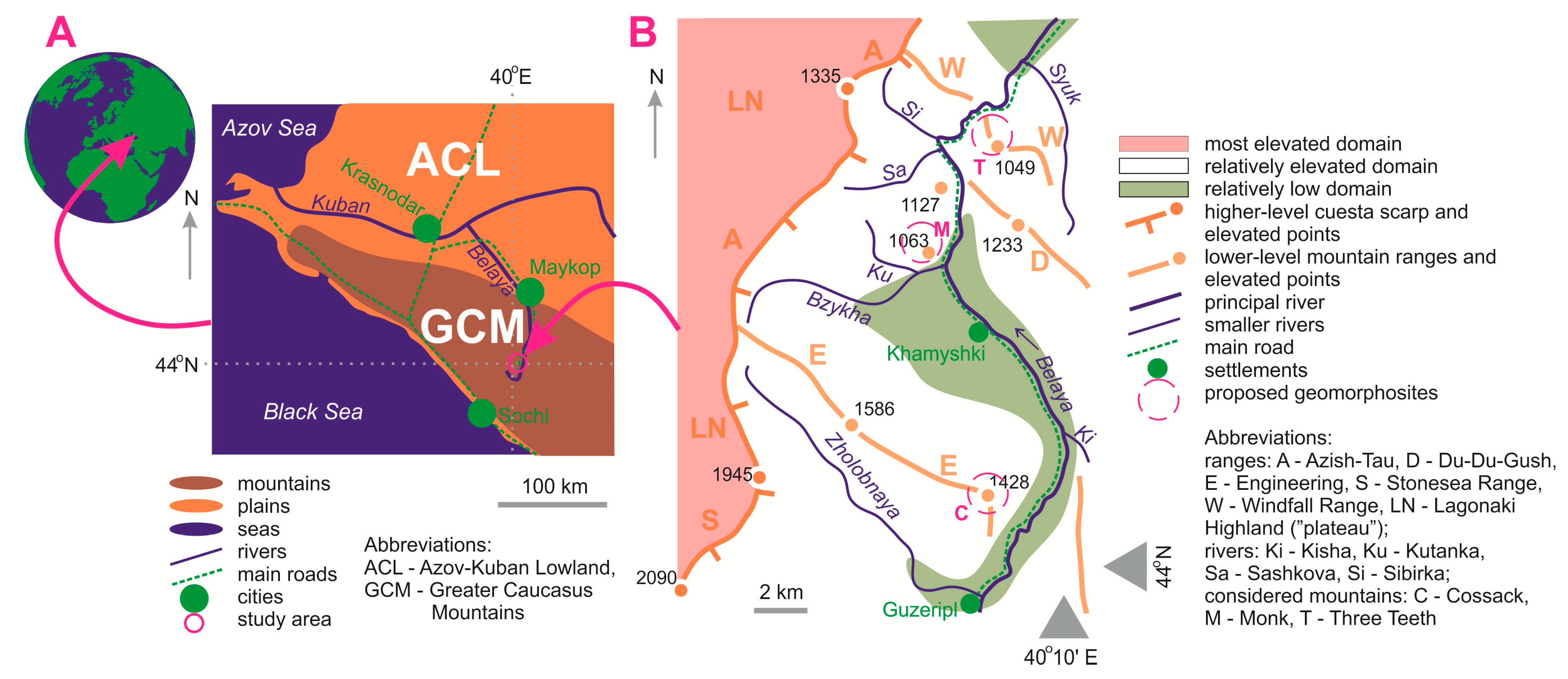
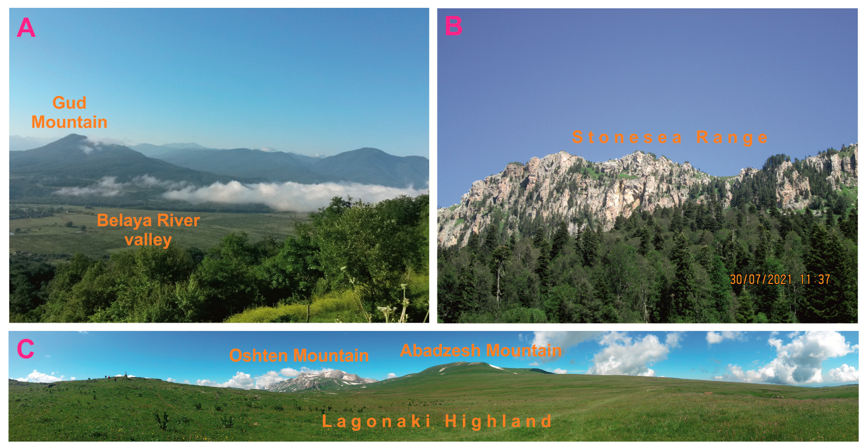
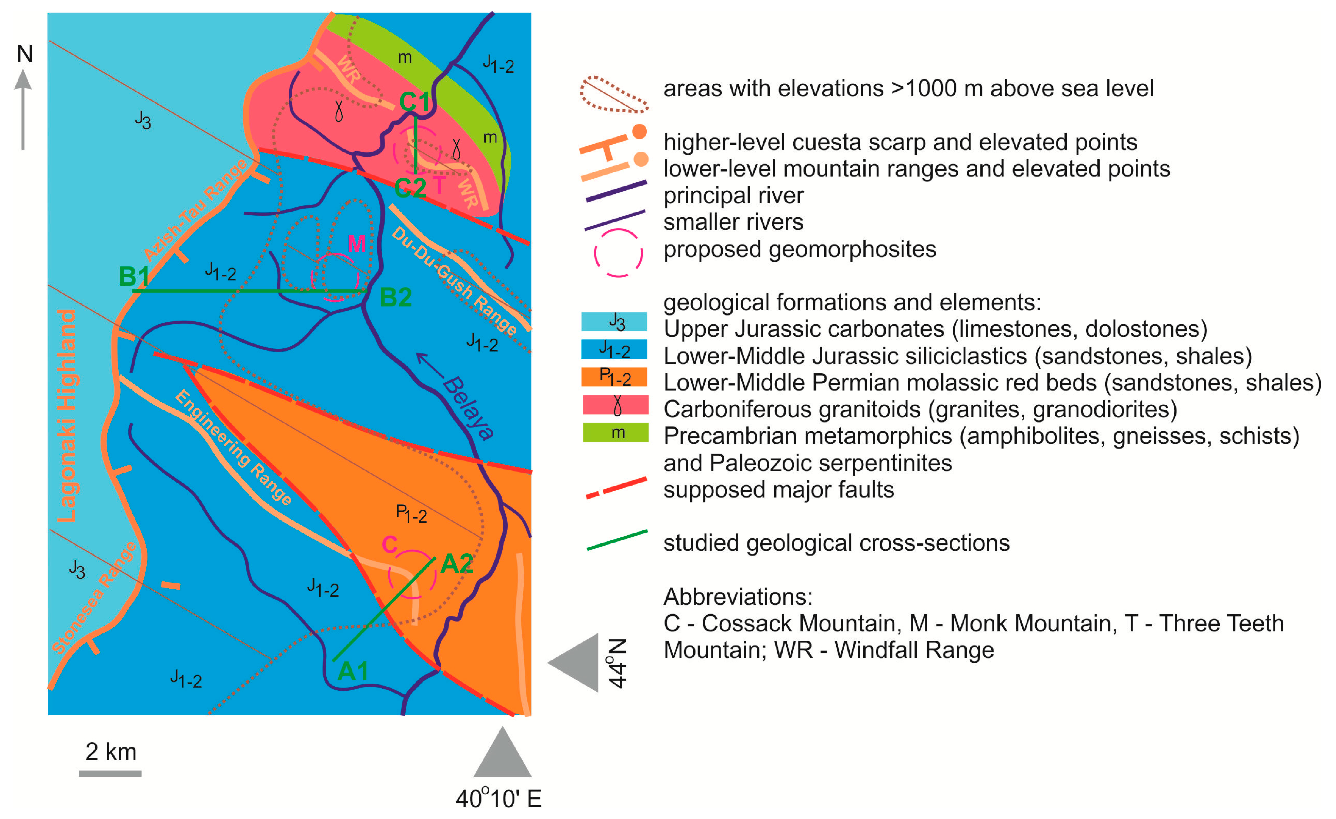
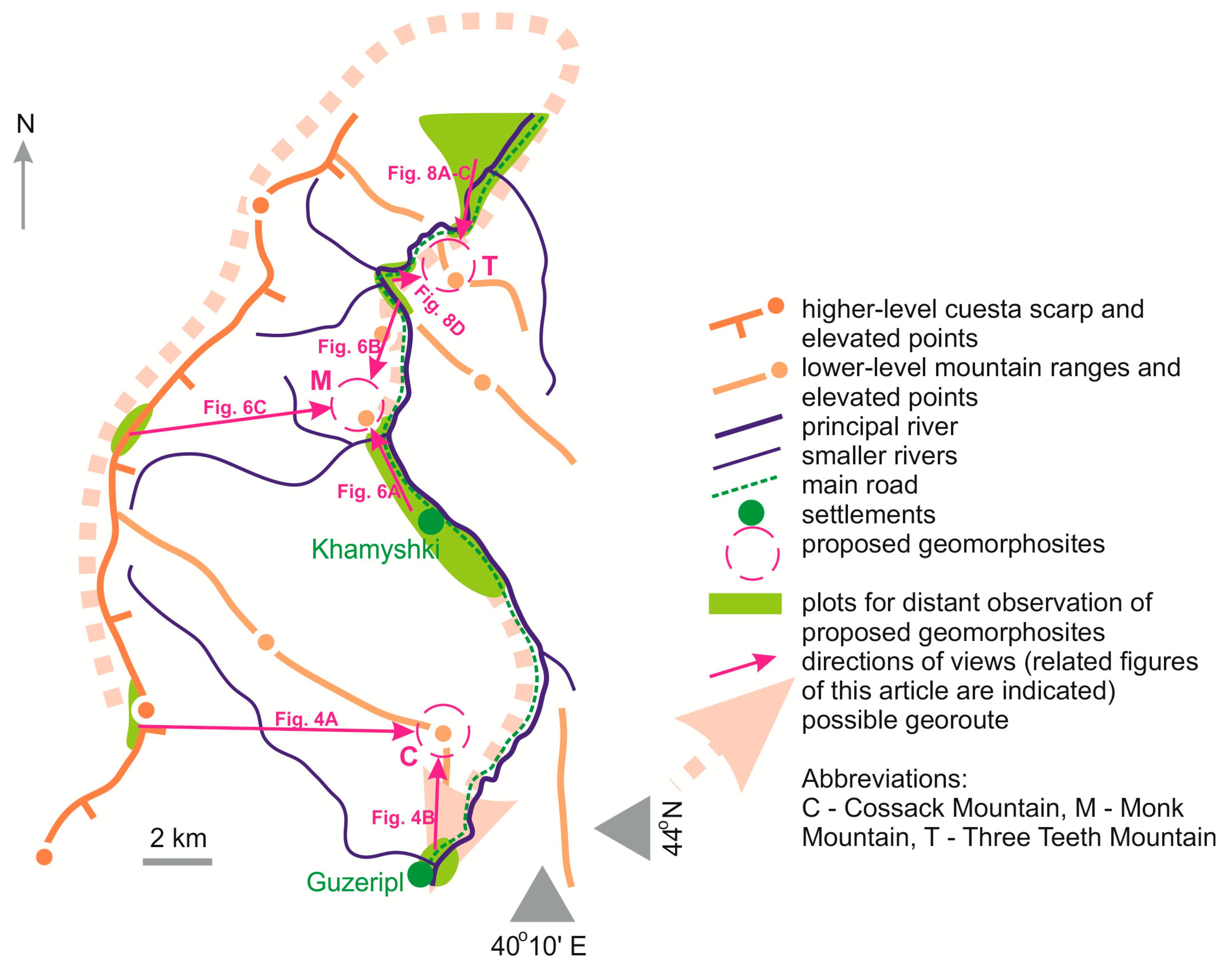
2. Study Area
3. Methodological Outline
4. Results
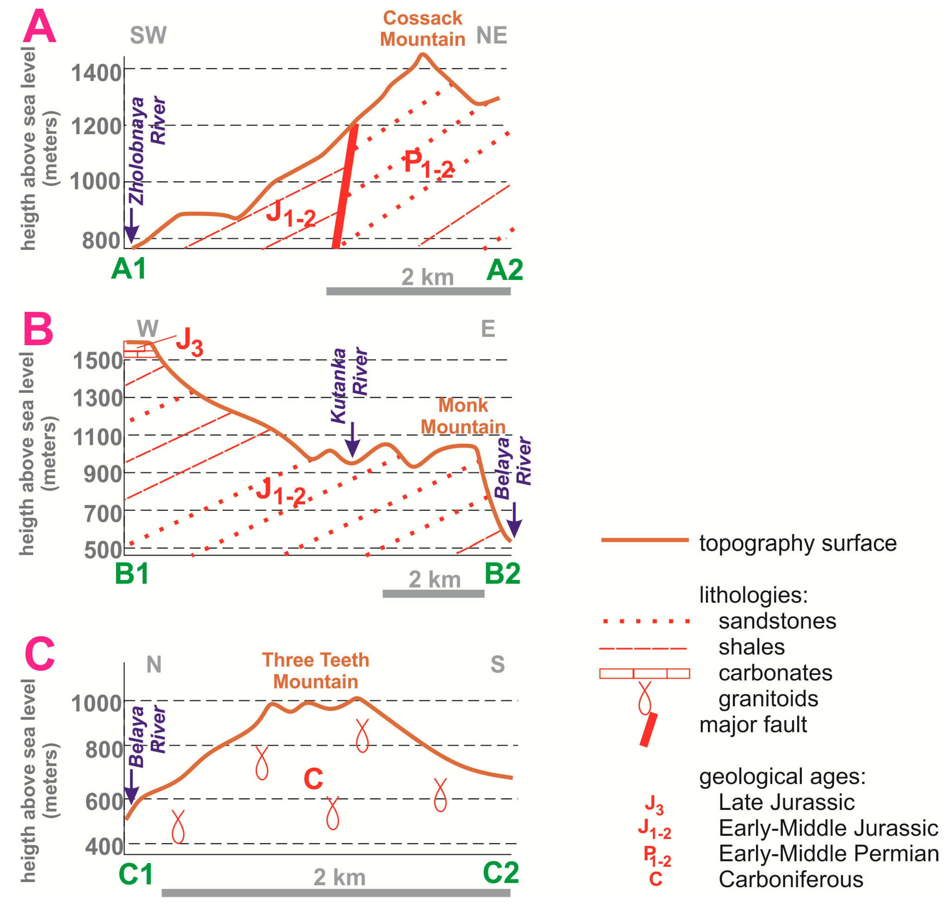
4.1. Description of Mountains
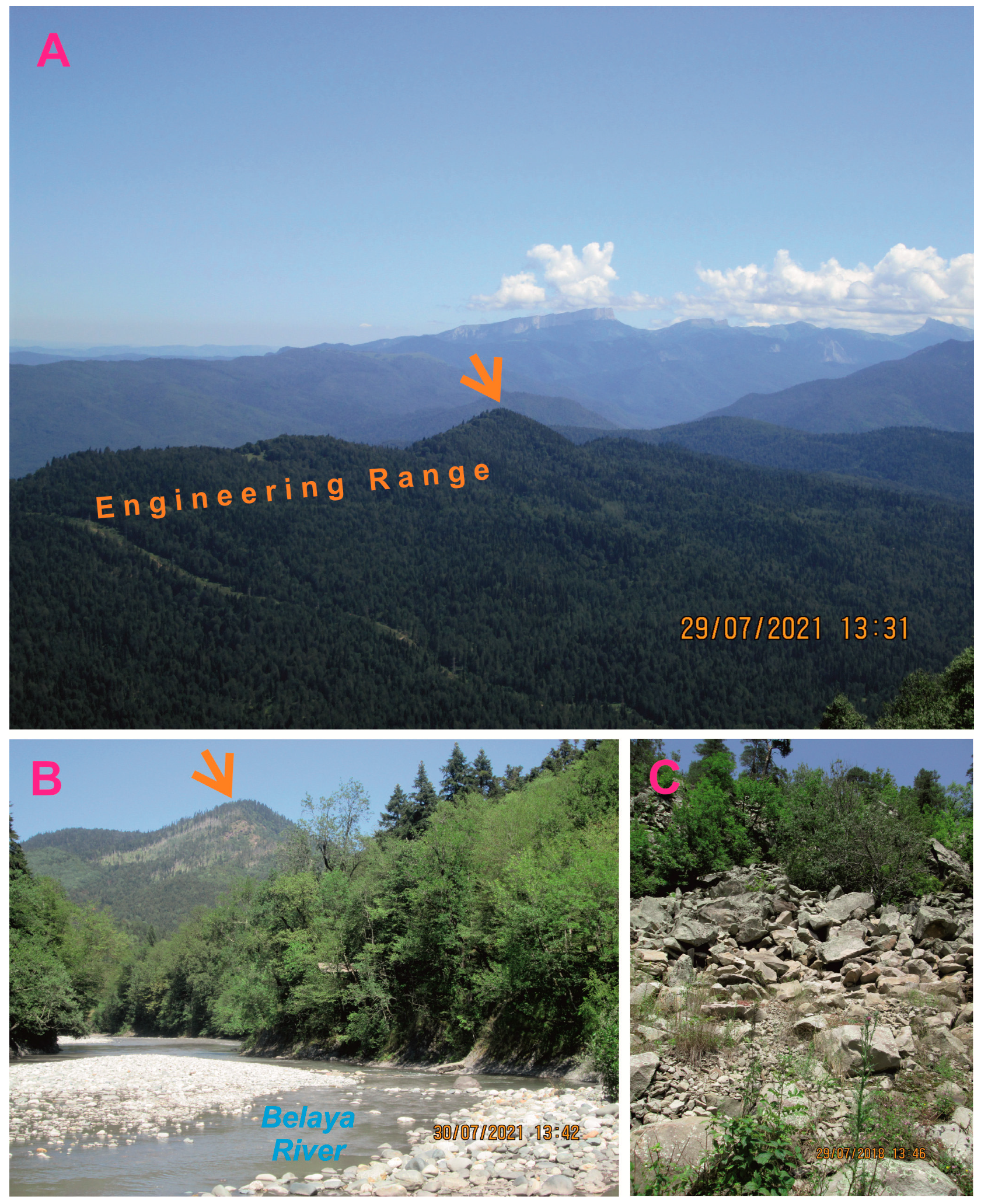
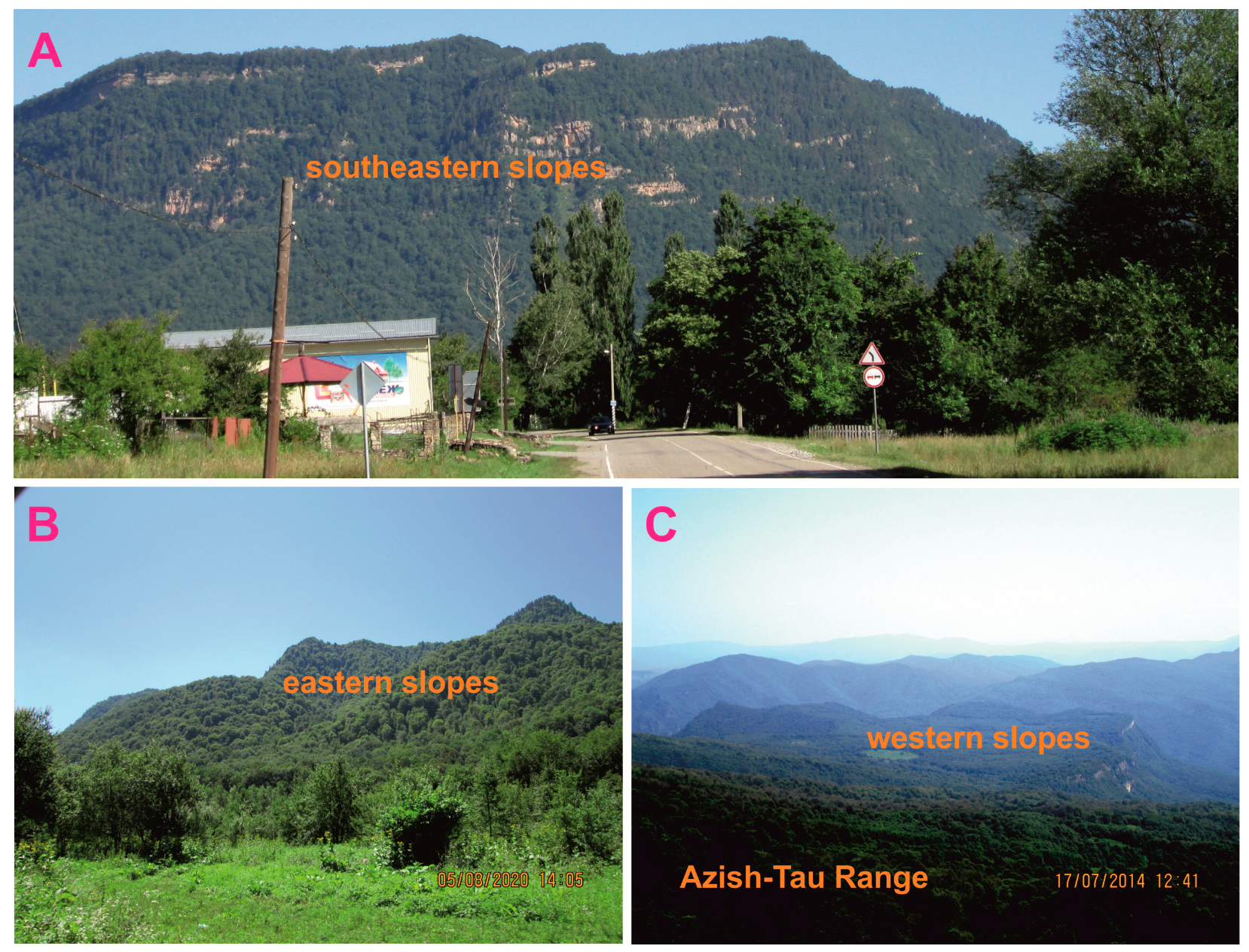
4.1.1. Cossack Mountain
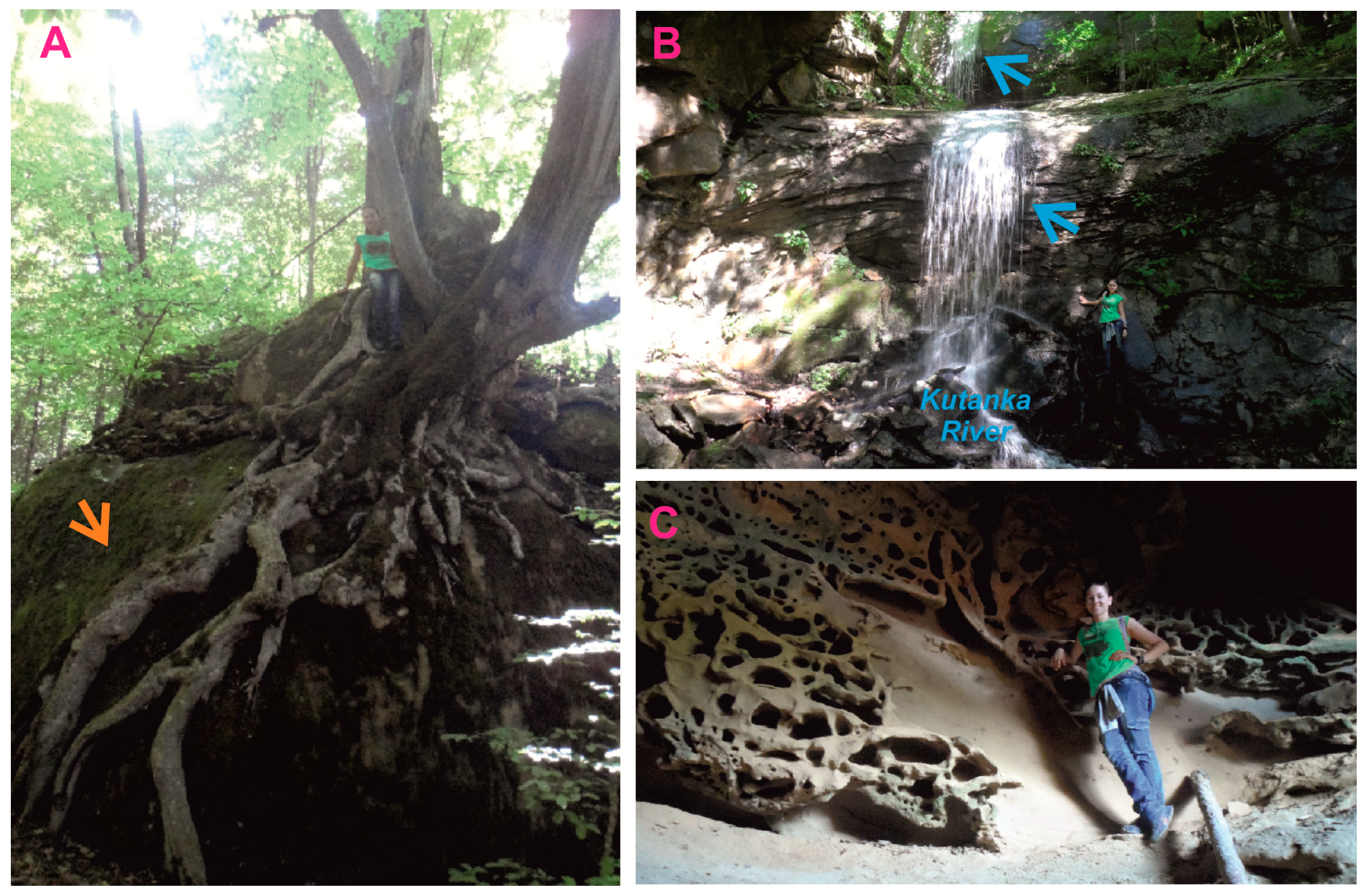
4.1.2. Monk Mountain
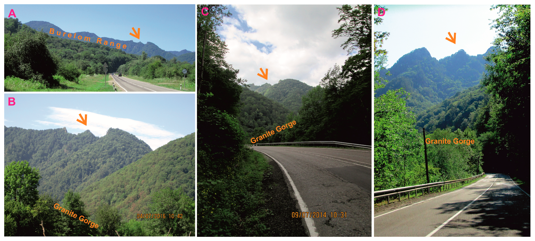
4.1.3. Three Teeth Mountain
4.2. Heritage Dimensions
4.3. Cultural Meanings
5. Discussion
5.1. Inferences and Practical Implications
5.2. Policy Implications
6. Conclusions
- (1)
- The Cossack, Monk, and Three Teeth mountains dominate the local landscapes and are interesting in regard to their morphology and geological setting that are reported descriptively (for instance, one can note the pyramid-like summit of the Cossack Mountain, table-like shape of the Monk Mountain, and three-peaked summit of the Three Teeth Mountain that were shaped by erosion in different geological settings);
- (2)
- As established by the “standardized”, semi-quantitative analysis of the basic geoheritage properties such as rank, number of geoheritage types, accessibility, vulnerability, need for interpretation, scientific, educational, touristic, and aesthetic importance, the proposed geomorphosites are more or less equal by their total heritage value, and they can be ranked locally, i.e., they are unique to Mountainous Adygeya;
- (3)
- The cultural meanings are reflected by the existing names of the analyzed geomorphosites (the related information also circulates via tourism-focused media) and related (in two cases) to their physical views, which can facilitate their touristic exploitation (importantly, the links between the names and the cultural environment can be traced easily);
- (4)
- The considered landforms constitute a resource that can be exploited for the purposes of education and tourism via a georoute connecting all plots for their distant observation;
- (5)
- The presence of geomorphosites with cultural meanings requires various modifications of the geoheritage policy.
Author Contributions
Funding
Data Availability Statement
Acknowledgments
Conflicts of Interest
References
- Gray, M. Case studies associated with the 10 major geodiversity-related topics. Philos. Trans. R. Soc. A Math. Phys. Eng. Sci. 2024, 382, 20230055. [Google Scholar] [CrossRef] [PubMed]
- Herrera-Franco, G.; Carrión-Mero, P.; Montalván-Burbano, N.; Caicedo-Potosí, J.; Berrezueta, E. Geoheritage and Geosites: A Bibliometric Analysis and Literature Review. Geosciences 2022, 12, 169. [Google Scholar] [CrossRef]
- Neto, K.; Henriques, M.H. Geoconservation in Africa: State of the art and future challenges. Gondwana Res. 2022, 110, 107–113. [Google Scholar] [CrossRef]
- Pescatore, E.; Bentivenga, M.; Giano, S.I. Geoheritage and Geoconservation: Some Remarks and Considerations. Sustainability 2023, 15, 5823. [Google Scholar] [CrossRef]
- Reynard, E.; Brilha, J. (Eds.) Geoheritage: Assessment, Protection, and Management; Elsevier: Amsterdam, The Netherlands, 2018; 450p. [Google Scholar]
- Urban, J.; Radwanek-Bąk, B.; Margielewski, W. Geoheritage Concept in a Context of Abiotic Ecosystem Services (Geosystem Services)—How to Argue the Geoconservation Better? Geoheritage 2022, 14, 54. [Google Scholar] [CrossRef]
- Zorlu, K.; Polat, S.; Yılmaz, A.; Dede, V. An integrated fuzzy-rough multi-criteria group decision-making model for quantitative assessment of geoheritage resources. Resour. Policy 2024, 90, 104773. [Google Scholar] [CrossRef]
- Coratza, P.; Giusti, C. Methodological proposal for the assessment of the scientific quality of geomorphosites. Alp. Mediterr. Quat. 2005, 18, 307–313. [Google Scholar]
- Erhartič, B. Geomorphosite assessment. Acta Geogr. Slov. 2010, 50, 295–319. [Google Scholar] [CrossRef]
- Kubalíková, L. Risk assessment on dynamic geomorphosites: A case study of selected abandoned pits in South-Moravian Region (Czech Republic). Geomorphology 2024, 458, 109249. [Google Scholar] [CrossRef]
- Migoń, P. Granite landscapes, geodiversity and geoheritage-global context. Heritage 2021, 4, 198–219. [Google Scholar] [CrossRef]
- Migoń, P. Diversity of added cultural values to geomorphosites–Evidence from sandstone landscapes of Central Europe. Geomorphology 2024, 451, 109086. [Google Scholar] [CrossRef]
- Mucivuna, V.C.; Reynard, E.; Garcia, M.G.M. Geomorphosites Assessment Methods: Comparative Analysis and Typology. Geoheritage 2019, 11, 1799–1815. [Google Scholar] [CrossRef]
- Panizza, M. Geomorphosites: Concepts, methods and examples of geomorphological survey. Chin. Sci. Bull. 2001, 46, 4–6. [Google Scholar] [CrossRef]
- Pelfini, M.; Bollati, I. Landforms and geomorphosites ongoing changes: Concepts and implications for geoheritage promotion. Quaest. Geogr. 2014, 33, 131–143. [Google Scholar] [CrossRef]
- Pereira, P.; Pereira, D. Methodological guidelines for geomorphosite assessment. Geomorphol. Relief Process. Environ. 2010, 2, 215–222. [Google Scholar] [CrossRef]
- Reynard, E.; Coratza, P. Geomorphosites and geodiversity: A new domain of research. Geogr. Helv. 2007, 62, 138–139. [Google Scholar] [CrossRef]
- Reynard, E.; Fontana, G.; Kozlik, L.; Pozza, C.S. A method for assessing «scientific» and «additional values» of geomorphosites. Geogr. Helv. 2007, 62, 148–158. [Google Scholar] [CrossRef]
- Ruiz-Pedrosa, R.M.; González-Amuchástegui, M.J.; Serrano, E. Geomorphosites as Geotouristic Resources: Assessment of Geomorphological Heritage for Local Development in the Río Lobos Natural Park. Land 2024, 13, 128. [Google Scholar] [CrossRef]
- Zorlu, K.; Dede, V. The Geomorphosite Assessment by Trapezoidal Bipolar Fuzzy Information-Based CRITIC-MABAC Method. Geoheritage 2023, 15, 94. [Google Scholar] [CrossRef]
- Bussard, J.; Reynard, E. Heritage Value and Stakeholders’ Perception of Four Geomorphological Landscapes in Southern Iceland. Geoheritage 2022, 14, 89. [Google Scholar] [CrossRef]
- Chlachula, J.; Mychko, E.V. Geoheritage of the Kaliningrad Region, SE Baltic Coast. Geoheritage 2023, 15, 132. [Google Scholar] [CrossRef]
- Del Monte, M.; Fredi, P.; Pica, A.; Vergari, F. Geosites within Rome City center (Italy): A mixture of cultural and geomorphological heritage. Geogr. Fis. Din. Quat. 2013, 36, 241–257. [Google Scholar]
- Necheş, I.-M. From geomorphosite evaluation to geotourism interpretation. Case study: The sphinx of Romania’s Southern Carpathians. Geoj. Tour. Geosites 2013, 12, 145–162. [Google Scholar]
- Niculiţă, M.; Mărgărint, M.C. Landslides and Fortified Settlements as Valuable Cultural Geomorphosites and Geoheritage Sites in the Moldavian Plateau, North-Eastern Romania. Geoheritage 2018, 10, 613–634. [Google Scholar] [CrossRef]
- Özdemir, M.A.; Kaymak, H.; Kulaksız, E.E. Inventory of Geomorphosites and Cultural Assets for the Development of Tourism in the Ayazini Region of the Mountainous Phrygia (Afyonkarahisar, Turkey). Geoheritage 2023, 15, 16. [Google Scholar] [CrossRef]
- Panizza, M.; Piacente, S. Geomorphosites: A bridge between scientific research, cultural integration and artistic suggestion. Alp. Mediterr. Quat. 2005, 18, 3–10. [Google Scholar]
- Quesada-Román, A.; Zangmo, G.T.; Pérez-Umaña, D. Geomorphosite Comparative Analysis in Costa Rica and Cameroon Volcanoes. Geoheritage 2022, 12, 90. [Google Scholar] [CrossRef]
- Brilha, J. Inventory and Quantitative Assessment of Geosites and Geodiversity Sites: A Review. Geoheritage 2016, 8, 119–134. [Google Scholar] [CrossRef]
- Ruban, D.A.; Mikhailenko, A.V.; Yashalova, N.N. Valuable geoheritage resources: Potential versus exploitation. Resour. Policy 2022, 77, 102665. [Google Scholar] [CrossRef]
- Bedanokov, M.K.; Chich, S.K.; Chetyz, D.Y.; Trepet, S.A.; Lebedev, S.A.; Kostianoy, A.G. Physicogeographical characteristics of the Republic of Adygea. Handb. Environ. Chem. 2020, 106, 19–55. [Google Scholar]
- Mikhailenko, A.V.; Ruban, D.A. Epikarst ‘ruining’ Jurassic reefs in the Lagonaki Highland, Western Caucasus. Int. J. Earth Sci. 2020, 109, 2773–2774. [Google Scholar] [CrossRef]
- Ruban, D.A. Mountain Ranges and Summits of the North-Eastern Periphery of the Lagonaki Highland; DGTU-Print: Rostov-on-Don, Russia, 2020; 95p. (In Russian) [Google Scholar]
- Davis, W.M. The Drainage of Cuestas. Proc. Geol. Assoc. 1899, 16, 75–93. [Google Scholar] [CrossRef]
- Duszyński, F.; Migoń, P.; Strzelecki, M.C. Escarpment retreat in sedimentary tablelands and cuesta landscapes–Landforms, mechanisms and patterns. Earth-Sci. Rev. 2019, 196, 102890. [Google Scholar] [CrossRef]
- Stefanuto, E.B.; Lupinacci, C.M.; Carvalho, F.; Francos, M.; Úbeda, X. An evaluation of erosion in cuesta relief: São Paulo State, Brazil. Geomorphology 2022, 398, 108049. [Google Scholar] [CrossRef]
- Lozovoy, S.P. Lagonaki Highland; Krasnodarskoe Knizhnoe Izdatel’stvo: Krasnodar, Russia, 1984; 160p. (In Russian) [Google Scholar]
- Forte, A.M.; Gutterman, K.R.; van Soest, M.C.; Gallagher, K. Building a Young Mountain Range: Insight Into the Growth of the Greater Caucasus Mountains From Detrital Zircon (U-Th)/He Thermochronology and 10Be Erosion Rates. Tectonics 2022, 41, e2021TC006900. [Google Scholar] [CrossRef]
- Nikishin, A.M.; Ershov, A.V.; Nikishin, V.A. Geological history of Western Caucasus and adjacent foredeeps based on analysis of the regional balanced section. Dokl. Earth Sci. 2010, 430, 155–157. [Google Scholar] [CrossRef]
- Van Hinsbergen, D.J.J.; Torsvik, T.H.; Schmid, S.M.; Matenco, L.C.; Maffione, M.; Vissers, R.L.M.; Gürer, D.; Spakman, W. Orogenic architecture of the Mediterranean region and kinematic reconstruction of its tectonic evolution since the Triassic. Gondwana Res. 2020, 81, 79–229. [Google Scholar]
- Alekseeva, A.E.; Ershov, A.V.; Linev, D.N. Numerical modeling of uplift and erosion at the Western Caucasus orogen in the Neogene-Quaternary. Mosc. Univ. Geol. Bull. 2014, 69, 213–218. [Google Scholar] [CrossRef]
- Yanvarev, G.S. Latest structure and geodynamics of Western Caucasus (based on decoding of satellite images). Geol. Geofiz. Yuga Ross. 2020, 10, 31–40. [Google Scholar]
- Bruschi, V.M.; Cendrero, A. Geosite evaluation; can we measure intangible values? Alp. Mediterr. Quat. 2005, 18, 293–306. [Google Scholar]
- Custódio, S.C.; Henriques, M.H.; Rosado-González, E.M.; Vaz, N.M.; Sá, A.A. Selected Geoheritage Resources of “Atlantic Geopark” Project (Central Portugal). Geosciences 2024, 14, 81. [Google Scholar] [CrossRef]
- Panizza, M. Outstanding Intrinsic and Extrinsic Values of the Geological Heritage of the Dolomites (Italy). Geoheritage 2018, 10, 607–612. [Google Scholar] [CrossRef]
- Pasquaré Mariotto, F.; Drymoni, K.; Bonali, F.L.; Tibaldi, A.; Corti, N.; Oppizzi, P. Geosite Assessment and Communication: A Review. Resources 2023, 12, 29. [Google Scholar] [CrossRef]
- Ruban, D.A.; Sallam, E.S.; Khater, T.M.; Ermolaev, V.A. Golden Triangle Geosites: Preliminary Geoheritage Assessment in a Geologically Rich Area of Eastern Egypt. Geoheritage 2021, 13, 54. [Google Scholar] [CrossRef]
- Wimbledon, W.A. The development of a methodology for the selection of British geological sites for conservation: Part 1. Mod. Geol. 1995, 20, 159–202. [Google Scholar]
- Gutak, J.M.; Ruban, D.A.; Ermolaev, V.A. Devonian geoheritage of Siberia: A case of the northwestern Kemerovo region of Russia. Heliyon 2023, 9, e13288. [Google Scholar] [CrossRef]
- Kirillova, K. A review of aesthetic research in tourism: Launching the Annual of Tourism Research Curated Collection on beauty and aesthetics in tourism. Ann. Tour. Res. 2023, 100, 103553. [Google Scholar] [CrossRef]
- Kirillova, K.; Fu, X.; Lehto, X.; Cai, L. What makes a destination beautiful? Dimensions of touristic aesthetic judgment. Tour. Manag. 2014, 42, 282–293. [Google Scholar] [CrossRef]
- Jonauskaite, D.; Abu-Akel, A.; Dael, N.; Oberfeld, D.; Abdel-Khalek, A.M.; Al-Rasheed, A.S.; Antonietti, J.-P.; Bogushevskaya, V.; Chamseddine, A.; Chkonia, E.; et al. Universal Patterns in Color-Emotion Associations Are Further Shaped by Linguistic and Geographic Proximity. Psychol. Sci. 2020, 31, 1245–1260. [Google Scholar] [CrossRef]
- Fedina, I.M. Archetype formation farmstead settlements Black Sea Cossacks at the end XVIII-mid XIX century. Vopr. Istor. 2021, 5–1, 182–189. [Google Scholar]
- Fedina, I.M. Military-Administrative and Demographic Aspects of the Kuban Cossack Settlements Formation on the Adagum Cordon Line in the Trans-Kuban (1860s). J. Front. Stud. 2023, 8, 154–168. [Google Scholar] [CrossRef]
- Stinson, M.J.; Grimwood, B.S.R. Defacing: Affect and situated knowledges within a rock climbing tourismscape. J. Sustain. Tour. 2022, 30, 1602–1620. [Google Scholar] [CrossRef]
- Van der Duim, R. Tourismscapes an actor-network perspective. Ann. Tour. Res. 2007, 34, 961–976. [Google Scholar] [CrossRef]
- Amoamo, M. Remoteness and Myth Making: Tourism Development on Pitcairn Island. Tour. Plan. Dev. 2011, 8, 1–19. [Google Scholar] [CrossRef]
- Razak, N.A.; Romle, A.R. Representation of native myths and legends and cultural values in the Malaysian tourism promotional brochures. Res. J. Appl. Sci. 2016, 11, 1379–1383. [Google Scholar]
- Robb, J.G. Tourism and legends archaeology of heritage. Ann. Tour. Res. 1998, 25, 579–596. [Google Scholar] [CrossRef]
- Komoo, I.; Azman, N.; Ahmad, N.; Ali, C.A.; Bukhari, A.M.M. An Integrated Geoproduct Development for Geotourism in Langkawi UNESCO Global Geopark: A Case Study of the Kubang Badak Biogeotrail. Geoheritage 2022, 14, 37. [Google Scholar] [CrossRef]
- Moreira, J.C.; Do Vale, T.F.; Burns, R.C. Fernando de Noronha archipelago (Brazil): A coastal geopark proposal to foster the local economy, tourism and sustainability. Water 2021, 13, 1586. [Google Scholar] [CrossRef]
- Ocelli Pinheiro, R.; Gentilini, S.; Giardino, M. A Framework for Geoconservation in Mining Landscapes: Opportunities for Geopark and GEOfood Approaches in Minas Gerais, Brazil. Resources 2023, 12, 20. [Google Scholar] [CrossRef]
- Reynard, E.; Coratza, P. Scientific research on geomorphosites. A review of the activities of the IAG working group on geomorphosites over the last twelve years. Geogr. Fis. Din. Quat. 2013, 36, 159–168. [Google Scholar]
- Rodrigues, J.; Neto de Carvalho, C.; Ramos, M.; Ramos, R.; Vinagre, A.; Vinagre, H. Geoproducts–Innovative development strategies in UNESCO Geoparks: Concept, implementation methodology, and case studies from Naturtejo Global Geopark, Portugal. Int. J. Geoheritage Parks 2021, 9, 108–128. [Google Scholar] [CrossRef]
- Bentivenga, M.; Palladino, G.; Prosser, G.; Guglielmi, P.; Geremia, F.; Laviano, A. A Geological Itinerary Through the Southern Apennine Thrust Belt (Basilicata—Southern Italy). Geoheritage 2017, 9, 1–17. [Google Scholar] [CrossRef]
- Kelley, D.; Salazar, R. Geosites in the Galápagos Islands Used for Geology Education Programs. Geoheritage 2017, 9, 351–358. [Google Scholar] [CrossRef]
- Morante-Carballo, F.; Domínguez-Cuesta, M.J.; Paz-Salas, N.; Malave-Hernandez, J.; Dueñas-Tovar, J.; Carrión-Mero, P. Evaluation of the potential of coastal cliffs as geosites for the promotion of geotourism. Geogr. Sustain. 2023, 4, 356–371. [Google Scholar] [CrossRef]
- Rapidah, M.S.; Mohamed, K.R.; Ali, C.A.; Leman, M.S.; Saidin, M. A geotouristic itinerary: A proposal for geotourism and archaeotourism development of Lenggong valley, Perak, Malaysia. Geoj. Tour. Geosites 2018, 22, 597–624. [Google Scholar]
- Wrede, V.; Mügge-Bartolović, V. GeoRoute Ruhr-a Network of Geotrails in the Ruhr Area National GeoPark, Germany. Geoheritage 2012, 4, 109–114. [Google Scholar] [CrossRef]
- Garau, E.; Pueyo-Ros, J.; Jimenez-Aceituno, A.; Peterson, G.; Norstrom, A.; Ribas Palom, A.; Vila-Subiros, J. Landscape features shape people’s perception of ecosystem service supply area. Ecosyst. Serv. 2023, 64, 101561. [Google Scholar] [CrossRef]
- Bruno, B.C.; Wallace, A. Interpretive Panels for Geoheritage Sites: Guidelines for Design and Evaluation. Geoheritage 2019, 11, 1315–1323. [Google Scholar] [CrossRef]
- Moreira, J.C. Interpretative Panels About the Geological Heritage-a Case Study at the Iguassu Falls National Park (Brazil). Geoheritage 2012, 4, 127–137. [Google Scholar] [CrossRef]
- Ahmadi, A.; Taghian, A.; Yamani, M.; Mousavi, S.H. Assessing and determining the policies of strategic management of geomorphotourism in Awramanat region in line with the geotourism development of the region. Adv. Environ. Biol. 2015, 9, 585–595. [Google Scholar]
- Bétard, F.; Rouget, I.; Hobléa, F.; Aubron, I.; Billet, P.; Egoroff, G.; Giusti, C.; Poiraud, A.; Portal, C. Geoconservation in France: History, Key Policies, and Current Tools. Geoheritage 2023, 15, 52. [Google Scholar] [CrossRef]
- De Lima, J.T.M.; de Souza Carvalho, I. Curatorial Management on Geological and Paleontological Collections in Brazil: Integrative Policies for the Ex Situ Geoheritage. Geoheritage 2024, 16, 16. [Google Scholar] [CrossRef]
- Lima, E.A.; Lima, A.F.; Brilha, J.; Calado, H.; Nunes, J.C. Integration of the geoheritage management in environmental and land-use policies. Rend. Online Soc. Geol. Ital. 2013, 28, 102–105. [Google Scholar]
- Prosser, C.D. The history of geoconservation in England: Legislative and policy milestones. Geol. Soc. Spec. Publ. 2008, 300, 113–122. [Google Scholar] [CrossRef]

| Criteria | Explanation | Notes |
|---|---|---|
| Rank | Relative uniqueness (rarity) of a site, which depends on the abundance on analogue sites in a given territory | Can be global (world-scale), national (federal), regional (provincial), and local |
| Number of geoheritage types | Geoheritage type reflects attribution of a given feature to a particular class of phenomena | For geomorphosites, the geomorphological type always exists and often dominates; however, it may co-exist with some other type(s) such as mineralogical, palaeontological, sedimentary, or other types (see nomenclature of types in [30]). |
| Accessibility | How easy is to reach a site | Depends on physical remoteness from roads and settlements, transport infrastructure, wilderness, etc. |
| Vulnerability | How easy can a site loose (partly or fully) its value due to natural or anthropogenic influences | Depends on activity (actual or potential) of processes (natural or anthropogenic) affecting a site |
| Need for interpretation | How easy to realize essence of a site | Depends on degree of professional background required for the proper understanding of a site |
| Scientific importance | Utility for geoscience (also geomorphological) research | Research/education/tourism initiatives can be either locally or internationally important |
| Educational importance | Utility for geoscience (also geomorphological) learning by university students and schoolchildren | |
| Touristic importance | Utility for geotourism | |
| Aesthetic importance | Presence of features or properties that associate with the common criteria of people’s judgments of beauty | For geomorphosites, the most evident aesthetic properties are size and shape; nonetheless, many other aesthetic properties should not be ignored |
| Criteria and Scores (Scores Are Indicated for Each Grade) | Geomorphosites | ||
|---|---|---|---|
| Cossack | Monk | Three Teeth | |
| Rank: global (+500), national (+250), regional (+100), local (+50) | +50 | +50 | +50 |
| Number of geoheritage types: >10 (+50), 4–10 (+25), 2–3 (+10), 1 (0) | +10 | +25 | +10 |
| Accessibility: easy in populated area (+25), easy in remote area (0), difficult (−25) | −25 | −25 | −25 |
| Vulnerability: no danger (+25), potential danger (0), partly damaged (−25), fully destroyed (−50) | +25 | −25 | 0 |
| Need for interpretation: absent (+25), basic geological knowledge required (0), professional geological knowledge required (−10), scientific analysis required (−25) | +25 | +25 | 0 |
| Scientific importance: international (+25), local (0) | 0 | 0 | 0 |
| Educational importance: international (+25), local (0) | 0 | 0 | 0 |
| Touristic importance: international (+25), local (0) | 0 | 0 | 0 |
| Aesthetic importance: high (+50), medium (+25), low (0) | 0 | +25 | +50 |
| TOTAL SCORES | 85 | 75 | 85 |
| Geomorphosite | Cultural Interpretation | Sources (All Are in Russian and All Were Accessed on 15 May 2024) |
|---|---|---|
| Cossack | Indirect: the history of the Cossack removal to the Western Caucasus | https://www.kavkazzapoved.ru/news/guzeripl-nemnogo-istorii |
| Monk | Direct: attribution of the slope’s peculiarities to a person’s face with legendary explanations | http://armola.ru/gory/18/gora-monah-hamyshki.html |
| https://gornaya-derevnya.ru/rest/attractions/place/gora-monah/ | ||
| http://budetinteresno.info/holms/monah_skala.htm | ||
| Three Teeth | Direct: similarity of three summits of the mountain to three teeth and Neptune’s trident; sometimes, not three, but five “teeth” are mentioned | http://vetert.ru/rossiya/adygeya/sights/253-gora-trezubec.php |
| https://lagonaki.ru/dostoprimechatelnosti/gora-trezubecz-v-adygee/ | ||
| https://krasnodar-turist.ru/marshruty/adygeya/trezubec/ |
Disclaimer/Publisher’s Note: The statements, opinions and data contained in all publications are solely those of the individual author(s) and contributor(s) and not of MDPI and/or the editor(s). MDPI and/or the editor(s) disclaim responsibility for any injury to people or property resulting from any ideas, methods, instructions or products referred to in the content. |
© 2024 by the authors. Licensee MDPI, Basel, Switzerland. This article is an open access article distributed under the terms and conditions of the Creative Commons Attribution (CC BY) license (https://creativecommons.org/licenses/by/4.0/).
Share and Cite
Mikhailenko, A.V.; Ruban, D.A.; Ermolaev, V.A. Three Landscape-Dominating Mountains of the Western Caucasus: Case Studies of Local Heritage and Cultural Inferences. Heritage 2024, 7, 4227-4248. https://doi.org/10.3390/heritage7080199
Mikhailenko AV, Ruban DA, Ermolaev VA. Three Landscape-Dominating Mountains of the Western Caucasus: Case Studies of Local Heritage and Cultural Inferences. Heritage. 2024; 7(8):4227-4248. https://doi.org/10.3390/heritage7080199
Chicago/Turabian StyleMikhailenko, Anna V., Dmitry A. Ruban, and Vladimir A. Ermolaev. 2024. "Three Landscape-Dominating Mountains of the Western Caucasus: Case Studies of Local Heritage and Cultural Inferences" Heritage 7, no. 8: 4227-4248. https://doi.org/10.3390/heritage7080199
APA StyleMikhailenko, A. V., Ruban, D. A., & Ermolaev, V. A. (2024). Three Landscape-Dominating Mountains of the Western Caucasus: Case Studies of Local Heritage and Cultural Inferences. Heritage, 7(8), 4227-4248. https://doi.org/10.3390/heritage7080199