Abstract
This paper presents the results of the analyses conducted on 46 stone samples collected from Roman buildings in Oderzo, a small town located in the heart of the eastern Venetian plain (29 samples), and from architectural artifacts preserved at the local archeological museum “Eno Bellis” (17 samples). The aim of this study is to identify the types and provenance of the stones used for architectural purposes in Roman times in the city of Oderzo (ancient Opitergium). All the materials were petrographically characterized using a multi-analytical approach, including polarized light optical microscopy (PLM). Moreover, volcanic rock samples were analyzed via X-ray fluorescence (XRF) and quantitative phase analysis via X-Ray powder diffraction (QPA-XRPD) to obtain more detailed mineralogical and geochemical characterizations. These methods proved valuable for better determining the provenance of the materials. The results allowed us to determine the quarrying areas that Opitergium mostly relied upon in antiquity for sourcing building materials, as well as the stone trade networks in which the city was integrated. Preliminary findings indicate a higher frequency of stones sourced from outcrops along the Prealpine Arc of north-eastern Italy and Istria, including Aurisina limestone (Trieste Karst), and micritic limestones possibly quarried in the Istrian peninsula for architectural artifacts. Conversely, lithotypes from north-western Prealps appear to have been used less frequently. The volcanic rock samples were entirely sourced from various quarry sites in the Euganean Volcanic District in the Veneto region.
1. Introduction
1.1. Objectives of the Research
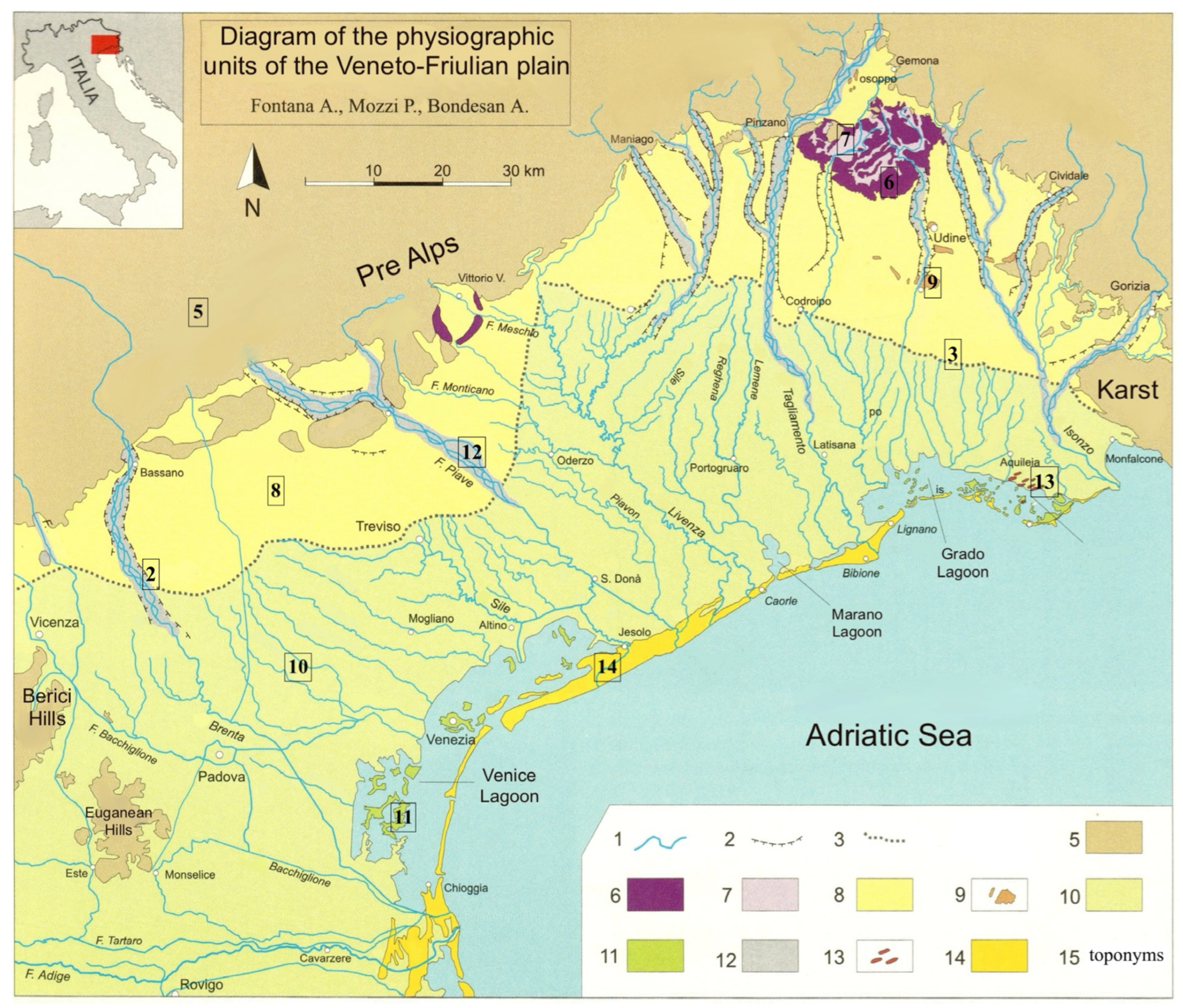
In the framework of a broader research project on the Roman architecture of Regio X (Venetia et Histria) conducted over the past few years by the Department of Cultural Heritage in collaboration with the Department of Geosciences of the University of Padova [1,2,3,4,5,6], this study aims to determine the provenance of the stones used in the city of Oderzo (Opitergium) for architectural purposes during the Roman Age and their trade network. To do so, we collected and analyzed 46 stone samples from two of the main archeological areas in the city (the forum and the so called “Ex Carceri” area), as well as from architectural elements preserved in the archeological museum “Eno Bellis” in Oderzo. This study focuses on the use of local stones. The region (Figure 1) is, in fact, naturally rich in resources, including stones, which have been widely exploited since pre-Roman times. These primarily consist of sedimentary rocks, specifically limestones, which outcrop in the Berici Hills, the Venetian Prealps, the Triestine Karst, and the Istrian peninsula [1,7,8]. Additionally, the main outcrop for the sourcing of volcanic rock materials consists of the Oligocene Euganean volcanic district in the Veneto region [9]. Both sedimentary and volcanic rocks were extensively used in Roman times for constructing structures, infrastructure, and artifacts, as well as for general building purposes.
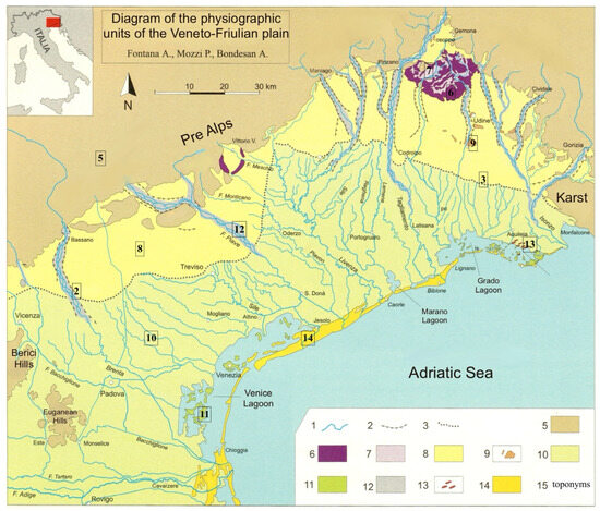
Figure 1.
Diagram of the physiographic units of the Veneto–Friulan plain: (1) hydrography; (2) river slopes; (3) springs line; (5) Euganean Hills, Berici Hills, Prealps; (6) Morainic ridges of the Piave and Tagliamento river basins; (7) intermorainic depressions; (8) upper plain; (9) low plain; (10) tectonic terraces; (11) lagoon islands; (12) gravel riverbeds; (13) sand uplands; (14) delta coastal system; (15) toponyms (modified from [10]).
An in-depth scientific study of the quarrying and trading strategies, along with the data derived from it, has considerable informational potential. In fact, identifying the quarrying basins of origin makes it possible to reconstruct the trade routes that shaped the region during Roman times and to identify possible preferential relationships with certain quarries, which could indicate close economic ties between the builders, the quarry workers, and those responsible for transporting the material to the site. Reconstructing such dynamics is crucial as the quarrying phase and, in particular, the transportation of the stone involved considerable costs that undoubtedly weighed heavily on the builders’ financial budgets.
1.2. State of the Art
For a long time, research on Roman architecture has focused almost exclusively on the formal, stylistic, and chronological aspects of ancient construction. In many studies conducted between the 19th and 20th centuries, the meticulous analysis of these stylistic aspects was not matched by equal attention to the construction materials and techniques used in ancient buildings, nor to the related dynamics of supply, processing, and trade of natural resources, including stone materials.
The study of stone resources and their use in Roman architecture is a relatively recent topic. In regards to Northern Italy, the first to propose a review of the quarrying basins in the Veneto region, as well as a distribution map of the different lithotypes used in urban centers of the Roman Age, is A. Buonopane [11]. In more recent years, the University of Padua started a research project on the stone resources of the X Regio, investigating the dynamics of their extraction, circulation, and use. The research has, in some cases, focused on specific urban centers and related territories, such as Aquileia [1] and Verona [12], where ancient buildings have been examined through in-depth studies which included archaeometric analysis on stone materials. In addition to these synthesis works, several contributions have focused on the region’s stone resources, emphasizing different perspectives, such as the trading and diffusion of stone types [2,3,4], provenance determination studies [6,13,14,15,16,17,18,19], and transport routes and commercial dynamics of stone materials [20,21].
Despite such remarkable progress, the implementation of an interdisciplinary approach—specifically, a multi-analytical protocol that includes petrographic and archaeometric analyses—remains rare in the study of stone materials used in the Roman architecture of the region.
2. History and Architecture of Roman Oderzo
Located in the heart of the Eastern Venetian plain, Oderzo stands on a hillock to the right of a wide bend of the Monticano river. The area is bordered to the west by the Piave river and to the east by the Livenza river [22,23]. The site’s advantageous location, relatively close to the coastline and accessible in ancient times via the Navisego Vecchio-Piavon and Monticano rivers [24], is undoubtedly one of the reasons for the settlement’s longevity. Its development spans over three millennia, beginning between the 10th and 9th centuries BC, where it served as an important crossroad and communication hub connecting eastern Veneto, the Alpine region, and the Euganean area. During this period, the settlement occupied the top of the hillock and consisted of a cluster of huts. The crossroad nature of the site facilitated the early development of a complex road network, whose main routes continued to be used even in Roman times [25].
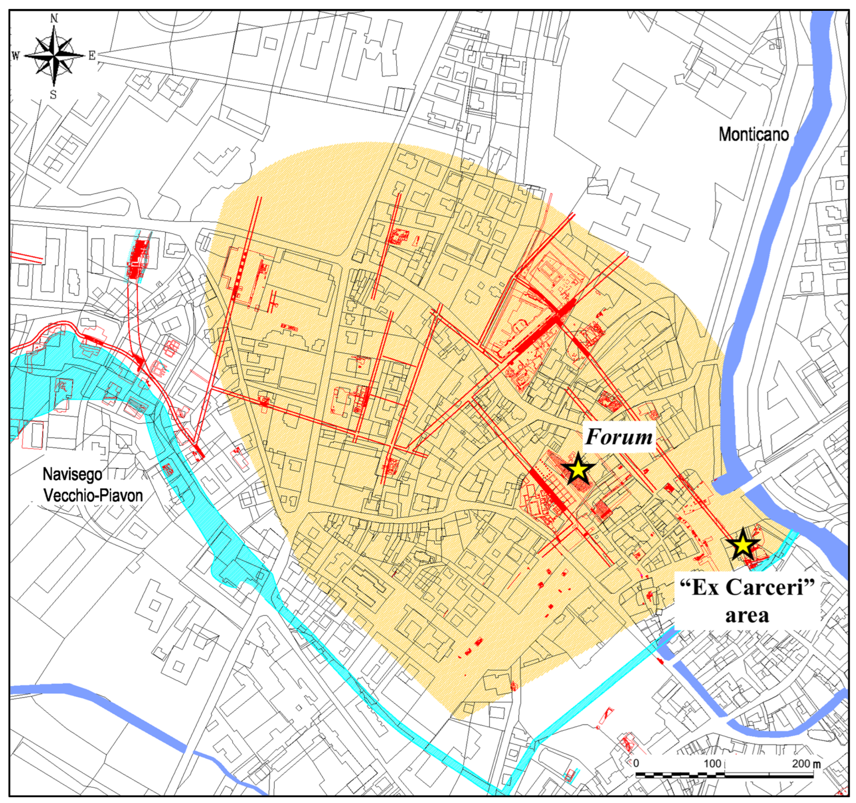
The adaptation of the settlement layout to Roman urban standards occurred relatively quickly (Figure 2). By the late 2nd century to early 1st century BC, the city was already provided with a forum square. This period of architectural expansion was further enhanced by the nearby Via Postumia, constructed in 148 BC by the consul Spurius Postumius Albinus [26].
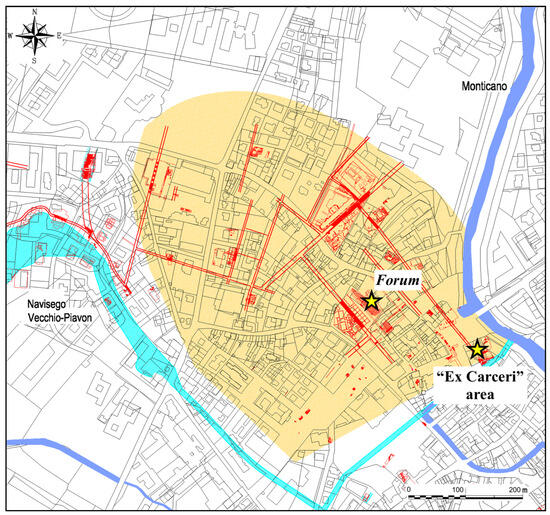
Figure 2.
Map of Roman Opitergium, with an indication of the archeological areas analyzed in this study [modified from [25]] (blue = rivers; yellow = ancient city area; red = ancient structures and infrastructure).
In the second half of the 1st century BC, when the region was granted Roman citizenship, the newly established municipium Opitergium underwent an extensive urban restructuring plan that continued throughout the 1st century AD. This project led to the construction of impressive public architectural complexes, including a monumental square (forum) [27], a bath building [28], a temple [29], and many prestigious houses (domus) [25,30,31]. A dense network of infrastructure, including paved roads [32], a river dock [33], and city walls [34], also date to this period. During this time, as this study shows, the import of stone material increased. The stone used in this phase of reconstruction and renovation came from quarries throughout the region, including those further away from the city.
The settlement’s development eventually slowed down due to the looming barbarian invasion, which threatened the city as early as the 2nd century AD, notably with the incursions of the Quadi and Marcomanni. This also led to a decrease in the import of stone material, as evidenced by the rare stone samples taken from buildings dated to this period and analyzed in this research.
A mosaic floor depicting hunting scenes [35], dated to the 3rd century AD, indicates a brief revival of residential construction during the Late Antique period just before a decline in the following centuries. At this stage, there was a modest increase in stone imports, particularly from the nearby Prealps.
Our knowledge of the Late Antique and Medieval phases of the city comes from the archeological evidence found in the so-called Ex Carceri area [36]. In the 7th century AD, a new defense wall was constructed using the remnants of Roman structures (including a section of the Augustan walls, a paved road, and a city gate), reusing numerous stone elements from Roman funerary contexts, such as cylindrical altars, decorated stelae, and an inscribed statue base [37]. The need for robust fortifications came from the Lombard invasion that led to the destruction of the city in 667, as recounted by Paolo Diacono in the Historia Langobardorum (IV, 38, 45).
Despite the city’s destruction, occupation of the site continued, and new restructuring projects soon began. A keep, built on the southwestern corner of the 7th century AD wall using large blocks of Euganean trachyte and limestone taken from the ruins of monumental buildings of Roman Opitergium, was realized between the 8th and 9th centuries [38]. These structures were later utilized as foundations for new buildings and infrastructure, including a tower house, a new city wall, and ultimately, the Medieval castle. The prison tower, which lends its name to the area, was erected in 1797 on the castle’s ruins.
3. Materials and Methods
3.1. Sampling
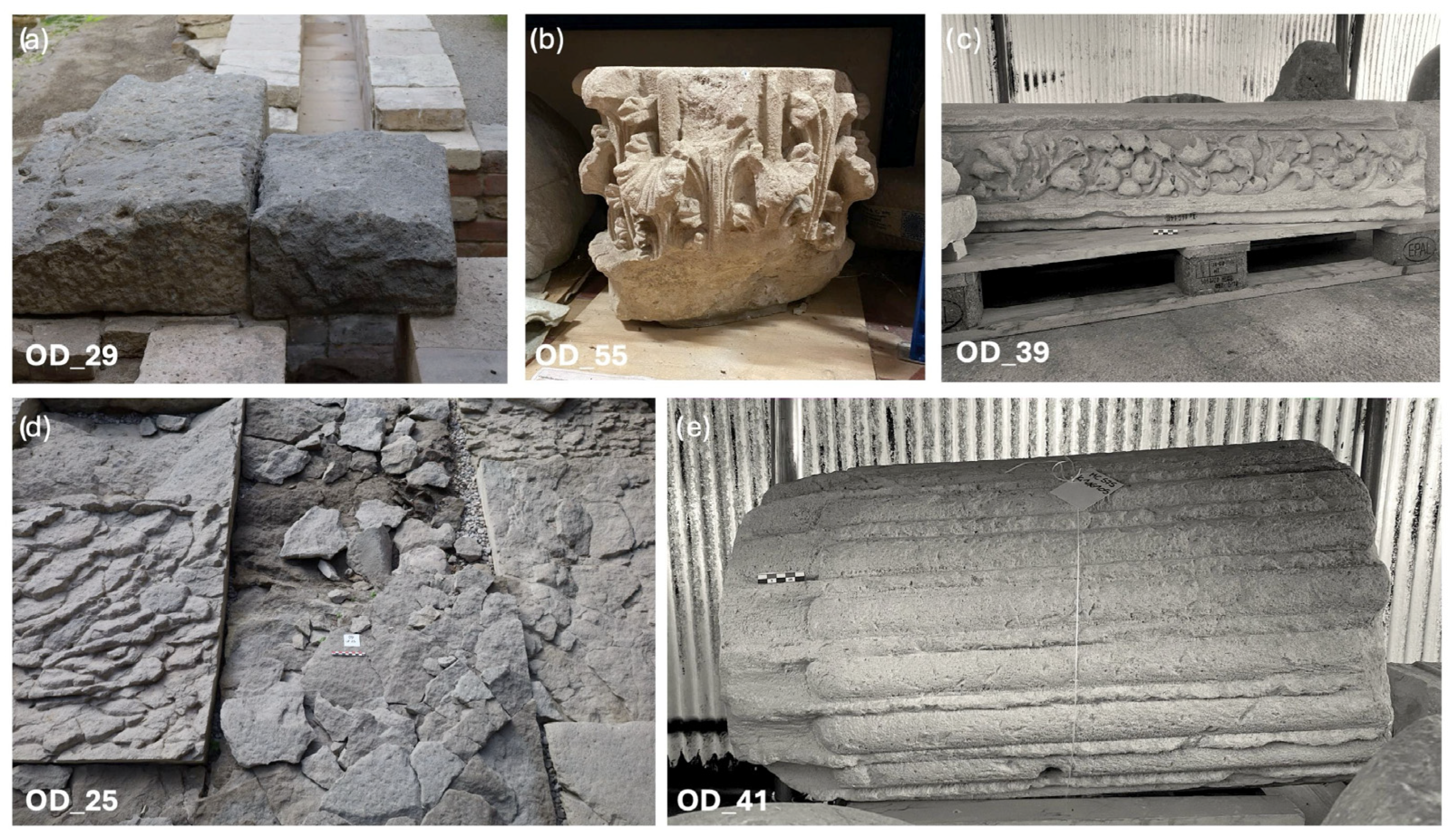
For the purpose of this research, 46 stone samples were taken, 29 from structures preserved in the archeological areas of the forum and the Ex Carceri and 17 from stone artifacts preserved in the Archeological Museum “Eno Bellis” in Oderzo (Figure 3). In particular, 16 pavement elements, with 8 from the cavaedium of the city gate (OD_01; OD_02; OD_03; OD_04; OD_05; OD_06; OD_09; OD_10), 1 from a paved road (OD_11), 1 from the pavement of the basilica (OD_19), 6 from the forum square (OD_25; OD_27; OD_28; OD_31; OD_33; OD_35); 2 small pillars (OD_13; OD_14); 1 drainage lid (OD_29); 1 drainage filter (OD_18); 3 thresholds, with 2 from the cavaedium of the city gate (OD_07; OD_12) and 1 from the basilica (OD_20); and 23 architectural elements, with 1 acroterium (OD_52), 2 architraves (OD_45; OD_51), 5 ashlars (OD_08; OD_15; OD_16; OD_17; OD_36), 4 capitals (OD_43; OD_49; OD_54; OD_55), 1 column base (OD_37), 3 columns (OD_38; OD_41; OD_50), 5 cornices (OD_22; OD_23; OD_44; OD_46; OD_53), 1 frieze fragment (OD_39), and 1 fragment of semi-column (OD_42). The operation was carried out via mechanical removal, using a chisel, of centimeter-sized fragments of stone material. Where possible, elements characterized with pre-existing gaps were favored, which allowed for the easy identification and removal of the material, as well as minimal impact on structures. All samples came from structures and artifacts dated to Roman times [39]. In buildings with more than one construction phase, when possible, samples were taken from structures of all the different phases in order to identify elements of either continuity or discontinuity in the selection and use of stone materials.
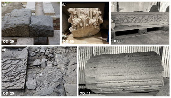
Figure 3.
Selection of archeological structures and artifacts sampled in the archeological areas and in the archeological museum “Eno Bellis” in Oderzo: (a) OD_19 = drainage lid; (b) OD_55 = capital; (c) OD_39 = decorated architrave; (d) OD_25 = paving slab; (e) OD_41 = column.
3.2. Analythical Method
To gather as much information as possible from the stone samples, we applied an analytical protocol that was already established [40]; it involved characterizing different stone types using various archaeometric approaches, including textural and microfaunal analyses through optical microscopy and geochemical analyses. The results are then compared with established data on the petrographic and geochemical signatures of quarry sites to determine the likely provenance of the rock samples.
The preliminary macroscopic identification allowed us to classify the samples into two groups: one consisting of 30 sedimentary rock samples and the other of 16 volcanic rock samples, predominantly Euganean trachyte. Subsequently, the samples underwent two different characterization protocols. Both sedimentary rocks, primarily carbonate, and volcanic rock samples were first analyzed petrographically using PLM to identify their petrofacies, which are useful for determining their geological formation.
Moreover, a more detailed analytical approach was adopted for volcanic rocks, which allowed us to identify the specific quarry site for most of the samples.
The volcanic rock samples were therefore characterized from a geochemical point of view using XRF (X-ray fluorescence) analysis. The quantitative data of major and trace elements thus obtained were then compared with databases of geological samples taken from known quarries in the Euganean area [41] to assess correlations with the quarry basins. Both the geological quarry samples and archeological ones were analyzed via XRF by adopting the same analytical protocol as reported in [42]. Reference samples constitute the geochemical databases implemented by the Department of Cultural Heritage and the Department of Geosciences of the University of Padua, comprising modern geological samples directly collected from Euganean quarries coupled with archeological samples (analyzed in [40] and previous studies) unequivocally attributed to quarry outcrops. The samples were categorized in groups according to their chemical composition via cluster analyses and then compared in bivariate scatterplots to reference samples in order to better identify their geological provenance from Euganean volcanic outcrops using a selection of discriminant chemical elements selected among major elements, specifically REE and HFSE. For further confirmation, the data obtained were analyzed using discriminant analysis, with the same pattern of major and trace elements used to produce the scatterplots and PCA/cluster analyses as the discriminant variables. The archeological samples were again compared with 218 samples of known origin. Discriminant analysis (DA), using the tools available in Statgraphics Centurion Pro 19, enabled the probabilistic identification of quarry sites by providing percentage-based likelihoods of origin. When the probability for a primary site did not reach 100% (unequivocal attribution), a secondary site was also suggested on a probabilistic basis. This approach, frequently used by our team for volcanic rock identification [6,40], provides robust probabilistic provenance attribution based on geochemical data. Finally, a coherent selection of samples was subjected to QPA-XRPD (X-ray powder diffraction) analysis to observe possible discrimination markers based on the bulk mineralogy of the samples.
3.3. Analytical Equipment
All analyses were conducted using equipment located at the Department of Geosciences, University of Padova.
The PLM-TL (transmitted light) analyses were performed on rock samples prepared on 30 μm thin sections using a Leica DM750 P microscope equipped with an integrated FLEXACAM I5 digital camera (Leica Geosystems, Heerbrugg, Switzerland).
The XRF analyses were performed on volcanic rock samples with a WDS Panalytical Zetium sequential spectrometer (Malvern Panalytical, Malvern, UK), operating under vacuum conditions and equipped with a 2.4 kW Rh tube. The samples were calcined to determine their loss on ignition (L.O.I.) by placing them in a muffle furnace at 860 °C for about 20 min and then at 980 °C for about 2 h. The samples for the actual XRF analyses were then prepared in beads using a lithium tetraborate (Li2B4O7) flux with a dilution of 1:10, and melting was carried out using a Claisse Eagon 2 bead mill (maximum temperature achieved of about 1150 °C). The calculated major elements are Si, Ti, Al, Fe, Mn, Mg, Ca, Na, K, and P (expressed as percentages of the relative oxides). The L.O.I. was calculated separately. The calculated trace elements (expressed in ppm) are Sc, V, Cr, Co, Ni, Cu, Zn, Ga, Rb, Sr, Y, Zr, Nb, Ba, La, Ce, Nd, Pb, Th, and U. Instrumental precision (defined by repeated analyses on the same sample) is within 0.6% relative for major elements and within 3.0% relative for trace elements. Detection limits for Al, Mg, and Na are within 0.01%, within 0.2% for Si, and within 0.005% for Ti, Fe, Mn, Ca, K and P; for trace elements, they are (in ppm) Sc = 3, V = 5, Cr = 6, Co = 3, Ni = 3, Cu = 3, Zn = 3, Ga = 3, Rb = 3, Sr = 3, Y = 3, Zr = 3, Nb = 3, Ba = 10, La = 10, Ce = 10, Nd = 10, Pb = 5, Th = 3, and U = 3.
The QPA-XRPD analyses, performed on a selection of representative volcanic rocks, were performed using a Bragg–Brentano θ-θ diffractometer PANalytical X’Pert PRO (Malvern Panalytical, Malvern, UK), equipped with a real-time multiple strip (RTMS) detector (Malvern, UK, PANalytical, Malvern, UKPIXcel by Panalytical). The quantification of both crystalline and amorphous content was obtained through the addition of 20 wt% of zincite to the powders as an internal standard. Then, a quantitative phase analysis (QPA) was performed using the Rietveld method [43]. Refinements were carried out with the TOPAS software (version 4.1) by Bruker AXS (Bruker Corporation, USA). The observed Bragg peaks in the powder patterns were modeled through a pseudo-Voigt function, fitting the background with a 12-coefficient Chebyshev polynomial. For each mineral phase, lattice parameters, Lorentzian crystal sizes, and scale factors were refined. Any residual preferred orientation effect was modeled during the refinement with the March Dollase algorithm [44]. The starting structural models for the refinements were taken from the International Crystal Structure Database (ICSD). For the quantification of low-angle smectite-like peaks, detected in some samples, the BGMN-Profex software, version 5.1.8 (Brandt, Germany) with dedicated fitting functions for Rietveld refinements of clay phases was adopted [45].
4. Results
4.1. PLM (Polarized Light Optical Microscopy)
4.1.1. Sedimentary Rocks
The analytical approach adopted for the study of sedimentary rocks involves the analysis of samples using PLM in order to obtain a petrographic profile to identify, by comparison with databases of samples of known provenance, the extraction basin of origin. The samples are mostly pertinent to carbonate rocks, among which are Aurisina limestone (nine samples: OD_12; OD_20; OD_23; OD_39; OD_44; OD_45; OD_51; OD_52; OD_53), Scaglia Rossa (six samples: OD_06; OD_08; OD_10; OD_16; OD_17; OD_19), and Vicenza stone (three samples: OD_41; OD_54; OD_55). For an additional eight samples, the identification with a specific lithotype and corresponding source basin is uncertain; a total of five of these samples (OD_37; OD_38; OD_42; OD_43; OD_50) exhibit characteristics consistent with Karst limestones, while the remaining three samples (OD_15; OD_36; OD_49) resemble compact limestones quarried from the Istrian peninsula. Among sedimentary rocks, there are four sandstone samples (OD_18; OD_22; OD_35; OD_46).
Aurisina Limestone
The samples analyzed in this study (OD_12; OD_20; OD_23; OD_39; OD_44; OD_45; OD_51; OD_52; OD_53) are predominantly classified as grainstone, with abundant fragments of rudists and a smaller percentage of benthic foraminifera (including Miliolida and Textulariida). Fragments of green algae (Thaumatoporella parvovesiculifera), echinoderms, peloids, and rare intraclasts are also present (Figure 4a). They are compatible with the quarry basin located in the Municipality of Duino-Aurisina, which is the largest and most heavily exploited in the Trieste Karst. The lithological unit quarried in the area dates to the transition from the Middle to the Upper Turonian (Late Cretaceous) and is characterized by compact limestones that are very rich in fragments of Radiolites, Neitheidae, and Chondrodontidae with predominantly grayish-light hues [46,47]. The lithological unit includes different varieties of limestones, which are commonly known by their trade names: “Aurisina Chiara”, “Aurisina Fiorita”, “Aurisina Granitello”, and “Roman Stone”. These varieties are distinguished based on texture, grain size, and bioclastic components [48,49].
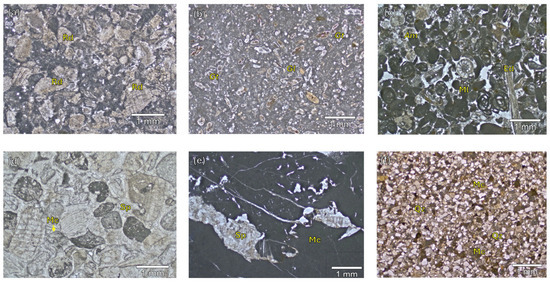
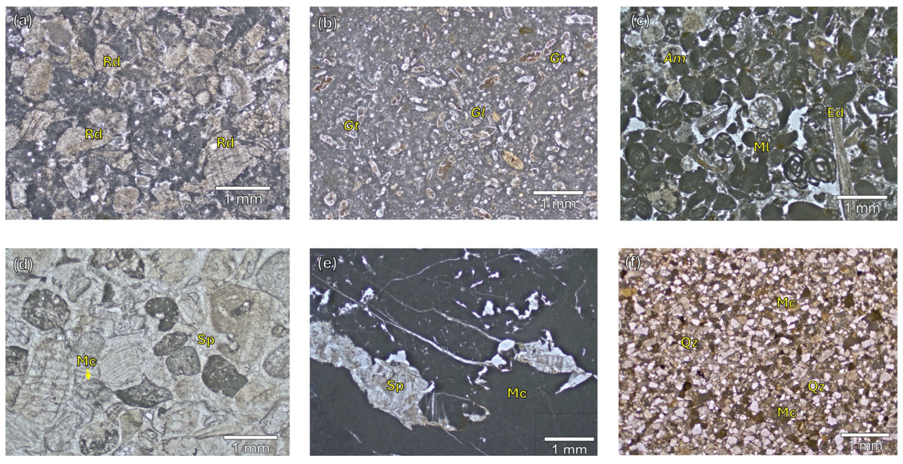
Figure 4.
PLM micrographs (plane polarized light) of a selection of samples of sedimentary rocks. (a) OD_12; (b) OD_08; (c) OD_41; (d) OD_37; (e) OD_36; (f) OD_18; Rd, Rudists; Gt, Globotruncana; Gl, Globigerina sp.; Am Amphistegina sp.; Ml, Miliolida; Ed, Echinoderms, Mc, micritic carbonates; Sp, Sparite; Qz, Quartz.
Scaglia Rossa
The samples (OD_06; OD_08; OD_10; OD_16; OD_17; OD_19) analyzed mainly fall under the definition of wackestone, with abundant planktonic foraminifera (Globotruncanidae, Globigerinidae, and Heterohelicidae), less frequent calcispheres, and a rare presence of iron hydroxides and fissure-filling clay minerals, compatible with the Scaglia Rossa formation.
In the Veneto region, the Scaglia Rossa formation outcrops are found in the area of the Euganean [10] and Lessini Hills [50], as well as in the Possagno/Valdobbiadene area [51]. This formation is generally classified as a wackestone, characterized by the abundant presence of planktonic foraminifera and micritic cement (Figure 4b). In smaller quantities, calcispheres, radiolarians, and dinoflagellates are noted, while calpionellids, echinoderms, and bivalves are rarer.
Vicenza Stone
Three of the samples analyzed are Vicenza stone (OD_41; OD_54; OD_55), a soft limestone that outcrops mainly in the Berici Hills and the Lessini Mountains [9,52]. All three samples have a petrographic profile that is consistent with the Oligocene formation of Castelgomberto and are partially comparable to Petrofacies 1 that was identified in the Roman site of Adria [40]. Specifically, these samples are red algae-encrusted grainstones, with an abundant presence of benthic foraminifera (including Miliolida), Rotaliida (Amphistegina sp., Asterigerina sp.), and, in lower concentrations, hyaline foraminifera. Some echinoderms, bivalves, and bryozoans are also noted. The samples are characterized by high porosity (Figure 4c).
Trieste Karst (?)
For five samples (OD_37; OD_38; OD_42; OD_43; OD_50), the basin of origin could not be identified with certainty. The petrographic data do not allow for precise attribution to a single quarry site. In fact, the lack of definitive elements and index fossils for lithotype recognition complicates the attempt to trace these samples to a specific outcrop. However, their petrographic characteristics show some consistency with the lithotypes quarried in the Trieste Karst.
The samples are mostly grainstones with abundant well-rounded clasts, which are sometimes recrystallized and surrounded by a micritic rim of microbial origin. Intraclasts of crystalline limestones are also present in almost every sample, as well as in well-developed sparitic cement (Figure 4d).
In two samples (OD_42; OD_43), traces of organogenic detritus can be recognized, including fragments of rudists, echinoderms, and algae (Bacinella irregularis).
Istrian Stone (?)
For three other samples (OD_15; OD_36; OD_49), the basin of provenance is also uncertain. The three samples are mudstones; they are characterized by the presence of fenestrae filled with sparitic calcite and rare peloids. Rare fossil fragments are also present, but they are not easily recognizable (Figure 4e). Only one sample (OD_15) possibly contains sponge spicules. The petrographic profile is partly consistent with that of compact limestones quarried in the Istrian peninsula [9].
Sandstone
Among the sedimentary rock samples, four are sandstones (OD_18; OD_22; OD_35; OD_46). They are medium-grained polygenic litharenites, predominantly consisting of carbonate clasts (80–90%) and a subordinate siliciclastic fraction (10–20%) made up of quartz and flint clasts, a common feature across all the samples. The clasts show a good degree of compaction and are well cemented, resulting in generally low porosity (Figure 4f).
The closest rock outcrops compatible with the archeological samples are those of the Venetian Prealps, where the Miocene formation of Molassa Sudalpina [51] is exposed.
4.1.2. Volcanic Rocks
All volcanic rock samples are petrographically consistent with the volcanic rocks of the Oligocene Euganean volcanic district in the Veneto region. The results of this study grouped the samples into four macrogroups based on specific textural and petro-mineralogical features.
Group 1 includes nine samples (OD_03; OD_04; OD_07; OD_11; OD_25; OD_27; OD_28; OD_31; OD_33) (Figure 5a). These are trachytes with porphyritic/glomeroporphyritic textures and a microlithic matrices. The main phenocrysts are anorthoclase, plagioclase, and biotite. Their petrographic profile corresponds well to the outcrops of M. Oliveto/M. Alto.
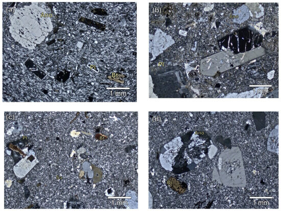
Figure 5.
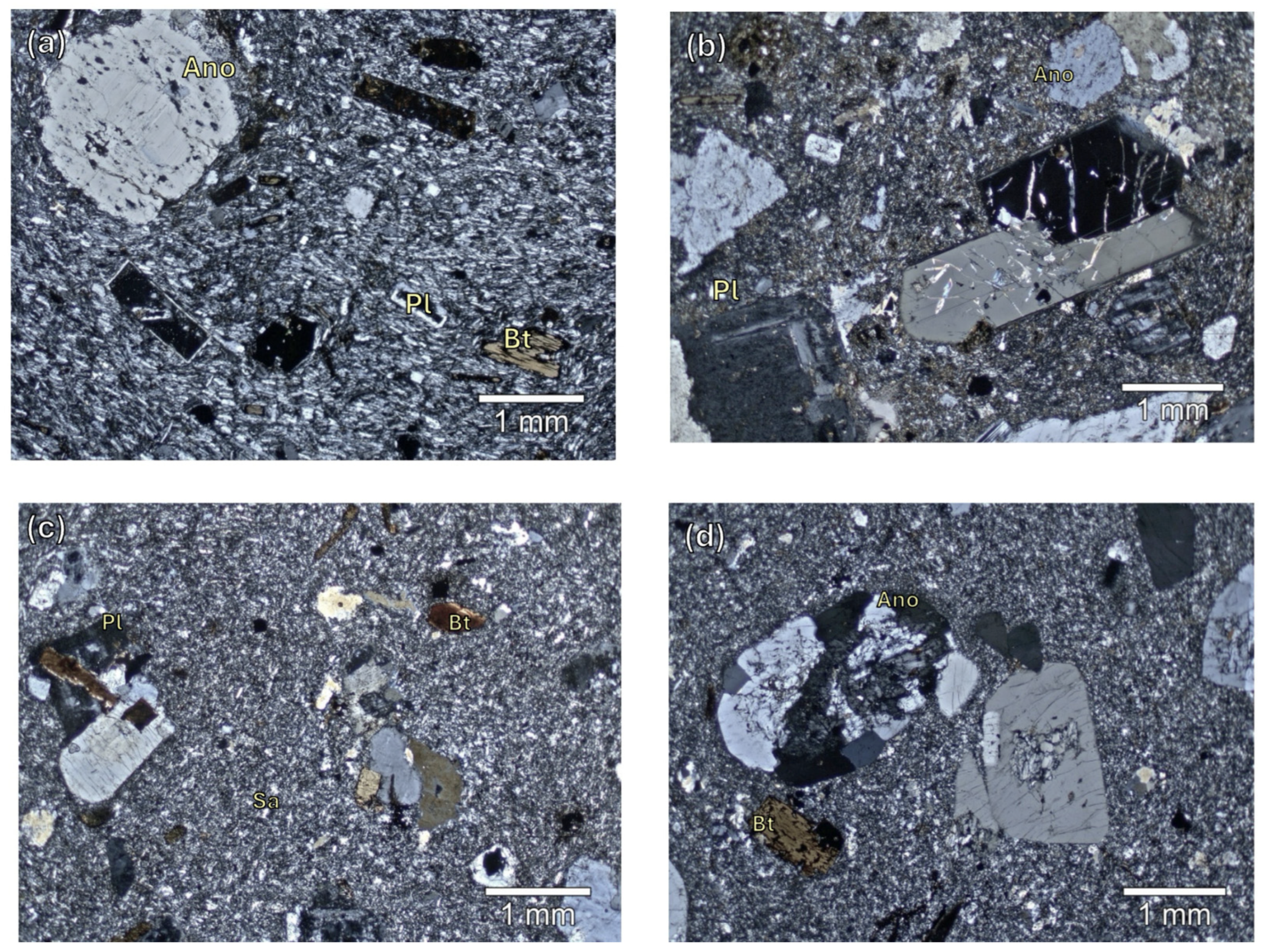
PLM micrographs (crossed polarized light) of a selection of samples of volcanic rocks. (a) OD_01; (b) OD_03; (c) OD_05; (d) OD_13; Ano, Anorthoclase; Bt, Biotite; Pl, Plagioclase; Sa, Sanidine.
Group 2 comprises four samples (OD_01; OD_02; OD_09; OD_29), whose petrographic and textural features are consistent with rocks from the Monselice quarry (Figure 5b). These trachytic rocks are characterized by phenocrysts of anorthoclase, plagioclase, and, to a lesser extent, sanidine. Accessory minerals include apatite, zircon, and opaque minerals.
Group 3 consists of a single sample (OD_05, Figure 5c), whose petrofabric does not allow for clear attribution to a specific outcrop within the Euganean district. This trachyte features a fine-grained matrix, with sanidine phenocrysts predominating over plagioclases and anorthite, as well as biotite phenocrysts among the accessory phases. The last group (Group 4) includes two samples (OD_13 and OD_14), characterized by rocks with porphyritic structures and microcrystalline matrices. These rocks contain large-grained quartz crystals embedded within the groundmass (Figure 5d).
4.2. Geochemical and Mineralogical Analyses of Volcanic Rock Samples
To achieve a more precise and detailed assessment of the provenance of the Euganean volcanic rock samples from supply basins, all analyzed samples of these lithotypes underwent chemical and mineralogical investigations via XRF and QPA-XRPD. These analyses enabled a more accurate lithotype classification and supported the attribution of samples to known quarries by assessing their geochemical and mineralogical compatibility with geological reference samples (markers) from the database of the Euganean volcanic rocks implemented by the Department of Geosciences and the Department of Cultural Heritage of the University of Padova.
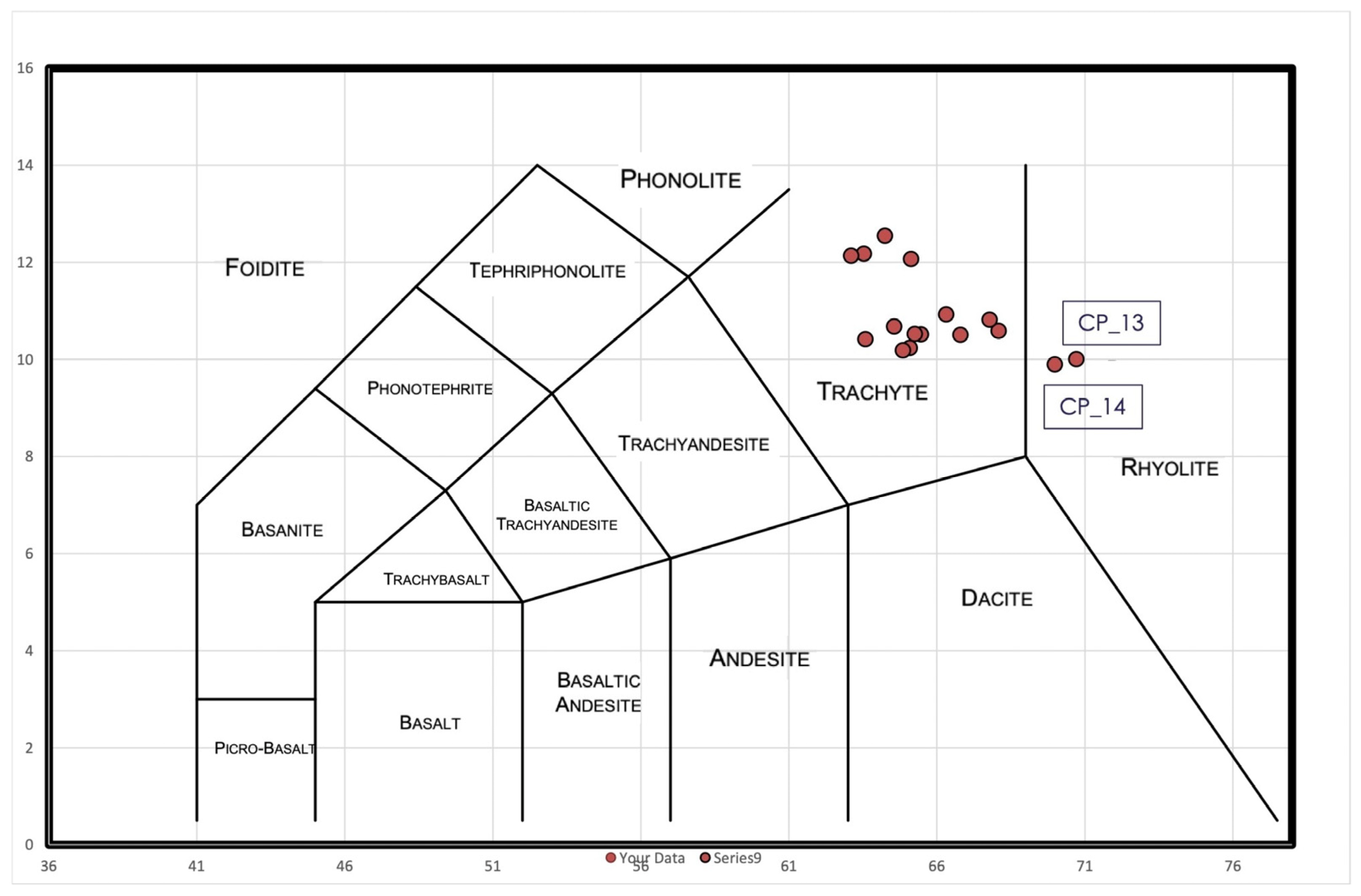
According to the TAS diagram (Figure 6), most samples display a trachytic geochemical profile, while only two samples (OD_13 and OD_14) show a rhyolitic profile, which is due to their high SiO2 content (nearly 70% wt.), as documented through the XRF analysis (Supplementary Table S1).
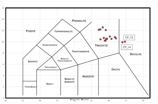
Figure 6.
Total alkali vs. silica (TAS) geo-chemical distribution diagram of the volcanic rock samples analyzed using XRF (after [53]). The samples within the rhyolite field are labeled.
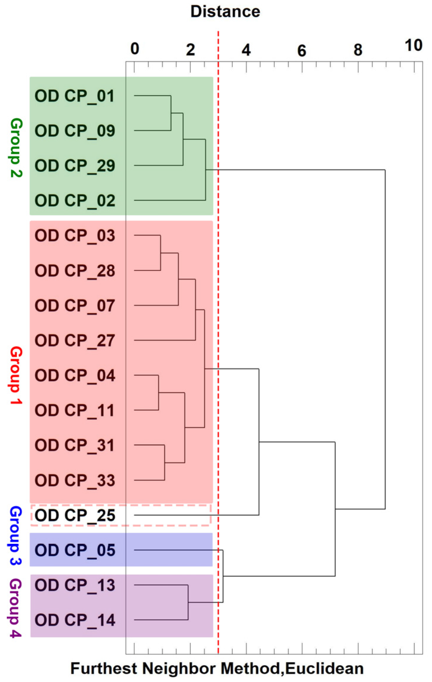
Cluster analysis, performed using the furthest neighbor method with Euclidean distance, was applied to these samples based on descriptive geochemical values determined using XRF, which allowed for the geochemical validation of the groupings determined after petrographic observations (Figure 7). Group 2 is notably composed of samples OD_01, 09, 29, and 02, while Group 1 includes samples OD_03, 28, 07, 27, 04, 11, 31, and 33, with sample OD_25 included in this cluster but at a greater distance (>4) from the other ones. This analysis also clearly identifies the two rhyolitic samples, OD_13 and OD_14 (Group 4), as well as the more isolated sample CP_05 (quartz trachyte) with a distance > 3 (Group 3).
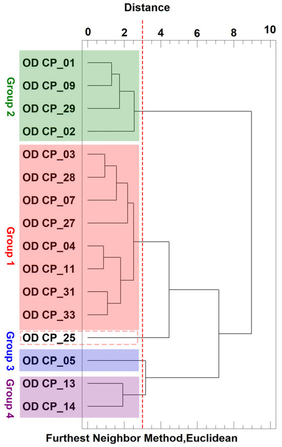
Figure 7.
Results of the cluster analysis (furthest neighbor method, Euclidean) of the Euganean volcanic rock samples from Oderzo, based on XRF data.
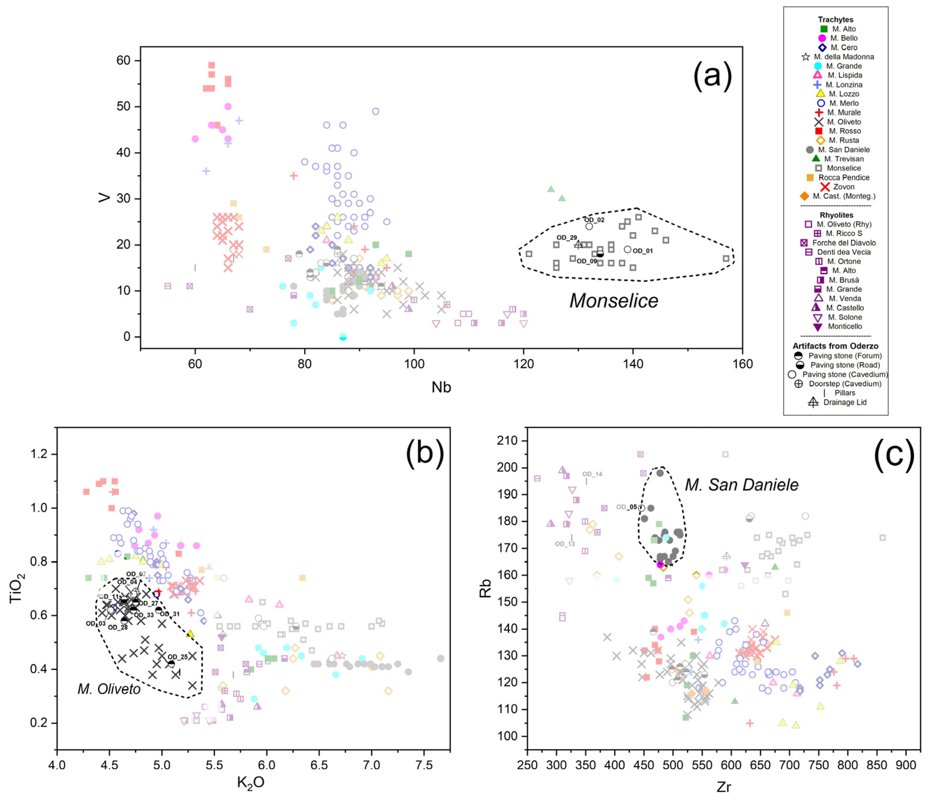
Precise provenance from quarry sites within the Euganean district was further determined by comparing the geochemical profiles of the samples from Oderzo with that of the reference ones. This was first determined by using selected bivariate scatterplots reporting selected chemical elements useful for differentiating the Euganean trachytes and rhyolites. The discriminant variables considered for the scatterplots were selected following the methodology reported by Dilaria [40] and by building on the approaches of Germinario et al. [54,55,56]. For instance, the Nb vs. V plot (Figure 8a) effectively distinguishes Group 2 samples as compatible with M. Merlo trachyte; they are clearly identifiable because of the high Nb concentrations (>120 ppm). The K2O vs. TiO2 plot (Figure 8b) is useful for isolating the trachyte from M. Oliveto, attributed to low TiO2 and K2O content. This encompasses Group 1 samples, including OD_25. Despite being somewhat separated both in the scatterplot as well as from the cluster analysis, OD_25 completely aligns with reference samples from M. Oliveto. This confirms the compatibility of this sample, along with the others of Group 1, with this outcrop rather than the nearby M. Alto, which had initially been suggested via petrographic analysis as a possible source for the rocks in this group. In the Zr vs. Rb scatterplot (Figure 8c), the clustering for M. San Daniele samples is consistent within Zr intervals around 450–500 ppm, with sample OD_05 falling within its range. Further compatibility is coherent in the K2O vs. TiO2 plot. For the rhyolitic samples OD_13 and OD_14, the Zr vs. Rb plot showing very low Zr content, below 300–350 ppm, and high Sr values, over 170 ppm. They clearly overlap with reference samples from Euganean rhyolites, though without a clear association with a specific outcrop.
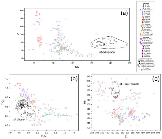
Figure 8.
(a) V vs. Nb, (b) TiO2 vs. K2O, and (c) Rb/Zr scatterplots used for the provenance discrimination of the archeological volcanic rock samples from Oderzo. Reference samples constitute the geochemical databases implemented by the Department of Cultural Heritage and the Department of Geosciences of the University of Padua, comprising modern geological samples directly collected from Euganean quarries coupled with archeological samples (analyzed in [40] and previous studies) unequivocally attributed to quarry outcrops. Indicative distributions of samples from selected quarry sites are highlighted by dotted lines. Certain archeological samples from Oderzo labeled in the scatterplots are fully described in the body of the text.
Discriminant analysis (DA) further validated the sample associations with quarry districts (Table 1, see coefficient factors in Supplementary Table S2). A series of discriminant chemical elements was used as independent variables, with samples already associated with quarry sites (samples in the reference database) as the classification factors. The selected elements for distinguishing samples are Na2O, K2O, TiO2, V, Rb, Sr, Zr, Nb, Al2O3, Nd, Ce, which are useful for trachyte discrimination, and SiO2. Ba is indicative of rhyolite differentiation. The DA achieved a 94% accuracy rate in correctly classifying 218 reference samples, highlighting the effectiveness of these variables in distinguishing the geochemical profiles of each quarry site. The results of DA, presented in Table 2, confirm the scatterplot observations and identify the best-matching quarry sites for previously unassigned archeological samples. In detail, the provenance of volcanic rock samples from Groups 1 and 2 was further confirmed through DA. Moreover, DA proved the attribution of OD_05 (Group 3) to M. San Daniele with a 100% confidence rate, while the two rhyolitic samples OD_13 and OD_14 (Group 4) were attributed to the Forche del Diavolo rhyolite outcrop in the Western part of the Euganean district with confidence levels of 99.9% and 100%, respectively. The only exception was sample OD_07, which was first associated via DA with M. Alto, though M. Oliveto is reported as its second match in probabilistic terms. Moreover, M. Alto often appeared as the second most probable source for M. Oliveto samples, underscoring the challenge of differentiating these two outcrops based solely on their geochemical footprint.

Table 1.
Results of the discriminant analysis of the archeological volcanic stone samples from Oderzo (see Supplementary Table S2 for analytical details).
Table 2.
List of the analyzed samples and their provenance according to the archaeometric analyses (Latin words appear in italics).
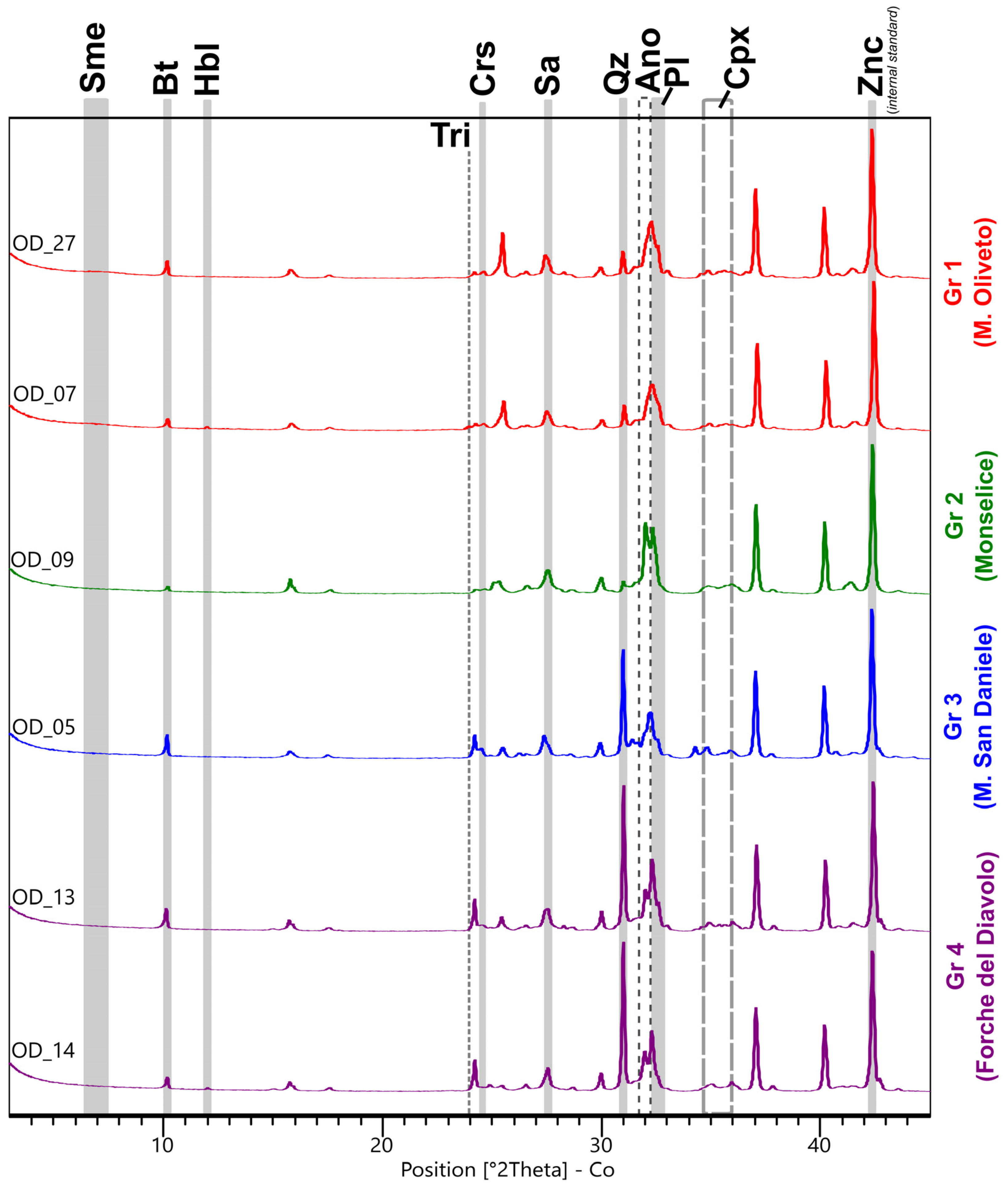
The QPA-XRPD analysis (Figure 9) of a selection of representative samples from each identified group highlights certain potential discriminant features among the Euganean volcanic rock samples based on their mineralogy. The presence of newly formed calcite as a secondary alteration in humid environments was considered, as well as that of halite produced as a consequence of salt deposition on the surface of certain samples. These phases were removed from the original mineral phases, and their quantification was recalculated at 100% wt. (Supplementary Table S3). In Figure 9, two samples from Group 1, likely attributable to M. Oliveto, exhibit a similar mineralogical profile. These rocks have a high feldspar content, predominantly plagioclase, with subordinate concentrations of sanidine and anorthoclase, while their SiO2 content is evidenced by the reduced presence of quartz and cristobalite, a high-temperature polymorph of SiO2 which can develop in volcanic rocks at temperatures typically above 1470 °C. The cryptocrystalline component of the groundmass in these samples is indicated by the significant amount of the amorphous phase (9.6–12.8 wt%), while the presence of a broad low-angle band of smectite (4.6–7.9 wt%) at around 6.5–7.5 2θ suggests considerable clay alteration processes.
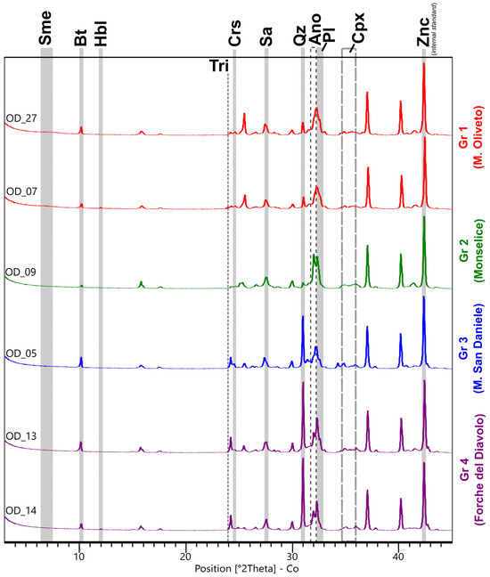
Figure 9.
XRPD profiles of selected archeological volcanic rock samples from Oderzo. For each phase, the main peaks are highlighted. The mineral phases are labeled according to [56]: Ano = anorthoclase; Bt = biotite; Cpx = clinopyroxene; Crs = cristobalite; Hbl = hornblende (kaersutite); Ilm = ilmenite; Pl = plagioclase; Qz = quartz; Sa = sanidine; Sme = smectite; Tri = tridymite. Not displayed in the graph are the main peaks of the opaque mineral Ti-magnetite (53.6 2ϑ), excluding those overlayed by the peaks of the internal standard (Zincite).
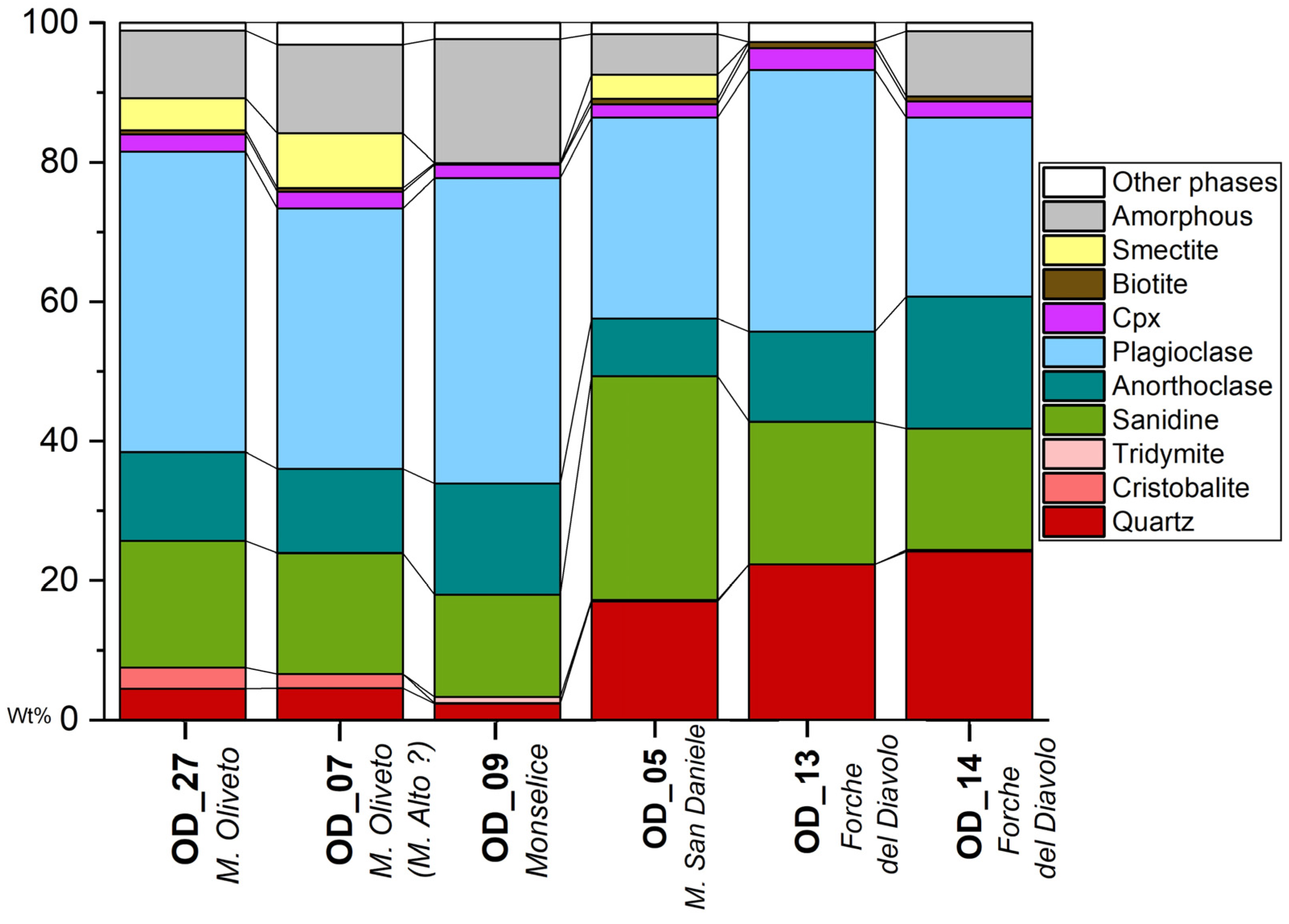
Sample OD_09, from Monselice, is distinctive due to its extremely low SiO2 mineral content, primarilly constituted by quartz and, subordinately, tridymite. Similar to cristobalite, tridymite reflects the mineralization processes in high-temperature (between 870 °C and 1470 °C) and low-pressure environments. Smectite content in this rock is practically absent, while the high amorphous content (18.1 wt%) suggests a substantial cryptocrystalline component within the groundmass of the sample. The quartz–trachyte OD_05 shows a markedly higher quartz content than the previous samples, with high-temperature SiO2 polymorphs notably absent. A distinctive feature of the M. San Daniele trachyte is its feldspar composition, where sanidine predominates over plagioclase and anorthoclase, as confirmed by petrographic studies. Mineralogically, the M. San Daniele quartz–trachyte is most similar to the two rhyolite samples OD_13 and OD_14. However, these rhyolites are characterized by higher quartz concentrations than the San Daniele sample OD_05, exceeding 20 wt%. Additionally, these two samples show a slightly lower sanidine concentration than OD_05, with a noticeable increase in Na- and Ca-rich feldspars of the anorthoclase (13.2–18.7) and plagioclase types, respectively. This mineralogy closely matches that of a geological sample from the Forche del Diavolo outcrop reported in Dilaria et al. [40] (Figure 10).
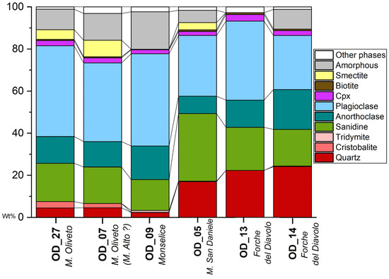
Figure 10.
Cumulative histogram bars of descriptive mineral phases of the archeological samples from Oderzo among the Euganean volcanic rocks analyzed via QPA-XRPD.
5. Discussion and Conclusions
5.1. Stone Provenance
The data obtained from the analyses carried out on the collected samples provide a fairly complete picture of stone use in Roman Oderzo. Despite the different levels of detail that we have been able to obtain for determining the provenance of volcanic and sedimentary rocks, we can state with a good degree of certainty that stones were imported from almost all the main stone basins exploited in ancient times for the construction of structures and infrastructure in the city, as well as for the production of architectural artifacts (Table 2).
Most of the samples are sedimentary rocks, primarily from the eastern part of the region, specifically Aurisina limestone (nine samples), possibly Trieste Karst limestone (five samples), and Istrian stone (three samples). However, rocks from the western part of the region are also described, particularly from the Berici Hills, where Vicenza stone is quarried (three samples). The only samples that cannot be unequivocally attributed to a specific outcrop are those of Scaglia Rossa (six samples) and sandstone (four samples), whose formation outcrops in several parts of the region, including the prealpine area, which is only 30 km away from Oderzo. The relatively short distance from the outcrop area, which could have been easily reached by traveling up the Piave Valley, might suggest the import of Scaglia Rossa from this area located to the north of the town. However, at this stage of the study, this can only be a hypothesis as there is still a lack of petrographic elements that would allow for the archeological samples to be assigned to such a basin.
On the other hand, 16 of the analyzed samples are fully compatible with the magmatic outcrops of the Euganean Hills. The application of the multi-analytical approach described above allowed us to identify the specific quarries of origin with a good degree of accuracy, namely M. Oliveto (eight samples), Monselice (four samples), M. Alto (one sample), and M. San Daniele (one sample). However, for two samples, which differ from the others because of their rhyolitic chemistry, we can only predict their potential outcrops of provenance since the our current in-house database of geological rhyolite samples is not detailed enough to be considered comprehensive of all the different possible rhyolite sources in the Euganean territory. However, from a petrographical, mineralogical, and geochemical point of view, the samples seem comparable with the geological ones collected from this outcrop and reported in Dilaria et al. [40]. Therefore, according to the current state of research, these samples were associated with the Euganean outcrop of Forche del Diavolo.
In summary, the builders of Opitergium obtained stone material from both the western (Euganean Hills and Berici Hills) and eastern (Trieste Karst and Istria) regions. There remains a fraction of elements (Scaglia Rossa, sandstone) that cannot be easily attributed to a single quarrying basin, but its petrographic profile is nevertheless compatible with prealpine rock outcrops.
5.2. Ways of Use and Chronology
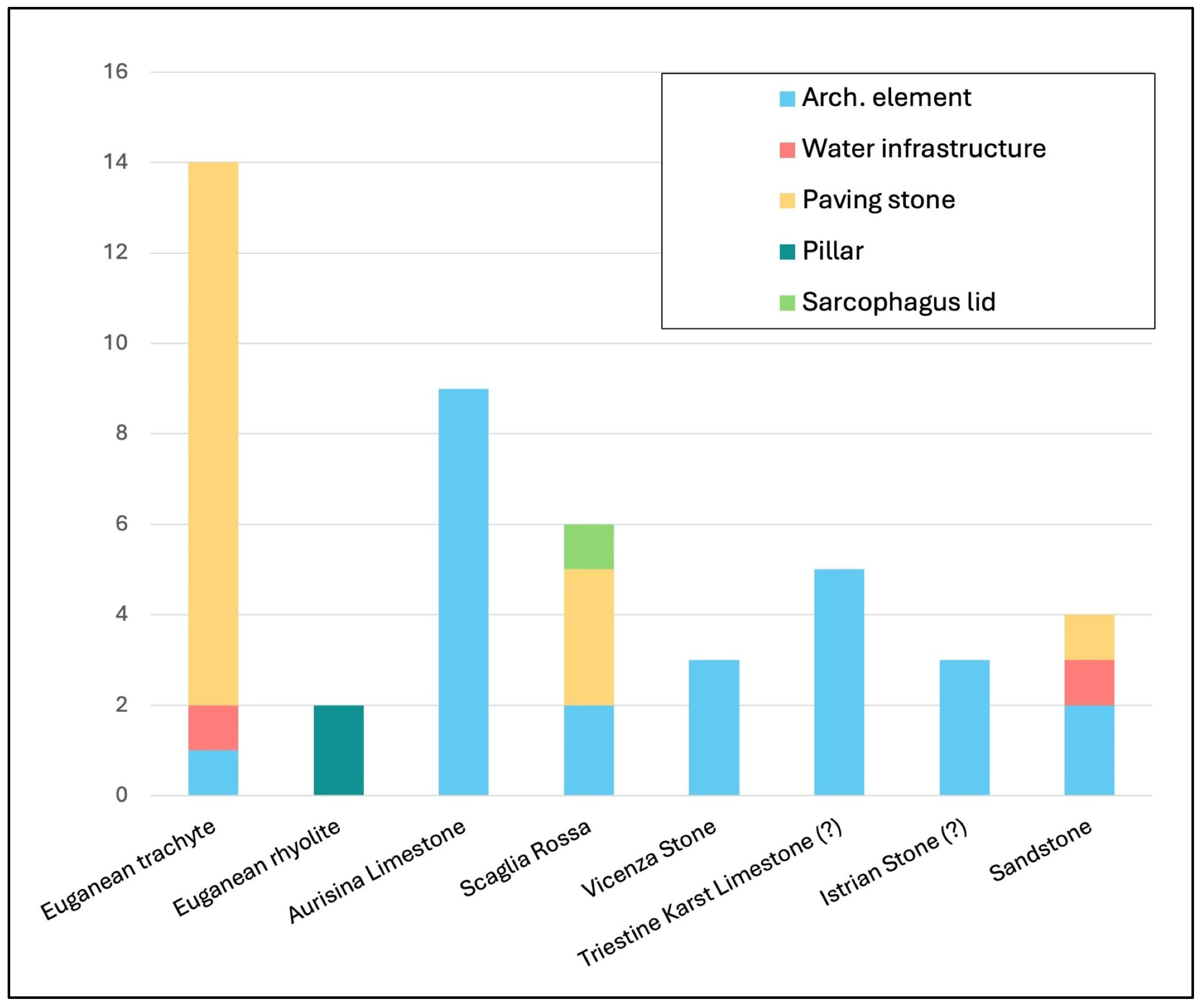
The identification of the stones used in structures and for the production of architectural elements suggests some interesting considerations about the association of particular lithotypes with specific ways of use (Figure 11).
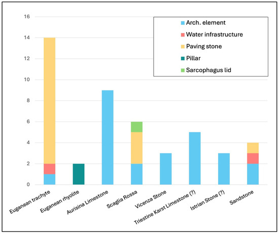
Figure 11.
Diagram showing the correlation of documented lithotypes with specific functions.
One immediately obvious fact is that Euganean trachyte was used almost exclusively for the construction of infrastructure. For instance, the cover of the southern drainage channel of the forum and the two paving stones sampled in the area of the Ex Carceri are made of Euganean trachyte. The contexts in which trachyte appears to be most widely used are in the forum, whose paving, confirming what had been already stated by Zara [3], is primarily made of trachyte from M. Oliveto, and the city gate, where trachyte blocks from Monselice, M. Oliveto, and M. San Daniele were used for paving the cavaedium. The co-presence of stones from different quarries in the same pavement, which is actually an extension of the paved road that crossed the walls at the city gate, implies the simultaneous supply of material from different quarries, a reasonable solution to meet the large demand for stones needed to pave the whole road network of the city [3].
It seems clear that the ancient builders of Opitergium preferred, or were constrained by trade agreements whose nature is still unclear, to obtain trachyte exclusively from quarries located in the eastern and southeastern parts of the Euganean Hills. It is interesting to note the absence of materials from the M. Merlo quarry, which on the contrary is the most commonly used variety in Padua and Vicenza [3]. Outcrops from the western and southwestern slopes of the Euganean Hills are also absent.
The two samples of rhyolite taken from two pillars located on the side of the paved road in the area of the Ex Carceri deserve special attention. In this case, the builders’ choice of material could have been influenced by the morphology of the outcrop itself. At Forche del Diavolo, in fact, located in the western part of the Euganean Hills, the rhyolite exhibits a natural columnar structure (Figure 12).
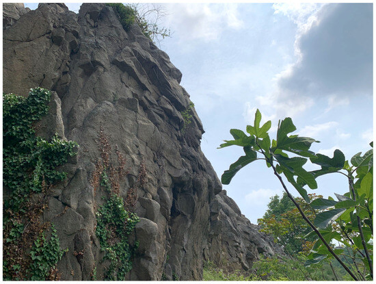
Figure 12.
Rhyolitic outcrop of Forche del Diavolo (photo by S. Dilaria).
Although used in smaller quantities than volcanic rocks, sedimentary rocks are also documented in infrastructures, primarily for restoration works. For example, between the 3rd and 4th centuries, the floor of the cavaedium of the city gate was restored using slabs and blocks of Scaglia Rossa, and a threshold of Aurisina limestone was also laid. Additionally, the restoration of the forum square, which involved replacing some slabs, was carried out using sedimentary rocks, namely sandstone.
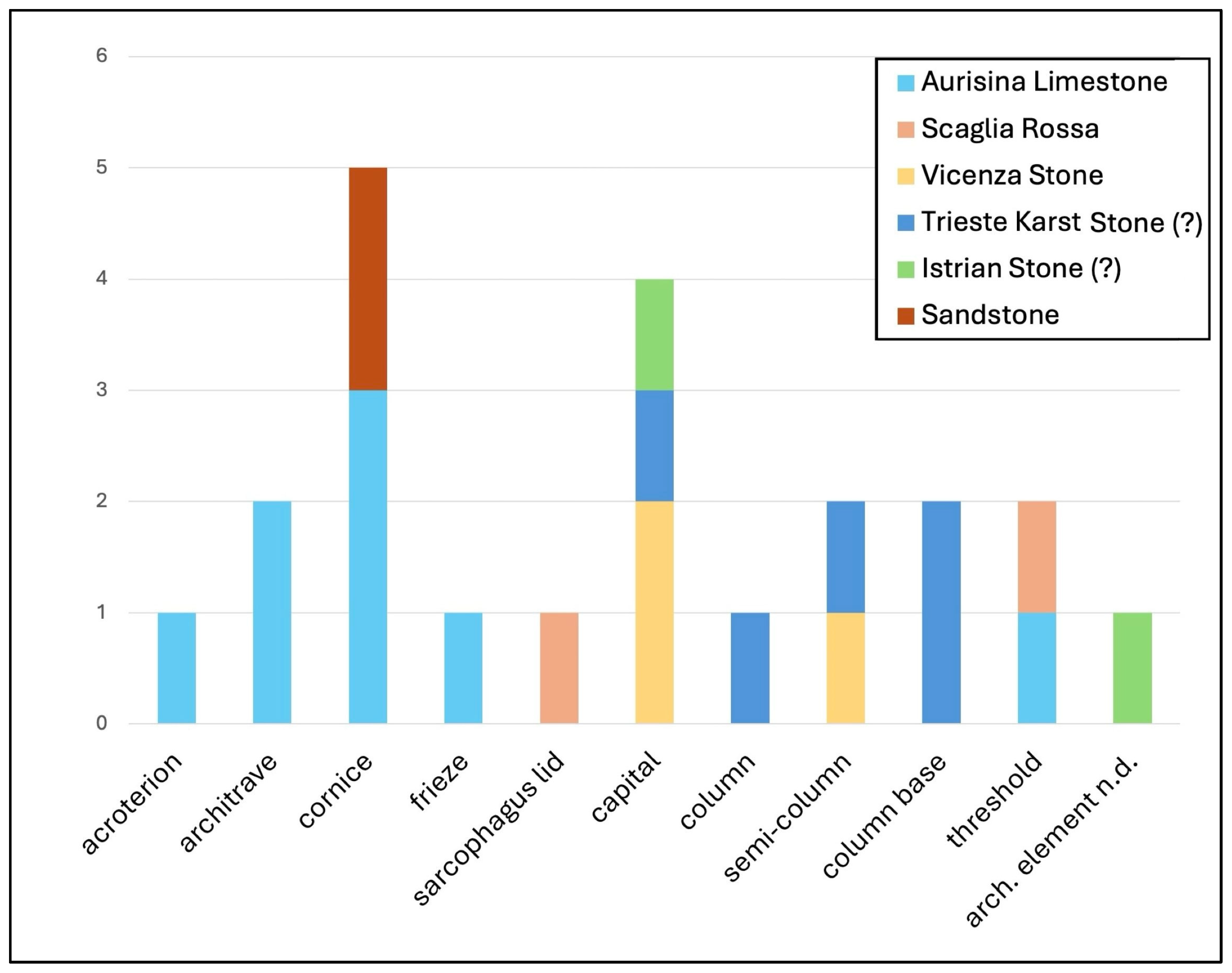
However, the main use of sedimentary rocks appears to be in the production of architectural elements (Figure 13). There is a noticeable preference for Vicenza stone in the creation of columns and capitals, likely due to its workability and esthetic qualities. In contrast, Aurisina limestone is favored for architraves and cornices.

Figure 13.
Diagram showing the correlation of documented sedimentary stones with specific architectural elements.
Regarding chronology, of the samples twenty, nineteen of which are architectural elements, while one was a sarcophagus lid that was reused in the 7th century wall; we do not have precise chronological data. The remaining 16 samples, however, belong to in situ structures in the area of the forum and the Ex Carceri, and this allows us to make some observations about the chronology of the use of certain lithotypes.
By analyzing the available data, we can conclude that between the second half of the 1st century BC and the 1st century AD, a large quantity of stone material was imported to the sites of Opitergium, particularly Euganean trachyte and, to a lesser extent, Aurisina limestone and sandstone. This finding is not surprising given that the paving of the forum, as well as the paving of the road and the cavaedium in the Ex Carceri, dates back to the transition between the 1st century BC and the 1st century AD.
According to the study of the samples, after this period Oderzo would not have imported new trachyte, or at least not in large quantities, until at least the 3rd century AD, an important phase of infrastructural restructuring in the Ex Carceri area is dated. It is also in this period that we find the most significant examples of Scaglia Rossa, along with the only two instances of rhyolite used in the construction of two pillars placed along the paved road.
However, no particular trends seem to emerge in the importation of Aurisina limestone, which is found in structures and used for the production of artifacts starting from the 1st century AD and continuing at least until the 4th century AD.
5.3. Trade Networks
The identification of the quarries of origin for the stones used in Oderzo allows us to expand our considerations to the broader topic of the dynamics of stone material circulation in Roman times.
Like today, the region was crossed by a dense network of waterways, which served as a communication system between urban centers, the coast, and, of course, the aforementioned quarries. It was mainly along these waterways that heavy loads of stone extracted from the quarries were transported to urban construction sites, taking advantage of the numerous roads that crossed the region only when strictly necessary. To reconstruct which of these routes were used to bring stone resources to Oderzo, it is necessary to recall the main features of the X Regio’s hydrographic and road network (Figure 14).
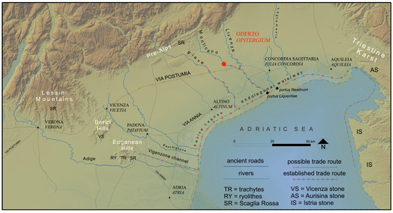
Figure 14.
Map of the X Regio depicting the extraction basins and trade networks used by ancient Oderzo for stone supply (modified from [40]; basemap elaboration by P. Kirschner, J. Bonetto).
Major rivers, the most important of which are the Po, the Adige, the Brenta, the Piave, the Livenza, and the Tagliamento, flow through what is now the Veneto region. Numerous tributaries and smaller rivers traversed the lower plain, surrounding the main urban settlements. These rivers, along with the larger ones, flowed into a complex endolagunar waterway route, which was formed by artificial canals and lagoons, which connected Ravenna to Aquileia [57]. The development of this system dates back to the transition between the 1st century BC and the 1st century AD, running roughly parallel to the Via Annia, which had been constructed more than a century earlier [26,58]. A little further north was the already mentioned Via Postumia, which crossed the entire Transpadana region, connecting Genoa with Aquileia and passing just south of Oderzo.
The close connection between river and land routes created a capillary communication and trade system in which urban centers such as Oderzo served as commercial crossroads. It is not surprising then that building materials, especially stone ones, could be brought to the city’s construction sites even from geographically distant areas.
The most frequently identified building material among the analyzed samples is, as mentioned above, limestone which came from both the Berici Hills and the Trieste Karst and possibly the Istrian peninsula. Given the short distance of the quarries from the coast [1] and the economic advantages of transport by sea [59], it is likely that the material from the Karst and Histria regions reached Oderzo by sea, possibly using the aforementioned articulated endolagunar system to reach the portus Liquentiae [60]. From there, it was possible to go up the Livenza river and then the Monticano river until finally reaching Opitergium.
Different possible solutions can be proposed for the transportation of the soft limestone from the Berici Hills. It is possible, if not very likely, that the Bacchiglione river was used to transport the quarried stone, a widespread practice as shown by the discovery of a wreck and its load of architectural elements [20]. In fact, the river flowed by the northeastern sector of the hills and then toward the Venetian lagoon, where it could join the endolagunar waterway. From there, the load could continue eastward until it reached the mouth of the Piave river, which is near today’s small coastal town of Jesolo [60]. The stone load could then travel up the river until it reached the area nearby Oderzo, where it would finally be transported by land for the last leg of the journey. However, the Piave route is not the only possible option; it is also likely that the stone continued its journey to the portus Liquentiae following the route hypothesized for the limestones coming from the Karst region. Such a route would have allowed for closer access to the urban center by taking advantage of waterways and minimizing overland travel. However, a third hypothesis should be considered, although it is less likely given the economic disadvantages associated with it [59]. To the northwest of the Berici Hills ran the aforementioned Via Postumia, which passed through Vicenza and continued eastward until it reached Oderzo’s territory, passing just south of the city. Therefore, the limestone quarried in the Berici Hills could have been transported to Vicenza and from there to Oderzo by charts. This remains a viable hypothesis, especially considering the relatively low demand for such materials; this seems likely given the analysis of the archeological samples examined in this study.
On the other hand, it seems reasonable to exclude the hypothesis of a land transport route for the loads of trachyte coming from the quarries of M. Oliveto, M. Alto, and Monselice given the large quantity of material that was surely needed to pave the forum and the city roads. Indeed, the route suggested by J. Bonetto [40], who identifies the Vigenzone canal as the ancient Togisonus mentioned by Pliny the Elder (Naturalis Historia, 3.121), appears convincing. The canal serves as a link between the eastern slope of the Euganean district, where M. Oliveto and M. Alto are located, and the endolagunar waterway already mentioned several times. From there, the stone load could have been transported eastward along the Adriatic arc to the Liquentiae port and finally to Oderzo by following the same routes proposed for the limestones. The Monselice trachyte, on the other hand, could have reached the endolagunar way via a palaeo-branch of the Adige river, which flowed near the southern sector of the Euganean Hills.
The Scaglia Rossa likely followed a similar route, granted it was quarried from the Euganean Hills or the Lessini Mountains near which the Adige river flowed. If it came from the Prealps, however, it probably followed the course of the Piave river, which flows through present-day Valdobbiadene and Possagno, passing by the Montello and descending to the plain close to the town. The sandstone, too, could have been transported along this route if it was quarried from the Miocene outcrops that define the foothills between Bassano del Grappa and Vittorio Veneto [51].
This network of waterways and routes clearly played a strategic role in the trade system of the region and served as a vital source of raw materials, including stone, for urban development. The variety of lithotypes found in construction, even from quarries located some distance away, further highlights the significance of the ancient settlement and defines Opitergium as a grand, monumental city.
Having analyzed the uses and trade routes of the different lithotypes documented in Oderzo, we can now broaden our discussion to the reasons that compelled the builders to choose a specific stone outcrop. The city, as already mentioned, is situated in the heart of the Treviso–Venetian plain, at a point that is equidistant from both the western and eastern outcrops, about 80–90 km from the Euganean Hills and the neighboring Berici Hills, while the distance to the Trieste Karst is about 90–100 km. Therefore, there are no quarrying basins, except perhaps those along the Prealps, which are only 30 km away from Oderzo, that are particularly close to the city for which one could assume a clear preference.
It was other reasons then, rather than proximity to the quarries, that dictated the selection of the different lithotypes documented. It is reasonable to assume that the first factor guiding the builders’ choices must have been the physical and mechanical properties in the rock that made it particularly suited to the function it was destined to. Trachyte, for example, is a rock that is relatively easy to quarry and work with, and it is nevertheless characterized by good hardness, resistance to impact and compression, and poor polishability by friction [3], characteristics that make it a particularly suitable material for use as a floor covering, as found, for example, in the Forum of Oderzo.
The Aurisina limestone is also one of the most suitable carbonate formations for building. In fact, it is a compact limestone that is resistant to use and compression [49], qualities that were certainly already well known in Roman times. Therefore, it is not surprising that in Oderzo, most of the architectural elements were made of Aurisina limestone. It is also an esthetically pleasing material that, when polished, can resemble marble, which may have led the ancient builders to choose it as a viable and cheaper alternative. On the other hand, Vicenza stone seems to be less durable. However, its lower hardness and compactness make it easy to work, which was undoubtedly an advantage for architectural decoration.
The main physical–mechanical properties of each lithotype were certainly well known to both the builders and the quarry workers, between whom there must have been a close professional and collaborative relationship [59]. It is therefore likely that the choice of stone material to be used was not suggested by the client but by the very workmen charged with completing the building project. Similarly, it cannot be ruled out that there were close, albeit undefined, links between the client and/or architect of a particular building and the source of the material used on that site.
6. Conclusions
The variety of lithotypes found in construction, even from quarries located some distance away, further highlights the significance of the ancient settlement and defines Opitergium as a grand, monumental city.
The builders of Opitergium sourced stone materials from both the western regions (Euganean Hills and Berici Hills) and the eastern regions (Trieste Karst and Istria). A portion of the materials, including Scaglia Rossa and sandstone, cannot be definitively linked to a specific quarrying area, though their petrographic characteristics are consistent with prealpine rock formations.
The identification of the stones used in structures and for the production of architectural elements suggests a clear prevalence of Euganean trachyte for infrastructure and sedimentary rocks for the production of architectural elements. We can also affirm that the considerable use of stone in the building sites of Oderzo dates back to the transition between the 1st century BC and the 1st century AD, a time frame that aligns perfectly with the onset of the major urban and monumental projects that defined Oderzo and the entire X Regio.
The transport of material from the quarries to the urban centers probably took place mostly along the river routes that, both then and now, characterized the Venetian plain. This network of waterways and routes clearly played a strategic role in the trade system of the region and served as a vital source of raw materials, including stone, for urban development.
Supplementary Materials
The following supporting information can be downloaded at the following website: https://www.mdpi.com/article/10.3390/heritage8020044/s1, Supplementary Table S1: Results of the XRF analyses reported as wt% in oxides for major elements and as ppm for trace elements. B.d. = below detection limit. Supplementary Table S2: Classification function coefficients for trachytes and ryolites of the Euganean volcanic districts (markers) considered in this study. Supplementary Table S3: Results of the QPA-XRPD analysis of selected quarry-correlated archeological samples of volcanic rocks. b.d. = below detection limit.
Author Contributions
Conceptualization: C.G., C.P. and S.D.; methodology: C.P., S.D. and C.M.; formal analysis: C.G., S.D. and C.M.; investigation: C.G., S.D., and C.M.; writing: C.G. (Section 1; Section 2; Section 3.1; Section 3.2; Section 5), C.P. (Section 2; Section 3.1; Section 5), S.D. (Section 3.2; Section 4.2), C.M. (Section 4.1) and J.B. (Section 5). All authors have read and agreed to the published version of the manuscript.
Funding
This research was supported in the framework of the PON REACT-EU 2014/2020 projects DM 1061/2021—Action IV.6, BUILDing sustainABILITY in the Ancient World. Urban development, land use and conservation of the ecosystem and DM 1061/2021—Action IV.5—Cities, architecture and environmental sustainability: selection, exploitation and management of natural resources for the construction of urban centers in Roman Cisalpine. The preparation of the samples for OM, XRF and XRPD analyses was developed at the Department of Geosciences of the University of Padova. The research was implemented and funded within the scopes of the University of Padova under the World Class Research Infrastructures (WCRI) program—SYCURI (Synergic Strategies for Culture Heritage at Risk). The paper was also financed from the project “Trade and use of volcanic pozzolans in the Roman world. A natural material for the production of eco-sustainable concrete of antiquity” (Principal investigator: Simone Dilaria, BIRD 2023 of the Department of Cultural Heritage of the University of Padova, project code BIRD230232/23. Stone samples were collected with the authorization of the Soprintendenza Archeologia, Belle Arti e Paesaggio per l’area metropolitana di Venezia e le province di Belluno, Padova e Treviso (Prot. n. 23289 del 15 July 2022).
Data Availability Statement
The data other than those reported in the text and in the supplementary materials are available on request from the corresponding authors.
Conflicts of Interest
The authors declare no conflicts of interest.
References
- Previato, C. Aquileia. In Materiali, Forme e Sistemi Costruttivi Dall’età Repubblicana Alla Tarda età Imperiale; Padova University Press: Padova, Italy, 2015. [Google Scholar]
- Previato, C. Aurisina limestone in the Roman Age: From Karst Quarries to the cities of the Adriatic basin. In AMOSIA XI. Interdisciplinary Studies of Ancient Stone. Proceedings of the Eleventh International Conference of ASMOSIA, Split 18–22 May 2015; Poljak, M., Marasović, K., Eds.; University of Split: Split, Croatia, 2018; pp. 933–939. [Google Scholar]
- Zara, A. La Trachite Euganea: Archeologia e Storia di una Risorsa Lapidea del Veneto Antico; Edizioni Quasar: Rome, Italy, 2018. [Google Scholar]
- Previato, C.; Zara, A. A database and GIS project about the quarrying, circulation and use of stone during the roman age in Regio X—Venetia et Histria. The case study of euganean trachyte. In AMOSIA XI. Interdisciplinary Studies of Ancient Stone. Proceedings of the Eleventh International Conference of ASMOSIA, Split 18–22 May 2015; Poljak, M., Marasović, K., Eds.; University of Split: Split, Croatia, 2018; pp. 597–609. [Google Scholar]
- Germinario, L.; Zara, A.; Maritan, L.; Bonetto, J.; Hanchar, J.M.; Sassi, R.; Siegesmund, S.; Mazzoli, C. Tracking trachyte on the Roman routes: Provenance study of Roman infrastructure and insights into ancient trades in northern Italy. Geoarchaeology 2018, 33, 417–429. [Google Scholar] [CrossRef]
- Dilaria, S.; Ricci, G.; Secco, M.; Beltrame, C.; Costa, E.; Bonetto, J.; Artioli, G. Vitruvian binders in Venice: First evidence of Phlegraean pozzolans in an underwater Roman construction in the Venice Lagoon. PLoS ONE 2024, 19, e0313917. [Google Scholar] [CrossRef] [PubMed]
- Cornale, P.; Rosanò, P. Le Pietre Tenere del Vicentino. Uso e Restauro; La Grafica & Stampa: Vicenza, Italy, 1994. [Google Scholar]
- Lazzarini, L. Pietra d’Istria: Genesi, proprietà e cavatura della pietra di Venezia. In La Pietra d’Istria e Venezia. Atti del Seminario di Studio; Fiorentin, N., Ed.; Cierre Edizioni: Verona, Italy, 2006; pp. 24–45. [Google Scholar]
- Astolfi, G.; Colombara, F. La Geologia dei Colli Euganei; Programma: Padova, Italy, 1990. [Google Scholar]
- Guerra, R. Liquentia: Un Fiume Nella X Regio Augustea Venetia et Histria; Tipolitografia Rubino: S. Stino di Livenza, Italy, 2005. [Google Scholar]
- Buonopane, A. Estrazione, lavorazione e commercio dei materiali lapidei. In Il Veneto nell’Età Romana; Buchi, E., Ed.; Banca Popolare di Verona: Verona, Italy, 1987; Volume 1, pp. 187–224. [Google Scholar]
- Bridi, E. L’edilizia Pubblica di Verona Romana: Materiali, Cantieri, Sistemi Costruttivi, Economie e Committenze. Ph.D. Thesis, Università Degli Studi di Padova, Padova, Italy, 2023. [Google Scholar]
- Capedri, S.; Grandi, R.; Venturelli, G. Trachytes used for paving Roman roads in the Po Plain: Characterization by petrographic and chemical parameters and provenance of flagstones. J. Archaeol. Sci. 2003, 30, 491–509. [Google Scholar] [CrossRef]
- Flügel, E.; Flügel, C. Applied microfacies analysis: Provenance studies of Roman mosaic stones. Facies 1997, 37, 1–48. [Google Scholar] [CrossRef]
- Roffia, E.; Bugini, R.; Folli, L. Stone materials of the Roman villas around Lake Garda (Italy). In ASMOSIA VII; Maniatis, Y., Ed.; BCH Supplement 51; Ecole Francaise d’Athenes: Athens, Greece, 2009; pp. 559–570. [Google Scholar]
- De Vecchi, G. Analisi delle pietre e dei materiali edilizi. In L’Area del Capitolium di Verona. Ricerche Storiche e Archeologiche; Cavalieri Manasse, G., Ed.; Cortella Poligrafica: Verona, Italy, 2008. [Google Scholar]
- Falezza, G.; Zorzin, R.; Lazzarini, L.; Bonetto, J. Il contesto geologico e il materiale da costruzione impiegato nel santuario. In Archeologia e Storia sul Monte Castelon di Marano di Valpolicella; Bruno, B., Falezza, G., Eds.; Sap Società Archeologica S.R.L.: San Lorenzo, Italy, 2016; pp. 233–244. [Google Scholar]
- Lazzarini, L. The minero-petrographic analysis of two flagstones (“basoli”) recovered from Treporti (Venice Lagoon) and Altinum. In Crossing the Water. The Venice Lagoon from Antiquity Throughout the Centuries; Bassani, M., D’Acunto, G., Madricardo, F., Eds.; L’Erma Di Bretschneider: Roma, Italy, 2022; pp. 155–161. [Google Scholar]
- Brajkovič, R.; Djurić, B.; Gerčar, D.; Cvetko Tešović, B.; Rožič, B.; Gale, L. Mid-Cretaceous calcarenite in stone products from the Roman colony of Emona, Regio X (modern Ljubljana, Slovenia). Archaeometry 2023, 65, 17–35. [Google Scholar] [CrossRef]
- Previato, C.; Zara, A. Il trasporto della pietra di Vicenza in età romana. Il relitto del fiume Bacchiglione. Marmora 2014, 10, 59–78. [Google Scholar]
- Bonetto, J.; Dilaria, S.; Girotto, C.; Previato, C.; Falezza, G.; Facchi, A. Tra le cave e il Delta del Po: Vie di trasporto e dinamiche del commercio della pietra. In Forme e Aspetti del Paesaggio. Percorrendo le Strade dell’Italia Antica; Atlante Tematico di Topografia Antica; L’Erma di Bretschneider: Roma, Italy, 2025. [Google Scholar]
- Tirelli, M. Oderzo. In Il Veneto nell’Età Romana. II. Note di Urbanistica e di Archeologia del Territorio; Cavalieri Manasse, G., Ed.; Banca Popolare di Verona: Verona, Italy, 1987; pp. 358–390. [Google Scholar]
- Busana, M.S. Oderzo. Forma Urbis. Saggio di Topografia Antica; “L’Erma” di Bretschneider: Roma, Italy, 1995. [Google Scholar]
- Tirelli, M. Itinerari Archeologici di Oderzo; Canova: Treviso, Italy, 2003. [Google Scholar]
- Tirelli, M. Opitergium, municipio romano. In L’anima delle Cose. Riti e Corredi della Necropoli Romana di Opitergium. Catalogo della Mostra; Mascardi, M., Tirelli, M., Eds.; Ca’ Foscari-Digital Publishing: Venezia, Italy, 2019; pp. 27–36. [Google Scholar]
- Bosio, L. Le Strade Romane della Venetia e dell’Histria; Esedra: Padova, Italy, 1997. [Google Scholar]
- Tirelli, M. L’area del foro di Oderzo (Treviso). In La Città nella Città. Sistemazione di RESTI Archeologici in Area Urbana: L’Italia del Nord; Croce Da Villa, P., Dal Pos, M., Penzo, A., Eds.; Tipografia Sagittaria: Concordia Sagittaria, Italy, 1989; pp. 39–47. [Google Scholar]
- Tirelli, M.; Sandrini, G.M. Oderzo. Balneum nei quartieri settentrionali. Quad. Archeol. Veneto 1990, 6, 155–161. [Google Scholar]
- Ruta Serafini, A.; Tirelli, M. Dalle origini all’alto medioevo: Uno spaccato urbano di Oderzo dallo scavo dell’ex stadio. Quad. Archeol. Veneto 2004, 20, 135–152. [Google Scholar]
- Tirelli, M.; Malizia, A. Note preliminari sul rinvenimento di domus romane nel settore urbano nord-orientale dell’antica Oderzo. Quad. Archeol. Veneto 1985, 1, 151–165. [Google Scholar]
- Tirelli, M. La domus di via Mazzini ad Oderzo (Treviso). Quad. Archeol. Veneto 1987, 3, 171–192. [Google Scholar]
- Tirelli, M. Oderzo: Resti di basolato stradale tra Piazza Vittorio Emanuele e Piazza Castello. Quad. Archeol. Veneto 1989, 5, 75–76. [Google Scholar]
- Cipriano, S.; Sandrini, G.M. La banchina fluviale di Opitergium. Antich. Altoadriatiche 2001, 46, 289–294. [Google Scholar]
- Bonetto, J. Mura e Città nella Transpadana Romana; Fondazione “Antonio Colluto”: Portogruaro, Italy, 1998. [Google Scholar]
- Braconi, M. Il banchetto e la caccia su due mosaici pavimentali di Oderzo fra tradizione iconografica e autorappresentazione. Antich. Altoadriatiche 2016, 86, 281–303. [Google Scholar]
- Castagna, D.; Tirelli, M. Evidenze archeologiche di Oderzo tardo-antica ed altomedievale: I risultati preliminari di indagini recenti. In Città, Castelli, Campagne nei Territori di Frontiera (Secoli VI–VII); Brogiolo, G.P., Ed.; Documenti di Archeologia; Sap Società Archeologica S.R.L.: San Lorenzo, Italy, 1995; pp. 121–134. [Google Scholar]
- Tirelli, M. Spolia dalla necropoli opitergina: Monumenta. In La Necropoli di Opitergium, Atti della Giornata di Studi Intorno alla Mostra L’anima delle Cose, Oderzo, 25 Maggio 2021; Mascardi, M., Tirelli, M., Vallicelli, M.C., Eds.; Edizioni Ca’ Foscari: Venezia, Italy, 2023; pp. 11–30. [Google Scholar]
- Girotto, C.; Marchet, B. Pietre e marmi antichi: Forme del riuso nell’area delle Ex Carceri di Oderzo (TV). In Atti del Convegno Forme in Movimento. Modelli, Metodi e Contesti tra Continuità e Innovazione; Padova University Press: Padua, Italy, 2025; in press. [Google Scholar]
- Forlati Tamaro, B. Iscrizioni Lapidarie Latine del Museo Civico di Oderzo; Marton Editore: Treviso, Italy, 1976. [Google Scholar]
- Dilaria, S.; Bonetto, J.; Germinario, L.; Previato, C.; Girotto, C.; Mazzoli, C. The stone artifacts of the National Archaeological Museum of Adria (Rovigo, Italy): A noteworthy example of heterogeneity. Archaeol. Anthropol. Sci. 2024, 16, 14. [Google Scholar] [CrossRef]
- Calvino, F. Le Cave dei Colli Euganei. Caratteristiche Geominerarie. Importanza Economica. Prospettive di Sviluppo; Consorzio per la Valorizzazione dei Colli Euganei: Padova, Italy, 1967. [Google Scholar]
- Germinario, L.; Hanchar, J.M.; Sassi, R.; Maritan, L.; Cossio, R.; Borghi, A.; Mazzoli, C. New petrographic and geochemical tracers for recognizing the provenance quarry of trachyte of the Euganean Hills, northeastern Italy. Geoarchaeology 2018, 33, 430–452. [Google Scholar] [CrossRef]
- Rietveld, H.M. Line profiles of neutron powder-diffraction peaks for structure refinement. Acta Crystallogr. 1967, 22, 151–152. [Google Scholar] [CrossRef]
- Dollase, W. Correction of intensities for preferred orientation in powder diffractometry: Application of the March Model. J. Appl. Crystallogr. 1986, 19, 267–272. [Google Scholar] [CrossRef]
- Taut, T.; Kleeberg, R.; Bergmann, J. The new Seifert Rietveld program BGMN and its application to quantitative phase analysis. Mater. Struct. 1998, 5, 55–64. [Google Scholar]
- Cucchi, F.; Piano, C. Brevi Note Illustrative della Carta Geologica del Carso Classico Italiano; Università degli Studi di Trieste: Trieste, Italy, 2013. [Google Scholar]
- Cucchi, F.; Biolchi, S.; Zini, L.; Jurkovsek, B.; Kolar Jurkovsek, T. Geologia e geomorfologia del Carso Classico. In Le Acque del Carso Classico. Progetto Hydrokarst/Vodonosnik Klasičnega Krasa; Projekt Hydrokarst; EUT Edizioni: Trieste, Italy, 2015; pp. 23–52. [Google Scholar]
- Carulli, G.B.; Onofri, R. I Marmi del Carso; Del Bianco: Udine, Italy, 1969. [Google Scholar]
- Cucchi, F.; Gerdol, S. I Marmi del Carso Triestino; Camera di Commercio e Industria: Trieste, Italy, 1985. [Google Scholar]
- Massari, F.; Medizza, F. Stratigrafia e paleogeografia del Campaniano e Maastrichtiano nelle Alpi Meridionali (con particolare riguardo agli hard grounds della Scaglia rossa veneta). Mem. Ist. Geol. Mineral. Dell’Università Padova 1963, 28, 1–64. [Google Scholar]
- Antonelli, R.; Barbieri, G.; Dal Piaz, G.V.; Dal Pra, A.; De Zanche, V.; Grandesso, P.; Mietto, P.; Sedea, R.; Zanferrari, A. Carta Geologica del Veneto 1:250,000: Una Storia di Cinquecento Milioni di Anni; Regione del Veneto: Venezia, Italy, 1990. [Google Scholar]
- Cattaneo, A.; De Vecchi, G.P.; Menegazzo Vitturi, L. Le Pietre Tenere dei Colli Berici; Società Cooperativa Tipografica: Padova, Italy, 1976. [Google Scholar]
- Le Bas, M.J.R.; Maitre, R.L.; Streckeisen, A.; Zanettin, B. IUGS Subcommission on the systematics of igneous rocks, a chemical classification of volcanic rocks based on the total alkali-silica diagram. J. Petrol. 1986, 27, 745–750. [Google Scholar] [CrossRef]
- Germinario, L.; Cossio, R.; Maritan, L.; Borghi, A.; Mazzoli, C. Textural and mineralogical analysis of volcanic rocks by μ-XRF mapping. Microsc. Microanal. 2016, 22, 690–697. [Google Scholar] [CrossRef] [PubMed]
- Maritan, L.; Mazzoli, C.; Sassi, R.; Speranza, F.; Zanco, A.; Zanovello, P. Trachyte from the Roman aqueducts of Padua and Este (north-east Italy): A provenance study based on petrography, chemistry and magnetic susceptibility. Eur. J. Min. 2013, 25, 415–427. [Google Scholar] [CrossRef]
- Whitney, D.L.; Evans, B.W. Abbreviations for names of rock-forming minerals. Am. Mineral. 2010, 95, 185–187. [Google Scholar] [CrossRef]
- Rosada, G. La direttrice endolagunare e per acque interne nella decima regio maritima: Tra risorsa naturale e organizzazione antropica. In La Venetia nell’Area Padano-Danubiana. Le vie di Comunicazione, Atti del Convegno Internazionale, Venezia, 6–10 Aprile 1988; CEDAM: Padova, Italy, 1990; pp. 153–182. [Google Scholar]
- Uggeri, G. La nuova Via Annia da Roma ad Aquileia (153 a.C.). J. Anc. Topogr. 2012, 22, 157–158. [Google Scholar]
- Russell, B. The Economics of the Roman Stone Trade; Oxford Studies on the Roman Economy; Oxford Academic: Oxford, UK, 2013. [Google Scholar]
- Croce Da Villa, P. Concordia e Caorle. Antich. Altoadriatiche 1990, 36, 329–332. [Google Scholar]


Disclaimer/Publisher’s Note: The statements, opinions and data contained in all publications are solely those of the individual author(s) and contributor(s) and not of MDPI and/or the editor(s). MDPI and/or the editor(s) disclaim responsibility for any injury to people or property resulting from any ideas, methods, instructions or products referred to in the content. |
© 2025 by the authors. Licensee MDPI, Basel, Switzerland. This article is an open access article distributed under the terms and conditions of the Creative Commons Attribution (CC BY) license (https://creativecommons.org/licenses/by/4.0/).