Abstract
In recent years, increasing attention has been directed toward the application of digitization through geomatic-based technologies for museum assets. These powerful tools have proven valuable in assisting museums in the dissemination of cultural heritage. Additionally, museums around the world are implementing strategies to improve the accessibility of their assets by involving the use of 3D digital reconstruction. The 3D high-precision survey is employed in several fields to scan objects with a geometrical accuracy up to the micrometer level. These technologies come into play when dealing with detailed surfaces and complex geometry, as often occurs with cultural heritage assets. This paper presents a set of experiences in high-precision 3D scanning and post-processing operations in the framework of a project at the Territory Museum of Riccione (Italy). The 3D data acquisition methodology conducted and digital operations are reported on for some of the scanned artifacts.
1. Introduction
The digitization of works in museums has become an increasingly widespread practice, supported and encouraged by international organizations and agencies that promote its ever-wider use. There are many reasons behind this type of process, and in general, they principally refer to documentation purposes [1,2]. Moreover, the availability of a high-fidelity digital version of a museum asset can be fundamental for its study (even remotely) [3,4] and a variety of other purposes. In recent years, many scientific works have been produced that describe both the situation in context and specific technological achievements and innovative projects. For instance, museum assets’ digitization can serve the aim of documenting the assets’ state of conservation, providing the basis for restoration [5]. Digital reconstructions can also be used to create a virtual representation of entire museum collections, providing a digital twin for temporary exhibitions [6]. Furthermore, physical replicas (with 3D printing) can also serve the aims of protecting the artifacts [7], providing more sustainable exhibitions without moving the original objects [8], reassembling otherwise dispersed or damaged elements [9,10], for anastylosis procedures [11], for attribution hypothesis of artworks [12], designing protection systems from external events or for packaging and transportation [13], supporting multimedia [14] and virtual tours [15], or encouraging greater inclusiveness for visually impaired museum visitors [16,17].
This article reports on an experience recently conducted at the territorial museum in Riccione (Italy). From the initial research aimed at proposing solutions that would be more inclusive of visitors and provide new educational support, an experience that enhanced the potential of digital data in other different directions was born. This paper first describes the framework of this experiment, i.e., the Riccione Museum’s project, and then provides the workflow of the steps conducted for the assets’ digitization and post-processing operations performed, finally drawing out conclusions on the outcomes obtained and proposing the next developments to be explored in the future.
1.1. The Framework of This Research: The Territory Museum of Riccione and Its Project
The Territory Museum of Riccione, named today in memory of Luigi Ghirotti, preserves and exhibits archaeological evidence from the town territory and the nearby Conca Valley. The visitor trail documenting the human presence in the territory from prehistoric up to the Roman times started in 1989, setting all the materials already displayed in the city’s previous Antiquarium. In recent years, the museum staff has been engaged in the renewal of the visitor route that included the entire iconographic setting of the showcases, the design of an app to support the visit in four languages, and an interactive table about the discoveries of the territory and the group of volunteers who founded the Antiquarium together with Maestro Ghirotti in the 1970s; moreover, a virtual and augmented reality experience that enhances the fossils from the Messinian deposits of Serbadone and Monte Castellaro and those from the so-called Pleistocene lake of Conca was also developed.
Recently, it was decided to complete the visitor route with an exhibition of fictile decorative slabs (antepagmenta) dating back to the first half of the 1st century B.C., found in 1986 in Viale Cagliari and then restored by the authorities for cultural activities. The slabs were edited by Jacopo Ortalli in the context of the exhibition “Brixia. Roma e le genti del Po”, which took place between 2015 and 2016 at the Museum of Santa Giulia in Brescia. Later, the material was presented by the same author in the catalogue of the exhibition “Mutina splendidissima. La città romana e la sua eredità”, set up in Modena from November 25th to April 8th, 2018. While the finds were being studied, it was decided to create a tactile experience to enhance the slabs kept until now in the museum’s storage room, together with three other architectural terracottas found in the 19th century in the archaeological area of San Lorenzo in Strada in Riccione and currently being kept in the City Museum of Rimini. These archaeological finds, arranged in an interactive table, can be touched by users, thanks to the 3D-printed copies created by the I3D Ltd. company (Pontassieve, Florence, Italy) with the technique of digital light processing (DLP) and by employing a printer with a 3D resolution of up to 0.05 mm; the 3D-printed replicas were obtained out of the digital models realized after the survey campaign (described in the following sections) carried out by the Geomatics Group of the DICAM Department from Bologna University.
The copies of the finds printed on a 1:2 scale will be placed on a horizontal surface, reproducing the route of Via Flaminia in the Riccione area in correspondence with the places where they were found. Equipped with headphones and glasses that completely obscure their view, users will be invited to follow a resin track with their fingertips that traces the route of the Roman consular road, discovering and touching the five fictile slabs and various points of archaeological interest described by a narrator’s voice turned on by putting their hands on the surface. A copy of the slab depicting Ariadne and Dionysus, printed on a 1:1 scale, will be available for a free tactile experience to reproduce the morphology of the slab. The installation, developed in collaboration with the La Jetée Ltd. company (Florence, Italy), is designed to also be used by visually impaired and blind people and to meet the improvement aims of the Territorial Museum that emerged during the accreditation phase of the Regional Museum System, which pointed out the lack of dedicated routes for people with disabilities.
1.2. The Case Study: Archaeological Decorative Slabs from Excavations in the Romagna Area
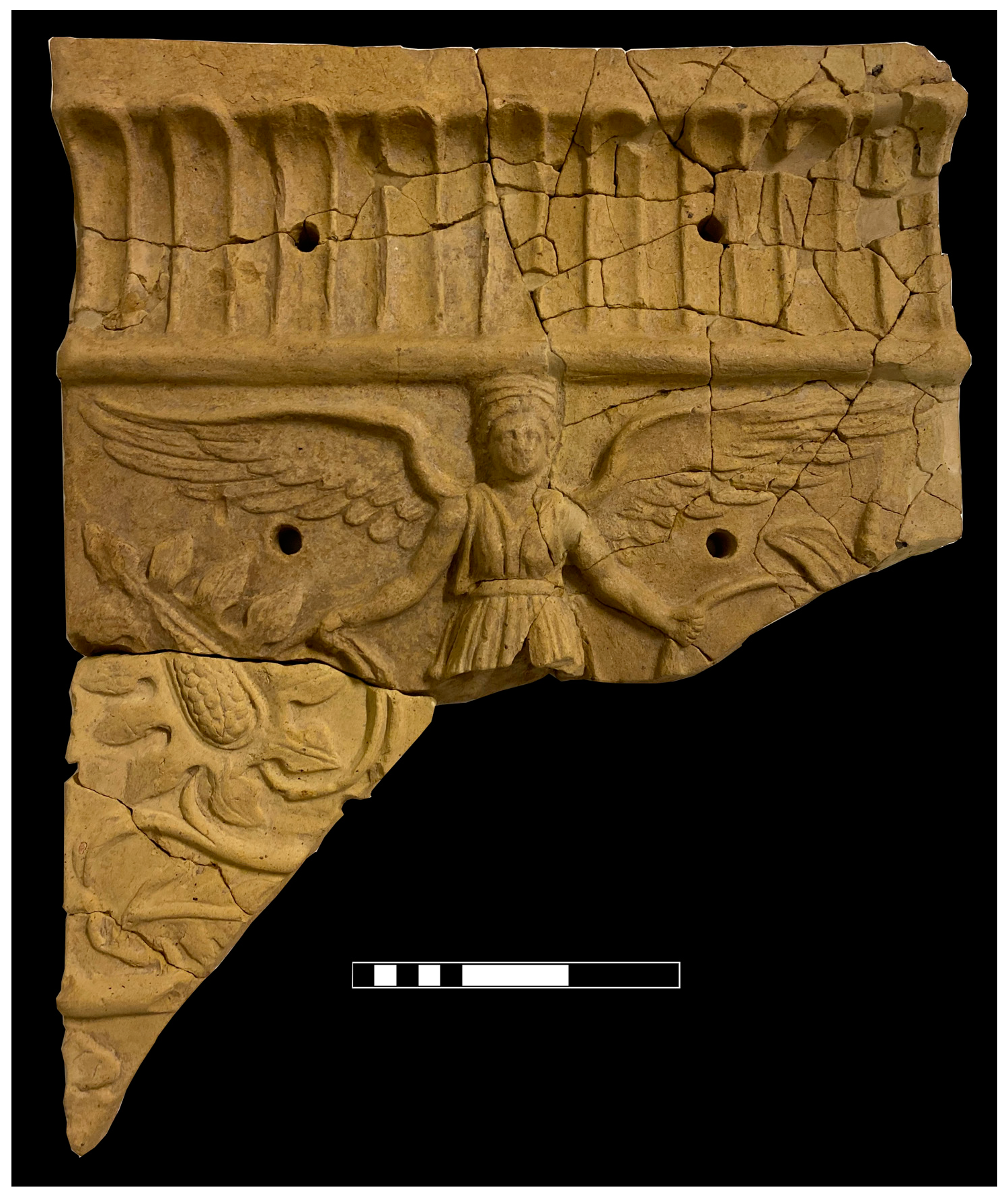
The clay slabs found in Viale Cagliari in 1989 will finally be exhibited and enhanced by the above-mentioned tactile experience. The seven fragments represent two types of iconologies: Nikai, or Winged Victories (Figure 1), and Potnia Theròn, or Rankenfrau (Figure 2). The fragments were found during the excavations conducted in a private estate and are partly re-joinable, decorated with matrix-impressed motifs and good workmanship. The largest and best-preserved fragment of Victories (45 × 35 × 2.5 cm) is made of compact and purified beige–pink clay, which is not very porous and has rare inclusions.
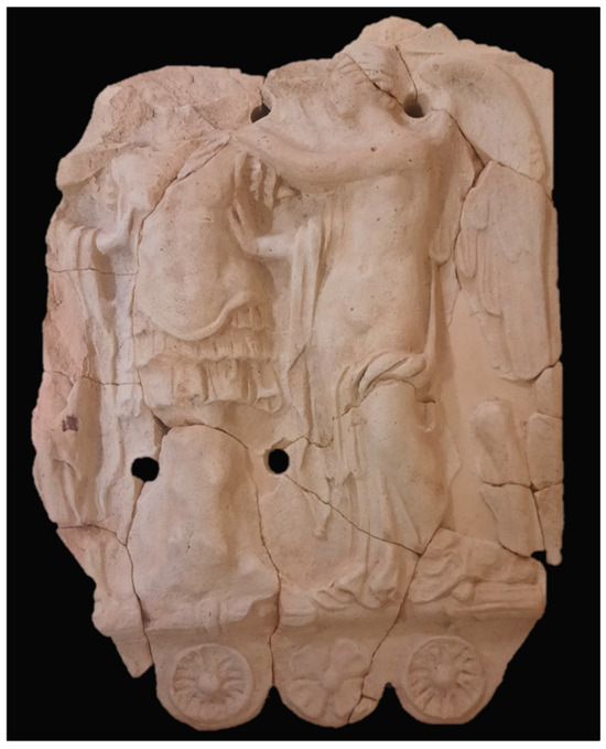
Figure 1.
Territory Museum of Riccione “Luigi Ghirotti”: Architectural terracotta slab with Nikai (Winged Victories).

Figure 2.
Territory Museum of Riccione “Luigi Ghirotti”: Architectural terracotta slab with Rankenfrau.
The central representation is framed by an upper and a lower register. In the upper frame, it is possible to observe the presence of small palms, whereas in the lower one, under a roundel of thunderbolt bundles, four-leafed clovers with heart-shaped petals and umbilical paterae are depicted. In the central part, two Victories placed on either side of a trunk on which they adorn a trophy of arms are depicted. These female figures are winged and half-naked, with one arm outstretched forward and one leg resting, while the other is at rest. The hair of the Victories is parted in the center, and sinuous incisions characterize the locks. The wings, well-defined in their plumage, form a wide curve behind the nape of the figures’ necks and descend along the outer edge of the plate. Below the resting legs of the Victories are two greaves.
As many as five fragments belong to the iconographic subject of the Rankenfrau, of which the best-preserved and largest fragment has been scanned. This is the upper half of the slab, characterized by a strigil frame and a preserved female figure from the head up to the waist height. The subject has outstretched wings across the entire width of the slab. She has massive, open arms and holds two plant shoots in her hands. At the sides of the female figure, supple stems, smooth leaves, and luxuriant inflorescences develop symmetrically, creating a lush vegetal composition [18].
A table and a milestone preserved in the lapidary of the City Museum of Rimini, found in Riccione and in Misano Adriatico, were further subjected to a high-resolution 3D survey. During the process, their informative potential on the Romanization of the territory and the possible use of their replicas in a renewed tour suggested new operations that will be described in Section 3. The marble table that resembles works promoted by Emperor Domitian in AD 93 for the restoration of the Via Flaminia was found in 1774 in Fontanelle (Riccione). This table may have been part of a monument celebrating these interventions, which would justify why the nearby Rio Melo is mentioned as Rivus qui vocatur de Domitiano (river called of Domitian) in a document from the archiepiscopal archives of Ravenna. The emperor’s name was erased following a senate condemnation for damnatio memoriae (condemnation of memory) after his murder in 96 AD.
The milestone of the 211th mile, now on display at the City Museum of Rimini, comes from the Misano Adriatico area. It shows three inscriptions engraved over a period of eighty years, plausibly between 307 and 388. The first one recalls Emperor Maxentius (name partly erased due to damnatio memoriae); one of the two following inscriptions on the back recalls Emperor Constantine, whereas the last one refers to the usurper of the Roman Empire, Magnus Maximus and his son Flavius Victor. It should be noted that only the first inscription is properly functional to the milestone, while the two following ones have propagandistic and celebratory purposes for the figure of Constantine and then the one of Magnus Maximus.
2. Materials and Methods
2.1. Structured Light Projection Scanning and High-Resolution Imagery Acquisition for Texturing
The three-dimensional survey of the artifacts was performed with an integrated, multi-instrument approach. Two different structured light projection scanners were employed to obtain the geometric information (Figure 3), while a mirrorless camera was used to acquire the objects’ texture.
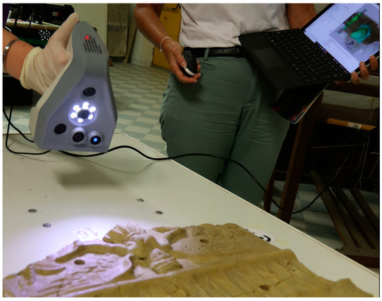
Figure 3.
3D surveying at the Riccione Museum with SLS.
Structured light projection scanning (SLS) is a highly precise geomatic technique designed for the survey of small-to-medium-sized single objects. The typical range for these instruments can reach from a few centimeters up to a maximum of a few meters. Despite the high costs of this equipment, SLS is among the most precise tools within the geomatic techniques and allows for fast acquisition rates. The scanning speed was provided by the hand-held configuration used by most SLS scanners (that permit it to move around the objects easily) and by the real-time acquisition of geometric data. The light pattern (formed by luminous elements distributed in a very tight configuration) was projected onto the objects’ surfaces and deformed by the objects’ geometry; this deformation was acquired by one or more cameras positioned at a known distance, both reciprocally and with respect to the pattern projector, constantly recording a sequence of frames from different positions. The scanner algorithms then calculated then the 3D coordinates of the detected points by analyzing the deviation of the light pattern with respect to its original configuration and performing real-time triangulation on the extracted features [19].
In addition to the SLS survey, high-resolution images were also acquired, with the initial aim being to conduct a photogrammetry-based digital reconstruction to be employed for complex morphology objects and to compare the results, in terms of geometry accuracy, with outcomes of SLS. Digital photogrammetry, nowadays mostly employed to perform a structure-from-motion (SfM)-based digital reconstruction, is an image-based survey technique that allows the acquisition of geometry information by capturing multiple images of an object from different viewpoints. The feature extraction and image-matching processes in the SfM approach are performed by computer vision algorithms that find correspondences between the images employing the information associated with the images in a digital format [20].
The image-based survey was conducted by employing a Sony DSC-RX100M7 mirrorless camera (Sony Corp., Tokyo, Japan) featuring a 20.1 MP, CMOS Exmor RS® 1” sensor. We acquired both nadiral and tilted images of the objects, ensuring an overlap of approximately 80% between consecutive shots, and covering the entire surface of the objects. Working at an acquisition distance of approximately 500 mm and using a nominal focal length of 24 mm, the spatial resolution of the images obtained was approximately 0.05 mm. The acquisition phase took up to 45 min for the most complex objects, due to the need to control and make uniform the scene lighting. At the end of the process, a high level of detail in the images was obtained to represent the visual aspects of the objects clearly and faithfully.
Nonetheless, the range-based technique proved to be effective and exhaustive, even for complex morphology objects, allowing the acquisition of the complete geometry of the scanned surfaces. For this reason, the speed of SLS data acquisition (requiring between 15 and 20 min, depending on the object’s complexity), coupled with the considerable accuracy provided by the instruments (nominally up to 0.05 mm), was preferred to the image-based reconstruction approach. High-resolution images were instead used for the purpose of texturing the geometric data obtained from range-based scanning. Some artifacts were indeed challenging for SLS; however, with some precautions and targeted strategies in the acquisition phase, it was possible to obtain very accurate geometric data (0.1–0.3 mm for all objects). In addition, the materials of the scanned objects (mostly unpolished stone materials, therefore not very reflective and with a rough texture) were cooperative with respect to structured light projection scanning, which may be affected by problems of interactions with the optical properties of the materials, providing incorrect or lacking results. In this case, the artifacts presented the right “requirements” for SLS scanning in terms of size (within the instruments’ ranges), morphology (neither uniform nor extremely complex), and materials (neither reflective nor absorbing).
In conclusion, the strategy adopted consisted of a combined method, opting to use SLS scanning for the geometric data, while high-resolution images (acquired with a photogrammetric scheme) were mainly used to create the texture of the models. This choice was also motivated by the fact that texture frames acquired by SLS scanners underwent an automatic and poorly parameterizable pre-processing phase. This led to the production of textures that were aesthetically pleasing but altered from the actual colorimetric values of the objects. Therefore, combining geometry acquisition with a very high-precision technique and texture creation using realistic, high-definition images appeared to be the most suitable choice for the aims of this project, with it also being a well-tested method applied in other case studies [21].
2.2. An Example of Workflow for the 3D Reconstruction: The “Winged Victories” Decorative Slab
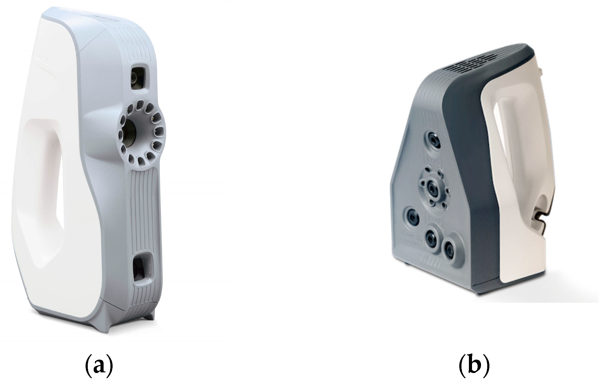
As discussed in Section 2.1, two hand-held structured light projection devices were employed for object geometry acquisition: the “Eva” and “Spider” 3D scanners (Figure 4) manufactured by Artec 3D (Luxembourg, https://www.artec3d.com/ (accessed on 27 December 2024)). The first instrument had a nominal precision of up to 0.1 mm, while the second could reach 0.05 mm. Eva’s acquisition distance range was 40 to 100 cm, while for Spider, it was 20 to 30 cm. This suggests that the Eva scanner was designed for larger objects than those acquirable with Spider, but in contrast, it had slightly poorer precision. In fact, Eva was used to acquire the overall objects’ geometry, while Spider was used for details. The data acquired with the two scanners were then integrated to fill in any gaps in Spider’s scan data, mainly used to obtain more accurate data on the objects’ superficial details.
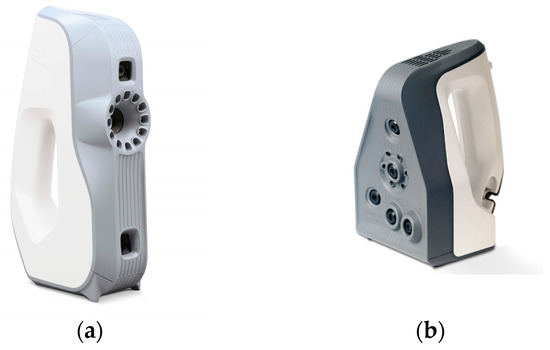
Figure 4.
Artec 3D scanners used in the work: (a) Eva (0.1 mm nominal accuracy); (b) Spider (0.05 mm nominal accuracy).
The 3D survey of the “Winged Victories” slab is reported here as an example of the general workflow adopted. The object was first placed on a flat, unobstructed support that would allow it to rotate and move around. First, the Eva scanner was used to obtain a framing survey of the object’s overall geometry and side edges. Next, a detailed scanning of the topside of the slab, i.e., the figures finely carved in the terracotta (described in Section 1.2), was conducted. The two datasets obtained with the different scanners were then processed using the proprietary software Artec Studio Professional (v.16). First, each individual scan had to be registered separately to ensure proper alignment of the raw geometry frames. Next, the separately registered scans were oriented in the same reference system to reconstruct the entire geometry of the object. If the scan was interrupted and then resumed from a different viewpoint, the data were no longer oriented in the same reference system and had to be co-registered during post-processing. This was accomplished by selecting homologous points between the different scans’ surfaces, which were then finely registered with the software’s alignment tools, which employed an Iterative Closest Point algorithm [22].
After the global registration of the entire dataset, the raw scans were merged to create the final, solid 3D mesh. During this phase, the 3D resolution can be set, providing the final geometrical accuracy of the digital model; the lower this value is, the higher the number of geometrical features represented in the model. For this work, the initial 3D resolution was set to 0.1 mm for all the models to obtain a highly accurate digital reconstruction of the objects; as explained in Section 2.1, high-definition images were acquired to complete the models with a photo-realistic texture. A photo registration algorithm in the above-mentioned proprietary software from Artec 3D was employed to align the images on the geometry model to accomplish this final step. By connecting the image coordinated to the 3D coordinates, the software creates a texture map, associating the correct portions of the image to it homologous points on the 3D mesh (Figure 5).
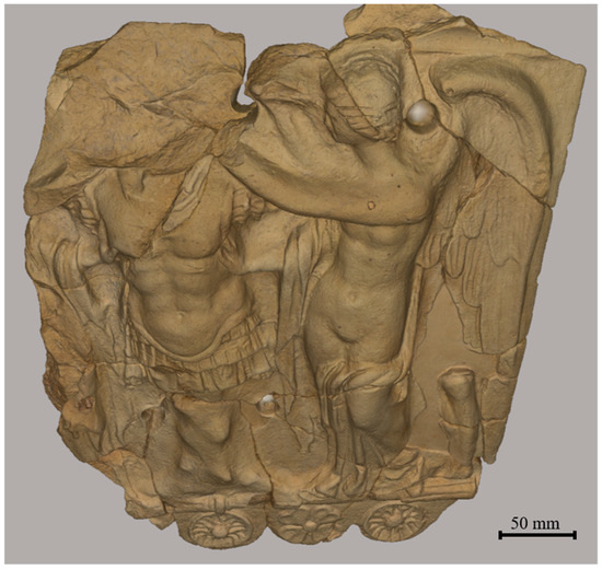
Figure 5.
Textured model of the “Winged Victories” slab.
The creation of textured models was accomplished for representation and study purposes, but for the final aims of the museum project (involving 3D printing for tactile art), this further step was not needed. To deliver a more effective product for 3D printing, the models were also optimized. The optimization procedure involved a global remeshing of all the meshes, restructuring the entire set of polygons that formed the surface of the models. More specifically, this process replaced or redistributed the original polygons to achieve a more uniform and regular configuration across the entire mesh. It ensured that the polygons had a consistent and optimized shape and that their edge lengths were as uniform as possible. This unification eliminated topological irregularities and ensured an even distribution of polygons over the surface. By applying this process globally, the mesh became more coherent and better suited for subsequent operations, such as, in this case, 3D printing (Figure 6). After this final procedure—carried out with the isotropic remeshing algorithm in the Artec 3D software—the 3D resolution of the models was downscaled to 0.3 mm, with it still being sufficient for the purposes of the project (Figure 7).
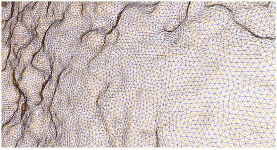
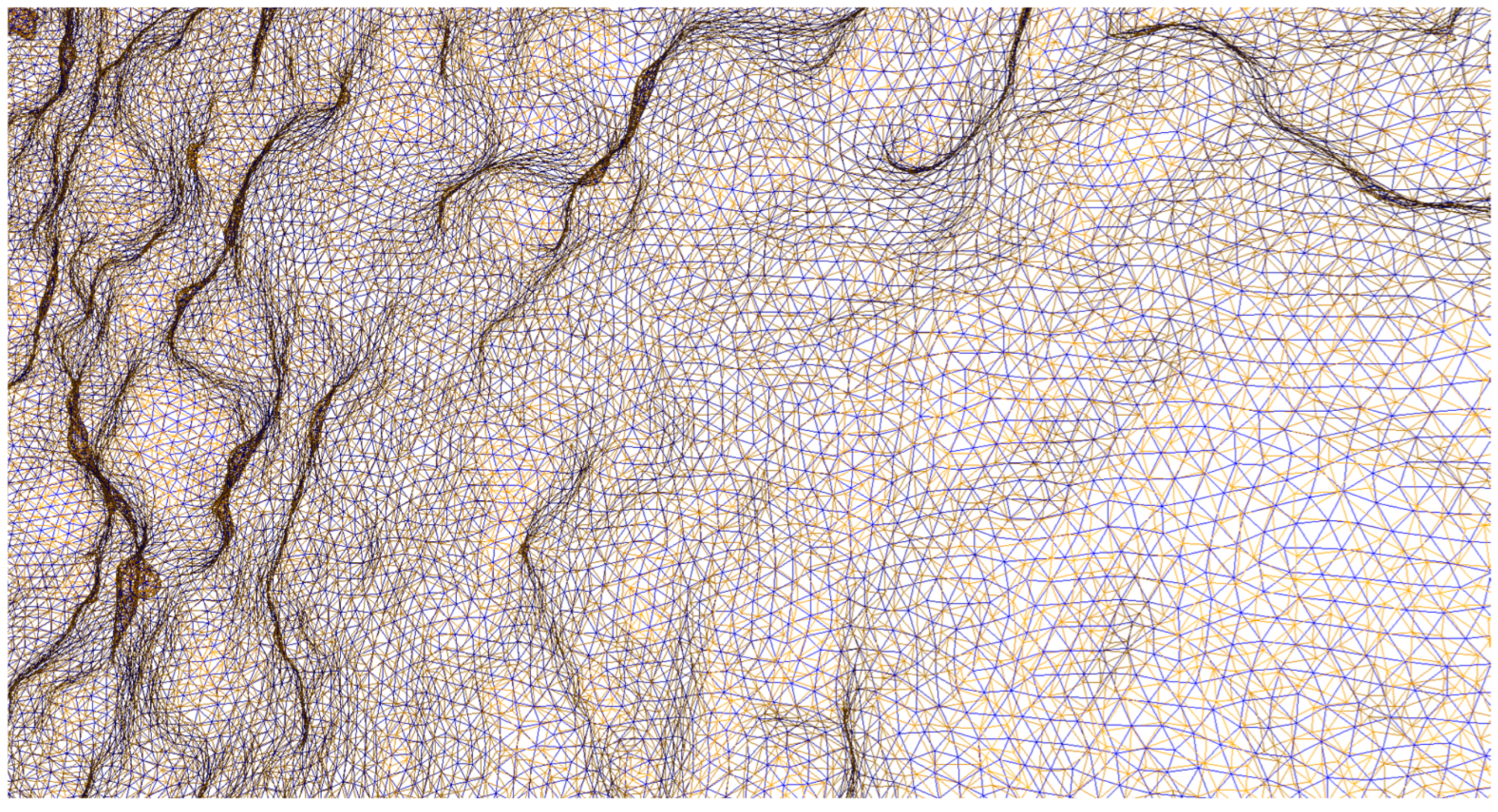
Figure 6.
Before (orange) and after (blue) remeshing, with mesh wireframes superimposed.

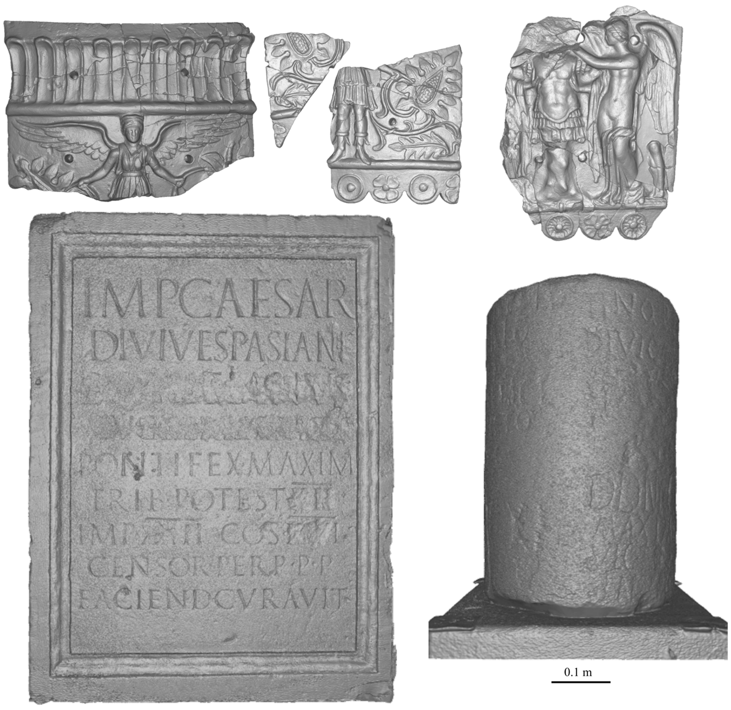
Figure 7.
The final 3D models of all the reconstructed objects. Top: three fragments of the Rankenfrau slab (left) and Winged Victories slab (right); bottom: Damnatio memoriae slab (left) and Miliario (right).
2.3. Post-Processing Operations on the Digital Products Obtained
As already mentioned in the introduction, the 3D models created for the aims of the museum’s project were also employed to carry out post-processing operations, taking advantage of the digital products obtained. This kind of procedure can only be achieved in a digital environment, and the availability of such material was considered an opportunity to test additional tools, with the aim of enhancing the collected dataset. The procedures carried out on three of the surveyed artifacts’ 3D models are described in the following sections.
2.3.1. Damnatio Memoriae Marble Table—Engraving Reconstruction
The marble table conserved in the Rimini Museum was considered an interesting case study due to the presence of a “Damnatio Memoriae”, i.e., an erased part in the surface engravings. It was decided to experiment with procedures to recover the erased words to confirm the interpretation of the historians who had reconstructed the missing part through visual inspection and literature research [23]. When observing the 3D model (presenting a 0.1 mm 3D resolution) of the table from the back side, it was noticed that the cleavage left by the engravings was more visible than on the front side, where the abrasion had instead compromised legibility.
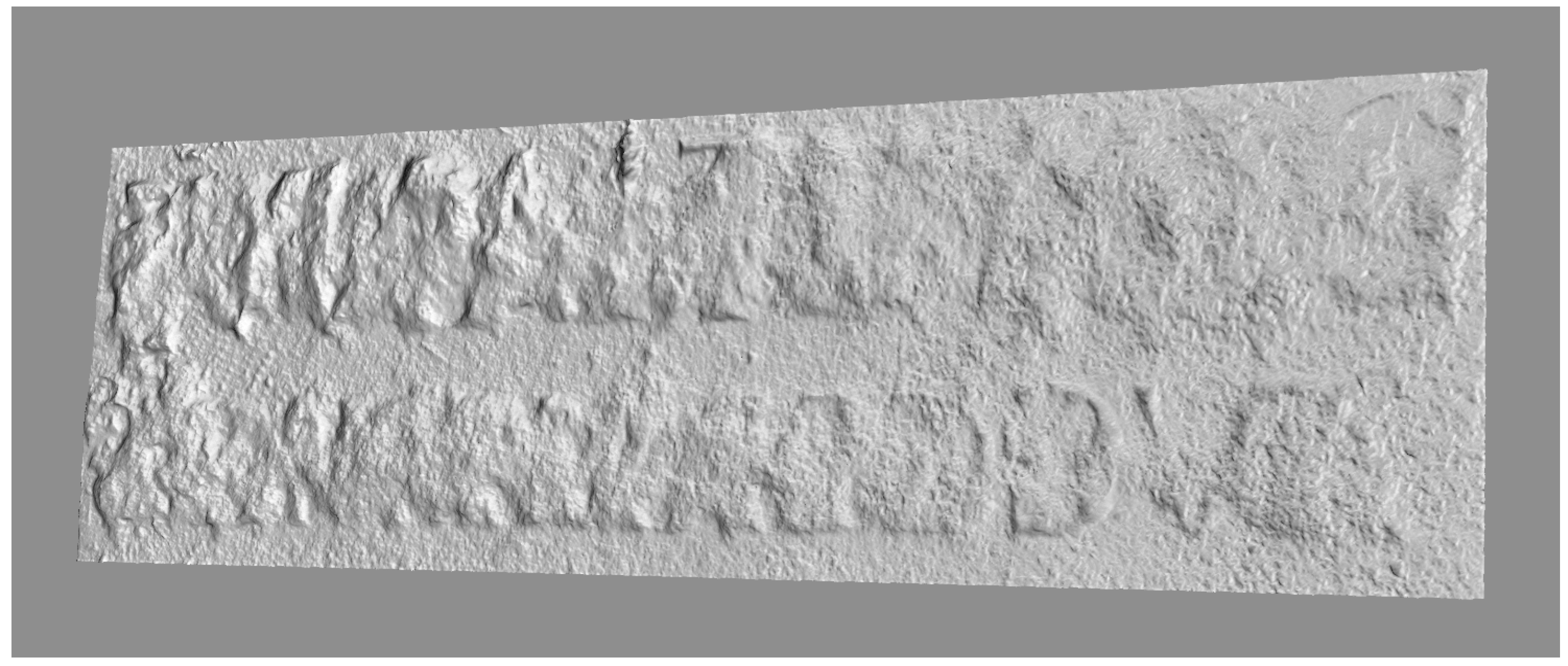
To further improve the legibility of the letters, it was decided to emphasize the surface of the models. Various lighting models were applied with different settings and in other platforms, and the best result was obtained with the “Eye Dome Lightning” shader (Figure 8) provided by the CloudCompare software (www.cloudcompare.org (accessed on 27 December 2024).). With this model, a series of lights were virtually projected onto the model from multiple angles, allowing the contours of the letters to be revealed by directing the light to the point of interest [24]. Through this method, the missing letters in the table due to damnatio memoriae could be observed, and the original writing could be reconstructed.
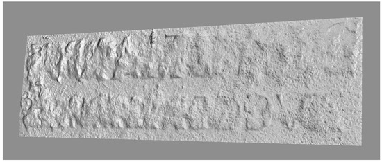
Figure 8.
“Eye Dome Lightning” shader applied to the slab 3D model.
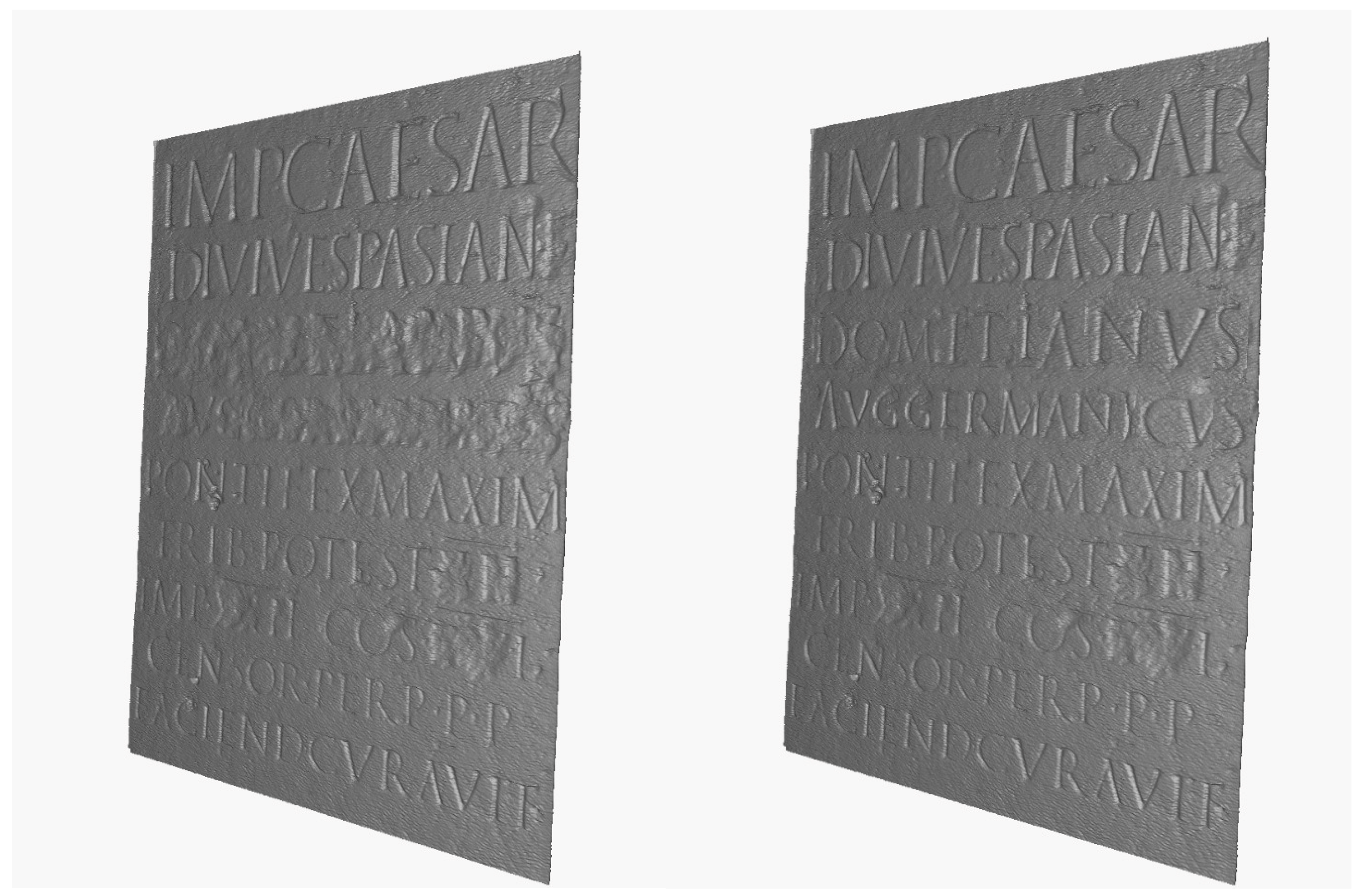
To complete the experiment, the missing parts were extracted from the areas of the model where the needed letters were present in other words inside the inscription. These were then aligned in the correct position, using the cleavage left by the abraded letters as references. An additional 3D mesh was then produced, in which the erased portion was replaced by the words originally present in the table, i.e., the name of the emperor (“Domitianus Aug. Germanicus”) whose memory was to be erased. A comparison of the before and after of the marble table digital model is shown in Figure 9.
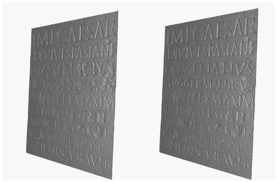
Figure 9.
“Damnatio Memoriae” slab: before and after digital reconstruction of the erased letters.
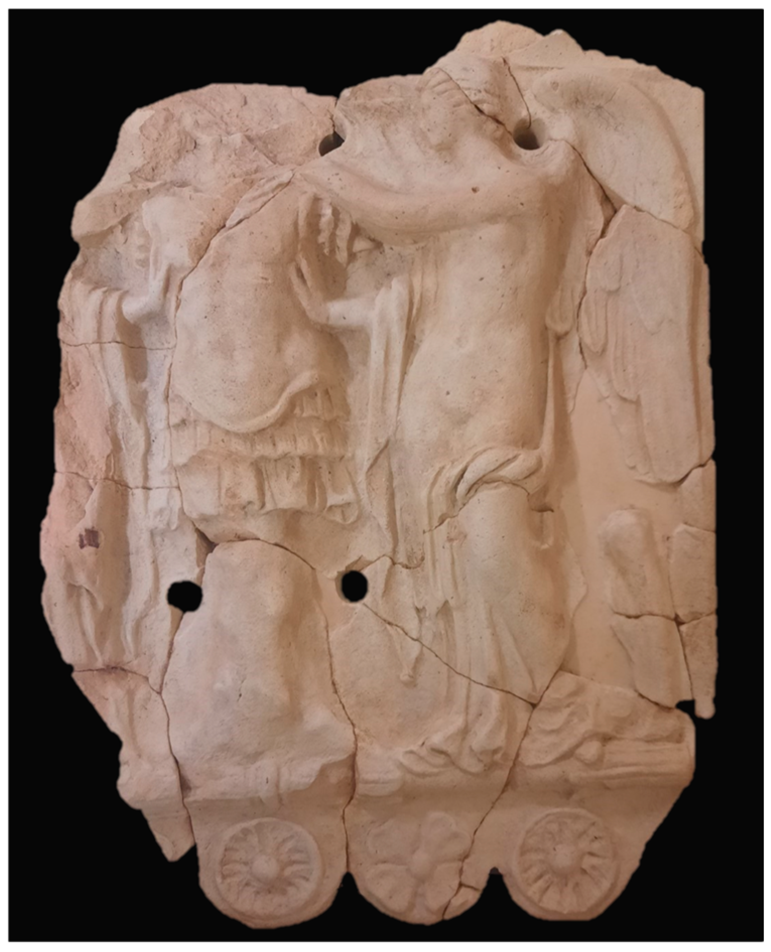
2.3.2. Potnia Theròn Slab Digital Restoration
Among the decorative terracotta slabs conserved in the Riccione Museum, three slabs representing the iconology of the deity “Potnia Theròn” were present. Two of the selected objects were inspected visually, and it seemed evident that they were detached portions of a unique slab, probably broken during manufacturing or transportation. Therefore, it was decided to conduct a virtual restoration operation for the two slabs, connecting them digitally to recover the original condition of the object.
First, the two models were both correctly positioned along their X, Y, and Z axes. Then, a manual alignment was performed by translating the smaller slab until there was a complete adhesion to the border of the bigger slab. In this case, it was not possible to proceed with the homologous point alignment method or with the ICP algorithm, with the two models being representative of two distinct parts of the object, without any feature being present in them both. Therefore, the co-registration was performed manually, and the two meshes were then merged to create a single, continuous 3D model, reconstructing the slab as it was before the fracture (Figure 10).
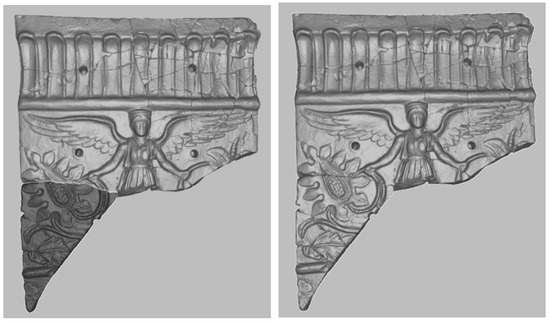
Figure 10.
Potnia Theròn slab virtual restoration—before (left) and after (right) the fusion of the detached slab fragments’ 3D models.
2.3.3. Milestone Geometric Projection
The milestone conserved in the Rimini Museum was considered a further case for conducting post-processing operations. The object, described in session 1.2, was considered geometrically as a cylinder. Therefore, it was decided to proceed with a geometric projection of its lateral surface, which had poorly legible incisions due to its state of preservation. This operation allowed for an improvement in the legibility of an artifact that was in a non-planar form by projecting the various engraved elements in sequence onto a flat surface [25]. The procedure was carried out by first fitting a geometric primitive of a cylinder to the milestone 3D model to extract accurate values of the radius (needed to proceed with the unrolling); after that, CloudCompare software was used to perform the unrolling of the lateral surface by setting the correct values of the cylinder radius and the rotation angle, along which the unrolling was conducted.
After the operation was completed, a dense point cloud was obtained (the software used can only geometrically project point clouds, so the operation was performed considering the mesh vertexes), which was then converted into a solid mesh again in MeshLab software (www.meshlab.net (accessed on 27 December 2024)), using the ball-pivoting surface reconstruction algorithm [26]. Moreover, having applied a digital lighting model to emphasize the lines of the engravings, it was noticed that the writings could be read from a fixed viewpoint for the unrolled surface, while for the non-unrolled model, it was necessary to rotate and enlarge the object model while also adjusting the direction of the lights. Figure 11 shows an example of the difference between the unrolled surface (right), compared with the same portion of the milestone model before the geometric projection (left). As can be seen, applying the same shader (“glass shader” in MeshLab software), the words “Maximo” can be read clearly and at once, only in the unrolled mesh.
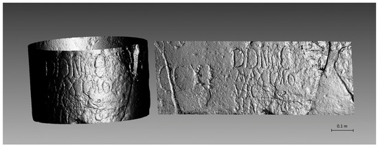
Figure 11.
A portion of the milestone 3D model before (left) and after (right) unrolling.
3. Discussion
This paper reports a methodology employed for a 3D detailed survey of museum assets and post-processing operations conducted on the digital products obtained. The processes adopted produced accurate results, both from the geometric and from the colorimetric points of view. The accuracy of the models obtained fully met the requirements of the museum and ensured a faithful representation of the morphology of the scanned objects. This aligns with the museum project’s ultimate goals, which will be to 3D print the obtained models for tactile art purposes for museum inclusivity strategies. The level of detail obtained will allow replicas to be printed at a very high resolution (down to 0.1 mm, depending on the printer used), and this is crucial in a project where the tactile perception of surface details of objects must be very realistic. In addition, all the post-processing operations conducted as experiments for this work were realized using open-source and/or free software.
On the other hand, there was no lack of challenges and difficulties in the digitization and data processing workflow. For example, some objects (especially the ‘Winged Victories’ slab) had occluded parts and a rather complex geometry, which required special attention to be able to digitize even the less visible areas hidden by other elements. Furthermore, as for the ‘Damnatio memoriae’ slab and the milestone, these objects were exhibited outside in the courtyard of the museum in Rimini, surrounded by vegetation. In this case, it was rather challenging to completely cover the objects with scanners and photos, and it was necessary to work during post-processing to eliminate outliers. A further difficulty was the presence of uneven lighting, both inside and outside, which led to some problems in acquiring high-resolution images for the texture. In some cases, where possible, portable lights were used to try to even out the lighting as much as possible.
All these challenging aspects were addressed with careful attention to methodological rigor and a focus on the accuracy of the digital reconstruction, using a geomatic approach. It should be noted that high-precision and high-detail 3D surveying (with sub-millimeter accuracies and resolutions) is not widely discussed in scientific literature, especially when applied to small archaeological objects. Additionally, some post-processing steps—particularly the reconstruction of missing parts due to Damnatio Memoriae, made possible by the very high level of geometric detail achieved—are quite unusual in this field. Therefore, this article aimed to explore the potential of high-detail, high-precision 3D surveying in cultural heritage, not only for reliable digital documentation but also, more importantly, for its analysis, enhancement, and preservation.
In addition, the operations conducted required a strong knowledge of 3D modeling procedures and of the algorithms used; similarly, historical/archaeological expertise was needed throughout the entire operation to ensure the correctness of the procedures and to analyze and interpret the digital outcomes. This consideration was pivotal, and the results obtained confirmed that a multidisciplinary approach is fundamental in the digitization field, especially in the delicate context of cultural heritage assets.
4. Conclusions and Future Perspectives
To conclude, it can be said that the results of this work, in which high-precision surveying methods were applied with well-established and tested strategies, are promising for the future of 3D scanning applied to museum assets. Indeed, with this paper, it has been underlined that geomatics and museology together can produce great results to improve the dissemination of cultural heritage and offer new strategies in terms of storytelling and inclusiveness for museum visitors.
As the next developments, further strategies will be explored to conduct the reported or other digital operations, and more work will be carried out to validate the experiments with additional tests and comparisons. Furthermore, a comparison between photogrammetry and structured light projection scanning could be conducted to align with the present literature on the evaluation of the geometric restitution accuracy of different sensing techniques [27].
As for the Riccione Museum project, the models obtained with the methodology reported will be 3D printed and showcased within the museum collection to be touched by visually impaired visitors. In the future, this tactile experience could be investigated to evaluate the impact of this strategy on visitors’ experiences. Moreover, the 3D-printed replicas could be assessed in terms of geometrical accuracy, for instance by 3D scanning, and comparing their digital models to the original 3D models. As reported in the literature [28], this strategy could be an option to evaluate the impact of 3D printing processes on preserving geometrical accuracy.
Author Contributions
Conceptualization, G.B., A.F. and A.T.; methodology, G.B., A.F. and M.A.T.; validation, A.F. and M.A.T.; investigation, A.T. and F.B.; writing—review and editing, A.F. and G.B.; supervision, G.B.; funding acquisition A.T. All authors have read and agreed to the published version of the manuscript.
Funding
This research was partially funded by the Directorate General of Museums as per Decree No. 1220 on 23 December 2021, which allocated contributions provided under the Ministerial Decree on 28 January 2021, No. 62.
Data Availability Statement
The datasets presented in this article belong to the Territory Museum of Riccione “Luigi Ghirotti”, to which any requests for access to the datasets must be addressed.
Acknowledgments
The authors wish to express their gratitude to Giovanni Sassu, Director of the City Museum of Rimini and Kevin Ferrari and Annalisa Pozzi, officials of the Superintendency of Archaeology, Fine Arts, and Landscape for the Provinces of Ravenna, Forlì-Cesena, and Rimini. Many thanks also to the staff of the Territory Museum of Riccione for their valuable support and contributions.
Conflicts of Interest
The authors declare no conflicts of interest.
References
- Pavlidis, G.; Koutsoudis, A.; Arnaoutoglou, F.; Tsioukas, V.; Chamzas, C. Methods for 3D Digitization of Cultural Heritage. J. Cult. Herit. 2007, 8, 93–98. [Google Scholar] [CrossRef]
- Bitelli, G.; Girelli, V.A.; Remondino, F.; Vittuari, L. The Potential of 3D Techniques for Cultural Heritage Object Documentation. In Proceedings of the SPIE—The International Society for Optical Engineering, IX—SPIE-IS&T Electronic Imaging, San Jose, CA, USA, 28 January–1 February 2007; Volume 6491, pp. 244–253. [Google Scholar] [CrossRef]
- Bitelli, G.; Borghi, B.; Francolini, C.; Galletti, F. New Hypotheses and Interpretations Regarding the Longobard Basin in the “Jerusalem” of Bologna Supported by 3D Surveying Methodologies. J. Cult. Herit. 2020, 46, 226–234. [Google Scholar] [CrossRef]
- Pendić, J.; Molloy, B. The Use of 3D Documentation for Investigating Archaeological Artefacts. In The 3 Dimensions of Digitalised Archaeology; Hostettler, M., Buhlke, A., Drummer, C., Emmenegger, L., Reich, J., Stäheli, C., Eds.; Springer: Cham, Switzerland, 2024; pp. 9–26. [Google Scholar] [CrossRef]
- Tucci, G.; Bonora, V.; Conti, A.; Fiorini, L. High-Quality 3D Models and Their Use in a Cultural Heritage Conservation Project. Int. Arch. Photogramm. Remote Sens. Spatial Inf. Sci. 2017, XLII-2/W5, 687–693. [Google Scholar] [CrossRef]
- Balzani, R.; Barzaghi, S.; Bitelli, G.; Bonifazi, F.; Bordignon, A.; Cipriani, L.; Colitti, S.; Collina, F.; Daquino, M.; Fabbri, F.; et al. Saving Temporary Exhibitions in Virtual Environments: The Digital Renaissance of Ulisse Aldrovandi—Acquisition and Digitisation of Cultural Heritage Objects. Digital Appl. Archaeol. Cult. Herit. 2023, 32, e00309. [Google Scholar] [CrossRef]
- Pérez, M.; Casanova-Salas, P.; Twardo, P.; León, A.; Mladenic, D.; Massri, B.M.; Troncy, R.; Ehrhart, T.; Cicero, G.L.; Vitella, M.; et al. From Historical Silk Fabrics to Their Interactive Virtual Representation and 3D Printing. Sustainability 2020, 12, 7539. [Google Scholar] [CrossRef]
- Kantaros, A.; Soulis, E.; Alysandratou, E. Digitization of Ancient Artefacts and Fabrication of Sustainable 3D-Printed Replicas for Intended Use by Visitors with Disabilities: The Case of Piraeus Archaeological Museum. Sustainability 2023, 15, 12689. [Google Scholar] [CrossRef]
- Parfenov, V.; Igoshin, S.; Masaylo, D.; Orlov, A.; Kuliashou, D. Use of 3D Laser Scanning and Additive Technologies for Reconstruction of Damaged and Destroyed Cultural Heritage Objects. Quantum Beam Sci. 2022, 6, 11. [Google Scholar] [CrossRef]
- Fragkos, S.; Tzimtzimis, E.; Tzetzis, D.; Dodun, O.; Kyratsis, P. 3D Laser Scanning and Digital Restoration of an Archaeological Find. MATEC Web Conf. 2018, 178, 03013. [Google Scholar] [CrossRef]
- Liu, S.; Tu, Y.; Wang, X.; Qin, B.; Xie, Z.; Zhang, Y.; Zhang, H.; Hu, D. Transparent Reversible Prosthesis, a New Way to Complete the Conservation–Restoration of a Black Ding Bowl with Application of 3D Technologies. Herit. Sci. 2022, 10, 14. [Google Scholar] [CrossRef]
- Dellepiane, M.; Callieri, M.; Fondersmith, M.; Cignoni, P.; Scopigno, R. Using 3Dscanning to analyze a proposal for the attribution of a bronze horse to Leonardo da Vinci. In Proceedings of the 8th International Symposium on Virtual Reality, Archaeology and Cultural Heritage, Brighton, UK, 26–30 November 2007; pp. 117–124. [Google Scholar] [CrossRef]
- Di Martino, A.; Cannizzaro, F.; Cocuzza Avellino, G.; Impollonia, F. New Low-Cost Rolling Ball Type Isolation Device for the Protection of Museum Collections. In Transdisciplinary Multispectral Modeling and Cooperation for the Preservation of Cultural Heritage; Moropoulou, A., Georgopoulos, A., Ioannides, M., Doulamis, A., Lampropoulos, K., Ronchi, A., Eds.; Springer: Cham, Switzerland, 2023. [Google Scholar] [CrossRef]
- Patrucco, G.; Bambridge, P.; Giulio Tonolo, F.; Markey, J.; Spanò, A. Digital Replicas of British Museum Artifacts. Int. Arch. Photogramm. Remote Sens. Spat. Inf. Sci. 2023, XLVIII-M-2–2023, 1173–1180. [Google Scholar] [CrossRef]
- Krumpen, S.; Klein, R.; Weinmann, M. Towards Tangible Cultural Heritage Experiences—Enriching VR-Based Object Inspection with Haptic Feedback. J. Comput. Cult. Herit. 2022, 15, 1–17. [Google Scholar] [CrossRef]
- D’Agnano, F.; Balletti, C.; Guerra, F.; Vernier, P. Tooteko: A Case Study of Augmented Reality for an Accessible Cultural Heritage. Digitization, 3D Printing and Sensors for an Audio-Tactile Experience. Int. Arch. Photogramm. Remote Sens. Spat. Inf. Sci. 2015, XL-5/W4, 207–213. [Google Scholar] [CrossRef]
- Bruns, A.; Spiesberger, A.; Triantafyllopoulos, A.; Müller, P.; Schuller, B. “Do Touch!”—3D Scanning and Printing Technologies for the Haptic Representation of Cultural Assets: A Study with Blind Target Users. In Proceedings of the 5th Workshop on Analysis, Understanding and Promotion of Heritage Contents, Ottawa, ON, Canada, 2 November 2023. [Google Scholar] [CrossRef]
- Belfiori, F. Due Serie di Lastre Fittili Figurate dal Riminese: Problemi di Cultura Figurativa ad Ariminum fra Mario e Silla. ArchClass 2024, 75, 167–212. [Google Scholar]
- MacDonald, L.; Bentkowska-Kafel, A. Digital Techniques for Documenting and Preserving Cultural Heritage; Arc Humanities Press: Yorkshire, UK, 2018; Available online: https://muse.jhu.edu/book/80843 (accessed on 27 December 2024).
- Schonberger, J.L.; Frahm, J.-M. Structure-from-Motion Revisited. In Proceedings of the 2016 IEEE Conference on Computer Vision and Pattern Recognition (CVPR), Las Vegas, NV, USA, 12 December 2016; pp. 4104–4113. [Google Scholar] [CrossRef]
- Forte, A.; Orefici, G.; Bitelli, G. 3D Survey and Data Processing of Bolivian Archaeology: The Ritual Receptacle from Tiwanaku. Int. Arch. Photogramm. Remote Sens. Spat. Inf. Sci. 2023, XLVIII-M-2–2023, 587–592. [Google Scholar] [CrossRef]
- Besl, P.J.; McKay, N.D. A Method for Registration of 3-D Shapes. IEEE Trans. Pattern Anal. Mach. Intell. 1992, 14, 239–256. [Google Scholar] [CrossRef]
- Donati, A. Rimini Antica: Il Lapidario Romano; Ramberti Arti Grafiche: Rimini, Italy, 1981. [Google Scholar]
- Boucheny, C. Visualisation Scientifique Interactive de Grands Volumes de Données: Pour Une Approche Perceptive. Ph.D. Thesis, Université Joseph Fourier, Grenoble, France, 2009. [Google Scholar]
- Liu, Y.; Zhang, B.; Wan, L. Automatically Unrolling Decorations Painted on 3D Pottery. In Proceedings of the Computer Graphics International Conference, Yokohama, Japan, 27–30 June 2017; ACM: New York, NY, USA; pp. 1–6. [Google Scholar] [CrossRef]
- Bernardini, F.; Mittleman, J.; Rushmeier, H.; Silva, C.; Taubin, G. The Ball-Pivoting Algorithm for Surface Reconstruction. IEEE Trans. Vis. Comput. Graph. 1999, 5, 349–359. [Google Scholar] [CrossRef]
- Barszcz, M.; Montusiewicz, J.; Paśnikowska-Łukaszuk, M.; Sałamacha, A. Comparative Analysis of Digital Models of Objects of Cultural Heritage Obtained by the “3D SLS” and “SfM” Methods. Appl. Sci. 2021, 11, 5321. [Google Scholar] [CrossRef]
- Balletti, C.; Ballarin, M. An Application of Integrated 3D Technologies for Replicas in Cultural Heritage. ISPRS Int. J. Geo-Inf. 2019, 8, 285. [Google Scholar] [CrossRef]


Disclaimer/Publisher’s Note: The statements, opinions and data contained in all publications are solely those of the individual author(s) and contributor(s) and not of MDPI and/or the editor(s). MDPI and/or the editor(s) disclaim responsibility for any injury to people or property resulting from any ideas, methods, instructions or products referred to in the content. |
© 2025 by the authors. Licensee MDPI, Basel, Switzerland. This article is an open access article distributed under the terms and conditions of the Creative Commons Attribution (CC BY) license (https://creativecommons.org/licenses/by/4.0/).