Article

Integrating Building Information Modeling for Enhanced Efficiency and Sustainability in Public Construction: The Sapienza University Protocol

1
School of Architecture and Design, University of Camerino, 62032 Camerino, Italy
2
Department of History, Representation and Restoration of Architecture, Sapienza University of Rome, 00185 Roma, Italy
3
Department of Civil, Constructional and Environmental Engineering, Sapienza University of Rome, 00185 Roma, Italy
*
Authors to whom correspondence should be addressed.
Heritage 2025, 8(4), 114; https://doi.org/10.3390/heritage8040114
Submission received: 20 February 2025 / Revised: 15 March 2025 / Accepted: 21 March 2025 / Published: 24 March 2025

Abstract

:
BIM represents a significant step towards digitalization and innovation in the public construction sector in Italy, and as of 1 January 2025, its adoption became mandatory for all public work. Recognizing the importance of this shift, the Sapienza University of Rome developed a set of standards and guidelines between 2018 and 2024. These guidelines have now been officially adopted by the Buildings Maintenance Area of Sapienza for the application of BIM in service and work contracts. They are consolidated into a document known as the Sapienza Protocol, which serves as a reference for the creation of information-rich models of university heritage buildings, encompassing both existing structures and those to be constructed from scratch. The Sapienza Protocol outlines a modeling process that integrates surveying, geometric modeling, and an informational framework, combining theoretical principles with methodological approaches tested in the HBIM research domain. This approach ensures that both the technical and historical characteristics of buildings are appropriately represented. The purpose of this manuscript is to describe the evolution of the Sapienza Protocol, from its initial version to its current form. It highlights operational procedures and technical solutions, showcasing how the protocol has adapted to address the complex needs of managing and preserving architectural heritage in a digital context.

1. Introduction

1.1. BIM for Public Procurement on Built Heritage

A recent report on the construction industry by the Argenta Research Center SOA [1] highlights that, despite a general economic slowdown driven largely by a global context of geopolitical tensions and conflicts, the construction sector, particularly in Italy, remains one of the main drivers of economic growth. In recent years, construction-related economic activities have recorded a 33% increase in their added value—significantly surpassing the manufacturing and service sectors. Within this framework, a substantial contribution comes from public non-residential construction, encompassing publicly owned buildings designated for institutional use, such as the extensive real estate portfolio of the Sapienza University of Rome.
In the context of advancing green policies, there is a growing emphasis on compliance with ESG (environmental, social, governance) criteria, which provide a framework for measuring an organization’s environmental, social, and governance-related performance [2]. These criteria translate into a set of operational procedures and best practices that guide the activities of companies—and public administrations alike—towards achieving objectives in environmental impact reduction, social responsibility, and governance quality and ethics.
This shift aligns with the progressive implementation of Italy’s new Public Procurement Code (Legislative Decree 36/2023 [3]), which requires public administrations to adopt digital information management methods and tools, commonly referred to as BIM processes, in which the “M” stands for Model and modeling but—most of all—management [4]. To maximize environmental and construction sustainability, it is clear that collective efforts must prioritize the existing building stock, much of which suffers from significant degradation, low energy efficiency, and poor environmental health. A notable challenge arises when dealing with historic buildings, where conventional BIM approaches for new constructions prove inadequate, particularly in developing models that capture not only geometric complexity but also the semantic and technical–construction stratification of these structures.
This has led to the adoption of HBIM (Historic or Heritage BIM), where specific phases of the process are tailored to the unique characteristics of individual historic buildings, especially those of architectural and cultural significance. Attempts to apply optimization methods developed for new constructions or non-historic existing buildings often fail to address these specific challenges. After an initial period of experimentation with varying outcomes, the scientific community has begun to define shared and effective HBIM criteria. These are based on genuine multidisciplinary collaboration and interoperability [5,6]. This ensures that digital information management serves as a foundational tool not only for the maintenance of building stock but also for optimizing all construction activities aimed at rehabilitation or preservation—from intervention planning to execution and final testing.
Some public institutions foresaw this challenge: they recognized the need to ensure that multiple models could “speak the same language,” providing consistent information to clients [7,8,9] (Singapore BIM guide—Version 2.0; New York BIM Guidelines -2012; The VA BIM guide (USA Department of Veterans Affairs)). In this context, Italian and international universities are contributing to transforming standards for the management of built heritage, fostering collaborative approaches supported by advanced technologies [10,11]. The experiments conducted are not limited to meeting new regulatory requirements but aim to define replicable methodologies based on the standardization of processes. Universities have initiated projects in the field of BIM applied to the management of their building assets, recognizing this methodology as a powerful tool to enhance efficiency and sustainability in management processes. The University of L’Aquila and the University of Catania [12,13] have undertaken a digitalization process for their buildings, selecting pilot cases within their campuses to define a protocol aimed at improving the maintenance and management of structures using digital models. These models allow for the storage, organization, and sharing of detailed information about the buildings. The University of Turin, on the other hand, has developed a methodology that integrates BIM and GIS data through a platform enabling real-time visualization of university buildings and their attributes, overcoming the current fragmented and document-based management approach [14,15].
These projects, while differing in their operational details, share with the present research the common goal of transforming the management of built heritage through digital innovation, promoting information sharing and collaboration.
The Sapienza University of Rome, which owns a substantial and architecturally significant building portfolio, has embarked on a comprehensive HBIM digitization initiative. The preliminary phase of integrated digital surveying has been carefully planned and implemented alongside the development of enriched digital models. This approach aims to establish an operational methodology, summarized in a technical programmatic document, to monitor both the quantity and quality of the digitization outputs. This will, in subsequent phases, facilitate the optimization of information management and the processes of efficiency improvement, rehabilitation, and preservation of Sapienza’s entire building stock, in alignment with European and national regulatory directives.

1.2. Manuscript Structure

The following paragraphs outline the evolution of the BIM protocol for the Sapienza University’s real estate, tracing its development from its initial conception to the version adopted by the Building Management Area (Area Gestione Edilizia, AGE). Section 1.3 of Paragraph 1 introduces the case study.
Building on the case study, Paragraph 2 (Materials and Methods) analyzes the first two versions of the protocol, emphasizing their key features. Section 2.1 examines the initial version, which was conceived purely as a research initiative. Section 2.2 discusses the second version, designed to bridge research objectives with practical management needs.
Paragraph 3 focuses on the research results, evaluating the protocol’s effectiveness through its application in digitizing Sapienza’s real estate assets. Section 3.1 and Section 3.2 address the initial stages of the digitization process, including historical research, 3D surveying, and survey verification workflows. Section 3.3 discusses the third and final version of the protocol. Section 3.4 evaluates the verification of BIMs against the protocol’s guidelines.
Finally, Paragraph 4 provides a comprehensive assessment of the entire process, from defining standards through the protocol to applying them in the digitization of Sapienza’s assets.

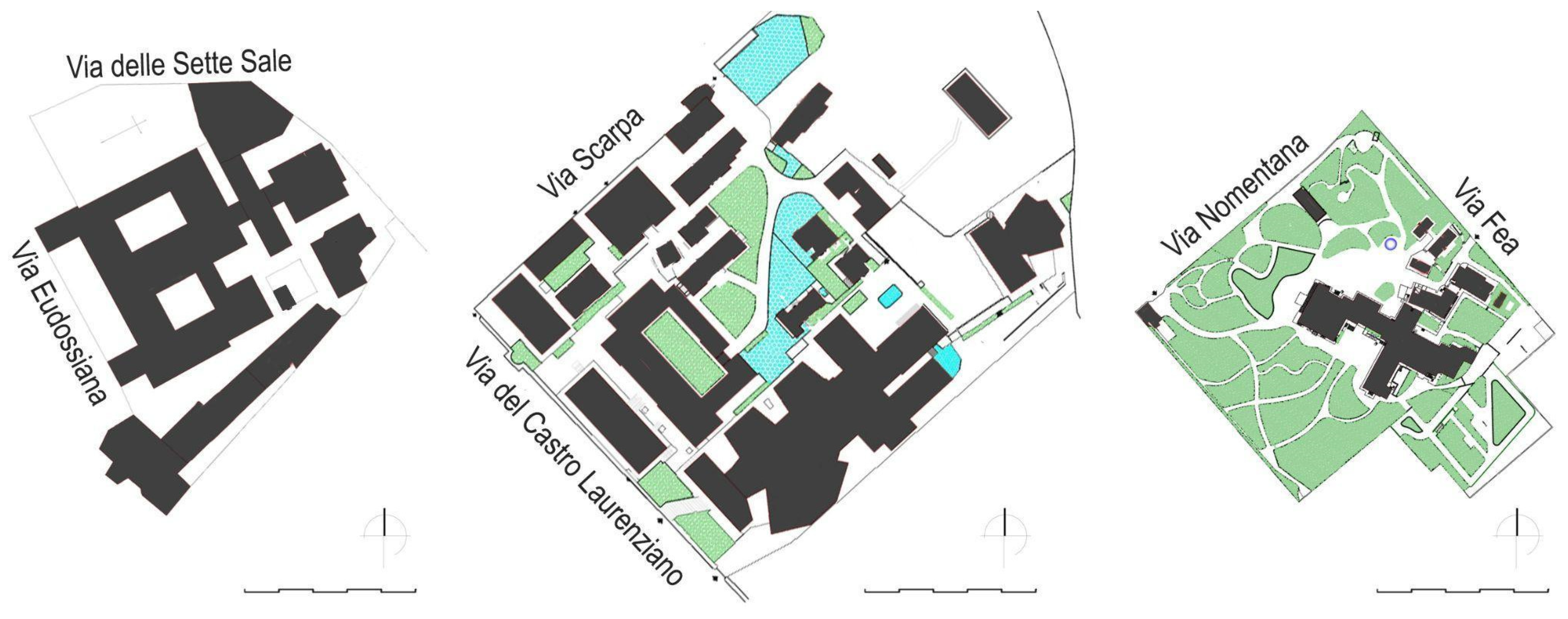
1.3. Sapienza Real Estate Asset

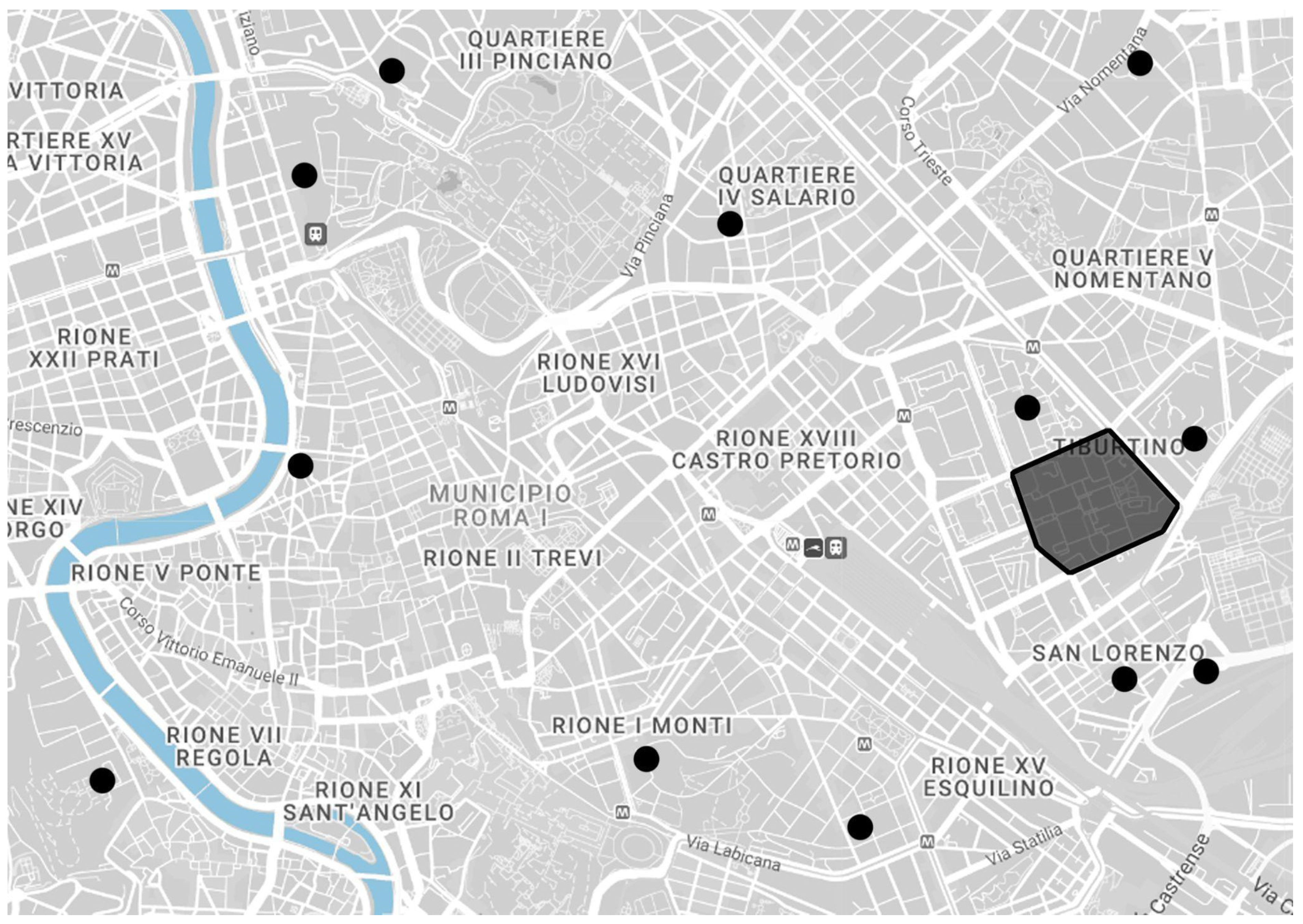
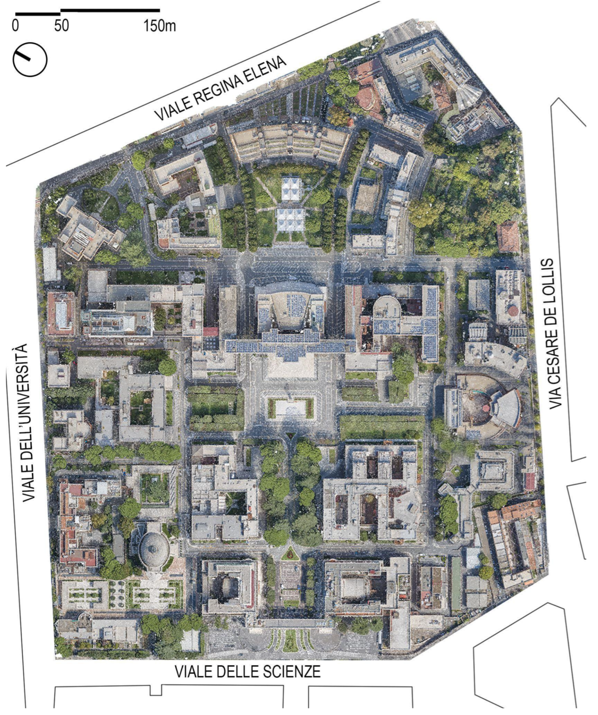
1.3.1. Sapienza Real Estate and University Campus

The Sapienza University of Rome is the largest public university in Europe and one of the most prestigious in Italy. Founded in 1303, it boasts a long academic and scientific tradition, conducting research in the humanities, technology, medicine, and social sciences. As a public institution, it owns an extensive real estate portfolio, primarily concentrated within the University City, but also encompassing dozens of properties—some of significant monumental value—scattered across diverse urban contexts (Figure 1).
These properties reflect the university’s centuries-old history and its evolving role in Italian society. The city of Rome, along with the provinces of Rieti, Viterbo, and Latina, hosts more than 200 university buildings, covering a total area exceeding 650,000 square meters, making Sapienza’s real estate portfolio the largest university estate in Europe. This vast portfolio is both a strategic resource and a significant responsibility for the Sapienza. As a public administration entity, the university is tasked with managing, maintaining, and, where possible, renovating these assets to meet the modern needs of teaching and research.
The Building Management Area (Area Gestione Edilizia, AGE) oversees the planning, monitoring, and evaluation of procedures and interventions on Sapienza’s buildings. Its primary activities include the following:
  • Managing public procurement procedures for work, services, and supplies;
  • Supporting the development of the three-year building plan and the annual list of construction interventions;
  • Designing and implementing restoration and conservation works for the university’s historical and cultural heritage;
  • Monitoring and coordinating technical and digital documentation related to ongoing projects;
  • Drafting proposals and programs to enhance buildings of historical and cultural significance;
  • Supporting the digital BIM process for modeling Sapienza’s buildings.
A significant portion of Sapienza’s real estate is located within its main campus in the San Lorenzo district of Rome, one of the largest university campuses in Europe. The campus encompasses faculty buildings, libraries, museums, research centers, clinics, and university residences, many of which are characterized by high architectural, historical, and cultural value (Figure 2 and Figure 3).
The campus retains its original purpose as a hub for higher education in Rome, much like when Sapienza was first established as the Studium Urbis [16,17,18]. Its construction is closely tied to the Rationalist movement of the 1930s, when Mussolini entrusted the project to the architect Marcello Piacentini. The new University of Rome was envisioned as a leading center of learning for Italy and the Mediterranean region [19]. The campus also served as a testing ground for technological advancements that had transformed Italy since the late 19th century. Aligned with modern teaching principles and continuous advancements in scientific research, the design of the buildings was envisioned to include spacious, well-lit interiors, provisions for future expansions, specialized equipment, libraries, and laboratories for collaborative work, as well as classrooms for seminars and practical exercises. Innovations in reinforced concrete and construction materials, such as those from industrial metallurgy, glass, and brick manufacturing, were extensively applied here [20,21,22]. The campus stands out not only for the historical events surrounding its construction but also for the elegance and quality of its architecture. These buildings achieve both esthetic and functional objectives through a thoughtful distribution of structural masses and the use of cladding materials, eschewing unnecessary decorative elements (Figure 4).
While the University City is undoubtedly the most well-known and studied part of Sapienza’s real estate, Sapienza also owns numerous other properties that contribute to the breadth and diversity of its holdings. These buildings vary widely in their era of construction, intended functions, structural systems, and materials used. Together, they form a complex and multifaceted portfolio that reflects Sapienza’s historical and cultural legacy.

1.3.2. Building Categories

In addition to the variety in architectural consistency, AGE’s approach to managing artifacts must consider different cataloging methods. These methods distinguish between individual buildings and those aggregated within a defined perimeter, evaluating whether they include external features like soil, street furniture, and vegetation. An aggregate, representing a building complex on a single land lot, functions as a single management unit, including built spaces, external areas, and common service infrastructures.
For example, the historic headquarters of the Faculty of Engineering, near the Colosseum, which, in the late nineteenth century, occupied a sixteenth-century convent attached to the Church of San Pietro in Vincoli (442 AD) [23] (pp. 231–240) [24], underwent significant expansion over time to meet increasing educational demands. In contrast, many buildings of the Faculty of Engineering, relocated to via Scarpa, part of the university complex with the Faculty of Economics [25], were constructed in the 1970s and 1980s. These buildings are of modest quality, lacking significant architectural value. Similarly, the university complex housing the Philosophy Department consists of several buildings, varying in construction period and architectural quality. The core of the complex is Villa Mirafiori, a neo-Renaissance building from the late 19th century, surrounded by a park [26]. Acquired by Sapienza in 1975, the property underwent adaptations to meet teaching and research needs (Figure 5).
Although each building is unique in its history, morphology, and construction typology, five building categories have been identified, within which the various Sapienza buildings can be placed, with some margin for flexibility [23] (Figure 6):
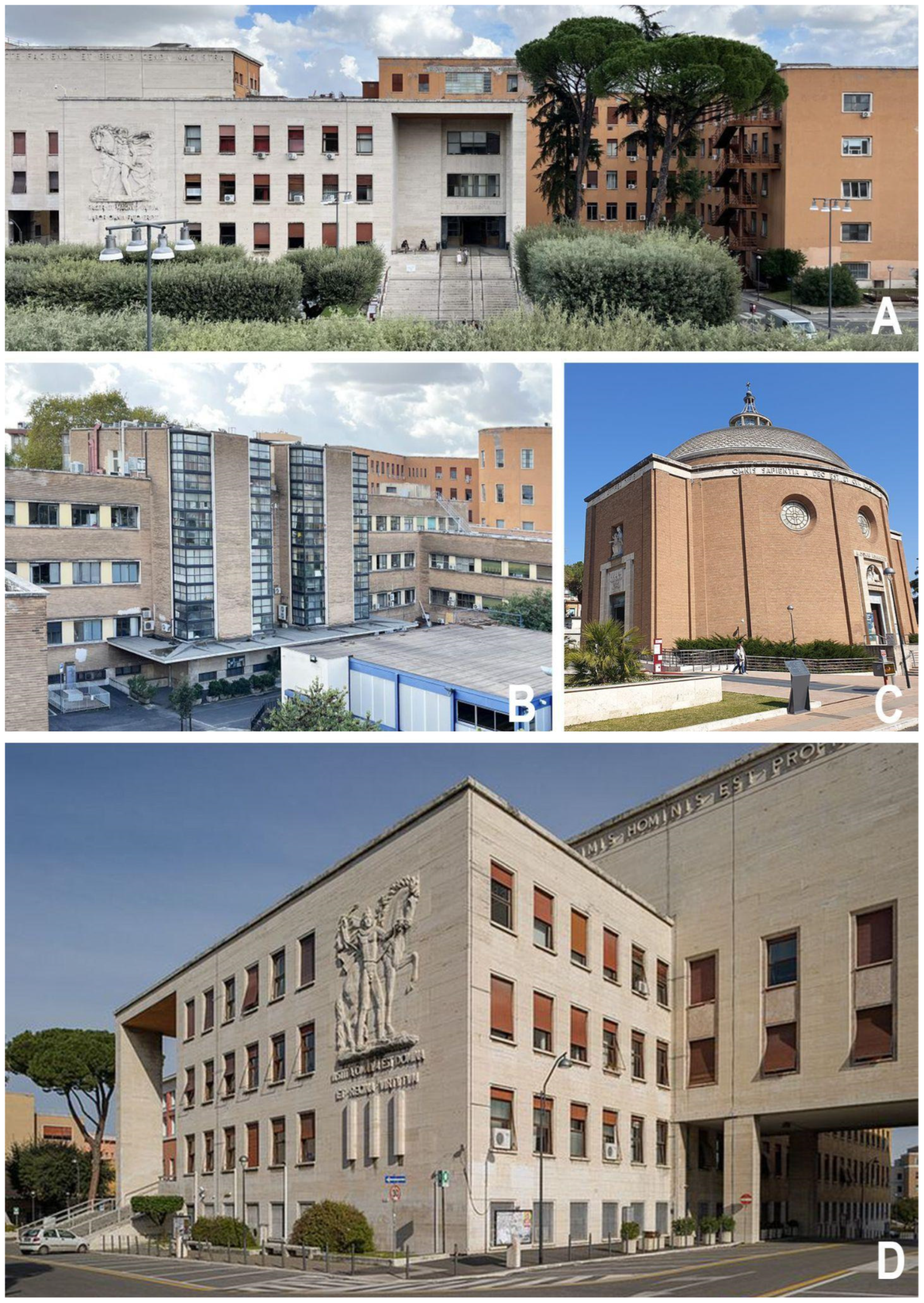
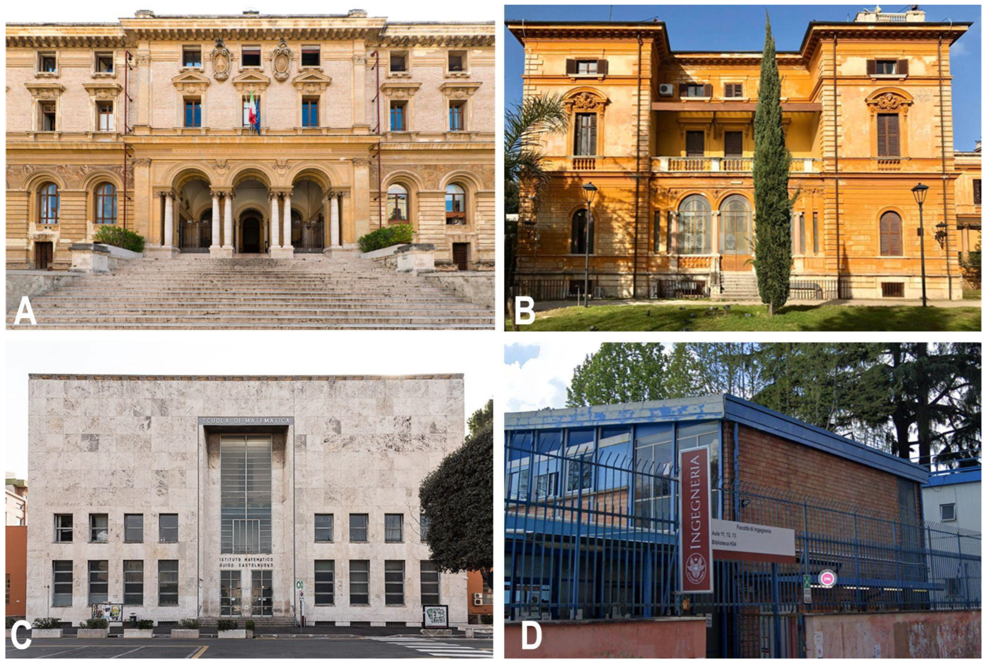
  • Layered historical buildings: monumental buildings of high historical value, characterized by notable technical construction stratification (e.g., the Faculty of Engineering in San Pietro in Vincoli);
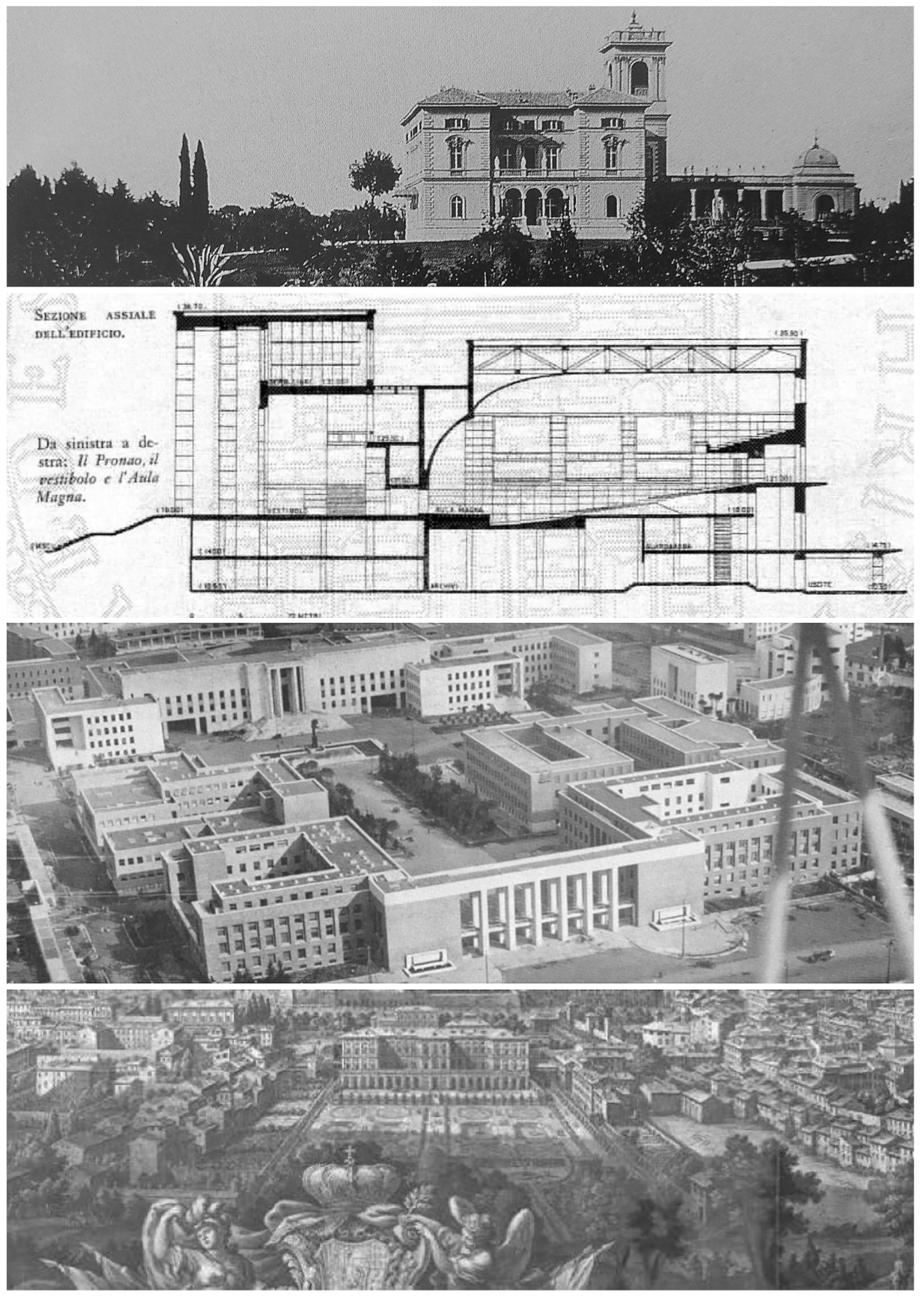
  • Nineteenth-century and early twentieth-century buildings: buildings of architectural value, characterized by substantial technical and construction homogeneity in the walls (e.g., Villa Mirafiori, Faculty of Architecture in Piazza Borghese);
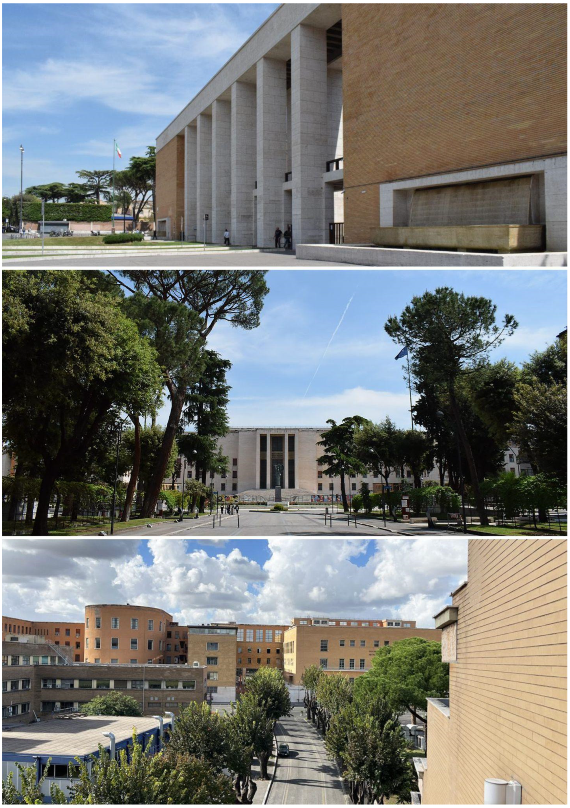
  • Rationalist-style buildings: buildings from the 1920s to the 1950s, characterized by a geometric design approach, innovative technical construction features in mixed reinforced concrete and steel, and highly standardized construction elements (e.g., the buildings of the University City);
  • Existing buildings not belonging to any of the categories identified above: existing industrial or former industrial buildings converted into functional facilities, and/or contemporary buildings without particular architectural or artistic value (e.g., some buildings in the Castro Laurenziano complex);
  • New buildings or new interventions carried out on existing buildings or portions of them.
The purpose of surveying the architectural features and building typologies to which the various buildings can be ascribed is to guide the AGE technical office (see Section 1.3.1) towards a shared, homogeneous, and faster design approach (whether for conservative or extraordinary maintenance). Furthermore, given the necessity of complying with mandatory digital procedures, both for data acquisition and data submission, a subdivision into building categories is a fundamental prerequisite for constructing a uniform basic structure for modeling all buildings within the Sapienza real estate assets (see Section 2.2.2).

2. Materials and Methods

2.1. First Version of the Sapienza Protocol: A Research Tool

2.1.1. The Reasons for the Protocol

The creation of an informed model, particularly HBIM, involves multiple operational practices. The software used, while guiding the process, can sometimes limit the methods of modeling existing structures, interfering with the complex process of building digitization. This digitization, aimed at creating digital copies (often idealized), contains data useful for the purpose for which the model itself was conceived. Each user works according to their own knowledge and skills, both architectural and technical, and can find their own approach to building models that deliver the intended information. While this individualized approach is generally effective across a range of production contexts, it becomes significantly more complex when applied to creating a system comprising numerous models of very different buildings. In such cases, ensuring uniformity in the quality and quantity of information across all models is essential.
Some studies, both in the scientific field and elsewhere (see Section 1), have attempted to create operational standards. This has led the Sapienza University to recognize the need to undertake the ambitious task of creating a comprehensive database of informed models for all its buildings, establishing shared modeling practices.
This led to the development of Protocol v1.0, a document designed to guide all phases of building digitization. The protocol addressed a range of objectives, including the following:
  • Preparation of tenders;
  • Maintenance planning;
  • Knowledge management;
  • Integration and modification of models over time;
  • Archiving strategies.
The document served as a comprehensive guide for leveraging digital modeling as a powerful tool, systematically integrating technical requirements for operational use with cultural considerations. These cultural aspects addressed theoretical and scholarly reflections on the potential of digital models in architectural representation and research. The protocol’s dual focus balanced technical requirements for standardizing software use and model construction with a theoretical framework for utilizing these models. This framework emphasized not only the types and methods of information included but also how digital asset copies could preserve the essence and uniqueness of the original buildings.

2.1.2. From Theory to Practice

Analyzing the state of the art (see Section 1) regarding these specific issues, it immediately became clear that this topic was primarily addressed from the perspective of mere file management, aiming to simplify understanding for users. While this aspect should have been considered by the protocol, it alone would not have sufficed. The mere application of a standard could not adequately capture the true characteristics of buildings without addressing the theoretical and design principles underlying them.
For this reason, the protocol emphasized the application of a multidisciplinary approach. This approach imposed a renewed focus on understanding the object’s history, evolution, and context. It placed the building within a well-defined historical and critical framework.
The goal of this modeling approach, which began with the history of the building, was to encapsulate the intrinsic nature of the object being analyzed within the model. From the outset, this approach was vital in addressing the needs of Sapienza and its building heritage, which is unique on the international stage.
Each intervention represented a challenge—not so much in applying a standardized approach, but in characterizing the specific features of each building which had to be reconstructed within the digital modeler. The real challenge of Protocol v1.0 lay in identifying a strategy to address this specific need: creating a system of rules and methods applicable across all cases using consistent technical parameters while also capable of reflecting the complexity and uniqueness of each building. This was achieved through a rigorous, innovative scientific approach.
Starting from the operational objectives defined by AGE, the research focused on identifying the cultural requirements to be respected when dealing with historical artifacts of recognized architectural value.
Developed over several years of research, the protocol began with a preliminary phase of understanding technical problems, making choices to ensure homogeneity. This homogeneity was necessary to produce a model that would be easily recognizable and readable by both the technicians responsible for modeling and, crucially, future users. The study then focused on defining a common approach that not only emphasized the uniqueness of each building but also ensured that the digital copy maintained continuity with the building itself. This was achieved by integrating the ideal aspects of the design phase (geometry, proportions, cultural considerations) with the changes introduced by time.
Instead of taking the current state of the building as the starting point, the approach used historical studies to understand the evolution of the building over time. This historical perspective played a central role in the subsequent modeling phase. This innovative approach was not anticipated by existing digital modeling systems. However, once its common rules were defined and integrated with technical and operational considerations, it was tested on various buildings within Sapienza’s architectural heritage to validate its operational effectiveness.
Introduced in university courses at different levels, the protocol’s preliminary versions allowed initial comparisons with real-world applications. These experiences helped verify the model’s effectiveness, often leading to structural adjustments to better address needs arising during construction. Such adjustments were especially necessary when dealing with buildings featuring non-standardized morphological characteristics or complex stratigraphies of events that contributed to their recognition as architectural masterpieces today. Given the inherent complexity of historical buildings, this preliminary evaluation phase focused on some of the most challenging and least standardized structures within Sapienza’s heritage: Del Debbio’s Faculty of Valle Giulia, Giò Ponti’s Faculty of Mathematics, and Capponi’s Institute of Botany. These buildings, with their distinctive features, demonstrated the necessity of an approach that transcended the technical construction of a digital model. In many cases, this required overcoming the constraints of modeling software.
Historical buildings required addressing deeper aspects of their design, such as the geometric and proportional principles intrinsic to the original design concept. These elements are often obscured—at best, by cladding and finishes; at worst, by subsequent additions and modifications over time. Including this legacy within the digital twin was essential to creating an accurate representation, as it sometimes resolved operational challenges in the modeling process itself.
Through various phases of analysis and validation—achieved through research and study of these buildings—a quality standard was defined. This standard applied to all models, whether representing new or historical buildings. By overcoming the limitations of machines and software, these tools were reoriented towards enhancing knowledge and valorizing the digital model as the ultimate expression of the building. This approach represents perhaps the most significant innovation introduced by the protocol, which continues to be refined and improved in subsequent versions.

2.2. Second Version of the Sapienza Protocol: An Operative Tool

2.2.1. The Reasons for Drafting a New Protocol

Since 2021, Sapienza’s real estate portfolio has been the focus of a digitalization campaign aimed at meeting the current requirement to adopt BIM processes for all public tenders exceeding EUR 1 million (New Public Procurement Code, D.Lgs 36/2023 [3]). This approach decisively moves beyond the traditional notion of procurement as merely preparing paper documents and completing bureaucratic procedures, enabling all phases of the process to be managed digitally and interoperably on certified platforms. This need marked the starting point of a process spanning from 2021 to 2024, encompassing several key activities: the surveying and modeling of the entire real estate portfolio in accordance with BIM processes; drafting a new version of the protocol to adapt a research-focused document for the effective management of the university’s assets; and, finally, conducting a comprehensive review of the produced models. The surveying and modeling were carried out by external companies, the drafting of the protocol was undertaken by the group authoring this article, and the historical research on the buildings and the review of the surveying and modeling outputs were conducted by the Sapienza University of Rome Department of History, Representation and Restoration of Architecture’s startup with Janus s.r.l.
Within this framework, the first version of the protocol, originally developed as part of academic research to explore how BIM could support the management of the university’s architectural assets, underwent several revisions. It became the reference document for Sapienza as a contracting authority and for companies awarded contracts for building interventions. Protocol v2.0 responded to the practical demands and timelines of professional practice, incorporating significant adaptations. The most notable innovation was the introduction of five building categories to classify properties (see Section 1.3.2). The document covered all relevant aspects for preparing contract documentation, including the following:
  • The modeling framework;
  • The quantity, type, and format of deliverables;
  • Nomenclature standards for 3D and annotation elements;
  • Strategies for modeling 3D components;
  • The definition of LOD (Level of Development),

2.2.2. General Settings and Fundamentals

Sapienza, with the aim of digitizing its real estate assets, prepared a cloud-based IT structure to adhere to criteria required by current legislation in terms of interoperability, collaboration, coordination, and sharing of data between the various actors involved in all phases of the construction life cycle. The CDE [27,28,29,30] is defined as an “Environment for the organized collection and sharing of data relating to digital models and documents, referring to a single work and a single complex of works” [31]. It establishes the roles, rules, and flows necessary for the production, management, and transmission of information and their connection and interactions in digitalized construction processes (see Section 3.4) (Figure 7).
To be correctly interpreted, the shared information must be accessible, unambiguously interpretable, and organized in open formats that allow for seamless digital information exchange, ensuring compliance with legislative requirements and protecting both the general contractor (Sapienza) and the economic operator who won the tender. If necessary, the delivery of the models may include, in addition to the open format, also the related proprietary format that the EO specifies in the offer.
The models, as well as all the basic material and preliminary documentation relating to the current state, are made available to the respective parties within the common data environment provided. These data are appropriately organized by workflow, accessibility, and modification, depending on the roles covered by the various operators involved, and the transparency of the operations is guaranteed, since it is always possible to verify who and when performed the upload.
For buildings and aggregates, Protocol v2.0 establishes that disciplinary models and federated models must be produced in open IFC4 format together with libraries of parametric digital objects organized by discipline, and a table file which explicitly explains in full the nomenclature and codes used (see Section 2.2.4). The protocol identifies three disciplinary models: one civil, one dedicated to plant systems, and one for external spaces (see Section 2.2.3). Specifically, the civil model incorporates both the architectural and structural aspects with appropriate parametric distinctions of discipline. This choice derives from the fact that the investigations conducted did not include invasive and/or destructive analyses that would provide for a complete acquisition of information, also relating to hidden elements or internal infrastructures of the building. The same choice influences the modeling of the systems, limited to the visible components only (see Section 3.3). To each civil model of each building, a specific building category is assigned. The schematization by building categories influences modeling operations and aims to trace a compositional order and architectural/parametric logic that the BIM tools can enhance. For this reason, the protocol establishes that the appropriate templates and settings should be organized beforehand. These digital environments must be implementable over time with information, data, and specificities that allow the setting up of a modeling environment that is representative not of a specific building but of a particular architectural and construction typology.
For example, for those buildings in which a standardization of the construction process is known, such as Rationalist buildings or prefabricated structures, the modeling will necessarily have to make use of regulatory tools and geometric–dimensional constraints, in particular planimetric and altimetric reference elements, choosing those that best interpolate the numerical model resulting from the survey. The position of these references must also be assessed in relation to the preliminary documentation provided (project drawings, previous surveys, technical–constructive reports, etc.) (Figure 8).
For those buildings not having an explicit compositional standardization, such as for stratified historical buildings (category A), the positioning of planimetric and altimetric references might be trickier and must be evaluated based on the interpretation of the survey data. The references must highlight, where possible, alignments and correspondences between the various elements, and in any case, the perimeter limits of the buildings within which the model is developed must be highlighted (Figure 9).
Following this principle, the use of such references becomes mandatory in the case of new construction of entire buildings or even just portions of them.
The templates, continuously refined with each model of the specific characteristics of each category, must be delivered at the end of the assignment. This will enable the contracting authority to provide, for future contracts, not only the preliminary documentation but also pre-configured settings that help guide, streamline, standardize, and accelerate subsequent modeling processes.

2.2.3. Main Differences from Protocol v1.0

The second version of the protocol introduces significant innovation by establishing a framework within the federated model. In addition to the ARC + STR (Architectural + Structural) and MEP (Mechanical, Electrical, and Plumbing) discipline models, the OUT (Outdoor) model has been added, which pertains to the outdoor areas surrounding the buildings. This decision reflects the recognition of Sapienza’s real estate as being organized into complexes composed of multiple buildings within defined perimeters that include roads, sidewalks, vegetation, and urban furniture elements (i.e., the university campus, the complex of Villa Mirafiori, San Pietro in Vincoli, via A. Scarpa, and the Botanical Garden). This approach acknowledges the importance of situating buildings within their surrounding spaces rather than treating them as isolated entities, ensuring they are represented in models consistent with their actual configurations.
The structure of the Protocol v2.0 retains the format of v1.0, dividing it into four sections: two theoretical (Section 1, Premises, and Section 2, Methodological Approach) and two operational sections (Section 3, Guidelines for Modeling, and Section 4, Technical Section). This distinction accommodates the need to address certain aspects before constructing the digital model and others that the model itself reveals (Figure 10). Both parts are essential, as they ensure transparency in the digitization of architectural heritage and certify the model’s validity by integrating information about the building with details of the structural process [32].
Protocol v2.0 focuses on the distinction between the information that must be known before starting the modeling process and the information that can be inferred from the model.
The first type of information includes the building’s structural framework, object geometry, spatial layouts, and data derived from survey operations. In the context of historical–architectural heritage, such information is inherently partial and must be supplemented with insights from historical and archival research. Archival research addresses elements that cannot be directly observed, such as the design intentions, various historical phases, and construction techniques. This approach underscores two critical factors: the disparity between the extended timelines required for academic research and Sapienza’s need to obtain models within strict deadlines (3 years); and the opportunity to compare the constructed structure with its original design—where available—by referencing planimetric elements. Specifically, Protocol v2.0 applies this approach to buildings classified under categories B and C, for which a standardization of the construction process is acknowledged. This process also highlights the variability in the quantity and type of information associated with model elements, necessitating a pre-defined LOD (Level of Development) for each element. In this respect, the second version of the protocol integrates data from both direct and indirect investigations, identifying elements with particularly significant or complete data from an architectural heritage perspective and assigning them a higher LOD than the average for other model elements. This detailed treatment applies not only to systems components but also to sculptural and decorative elements and furniture. Sapienza, as the contracting authority, established with the modeling companies the LODs that the models and their elements were required to meet—LOD B (generic object), LOD C (defined object), and LOD D (detailed object)—in accordance with the Italian standard UNI 11337-4:2017 [31].
The insights gained through modeling, following data analysis and shape construction, include all information derivable from the model itself. A key factor is the evaluation of reliability, which primarily hinges on the consistency of survey data. If survey data are incomplete, they compromise the model’s accuracy, as a digital replica of a building must be comprehensive. Protocol v2.0 addresses this by introducing parameters to identify and characterize unsurveyed elements. Such elements can either include documentation supporting the modeled object’s creation or explicitly indicate the information source. This emphasis on accuracy and completeness has influenced how digital objects are conceived, promoting a standardized approach to digital objects. For example, in stratigraphic objects (e.g., walls and floors), Protocol v2.0 recommends a formal approach, modifying objects directly within the template, and an operational approach, separating finishing layers from structural layers to facilitate maintenance operations. Regarding loadable families, Protocol v2.0 introduces an initial distinction between 3D and 2D objects, further subdivided by discipline, category, and family. Types are defined directly within the digital project environment, establishing dimensional variations. The second version of the protocol also specifies deliverables provided to Sapienza by companies tasked with modeling. It defines data exchange methods, promoting the use of both open and proprietary formats. The deliverables include the following: the federated model, comprising the ARC, MEP, and OUT disciplines; a library of digital objects used in the modeling, categorized by discipline; a file detailing the nomenclature used; and the geometric interference report.

2.2.4. Protocol v2.0: Continuous Iterative Tool, Control, and Verification

The protocol’s operational workflow relies on a first step of building analysis for architectural element breakdown and their recomposition through informative parametric modeling. The process of building models is based on the processing of data acquired preliminarily and, above all, their critical interpretation.
In terms of metric and geometric accuracy, the reliability of the various interpretative models must be verified when comparing them with the survey data. The recognition of the geometric–compositional matrix of a building constitutes a subjective interpretation and is a result of the discretization of the components of the building. Deviations between the survey data and the alignments identified for modeling using planimetric and altimetric references are evaluated with respect to the accuracy of the numerical model (2–3 cm, see Section 3.2): if the deviation is lower than the accuracy level, the alignments must prevail, while, if it is bigger instead, the model must interpolate the trend defined by the point cloud as much as possible. A second parameter to be evaluated is related to the level of development and the level of information needed. The latter confirms the importance of enriching the model with information content while inserting only the information really needed, to streamline the process and construction times and optimize future management. During the modeling process, geometric and metric reliability must be constantly verified and, once the models are completed, officially certified through a report on the results obtained from automatic clash detection algorithmic operations, as required by the UNI 11337 standard, part 5, Information flows in digitized processes [31]. Geometric interferences between digital objects should be individually checked within each discipline and through interdisciplinary clash detection in the federated model (Figure 11).
Sapienza has evaluated the modeling strategies outlined in the protocol from a purely technical perspective, admitting minimal interferences which do not impact the model’s quality, either in terms of reliability or computational calculations. Based on this assessment, Sapienza acknowledges specific tolerance thresholds depending on the type of digital object and whether the interferences are localized or widespread.
During the delivery phase, the interference report must include a detailed justification if the economic operator is unable to resolve any declared interference exceeding the tolerance limits set in the protocol. Alternatively, it must confirm the resolution of such interferences following verification and reporting by Sapienza.
In terms of semantic accuracy, the digital object must be created consistently with the function performed by the real element, taking into account the construction typology in which it is used and the structural and formal relationships that it establishes with the elements closest to it. In those cases where this is not possible due to a lack of direct correspondence between the digital object and the real object, the modeling solutions are assessed punctually by the contracting authority and the economic operator during the information management plan. Precisely because of variable strategies in the modeling of more or less univocally defined components, the use of an agile and intuitive nomenclature takes on particular importance, capable of explaining the function of the various elements and extracting QTO (Quantitative Take Off) and MTO (Material Take Off) abacus for computational purposes. Among the files expected for the final delivery, the extended file of the nomenclature of the digital objects used is mandatory, organized in tabular form according to discipline, technical element code, function code covered, any variants, and/or notes referring to each object or class of objects (Figure 12).
The conventions for the naming of digital objects established by the protocol follow the following criteria:
  • Clarity: Ambiguity in the definition of the denomination is unacceptable;
  • Completeness: On the basis of a specific typology of digital object, the criterion adopted for its denomination must be applied in its entirety to all other objects belonging to the same typology;
  • Flexibility: The naming criterion must be able to be used, with few modifications and rare exceptions, for various elements belonging to multiple disciplines of the same project and to multiple projects;
  • Internationality: The denomination, codes, and abbreviations used must be related to the English language (as well as the software designated for modeling), using, however, library objects which refer to standard values consistent with the Italian national building regulations.
The creation of the various models, representing the actual state of real buildings in the digital environment, must be able to allow the management of future actual states and keep track of the interventions that the building faces over time. The temporal phases of intervention therefore become a fundamental tool for the correct representation and management of the heritage by AGE. Since, in most cases, these are existing buildings, the template requires that the models built as a restitution of the current state must be traceable to an “existing” time phase that is identified as the princeps moment for the flow of virtual design time; all interventions planned in the future must be gradually associated with construction phases in orderly succession and allow comparative visualizations of demolition and construction between two consecutive phases. In this sense, Protocol v2.0 is configured in terms of implementation as a control and management tool in a continuous iterative process, making use of the multidimensional tool aimed at controlling next-level planning which must consider the entire life cycle of the building.
Once modeling has been completed, the overall setting of the parametric digital environment and the coherence between geometric, semantic, and information aspects must be assessed overall through different levels of verification, by different actors, in relation to the specific requirements requested by Sapienza (see Section 3.4). The certification of the reliability and validity of BIM allows for the extraction of alphanumeric data and graphical drawings that can be used as a basis for tenders for subsequent procedures. With this, the task of the protocol is exhausted, which plays the dual role of guideline throughout the process of model construction and control, verification, and validation tool for what is produced.

3. Results: Workflow for the Final Version of the Sapienza Protocol

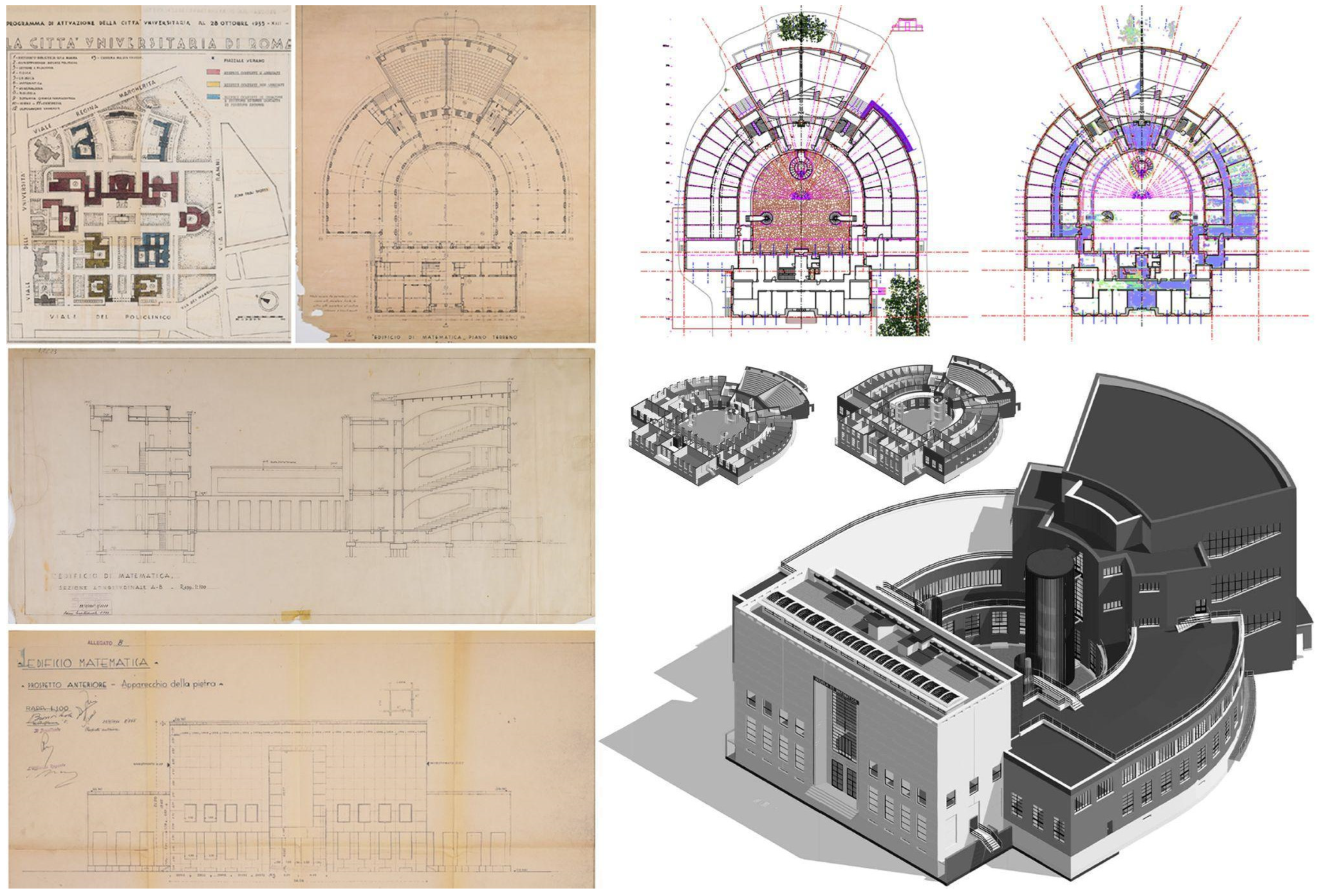
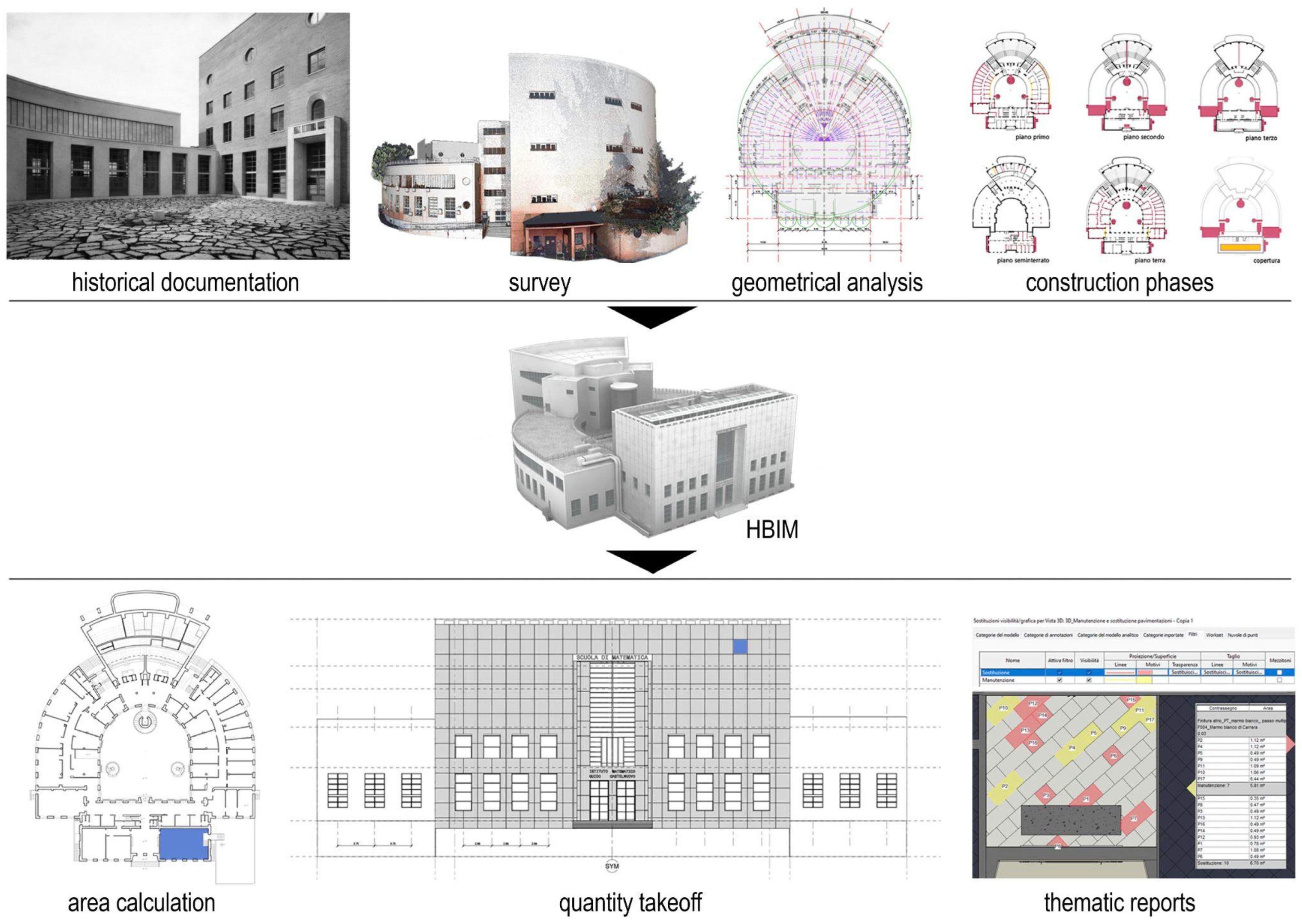
3.1. The Historical Research Process and the Identification of Featured Elements

Starting from 2022, after Protocol V 2.0’s release, the digitization process started, and the research group identified the workflow to be assessed by contractors based on the following phases:
  • Preliminary historical research;
  • Identification and cataloging of high-quality architectural elements;
  • Data capture and point cloud processing;
  • BIM.
This paragraph outlines the methodologies and procedures used to plan phases 1 and 2, as well as to standardize and evaluate the results.
The first two stages were designed with a specific goal, the digitization process was not merely seen as a tool for building management but as an important opportunity to widely apply the methodological approach developed by the research group in an extensive way on a larger number of case studies to evaluate bottlenecks and challenges. The research methodology and applications on specific case studies are explained in several contributions authored by the research group [16,33,34,35,36].
Preliminary historical research was essential for contextualizing each building in its construction period and location by gathering all available bibliographic sources, including project drawings and iconographic references. At the end of this phase, a report was delivered summarizing key findings and listing all relevant sources. This research allowed for a deeper understanding of each building, emphasizing key architectural transformations that, in many cases, significantly influenced the buildings’ current functions.
For complex and stratified constructions, understanding the various building phases and transformations allowed the design of a more coherent BIM structure in terms of defining building units and their interrelations. For the university campus, instead, the research focused on collecting original design drawings to document recent transformations and identify fundamental axes, alignments, and proportions to then be used in the modeling phase. Additionally, the historical research proved to be a first reference for identifying distinctive architectural elements to be included in the phase 2 catalog. This documentation was also structured for future integration into each building’s digital asset inventory to support further investigations (Figure 13).
Following the completion of phase 1, phase 2 focused on identifying and mapping architectural solutions considered highly significant for each structure. This list was compiled by integrating data from the phase 1 report with findings from on-site inspections. Each identified element was cataloged with a unique ID code, photograph, and plan location. This catalog served as a reference for survey contractors to guide data capture operations and ensure an appropriate level of detail for these elements.
For the BIM phase, instance parameters were created to properly filter distinctive elements, and to each one, the corresponding ID code was assigned. In addition, the catalog reported for each distinct element some prescriptions in terms of the level of geometry to be reached in BIM considering the morphological complexity of the element and its historical and architectural relevance [40]. Following this approach, for university campus buildings, all the architectural solutions that were specifically designed as standardized elements were identified. For example, the sash windows and their travertine frames, the façade covering travertine slabs with their modules and their interesting installation solution, and the stair railings are highly representative of a modernist conception of architecture and are a tangible result of the coordinated design process employed for the campus. For those buildings which were classified as A or B category, most of the featured elements were related to the historical or archeological components that were evaluated as distinctive to describe the architectural identity of the building. In this case, for example, monumental staircases, architectural order components, windows, and door frames, as well as sculptures and erratic elements, were classified and included in the catalog (Figure 14).
At the end of these two phases, survey contractors were asked to plan their following activities on the basis of this wide documentation provided.

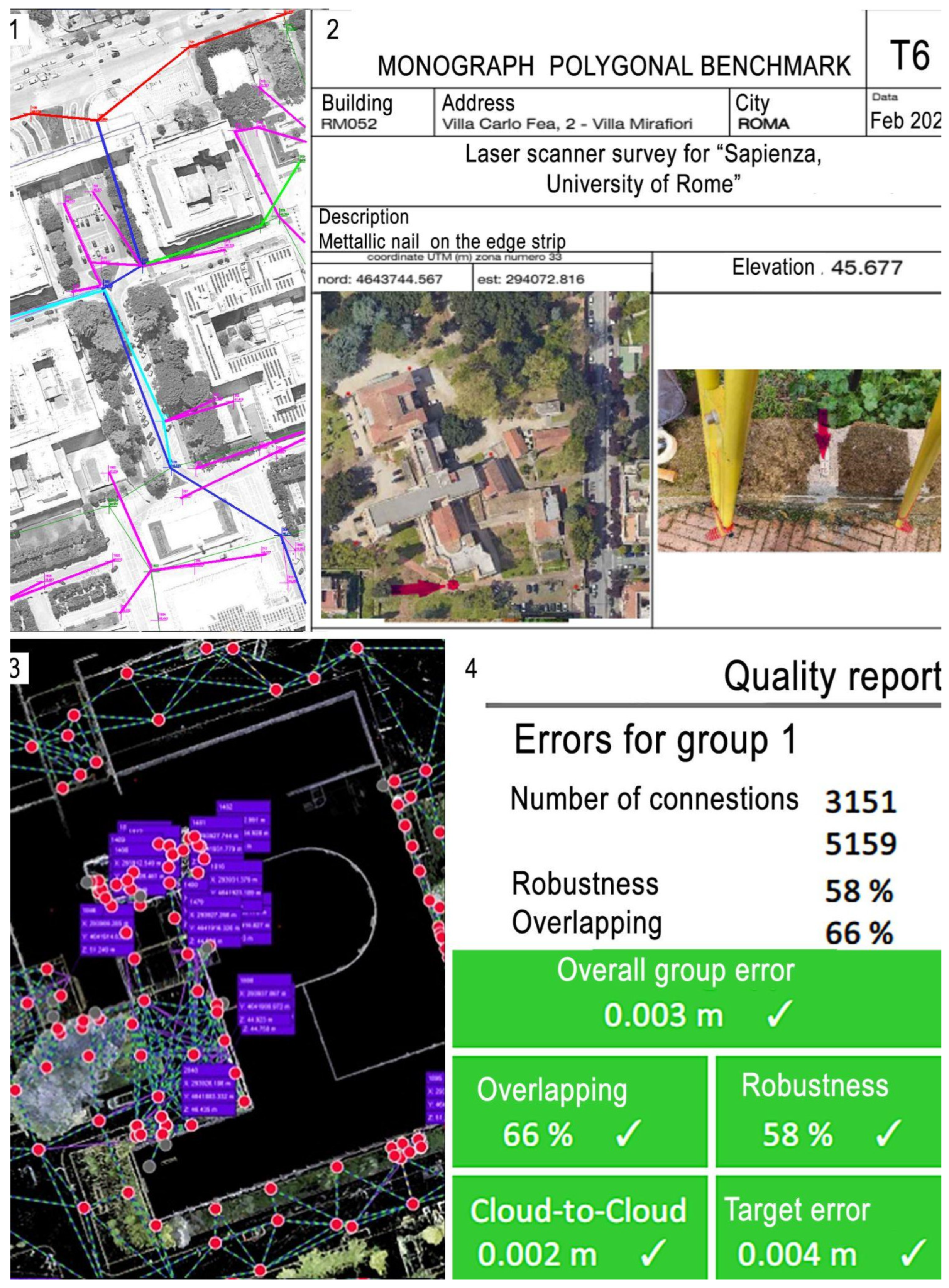
3.2. Architectural Survey and Evaluation Process
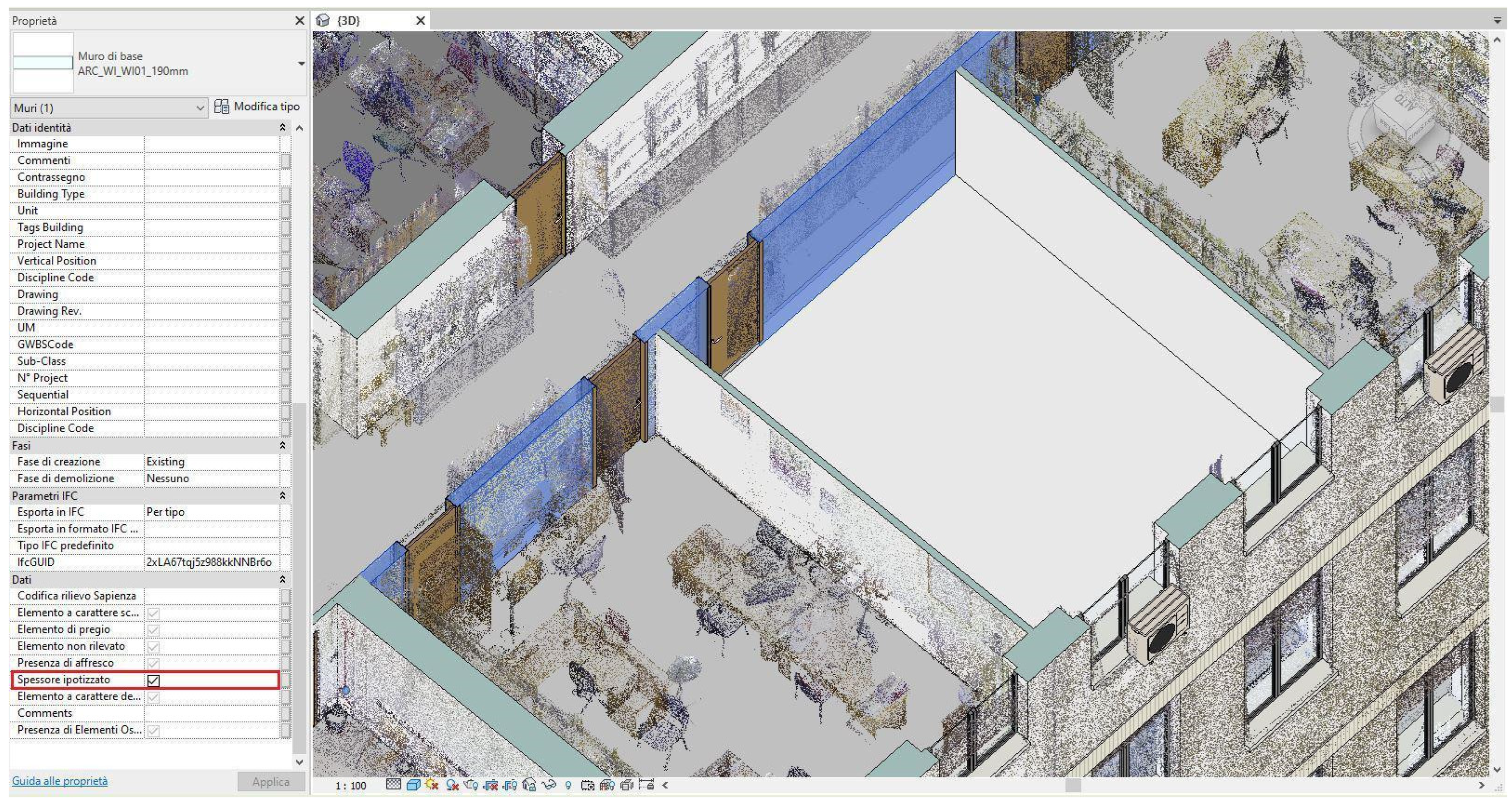
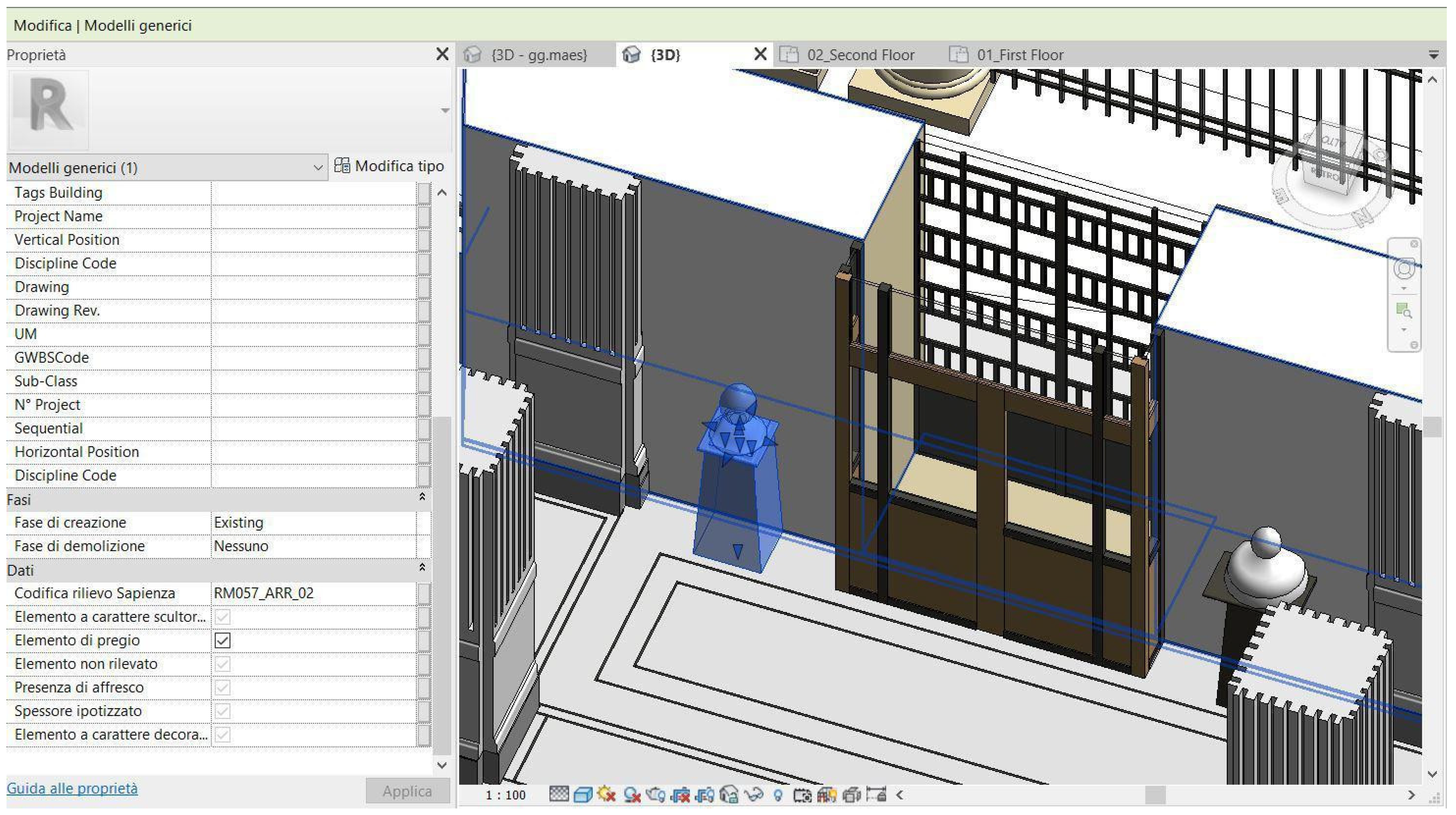
Phase 3 of the digitization process (see Section 3.1) focused on 3D recording. Given the exceptional number of buildings to be surveyed, it was necessary to establish guidelines to ensure a standardized approach. To address this, the research group developed specific requirements for data capture, principles for data integration, and quality criteria for the final evaluation of point clouds.
For the data capture process, the requirements primarily addressed the technical and technological methods to be employed. Static 3D laser scanning, UAV photogrammetry, topographic surveying, and geolocation were mandatory techniques. However, questions arose regarding the acceptance of SLAM-based systems for geometrically simple secondary spaces. While these systems aligned with the overall project objectives, their generally lower image resolution and characteristic point cloud structure posed potential challenges. Specifically, they risked compromising the interpretation of architectural and system components during the modeling phase. Consequently, SLAM-based systems were excluded from the process.
The guidelines also established standards for each capturing technique, specifying criteria for point cloud resolution, overlapping, and texturing.
Beyond the technological requirements, contractors were asked to deliver beforehand a Gantt chart for all the survey operations on the entire building’s assets, a survey project for each building or building complex, and the list of capturing devices to be adopted. The survey project had to be informed by historical research and cataloged features. It was then assessed to ensure coherence with the specific characteristics of each building, considering accessibility constraints and the alignment of capturing strategies with the cataloged distinctive elements.
Concerning data integration, the guidelines outlined the role of each survey methodology to be adopted. GNSS surveying was required to geolocate each building and was conducted in conjunction with topographic surveying to ensure metric accuracy. The topographic survey established a robust network of stations and reference points, designed to support future integrations. Three-dimensional laser scanning was required to survey all the accessible interior and exterior spaces, providing detailed information about building geometric features.
The point clouds were geolocated using GNSS reference point coordinates, while their overall metric and geometric accuracy was further verified against topographic points. For building complexes, such as the university campus, a topographic net and laser scanning operations were adopted also for the connection spaces. Finally, UAV photogrammetry was used for roof capturing, and the derived point clouds were then aligned based on topographic data.
As a result, for each building an integrated point cloud was elaborated and delivered in a double version. The first one preserved the full resolution as well as the scanning location metadata it needed to be archived as raw data. The second one, instead, was the result of a 1 × 1 cm decimation and was further used as a base for BIM.
Together with point clouds, contractors were asked to deliver a laser scanner point cloud alignment report, a report to highlight the eventual differences between the survey project and the performed one, and a control point datasheet, containing information related to localization with respect to the building, the absolute coordinates, and a picture of point materialization (Figure 15).
All the products were then evaluated according to specific criteria identified by the research group. When dealing with point cloud evaluation, it is immediate to refer to quantitative parameters able to describe in an accurate way their main characteristics [41]. Such parameters can be, for example, the cloud average overlapping, the cloud average resolution, the number of scans per a certain surface unit, the number of pictures for photogrammetry, the 360° image number of pixels, etc. On the one hand, these parameters provide the possibility to compare in a quick and accurate way different point clouds and provide quantitative standards. On the other hand, instead, they are not sufficient to truly understand if a point cloud is able to provide enough information to support a certain interpretation of a building. Considering the entire Sapienza digitization effort, it was necessary to go beyond the mere quantitative parameters to insert qualitative ones to provide an overall evaluation using a critical approach. In this sense, for example, it was crucial to evaluate if the 360° images captured by the scanner allowed wall material and construction technique recognition, if the completeness of point clouds was sufficient to identify and reconstruct all the walls’ positions, or if the featured elements were captured in an adequate way. Both quantitative and qualitative parameters were used to evaluate each building point cloud and release a final report.
The report was designed to summarize and evaluate the entire survey process, from the initial project planning to the analysis of the various deliverables. Based on their criteria, point clouds could be fully approved, conditionally approved with required integrations, or rejected.
For fully approved point clouds, all deliverables were archived, and the BIM process could proceed. For conditionally approved point clouds, contractors were required to provide integrations within a certain time frame before moving to the BIM, while for rejected ones, a new revised version of all the deliverables was requested. From 2021 to 2023, more than 150 buildings were surveyed according to the presented workflow (Figure 16).

3.3. BIM

The final step of the workflow (phase 4) focuses on creating informative models that serve as digital inventories for the assets belonging to Sapienza’s heritage. This task is far from trivial, because it needs not only the knowledge of architectural shape but also of the technological systems and structural principles underlying the construction of each building.
The quality and transparency of the entire HBIM process hinge critically on the accurate definition, setup, and production of the digital information model. This effectively shifts the emphasis of the entire operation from the model itself to the act of modeling [37]. The modeling process represents the pivotal moment where the theoretical guidelines and operational procedures outlined in the protocol are put into practice.
Due to the centrality of the modeling process, significant discrepancies emerged during the operational activities between the methodologies adopted by the contractors and the control implemented by the research group. In this context, the second version of the protocol was revised and, in some cases, redefined to align with the new needs that emerged during the modeling phases.
The final version of the protocol comprises the following documents:
  • The main document describing the methodological approach underlying the modeling procedures and the general setup of the models;
  • Attachment A, containing technical guidelines for ARC + STR and OUT modeling;
  • Attachment B, containing technical guidelines for MEP modeling;
  • Attachment C, containing the table of geometric tolerances allowed for digital objects.
The last version of the protocol kept the model structure of the second version in the distinction between federated models of the disciplinary models ARC + STR, MEP, and OUT, but introduced the federated model of building complexes. This model included all sub-disciplinary models and added the model of common outdoor spaces (Figure 17).
When dealing with building complexes, all federated models share the coordinate system, defined based on survey data.
The reliability of the process and the model can be summarized in two fundamental components: geometric reliability and semantic reliability.
In the context of geometric reliability, the approach to source data has evolved throughout the modeling process. Initially, there was a tendency to strive for extreme adherence between the numerical model and the BIM model. However, the subsequent modeling phase prioritized a balanced approach between metric rigor and critical interpretation of the surveyed data (see Section 2.2.4). Furthermore, missing data did not lead to omission but were addressed through interpretive modeling. Indirect evidence, such as historical documents, informed inferred details. To ensure transparency, traceability mechanisms were implemented, allowing the identification of hypothesized elements via an on/off instance parameter (Figure 18).
The modeling process also considered semantic accuracy. The possibility of using pre-defined object libraries, modifying them, or creating new ones using so-called “in-place” methods and/or case-specific methods was progressively verified. This approach also considered the coherence between construction categories and corresponding technological classes. For example, the modeling of a molded window frame (Figure 19) was attributed to the category of masonry components, considering the entire facade system as a single entity. This choice facilitated the computation of interventions consistently with the building categories. Furthermore, this solution was not always applicable in all cases analyzed; therefore, for the correct identification and quantification of elements, a multi-category table was created that based the identification of elements on their specific nomenclature. This table, based on the nomenclature and established preliminarily with respect to the modeling operations, facilitates estimation and quantification operations.
This was applied to sculptural or decorative elements: within the properties of these digital objects, represented only by a simplified geometry, an on/off parameter was introduced for each element (Figure 20). This type of parameter was also supplemented by manual-entry elements and links to other elements contained in the CDE or part of archives and codes already in use by Sapienza.
A total of 120 BIM models were developed following these guidelines, providing benefits to both the professional and scientific communities. For professionals, these guidelines promote transparency and high-quality model creation, while for researchers, they stimulate new research closely linked to the operational practices of the construction sector. The substantial variety of problems addressed has led to the effective drafting of a protocol shared by all stakeholders, combining the needs of the contracting authority, the professional prerogatives of modelers, and the methodological rigor of research.

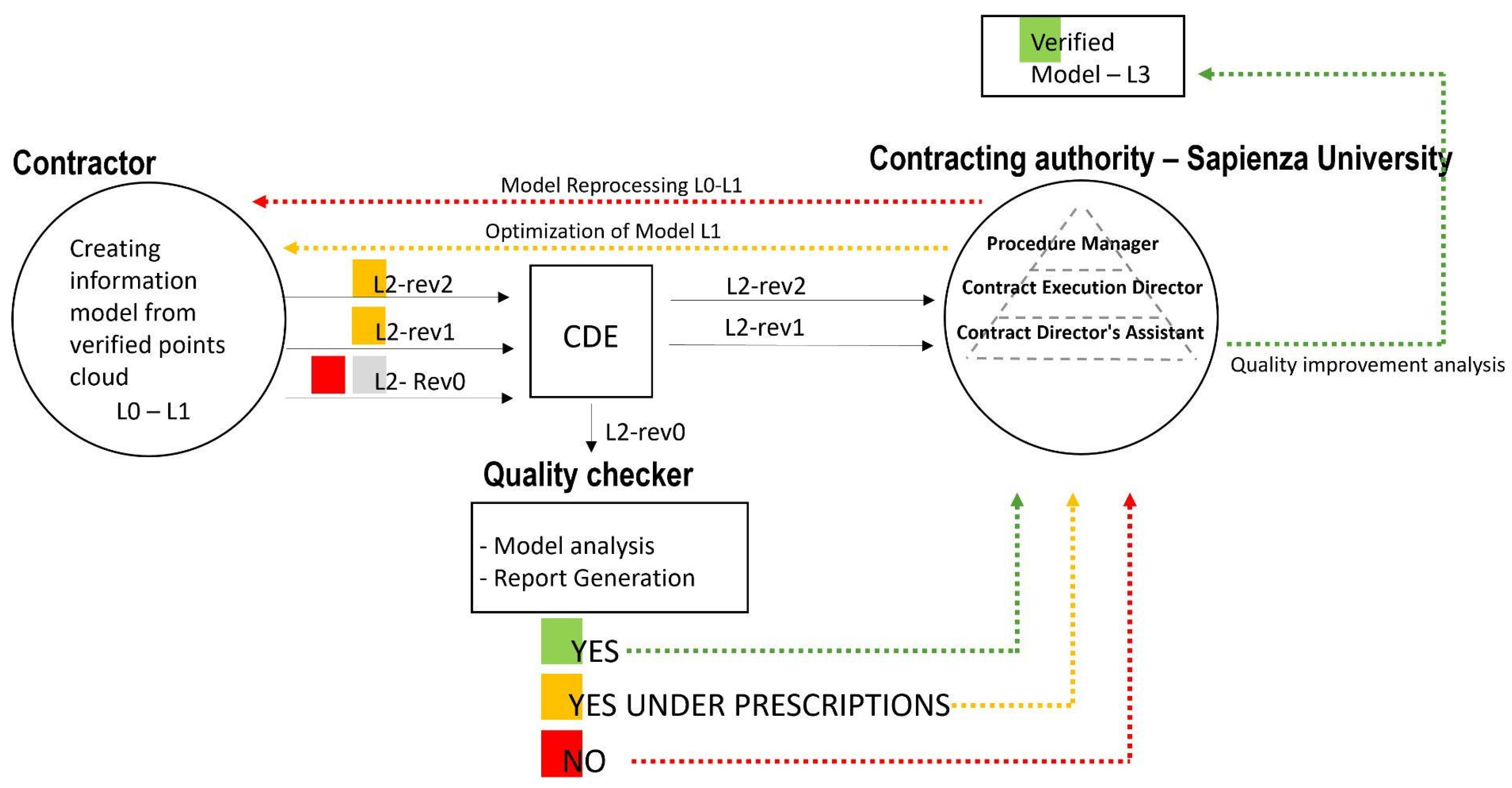
3.4. BIM Evaluation Process

Effective implementation of a BIM process within a built asset management project requires a meticulous definition of responsibilities and information flows. To this end, the establishment of an organizational structure involving both the client and the service provider is necessary, also providing an independent control body responsible for ensuring the quality and consistency of processes.
In addition to defining the roles and responsibilities of each involved part, this organizational structure promotes the adoption of a collaborative paradigm based on the sharing of digital information.
In this regard, the UNI 11337 standard, part 4, provides a useful framework for defining BIM workflows, identifying a series of working and approval states for digital models (Figure 21).
While the working state defines the operational progression of the model and its information content, the approval state defines the level of formal reliability of the geometries and information. The levels of development are as follows: At L0, the model is in an initial development phase, limited to the design team. The information contained is still partial and subject to frequent changes. At L1, the model is shared among the various disciplines involved in the project, but the information content may vary according to the specific needs of each discipline. At this stage, the model is still subject to significant evolution. At L2, the model reaches a level of detail such that it can be considered final and published. The information contained is complete and consistent, and the model is ready to move to the approval phases. At L3, the model is final, verified, and archived. Each level of model development involves specific coordination activities among BIM specialists, the BIM coordinator, and the BIM manager, categorized into three levels:
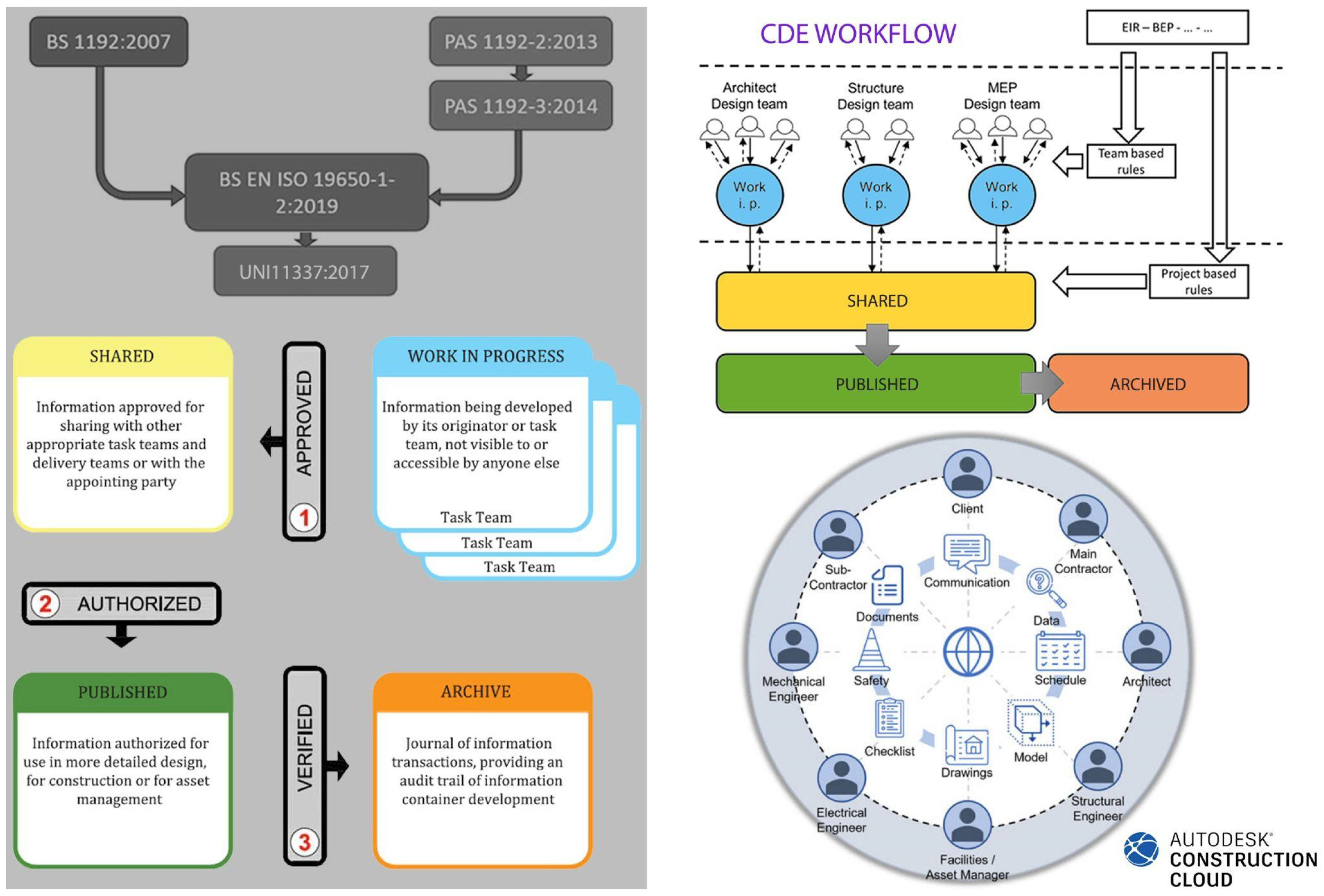
  • LC1: Ensures internal consistency within a single disciplinary model during phase L0, managed by the head of the disciplinary model;
  • LC2: Ensures consistency between multiple models from different disciplines during phase L1;
  • LC3: Involves the BIM manager in aligning BIM models with external data sources such as surveys or traditional documents.
Once internal coordination within the contractor party is complete, the model is published (phase L2) and shared with the contracting authority (Sapienza). A validation process is implemented to assess model quality and compliance with Sapienza’s requirements, ensuring the reliability of the extracted documents. The verification levels include the following:
  • LV1—formal internal verification—checks geometric accuracy, associated information, and representation standards;
  • LV2—substantive internal verification—ensures consistency across disciplinary models, compliance with standards, and correct data extraction;
  • LV3—formal and substantive external verification—validates the completeness, accuracy, and compliance of models and deliverables within the common data environment (CDE).
The first level of verification is ensured by a disciplinary coordinator, while the second is ensured by a supervisor of interdisciplinary information processes (both internal to the contractor). Following the first two phases of verification, an interference report and a descriptive report are produced, which explicitly explain the procedures for identifying and resolving any identified interferences.
The third level of verification, on the other hand, is subject to a control process carried out by an external quality checker (Figure 22).
When the model is published (phase L2), the first procedure, that of rev.0 (L2-rev.0), involves a check carried out by the quality checker with the aim of analyzing the model and verifying its consistency with what is established by the protocol. This verification considers the model setup, modeling prerequisites, model structure, modeling strategies, and management of the information component.
Sapienza (the contracting authority) then provides the contractor with a report compiled by the quality checker including the criteria used for the evaluation, with any notes. The possible outcomes are as follows:
  • Verification passed;
  • Verification passed under prescriptions;
  • Verification failed.
If the verification is passed successfully, the model is acquired by Sapienza as a verified model and moves to the L3 state (archived).
Conversely, if the verification fails, the model is returned to the contractor in the L0-L1 phase, who then carries out a complete revision of the model. Subsequently, the modeler publishes a new version in rev.0 (L2-rev.0) and submits the model to the quality checker, who restarts the verification process.
If the verification is passed under prescriptions, the model returns to the L1 phase to the contractor who, through an improvement analysis related to what was reported, makes the necessary changes and submits it to the quality checker during a second phase, that of rev.1 (L2-rev.1). Subsequently to this phase, if the verification is passed successfully, the model is archived as verified (L3), while if the verification is still passed under prescriptions, the model follows the approval procedure under prescription again, whereby the modeler, who has made the necessary changes, submits the model during a third phase, that of rev.2 (L2-rev.2), to proceed again with the evaluation cycle.

4. Conclusions

After detailing the Sapienza Protocol, it is clear that the university’s efforts have created an effective tool to manage its diverse building stock.
The integration of digital tools like HBIM (Historic Building Information Modelling) in the AEC sector is transformative for preserving architectural heritage. However, to fully unlock HBIM’s potential, addressing data storage and interoperability remains essential, especially for managing complex historic building datasets.
One area for further exploration is developing robust, scalable data storage solutions tailored to HBIM. Historic buildings often require the storage of large volumes of diverse data, ranging from geometric details and material specifications to cultural and historical metadata. Research could focus on creating cloud-based and decentralized storage architectures to accommodate this complexity while ensuring data integrity, security, and accessibility over time.
Interoperability poses another critical challenge, as HBIM’s multidisciplinary nature demands seamless integration across diverse software platforms and stakeholder workflows. Future research could create open-source interoperability standards that facilitate communication between HBIM, GIS, and heritage conservation tools. Additionally, leveraging semantic web technologies and advanced metadata frameworks could enable smarter data sharing.
Artificial intelligence (AI) and machine learning (ML) could enhance HBIM by automating processes like digital surveying, metadata tagging, and predictive maintenance planning. AI-driven methods could also address interoperability gaps by integrating data from different sources. Furthermore, future studies should examine the scalability of HBIM in public portfolios, like Sapienza University’s, across other contexts. Comparative analysis of digitization methodologies could provide valuable insights into best practices and optimization strategies.
Beyond technical aspects, the Sapienza Protocol bridges the gap between theoretical research and the practical needs of the AGE. This collaboration between academia and administration has been key to its success, overcoming entrenched assumptions and balancing real-world constraints with scientific rigor. The protocol has been adopted within university procurement procedures in compliance with current regulations, making Sapienza a leader in digitalization efforts in the public sector. Despite this success, challenges remain. First, data storage presents both quantitative and qualitative challenges. Estimating 2 TB per building for around 100 buildings, Sapienza needs significant medium-term storage capacity. This highlights the necessity of a digital infrastructure capable of storing, editing, searching, and updating content.
This observation, combined with the Strategia Cloud Italia under the Cloud-First policy—a key pillar of public administration digitization in the PNRR—suggests that such infrastructure must be cloud-based. Sapienza recognized this need early and initiated a comprehensive design phase.
Another issue concerns tools for interacting with data. Current applications offer limited, often unfriendly interfaces, while data exploration tools rarely go beyond text-based searches. Instead, access through visualization and direct interaction with 3D HBIMs should be prioritized, leveraging gaming industry approaches. This presents a challenge for phase two of our project, likely requiring a new interface, yet software providers remain reluctant to invest in this area.
Moreover, administrative staff must be prepared to use new tools, requiring revised procedures and training. Public administrations often lag in adapting to regulatory changes. Even at Sapienza, advancing phase two requires a capacity-building initiative to train officials who can, in turn, train others.
The Sapienza HBIM Protocol is a key step in modernizing university asset management, yet much essential work still lies ahead.

Author Contributions

This research is a joint effort by the authors. The paragraphs were written by the following authors: L.P. (1.1); M.A. (1.3.1, 2.2.1, and 2.2.3); M.L.R. (1.3.2, 2.2.2, and 2.2.4); L.J.S. (2.1.1 and 2.1.2); M.G. (1.2., 3.1, and 3.2); A.C. (3.3 and 3.4); and C.B. (4). All authors have read and agreed to the published version of the manuscript.

Funding

This research received no external funding.

Data Availability Statement

Data are available upon reasonable request from the corresponding author.

Acknowledgments

The authors thank Simone Lucchetti (Janus s.r.l.) for conducting the historical research for each building, Antonio Mirandola (Janus s.r.l.) for compiling the catalogs and evaluating point clouds of each building, and Giulia Catalani (Janus s.r.l.) for evaluating the point cloud data for each building. The authors express their gratitude to the Department of Civil, Constructional and Environmental Engineering at the Sapienza University of Rome for their collaboration in drafting “Annex B” of the protocol, alongside Enrico Bentivoglio as the director of the Area Gestione Edilizia of Sapienza and Armando Viscardi and Roberto Giuliani from the Sapienza Technical Office.

Conflicts of Interest

The authors declare no conflicts of interest.

References

  1. Centro Studi Argenta SOA. Report 2023 Il Settore Delle Costruzioni tra Pnrr, Bonus Fiscali, Tassi D’interesse, Capitale Umano e Sfide ESG; National Report by Certification Authority Company; Centro Studi Argenta SOA: Rome, Italy, 2023. [Google Scholar]
  2. Del Giudice, A.; Gallucci, C.; Santulli, R. I Rating ESG: Un Confronto Internazionale; Università Cattolica Sacro Cuore Press: Milan, Italy, 2024. [Google Scholar]
  3. Legislative Decree 32/03/2023 n. 36 “Codice dei Contratti Pubblici in Attuazione Dell’articolo 1 Della Legge 21 Giugno 2022, n. 78, Recante Delega al Governo in Materia di Contratti Pubblici”. Available online: https://www.bosettiegatti.eu/info/norme/statali/2023_0036.htm (accessed on 20 March 2025).
  4. Albino, V.; Ferrara, A. La Gestione Informativa Degli Appalti BIM; Dario Flaccovio Editore: Milan, Italy, 2022. [Google Scholar]
  5. Race, S. BIM Demystified, 2nd ed.; RIBA Publishing: London, UK, 2014. [Google Scholar]
  6. Paris, L.; Rossi, M.L. Data sharing & interoperability. A teaching method. In Proceedings of the Workshop 3Dmodeling & BIM New Evolutions, Rome, Italy, 11–12 April 2024. [Google Scholar]
  7. Singapore BIM Guide Version 2.0. Available online: https://www.corenet.gov.sg/media/586132/Singapore-BIM-Guide_V2.pdf (accessed on 14 March 2025).
  8. Engineering Operations BIM Guidelines. Available online: https://aemdev.panynj.gov/port-authority/en/index.html (accessed on 20 March 2025).
  9. The VA BIM Guide. Available online: https://www.cfm.va.gov/til/bim/BIM-Manual.pdf (accessed on 14 March 2025).
  10. Tang, J.; Li, X.; Qu, W. Blockchain and Digital Transformation of University Asset Management. Open J. Appl. Sci. 2024, 14, 85–100. [Google Scholar] [CrossRef]
  11. Pavón, R.M.; Arcos, A.; Alberti, M. BIM-Based Educational and Facility Management of Large University Venues. Appl. Sci. 2020, 10, 7976. [Google Scholar] [CrossRef]
  12. Brusaporci, S.; Maiezza, P.; Tata, A.; Floris, G.; Vespasiano, L. Il Building Information Modeling per la documentazione e gestione del patrimonio costruito: Il caso studio del polo universitario di Coppito/Building Information Modeling for the documentation and management of the built heritage: The case study of the Coppito university campus. In Proceedings of the 45th International Conference of Representation Disciplines Teachers Misura/Dismisura, Padova-Venezia, Italy, 12–14 September 2024. [Google Scholar]
  13. Campofiorito, N.; Garozzo, R.; Santagati, C. Transizione Digitale e Patrimonio Edilizio Universitario. Innovazioni e Sfide nella didattica dei corsi di Ingegneria. Dienne Build. Inf. Model. Data Semant. 2024, 14, 59–67. [Google Scholar]
  14. Di Giuda, G.M.; Accardo, D.; Meschini, S.; Tagliabue, L.C. Digitalizzazione e gestione di patrimoni universitari diffusi attraverso l’integrazione dati BIM-GIS, in 2030 d.C. In Proceedings of the Proiezioni Future per Una Progettazione Sostenibile, Messina, Italy, 17–19 November 2022. [Google Scholar]
  15. Di Giuda, G.; Meschini, S.; Gasbarri, P.; Accardo, D.; Tagliabue, L.; Cacciaguerra, E. BIM, GIS and BI Tools for a university asset management system supporting space management, occupancy evaluation and optimization strategies. J. Inf. Technol. Constr. 2024, 29, 1128–1155. [Google Scholar] [CrossRef]
  16. Attenni, M.; Bianchini, C.; Griffo, M.; Senatore, L.J. HBIM Meta-Modelling: 50 (and More) Shades of Grey. ISPRS Int. J. Geo-Inf. 2022, 11, 468. [Google Scholar] [CrossRef]
  17. Minnucci, G. Studium Urbis. Edil. Mod. 1935, 14, 9–33. [Google Scholar]
  18. Giovannetti, E. La più bella università del mondo. Riv. Illus. Popolo D’italia 1933, 4, 45–50. [Google Scholar]
  19. Sarfatti, M. La città universitaria di Roma. Nuova Antol. 1935, 2, 187–192. [Google Scholar]
  20. Azzaro, B. Le città universitarie del XX secolo e la Sapienza di Roma. In Proceedings of the Palladio, Rome, Italy, 23–25 November 2017. [Google Scholar]
  21. Azzaro, B. La Città Universitaria Della Sapienza di Roma e le Sedi Esterne 1907–1932; Gangemi Editore: Rome, Italy, 2012. [Google Scholar]
  22. Pacini, R. Il grandioso progetto della Città Universitaria di Roma. Emporium 1933, 39, 177–182. [Google Scholar]
  23. Calisi, D.; Centroni, A.; Cianci, M.G. The instrumental survey for the analytical knowledge of complex historical stratifications: San Pietro in Vincoli. In Proceedings of the 43rd International Conference of Representation Disciplines Teachers, Congress of Unione Italiana per il Disegno, Disègno, DIALOGUES, Visions and Visuality, Genova, Italy, 15–17 September 2022. [Google Scholar]
  24. Ippoliti, A. Il Complesso di San Pietro in Vincoli e la Committenza Della Rovere (1467–1520); Archivio Guido Izzi: Roma, Italy, 1999. [Google Scholar]
  25. Di Gioia, V. Dalla Scuola d’Ingegneria alla Facoltà d’Ingegneria di Roma. Studi Fonti Per Stor. Dell’università Roma 1985, 7, 128+152. [Google Scholar]
  26. Campitelli, A. Le ville di Roma. In Architettura e Giardini dal 1870 al 1930; Edizioni Argos: Rome, Italy, 1994. [Google Scholar]
  27. BS 1192:2007; Collaborative Production of Architectural, Engineering and Constructioninformation—Code of Practice. BSI Standards Limited: London, UK, 2007.
  28. PAS 1192-2:2013; Specification for Information Management for the Capital/delivery Phase of Construction Projects Using Building Information Modelling. BSI Standards Limited: London, UK, 2013.
  29. PAS 1192-3:2014; Specification for Information Management for the Operational Phase of Assets Using Building Information Modelling. BSI Standards Limited: London, UK, 2014.
  30. UNI EN ISO 19650:2019; Organizzazione e Digitalizzazione Delle Informazioni Relative All’edilizia e alle Opere di Ingegneria Civile, Incluso il Building Information Modelling (BIM)—Gestione Informativa Mediante il Building Information Modelling. UNI Ente Italiano di Formazione: Rome, Italy, 2019.
  31. UNI EN ISO 1137-2:2017; Edilizia e Opere di Ingegneria Civile—Gestione Digitale dei Processi Informativi Delle Costruzioni—Parte 1: Modelli, Elaborati e Oggetti Informativi per Prodotti e Processi. UNI Ente Italiano di Formazione: Rome, Italy, 2017.
  32. Attenni, M.; Rossi, M.L. HBIM Come Processo di Conoscenza. Modellazione e Sviluppo del Tipo Architettonico; Franco Angeli Editore: Milan, Italy, 2022. [Google Scholar]
  33. Bianchini, C.; Nicastro, S. La definizione del Level of Reliability: Un contributo alla trasparenza dei processi di Heritage-BIM. Dienne—Build. Inf. Model. Data Semant. 2018, 2, 45–59. [Google Scholar]
  34. Attenni, M.; Bianchini, C.; Inglese, C.; Ippolito, A.; Nicastro, S. HBIM e (La) Sapienza. Palladio 2019, 63, 107–114. [Google Scholar]
  35. Valenti, G.M.; Griffo, M. Processi BIM nella definizione di modelli conoscitivi per l’architettura: Aspetti formativi. In Proceedings of the Workshop 3D Modeling & BIM. Data Modeling & Management for Aeco Industry, Rome, Italy, 14 May 2020. [Google Scholar]
  36. Bianchini, C. Metamodellazione. Disegnare Idee Immagin. 2023, 66, 80–95. [Google Scholar]
  37. Campitelli, A.; Cremona, A. Atlante Storico Delle Ville e dei Giardini di Roma; Jaca Book: Milan, Italy, 2012. [Google Scholar]
  38. Piacentini, M. La città Universitaria di Roma. Archit. Riv. Sindacato Naz. Fascista Archit. 1935, 14, 25–33. [Google Scholar]
  39. Webuniroma1. Available online: https://ortobotanico.web.uniroma1.it/it/notizie-storiche/notizie-storiche (accessed on 20 March 2025).
  40. Denard, H. A new introduction to the London Charter. In Paradata and Transparency in Virtual Heritage; Bentkowska-Kafel, A., Denard, H., Drew, B., Eds.; Routledge Taylor and Francis Group: London, UK, 2016; pp. 57–71. [Google Scholar]
  41. Barber, D.; Mills, J.; Bryan, P. Towards a standard specification for terrestrial laser scanning in cultural heritage–one year on. In Proceedings of the CIPA Symposium 19, Antalya, Turkey, 30 September 2003. [Google Scholar]
Figure 1. Localization of Sapienza’s university buildings in Rome. Sapienza campus in the gray area and other buildings as the black dots.
Heritage 08 00114 g001
Figure 2. Sapienza campus, orthographic view from point cloud.
Heritage 08 00114 g002
Figure 3. Views of the Sapienza campus. At the top, the entrance from piazzale Aldo Moro; in the center, the view from viale Pietro Gobetti towards the Rectorate building; at the bottom, the view of the rear facade of the Rectorate.
Heritage 08 00114 g003
Figure 4. Some examples of Rationalist buildings of the Sapienza campus: (A) Faculty of Humanistic Studies; (B) Institute of Botany; (C) Divina Sapienza Church; and (D) School of law.
Heritage 08 00114 g004
Figure 5. Plan views of some of the building complexes of the Sapienza real estate. From the left, via Eudossiana complex (Faculty of Engineering near San Pietro in Vincoli), via del Castro Laurenziano complex (Faculty of Engineering and Economy), and via Fea complex (Faculty of Philosophy).
Heritage 08 00114 g005
Figure 6. Building categories. From the top, some examples include (A) the main body of the Faculty of Engineering in via Eudossiana; (B) Villa Mirafiori; (C) Guido Castelnuovo Mathematics building in the University City; and (D) Building of the Faculty of Engineering in via Scarpa.
Heritage 08 00114 g006
Figure 7. Standard workflow within the CDE adopted by Sapienza through the Autodesk Construction Cloud platform (https://construction.autodesk.com/, accessed on 20 March 2025), as indicated by international (BS 1192; PAS 1192; BS EN ISO 19650) and national regulations (UNI 11337).
Heritage 08 00114 g007
Figure 8. Parametric modeling of the building of the School of Mathematics in the Sapienza campus, starting from a critical interpretation of heterogeneous data: digital survey, historical documentation, and project drawings.
Heritage 08 00114 g008
Figure 9. Parametric modeling of the Faculty of Engineering and Architecture located in Piazza Borghese, categories A and B, respectively. From the left, G.B. Nolli. Excerpts from a map of Rome from 1748 (buildings are highlighted in orange); HBIM; and setting of global planimetric references (lines in orange).
Heritage 08 00114 g009
Figure 10. The School of Mathematics in the Sapienza campus. Preliminary aspects for the construction of the model as historical documentation, survey data, geometrical analysis and construction phases of the building (yellow and red show demolitions and new construction) and information to be derived from it as area calculation (in blue), Quantity Take Off and thematic elaboration (yellow and pink show different intervention on the floor).
Heritage 08 00114 g010
Figure 11. From the left, examples of interference report showing the interference number (first column), the interfering elements with their relative coding and identification number (second and third columns), indication of the interference status, resolved(green)/not resolved(red)/not real(blue); examples of interference generating elements highlighted in the models.
Heritage 08 00114 g011
Figure 12. From the left, nomenclature document reporting the discipline (first column), the category (second and third column, code and extended form), the variants of the element (fourth and fifth column, code and extended form); views of School of Mathematics model, querying some components and displaying parametric information in both compact and extended forms.
Heritage 08 00114 g012
Figure 13. Examples of historical graphic documentation collected. From top to bottom, an historical picture of Villa Mirafiori and its garden [37] (pp. 234, 320), a transversal section of the Rectorate building on the university campus [38] (p. 15), an aerial photograph of the university campus [35] (p. 5), and an engraving of the botanical garden [39].
Heritage 08 00114 g013
Figure 14. Examples of distinctive elements and their description, codification, and historic relevance: (top line) point cloud reflectance visualization; (bottom line) pictures of the corresponding images.
Heritage 08 00114 g014
Figure 15. Survey additional deliverables: 1. the topographic net, 2. control point datasheet, 3. scanning localization, and 4. point cloud alignment quality report.
Heritage 08 00114 g015
Figure 16. Publication, verification, and approval workflow for point clouds as defined by Sapienza’s Building Management Area.
Heritage 08 00114 g016
Figure 17. Example of a federated model for university campus aggregate. The image depicts a work in progress, hence the presence of missing buildings highlighting the federated nature of the entire model. The buildings have been linked within the OUT model and inserted using shared coordinates.
Heritage 08 00114 g017
Figure 18. By overlaying the point cloud and the model, a non-survey room can be observed. The thickness of the partition separating this room is inferred from the context and similar objects. Its hypothetical nature is indicated by an on/off parameter (highlighted in red on the left), defined as “hypothesized thickness”.
Heritage 08 00114 g018
Figure 19. In this specific case, the frame is associated with the window category. However, for the purpose of element computation and census, it is calculated within the “walls” category due to its nomenclature, which is based on the multi-category schedule. Specifically, the nomenclature code associated with the element stands for “Wall Frame for door and windows”.
Heritage 08 00114 g019
Figure 20. Example of a sculptural element that has an on/off parameter among its instance ones to facilitate its identification. Other parameters include valuable elements, sculptural element, presence of fresco, and decorative element, in addition to the previously mentioned hypothesized thickness and non-survey element.
Heritage 08 00114 g020
Figure 21. BIM coordination, publication, verification, and approval workflow as defined in the Italian UNI 11337-4 standard. English rework.
Heritage 08 00114 g021
Figure 22. Publication, verification, and approval workflow as defined by Sapienza’s Building Management Area.
Heritage 08 00114 g022
Disclaimer/Publisher’s Note: The statements, opinions and data contained in all publications are solely those of the individual author(s) and contributor(s) and not of MDPI and/or the editor(s). MDPI and/or the editor(s) disclaim responsibility for any injury to people or property resulting from any ideas, methods, instructions or products referred to in the content.

