
An Intelligent Path Planning System for Urban Airspace Monitoring: From Infrastructure Assessment to Strategic Optimization


Abstract
Highlights
- A novel infrastructure-aware UAV path planning framework is developed, integrating surveillance quality assessment and Deep Reinforcement Learning (DRL) for enhanced urban airspace operations.
- The proposed DDQN-CNN model effectively balances goal reachability, obstacle avoidance, and surveillance compliance, outperforming conventional baselines across multiple metrics.
- Embedding real-world infrastructure constraints into navigation policies substantially improves operational safety and regulatory conformance in complex urban environments.
- The framework provides a scalable foundation for intelligent and decentralized airspace management systems, supporting future Urban Air Mobility (UAM) integration.
Abstract
1. Introduction
1.1. Related Works
1.2. Contributions
- We propose a data-driven framework to quantify surveillance heterogeneity in urban environment, using Singapore as a representative case study.
- We design a deep reinforcement learning-based path planning algorithm that explicitly incorporates surveillance quality constraints, enabling UAVs to avoid regions with poor monitoring capabilities.
- We conduct comprehensive simulations to evaluate the proposed system, demonstrating improvements in safety-related metrics.
1.3. Organization of the Paper
2. Assessment of Navigational Infrastructure Readiness
2.1. Methodology
2.2. Identification of Typical Geographical Blocks
2.2.1. Data Extraction and Pre-Procession
2.2.2. Clustering Analysis
2.2.3. Clustering Analysis
2.3. Monte Carlo Simulation and Results
3. DRL-Based Infrastructure-Aware Flight Planning
3.1. Problem Formulation
- An obstacle map , where each cell indicates whether the location is traversable (0) or blocked (1);
- A surveillance performance map , which reflects the monitoring quality available at each location, based on factors such as communication delay and signal coverage.
- A local observation window , which is a patch centered at the agent’s current position , extracted from both the obstacle map O and the surveillance map S;
- A relative goal vector , computed as:
3.2. Deep Reinforcement Learning Approach
3.2.1. Reward Function Design and Learning Strategy
- is a large positive reward for successfully reaching the goal;
- is a substantial negative penalty for collisions or boundary violations, leading to episode termination;
- is a penalty for traversing surveillance blind zones;
- is a small step-wise penalty to encourage shorter paths;
- provides incremental feedback based on distance reduction toward the goal.
3.2.2. Action Selection and Training Procedure
3.2.3. Neural Network Architecture
- Convolutional Feature Extractor: Processes the local observation window through three convolutional layers. These layers progressively extract spatial features related to obstacle configurations and surveillance quality patterns.
- Feature Fusion Module: The convolutional features are flattened into a 1D vector and concatenated with the 2D goal vector to create a comprehensive state representation that combines local environmental features with global goal information.
- Value Approximation Layers: The fused feature vector is processed through fully connected layers.
3.2.4. Overview
| Algorithm 1: DDQN-CNN-Based Infrastructure-Aware Flight Planning Algorithm |
|
3.3. Numerical Study and Results
3.3.1. Experimental Setup
3.3.2. Training Performance Analysis
4. Discussions and Concluding Remarks
Author Contributions
Funding
Data Availability Statement
Conflicts of Interest
References
- Pang, B.; Hu, X.; Dai, W.; Low, K.H. Stochastic route optimization under dynamic ground risk uncertainties for safe drone delivery operations. Transp. Res. Part E Logist. Transp. Rev. 2024, 192, 103717. [Google Scholar] [CrossRef]
- Dai, W.; Deng, C. Urban Performance-Based Navigation (uPBN): Addressing the CNS Variation Problem in the Urban Airspace in the Context of UAS Traffic Management. In Proceedings of the 2023 IEEE 26th International Conference on Intelligent Transportation Systems (ITSC), Bilbao, Spain, 24–28 September 2023; IEEE: Piscataway, NJ, USA, 2023; pp. 5524–5529. [Google Scholar]
- Falanga, D.; Kim, S.; Scaramuzza, D. How fast is too fast? the role of perception latency in high-speed sense and avoid. IEEE Robot. Autom. Lett. 2019, 4, 1884–1891. [Google Scholar] [CrossRef]
- Dai, W.; Quek, Z.H.; Pang, B.; Feroskhan, M. Analysis of UTM tracking performance for conformance monitoring via hybrid SITL Monte Carlo methods. Drones 2023, 7, 597. [Google Scholar] [CrossRef]
- Dai, W.; Quek, Z.H.; Low, K.H. Probabilistic modeling and reasoning of conflict detection effectiveness by tracking systems towards safe urban air mobility operations. Reliab. Eng. Syst. Saf. 2024, 244, 109908. [Google Scholar] [CrossRef]
- Pang, B.; Hu, X.; Dai, W.; Low, K.H. UAV path optimization with an integrated cost assessment model considering third-party risks in metropolitan environments. Reliab. Eng. Syst. Saf. 2022, 222, 108399. [Google Scholar] [CrossRef]
- Jiang, Y.; Xu, X.X.; Zheng, M.Y.; Zhan, Z.H. Evolutionary computation for unmanned aerial vehicle path planning: A survey. Artif. Intell. Rev. 2024, 57, 267. [Google Scholar] [CrossRef]
- Liu, Q.; Dai, W.; Ma, L.; Tessone, C.J. Towards Transparent and Privacy-Preserving Urban Airspace Management: A Blockchain-Based Scheme Under the Airspace-Resource-Centric Concept. In Proceedings of the 2025 Integrated Communications, Navigation and Surveillance Conference (ICNS), Brussels, Belgium, 8–10 April 2025; pp. 1–8. [Google Scholar]
- Keith, A.; Sangarapillai, T.; Almehmadi, A.; El-Khatib, K. A Blockchain-Powered Traffic Management System for Unmanned Aerial Vehicles. Appl. Sci. 2023, 13, 10950. [Google Scholar] [CrossRef]
- ICAO RNPSORSG. Performance Based Navigation Manual. Working Draft 5.1-Final. 2007. Available online: https://www.icao.int/Meetings/AMC/MA/2007/perf2007/_PBN%20Manual_W-Draft%205.1_FINAL%2007MAR2007.pdf (accessed on 15 March 2025).
- Whitley, P. FAA UTM Concept of Operations-v2.0. FAA. 2020. Available online: https://www.faa.gov/sites/faa.gov/files/2022-08/UTM_ConOps_v2.pdf (accessed on 15 March 2025).
- Deng, C.; Wang, C.H.J.; Low, K.H. Investigation of using sky openness ratio as predictor for navigation performance in urban-like environment to support PBN in UTM. Sensors 2022, 22, 840. [Google Scholar] [CrossRef]
- Wang, C.J.; Tan, S.K.; Low, K.H. Collision risk management for non-cooperative UAS traffic in airport-restricted airspace with alert zones based on probabilistic conflict map. Transp. Res. Part C Emerg. Technol. 2019, 109, 19–39. [Google Scholar] [CrossRef]
- Wang, Y.; Pang, Y.; Chen, O.; Iyer, H.N.; Dutta, P.; Menon, P.K.; Liu, Y. Uncertainty quantification and reduction in aircraft trajectory prediction using Bayesian-Entropy information fusion. Reliab. Eng. Syst. Saf. 2021, 212, 107650. [Google Scholar] [CrossRef]
- Pongsakornsathien, N.; Gardi, A.; Bijjahalli, S.; Sabatini, R.; Kistan, T. A multi-criteria clustering method for UAS traffic management and urban air mobility. In Proceedings of the 2021 IEEE/AIAA 40th Digital Avionics Systems Conference (DASC), San Antonio, TX, USA, 3–7 October 2021; IEEE: Piscataway, NJ, USA, 2021; pp. 1–9. [Google Scholar]
- Pongsakornsathien, N.; Bijjahalli, S.; Gardi, A.; Symons, A.; Xi, Y.; Sabatini, R.; Kistan, T. A Performance-Based Airspace Model for Unmanned Aircraft Systems Traffic Management. Aerospace 2020, 7, 154. [Google Scholar] [CrossRef]
- Gonçalves, I.; Rodrigues, L.; Silva, F.A.; Nguyen, T.A.; Min, D.; Lee, J.W. Surveillance System in Smart Cities: A Dependability Evaluation Based on Stochastic Models. Electronics 2021, 10, 876. [Google Scholar] [CrossRef]
- Liang, H.; Bai, H.; Sun, R.; Sun, R.; Li, C. Three-dimensional path planning based on DEM. In Proceedings of the 2017 36th Chinese Control Conference (CCC), Dalian, China, 26–28 July 2017; IEEE: Piscataway, NJ, USA, 2017; pp. 5980–5987. [Google Scholar]
- Dai, W.; Pang, B.; Low, K.H. Conflict-free four-dimensional path planning for urban air mobility considering airspace occupancy. Aerosp. Sci. Technol. 2021, 119, 107154. [Google Scholar] [CrossRef]
- Kothari, M.; Postlethwaite, I. A probabilistically robust path planning algorithm for UAVs using rapidly-exploring random trees. J. Intell. Robot. Syst. 2013, 71, 231–253. [Google Scholar] [CrossRef]
- Chen, Y.-b.; Luo, G.-c.; Mei, Y.-s.; Yu, J.-q.; Su, X.-l. UAV path planning using artificial potential field method updated by optimal control theory. Int. J. Syst. Sci. 2016, 47, 1407–1420. [Google Scholar] [CrossRef]
- Liu, J.; Luo, W.; Zhang, G.; Li, R. Unmanned Aerial Vehicle Path Planning in Complex Dynamic Environments Based on Deep Reinforcement Learning. Machines 2025, 13, 162. [Google Scholar] [CrossRef]
- Aggarwal, S.; Kumar, N. Path planning techniques for unmanned aerial vehicles: A review, solutions, and challenges. Comput. Commun. 2020, 149, 270–299. [Google Scholar] [CrossRef]
- Zhao, Y.; Zheng, Z.; Liu, Y. Survey on computational-intelligence-based UAV path planning. Knowl.-Based Syst. 2018, 158, 54–64. [Google Scholar] [CrossRef]
- Besada-Portas, E.; de la Torre, L.; Moreno, A.; Risco-Martín, J.L. On the performance comparison of multi-objective evolutionary UAV path planners. Inf. Sci. 2013, 238, 111–125. [Google Scholar] [CrossRef]
- He, W.; Qi, X.; Liu, L. A novel hybrid particle swarm optimization for multi-UAV cooperate path planning. Appl. Intell. 2021, 51, 7350–7364. [Google Scholar] [CrossRef]
- Yuhang, R.; Liang, Z. An adaptive evolutionary multi-objective estimation of distribution algorithm and its application to multi-UAV path planning. IEEE Access 2023, 11, 50038–50051. [Google Scholar] [CrossRef]
- Peng, C.; Huang, X.; Wu, Y.; Kang, J. Constrained multi-objective optimization for UAV-enabled mobile edge computing: Offloading optimization and path planning. IEEE Wirel. Commun. Lett. 2022, 11, 861–865. [Google Scholar] [CrossRef]
- Babel, L. Online flight path planning with flight time constraints for fixed-wing UAVs in dynamic environments. Int. J. Intell. Unmanned Syst. 2022, 10, 416–443. [Google Scholar] [CrossRef]
- Yao, P.; Wang, H.; Su, Z. Real-time path planning of unmanned aerial vehicle for target tracking and obstacle avoidance in complex dynamic environment. Aerosp. Sci. Technol. 2015, 47, 269–279. [Google Scholar] [CrossRef]
- Kim, H.; Aung, P.S.; Munir, M.S.; Saad, W.; Hong, C.S. Cooperative Urban Air Mobility Trajectory Design for Power and AoI Optimization: A Multi-agent Reinforcement Learning Approach. IEEE Trans. Veh. Technol. 2025. [Google Scholar] [CrossRef]
- Zammit, C.; van Kampen, E.J. Real-time 3D UAV path planning in dynamic environments with uncertainty. Unmanned Syst. 2023, 11, 203–219. [Google Scholar] [CrossRef]
- Deniz, S.; Wu, Y.; Shi, Y.; Wang, Z. A reinforcement learning approach to vehicle coordination for structured advanced air mobility. Green Energy Intell. Transp. 2024, 3, 100157. [Google Scholar] [CrossRef]
- Yun, W.J.; Jung, S.; Kim, J.; Kim, J.H. Distributed deep reinforcement learning for autonomous aerial eVTOL mobility in drone taxi applications. ICT Express 2021, 7, 1–4. [Google Scholar] [CrossRef]
- Deniz, S.; Wang, Z. Autonomous Conflict Resolution in Urban Air Mobility: A Deep Multi-Agent Reinforcement Learning Approach. In Proceedings of the AIAA Aviation Forum and ASCEND 2024, Las Vegas, NV, USA, 29 July–2 August 2024; p. 4005. [Google Scholar]
- OpenStreetMap. Available online: https://www.openstreetmap.org (accessed on 15 March 2025).
- Reynolds, D.A. Gaussian mixture models. In Encyclopedia of Biometrics; Springer: Boston, MA, USA, 2009; pp. 659–663. [Google Scholar] [CrossRef]
- Mundhenk, M.; Goldsmith, J.; Lusena, C.; Allender, E. Complexity of finite-horizon Markov decision process problems. J. ACM 2000, 47, 681–720. [Google Scholar] [CrossRef]
- Van Hasselt, H.; Guez, A.; Silver, D. Deep reinforcement learning with double q-learning. In Proceedings of the AAAI Conference on Artificial Intelligence, Phoenix, AZ, USA, 12–17 February 2016; Volume 30. [Google Scholar]
- O’shea, K.; Nash, R. An introduction to convolutional neural networks. arXiv 2015, arXiv:1511.08458. [Google Scholar]


| Variable | Data Source | Type | Information | |
|---|---|---|---|---|
| 1 | No of towers | Tower data | Primary | Directly grouped the number of towers in each geographic block |
| 2 | UMTS_towers | Tower data | Primary | Refers to the 3G towers. Extracted from the variable ‘Radio’ in the data |
| 3 | LTE_towers | Tower data | Primary | Refers to the 4G towers. Extracted from the variable ‘Radio’ in the data |
| 4 | GSM_towers | Tower data | Primary | Refers to the 2G towers. Extracted from the variable ‘Radio’ in the data |
| 5 | NR_towers | Tower data | Primary | Refers to the 5G towers. Extracted from the variable ‘Radio’ in the data |
| 6 | Total towers in surrounding blocks | Tower data | Secondary | Using a buffer radius of 200 m and geographic coordinates of each tower, number of towers surrounding each block was found. |
| 7 | No of buildings | Building data | Primary | Similar to no. of towers, number of buildings in each block was directly extracted by matching the coordinates of tower to the block |
| 8 | Average height of buildings | Building data | Primary | Using the variable ‘height_m’ in the building data, the average height of all the buildings present in the block were obtained |
| 9 | Standard deviation of height | Building data | Primary | Using the variable ‘height_m’ in the building data, the standard deviation of height of all the buildings present in the block were obtained. |
| 10 | Total buildings in surrounding blocks | Building data | Secondary | Using a buffer radius of 200 m and geographic coordinates of each buildings, number of buildings within a radius of 200 m was found |
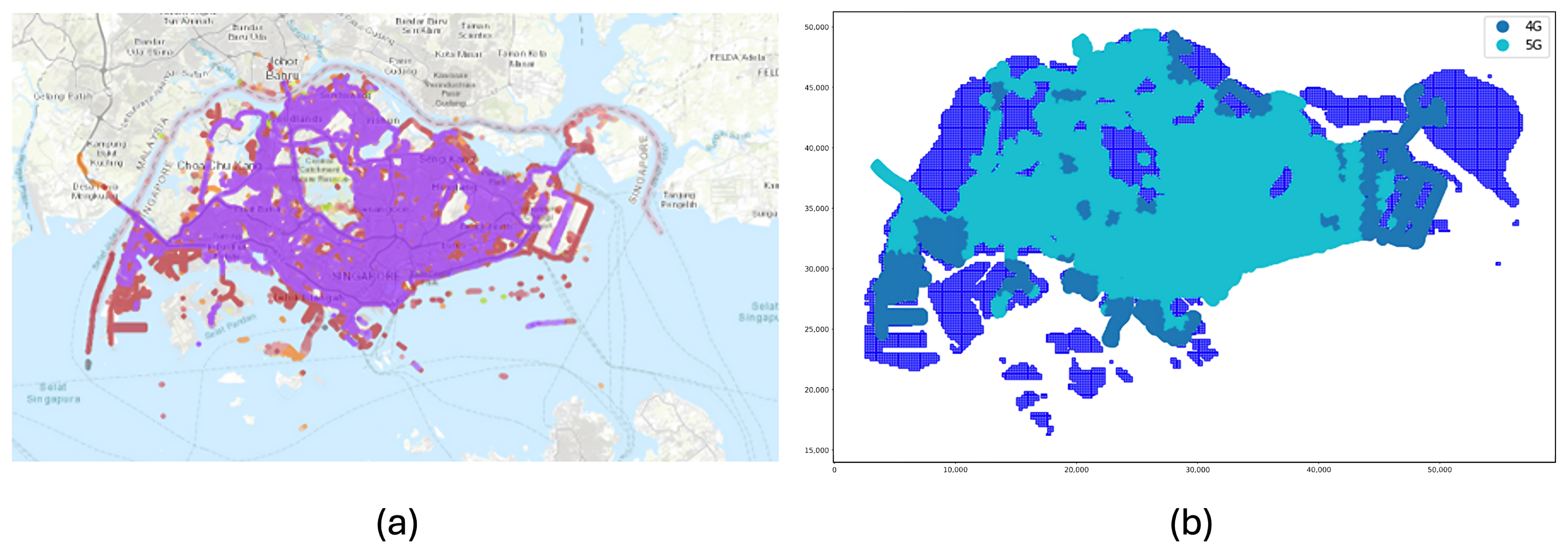
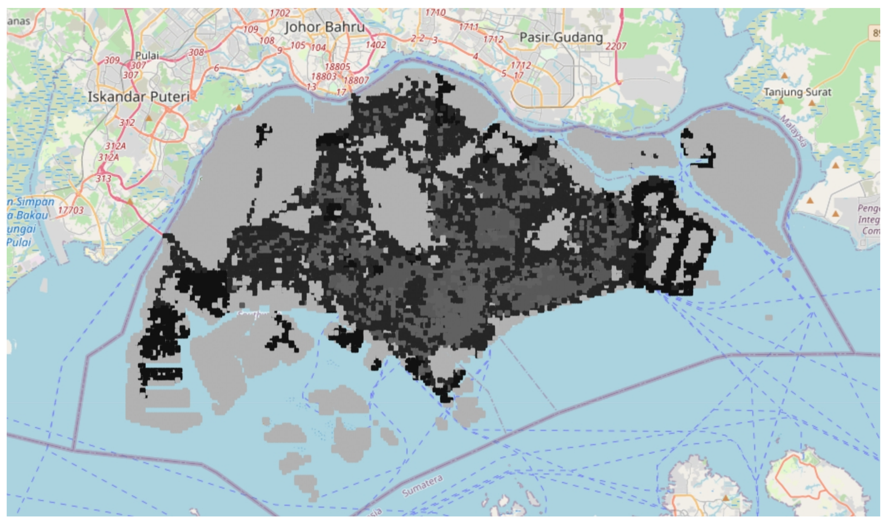
| 11 | Signal strength | Network strength data | Image | Using image processing, the number of points within each block was obtained. Differentiating each point based on their color gives insight into the signal strength associated with the block |
| 12 | High strength | Network strength data | Image | In the data source, the dark green points were high strength points |
| 13 | Moderate strength | Network strength data | Image | Light green points were classified as medium strength |
| 14 | Weak strength | Network strength data | Image | All other points belong to weak strength areas. Signal_strength = High strength + Moderate strength + Weak strength |
| 15 | Coverage strength | Coverage data | Image | Coverage Strength = 5G + 4G. Similar to network strength, all points within a block were classified as 4G or 5G based on their color |
| 16 | 5G | Coverage data | Image | The purple points belong to 5G coverage areas |
| 17 | 4G | Coverage data | Image | All nonpurple points belong to 4G coverage areas. |
| Cluster | Avg. No. Towers | Avg. No. Building Elements | 3/4G Coverage | 5G Coverage |
|---|---|---|---|---|
| 1 | 0.5 | 17.0 | 1.22 | 1.12 |
| 2 | 7.8 | 113.5 | 6.59 | 6.48 |
| 3 | 2.3 | 71.3 | 6.93 | 0.10 |
| 4 | 33.1 | 269.1 | 6.84 | 6.79 |
| 5 | 9.1 | 1042.6 | 6.80 | 6.44 |
| Cluster | |||
|---|---|---|---|
| 1 | 0.748 | 0.007986 | 0.668 |
| 2 | 0.770 | 0.006944 | 0.701 |
| 3 | 0.765 | 0.005903 | 0.706 |
| 4 | 0.736 | 0.004861 | 0.687 |
| 5 | 0.751 | 0.006250 | 0.689 |
Disclaimer/Publisher’s Note: The statements, opinions and data contained in all publications are solely those of the individual author(s) and contributor(s) and not of MDPI and/or the editor(s). MDPI and/or the editor(s) disclaim responsibility for any injury to people or property resulting from any ideas, methods, instructions or products referred to in the content. |
© 2025 by the authors. Licensee MDPI, Basel, Switzerland. This article is an open access article distributed under the terms and conditions of the Creative Commons Attribution (CC BY) license (https://creativecommons.org/licenses/by/4.0/).
Share and Cite
Liu, Q.; Dai, W.; Yan, Z.; Tessone, C.J. An Intelligent Path Planning System for Urban Airspace Monitoring: From Infrastructure Assessment to Strategic Optimization. Smart Cities 2025, 8, 100. https://doi.org/10.3390/smartcities8030100
Liu Q, Dai W, Yan Z, Tessone CJ. An Intelligent Path Planning System for Urban Airspace Monitoring: From Infrastructure Assessment to Strategic Optimization. Smart Cities. 2025; 8(3):100. https://doi.org/10.3390/smartcities8030100
Chicago/Turabian StyleLiu, Qianyu, Wei Dai, Zichun Yan, and Claudio J. Tessone. 2025. "An Intelligent Path Planning System for Urban Airspace Monitoring: From Infrastructure Assessment to Strategic Optimization" Smart Cities 8, no. 3: 100. https://doi.org/10.3390/smartcities8030100
APA StyleLiu, Q., Dai, W., Yan, Z., & Tessone, C. J. (2025). An Intelligent Path Planning System for Urban Airspace Monitoring: From Infrastructure Assessment to Strategic Optimization. Smart Cities, 8(3), 100. https://doi.org/10.3390/smartcities8030100