Review

Earthquake Risk Severity and Urgent Need for Disaster Management in Afghanistan

by
Noor Ahmad Akhundzadah
Department of the Natural Resources and the Environment, School of Agriculture and Life Sciences, Cornell University, Ithaca, NY 14853, USA
GeoHazards 2025, 6(1), 9; https://doi.org/10.3390/geohazards6010009
Submission received: 25 January 2025 / Revised: 12 February 2025 / Accepted: 17 February 2025 / Published: 19 February 2025
(This article belongs to the Special Issue Active Faulting and Seismicity—2nd Edition)

Abstract

:
Afghanistan is located on the Eurasian tectonic plate’s edge, a highly seismically active region. It is bordered by the northern boundary of the Indian plate and influenced by the collisional Arabian plate to the south. The Hindu Kush and Pamir Mountains in Afghanistan are part of the western extension of the Himalayan orogeny and have been uplifted and sheared by the convergence of the Indian and Eurasian plates. These tectonic activities have generated numerous active deep faults across the Hindu Kush–Himalayan region, many of which intersect Afghanistan, resulting in frequent high-magnitude earthquakes. This tectonic interaction produces ground shaking of varying intensity, from high to moderate and low, with the epicenters often located in the northeast and extending southwest across the country. This study maps Afghanistan’s tectonic structures, identifying the most active geological faults and regions with heightened seismicity. Historical earthquake data were reviewed, and recent destructive events were incorporated into the national earthquake dataset to improve disaster management strategies. Additionally, the study addresses earthquake hazards related to building and infrastructure design, offering potential solutions and directions to mitigate risks to life and property.

1. Introduction

Tectonic earthquakes in the Himalayan region result from the subduction of the Indian continental plate under the Eurasian plate [1,2]. The Hindu Kush Mountains, part of this active tectonic region, extend from the northeastern to southeastern parts of Afghanistan and into surrounding areas [2,3]. The region underwent intensive folding, thrusting, and faulting during the Mesozoic and Cenozoic eras. These deformations in the Himalayan region generally follow northwest-southeast and east-west trends [4]. The northward underthrusting of the Indian crust beneath Eurasia generates numerous earthquakes, making the region one of the most seismically hazardous areas on Earth [5,6]. This region frequently experiences destructive earthquakes, propagating seismic waves throughout Afghanistan and surrounding regions [7,8]. Consequently, northeastern Afghanistan is at the center of high earthquake hazards.
Afghanistan has been affected by destructive seismic activity for centuries, particularly in its northeastern region [8]. Annually, the country experiences moderate to strong earthquakes that cause damage, economic losses, and fatalities [9]. Since 1900, there have been approximately 100 damaging earthquakes recorded [10]. Over the past 30 years, earthquakes have resulted in more than 10,000 fatalities [11]. Strong earthquakes occur every few years in and around Afghanistan. For instance, a Mw7.5 earthquake in the Hindu Kush Mountains in 2015 caused 117 fatalities and destroyed over 7000 houses [12]. In 2019, an Mw6.1 earthquake struck Badakhshan province, while in 2021, an Mw5.1 earthquake hit Kabul with no fatalities and minimal damage [13]. In June 2022, a Mw6.2 earthquake struck southeastern Afghanistan, resulting in over 1163 fatalities, 3600 injuries, and the destruction of about 1000 houses [14]. More recently, on 21 March 2023, a Mw6.5 earthquake shook Jurm, a mountainous area in Badakhshan, without causing any fatalities. Aftershocks and recurring activity near the main shock centers followed each earthquake.
Several factors exacerbate Afghanistan’s impact and vulnerability to earthquake hazards, including the distribution of active faults, settlements in disaster-prone areas, unreinforced buildings, and the lack of a comprehensive disaster management system. Additionally, poverty, conflict, and instability in the country contribute to its susceptibility [15]. Therefore, effective earthquake disaster management is essential for reducing risk and vulnerability, and it forms the foundation for the country’s long-term sustainability. Over the past two decades, Afghanistan’s disaster risk management efforts have focused on response and recovery [16]. However, the Government of the Islamic Republic of Afghanistan (GoIRA), working with development partners like the World Bank, United Nations agencies, and international NGOs, has also initiated efforts to develop Disaster Risk Management (DRM) systems and integrate Disaster Risk Reduction (DRR) into national development strategies [17]. GoIRA included DRM and DRR in its national development strategy [18,19]. Despite these efforts, many DRM and DRR policies and plans remained in draft form [20]. The prolonged war and conflict further exacerbate Afghanistan’s vulnerability to natural disasters [21]. Insecurity and conflict contribute to state fragility, increasing socioeconomic vulnerability, while natural disasters cause frequent loss of lives, livelihoods, and property, resulting in migration and displacement [22,23]. These interconnected issues intensify the impacts of disasters, even though Afghanistan has significant potential to mitigate disaster risks.
Numerous studies have examined various aspects of earthquakes in and around Afghanistan—a region within a significant tectonic zone. While the most important studies have been cited in this paper, no research has focused on earthquake disaster exposure, risk vulnerability, disaster risk reduction, disaster management, and resilience. To address this gap, this study reviews the region’s tectonic structure, geological faults, and historical seismicity. This study further examines disaster-prone areas, evaluates the quality of construction relative to earthquake intensity, and assesses the socioeconomic and environmental vulnerabilities associated with seismic hazards in Afghanistan. Based on this comprehensive review, strategies for effective disaster management and earthquake risk mitigation are proposed. The paper concludes with policy recommendations and outlines directions for future research in this critical area.

1.1. Tectonic Structure of Afghanistan

Afghanistan is situated on the edge of the Eurasian plate within the active tectonic region of the Alpine–Himalaya orogenic belt. This belt was formed during the ongoing collision between the Indian, Arabian, and Eurasian plates, a process that began in the Late Paleogene and continues to the present day [24,25], as illustrated in Figure 1. Afghanistan shares hundreds of kilometers of active plate boundaries along its western, southern, and eastern edges. To the west, the Arabian plate moves northward relative to the Eurasian plate at a rate of approximately 31 mm/year [26]. This active boundary extends northwestward through the Zagros region of southwestern Iran [27]. The plate motion in this region has significantly deformed Iran and the surrounding areas, creating major structural features, including north–south-trending and right-lateral strike-slip fault systems along Iran’s eastern boundary with Afghanistan. East–west-trending reverse and strike-slip faults are intermittently distributed throughout Afghanistan [9].
Along Afghanistan’s eastern margin, the Indian plate moves northward relative to the Eurasian plate at an average rate of about 34.4 mm/year [28]. The collision between the Indian and Eurasian plates occurs at various measured rates, averaging ~13 mm/year [29,30]. This ongoing collision has created a broad, transpressional plate boundary zone that trends southwestward from the Hindukush region in northeastern Afghanistan, through Kabul, and along the country’s eastern side [31]. This zone features major north–northeast–trending, left-lateral strike-slip faults and is characterized by historical and contemporary seismic activity.
The Makran subduction zone, a region of significant geological activity, lies between the overriding Eurasian and subducting Arabian plates (Figure 1). This zone results from the northward subduction of the oceanic portion of the Arabian plate beneath the Lut and Afghan blocks in the northwestern Indian Ocean [32,33]. The region’s tectonic setting is complex due to its location at a triple junction with the Indian plate. Southwestern Pakistan, southeastern Iran, and southernmost Afghanistan comprise a broad transpressional fold and thrust belt characterized by south–southeast-verging, north-dipping thrust faults and associated east–northeast-trending folds [34,35]. This seismically active area frequently produces large-magnitude earthquakes, including a recent Mw7.7 earthquake in September 2013 in Balochistan Province [32].
Seismicity increases in northeastern Afghanistan, where a zone of deep earthquakes is associated with the northward subduction of the Indian plate beneath Eurasia. This zone, a promising area for future research, extends beneath the Hindukush and Pamir Mountains [9,36]. In the Pamir and Hindukush regions, the seismogenic zone starts at a depth of 50 km, extending to around 250 km, and displays several subduction-related features, such as crustal thrust faults and a local zone of high seismicity [37,38].
Some faults in Afghanistan are considered active based on historical records, recent significant earthquake activity, and surface ruptures. Earthquakes in Afghanistan and the surrounding region have caused, and will likely continue to cause, severe damage through solid ground shaking, surface fault ruptures, liquefaction, and landslides. This underscores the urgent need for continued monitoring. Notably, on 22 June 2022, a devastating Mw6.2 earthquake struck southeastern Afghanistan, causing widespread destruction [14,39].

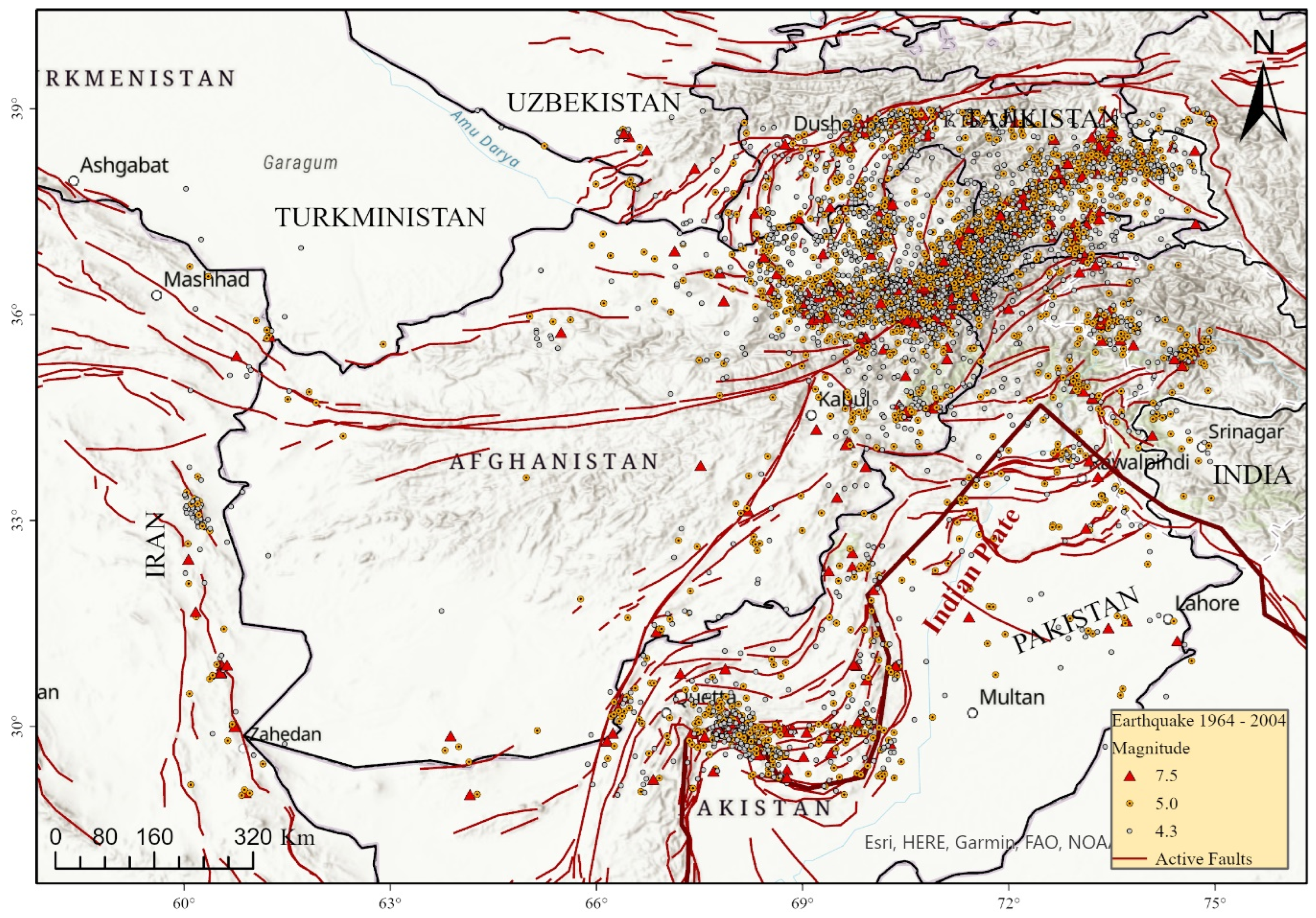
1.2. Regional Tectonic Framework and Associated Fault Systems

The Hindu Kush and Pamir Mountains in Afghanistan are part of the Himalayan orogeny, uplifted by the collision between the Indian and Eurasian plates. This tectonic event and its associated movements have generated several active deep faults in the Hindu Kush–Himalayan region, extending across Afghanistan [25,40], as shown in Figure 2. The boundary of the Himalayan tectonic region extends to the foothills of the Sulaiman Mountains in the west, the Indo-Burmese Arc in the east, and the Himalayan Front in northern India [41]. Earthquakes in this region are the episodic release of accumulated tectonic strain and stress, resulting in motion or slip between crustal blocks and causing significant damaging shaking [42]. Additionally, the relative motion between the Indian and Eurasian plates in the west and south of the Himalayan front is oblique, leading to strike-slip, reverse-slip, and oblique-slip earthquakes, as well as associated displacement along faults and fault zones [28,43]. As illustrated in Figure 2, Afghanistan and neighboring countries share the same tectonic region and exhibit a similar tectonic structure. The fault systems that traverse Afghanistan also extend into the surrounding regions. Ruleman and others identified any fault within 100 km of Afghanistan’s political borders as a potential threat to the country’s population and infrastructure [44].
The primary active fault systems in Afghanistan include the Chaman, Hari Rud, Central Badakhshan, and Darvaz faults, along with numerous more minor subsidiary faults and fault zones that accommodate movement between these major faults [31,44,45]. These faults are associated with both shallow and deep high-magnitude earthquakes. Figure 2 highlights earthquakes that occurred in the region between 1964 and 2004, adapted from the USGS database [27]. High-magnitude earthquakes along these fault systems have recently impacted Afghanistan and surrounding areas [5,46]. In the western part of the country, earthquake activity originating from the Arabian Plate has caused deadly quakes in eastern Iran [33].

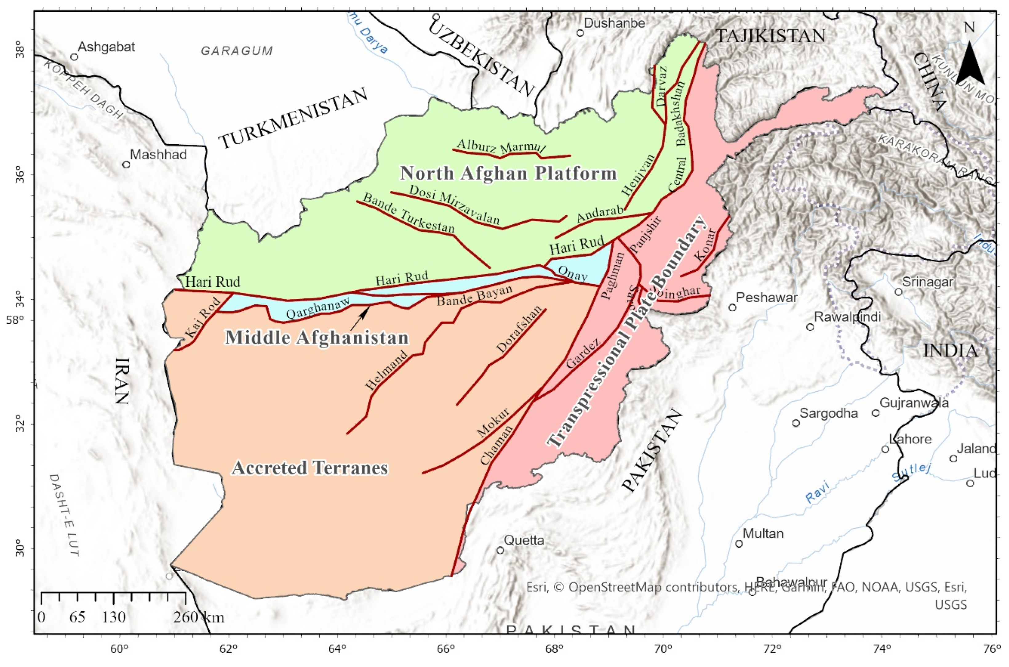
1.3. Tectonic Zones of Afghanistan

Afghanistan consists of a complex assemblage of crustal and oceanic blocks, forming several unique terranes that were welded onto the southern margin of the Eurasian plate during a series of accretionary events beginning in the Paleozoic and continuing to the present [44,47,48,49]. The geological structure of Afghanistan is dominated by the Mesozoic (Cimmeride) and Tertiary (Himalayan) orogenic episodes, which have shaped and continue to shape the country’s mountainous regions and dramatic landscape [50,51]. Afghanistan has been classified into four distinct seismotectonic regions, each with different geological histories and structures [45,48,52], as outlined in Figure 3.
The Transpressional Plate Boundary region marks the boundary between the Eurasian and Indian plates, resulting from continental collision and moving northward at a rate of approximately 39 mm per year [31,44]. This boundary is located south and east of the Afghan Block. It includes the eastern portion of the Hindu Kush and Pamir Mountain ranges and the Sulaiman fold-and-thrust belt in southern Afghanistan (Figure 3). The western and northern boundaries of this zone are defined by the left-lateral Chaman and Central Badakhshan fault systems, respectively. The Chaman fault, in particular, exhibits significant tectonic activity, including recent earthquakes, making it the most seismically active zone in Afghanistan, except for the eastern part of the North Afghan Platform.
The North Afghan Platform lies north of the Hari Rud fault zone and west of the Central Badakhshan fault system, encompassing the Tajik Basin [31,44] (Figure 3). The Darvaz fault is particularly active in this region. This zone represents the southern margin of the Eurasian continental plate and is relatively tectonically stable. It comprises a deformed basement of metamorphic and igneous rocks formed during the Carboniferous-Permian Hercynian Orogeny [39]. The eastern part of the North Afghan Platform, incorporating the Darvaz fault, is more seismically active than the rest of the platform.
Middle Afghanistan is a narrow zone located immediately south of the North Afghan Platform and forms part of the right-lateral Hari Rud fault zone [31,44]. It acts as the boundary between the North Afghan Platform, the Afghan Block, and other terranes to the south [49]. The Hari Rud River flows along a central downfaulted graben within the suture, south of the Paropamisus Mountains. The Accreted Terranes region lies south of Middle Afghanistan and includes numerous external folded, faulted, partially metamorphosed, and deformed blocks. These blocks form the mountains and plains of the Farah, Helmand, and Arghandab areas, created during the Mesozoic Cimmerian Orogeny, which involved the closing of the Paleo-Tethys Ocean [31,44,53] (Figure 3). This region is seismically quiescent.
Identifying these tectonic zones, as per [31,44], allows for the distribution of earthquake magnitudes across various faults and regions of Afghanistan. Generally, tectonic activities, earthquakes, and deformation in Afghanistan and the surrounding region are driven by the collision between the northward-moving Indian and Eurasian plates [44,54]. This movement has created active Quaternary faults across the country, producing moderate-to-high-magnitude, potentially damaging earthquakes. Afghanistan’s crust is segmented by a complex fault network of various ages and directions of movement, as shown in Figure 2. Ancient earthquakes along these faults have caused varying degrees of slip over time. Due to the temporal and spatial migration of stress and strain within the region, some faults remain active, causing recent destructive earthquakes, while others have become dormant or quiescent [55,56,57].

2. Methods and Data

The data for this study were obtained from a wide range of sources, including published research papers, technical reports, books, and specialized earthquake and tectonic databases. Historical geological and geotechnical investigations in and around Afghanistan can be traced back to the 1900s or before [5,10], and stopped by the Soviet invasion in 1979 [58]. However, decades of protracted conflict have severely compromised Afghanistan’s data-recording infrastructure, limiting the availability of accurate information [22,59]. Inconsistent geo-disaster and disaster vulnerability data further challenge effective national-level disaster risk management (DRM). Moreover, ongoing security concerns have restricted field observations and data collection, resulting in significant gaps in the seismic record.
Recent work by the USGS has focused on seismic activities in Afghanistan, particularly regarding geological faults, seismic zones, and the development of earthquake hazard maps [60]. The USGS has also established a historical earthquake database [27,60,61]. In this study, Afghanistan’s tectonic settings, active faults, and seismic regions were digitized and mapped using updated data in ArcGIS Pro 3.4.2 [62]. Historical and recent earthquake records were obtained from the Risklayer online database [13]. Furthermore, the principal geological faults traversing Afghanistan and their connections to adjacent regions and plate boundaries were derived from the ArcGIS REST Services Directory [29,63]. Newly available earthquake records were integrated into the USGS historical earthquake database. Topographical maps and satellite imagery were sourced from multiple providers, including Esri, USGS, the Food and Agriculture Organization (FAO), and the National Oceanic and Atmospheric Administration (NOAA).
The methodology of this study comprises a comprehensive review and analysis of metadata from various reports, academic papers, related databases, and published sources supplemented by the author’s professional experience. The earthquake database, historical earthquake map, and hazard map were updated and digitized using the latest available data. Independently generated maps detailing Afghanistan’s tectonic settings and geological faults were produced, and the country’s socioeconomic and infrastructural vulnerability to earthquakes was assessed. Based on these analyses, recommendations for earthquake disaster management in Afghanistan and future research have been proposed.

3. Results and Discussions

The tectonic boundaries and faults in and around Afghanistan create concentrated zones where the Earth’s crust is under stress, leading to episodic ruptures or movements manifesting as earthquakes. Earthquakes have caused significant destruction in Afghanistan, particularly near fault zones and tectonic boundaries between Afghanistan and the surrounding area (Figure 2 and Figure 3). The historical records of seismic events show that the country has experienced recurrent and powerful earthquakes, some of which originated in surrounding countries but had severe impacts within Afghanistan. A key challenge in Afghanistan is the widespread vulnerability of infrastructure and populations to seismic activities. Earthquake-resistant infrastructure is uncommon, and many areas, especially rural regions, are densely populated without proper disaster mitigation strategies. The lack of early warning systems, emergency preparedness, and infrastructure to withstand earthquakes exacerbates the risk. While earthquakes cannot be predicted, their risk can be mitigated by reducing people’s and infrastructure exposure and vulnerability through infrastructure improvements, education, and strategic urban planning. The following sections discuss historical earthquakes in Afghanistan, infrastructure vulnerability, and population risk.

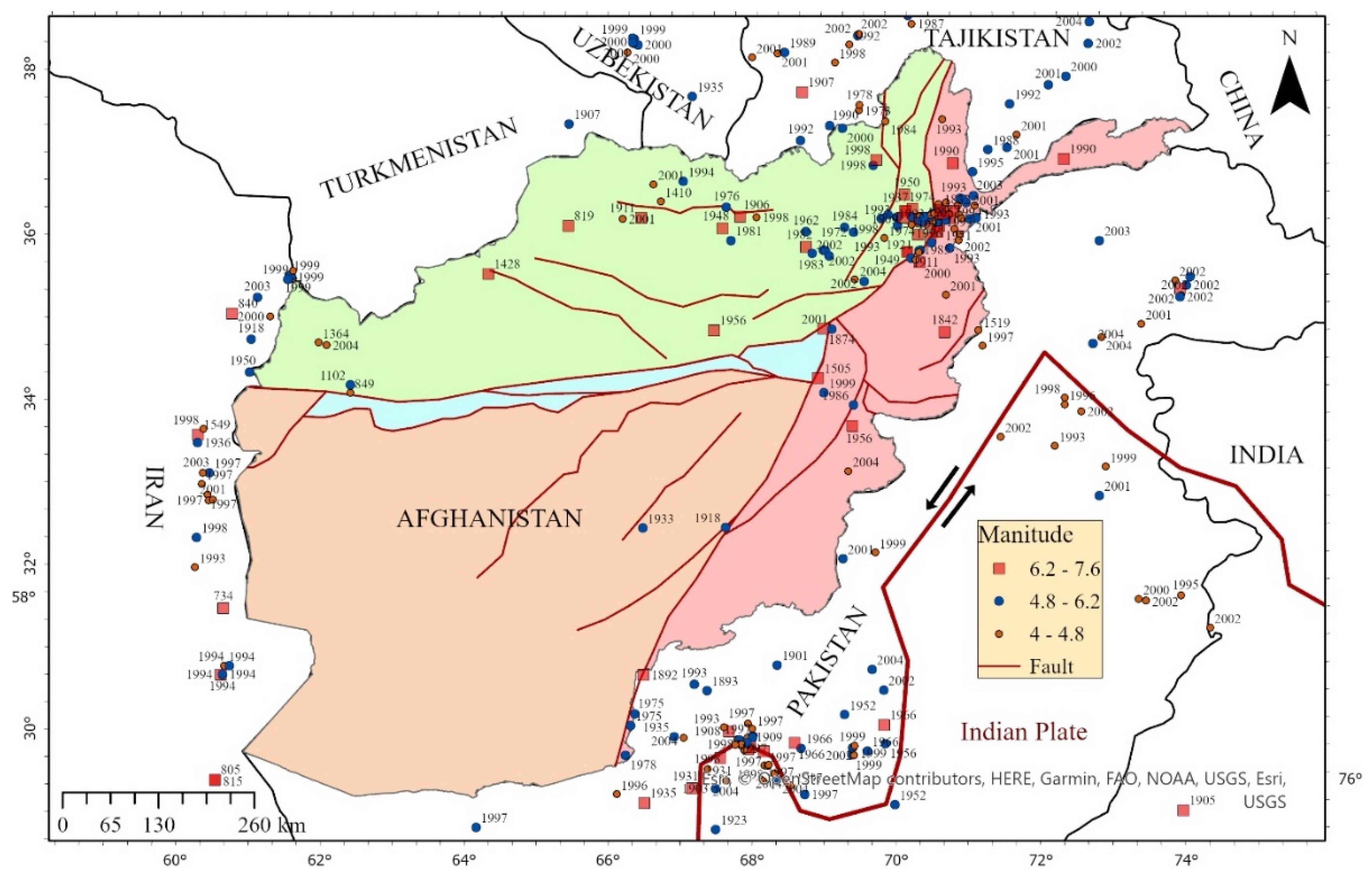
3.1. Historical Earthquakes in Afghanistan

The historical earthquake records offer crucial insights for hazard assessment and disaster risk management, particularly as population growth and vulnerable infrastructure have amplified the risk of earthquake-induced damage. Research on Afghanistan’s seismic history has faced considerable challenges, mainly due to protracted conflict and the destruction of research institutions. Despite these setbacks, modern efforts have resumed to collect and analyze seismic data. The USGS, for instance, has developed a database to map the country’s earthquake vulnerabilities. This work follows earlier contributions from researchers like [27,60], who investigated Afghanistan’s historical seismicity (Figure 4). These studies indicate that earthquakes have been documented for over a millennium, with records dating back to A.D. 734. One of the earliest notable earthquakes occurred in A.D. 819, with an estimated magnitude of Ms7.4 in northern Afghanistan, causing extensive destruction and numerous casualties. Compiling more than 1300 historical earthquakes in the database, these records help create a foundational understanding of Afghanistan’s seismic risks. The United Nations Environmental Program (UNEP) [64,65,66] has also contributed to this effort, emphasizing the intersection of environmental disasters and earthquake risk. Their work, alongside that of the World Bank [11], highlights the need for comprehensive disaster risk profiles to inform risk management strategies in the region. Given Afghanistan’s history and current seismic vulnerability, robust earthquake disaster mitigation measures, strengthened data collection, and research infrastructure are critical for its long-term resilience.
Figure 5 illustrates the locations, magnitudes, and focal depths of historic earthquakes within Afghanistan and its surrounding regions. Earthquakes are classified based on focal depth: shallow earthquakes occur between 0 and 70 km, intermediate-depth earthquakes range from 70 to 300 km, and deep-focus earthquakes occur between 300 and 700 km [67]. Intermediate-depth earthquakes result from deformation within the subducted lithosphere beneath the Eurasian Plate rather than the shallow interfaces between the subducting and overriding plates. These earthquakes generally cause less surface damage than shallow-focus earthquakes of similar magnitude. However, large intermediate-depth earthquakes can be felt over great distances. Occasionally, deep-focus earthquakes exceeding 300 km also occur beneath northeastern Afghanistan [68].
Afghanistan’s most tectonically active area is the Transpressional Boundary region (Figure 3), which includes the Hindukush deep seismic zone, known for high-magnitude deep earthquakes. In contrast, the central and western parts of the country remain largely seismically inactive. The left-lateral, strike-slip Chaman fault also marks the southeastern region, Afghanistan’s fastest-moving fault. For example, a segment of the Chaman fault near Kabul ruptured in 1505, causing widespread devastation. Another significant event was the M7.6 earthquake in Quetta on 30 May 1935, which occurred in the Sulaiman Range, killing 30,000 people and affecting 60,000 more beyond Afghanistan’s borders. In Afghanistan, even moderate earthquakes with magnitudes between 5.0 and 5.9 have caused considerable destruction and fatalities, which is why the earthquake catalog includes all events with magnitudes greater than M5.

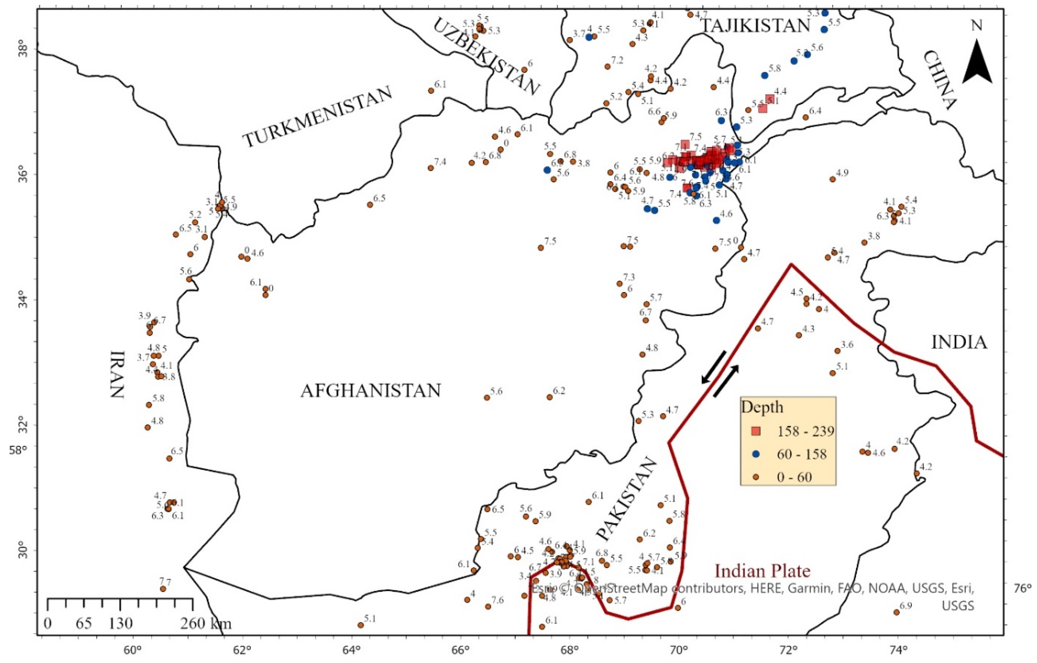
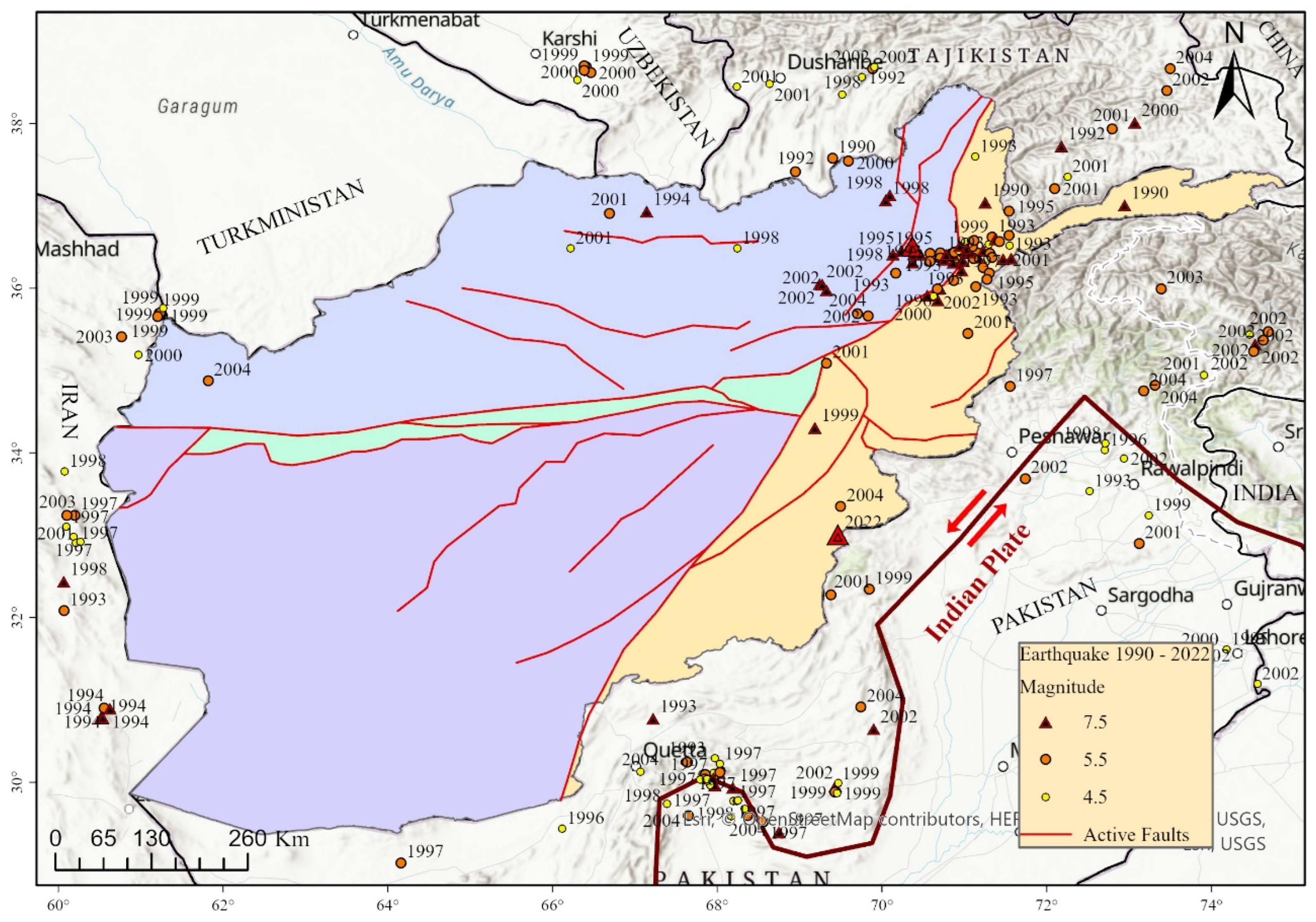
3.2. Recent Seismicity and Earthquakes in Afghanistan

Figure 6 illustrates the seismotectonic map of Afghanistan and its surroundings, highlighting recent earthquakes from 1990 to 2004. This period saw a significant number of seismic events, with some notably destructive ones summarized below:
21 June 2022: A magnitude M6 earthquake with a 40 km deep epicenter struck near Khost Province [69]. This earthquake resulted in 1150 casualties, 3000 injuries, and damaged 10,000 homes across Khost and Paktika provinces [61]. The most affected areas in Khost were Sperah and Barmal, while Nikeh, Ster Giyan, and the Ziruk area in Paktika Province were also severely impacted. The earthquake caused a landslide in Khost, which killed ten people and injured 25. The event was characterized by predominantly strike-slip faulting, with either a left-lateral slip on a northeast-striking fault or a right-lateral slip on a northwest-striking fault [46,61].
26 October 2015: An M7.5 magnitude earthquake occurred southwest of Jurm in Badakhshan Province, near the Hindukush region. This event was due to reverse faulting at an intermediate depth, approximately 210 km below the Hindukush Range in northeastern Afghanistan [70]. Focal mechanism solutions suggest rupture on either a steep, south-dipping reverse fault or a shallow, north-dipping thrust fault.
October 2005: The deadliest earthquake in recent history struck the Kashmir region of Pakistan, near the eastern border of Afghanistan, with significant regional impacts [71]. March 2002: An M7.4 magnitude earthquake struck just 20 km west of the 26 October 2015 event, with similar depth and thrust fault orientation. This earthquake caused over 150 fatalities and damaged or destroyed over 400 houses due to a seismogenic landslide. In December 1983, an M7.4 earthquake occurred at a similar depth, 8 km south of the 26 October 2015, event. This quake resulted in 26 fatalities, hundreds of injuries, and extensive infrastructural damage.

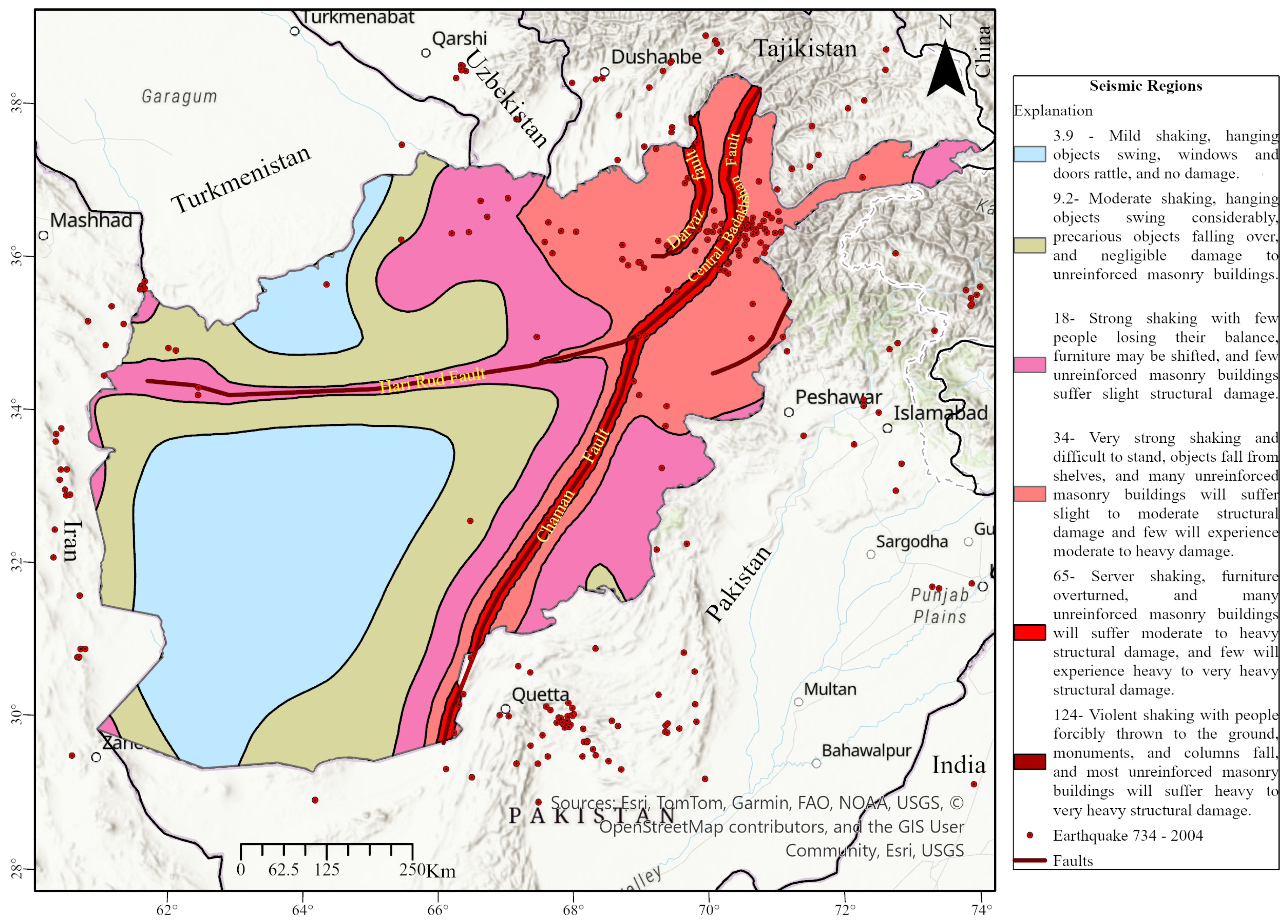
3.3. Earthquake Hazard Map of Afghanistan

Figure 7 illustrates the earthquake hazard map of Afghanistan, segmented into six seismic regions categorized by shaking intensity, ranging from low (light blue) to high (red). USGS initially developed this hazard map [9]. The region near the Central Badakhshan, Darvaz, and Chaman faults has experienced the highest levels of shaking and destruction from historical earthquakes. It also exhibits the most significant geomorphic evidence of ongoing tectonism [43,44], thus indicating the highest seismic hazard. The second-highest seismic hazard is found in the dispersed areas associated with these major fault zones. Shaking and major events along the faults resonate and attenuate throughout these regions. The most seismically active areas extend from the Darvaz–Badakhshan fault system in the east to the North Afghan Platform in central-western Afghanistan, marking a significant transpressional plate boundary zone.
The region marked in pink represents the third highest seismic activity, notably around the Hari Rud fault. In the western part of the country, the Arabian fault and transtensional strike-slip faulting along the Iran–Afghanistan border contribute to seismic activity [72,73,74]. The remaining regions are relatively seismically calm, primarily covering the accreted terranes.

3.4. Socioeconomic and Environmental Vulnerability to Earthquakes in Afghanistan

Afghanistan is characterized by its rugged mountainous terrain and expansive deserts that bridge Central and South Asia. Despite its rich cultural heritage, the country has undergone limited modernization and relies heavily on traditional practices. Approximately 71% of the population resides in rural areas [75], and agriculture continues to serve as the backbone of the economy [76].
Historically, Afghan settlements developed around vital water resources in mountainous valleys [77]. These valleys often coincide with geologically active fault lines, placing essential agricultural lands and water supplies at significant risk. Traditional construction methods, primarily unreinforced mud, brick, and masonry, are highly susceptible to seismic damage [78]. Even in urban centers, many buildings lack adequate seismic reinforcement [79]. When earthquakes strike, the damage is often extensive. Villages built along these fault lines are repeatedly devastated by seismic activity, and the rebuilding process typically reverts to the same traditional methods. Rapid population growth further exacerbates this cycle of destruction. For example, while Afghanistan’s population was estimated at 11 million in 1970, it surged to 41 million by 2021 [80]. In some cases, traditional adobe homes have been replaced by hastily constructed multi-story apartment blocks that offer slight improvement in structural safety. As a result, even moderate earthquakes can lead to a disproportionate loss of life and widespread destruction outcomes rarely observed in developed nations [79,81]. Moreover, the proximity of many towns and cities to active fault lines further heightens the risk [39]. This pattern of vulnerability is not unique to Afghanistan; similar trends are evident across parts of Western, Central, and South Asia [82].
Afghanistan is also recognized as one of the most climate-vulnerable countries globally [83], with the impacts of climate change further compounded by political, geographic, and social factors. Key climate change effects include rising temperatures, decreased and erratic precipitation, and dwindling water resources [84,85,86]. These changes reduce green cover, negatively impact agriculture, and contribute to the onset of droughts [87,88]. Additionally, irregular precipitation patterns and early seasonal warming have increased the incidence of floods [89,90]. Ongoing environmental degradation, such as deforestation, unsustainable agricultural practices, and overexploitation of water resources, further diminishes the landscape’s natural resilience [66,91], elevating disaster risk. These environmental stressors compromise the nation’s vital natural resources, particularly water and agriculture, compounding the threat posed by earthquakes [92]. Moreover, extreme events such as floods, droughts, and earthquakes are increasingly interlinked, leading to chronic food insecurity, economic instability, and community displacement [89,93,94,95,96].
Afghanistan’s vulnerability to geo-disasters is further intensified by prolonged conflict and instability, severely undermining its socio-economic and environmental infrastructure [97]. The cycle of the conflict began with the Soviet Union’s invasion in 1979 and persisted even after their withdrawal in 1989 [98,99]. Subsequent civil strife among various armed groups during the 1990s and the emergence of the Taliban in 1994 further escalated the conflict [100,101]. The ongoing strife has significantly degraded Afghanistan’s physical, social, and economic structures, with war and natural disasters reinforcing one another and leading to insecurity, extreme poverty, weak governance, underdevelopment, migration, and overall socioeconomic decline [21,59,102].
Despite Afghanistan’s long history of seismic activity, disaster management efforts remain inadequate. Contributing factors include high population densities in vulnerable rural areas, limited technical expertise in emergency preparedness, and continuous environmental degradation, further compounded by ongoing conflict. Together, these challenges create an exceptionally high-risk profile for human and infrastructural losses during seismic events.

3.5. Construction Vulnerability Against Earthquake

Various factors, including age, construction materials, design, location, and maintenance practices, influence buildings’ vulnerability to earthquakes. Research has shown that older structures built with unreinforced masonry, brick, mud, or non-ductile concrete are particularly prone to seismic damage [103,104,105]. In contrast, modern buildings that incorporate proper construction materials, adequate reinforcement, and robust foundation designs are better equipped to withstand seismic forces. Equally important are the properties of the foundation soil and surrounding geological formations, as well as ongoing building maintenance, all of which play critical roles in reducing earthquake-induced damage [106,107].
Geotechnical investigation is a crucial component in mitigating seismic risks. Detailed assessments of subsurface soil conditions allow engineers to tailor foundation designs and structural systems to a site’s specific seismic characteristics, thereby enhancing overall construction resilience [108]. Moreover, in earthquake-prone areas, the enforcement of stringent building codes and the implementation of proper reinforcement techniques are essential for maintaining structural integrity during seismic events [9,109].
In Afghanistan, traditional construction practices have often overlooked modern safety standards, particularly in disaster-prone regions. Historically, many Afghan houses, especially in rural areas, have been built using traditional materials such as stone, mud (adobe), and brick masonry, resulting in a housing stock highly susceptible to earthquake damage [78]. While urban centers have seen the construction of reinforced concrete (RC) buildings, these too can be vulnerable if they are not designed or constructed strictly following seismic codes [105].
Before 1970, cities such as Kabul, Herat, Mazar-e-Sharif, and Nangarhar featured many well-constructed public RC buildings that demonstrated a degree of seismic resilience [110,111]. However, decades of conflict have severely impacted Afghanistan’s built environment. Following the establishment of the Government of the Islamic Republic of Afghanistan (GoIRA) in 2002, with strong international support [112], the country experienced rapid urbanization. Kabul, in particular, underwent dramatic changes as returning refugees and rural migrants swelled the city’s population from approximately 1.78 million in 1999 to 4 million by 2008 [113,114]. This explosive growth led to an expansion of Kabul’s territory to over 1022 km2, often characterized by irregular, unplanned development and substandard construction practices that neglected seismic codes and geotechnical investigations [115].
In response to these challenges, efforts have been made to improve building practices. The introduction of a national building code in 2012 [116] by GoIRA was intended to foster sustainable and resilient construction. Despite progress in both the public and private sectors, many structures continue to fall short of these standards, leaving Afghanistan’s infrastructure at high risk. Scientific approaches, such as those proposed by [9] for predicting ground shaking, offering promising avenues for enhancing construction practices, and guiding retrofitting efforts in the country [9]. Furthermore, upgrading building standards, retrofitting vulnerable structures, and launching public awareness campaigns are all critical steps toward reducing the seismic risk in Afghanistan [16,117]. To this end, Afghanistan’s construction landscape remains highly vulnerable to earthquakes due to a combination of traditional building methods, insufficient adherence to modern seismic codes, rapid and often unplanned urban expansion, and a lack of comprehensive geotechnical investigations. Addressing these issues through improved construction practices, stricter building code enforcement and informed engineering interventions is essential for mitigating future earthquake risks.

3.6. Earthquake Disaster Risk Reduction Measures in Afghanistan

Disaster risk management (DRM) and disaster risk reduction (DRR) are critical components of a comprehensive strategy to mitigate the impacts of disasters. DRM involves applying policies and strategies to prevent the emergence of new disaster risks, reduce existing ones, and manage residual risks, thereby strengthening resilience and reducing disaster losses [118]. In parallel, disaster management encompasses a cyclical process spanning prevention, mitigation, preparedness, response, and recovery that aims to lower vulnerability, enhance resilience, minimize losses, and facilitate learning from past events [119,120,121].
In Afghanistan, DRM and DRR efforts have faced significant challenges over the past two decades, primarily due to a heavy national focus on security, which has absorbed more than half of the national budget. Nonetheless, progress has been made through the support of international donors such as the World Bank, UN agencies, and various international NGOs. These external efforts have contributed to developing DRM systems and integrating DRR into the country’s development strategies [18,19]. GoIRA has incorporated DRM and DRR into national development plans; however, the focus has predominantly been on response and recovery activities rather than preventive measures. As a result, comprehensive disaster management frameworks remain underdeveloped, and significant gaps persist, particularly in the implementation of construction codes and the execution of comprehensive seismic assessments. Despite its limitations, early-stage hazard mapping is crucial for identifying vulnerable areas and guiding critical infrastructure design, such as power plants, dams, and major transportation routes.

Key Management Processes for Effective DRM and DRR

For Afghanistan to enhance its earthquake-related DRM and DRR, it is essential to integrate the following management processes into national plans [118,122]:
  • Prospective Disaster Risk Management: Focuses on preventing new or increased disaster risks by proactively implementing risk reduction policies. This forward-looking approach is vital for addressing risks that could develop if appropriate measures are not adopted.
  • Corrective Disaster Risk Management: Concentrates on mitigating existing risks. Immediate and targeted actions are required to effectively manage and reduce these existing hazards.
  • Compensatory Disaster Risk Management: Aims to strengthen the social and economic resilience of individuals and communities against residual risks that cannot be fully mitigated. This process includes preparedness, response, recovery activities, and financial instruments such as national contingency funds, contingent credit, insurance and reinsurance, and social safety nets.
  • Community-based Disaster Risk Management: Encourages active participation from potentially affected communities in all phases of disaster risk management. Involving local populations in hazard assessments, vulnerability analyses, and capacity evaluations ensures that DRR initiatives are relevant and sustainable.
  • Local and Indigenous Peoples’ Approach to Disaster Risk Management: This dual approach integrates traditional, indigenous, and local knowledge with scientific methods. It enriches disaster risk assessments and helps tailor local disaster management strategies that are culturally appropriate and contextually effective.

4. Conclusions and Recommendations

Afghanistan faces a high risk of devastating earthquakes due to its intense tectonic activity, a history of seismic events, and significant socio-economic vulnerabilities. Active geological faults, such as Chaman, Hari Rud, Central Badakhshan, and Darvaz, combined with chronic poverty, political instability, and inadequate disaster management systems, expose communities to severe impacts when natural hazards occur. Decades of conflict have further weakened governance structures, amplifying the potential for large-scale humanitarian and economic disasters.
To reduce these vulnerabilities and strengthen the nation’s resilience, the following integrated recommendations are proposed:
  • Establish a National Disaster Management System (DMS): Develop a comprehensive DMS that encompasses all phases of disaster management, mitigation, control, preparedness, response, and recovery. This system should be supported by a well-trained, well-equipped national and local team capable of risk analysis, resource mobilization, and effective response coordination. Community-based initiatives should be central to this approach.
  • Develop Comprehensive Earthquake Hazard Mapping: Create a detailed, scientifically robust earthquake hazard map using advanced geospatial and remote sensing technologies. This map should identify fault lines, vulnerable areas, at-risk populations, and critical assets, facilitating accurate risk assessments and identifying safer zones for relocation.
  • Improve Building Safety and Enforce Construction Standards: Update and enforce national construction codes to ensure that all structures, including masonry and mud buildings, are designed to withstand seismic forces. Strengthening building safety involves regularly reviewing and updating construction standards and providing support and training to poorer communities for effective implementation.
  • Reinforce Critical Infrastructure: Upgrade essential infrastructure such as power plants, dams, and transportation networks by incorporating seismic-resistant designs and targeted engineering interventions. These improvements are vital to ensuring that critical services remain operational during and after seismic events.
  • Enhance Earthquake Monitoring and Early Warning Systems (EWS): Invest in modern earthquake monitoring systems by establishing a comprehensive database, installing seismographs, and integrating remote sensing technologies. An effective EWS will provide timely alerts and facilitate rapid response, reducing potential losses.
  • Raise Public Awareness and Promote Community Preparedness: Educate communities about earthquake-resistant construction practices and the use of locally sourced, resilient building materials. Public awareness campaigns should also promote voluntary relocation from high-risk zones, supported by adequate governmental assistance for rebuilding in safer areas.
  • Foster Regional Cooperation and Knowledge Sharing: Engage with neighboring Western, Central, and South Asian countries to share best practices in disaster risk reduction. Collaborative efforts should include cross-border infrastructure projects and developing integrated early warning systems, enhancing regional resilience.

Future Research Directions

To further enhance understanding and improve policy measures, additional research is necessary in the following areas:
  • Geological and Seismic Investigations: Conduct detailed field studies of geological faults, tectonic zones, earthquake intensity, and ground shaking potential using ground-based state-of-the-art technology and remote sensing methods. Integrating these data into interactive mapping systems will improve risk assessment accuracy.
  • Micro-Level Vulnerability Assessments: Undertake detailed case studies at village, rural, and urban neighborhood levels to understand local construction practices, resource allocation, and community resilience. These assessments can provide tailored insights for localized interventions.
  • Climate Change and Seismic Risks: Explore the relationship between climate-change-induced environmental degradation and earthquake vulnerability, assessing how shifting ecological conditions might affect seismic risks.
  • Socioeconomic Interventions: Evaluate the impact of poverty reduction and sustainable development programs on disaster risk mitigation, comparing practices with those in other Western, Central, and South Asian countries to identify effective strategies.
  • Case Studies of Past Earthquakes: Document and analyze specific earthquake events in Afghanistan to understand how traditional construction methods, rapid urbanization, and ongoing conflict have compounded disaster impacts.
Implementing these recommendations and pursuing targeted research can significantly reduce Afghanistan’s vulnerability to seismic hazards. Strengthening disaster response capabilities, developing resilient infrastructure, and empowering communities through education and preparedness are essential steps toward mitigating the catastrophic impacts of future earthquakes. These measures will enhance immediate disaster response and contribute to the country’s long-term sustainable development and overall resilience.

Funding

This research received no external funding.

Data Availability Statement

No new data were created or analyzed in this study.

Acknowledgments

I sincerely thank the Department of Natural Resources and the Environment (DNRE), the South Asia Program (SAP), and the Einaudi International Center at Cornell University for providing invaluable resources, fostering an enriching academic environment, and facilitating connections within the scholarly community. I extend special thanks to the International Institute of Education, Scholar Rescue Fund (IIE-SRF) for their generous support of my fellowship. I am also profoundly grateful to Cal Ruleman of the Geosciences and Environmental Change Science Center, U.S. Geological Survey, for his thorough and insightful review of this paper.

Conflicts of Interest

The author declares no conflict of interest.

References

  1. Guo, X.; Li, W.; Gao, R.; Xu, X.; Li, H.; Huang, X.; Ye, Z.; Lu, Z.; Klemperer, S.L. Nonuniform Subduction of the Indian Crust beneath the Himalayas. Sci. Rep. 2017, 7, 12497. [Google Scholar] [CrossRef] [PubMed]
  2. Verma, R.K.; Mukhopadhyay, M.; Bhanja, A.K. Seismotectonics of the Hindukush and Baluchistan Arc. Tectonophysics 1980, 66, 301–322. [Google Scholar] [CrossRef]
  3. Chouhan, R.K.S. Seismotectonics of Hindukush. Pure Appl. Geophys. 1970, 82, 108–118. [Google Scholar] [CrossRef]
  4. Joshi, G.R.; Hayashi, D. Development of Extensional Stresses in the Compressional Setting of the Himalayan Thrust Wedge: Inference from Numerical Modeling. Nat. Sci. 2010, 2, 667–680. [Google Scholar] [CrossRef]
  5. Bilham, R. Himalayan Earthquakes: A Review of Historical Seismicity and Early 21st Century Slip Potential. In Geological Society Special Publication; Geological Society of London: London, UK, 2019; Volume 483, pp. 423–482. [Google Scholar]
  6. Hinsbergen, D.J. Indian Plate Paleogeography, Subduction and Horizontal Underthrusting below Tibet: Paradoxes, Controversies and Opportunities. Natl. Sci. Rev. 2022, 9, nwac074. [Google Scholar] [CrossRef]
  7. Kufner, S.K.; Kakar, N.; Bezada, M.; Bloch, W.; Metzger, S.; Yuan, X.; Mechie, J.; Ratschbacher, L.; Murodkulov, S.; Deng, Z.; et al. The Hindu Kush Slab Break-off as Revealed by Deep Structure and Crustal Deformation. Nat. Commun. 2021, 12, 1685. [Google Scholar] [CrossRef]
  8. Rehman, K.; Ali, W.; Ali, A.; Ali, A.; Barkat, A. Shallow and Intermediate Depth Earthquakes in the Hindu Kush Region across the Afghan-Pakistan Border. J. Asian Earth Sci. 2017, 148, 241–253. [Google Scholar] [CrossRef]
  9. Boyd, O.S.; Mueller, C.S.; Rukstales, K.S. Preliminary Earthquake Hazard Map of Afghanistan. United State Geological Survey Open-File Report 2007-1137. 2007. Available online: http://www.usgs.gov/pubprod (accessed on 24 January 2025).
  10. Daniell, J.E.; Khazai, B.; Wenzel, F.; Vervaeck, A. The CATDAT Damaging Earthquakes Database. Nat. Hazards Earth Syst. Sci. 2011, 11, 2235–2251. [Google Scholar] [CrossRef]
  11. World Bank. Afghanistan Disaster Risk Profile; World Bank: Washington, DC, USA, 2017; Available online: https://www.gfdrr.org/sites/default/files/afghanistan_low_FINAL.pdf (accessed on 24 January 2025).
  12. IFRC. Afghanistan: Earthquake; IFRC: Kabul, Afghanistan, 2015; Available online: https://reliefweb.int/attachments/ac868f1d-f464-3b55-b334-6af2f3346fc0/MDRAF003drefOU1.pdf (accessed on 5 November 2023).
  13. Risklayer. Earthquake Review: January 2023. Available online: https://www.risklayer-explorer.com/report/16 (accessed on 29 November 2023).
  14. Qiu, J.; Ji, L.; Zhu, L.; Liu, C.; Wang, J. The June 2022 Khost Earthquake in Southeastern Afghanistan: A Complicated Shallow Slip Event Revealed with InSAR. Geod. Geodyn. 2023, 14, 559–565. [Google Scholar] [CrossRef]
  15. SESRIC. Managing Natural Disasters in Afghanistan Risks, Vulnerabilities and General Guidelines; SESRIC: Ankara, Türkiye, 2016; Available online: https://sesricdiag.blob.core.windows.net/sesric-site-blob/files/article/575.pdf (accessed on 24 January 2025).
  16. UNDRR. Disaster Risk Reduction in Afghanistan: Status Report; UNDRR: Geneva, Switzerland, 2020; Available online: https://www.undrr.org/publication/disaster-risk-reduction-afghanistan-status-report-2020 (accessed on 24 January 2025).
  17. World Bank. Afghanistan: Multi-Hazard Risk Assessment; World Bank: Washington, DC, USA, 2018. Available online: http://www.usgs.gov/pubprod (accessed on 24 January 2025).
  18. GoIRA. Afghanistan National Development Strategy; GoIRA: Kabul, Afghanistan, 2008; Available online: https://natlex.ilo.org/dyn/natlex2/natlex2/files/download/79333/AFG79333.pdf (accessed on 24 December 2024).
  19. GoIRA. Afghanistan National Peace and Development Framework (ANPDF II) 2021 to 2025; GoIRA: Kabul, Afghanistan, 2021; Available online: https://www.fao.org/faolex/results/details/en/c/LEX-FAOC218844/ (accessed on 24 January 2025).
  20. ANDMA. Afghanistan Strategic National Action Plan (SNAP) for Disaster Risk Reduction: Towards Peace and Stable Development; ANDMA: Kabul, Afghanistan, 2011; Available online: https://www.preventionweb.net/files/31182_snapfinalversion-230.pdf (accessed on 24 January 2025).
  21. Peters, L.E.R. Beyond Disaster Vulnerabilities: An Empirical Investigation of the Causal Pathways Linking Conflict to Disaster Risks. Int. J. Disaster Risk Reduct. 2021, 55, 102092. [Google Scholar] [CrossRef]
  22. Marsden, P.; Samman, E. Afghanistan: The Economic and Social Impact of Conflict. In War and Underdevelopment; Oxford University Press: Oxford, UK, 2000; Volume 2, pp. 21–55. [Google Scholar]
  23. Mena, R.; Hilhorst, D. The (Im)Possibilities of Disaster Risk Reduction in the Context of High-Intensity Conflict: The Case of Afghanistan. Environ. Hazards 2021, 20, 188–208. [Google Scholar] [CrossRef]
  24. Abdullah, S.; Azimi, N.; Arsalang, A.; Girowal, M.; Dronov, V.I.; Kafarsky, A.K.; Salah, A.; Sobat, N.; Stazihilo-Alekseev, K.F.; Teleshev, G.I.; et al. Outline of Physical Geological of Afghanistan; British Geological Survey (BGS): London, UK, 2008. [Google Scholar]
  25. Mahmood, S.A.; Gloaguen, R. Appraisal of Active Tectonics in Hindu Kush: Insights from DEM Derived Geomorphic Indices and Drainage Analysis. Geosci. Front. 2012, 3, 407–428. [Google Scholar] [CrossRef]
  26. Vernant, P.; Nilforoushan, F.; Hatzfeld, D.; Abbassi, M.R.; Vigny, C.; Masson, F.; Nankali, H.; Martinod, J.; Ashtiani, A.; Bayer, R.; et al. Present-Day Crustal Deformation and Plate Kinematics in the Middle East Constrained by GPS Measurements in Iran and Northern Oman. Geophys. J. Int. 2004, 157, 381–398. [Google Scholar] [CrossRef]
  27. Ambraseys, N.; Bilham, R. Earthquakes in Afghanistan. Seismol. Res. Lett. 2003, 74, 107–123. [Google Scholar] [CrossRef]
  28. Valdiya, K.S.; Sanwal, J. Himalayan Mobile Belt: The Main Arc. In Developments in Earth Surface Processes; Elsevier: Amsterdam, The Netherlands, 2017; Volume 22, pp. 31–109. [Google Scholar]
  29. Bird, P. An Updated Digital Model of Plate Boundaries. Geochem. Geophys. Geosyst. 2003, 4, 1–52. [Google Scholar] [CrossRef]
  30. Sella, G.F.; Dixon, T.H.; Mao, A. REVEL: A Model for Recent Plate Velocities from Space Geodesy. J. Geophys. Res. Solid. Earth 2002, 107, ETG 11-1–ETG 11-30. [Google Scholar] [CrossRef]
  31. Wheeler, R.L.; Bufe, C.G.; Johnson, M.L.; Dart, R.L. Seismotectonic Map of Afghanistan, with Annotated Bibliography; USGS: Reston, VA, USA, 2005; Volume 41. Available online: https://pubs.usgs.gov/of/2005/1264/pdf/OFR-1264.pdf (accessed on 14 June 2023).
  32. Mokhtari, M.; Ala Amjadi, A.; Mahshadnia, L.; Rafizadeh, M. A Review of the Seismotectonics of the Makran Subduction Zone as a Baseline for Tsunami Hazard Assessments. Geosci. Lett. 2019, 6, 13. [Google Scholar] [CrossRef]
  33. Nemati, M. Seismotectonic and Seismicity of Makran, a Bimodal Subduction Zone, SE Iran. J. Asian Earth Sci. 2019, 169, 139–161. [Google Scholar] [CrossRef]
  34. Shareq, A. Geological Observations and Geophysical Investigations Carried out in Afghanistan over the Period of 1972–1979. In Zagros Hindu Kush Himalaya Geodynamic Evolution; American Geophysical Union: Washington, DC, USA, 1981; Volume 3, pp. 75–86. [Google Scholar]
  35. Priestley, K.; Sobouti, F.; Mokhtarzadeh, R.; Irandoust, M.A.; Ghods, R.; Motaghi, K.; Ho, T. New Constraints for the On-Shore Makran Subduction Zone Crustal Structure. J. Geophys. Res. Solid. Earth 2022, 127, e2021JB022942. [Google Scholar] [CrossRef]
  36. Perry, M.; Kakar, N.; Ischuk, A.; Metzger, S.; Bendick, R.; Molnar, P.; Mohadjer, S. Little Geodetic Evidence for Localized Indian Subduction in the Pamir-Hindu Kush of Central Asia. Geophys. Res. Lett. 2019, 46, 109–118. [Google Scholar] [CrossRef]
  37. Sippl, C.; Schurr, B.; Tympel, J.; Angiboust, S.; Mechie, J.; Yuan, X.; Schneider, F.M.; Sobolev, S.V.; Ratschbacher, L.; Haberland, C. Deep Burial of Asian Continental Crust beneath the Pamir Imaged with Local Earthquake Tomography. Earth Planet. Sci. Lett. 2013, 384, 165–177. [Google Scholar] [CrossRef]
  38. Sippl, C.; Schurr, B.; Yuan, X.; Mechie, J.; Schneider, F.M.; Gadoev, M.; Orunbaev, S.; Oimahmadov, I.; Haberland, C.; Abdybachaev, U.; et al. Geometry of the Pamir-Hindu Kush Intermediate-Depth Earthquake Zone from Local Seismic Data. J. Geophys. Res. Solid Earth 2013, 118, 1438–1457. [Google Scholar] [CrossRef]
  39. Shnizai, Z. Mapping of Active and Presumed Active Faults in Afghanistan by Interpretation of 1-Arcsecond SRTM Anaglyph Images. J. Seismol. 2020, 24, 1131–1157. [Google Scholar] [CrossRef]
  40. James, F.N.I. Active Tectonics of the Himalaya. Indian Acad. Sci. Earth Planet. Sci. 1989, 98, 71–89. [Google Scholar]
  41. Tsapanos, T.M.; Yadav, R.B.S.; Olasoglou, E.M.; Singh, M. Assessment of the Relative Largest Earthquake Hazard Level in the NW Himalaya and Its Adjacent Region. Acta Geophys. 2016, 64, 362–378. [Google Scholar] [CrossRef]
  42. Kearse, J.; Kaneko, Y. On-Fault Geological Fingerprint of Earthquake Rupture Direction. J. Geophys. Res. Solid Earth 2020, 125, e2020JB019863. [Google Scholar] [CrossRef]
  43. Ruleman, C. Neotectonic Inversion of the Hindu Kush-Pamir Mountain Region. Himal. Geol. 2011, 32, 95–111. [Google Scholar]
  44. Ruleman, C.; Crone, A.J.; Machette, M.N.; Haller, K.M.; Rukstales, K.S. Map and Database of Probable and Possible Quaternary Faults in Afghanistan; USGS: Reston, VA, USA, 2007. Available online: https://pubs.usgs.gov/of/2007/1103/downloads/pdf/of07-1103_508.pdf (accessed on 3 May 2023).
  45. Wheeler, R.L.; Rukstales, K.S. Seismotectonic Map of Afghanistan and Adjacent Areas. 2007. Available online: https://pubs.usgs.gov/publication/ofr20071104 (accessed on 24 January 2025).
  46. Kufner, S.K.; Bie, L.; Gao, Y.; Lindner, M.; Waizy, H.; Kakar, N.; Rietbrock, A. The Devastating 2022 M6.2 Afghanistan Earthquake: Challenges, Processes, and Implications. Geophys. Res. Lett. 2023, 50, e2022GL102176. [Google Scholar] [CrossRef]
  47. Doebrich, J.L.; Wahl, R.R. Geologic and Mineral Resources Map of Afghanistan; USGS: Denver, CO, USA, 2006. [Google Scholar]
  48. Bohannon, R.G. Geologic and Topographic Maps of the Kabul South 30′× 60′ Quadrangle, Afghanistan; USGS: Reston, VA, USA, 2010. Available online: https://pubs.usgs.gov/sim/3137 (accessed on 31 October 2023).
  49. Sinfield, L.; Shroder, J. Groundwater Geology of Afghanistan. In Transboundary Water Resources in Afghanistan: Climate Change and Land-Use Implications; Elsevier: Amsterdam, The Netherlands, 2016; pp. 41–90. ISBN 9780128018866. [Google Scholar]
  50. Whitney, J.W. Geology, Water, and Wind in the Lower Helmand Basin, Southern Afghanistan; USGS: Reston, VA, USA, 2006. Available online: https://pubs.usgs.gov/sir/2006/5182/pdf/SIR06-5182_508.pdf (accessed on 24 December 2024).
  51. Tapponnier, P.; Mattauer, M.; Proust, F.; Cassaigneau, C. Mesozoic Ophiolites, Sutures, And Large-Scale Tectonic Movements in Afghanistan. Earth Planet. Sci. Lett. 1981, 52, 355–371. [Google Scholar] [CrossRef]
  52. Shroder, J.F.; Eqrar, N.; Waizy, H.; Ahmadi, H.; Weihs, B.J. Review of the Geology of Afghanistan and Its Water Resources. Int. Geol. Rev. 2022, 64, 1009–1031. [Google Scholar] [CrossRef]
  53. Banks, D. Hydrogeological Atlas of Faryab, Afghanistan, 1st ed.; Afghan Ministry of Rural Rehabilitation & Development (MRRD): Kabul, Afghanistan, 2014; Available online: https://www.researchgate.net/profile/David-Banks-5/publication/283929802_A_Hydrogeological_Atlas_of_Faryab_Province_Northern_Afghanistan (accessed on 24 January 2025).
  54. Prevot, R.; Hatzfeld, D.; Roecker, S.W.; Molnar, P. Shallow Earthquakes and Active Tectonics in Eastern Afghanistan. J. Geophys. Res. 1980, 85, 1347–1357. [Google Scholar] [CrossRef]
  55. Mahmood, S.A.; Gloaguen, R. Fractal Measures of Drainage Network to Investigate Surface Deformation from Remote Sensing Data: A Paradigm from Hindukush (NE-Afghanistan). J. Mt. Sci. 2011, 8, 641–654. [Google Scholar] [CrossRef]
  56. Quittmeyer, R.C.; Jacob, K.H. Historical and Modern Seismicity of Pakistan, Afghanistan, Northwestern India, And Southeastern Iran. Seismol. Soc. Am. 1979, 69, 773–823. [Google Scholar]
  57. Lawrence, R.D.; Khan, S.H.; Dejong, K.A.; Farah, A.; Yeats, R.S. Thrust and Strike Slip Fault Interaction along the Chaman Transform Zone, Pakistan. Geol. Soc. Lond. 1981, 9, 363–370. [Google Scholar] [CrossRef]
  58. Rubin, B.R. Afghanistan: The Last Cold-War Conflict, the First Post-Cold-War Conflict. In War, Hunger, and Displacement; Oxford University Press: Oxford, UK, 2011; Volume 2, pp. 23–52. [Google Scholar]
  59. Grau, L.W. Afgantsy: The Russians in Afghanistan 1979–1989, 1st ed.; Oxford University Press: Oxford, UK, 2011; ISBN 9780199832651. [Google Scholar]
  60. Dewey, J.W. Seismicity of Afghanistan and Vicinity; USGS: Reston, VA, USA, 2006. Available online: http://www.usgs.gov/pubprod (accessed on 12 February 2025).
  61. USGS. M 6.0 Earthquake 55 Km SW of Khost, Afghanistan. Available online: https://earthquake.usgs.gov/earthquakes/eventpage/us7000hj3u/executive (accessed on 29 November 2023).
  62. Esri. ArcGIS Pro. Available online: https://www.esri.com/en-us/arcgis/products/arcgis-pro/overview (accessed on 10 July 2024).
  63. Esri. Global Earthquake Archive. Available online: https://livingatlas-dcdev.opendata.arcgis.com/datasets/esri2::global-earthquake-archive/explore?location=29.606943%2C64.230218%2C5.00 (accessed on 29 November 2023).
  64. Noori, M.M.N.; Sherzad, M.H. Current State of Early Warning System in Afghanistan: An Outlook of the Flood Early Warning System; UNEP: Nairobi, Kenya, 2020; Available online: https://wedocs.unep.org/bitstream/handle/20.500.11822/22233/Mountain_parters_ECODRR_afghanistan.pdf?sequence=1&isAllowed=y (accessed on 5 May 2023).
  65. UNEP. Mountain Partners Applying Ecosystem-Based Disaster Risk Reduction (Eco-DRR) for Sustainable and Resilient Development Planning in the Koh-E Baba Mountains, Afghanistan. 2016. Available online: https://www.unep.org/resources/report/mountain-partners-afghanistan (accessed on 24 January 2025).
  66. UNEP. Post-Conflict Environmental Assessment, Afghanistan; UNEP: Kenya, Nairobi, 2003; Available online: https://wedocs.unep.org/bitstream/handle/20.500.11822/7656/-Afghanistan_Post-conflict_environmental_assessment-2003afghanistan_post_conflict_environmental_assessment.pdf.pdf?sequence=3&isAllowed=y (accessed on 24 January 2025).
  67. Hammed, O.S.; Popoola, O.I.; Adetoyinbo, A.A.; Awoyemi, M.O.; Badmus, G.O.; Ohwo, O.B. Focal Depth, Magnitude, and Frequency Distribution of Earthquakes along Oceanic Trenches. Earthq. Sci. 2013, 26, 75–82. [Google Scholar] [CrossRef]
  68. USGS. M 7.5—Hindu Kush Region, Afghanistan. Available online: https://earthquake.usgs.gov/earthquakes/eventpage/us10003re5/executive (accessed on 23 January 2025).
  69. Qi, Y.; Feng, W.; Zhang, Y.; Wang, D.; Du, Y.; Samsonov, S.V.; Zhang, P.Z.; Zaray, A.H.; Ansari, A. Fault Geometry, Slip Distribution, and Potential Triggering of the 2022 Mw 6.2 Deadly Afghanistan Earthquake Revealed from Geodetic and Weather Data. Seismol. Res. Lett. 2023, 94, 2154–2166. [Google Scholar] [CrossRef]
  70. Hayes, G.P.; Myers, E.K.; Dewey, J.W.; Briggs, R.W.; Earle, P.S.; Benz, H.M.; Smoczyk, G.M.; Flamme, H.E.; Barnhart, W.D.; Gold, R.D.; et al. Tectonic Summaries of Magnitude 7 and Greater Earthquakes from 2000 to 2015; USGS: Reston, VA, USA, 2016. [Google Scholar] [CrossRef]
  71. Mulvey, J.M.; Awan, S.U.; Qadri, A.A.; Maqsood, M.A. Profile of Injuries Arising from the 2005 Kashmir Earthquake: The First 72 h. Injury 2008, 39, 554–560. [Google Scholar] [CrossRef]
  72. Austermann, J.; Iaffaldano, G. The Role of the Zagros Orogeny in Slowing down Arabia-Eurasia Convergence since ∼5 Ma. Tectonics 2013, 32, 351–363. [Google Scholar] [CrossRef]
  73. Ezati, M.; Rashidi, A.; Gholami, E.; Mousavi, S.M.; Nemati, M.; Shafieibafti, S.; Derakhshani, R. Paleostress Analysis in the Northern Birjand, East of Iran: Insights from Inversion of Fault-Slip Data. Minerals 2022, 12, 1606. [Google Scholar] [CrossRef]
  74. Walker, R.; Jackson, J. Active Tectonics and Late Cenozoic Strain Distribution in Central and Eastern Iran. Tectonics 2004, 23, TC5010. [Google Scholar] [CrossRef]
  75. Yar, F.; Zazia, J.G. Obstacles and Challenges of Rural Development in Afghanistan: Examining Problems and Solutions: A Review. Formosa J. Multidiscip. Res. 2024, 3, 3639–3656. [Google Scholar] [CrossRef]
  76. Yar, F.; Yasouri, M. Rural Development Challenges in Addition to Effective Solutions to Overcome Obstacles. Zhongguo Kuangye Daxue Xuebao 2024, 29, 79–90. [Google Scholar]
  77. Ahmad, M.; Wasiq, M. Water Resource Development in Northern Afghanistan and Its Implications for Amu Darya Basin; World Bank: Washington, DC, USA, 2004; Available online: https://documents1.worldbank.org/curated/en/434761468767735080/pdf/297030PAPER0Water0resource0Amu0Darya.pdf (accessed on 7 February 2025).
  78. Lang, D.H.; Kumar, A.; Sulaymanov, S.; Meslem, A. Building Typology Classification and Earthquake Vulnerability Scale of Central and South Asian Building Stock. J. Build. Eng. 2018, 15, 261–277. [Google Scholar] [CrossRef]
  79. Shnizai, Z.; Talebian, M.; Valkanotis, S.; Walker, R. Multiple Factors Make Afghan Communities Vulnerable to Earthquakes. Temblor 2022. [Google Scholar] [CrossRef]
  80. World Bank. Population, Total—Afghanistan. Available online: https://data.worldbank.org/indicator/SP.POP.TOTL?locations=AF (accessed on 2 February 2025).
  81. Huppert, H.E.; Sparks, R.S.J. Extreme Natural Hazards: Population Growth, Globalization and Environmental Change. Philos. Trans. R. Soc. A Math. Phys. Eng. Sci. 2006, 364, 1875–1888. [Google Scholar] [CrossRef]
  82. Jackson, J.; Conway, G.R. Fatal Attraction: Living with Earthquakes, the Growth of Villages into Megacities, and Earthquake Vulnerability in the Modern World. Philos. Trans. R. Soc. A Math. Phys. Eng. Sci. 2006, 364, 1911–1925. [Google Scholar] [CrossRef]
  83. Jawid, A.; Khadjavi, M. Adaptation to Climate Change in Afghanistan: Evidence on the Impact of External Interventions. Econ. Anal. Policy 2019, 64, 64–82. [Google Scholar] [CrossRef]
  84. Nasimi, M.N.; Sagin, J.; Wijesekera, N.T.S. Climate and Water Resources Variation in Afghanistan and the Need for Urgent Adaptation Measures. Int. J. Food Sci. Agric. 2020, 4, 49–64. [Google Scholar] [CrossRef]
  85. Qutbudin, I.; Shiru, M.S.; Sharafati, A.; Ahmed, K.; Al-Ansari, N.; Yaseen, Z.M.; Shahid, S.; Wang, X. Seasonal Drought Pattern Changes Due to Climate Variability: Case Study in Afghanistan. Water 2019, 11, 1096. [Google Scholar] [CrossRef]
  86. Kassam, K.A. Viewing Change through the Prism of Indigenous Human Ecology: Findings from the Afghan and Tajik Pamirs. Hum. Ecol. 2009, 37, 677–690. [Google Scholar] [CrossRef]
  87. Chen, Y.; Penton, D.; Karim, F.; Aryal, S.; Wahid, S.; Taylor, P.; Cuddy, S.M. Characterisation of Meteorological Drought at Sub-Catchment Scale in Afghanistan Using Station-Observed Climate Data. PLoS ONE 2023, 18, 0280522. [Google Scholar] [CrossRef] [PubMed]
  88. Zhu, Z.; Duan, W.; Zou, S.; Zeng, Z.; Chen, Y.; Feng, M.; Qin, J.; Liu, Y. Spatiotemporal Characteristics of Meteorological Drought Events in 34 Major Global River Basins during 1901–2021. Sci. Total Environ. 2024, 921, 170913. [Google Scholar] [CrossRef] [PubMed]
  89. Ikram, Q.D.; Jamalzi, A.R.; Hamidi, A.R.; Ullah, I.; Shahab, M. Flood Risk Assessment of the Population in Afghanistan: A Spatial Analysis of Hazard, Exposure, and Vulnerability. Nat. Hazards Res. 2023, 4, 46–55. [Google Scholar] [CrossRef]
  90. World Bank. Climate Risk Country Profile: Afghanistan; World Bank: Washington, DC, USA, 2020; Available online: https://www.worldbank.org (accessed on 12 February 2025).
  91. Saba, D.S. Afghanistan: Environmental Degradation in a Fragile Ecological Setting. Int. J. Sustain. Dev. World Ecol. 2001, 8, 279–289. [Google Scholar] [CrossRef]
  92. Mihran, R. Rural Community Vulnerability to Food Security Impacts of Climate Change in Afghanistan Evidence from Balkh, Herat, and Nangarhar Provinces. Master’s Thesis, University of Waterloo, Waterloo, ON, Canada, 2011. Available online: https://archive.af/bib/47317 (accessed on 24 January 2025).
  93. Mehrad, A.T. Assessment of Climate Change Impacts on Environmental Sustainability in Afghanistan. In E3S Web of Conferences; EDP Sciences: Les Ulis, France, 2020; Volume 208. [Google Scholar]
  94. Shroder, J.F. Hazards and Disasters in Afghanistan. In Natural Resources in Afghanistan; Elsevier: Amsterdam, The Netherlands, 2014; pp. 234–275. ISBN 978-0-12-800135-6. [Google Scholar]
  95. Safi, L.; Mujeeb, M.; Sahak, K.; Mushwani, H.; Hashmi, S.K. Climate Change Impacts and Threats on Basic Livelihood Resources, Food Security and Social Stability in Afghanistan. GeoJournal 2024, 89, 85. [Google Scholar] [CrossRef]
  96. Kassam, K.A.; Bernardo, J. Role of Biodiversity in Ecological Calendars and Its Implications for Food Sovereignty: Empirical Assessment of the Resilience of Indicator Species to Anthropogenic Climate Change. Geohealth 2022, 6. [Google Scholar] [CrossRef]
  97. Price, R. Climate Change as a Driver of Conflict in Afghanistan and Other Fragile and Conflict Affected States; Institute of Development Studies: Brighton, UK, 2019. Available online: https://assets.publishing.service.gov.uk/media/5ca20ba940f0b625df8d85f1/527_Climate_change_as_a_driver_of_conflict_in_Afghanistan_and_other_FCAS.pdf (accessed on 24 January 2025).
  98. Oliker, O. Historical Overview: 20th-Century Security Aid to Afghanistan Before the Soviet Invasion. In Building Afghanistan’s Security Forces in Wartime; RAND Corporation: Arlington, VA, USA, 2011; Volume Part 1, pp. 3–18. [Google Scholar]
  99. Reuveny, R.; Prakahs, A. The Afghanistan War and the Breakdown of the Soviet Union. Rev. Int. Stud. 1999, 25, 693–708. [Google Scholar] [CrossRef]
  100. Rubin, B.R. Transitional Justice and Human Rights in Afghanistan. Int. Aff. 2003, 79, 567–581. [Google Scholar] [CrossRef]
  101. Shroder, J.F. Introduction: Historical Overview of Afghanistan at War. In Natural Resources in Afghanistan; Elsevier: Amsterdam, The Netherlands, 2014; pp. 1–13. ISBN 978-0-12-800135-6. [Google Scholar]
  102. Harris, K.; Keen, D.; Mitchell, T. When Disasters and Conflicts Collide: Improving Links Between Disasters Resilience and Conflict Prevention; Overseas Development Institute: London, UK, 2013. Available online: https://assets.publishing.service.gov.uk/media/57a08a09e5274a31e00003b6/61008-When_disasters_and_conflict_collide.pdf (accessed on 12 February 2025).
  103. Bastami, M.; Abbasnejadfard, M.; Motamed, H.; Ansari, A.; Garakaninezhad, A. Development of Hybrid Earthquake Vulnerability Functions for Typical Residential Buildings in Iran. Int. J. Disaster Risk Reduct. 2022, 77, 103087. [Google Scholar] [CrossRef]
  104. Zheng, H.; Deng, Z.; Guo, L.; Liu, J.; Liu, L.; Li, T.; Zheng, H.; Zheng, T. Assessment of Building Physical Vulnerability in Earthquake-Debris Flow Disaster Chain. Int. J. Disaster Risk Sci. 2023, 14, 666–679. [Google Scholar] [CrossRef]
  105. Marasco, S.; Noori, A.Z.; Domaneschi, M.; Cimellaro, G.P. Seismic Vulnerability Assessment Indices for Buildings: Proposals, Comparisons and Methodologies at Collapse Limit States. Int. J. Disaster Risk Reduct. 2021, 63, 102466. [Google Scholar] [CrossRef]
  106. Gerçek, D.; Güven, İ.T. Urban Earthquake Vulnerability Assessment and Mapping at the Microscale Based on the Catastrophe Progression Method. Int. J. Disaster Risk Sci. 2023, 14, 768–781. [Google Scholar] [CrossRef]
  107. Shadmaan, M.S.; Popy, S. An Assessment of Earthquake Vulnerability by Multi-Criteria Decision-Making Method. Geohazard Mech. 2023, 1, 94–102. [Google Scholar] [CrossRef]
  108. NZGS. Earthquake Geotechnical Engineering Practice; NZGS: Wellington, New Zealand, 2016; Available online: http://www.nzgs.org/publications/ (accessed on 12 February 2025).
  109. Burby, R.J.; May, P.J. Making Building Codes an Effective Tool for Earthquake Hazard Mitigation. Glob. Environ. Chang. Part. B Environ. Hazards 1999, 1, 27–37. [Google Scholar] [CrossRef]
  110. Beyer, E. Building Institutions in Kabul in the 1960s. Sites, Spaces and Architectures of Development Cooperation. J. Archit. 2019, 24, 604–630. [Google Scholar] [CrossRef]
  111. Sarwari, F.; Ono, H. An Analysis of Urban Ethnic Inclusion of Master Plans—In the Case of Kabul City, Afghanistan. Urban. Sci. 2023, 7, 3. [Google Scholar] [CrossRef]
  112. UN. Agreement on Provisional Arrangements in Afghanistan Pending the Re-Establishment of Permanent Government Institutions. Vol. S/2001/115.. 2001. Available online: https://peacemaker.un.org/en/node/9444 (accessed on 12 February 2025).
  113. JICA. The Study for the Development of the Master Plan for the Kabul Metropolitan Area in the Islamic Republic of Afghanistan: Main Report; JICA: Tokyo, Japan, 2009; Available online: https://openjicareport.jica.go.jp/pdf/11965126_01.pdf (accessed on 12 February 2025).
  114. JICA. The Study for the Development of the Master Plan for the Kabul Metropolitan Area in the Islamic Republic of Afghanistan: Final Report, Executive Summary; JICA: Tokyo, Japan, 2009; Available online: https://openjicareport.jica.go.jp/pdf/11965126_01.pdf (accessed on 12 February 2025).
  115. Hidayat, O.; Kajita, Y. Land Use Management and Urban Land Expansion in Kabul: A Case Study of Rapid Urbanization. Curr. Urban Stud. 2019, 7, 193–205. [Google Scholar] [CrossRef]
  116. ANSA. Afghan Structural Code (ASC); ANSA: Kabul, Afghanistan, 2012; Available online: https://www.researchgate.net/profile/Abdul-Ghafar-Wahab/publication/340860086_ABC_-_042-_STRUCTURE_FINAL_Draft_CODE/data/5ea1084092851c87d1ad055d/ABC-042-STRUCTURE-FINAL-Draft-CODE.pdf (accessed on 20 July 2023).
  117. Haziq, D.; Kiyotaka, M. Afghanistan Building Codes (ABC): Focused on Comparative Analysis and the Viability of Enforcement. Am. Soc. Civil Eng. 2017, 2017, 138–149. [Google Scholar]
  118. UN. Sendai Framework for Disaster Risk Reduction 2015–2030; UN: New York, NY, USA, 2015; Available online: https://aidmi.org/wp-content/uploads/2023/05/sendaiframeworkfordrren.pdf (accessed on 20 July 2023).
  119. Yu, M.; Yang, C.; Li, Y. Big Data in Natural Disaster Management: A Review. Geosciences 2018, 8, 165. [Google Scholar] [CrossRef]
  120. Chaudhary, M.T.; Piracha, A. Natural Disasters—Origins, Impacts, Management. Encyclopedia 2021, 1, 1101–1131. [Google Scholar] [CrossRef]
  121. UNISDR. UNISDR Terminology on Disaster Risk Reduction; UNISDR: Geneva, Switzerland, 2009; Available online: https://www.preventionweb.net (accessed on 20 July 2023).
  122. Räsänen, A.; Lein, H.; Bird, D.; Setten, G. Conceptualizing Community in Disaster Risk Management. Int. J. Disaster Risk Reduct. 2020, 45, 101485. [Google Scholar] [CrossRef]
Figure 1. Tectonic setting of Afghanistan and the surrounding regions. The bold arrows show the relative direction and velocities of the Eurasian (EU), Arabian (AR), and Indian (IN) plates. The big arrows show the plate’s movement direction and rate, and the small arrows show EU and IN transform boundaries, which are labeled in red.
Geohazards 06 00009 g001
Figure 2. Regional tectonic and geological faults network map with historical earthquakes in Afghanistan and surrounding regions between 1964 and 2004. Magnitude 4 to 7.5 earthquake centers are shown on the map. Most earthquakes, especially the higher-magnitude earthquakes, are recorded around the major faults.
Geohazards 06 00009 g002
Figure 3. Afghanistan’s tectonic zones and major fault systems (adapted from [31]). Red lines show the geological faults that crossed different parts of Afghanistan and connected to the surrounding regions. These fault systems parted the country’s four tectonic zones. Sarobi and Spinghar faults are overlapped by the Transpressional Plate Boundary.
Geohazards 06 00009 g003
Figure 4. Historical earthquake magnitudes across Afghanistan’s principal tectonic zones and fault systems (data adapted from [31,60]). The map highlights clusters of high-magnitude events along the active faults in Badakhshan, Darvaz, and Chaman-Makur, part of the Transpressional Plate Boundary and North Afghan Platform tectonic zones. The largest earthquakes occurred outside Afghanistan’s borders, showing the continuity of the tectonic zones across the region.
Geohazards 06 00009 g004
Figure 5. Historical earthquakes in and around Afghanistan show earthquake magnitudes and focal depths. Earthquake magnitudes are indicated on the map, while the corresponding focal depth ranges are provided in the legend. Notably, most deep-focus earthquakes are concentrated near the Badakhshan fault system in the northern region.
Geohazards 06 00009 g005
Figure 6. Map depicting major faults, tectonic zones, and earthquakes recorded between 1990 and 2022. It clearly shows that recent significant earthquakes are concentrated near the Badakhshan fault system in the northern region. Afghanistan experienced notable seismic activity in areas beyond the immediate boundaries of the Indian and Arabian plates.
Geohazards 06 00009 g006
Figure 7. Afghanistan earthquake hazard map delineating distinct seismic regions (modified after [9]. The map was developed based on the locations of active faults and earthquake intensity and magnitude data. The region surrounding the Badakhshan, Darvaz, and Chaman faults is the most seismically active, whereas the Hari Rod fault, though less frequently active, is associated with high-magnitude earthquakes.
Geohazards 06 00009 g007
Disclaimer/Publisher’s Note: The statements, opinions and data contained in all publications are solely those of the individual author(s) and contributor(s) and not of MDPI and/or the editor(s). MDPI and/or the editor(s) disclaim responsibility for any injury to people or property resulting from any ideas, methods, instructions or products referred to in the content.

