Abstract
In this paper, we propose a data-driven approach that estimates cruise-level flight emissions over Europe using OpenSky ADS-B data and OpenAP emission models. Flight information, including position, altitude, speed, and the vertical rate are obtained from the OpenSky historical database, gathered at a sample rate of 15 s. Emissions from each flight are estimated at a 30-s time interval. This study makes use of the first four months of flights in 2020 over the major part of Europe. The dataset covers the period before and at the start of the COVID-19 pandemic. The aggregated results show cruise-level flight emissions by different airlines, geographic regions, altitudes, and timeframe (e.g., weeks). We also estimate environmental costs associated with aviation in Europe by using marginal cost values from the literature. Overall, we have demonstrated how open flight data from OpenSky can be employed to rapidly assess aviation emissions at varying spatio-temporal resolutions on a continental scale.
1. Introduction
Previous studies have shown how aviation emissions at a large scale can be estimated based on flight schedule data and simplified models [1,2,3]. Until recently, such aviation emission inventories had to rely on lower fidelity estimation models, primarily due to the lack of detailed flight data at these large scales. These models did not have the capacity to consider varying flight dynamics.
In contrast with existing emission inventories that rely on the assumption of great circle distance, common cruise speed, and typical flight altitude, new inventories can be constructed using ADS-B technology, since it can provide accurate information on all relevant flight states with a nearly 2-hertz update rate. This new data source significantly reduces estimation uncertainty in flown trajectories, which are used to estimate flight emissions. ADS-B receivers commonly have a range of less than 400 km, which can be a limiting factor for large-scale studies. However, with data collected by ADS-B receiver networks, such as the OpenSky Network, we can construct complete flight trajectories and use them for emissions estimation.
We propose this high-resolution bottom-up estimation approach, which calculates and aggregates emissions from individual flight trajectories registered in OpenSky. First of all, the fuel flow at each position is estimated based on an aircraft performance model, OpenAP [4]. After that, emissions of CO2, H2O, and SOx, can be calculated directly based on their linear relationships with the fuel flow. Other emission types, such as NOx, CO, and HC, are dependent on engine operating conditions. The calculation is based on an improved emission model using the ICAO Aircraft Engine Emissions Databank [5], and it is implemented directly in OpenAP.
In this paper, we describe the main process of gathering flight data from OpenSky, estimating emissions for flights over 10,000 ft for a major part of Europe during the first four months of 2020. We specifically consider the uncertainty of aircraft mass in the flight performance calculations. After that, we aggregate emission according to airlines, flight regions, altitudes, and weeks. Based on the aggregated results, we further employ environmental cost models from [6] to estimate the overall monetary cost of aviation in terms of its negative impact on climate change and its reduction in air quality.
2. Method
2.1. Data Gathering
In this study, we selected a subset of OpenSky state vector data [7] during the first four months of 2020, covering the time before and at the start of the COVID-19 pandemic. The data are downloaded by using the Impala interface using the pyopensky tool [8]. We select the geographic region of latitude 30 to 80 degrees and longitude −15 to 45 degrees as the boundary for the data, which covers most of Europe. We take into account all flight data observed in this region. Trajectories are sampled at 15-s intervals before being downloaded for local processing. This choice is a tradeoff between data volume, estimation accuracy, and processing power. We also selected only data above the altitude of 10,000 ft of each trajectory to focus on the cruise level part of the en-route segment, which features the most adverse environmental impacts.
2.2. Data Processing
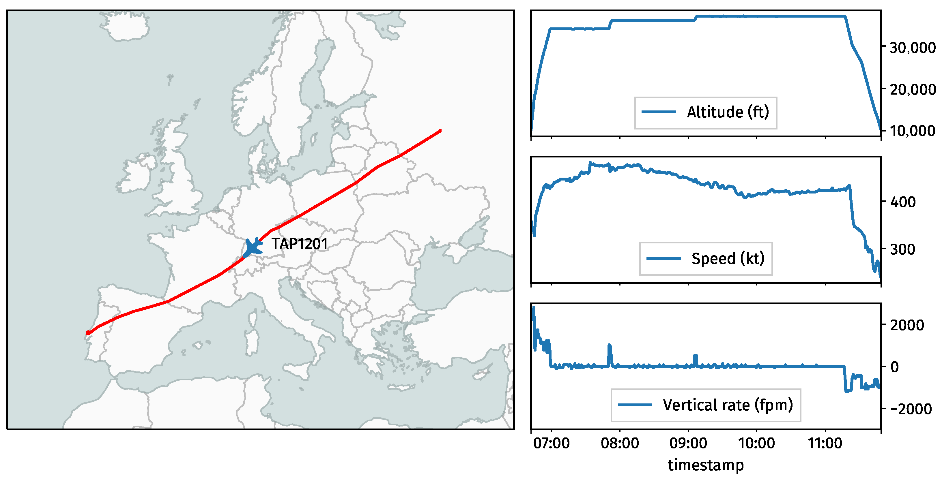
In order to post-process the downloaded state vector data, we make use of the traffic library [9], specifically to re-sample and construct flight trajectories. Figure 1 shows a example flight that was collected by the OpenSky receiver network.
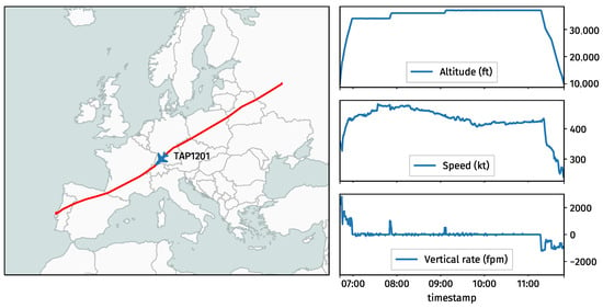
Figure 1.
An example flight trajectory including its altitude, speed, and vertical rate profiles.
Several sources of data, including the OpenSky aircraft database, Eurocontrol R&D data archive, and a subset of FlightRadar24 data (under a data license agreement), are compared and examined to identify the most likely aircraft type of each flight based on aircraft transponder code.
2.3. Emission Estimation
The emissions of flights are calculated with OpenAP, which provides the necessary aircraft performance and emission models to support estimation. Different gas emission types for each flight were presented by OpenAP, including CO2, H2O, NOx, SOx, CO, and HC.
OpenAP currently defines aircraft performance and emission models for more than 30 of the most common aircraft typecodes. It also makes use of synonyms to approximate the models for an additional set of more than 20 less common aircraft typecodes.
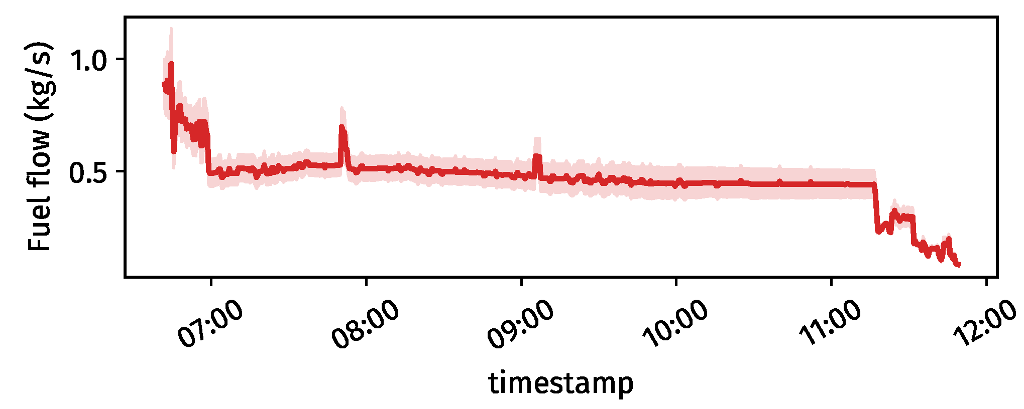
The calculation of fuel flow and emissions relies not only on flight trajectory data but also requires knowledge of aircraft mass. Aircraft mass data are not publicly available, but it is one of the parameters that greatly influences performance calculation. In order to handle unknown aircraft mass, we calculated four different emissions based on four assumptions of mass for each flight. These masses are defined at 60%, 70%, 80%, and 90% of the aircraft’s maximum take-off weight. Figure 2 shows the estimated fuel from the previous example trajectory, as well as the uncertainty boundaries caused by unknown aircraft mass.
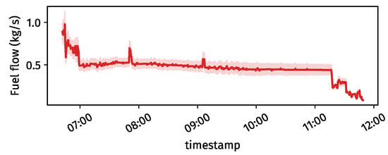
Figure 2.
Estimated fuel flow and its uncertainties along the flight.
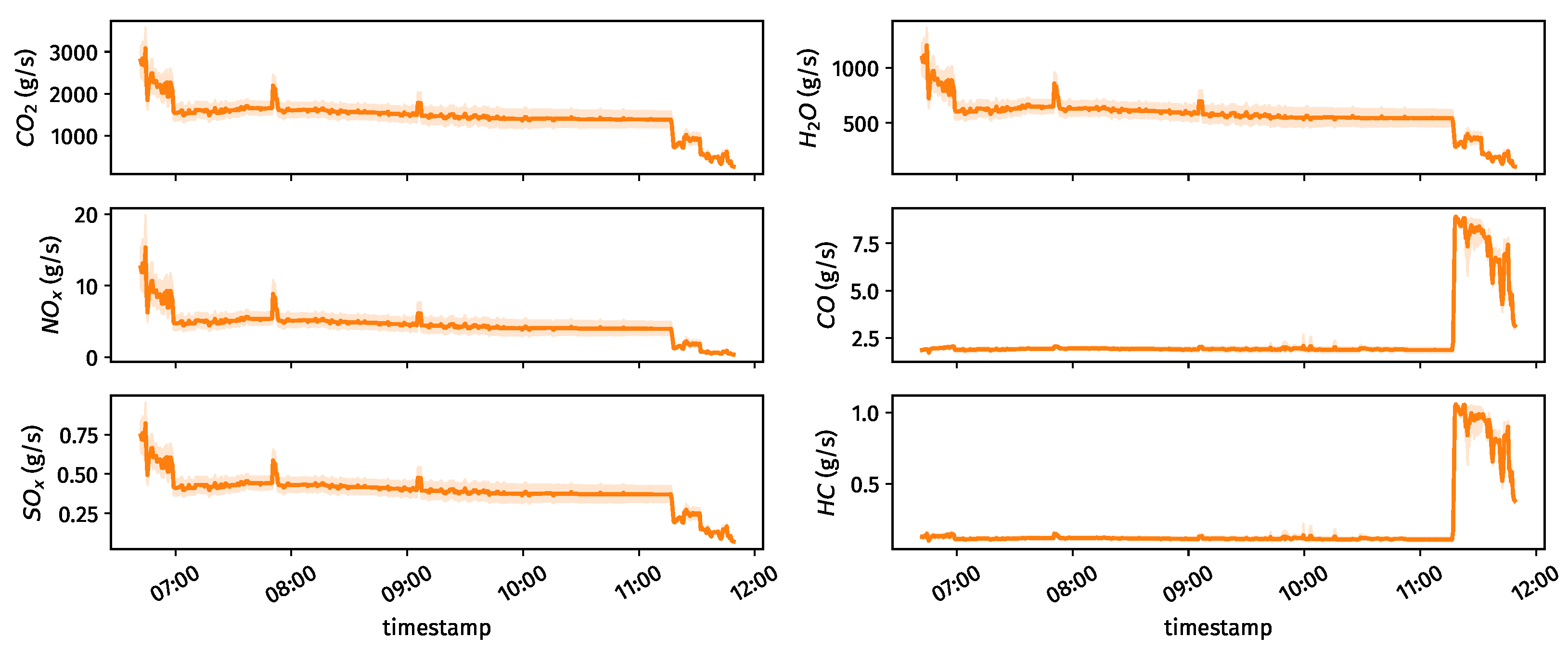
Base on the fuel flow and additional emission models from OpenAP, other types of emissions for the same trajectory are calculated. The examples of these emissions and their uncertainties are shown in Figure 3.
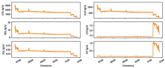
Figure 3.
Estimations of different emission types along the flight.
2.4. Emission Aggregation
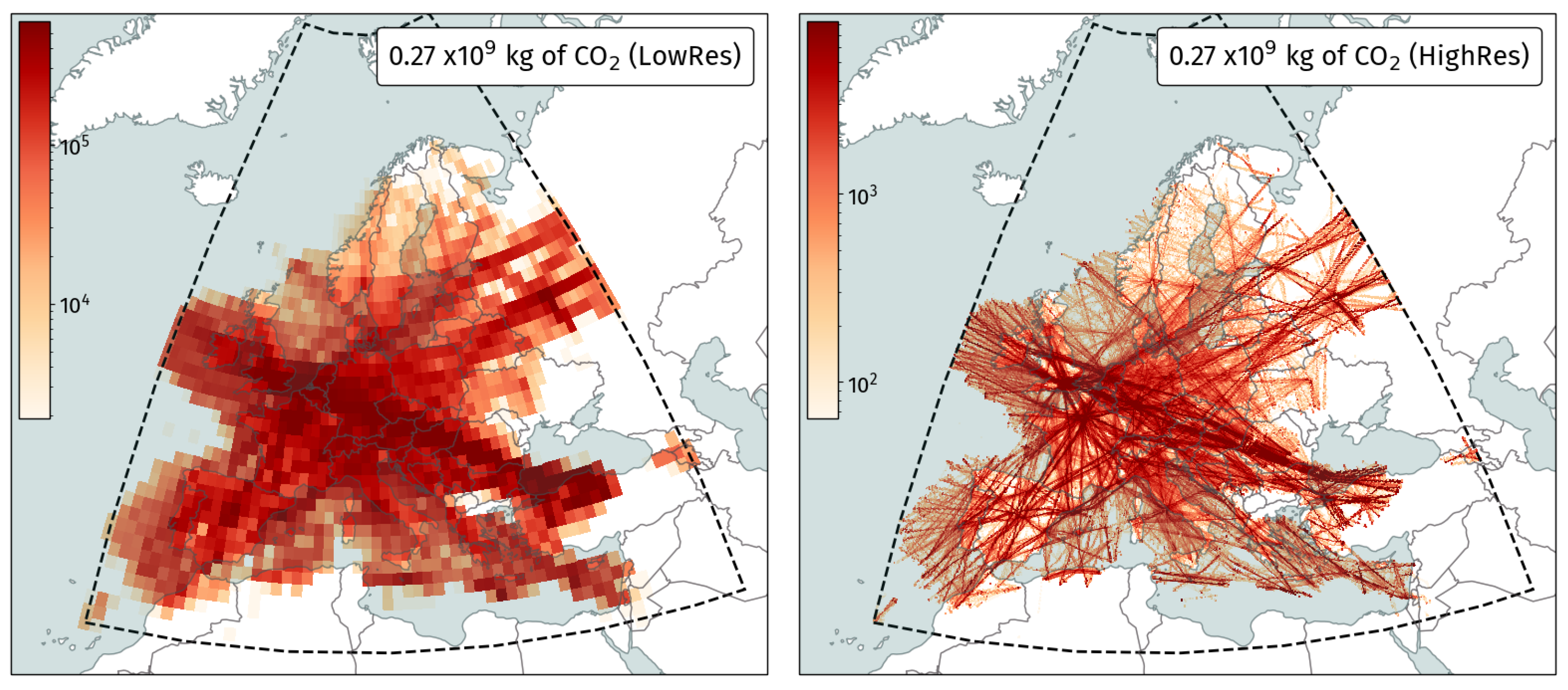
Since emissions are calculated at each trajectory level and labeled with different attributes, it is convenient to aggregate the results according to these features. First of all, we can visualize emission at different spatial resolutions. The two plots in Figure 4 illustrate one day of CO2 emission at 1-degree and 0.1-degree grids over Europe.
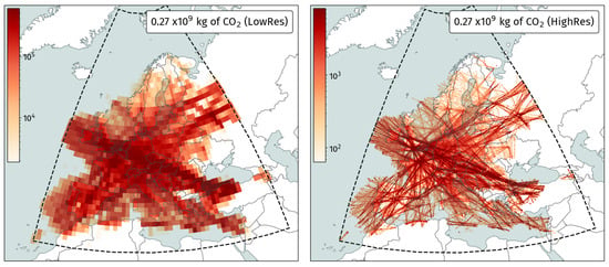
Figure 4.
CO2 emissions aggregated at different resolutions (1 January 2020).
In the Results section of this paper, we also aggregated emission results according to airlines, flight information regions, and different flight levels. Weekly changes are also obtained and shown based on the emissions estimated from individual flights.
2.5. Environmental Cost Estimation
Previous work [6] has related aviation emissions to the societal cost of its resulting climate and air quality impacts. These costs, provided on a per emission species basis, are reassigned per flight phase per regional location of the emission, and they are accompanied by corresponding uncertainty distributions. In this study, we apply these marginal cost estimates on the aggregated emissions for the EU domain, reflecting both air quality and climate externalities associated with these emissions. Specifically, we use uncertainty distributions provided by a set of Monte Carlo simulations by [6] to capture the uncertainties involved with these estimates, assuming a 3% discount rate.
Table 1 lists the range of cost estimates in 2015 USD per tonne of each emission species. A negative cost value indicates societal benefit. For example, SOx adversely impacts air quality but has a cooling effect on the climate.

Table 1.
Aggregated marginal climate cost and air quality cost due for cruise-level emissions based on Monte Carlo simulations for the EU domain from [6] used in this study.
We combine the previous aggregated emission results with these environmental costs to estimate societal externalities associated with these emissions. Uncertainties in the cost models are also calculated and reflected in the results.
3. Analysis
The analysis of this paper focuses on aggregating, illustrating, and understanding emission results from a large number of individual flights. It includes overall emissions over Europe, statistics for flight information regions, distribution of emissions at different flight altitudes, and changes in aviation emissions at the start of the COVID-19 pandemic.
3.1. Average Daily Emissions
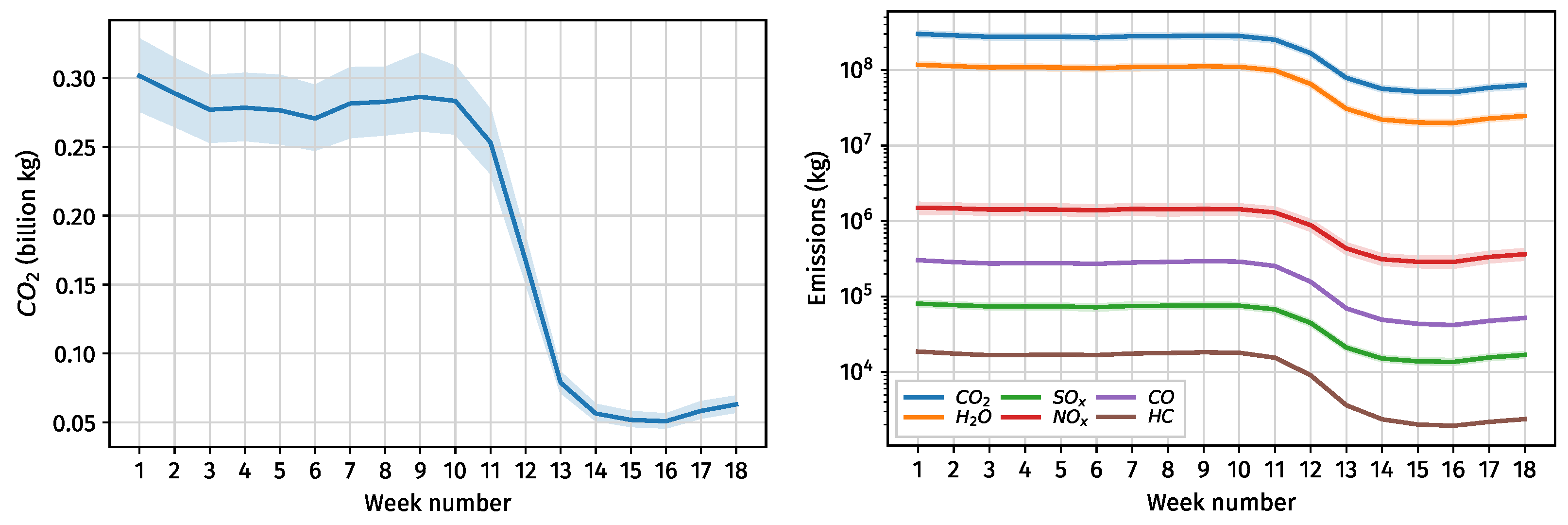
First of all, we calculated the average daily CO2 emission per week for the first four months of 2020 and illustrate the results in Figure 5.
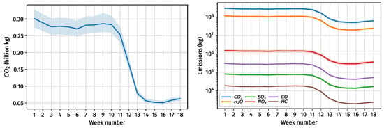
Figure 5.
Average daily emissions by week in Europe, January to April 2020.
On average, the total daily CO2 emissions was between 0.25 and 0.3 billion kg at the start of 2020, considering uncertainties and variations, with a steep decline to around 0.05 billion kg in April. Similar trends can be found for all other types of emissions, as shown on the right-hand side of Figure 5.
3.2. Climate and Air Quality Cost
Based on different types of emissions, the aforementioned global environmental costs, including climate costs and air quality costs, are calculated and shown in Figure 6. We obtain the uncertainty in the cost by cost value samples based on Monte Carlo simulations (100,000 samples) obtained from [6]. The confidence intervals represent the standard deviations in cost estimations by using these cost samples.

Figure 6.
Average daily environmental cost (in 2015 USD) by week in Europe, January to April 2020.
We find that the air quality costs dominate, which is inline with the findings from [6], but the two costs deviate further as we do not capture the contrail associated costs here, which form a large part of climate costs. This is in part also driven by focusing on the EU domain, which has been shown in previous work to have the highest global air quality impacts per unit of emission [10]. Finally, we observe wide uncertainty when translating emissions to social externalities.
3.3. Effect of COVID-19
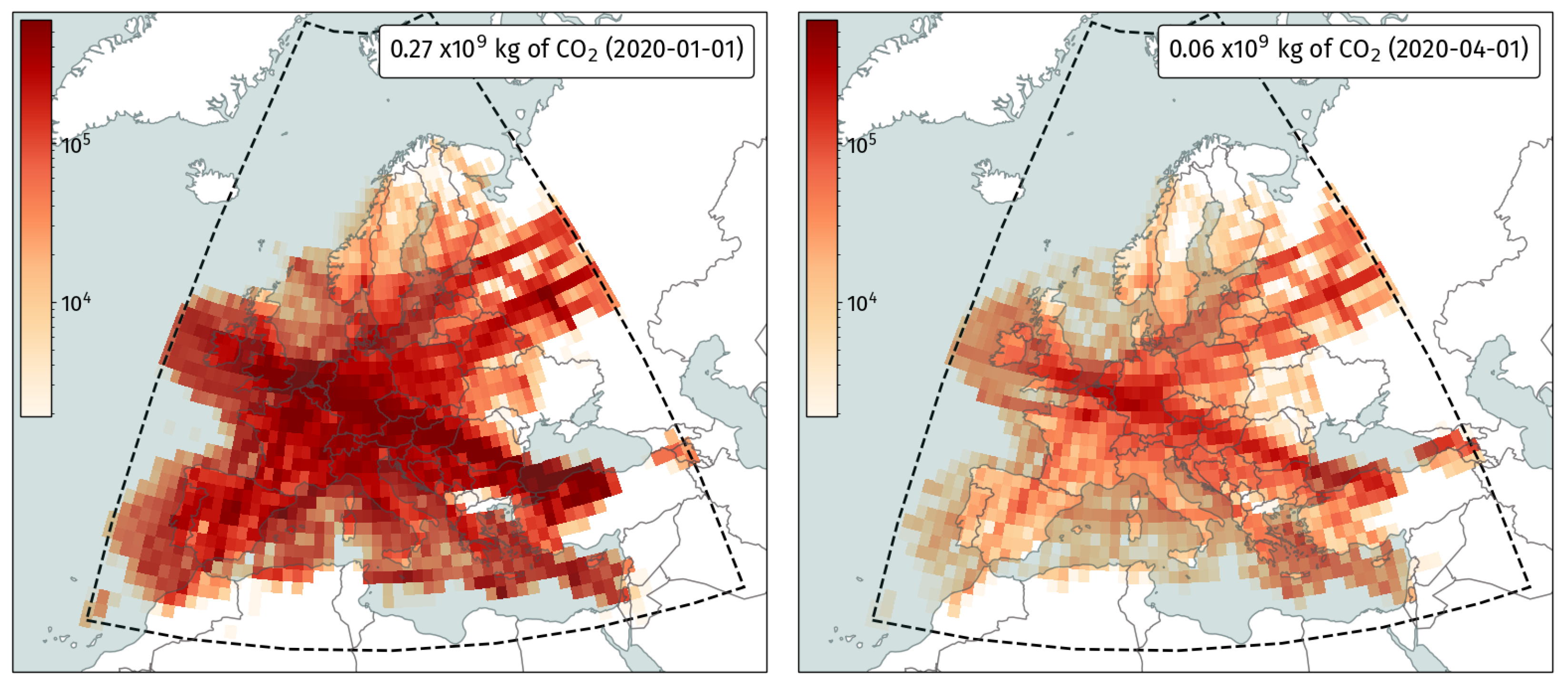
In order to further examine emissions reductions, we illustrate CO2 emissions on two different days before and at the start of the COVID-19 pandemic in Figure 7. By comparing CO2 emissions on 1 January and 1 April 2020, we find that the level of CO2 emission decreased by about 80% due to the shutdowns in aviation, which also corresponds with traffic reductions observed in [11].
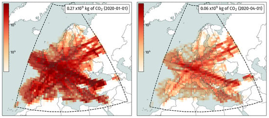
Figure 7.
CO2 before (left) and at the start (right) of the COVID-19 pandemic.
3.4. Emissions by Top Airlines
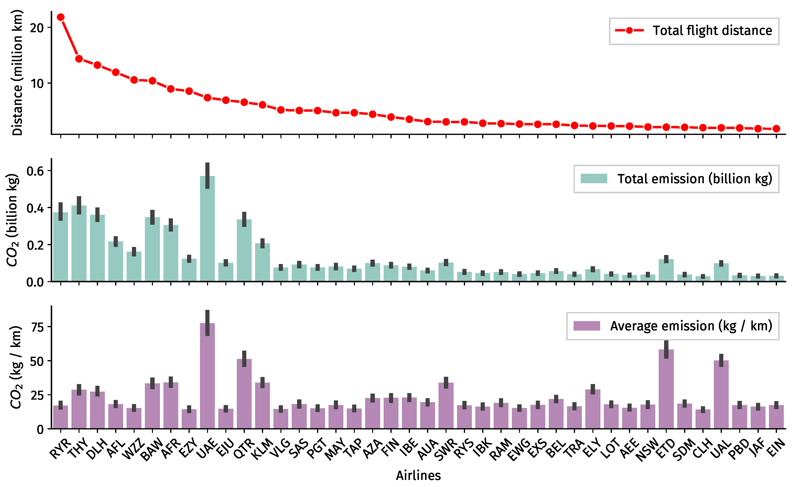
With additional information on flight operators, we can further dissect estimated emissions and link them to specific airlines. Figure 8 shows CO2 emissions from the top 40 airlines sorted by their total flown distance over Europe during January 2020. The second and third plots show the total emissions and emissions per kilometer flown. It is worth noting that this figure does not directly reflect fuel efficiency of the airline due to the size of the aircraft in their fleets.
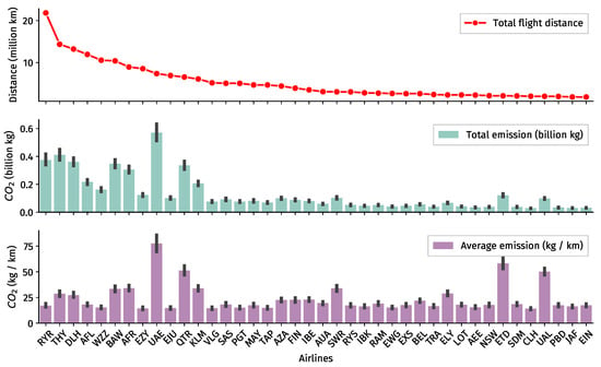
Figure 8.
CO2 emissions, in million kg, for top 40 airlines (January 2020).
3.5. Emissions per Flight Information Regions
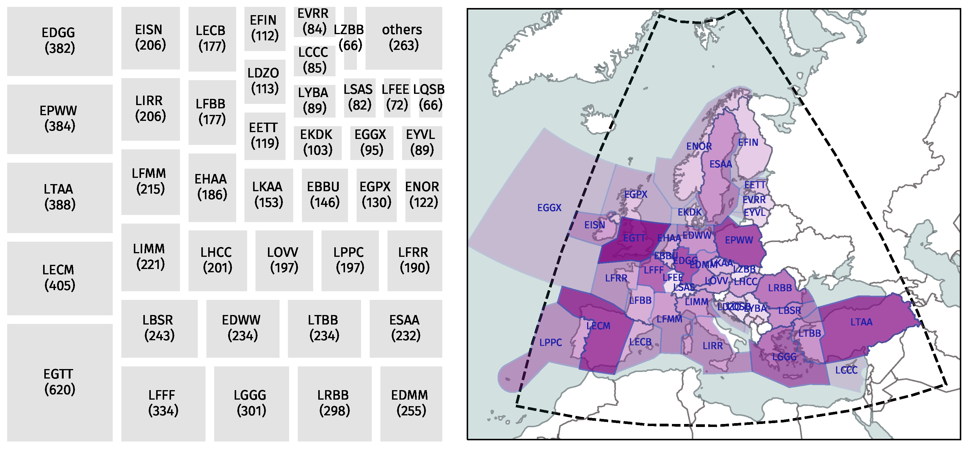
Based on the position from the sampled trajectory (every 30 s), we can construct emission statistics categorized by different flight information (FIR) regions, which are part of or affiliated with EUROCONTROL. On the left-hand side of Figure 9, total CO2 emission (in million kg) in January 2020 for each FIR was qualified. On the right-hand side of the Figure, emissions results are illustrated. The quantity difference is reflected by the changes in shades of colors.
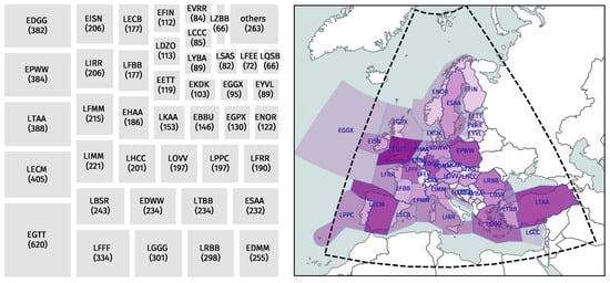
Figure 9.
CO2 emission, in million kg, by flight information regions of EUROCONTROL (January 2020).
3.6. Emissions by Flight Level
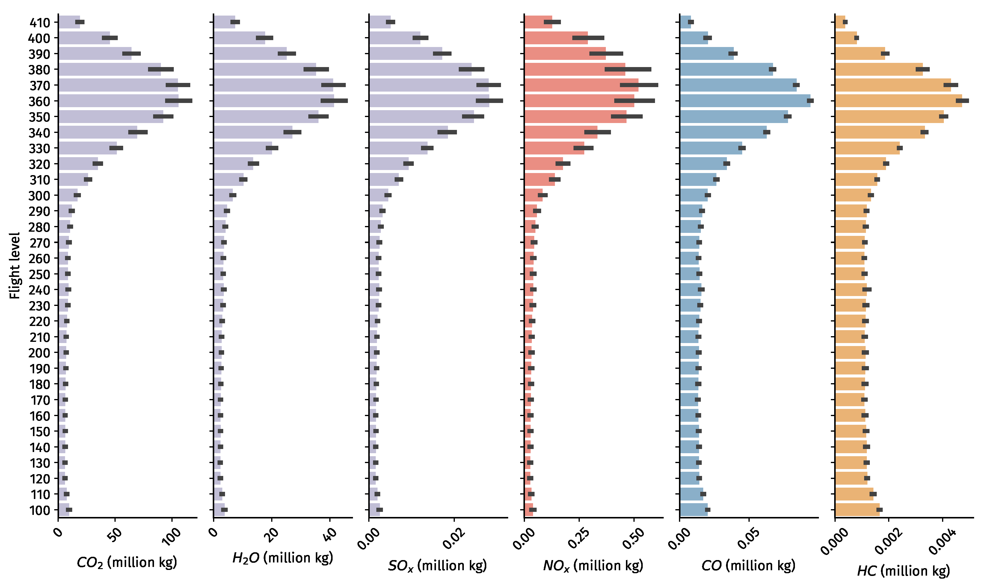
The majority of the aviation emissions are produced during the cruise altitude and flights cruise at different altitudes depending on aircraft performance and flight mission types. In the analysis, we further analyze the emissions at all different flight levels that are above FL100 for all of January 2020.
In Figure 10, all types of emissions at each flight level are shown. Among all six types of emissions, CO2, H2O, and SOx are linearly related to fuel consumption. Hence, they show the same distribution at different magnitudes. The nonlinearity is more clear for CO and HC, where higher percentages of emissions are observed at low altitudes. This is related to the fact that, at these flight phases, engines generally operate at lower thrusts. For NOx, on the contrary, slightly more emissions are produced at higher altitudes, where the engines’ operating temperatures are higher.
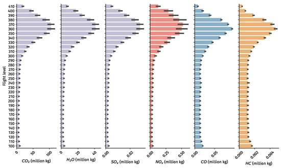
Figure 10.
Different emissions, in million kg, by flight level (January 2020).
4. Discussion and Limitations
4.1. Data Availability
We make use of OpenSky data to estimate aviation emissions. It is worth emphasizing that the accuracy of estimation is dependent on the coverage of OpenSky receivers. The results are likely to be more accurate for areas such as Europe, where receiver coverage is generally complete. However, this is not always applicable to other regions. Future studies applying this same approach to other regions must consider such limitations.
We also selected flight data over the altitude of 10,000 feet for two reasons. The first reason is linked to data availability for lower altitudes, where coverage in OpenSky is lower than that for cruise flights. On the other hand, since the majority of the flight emissions are generated during the cruise phase, we can choose to focus on this part of the flight in this study. However, we must point out the potential lower estimations for ignoring all flight emissions below 10,000 feet. Such emissions have a disproportional impact on air quality costs.
Flight data are also pre-filtered based on aircraft typecodes that are supported by OpenAP, which include around 50 of the most commonly flown aircraft typecodes. For example, most of the flights from general aviation and private jets are not part of the analysis. By inspecting on a day of around 20,000 flights, the excluded flights account for around 6% of all traffic downloaded from OpenSky. In other words, OpenAP supports emission calculation for around 94% of flights in European airspaces.
4.2. Uncertainty in Fuel Flow Estimation
There are generally three main types of uncertainties in large-scale emission estimations, which include aircraft performance uncertainty (like mass), trajectory uncertainty, and fuel flow uncertainty. The last uncertainty is not addressed in this paper, and such uncertainties and inaccuracies do exist in OpenAP [4]. It is also worth noting that only one default engine type is assumed for each aircraft type, which further contributes to overall fuel flow uncertainty.
4.3. Environmental Cost Estimation
In this study, we estimated the societal cost associated with global warming impact and degradation of air quality attributable to aviation emissions. The results are calculated using models proposed by [6]. There are large uncertainties in the estimated cost illustrated in Figure 6 driven by the increasingly large uncertainties introduced in the modeling chain from emissions and atmospheric impacts to the monetization of climate and human health impacts over different timelines.
We use marginal estimates provided for cruise-level emissions and specifically over the EU for air quality impacts, assuming a discount rate of 3%. For climate estimates, these represent globally averaged values. As previously mentioned, these estimates are best suited for estimating the impacts of marginal emissions perturbations. When we applied them to the aggregate emissions over Europe, it could result in an overestimation of the associated cost.
These marginal cost estimates are derived for marginal changes in emissions and differ from the average cost of emissions. In other words, by applying them here on total emissions quantities over the EU, we did not account for any atmospheric and other non-linearities. The authors of [6] report that these can vary by a factor of two approximately.
Finally, we did not account for contrails as well as the impacts of BC, OC, and VOC emissions, as these latter emissions are not yet included in OpenAP. However, in total, they are responsible for 17% of aviation’s societal costs.
5. Conclusions
In this paper, we proposed a bottom-up approach for estimating aviation emissions using open data and open models. Four months of flight trajectories over Europe from the OpenSky Network historical database were used to conduct this study. With an open aircraft performance and emission model, OpenAP, we performed estimations of emissions for almost all commercial flights, accounting for around 96% of flights in the dataset obtained from OpenSky. We evaluated processing time required for estimating emissions, which is approximately 30 min for computing flights during one day of all European operations (pre-COVID-19), with a single regular desktop computer. This indicates that this approach is promising for providing near-real-time estimates and monitoring of aircraft emissions.
The statistics in this paper were centered around overall CO2 and other types of emissions during the beginning of the COVID-19 pandemic. We also provided aggregated emission statistics per airline, flight information regions, and flight levels.
Based on the aggregated emission results, we found that, on average, between 0.25 and 0.30 billion kg of CO2 was emitted daily over Europe before COVID-19 in 2020. We further estimated the environmental cost of such emissions based on related global warming and air quality degradation. The combined cost is estimated to be around 70 million USD (in 2015 value) every day for the European region, which is mostly driven by air quality impacts.
Overall, our results have shown clear viability of adopting such bottom-up methods to provide detailed aviation emission analyses at different resolutions and with different perspectives.
Author Contributions
J.S.: Conceptualization, methodology, software, resource, data curation, visualization, writing—original draft, and writing—review and editing. I.D.: Conceptualization, methodology, and writing—review and editing. All authors have read and agreed to the published version of the manuscript.
Institutional Review Board Statement
Not applicable.
Informed Consent Statement
Not applicable.
Data Availability Statement
Research data is obtained and freely available from OpenSky Network historical database (https://opensky-network.org/data/impala).
Conflicts of Interest
The authors declare no conflict of interest.
References
- Olsen, S.; Wuebbles, D.; Owen, B. Comparison of global 3-D aviation emissions datasets. Atmos. Chem. Phys. 2013, 13, 429–441. [Google Scholar] [CrossRef] [Green Version]
- Kim, B.Y.; Fleming, G.G.; Lee, J.J.; Waitz, I.A.; Clarke, J.P.; Balasubramanian, S.; Malwitz, A.; Klima, K.; Locke, M.; Holsclaw, C.A.; et al. System for assessing Aviation’s Global Emissions (SAGE), Part 1: Model description and inventory results. Transp. Res. Part D Transp. Environ. 2007, 12, 325–346. [Google Scholar] [CrossRef]
- Simone, N.W.; Stettler, M.E.; Barrett, S.R. Rapid estimation of global civil aviation emissions with uncertainty quantification. Transp. Res. Part D Transp. Environ. 2013, 25, 33–41. [Google Scholar] [CrossRef]
- Sun, J.; Hoekstra, J.M.; Ellerbroek, J. OpenAP: An open-source aircraft performance model for air transportation studies and simulations. Aerospace 2020, 7, 104. [Google Scholar] [CrossRef]
- International Civil Aviation Organization (ICAO). Aircraft Engine Emissions Databank; ICAO: Montreal, QC, Canada, 2020. [Google Scholar]
- Grobler, C.; Wolfe, P.J.; Dasadhikari, K.; Dedoussi, I.C.; Allroggen, F.; Speth, R.L.; Eastham, S.D.; Agarwal, A.; Staples, M.D.; Sabnis, J.; et al. Marginal climate and air quality costs of aviation emissions. Environ. Res. Lett. 2019, 14, 114031. [Google Scholar] [CrossRef]
- Schäfer, M.; Strohmeier, M.; Lenders, V.; Martinovic, I.; Wilhelm, M. Bringing up OpenSky: A large-scale ADS-B sensor network for research. In Proceedings of the 13th International Symposium on Information Processing in Sensor Networks, Berlin, Germany, 15–17 April 2014; pp. 83–94. [Google Scholar]
- Sun, J.; Hoekstra, J. Integrating pyModeS and OpenSky Historical Database. In Proceedings of the 7th OpenSky Workshop 2019, Zurich, Switzerland, 21–22 November 2019; Volume 67. [Google Scholar]
- Olive, X. Traffic, a toolbox for processing and analysing air traffic data. J. Open Source Softw. 2019, 4, 1518. [Google Scholar] [CrossRef] [Green Version]
- Quadros, F.D.; Snellen, M.; Dedoussi, I.C. Regional sensitivities of air quality and human health impacts to aviation emissions. Environ. Res. Lett. 2020, 15, 105013. [Google Scholar] [CrossRef]
- Strohmeier, M.; Olive, X.; Lübbe, J.; Schäfer, M.; Lenders, V. Crowdsourced Air Traffic Data from the OpenSky Network 2019–20. Earth Syst. Sci. Data Discuss. 2020, 2020, 1–15. [Google Scholar]
Publisher’s Note: MDPI stays neutral with regard to jurisdictional claims in published maps and institutional affiliations. |
© 2021 by the authors. Licensee MDPI, Basel, Switzerland. This article is an open access article distributed under the terms and conditions of the Creative Commons Attribution (CC BY) license (https://creativecommons.org/licenses/by/4.0/).

