1. Introduction
Terrestrial and Satellite-based navigation techniques have fulfilled one of the major needs of human beings, i.e., navigation. With the
emergence of sensor-based techniques, many methods have evolved for terrestrial-based
location finding as well as navigation using a set of sensors such as radio-frequency
identification (RFID), wireless sensor networks, cellular networks, wireless local
area networks (LANs), and many others. Similarly, the world witnessed the launch
of Sputnik and Explorer series of satellites in the late 1950s by the USSR and the
USA, respectively. The space endeavor led to the conceptualization and completion
of TRANSIT and TSYKLON regional satellite-based navigation systems primarily meeting
the requirements of that era, for the USA and USSR, respectively. Today there are
three completely operational satellite-based navigation systems and few regional
navigations systems such as Indian Regional Navigation Satellite System (IRNSS)
(operationally known as “NavIC”: Navigation with Indian Constellation) and Quasi-Zenith
Satellite System (QZSS). Initially, the two methods of navigation i.e., terrestrial
and satellite-based navigation systems have been treated separately. However, in
the last three decades and especially in recent times due to development in electronics
and computers, the two techniques are coming together to provide the solution for
positioning, navigation, and timing (PNT). Here in this review the terrestrial techniques,
which can be operated over large ranges alongside the traditional techniques, are
considered, and those that are under implementation and testing for joint utilization
along with satellite-based navigation techniques reported. Some of the other traditional
techniques for navigational requirements through mapping primarily include various
traversing techniques utilizing instruments like a plane table, compass, sextant,
theodolite, tacheometer, or the total station used in surveying, RFID and cellular
tower methods.
Spencer et al. (2003) discuss the features and operational
requirements of GPS in a detailed manner [
1]. In
addition, the positioning systems in wireless sensor networks, and cellular networks,
wireless LANs are discussed by Dardari et al. [
2].
LORAN-C and Chayka are the terrestrial-based navigation systems which were developed
by the USA and the USSR, respectively [
3,
4]. The
University of Rostock has started early experimentations for increasing their accuracy,
availability, and reliability using integrated solutions with (D)GPS/(D)
Globalnaya navigatsionnaya sputnikovaya sistema (GLObal NAvigation Satellite
System (GLONASS) or their combination with LORAN-C for identification of the dynamics
of ships. Support using LORAN-C or Chayka appeared to be correct regarding the uncertainties
of global navigation satellite systems (GNSS) against jamming in the study [
5]. The presented review paper assesses the utility
of these systems for users with a special preference for navigation, and remote
sensing and geographical information systems (RS&GIS) based applications.
2. Materials and Methods
An extensive literature review was conducted on the
important topic of navigation. Mostly terrestrial and satellite-based navigation
techniques have been investigated operating over continental scales and at local-level,
and are especially useful in the area of navigation, RS&GIS, or web-based applications. A large number of published
papers, reports, standard books, and authentic web-content were utilized in the
study besides experience in the area of GNSS specifically. The key systems and methods
are then presented in the following sections along with the challenges in combining
the two technologies with the available solution currently for the user.
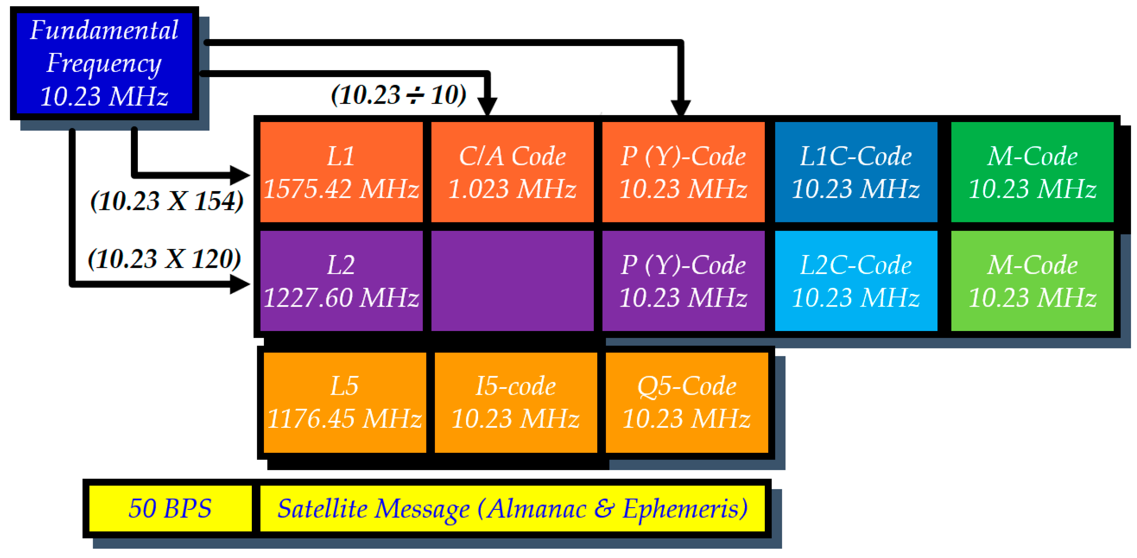
Figure 1 shows
the basic design of NAVigation
Satellite Timing And Ranging Global Positioning System (NAVSTAR GPS) describing
the carrier waves (L1, L2, L5), codes (C/A, P(Y), L1C, L2C, M, I5, Q5) and satellite
messages with Almanac information as well as ephemeris used for PNT services. These
codes and carrier waves are used for the computation of pseudoranges and fixing
the location of the receiver.
3. Satellite Navigation Systems
Currently, three global satellite-based navigation systems
namely, NAVSTAR GPS of the USA, GLONASS of Russia, and BEIDOU of China, are providing
PNT services with full functionality. The fourth system GALILEO is being developed
by the EU and is expected to be completed by 2020 [
6].
These systems use geostationary orbits (GSO), inclined Geosynchronous orbits (IGSO),
and Medium earth orbits (MEO) for the satellites in the constellations (
Table 1).
3.1. Global Satellite-Based Navigation Systems
Table 1 provides the details of the major characteristics and features of the four GNSS systems. These satellite-based navigation systems are mainly working on one-way ranging principles. These systems use the trilateration technique among methods of surveying to compute the location of the receiver using pseudo-range equations for a minimum of four of satellites through a code or phase-based solution. Signals from more or redundant satellites enable the attainment of high accuracy by reducing the errors using the least square adjustment method in the computation of location coordinates. GNSS provides standard positioning services (SPS) and precise positioning services (PPS) or high precision services (HPS) through encryption for authorized users. GALILEO is planned to provide more services on becoming fully operational, such as open services (OS), search and rescue (SAR), public regulated services (PRS), commercial services (CS), and Safety of Life (SoL) [
7]. These systems are extensively useful in RS&GIS for mapping and resource management applications [
8,
9,
10,
11]. The Chinese BEIDOU system is the latest addition to GNSS and is also under extensive use now, as its constellation was recently completed in 2020. BEIDOU has formed an International GNSS Monitoring and Assessment Service (iGMAS) and provides code division multiple access (CDMA) signals for compatibility with existing the systems of NAVSTAR GPS and GLONASS. A figure of merit called Geometric Dilution of Precision (GDOP) is utilized in GNSS to signify the quality of signals and associated uncertainty, which largely depends on the geometry of the available satellites from which the receiver is receiving the signals.
3.2. Regional Satellite-Based Navigation Systems
IRNSS and QZSS are the two regional operational satellite-based navigation systems belonging to India and Japan, respectively. IRNSS/NavIC provides precise and accurate PNT services over the Indian region and up to 1500 km beyond the Indian boundaries. Regional systems also provide standard positioning services (SPS) and precise positioning services (PPS) through restricted services (RS) for authorized users which are encrypted [
12]. Regional satellite-based navigation systems are also extremely useful in RS&GIS applications [
13,
14]. In a study by Dey et al. (2020) on IRNSS signals, the diurnal variation of the position error indicated a maximum during afternoon hours, coinciding with the time of maximum total electron content (TEC) over the equatorial ionization anomaly (EIA) crest region [
15].
4. Terrestrial Navigation Systems
Global and regional terrestrial (tower)-based navigation techniques were developed initially by various agencies of developed countries. These radio navigation systems require a technically complex design of a large set of tall antennas and costly infrastructure for continental or global-scale solutions for the shipping industry especially. All radio navigation systems, depend on measuring or inferring by some means the distance from a known location to the craft’s (or receiver’s) current position [
16].
4.1. Global Terrestrial-Based Navigation Systems
The global terrestrial (tower)-based navigation techniques include Alpha developed by the USSR [
17] and Omega developed by the USA [
18]. Alpha is also known as RSDN-20 in the Russian language and after translation in English, it means “radio-technical long-distance navigation system”. These systems operate at very low frequency (VLF) ranges as per the International Telecommunication Union (ITU) designation for radio frequencies (RF) and provide PNT solutions to respective users with almost global coverage. Omega uses the intersection of Line of Positions (LOPs) using range–range (or rho–rho) or range–range–range measurements to determine the position of the receiver. Preferably a minimum of three or more independent range measurements and LOPs can be used (referred to as a multilateration or multiranging navigation) for providing higher accuracy using basic principles of surveying. In general, the requirement is to measure the time it takes for a radio signal to propagate over the desired distance to infer the distances with the signal phase as the fundamental measurement necessitating the corrections for phase during the travel between the transmitter(s) and receiver(s). A figure of merit called Geometric Dilution of Precision (GDOP), is computed as the ratio of position error divided by range measurement error, to give a measure for quality of solution [
16].
4.2. Regional Terrestrial-Based Navigation Systems
A long-range navigation system, also known as Loran-A (or “Standard LORAN”) is a hyperbolic radio navigation system developed in the United States and used extensively for the navigation of ships as well as aircraft. The United Kingdon (UK) also has a Gee system, which is operated at lower frequencies to provide an improved range up to 1500 miles. LORAN used the multilateration principle to determine position using a receiver by computations based on the time difference of arrival (TDOA) difference in the signals from the master and slave stations.
Similarly, USA developed Loran-B, which offered accuracy of the order of a few tens of feet [
3]. Loran-C has been a more successful system and integration is being attempted into the solution of PNT services along with satellite-based navigation systems. Loran transmitter antennas are vertical towers approximately 200 m high to provide vertical polarization. The phase center of the antennas is maintained within about 1 m from the published positions. The excellent stability of the enhanced Loran (eLoran) system yields repeatable accuracies of 20–50 m [
19]. Furthermore, the enhanced Differential Loran (eDLoran) provides an accuracy improved to an order of 10 m [
4,
19,
20,
21]. Locata is another terrestrial PNT technology providing PNT services at the local service level using a constellation of master and slave sets of a LocataLite setup [
22].
5. Eurofix: Combined Use of Terrestrial and Satellite-Based Navigation Techniques
Delft University initially proposed the Eurofix concept in 1989 for a PNT solution by combining GNSS and LORAN/Chayka [
23]. Eurofix has a large potential for improving the PNT solution over continental areas and can become an alternative ground-based solution to the satellite-based augmentation systems (SBAS) such as the Wide Area Augmentation System (WAAS) in the USA or the European Global Navigation Overlay System (EGNOS) in the EU [
24]. Reelektronika has developed a powerful alternative PNT solution for an Integrated GNSS eLoran/Chayka called the Loradd++, providing it with very a small size chip (60 × 30 × 8 mm) with a Dual-channel receiver and low power < 500 mW (3.3 V) requirements.
6. Major Challenges in the Existing Methods
The terrestrial and satellite-based navigation techniques have their own set of advantages and disadvantages. The terrestrial based navigation techniques largely depend on the ground network of towers for communications, wherein the line of sight, distribution, as well as density of towers along with factors influencing the attenuation of signals, are some of the major constraints with heavy–tall as well as costly infrastructure. In the case of satellite-based navigation techniques the major constraint is in covered areas such as dense forest canopy regions, and tunnels, or underground regions, where local solutions can be better such as LAN or RFID providing indoor location tracking systems [
25]. Thus, it is required to combine the two techniques and provide a more robust system overcoming the constraints of the existing terrestrial and satellite-based navigation systems.
7. Conclusions
Civilian and authorized users are using terrestrial and Satellite-based navigation techniques extensively. The number of applications built on the navigations services is increasing perpetually due to the technological advances and easy availability of the internet with internet-based mobile platforms with various domain-specific (land/ocean/air/space) applications. The literature review shows that the regional satellite-based navigation systems like IRNSS and QZSS provide accuracies comparable to GNSS in their primary service region. The study shows that there is a large potential for the combined navigation solutions from terrestrial and Satellite-based navigation systems. Further integration of these systems with local solutions like RFID or LAN will assist in uninterrupted PNT services in indoor as well as open environments.
Funding
This research received no external funding.
Acknowledgments
The author would like to send words of appreciation to the international and national space agencies as well as telecommunication agencies like International Telecommunication Union (ITU), Indian Space Research Organisation (ISRO), Japan Aerospace Exploration Agency (JAXA), National Aeronautics and Space Administration (NASA), Russian Federal Space Agency (Roscosmos), European Space Agency (ESA), China National Space Administration (CNSA) along with their collaborators for their insights and support to the GNSS or terrestrial navigation systems or both. Their support is highly valuable for users and in the presented study, helping the entire scientific fraternity at large as well as the commercial consumers or authorized users. The author is highly indebted to the Director of the IIRS for the continual support and encouragement for conducting the research activities.
Conflicts of Interest
The author declares no conflict of interest.
References
- Spencer, J.; Frizzelle, B.G.; Page, P.H.; Vogler, J.B. Global Positioning System; Blackwell Publishing Ltd.: Oxford, UK, 2003. [Google Scholar]
- Dardari, D.; Luise, M.; Falletti, E. Satellite and Terrestrial Radio Positioning Techniques; Elsevier Ltd.: Oxford, UK, 2012. [Google Scholar]
- LORAN. Available online: https://en.wikipedia.org/wiki/LORAN (accessed on 12 October 2020).
- CHAYKA. Available online: https://en.wikipedia.org/wiki/CHAYKA (accessed on 14 October 2020).
- Gluch, M.; Kirchner, J.; Herzig, M. Development of Software Structure for Integrated Navigation Receivers in Shipping. IFAC Proc. 2000, 33, 407–412. [Google Scholar] [CrossRef]
- FAQ. Available online: https://www.gsa.europa.eu/european-gnss/galileo/faq (accessed on 12 October 2020).
- Samama, N. Global Positioning: Technologies and Performance; John Wiley & Sons: Hoboken, NJ, USA, 2008. [Google Scholar]
- Lillesand, T.M.; Kiefer, R.W.; Chipman, J.W. Remote Sensing and Image Interpretation; Wiley: Hoboken, NJ USA, 2014. [Google Scholar]
- Wolf, P.R.; Dewitt, B.A. Elements of Photogrammetry: With Applications in GIS; McGraw-Hill: New York, NY USA, 2000. [Google Scholar]
- Bhardwaj, A. Evaluation of DEM, orthoimage generated from Cartosat-1 with its potential for feature extraction and visualization. Am. J. Remote Sens. 2013, 1, 1–6. [Google Scholar] [CrossRef]
- Bhardwaj, A.; Jain, K.; Chatterjee, R.S. Generation of high-quality digital elevation models by assimilation of remote sensing-based DEMs. J. Appl. Remote Sens. 2019, 13, 1. [Google Scholar] [CrossRef]
- Irnss-Programme. Available online: https://www.isro.gov.in/irnss-programme (accessed on 11 October 2020).
- Srivastav, S.K.; Kumar, A.; Pandey, K.; Mahadevaswamy, M.; Oberai, K.; Verma, P.A.; Barange, S.; Gangwal, N.; Bhardwaj, A.; Kumar, A.S.; et al. Evaluation of GAGAN and IRNSS Data in Himalayan Terrain. In Second GNSS User Meet; ISAC, ISRO: Bangaluru, India, 2015; pp. 32–33. [Google Scholar]
- Pandey, K.; Srivastav, S.K.; Bhardwaj, A. Assessment of the Quality of GAGAN and IRNSS or ‘NAVIC’ data for use in social applications. In Role of Space Science for Social Welfare/applications; IIRS, ISRO: Dehradun, India, 2016; pp. 26–33. [Google Scholar]
- Dey, A.; Joshi, L.M.; Chhibba, R.; Sharma, N. A study of Ionospheric effects on IRNSS/NavIC positioning at equatorial latitudes. Adv. Space Res. 2020. [Google Scholar] [CrossRef]
- Morris, P.B.; Gupta, R.R.; Warren, R.S.; Creamer, P.M. Omega Navigation System Course Book (Volume I); Omega Navigation System Center, U.S. Coast Guard: Alexandria, VA, USA, 1994. [Google Scholar]
- Alpha_(Navigation). Available online: https://en.wikipedia.org/wiki/Alpha_(navigation) (accessed on 14 October 2020).
- Omega (Navigation System). Available online: https://en.wikipedia.org/wiki/Omega_(navigation_system) (accessed on 14 October 2020).
- eLoran, Eurofix & 9th Pulse. Available online: https://www.reelektronika.nl/technology/eloran-eurofix-9th-pulse/ (accessed on 12 October 2020).
- van Willigen, D.; Kellenbach, R.; Dekker, C.; van Buuren, A.W. eDLoran—Next Generation of Differential Loran. Available online: https://rntfnd.org/wp-content/uploads/eDLoran-Reelektronica-Paper.pdf (accessed on 12 October 2020).
- The Administration Global Loran/eLoran Infrastructure Evolution-A Robust and Resilient PNT Backup for GNSS. Available online: https://www.gps.gov/governance/advisory/meetings/2014-06/narins.pdf (accessed on 12 October 2020).
- Rizos, C.; Yang, L. Background and Recent Advances in the Locata Terrestrial Positioning and Timing Technology. Sensors 2019, 19, 1821. [Google Scholar] [CrossRef] [PubMed]
- Offermans, G.W.A.; Helwig, A.W.S.; van Willigen, D. Eurofix: Test results of a cost-effective DGNSS augmentation system. J. Navig. 1997, 50, 209–223. [Google Scholar] [CrossRef]
- van Willigen, D.; Offermans, G.W.A.; Helwig, A.W.S.; Breeuwer, E.J.; Helwig, A.W.S.; Breeuwer, E.J. Reprint of: New Views on the System Aspects of Eurofix the 25th Annual Technical Symposium of the International Loran Associa- New Views on the System Aspects of Eurofix. In Proceedings of the 2£th Annual Technical Symposium of the International Loran Association, San Diego, CA, USA, 3–7 November 1996; pp. 1–7. [Google Scholar]
- Chothani, A.; Saindane, J.; Mistari, H.; Bhavsar, N.; Shirsath, R. RFID-based location tracking system using a RSS and da. In Proceedings of the International Conference on Energy Systems and Applications, ICESA 2015, Pune, India, 30 October–1 November 2015; pp. 748–751. [Google Scholar]
| Publisher’s Note: MDPI stays neutral with regard to jurisdictional claims in published maps and institutional affiliations. |
© 2020 by the author. Licensee MDPI, Basel, Switzerland. This article is an open access article distributed under the terms and conditions of the Creative Commons Attribution (CC BY) license (https://creativecommons.org/licenses/by/4.0/).


