Proceeding Paper

GNSS Jamming and Its Effect on Air Traffic in Eastern Europe †

1
Centre for Aviation, School of Engineering, Zurich University of Applied Sciences, 8401 Winterthur, Switzerland
2
SkAI Data Services, 8050 Zurich, Switzerland
3
ONERA DTIS, Université de Toulouse, 2, avenue Édouard Belin, 31055 Toulouse, France
*
Author to whom correspondence should be addressed.
This paper is an extended version of our paper published in Presented at the 10th OpenSky Symposium, Delft, The Netherlands, 10–11 November 2022.
Eng. Proc. 2022, 28(1), 12; https://doi.org/10.3390/engproc2022028012
Published: 20 December 2022
(This article belongs to the Proceedings of The 10th OpenSky Symposium)

Abstract

:
Global navigation satellite systems technology is at the core of modern air traffic navigation. Aircraft use it to estimate their position, while air navigation service providers rely on services such as automatic dependent surveillance broadcast which have been enabled by this technology. Since satellite signals are very low in power, they are susceptible to radio frequency interference activities, which can have a significant impact on aviation. This paper illustrates how crowd-sourced automatic dependent surveillance data transmitted by aircraft can be used to gain situational awareness about radio frequency interference and how air traffic over Eastern Europe has been impacted by interference activities over a period spanning from February to August 2022. The results suggest that satellite navigation signals were subject to interference of varying strength and duration. We observed several days when more than 1000 flights were affected, representing 60% of the daily traffic in the analysed area. Furthermore, the extent of the interference impact on aviation depends on the altitude of the aircraft, as low-flying aircraft tend to be less affected by interference than the ones flying at higher altitudes. Consequently, this paper contributes to a better understanding of how civil aviation is affected by radio frequency interference and where such disturbances may occur.

1. Introduction

Aeronautical navigation relies heavily on the availability of Global Navigation Satellite Systems (GNSS). In almost all modern commercial aircraft, GNSS is used as the primary means of navigation for guidance on departure, en route, and also during the arrival phase of flight. Together with space- or ground-based augmentation systems (SBAS or GBAS), GNSS is even capable of providing precision approach guidance and is one of the core satellite-based technologies identified in the Global Air Navigation Plan [1] and the European Air Traffic Management Master Plan [2] for supporting future airspace evolution.
Position, navigation, and timing (PNT) information from GNSS is not only used for navigation but also for other systems in the aircraft, such as aircraft time, terrain awareness warning systems (TAWS) or ground proximity warning systems (GPWS), airborne traffic situational awareness system (ATSAW), and weather radar declutter [3]. Most notably, however, position information with integrity is required to feed to the automatic dependent surveillance broadcast (ADS-B), which is a surveillance system broadcasting aircraft position information and other parameters regularly. As GNSS is currently the only navigation system capable of providing integrity for the position solution, a loss of the former generally leads to ADS-B position reporting faults [4]. Radio frequency interference (RFI) has been known to cause loss of GNSS functionality to civil aircraft for many years now [5,6,7]. On 18 and 19 October 2022, the airspace in the Dallas area was affected by RFI, leading to the unavailability of GPS-based arrival and departure procedures [8]. In addition, RFI can occasionally be observed in the vicinity of military exercises and rather often near crisis areas (for an overview of known and documented RFI incidents, we refer to Darabseh et al. [9]). A substantial amount of GNSS-related RFI occurred in Eastern Europe following the start of the crisis in Ukraine, which led the European Union Aviation Safety Agency (EASA) to publish a safety-information bulletin [10]. In this publication, EASA outlined potential effects of GNSS-related RFI on aircraft as well as suggestions to operators to “ensure flight crews and relevant flight operation personnel are aware of possible GNSS jamming”. This requires situational awareness in near real-time about potential areas subject to RFI-related disturbances.
Even though RFI has an impact on the availability of flight procedures and thus the capacity of airspace sectors and airports, Figuet et al. [11] showed that RFI is not a direct threat for mid-air collisions as long as other means of navigation are available. Indeed, while most aircraft are well-equipped with a variety of different navigation systems, ranging from conventional navigation (such as the VHF omnidirectional range (VOR) and multiple distance measuring equipment (DME) units) to redundant high-grade inertial reference systems (IRS) for autonomous navigation, it is essential for the optimal use of airspace and advanced flying procedures that precise and reliable navigation is available throughout all phases of flight. Unfortunately, not all aircraft are well-equipped: some business jets may not have many alternatives for GNSS-based navigation and might need to rely on support from air traffic control (ATC) for radar-based guidance in case GNSS is not available. In order to adequately prepare for a flight, it is essential that dispatchers and flight crews be aware about potential loss of GNSS on the planned route so that they can revert to conventional navigation procedures and ensure safe operations at all times. For ATC, it is important to be aware of aircraft in their airspace potentially requiring extra assistance, as this has a direct impact on the workload of air traffic controllers and therefore the capacity of a sector. To this day, no common detection scheme for areas affected by RFI is operational. For situational awareness, aircraft operators as well as ATC have to rely on pilot reports from previous flights for information about potentially affected areas.
In the literature, a number of studies dealing with the (i) characterisation, (ii) detection, (iii) localisation, and (iv) simulation of RFI incidents on ADS-B signals transmitted by aircraft are mentioned. Most of these methods rely on integrity parameters transmitted in the ADS-B message. To this end, the navigation accuracy category for the position (NACp) and the navigation integrity category (NIC) give a good indication when GNSS-based navigation is lost, as both parameters decrease as a consequence.
Studies focusing on the characterisation are concerned with the question of how the NACp information transmitted via ADS-B is influenced by RFI incidents [9,12]. In this context, Pleninger et al. [6] evaluated the effect of RFI on the multi-mode receiver of a Boeing 737MAX aeroplane in stationary conditions, i.e. the source of interference and the aircraft remained stationary on the ground. Liu et al. [5] reported on flight tests investigating how stationary sources of RFI affect ADS-B signals of aircraft in flight. They further characterised the impact of known RFI events on the observed ADS-B signals of aircraft operating in the vicinity of Hayward Executive Airport in the San Francisco Bay Area.
Studies dealing with detection focus on the way RFI activities can be identified based on ADS-B information. While Osechas et al. [7] showed how RFI events can be recognised by flight crews in the cockpit of an airliner, other authors examined how RFI events influence the NACp values transmitted by aircraft via ADS-B. In this context, Darabseh et al. [9] compared the distribution of NACp values of flights affected by RFI with unaffected flights, while Lukeš et al. [12] applied pattern recognition techniques on the fluctuation of NACp values transmitted by ADS-B in the case of known RFI events. Moreover, Jonáš and Vitan [13] suggested a detection procedure that exploits the causality between RFI incidents and ADS-B trajectory gaps identified by the authors.
Studies dealing with localisation problems present approaches that enable the sources of interference to be pinpointed. For cases in which the ADS-B signal is interrupted by RFI, Jonáš and Vitan [13] applied the power difference of arrival method (see [14]), while Liu et al. [15] suggested an approach based on a convex optimisation model. For cases in which the NIC is affected by an RFI incident, mathematical models [16] and machine-learning models [17] to localise the source of interference are proposed in the literature. Finally, [16] presented a simulation tool that can be used to artificially generate ADS-B data of aircraft influenced by RFI incidents.
While methods for identification of RFI activities based on ADS-B data were previously developed and published, a systematic study of the extent, development over time, and concrete impact on air traffic in different regions has not yet been performed. In this paper, we perform a systematic evaluation of the evolution of jamming events in Eastern Europe in the year 2022. We assess the observable impact on aviation based on crowdsourced ADS-B data from the Opensky Network (OSN) [18]. For the impact analysis, we identify spatial and timely patterns of occurrence of RFI and generate statistics for the number and percentage of affected flights in a given sector.

2. Methodology

In order to study and assess the impact of RFI activities on air traffic, a methodology based on several steps is applied in this paper. In a first step, Section 2.1 illustrates how geographical zones with active RFI are identified. Subsequently, Section 2.2 describes how the data required for this paper is collected and processed. Finally, Section 2.3 shows how flights affected by RFI can be identified based on the collected data.

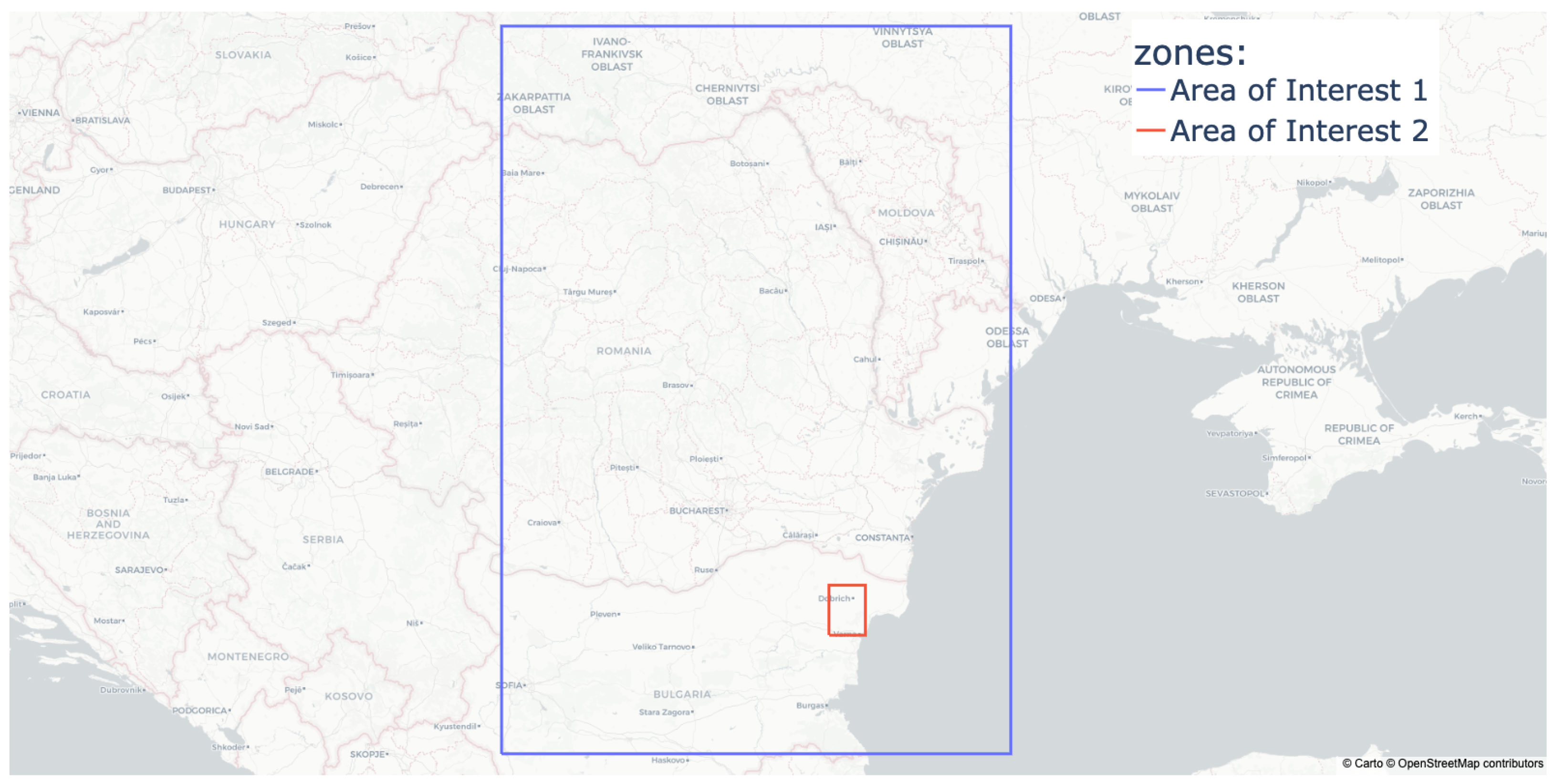
2.1. Identification of Zones of RFI

In a first step, the geographical areas in which RFI activity is pronounced are identified. To determine active zones of RFI, we consulted the web page http://www.gpsjam.org/ (accessed on 1 November 2022), provided and hosted by Wiseman [19]. This web page provides an overview of daily RFI activities based on ADS-B data. Regarding the European airspace, two areas that are frequently affected by GNSS RFI are the airspace around the Kaliningrad exclave, as well as the airspace bordering the Black Sea between Moldova, Romania, and Bulgaria. Since the area around the Black Sea appears to be the most impacted by RFI and traffic though the area has significantly increased since most of the traffic between Asia and Europe currently avoids Russian airspace, this paper focuses on a geographical area of interest (AoI) marked with a blue box in Figure 1 for a period between February 2022 and the end of August 2022. In the following, this area is referred to as AoI-1. For a more detailed analysis, as described later in this chapter, the area marked in red in Figure 1 and referred to as AoI-2 was selected due to the particular frequent observations of suspected jamming.

2.2. Data Collection and Pre-Processing

ADS-B position and status messages data of aircraft flying in AoI-1 were collected from the OSN database [18] using the traffic library [20]. The aircraft positions were obtained from the state_vectors_data4 table, while the NACp values transmitted by the aircraft were derived by decoding ADS-B raw messages from the operational_status_data4 table. The two datasets obtained are merged via both the icao24 code of the aircraft, which is an identification number associated to each aircraft code, and the timestamp of each message. In total, data for over 428,644 flights were collected for AoI-1 and the chosen observation period. Subsequently, the data referring to these flights was used for the analysis presented in this paper.

2.3. Identification of Flights Affected by RFI

As mentioned in the introduction, a number of authors have have dealt with the detection of RFI events using NACp information transmitted through ADS-B data. As such, the NACp value relates to the estimated position uncertainty (EPU) of the aircraft as presented in Table 1. Most of these studies focusing on the detection of jamming events illustrate that the NACp degrades from values above 8 to a value of 0 when an aircraft is subject to RFI [9,12]. However, it is also possible for aircraft to have a constant NACp value of 0 without being influenced by RFI. This phenomenon can occur especially with aircraft that are not equipped with GNSS receivers. To take both of the above circumstances into account, a flight is labelled as affected by RFI, if for AoI-1, (i) a NACp value of 0 is transmitted cumulatively for more than 60 s, and (ii) a NACp value greater than 7 is transmitted cumulatively for more than 60 s. The rationale behind this criterion is that in the case of RFI, we should see a degradation of the NACp when an aircraft enters the jammed area and/or an increase of the NACp once the aircraft leaves the zone. While flying through the affected area, it can happen that GNSS-based navigation becomes available for short periods of time before disappearing again.

3. Results and Discussion

In this section, the results of this paper are presented and discussed. First, the flights observed in AoI-1 influenced by RFI are localised in Section 3.1. Section 3.2, Section 3.3, Section 3.4 and Section 3.5 provide statistics describing the frequency of RFI activities, the number of affected flights, the duration of interference, and the altitude at which flights were affected by RFI. Finally, Section 3.6 discusses limitations.

3.1. Localisation of Flights Affected by RFI

For AoI-1 as well as the selected observation period, 428,644 flights were evaluated. After analysing these flights using the method described in Section 2, 31,335 were found to be influenced by GNSS RFI. This represents about 7% of the total traffic. Figure 2 depicts how aircraft flows were distributed in AoI-1 as well as where RFI impacted flights were localised. Figure 2a summarises the total number of observed aircraft ADS-B messages for AoI-1 for the entire observation period in hexagonal bins. This way, the spatial distribution of traffic flows in AoI-1 are, to a certain extent, identified. Figure 2b indicates the number of observed messages showing a NACp value of 0. Finally, Figure 2c summarises the data from Figure 2a,b by indicating what percentage of all aircraft reports observed in a hexagonal bin have a NACp value of 0, therefore removing the dependency on the number of aircraft that passed through the respective area. This reveals which geographical areas are most affected by RFI activities, independent of the amount of air traffic.

3.2. RFI Frequency and Daily-Impact on Flights

The number of RFI-impacted flights per day as well as the percentage it represents of all flights can be observed in Figure 3. RFI activities are not uniformly distributed over the observation period considered in this paper. Indeed, low amplitude (in terms of number of affected flights) RFI events sporadically occurred between mid-February until mid-May when the jamming activity started to be more intense, with a peak in June. For example, on 5 June 2022, more than 1325 aircraft were affected by RFI, which represent 60% of the traffic within AoI-1 during that day. Information presented in percentages allows us to isolate the effect of RFI from the traffic volume.
Figure 4 summarises the number of flights affected by RFI activities at 30-min intervals over the course of the day. In addition to periods of intense jamming in June 2022, where up to 50 aircraft were impacted by RFI in a 30-min interval, the plot suggests that since the beginning of the conflict in Ukraine in February 2022, jamming has been practised on a regular basis in AoI-1. Over the course of the day, there seems to be no clear temporal pattern in RFI activity. Nevertheless, we emphasize that a decrease in RFI intensity between 12 p.m. and 2 p.m. is particularly noticeable in June 2022.

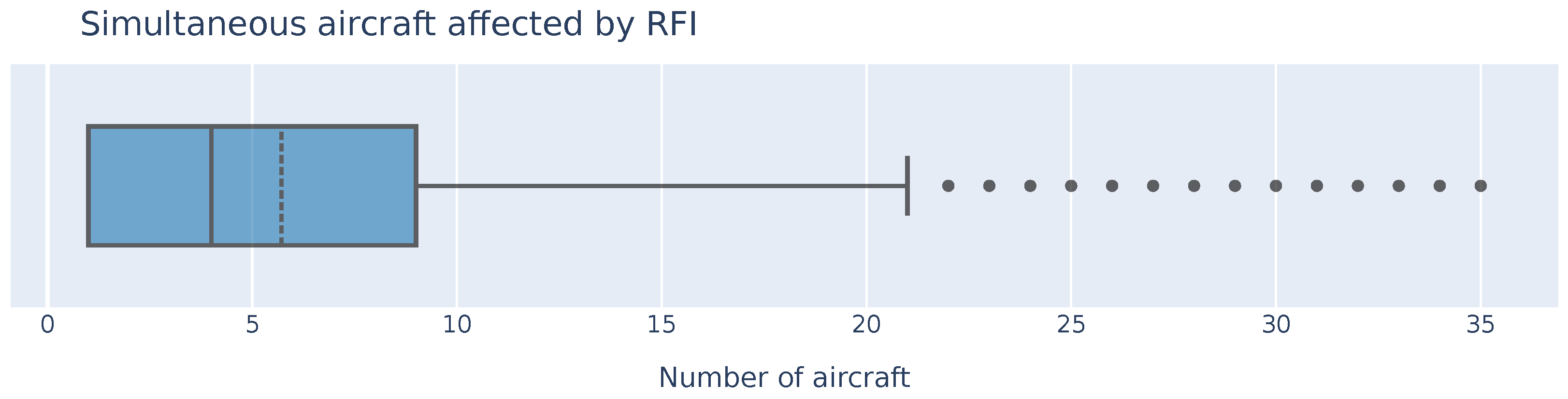
3.3. Number of Aircraft Affected Simultaneously by RFI

The number of aircraft that are affected simultaneously by RFI activities in AoI-1 was obtained by counting the number of aircraft transmitting a NACp value of 0 for each timestamp. Figure 5 depicts this data by means of a box plot. It indicates that, on average, a little less than six aircraft were concurrently affected by RFI. Although during most of the time four or less aircraft transmitted a NACp value of 0 at the same time, up to thirty-five aircraft were observed to be affected by RFI simultaneously. This is an important metric because the more aircraft that are simultaneously affected by RFI, the greater the chance that one or more aircraft will require ATC support.

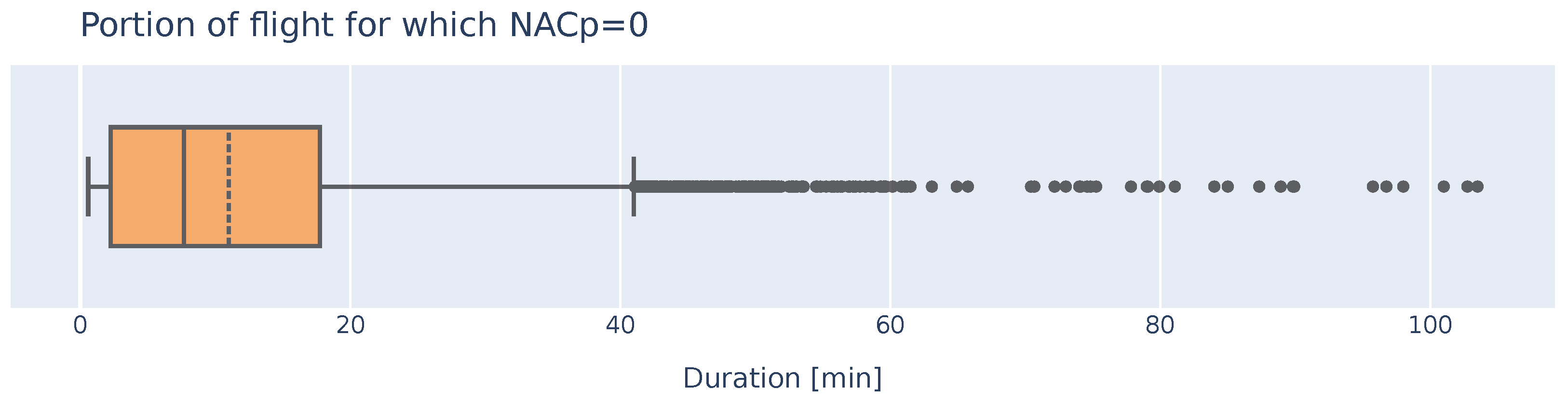
3.4. Portion of Flight

For each of the flights affected by RFI activities, the duration for which the NACp value was equal to 0 was calculated, see Figure 6. While RFI-affected flights in AoI-1 transmitted an average NACp value of 0 for less than 11 min, some flights were affected for more than an hour. Inertial navigation systems (INS) drift over time and therefore can only be used as a sole source of navigation for a limited amount of time. Alternatively, aircraft affected by RFI will need to revert to other means of navigation, such as terrestrial radio navigation provided they are adequately equipped. Consequently, the duration for which an aircraft is affected by RFI is an important metric to monitor.

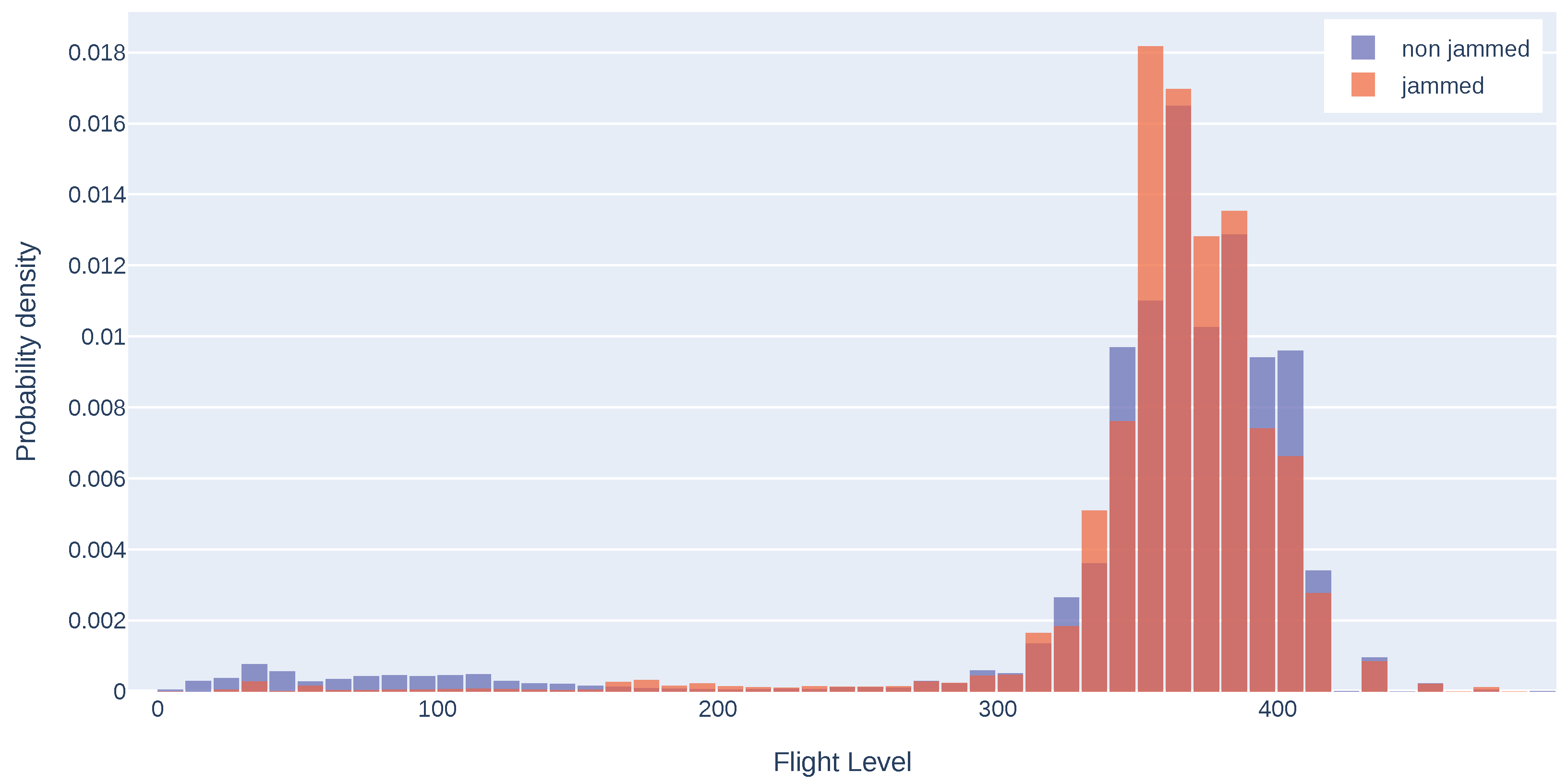
3.5. Altitude of Flights Affected by RFI

The intensity of RFI was not equally distributed over AoI-1. Therefore, to evaluate and assess the dependency of an aircraft’s altitude to its sensitivity to GNSS RFI, a second zone called AoI-2, which is substantially smaller than AoI-1, was defined. As indicated with a red box in Figure 1, this second zone is located between the cities of Varna and Dobrich in Bulgaria. For all flights that passed through AoI-2 during the selected observation period, both the altitude at which they flew and whether a NACp value of 0 was transmitted, were evaluated.
Figure 7 depicts the probability distribution of the flight levels (FL) of both the flights not affected by RFI (in blue) and the flights affected by RFI (in red). The data suggest that most aircraft movements in AoI-2 were conducted above FL300. Furthermore, it can be inferred that the probability distributions differ significantly for flights conducted below FL200; aircraft flying a low(er) altitude seem to be less susceptible to GNSS RFI. This circumstance indicates that the GNSS receivers of the aircraft must have line of sight to the source of the RFI in order to be influenced by it. Indeed, due to the Earth’s curvature, the radio horizon where an RFI source may affect an airborne receiver increases with increasing altitude.

3.6. Limitations

The method and results presented in this paper are subject to a number of limitations. The NACp value transmitted by aircraft via ADS-B is used to identify RFI activities. Especially for aircraft with more robust integration of GNSS and inertial sensors, the decrease of the transmitted NACp value and thus the classification of the aircraft to be affected by RFI can therefore be delayed. This circumstance may result in both the geographical area affected by RFI activities, see Figure 2, and the identified temporal duration of RFI activities, see Figure 6, not being completely representative. Furthermore, the method presented in this paper cannot detect flights that already have a NACp value of 0 before entering the AoI and maintain this value within the AoI.
The analysis presented is conducted on the basis of data collected by a network of land-based receivers. However, large portions of AoI-1 are located over the Black Sea for which ADS-B coverage is limited or does not exist. Moreover, since the beginning of the conflict in Ukraine, no civilian aircraft movements have been recorded in this area. Consequently, data availability and quality in AoI-1 is not uniform. Furthermore, it must be taken into account that certain results presented in this paper strongly depend on the chosen geometry and dimension of the AoI, see for instance the percentage of daily flights affected by RFI depicted in Figure 3.

4. Conclusions and Outlook

In recent years, RFI activities have increasingly influenced and affected commercial aviation. In this paper, we showed that RFI activities in the region of the Black Sea impacted a substantial number of commercial flights over an observation period between February and the end of August 2022. Indeed, up to 1300 flights were impacted by RFI on a daily basis in AoI-1. Subsequently, RFI activities, such as as the ones described and considered in this paper, might have an impact on the efficiency of civil aviation. The extent of the problem can significantly impact the planned rationalisation of ground-based navigation and surveillance infrastructure. This may lead to both higher costs and a slowdown of the modernisation of air navigation services. This paper provides the foundation for a future expansion of the proposed methodology to achieve near real-time situation awareness about RFI on the basis of ADS-B data, as recommended by European Union Aviation Safety Agency [10]. Consequently, future work will consist of extending the proposed methodology to other areas of interest, such as the Kaliningrad area. In addition, estimating the number of flights and/or aircraft that rely solely on GNSS for navigation and cannot switch to alternative methods such as radio or inertial navigation systems is of great importance, as these flights may suffer the biggest impact on their ability to navigate when affected by RFI.

Author Contributions

Conceptualization, B.F. and M.F.; methodology, B.F.; data curation, B.F.; software, B.F. and X.O.; validation, B.F., M.F. and M.W.; writing—original draft preparation, M.W. and B.F.; writing—review and editing, M.W., B.F., M.F. and X.O.; visualization, B.F. and X.O.; supervision, project administration, funding acquisition, M.F. All authors have read and agreed to the published version of the manuscript.

Funding

This research was funded by Armasuisse W+T, grant number 047-29.

Institutional Review Board Statement

Not applicable.

Informed Consent Statement

Not applicable.

Data Availability Statement

Not applicable.

Acknowledgments

The authors would like to thank Martin Strohmeier for his valuable comments and inputs to the project.

Conflicts of Interest

The authors declare no conflict of interest.

References

  1. International Civil Aviation Organization. Global Air Navigation Plan (ICAO Document 9750). Available online: https://www.icao.int/publications/documents/9750_2ed_en.pdf (accessed on 14 October 2022).
  2. Single European Sky ATM Research. European ATM Master Plan. Available online: https://www.sesarju.eu/masterplan (accessed on 14 October 2022).
  3. Airbus. In-Service Information–GNSS loss and GNSS interferences on Airbus a/c. Available online: https://www.airbus-win.com/wp-content/uploads/2019/03/gnss-loss-and-gnss-interferences-on-airbus-ac-1.pdf (accessed on 1 November 2022).
  4. Fol, P.; Felux, M. Identification and operational impact analysis of GNSS RFI based on flight crew reports and ADS-B data. In Proceedings of the International Workshop on CNS/ATM, Tokyo, Japan, 5–6 March 2022; pp. 33–40. [Google Scholar]
  5. Liu, Z.; Lo, S.; Walter, T. Characterization of ADS-B performance under GNSS interference. In Proceedings of the 33rd International Technical Meeting of the Satellite Division of the Institute of Navigation (ION GNSS+ 2020), Virtual Event, 22–25 September 2020; pp. 3581–3591. [Google Scholar]
  6. Pleninger, S.; Hospodka, J.; Pilmannová, T.; Topková, T.; Lukeš, P.; Steiner, J.; Kraus, J. Jamming of GNSS receiver on B737MAX aircraft and its impact on ADS-B technology. In Proceedings of the 2020 New Trends in Civil Aviation (NTCA), Prague, Czech Republic, 23–24 November 2020; pp. 123–128. [Google Scholar]
  7. Osechas, O.; Felux, M.; Fohlmeister, F.; Dautermann, T. Impact of RFI on GNSS and avionics–A view from the cockpit. In Proceedings of the 34th International Technical Meeting of the Satellite Division of The Institute of Navigation (ION GNSS+ 2021), St. Louis, MO, USA, 20–24 September 2021; pp. 1142–1159. [Google Scholar]
  8. Federal Aviation Authority. ATCSCC Advisory. Available online: https://www.fly.faa.gov/adv/adv_otherdis.jsp?advn=69&adv_date=10172022&facId=D10/ZFW&title=D10+GPS+ANOMALIES&titleDate=10/17/22 (accessed on 1 November 2022).
  9. Darabseh, A.; Bitsikas, E.; Tedongmo, B. Detecting GPS jamming incidents in Opensky data. In Proceedings of the 7th OpenSky Workshop, Zurich, Switzerland, 21–22 November 2019; Volume 67, pp. 97–108. [Google Scholar]
  10. European Union Aviation Safety Agency. Safety Information Bulletin Operations–ATM/ANS. Available online: https://ad.easa.europa.eu/blob/EASA_SIB_2022_02.pdf/SIB_2022-02_1 (accessed on 1 November 2022).
  11. Figuet, B.; Waltert, M.; Monstein, R.; Felux, M. Impact of GNSS outage on mid-air collision risk. In Proceedings of the International Workshop on CNS/ATM, Tokyo, Japan, 25–27 October 2022; pp. 41–48. [Google Scholar]
  12. Lukeš, P.; Topková, T.; Vlček, T.; Pleninger, S. Recognition of GNSS jamming patterns in ADS-B data. In Proceedings of the 2020 New Trends in Civil Aviation (NTCA), Prague, Czech Republic, 23–24 November 2020; pp. 9–15. [Google Scholar]
  13. Jonáš, P.; Vitan, V. Detection and localization of GNSS radio interference using ADS-B data. In Proceedings of the 2019 International Conference on Military Technologies (ICMT), Brno, Czech Republic, 30–31 May 2019; pp. 1–5. [Google Scholar]
  14. Jackson, B.; Wang, S.; Inkol, R. Emitter Geolocation Estimation Using Power Difference of Arrival; Defence R&D Canada Technical Report DRDC Ottawa TR 2011-040: Ottawa, ON, Canada, 2011; p. 51. [Google Scholar]
  15. Liu, Z.; Lo, S.; Walter, T. GNSS interference characterization and localization using Opensky ADS-B data. Proceedings 2020, 59, 10. [Google Scholar] [CrossRef]
  16. Liu, Z.; Lo, S.; Walter, T. GNSS interference source localization using ADS-B data. In Proceedings of the 2022 International Technical Meeting of The Institute of Navigation, Long Beach, CA, USA, 25–27 January 2022; pp. 158–167. [Google Scholar]
  17. Liu, Z.; Lo, S.; Walter, T. GNSS interference detection using machine learning algorithms on ADS-B data. In Proceedings of the 34th International Technical Meeting of the Satellite Division of the Institute of Navigation (ION GNSS+ 2021), St. Louis, MO, USA, 20–24 September 2021; pp. 4305–4315. [Google Scholar]
  18. Schäfer, M.; Strohmeier, M.; Lenders, V.; Martinovic, I.; Wilhelm, M. Bringing up OpenSky: A large-scale ADS-B sensor network for research. In Proceedings of the IPSN-14 13th International Symposium on Information Processing in Sensor Networks, Berlin, Germany, 15–17 April 2014; pp. 83–94. [Google Scholar]
  19. Wiseman, J. GNSS Interference Map. Available online: http://www.gpsjam.org/ (accessed on 1 November 2022).
  20. Olive, X. Traffic, a toolbox for processing and analysing air traffic data. J. Open Source Softw. 2019, 4, 1518. [Google Scholar] [CrossRef] [Green Version]
  21. Sun, J. The 1090 Megahertz Riddle: A Guide to Decoding Mode S and ADS-B Signals, 2nd ed.; TU Delft OPEN Publishing: Delft, The Netherlands, 2021. [Google Scholar] [CrossRef]
Figure 1. Areas of interest AoI-1 (blue box) and AoI-2 (red box).
Engproc 28 00012 g001
Figure 2. Aircraft densities in AoI-1 over the period between February and August 2022: (a) number of observed aircraft positions reported within each hexadecimal bin in AoI-1; (b) number of observed aircraft positions reporting a NACp of 0 within each hexadecimal bin in AoI-1; (c) percentage of aircraft affected by RFI per hexadecimal bin in AoI-1.
Engproc 28 00012 g002
Figure 3. Number (blue) and percentage (red) of aircraft affected by RFI per day in AoI-1.
Engproc 28 00012 g003
Figure 4. Number of flights influenced by RFI activities per 30-min interval over the entire observation period. The colour varies as a function of the number of flights affected by RFI for the corresponding 30-min interval.
Engproc 28 00012 g004
Figure 5. Box plot of the number of aircraft simultaneously affected by RFI in AoI-1.
Engproc 28 00012 g005
Figure 6. Box plot of the duration during which aircraft affected by RFI in AoI-1 had a NACp value of 0 in AoI-1.
Engproc 28 00012 g006
Figure 7. Altitude distribution of all traffic (blue) vs. traffic affected by RFI (red) in AoI-2.
Engproc 28 00012 g007
Table 1. NACp and corresponding EPU values. From [21].
NACpEPU
11<0.00162 NM
10<0.0054 NM
9<0.0162 NM
8<0.05 NM
7<0.1 NM
6<0.3 NM
5<0.5 NM
4<1 NM
3<2 NM
2<4 NM
1<10 NM
0>10 NM or unknown
Disclaimer/Publisher’s Note: The statements, opinions and data contained in all publications are solely those of the individual author(s) and contributor(s) and not of MDPI and/or the editor(s). MDPI and/or the editor(s) disclaim responsibility for any injury to people or property resulting from any ideas, methods, instructions or products referred to in the content.

