
Drought Monitoring with Multiple Indices and Management through Various Techniques: A Review †

 , ,
, ,  , and
, and
Abstract
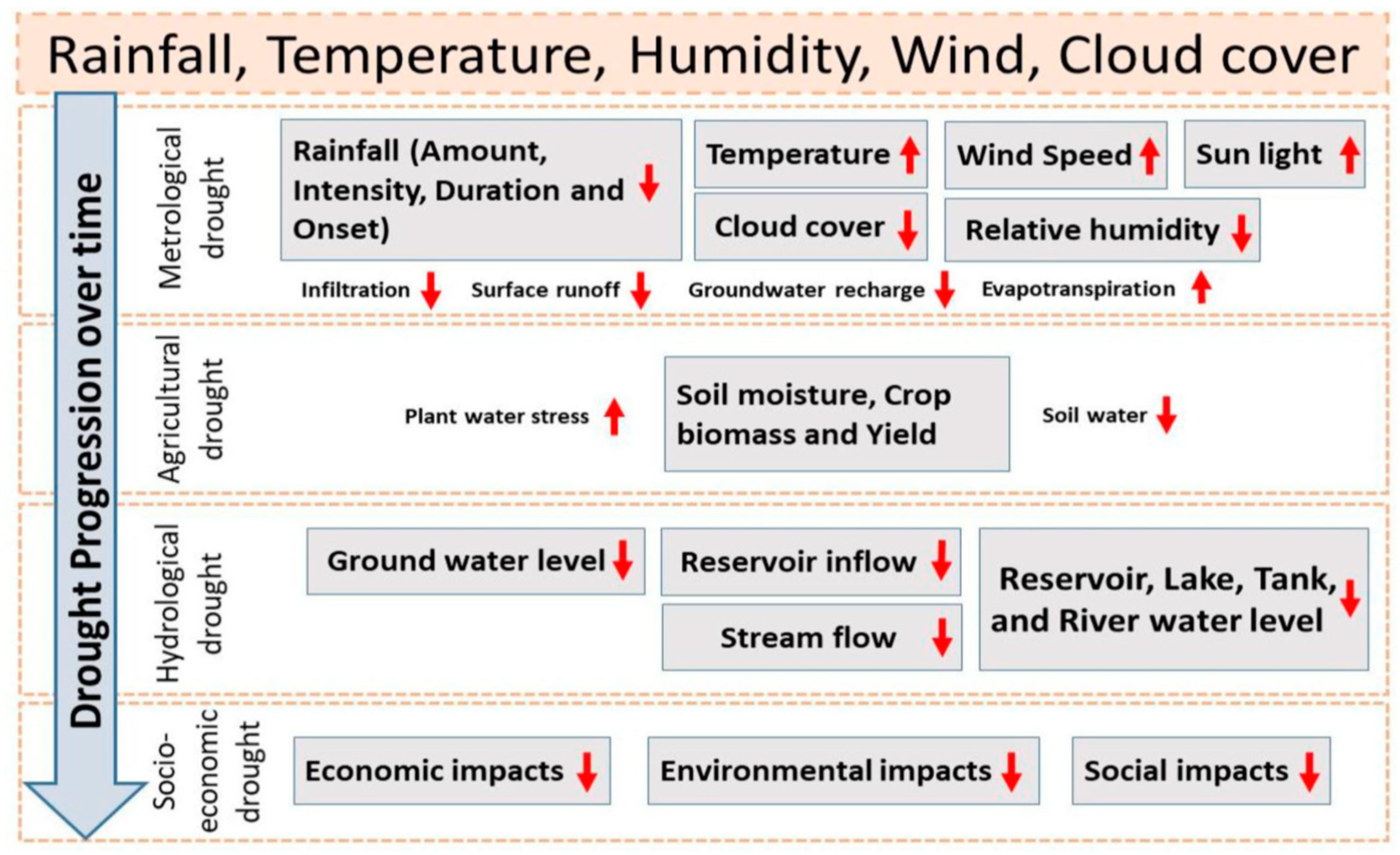
:1. Introduction
2. Materials and Methods
Drought Indices Overview and Comparison
3. Drought Management
- Institutional component—The institutional framework should include water, meteorology, agriculture, environment, and socioeconomic institutions to develop integrated drought risk management systems.
- Methodological component—This is the framework for drought risk assessment and vulnerability assessment, outlining procedures for assessing drought risks, analyzing climate trends and vulnerability factors, and mapping drought-prone areas for identification of risk elements and implementing mitigation measures.
- Public component—The framework for drought prevention and response outlines strategies for prompt responses, short-term readiness, and long-term resilience, requiring local institutions to develop and execute programs aimed at mitigating drought, similar to strategic planning.
- The operational component offers guidance for developing a decision support system for drought risk management, focusing on monitoring current conditions, predicting future droughts, and proactively implementing drought prevention.
- Application scope. Drought indicators utilize established monitoring networks to furnish practical information regarding drought danger. One of the challenges that researchers face is the development of technologies that can effectively integrate various sources of data and generate a unified drought indicator. Real-time apps facilitate the dissemination of readily available meteorological and hydrological data.
- Temporal scale. The assessment of drought hazards across different sectors necessitates varying temporal resolutions. However, drought indices have the capability to capture notable meteorological and hydrological fluctuations throughout a range of time periods.
- Spatial scale. The effective management of drought risk necessitates a concentrated approach at both regional and local levels, owing to the inherent unpredictability of hydrometeorological conditions. The utilization of standardized methodologies for assessing drought hazards facilitates the generation of maps that can be applied across various locations.
- Frequency analysis. The examination of time series data on drought indices can offer valuable insights on the susceptibility of a basin to the development, progression, and endurance of droughts, hence facilitating the prediction of droughts in real-time.
4. Conclusions and Future Directions
Author Contributions
Funding
Institutional Review Board Statement
Informed Consent Statement
Data Availability Statement
Conflicts of Interest
References
- IPCC. Managing the risks of extreme events and disasters to advance climate change adaptation. In A Special Report of Working Groups, I and II of the Intergovernmental Panel on Climate Change; Field, C.B., Stocker, T., Qin, D., Barros, V., Eds.; Cambridge University Press: Cambridge, UK, 2012. [Google Scholar] [CrossRef]
- Gimeno-Sotelo, L.; Kenawy, A.E.; Franquesa, M.; Noguera, I.; Fernández-Duque, B.; Domínguez-Castro, F.; Peña-Angulo, D.; Reig, F.; Sorí, R.; Gimeno, L.; et al. Assessment of the global coherence of different types of droughts in model simulations under a high anthropogenic emission scenario. ESS Open Arch. 2023. [Google Scholar] [CrossRef]
- Stagge, J.H.; Kohn, I.; Tallaksen, L.M.; Stahl, K. Modeling drought impact occurrence based on meteorological drought indices in Europe. J. Hydrol. 2015, 530, 37–50. [Google Scholar] [CrossRef]
- Wilhite, D.A. Drought as a Natural Hazard: Concepts and Definitions. In Handbook of Drought and Water Scarcity; University of Nebraska–Lincoln: Lincoln, NE, USA, 2000. [Google Scholar]
- Senay, G.B.; Velpuri, N.M.; Bohms, S.; Budde, M.; Young, C.; Rowland, J.; Verdin, J.P. Drought monitoring and assessment: Remote sensing and modeling approaches for the famine early warning systems network. In Hydro-Meteorological Hazards, Risks and Disasters; Elsevier: Amsterdam, The Netherlands, 2015; pp. 233–262. [Google Scholar] [CrossRef]
- Tadesse, T.; Wall, N.; Hayes, M.; Svoboda, M.; Bathke, D. Improving national and regional drought early warning systems in the greater horn of Africa. Bull. Am. Meteorol. Soc. 2018, 99, ES135–ES138. [Google Scholar] [CrossRef]
- Mishra, A.K.; Singh, V.P. A Review of Drought Concepts. J. Hydrol. 2010, 391, 202–216. [Google Scholar] [CrossRef]
- Wilhite, D.A.; Hayes, M.J. Drought: Management. In Atmosphere and Climate; CRC Press: Boca Raton, FL, USA, 2020; pp. 205–208. [Google Scholar]
- Dai, A. Drought Under Global Warming: A Review. Wiley Interdiscip. Rev. Clim. Chang. 2011, 2, 45–65. [Google Scholar] [CrossRef]
- Birch, E.L. A Review of “Climate Change 2014: Impacts, Adaptation, and Vulnerability” and “Climate Change 2014: Mitigation of Climate Change” Intergovernmental Panel on Climate Change. J. Am. Plann. Assoc. 2014, 80, 184–185. [Google Scholar] [CrossRef]
- Zargar, A.; Sadiq, R.; Naser, B.; Khan, F.I. A review of drought indices. Environ. Rev. 2011, 19, 333–349. [Google Scholar] [CrossRef]
- Vicente-Serrano, S.M.; Beguería, S.; López-Moreno, J.I. A Multiscalar Drought Index Sensitive to Global Warming: The Standardized Precipitation Evapotranspiration Index. J. Clim. 2010, 23, 1696–1718. [Google Scholar] [CrossRef]
- Yihdego, Y.; Vaheddoost, B.; Al-Weshah, R.A. Drought indices and indicators revisited. Arab. J. Geosci. 2019, 12, 1–12. [Google Scholar] [CrossRef]
- Ghatak, D.; Wilhite, D.A.; Hayes, M.J. Evaluation of the evaporative stress index as a complementary tool to the standardized precipitation index for drought monitoring in Nebraska. J. Hydrol. 2019, 568, 641–651. [Google Scholar]
- Sheffield, J.; Wood, E.F. Drought: Past Problems and Future Scenarios; Routledge: Abingdon, UK, 2012. [Google Scholar]
- Özger, M.; Mishra, A.K.; Singh, V.P. Low frequency drought variability associated with climate indices. J. Hydrol. 2009, 364, 152–162. [Google Scholar] [CrossRef]
- Sarvade, S.; Upadhyay, V.B.; Kumar, M.; Imran Khan, M. Soil and water conservation techniques for sustainable agriculture. In Sustainable Agriculture, Forest and Environmental Management; Springer: Singapore, 2019; pp. 133–188. [Google Scholar]
- Varshney, R.K.; Ribaut, J.M.; Buckler, E.S.; Tuberosa, R.; Rafalski, J.A.; Langridge, P. Can genomics boost productivity of orphan crops? Nat. Biotechnol. 2012, 30, 1172–1176. [Google Scholar] [CrossRef] [PubMed]
- Miletto, M. Water and Energy nexus: Findings of the World Water Development Report 2014. Proc. IAHS 2015, 366, 93–99. [Google Scholar] [CrossRef]
- Hayes, M.J.; Svoboda, M.D.; Wardlow, B.D.; Anderson, M.C.; Kogan, F. Drought monitoring: Historical and current perspectives. In Drought and Water Crises: Integrating Science, Management, and Policy; CRC Press: Boca Raton, FL, USA, 2011; pp. 159–176. [Google Scholar] [CrossRef]
- Qin, Y. Urban Flooding Mitigation Techniques: A Systematic Review and Future Studies. Water 2020, 12, 3579. [Google Scholar] [CrossRef]
- Mesfin, D.; Simane, B.; Belay, A.; Recha, J.W.; Schmiedel, U. Assessing the Adaptive Capacity of Households to Climate Change in the Central Rift Valley of Ethiopia. Climate 2020, 8, 106. [Google Scholar] [CrossRef]
- Svoboda, M.; Fuchs, B.; Integrated Drought Management Programme (IDMP). Handbook of Drought Indicators and Indices; Drought Mitigation Center Faculty Publications: Lincoln, NE, USA, 2016; p. 117. [Google Scholar]
- Gibbs, W.J.; Maher, J.V. Rainfall Deciles as Drought Indicators; Bureau of Meteorology Bulletin No. 48: Melbourne, Australia, 1967. [Google Scholar]
- Hayes, M.J. Drought Indices. In Van Nostrand’s Scientific Encyclopedia; John Wiley & Sons, Inc.: Hoboken, NJ, USA, 2006. [Google Scholar]
- Hayes, M.; Svoboda, M.; Wall, N.; Widhalm, M. The Lincoln Declaration on Drought Indices: Universal meteorological drought index recommended. Bull. Am. Meteorol. Soc. 2011, 92, 485–488. [Google Scholar] [CrossRef]
- Wu, H.; Hayes, M.J.; Weiss, A.; Hu, Q. An evaluation of the Standardized Precipitation Index, the China-Z Index and the statistical Z-score. Int. J. Climatol. 2001, 21, 745–758. [Google Scholar] [CrossRef]
- Byun, H.R.; Wilhite, D.A. Daily quantification of drought severity and duration. J. Clim. 1996, 5, 1181–1201. [Google Scholar]
- Alley, W.M. The Palmer Drought Severity Index: Limitations and assumptions. J. Appl. Meteorol. 1984, 23, 1100–1109. [Google Scholar] [CrossRef]
- Beguería, S.; Vicente-Serrano, S.M.; Reig, F.; Latorre, B. Standardized precipitation evapotranspiration index (SPEI) revisited: Parameter fitting, evapotranspiration models, tools, datasets and drought monitoring. Int. J. Climatol. 2014, 34, 3001–3023. [Google Scholar] [CrossRef]
- Sheffield, J.; Wood, E.F. Global Trends and Variability in Soil Moisture and Drought Characteristics, 1950–2000, from Observation-Driven Simulations of the Terrestrial Hydrologic Cycle. J. Clim. 2008, 21, 432–458. [Google Scholar] [CrossRef]
- Kumar, R.; Merwade, V. Droughts Assessment using Remote Sensing and Soil Moisture Index. J. Hydrol. Eng. 2014, 19, 554–568. [Google Scholar]
- Zhang, L.; Feng, H.; Dong, Q.; Jin, N.; Zhang, T. Mapping irrigated and rainfed wheat areas using high spatial–temporal resolution data generated by Moderate Resolution Imaging Spectroradiometer and Landsat. J. Appl. Remote Sens. 2018, 12, 046023. [Google Scholar] [CrossRef]
- Shashikant, V.; Mohamed Shariff, A.R.; Wayayok, A.; Kamal, M.R.; Lee, Y.P.; Takeuchi, W. Utilizing TVDI and NDWI to Classify Severity of Agricultural Drought in Chuping, Malaysia. Agronomy 2021, 11, 1243. [Google Scholar] [CrossRef]
- Su, C.; Ryu, D.; Crow, W.T.; Western, A.W. Beyond triple collocation: Applications to soil moisture monitoring. J. Geophys. Res. Atmos. 2014, 119, 6419–6439. [Google Scholar] [CrossRef]
- Rossi, G.; Castiglione, L.; Bonaccorso, B. Guidelines for Planning and Implementing Drought Mitigation Measures. In Methods and Tools for Drought Analysis and Management; Rossi, G., Vega, T., Bonaccorso, B., Eds.; Water Science and Technology Library; Springer: Dordrecht, The Netherlands, 2007; Volume 62. [Google Scholar] [CrossRef]
- Kindler, J.; Okruszko, T. Integrated drought management programmer in central and Eastern Europe (IDMP CEE). In Annals of Warsaw University of Life Sciences-SGGW. Land Reclamation; Szkoła Główna Gospodarstwa Wiejskiego w Warszawie: Warszawa, Poland, 2014; p. 46. [Google Scholar]
- Merabtene, T.; Kawamura, A.; Jinno, K.; Olsson, J. Risk assessment for optimal drought management of an integrated water resources system using a genetic algorithm. Hydrol. Process. 2002, 16, 2189–2208. [Google Scholar] [CrossRef]
- Zhang, D.; Wang, G.; Zhou, H. Assessment on agricultural drought risk based on variable fuzzy sets model. Chin. Geogr. Sci. 2011, 21, 167–175. [Google Scholar] [CrossRef]


| Sr# | Indices | Input Parameters | Description | Methodology | Applications |
|---|---|---|---|---|---|
| 1 | Aridity Anomaly Index (AAI) | P, T, PET, ET | The Aridity Anomaly Index (AAI) is a drought indicator that compares actual aridity with the average, with positive numbers indicating moisture stress and negative values indicating excess moisture. | AAI is defined as the ratio of potential evapotranspiration (P) to average annual precipitation (PET). AAI = P/PET | Operationally accessible for India [23]. |
| 2 | Deciles Index | P | The study assesses precipitation frequency and distribution by ranking the entire record of rainfall data for a specific area. The first decile represents the highest 10% of values, while the fifth decile represents the median. | Considers various temporal scales, including daily, weekly, monthly, seasonal, and annual values, allowing for comparison of current data with historical records for a specific period. | Simple to compute; Australian examples are helpful [24]. |
| 3 | Percent of normal index (PNI) | P | This mathematical operation compares and contrasts different time periods across geographical locations, calculating on various timescales, divides actual precipitation by usual precipitation, and multiplies by 100. | To calculate, divide actual precipitation by typical precipitation for the time being considered and multiply by 100. | This tool can efficiently identify and monitor various drought-related impacts [25]. |
| 4 | Standardized Precipitation Index (SPI) | P | SPI is a meteorological indicator that calculates precipitation likelihood using historical records, ranging from 1 month to 48 months. It indicates rainy and dry events and is suitable for areas with limited data or unified datasets. | SPI can be calculated by probability of precipitation for any timescale. Where X = Precipitation for station, Xm mean precipitation and is standard deviation. SPI can be calculated with missing data and recalculate output when more data are available. | SPI is a climate monitoring tool that measures drought, agricultural impacts, and hydrological impacts on gridded precipitation datasets [26]. |
| 5 | China Z Index (CZI) | P | The CZI and SPI are indices that use precipitation data to assess wet and dry periods. They follow a Pearson type III distribution and use monthly intervals ranging from 1 to 72 months to detect droughts of varying durations. | The monitoring ap-proach, similar to the Standardized Precipitation Index (SPI), observes wet and dry events over different time periods, computing | Observes wet and dry events over different time periods, computing both moisture-related and non-moisture events over multiple time steps [27]. |
| 6 | Reconnaissance Drought Index (RDI) | P, T | The Drought Severity Index (RDI) is a comprehensive water balance equation that considers precipitation and evapotranspiration, offering three outputs: initial, normalized, and standardized. | (RDI) is based on the precipitation to potential evapotranspiration ratio (P/PET). | Potential evapotranspiration provides a more accurate water balance assessment than the Standardized Precipitation Index (SPI) [28]. |
| 7 | Palmer Drought Severity Index (PDSI) | P, T and AWC | The calculation considers monthly temperature, precipitation data, soil water-holding capacity, and potential moisture loss due to temperature influences. | The Palmer Drought Severity Index (PDSI) is determined via the utilization of precipitation and temperature data, alongside the specific Available Water Content (AWC) of the soil in a certain locality. | PDSI is a global tool used to identify and monitor droughts affecting agriculture, with numerous examples of its use over the years [29]. |
| 8 | Standardized Precipitation Evapotranspiration Index (SPEI) | P, T | The SPEI is a drought index that uses temperature data to identify and characterize wet and dry conditions, with applicability for up to 48 months. | Thornthwaite’s 1948 Standardized Precipitation Evapotranspiration Index (SPEI) is a water balance methodology used to calculate the difference between precipitation and potential evapotranspiration. | To track drought situations, providing a universally applicable tool for evaluating climate change impact in model output [30]. |
| Sr# | Indices | Input Parameters | Description | Methodology | Applications |
|---|---|---|---|---|---|
| 1 | Soil Moisture Anomaly (SMA) | P, T, and AWC | SMA helps detect anomalies from the norm by expressing the difference between the measured soil moisture as well as the long-term average. | SMA = Current Soil Moisture Content − Historical or Expected Soil Moisture Content/Historical or Expected Soil Moisture Content | created and widely used to track the effects of drought on global agriculture and crop production [31]. |
| 2 | Soil Moisture Deficit Index (SMDI) | Modeling approach | SMD measures the amount of moisture loss by quantifying the difference between the actual soil moisture level and the field capacity. | SMD = Field Capacity − Current Soil Moisture Content | Useful for identifying and monitoring drought affecting agriculture [32]. |
| 3 | Soil Moisture Index (SMI) | Current Soil Moisture Content Max. and Min. Soil Moisture Content Reference Period | By comparing the current soil moisture content with the maximum and minimum values over a given period, SMI evaluates the soil moisture conditions. | SMI = (Max SMC − Min SMC)/Current Soil Moisture Content − Min SMC) × 100 Researchers can modify SMI formulations based on factors like soil type, climate, and soil moisture sensitivity, ensuring varying results for different applications. | The Soil Moisture Index (SMI) is a statistical tool that compares soil moisture levels over time, assessing soil conditions, with its precise phrasing varying based on assessment objectives [33]. |
| 4 | Normalized Soil Moisture Index (NSMI) | Current Soil Moisture Con-tent Max. and Min. Soil Moisture Content | By standardizing the soil moisture content in relation to the range of variability, NSMI makes it easier to compare results from various places. | NSMI = Current Soil Moisture Content − Minimum Soil Moisture Content/Maximum Soil Moisture Content − Minimum Soil Moisture Content | drought monitoring, agricultural planning, water resource management, environmental studies, hydrological modeling, and climate change [34]. |
| 5 | Surface soil moisture Anomaly (SSMA) | Current Surface Soil Moisture Content (SSM): Historical or Expected (SSMC): Temporal Period | SSMA assesses irregularities in the soil’s top layer and offers information about transient changes in moisture content. | SSMA = Current Surface Soil Moisture Content − Historical or Expected Surface Soil Moisture Content/Historical or Expected Surface Soil Moisture Content | drought monitoring, agricultural planning, water resource management, environmental studies, hydrological modeling, and climate change studies [35]. |
| Category | Long Term Actions | Short Term Actions |
|---|---|---|
| Demand reduction | Economic incentives aimed at encouraging water conservation encompass strategies such as the substitution of irrigated crops with drought-resistant alternatives and the promotion of water recycling practices within industrial sectors. | There is a current emphasis on promoting public awareness regarding water conservation, which includes the implementation of various measures such as restrictions on urban water usage, limitations on irrigation for crops, and the enforcement of forced rationing. |
| Water supply increase | The potential strategies encompass wastewater reutilization, inter-basin water conveyance, construction of additional reservoirs, augmentation of storage capacity, establishment of agricultural ponds, and implementation of measures to mitigate seepage and evaporation losses. | The suggested measures encompass enhancing water systems, employing low-quality, high-cost sources, tapping into groundwater reserves, and increasing diversion by loosening limits on ecological or recreational usage. |
| Impact minimization | The primary objectives of the educational initiatives are to enhance the state of preparedness for drought conditions, reallocate water resources in accordance with their quality, establish systems for early warning, and execute insurance programs. | Temporary water reallocation, allocation of resources, and public assistance programs are implemented as strategies to mitigate revenue losses, alleviate tax burdens, defer payments, and provide crop insurance coverage. |
Disclaimer/Publisher’s Note: The statements, opinions and data contained in all publications are solely those of the individual author(s) and contributor(s) and not of MDPI and/or the editor(s). MDPI and/or the editor(s) disclaim responsibility for any injury to people or property resulting from any ideas, methods, instructions or products referred to in the content. |
© 2023 by the authors. Licensee MDPI, Basel, Switzerland. This article is an open access article distributed under the terms and conditions of the Creative Commons Attribution (CC BY) license (https://creativecommons.org/licenses/by/4.0/).
Share and Cite
Safdar, M.; Shahid, M.A.; Zaman, M.; Rasul, F.; Muzammal, H.; Raza, A.; Sabir, R.M.; Zafar, U. Drought Monitoring with Multiple Indices and Management through Various Techniques: A Review. Eng. Proc. 2023, 56, 307. https://doi.org/10.3390/ASEC2023-16602
Safdar M, Shahid MA, Zaman M, Rasul F, Muzammal H, Raza A, Sabir RM, Zafar U. Drought Monitoring with Multiple Indices and Management through Various Techniques: A Review. Engineering Proceedings. 2023; 56(1):307. https://doi.org/10.3390/ASEC2023-16602
Chicago/Turabian StyleSafdar, Muhammad, Muhammad Adnan Shahid, Muhammad Zaman, Fahd Rasul, Hafsa Muzammal, Aamir Raza, Rehan Mehmood Sabir, and Usman Zafar. 2023. "Drought Monitoring with Multiple Indices and Management through Various Techniques: A Review" Engineering Proceedings 56, no. 1: 307. https://doi.org/10.3390/ASEC2023-16602
APA StyleSafdar, M., Shahid, M. A., Zaman, M., Rasul, F., Muzammal, H., Raza, A., Sabir, R. M., & Zafar, U. (2023). Drought Monitoring with Multiple Indices and Management through Various Techniques: A Review. Engineering Proceedings, 56(1), 307. https://doi.org/10.3390/ASEC2023-16602