Abstract
This study focused on the urban river management using geospatial techniques of the Dehradun Municipal Corporation (DMC) and its associated watersheds of the Bindal River and Rispana River. Shutter Radar Topography Mission (SRTM) Digital Elevation Model (DEM) data with a spatial resolution of 30 m was used for the delineation of watershed boundaries and drainage networks and for identifying topographic features. Additionally, Sentinel-2 data with a spatial resolution of 10 m were utilized to analyze change in land use in 2017 and 2022. The drainage patterns in the Bindal and Rispana watersheds were dendritic in shape with moderate relief. The study found a significant decline in agricultural land from 17.94% in 2017 to 14.66% in 2022. This decline was accompanied by an increase in built-up area from 32.53% to 35.44%. The increased biotic pressure poses a critical threat to river health and biodiversity. This study highlights the urgent need for comprehensive river management strategies to efficiently monitor biotic pressure due to transformations in land use. This research will be beneficial to diverse stakeholders, including decision-makers and urban planners engaged in the sustainable management of water resources and urban development.
1. Introduction
The world is moving toward a freshwater crisis which affects river systems and their surrounding environments [1]. Urbanization, climate change, the over-exploitation of natural resources, and an increasing population pose a threat to the ecosystem services and biodiversity of freshwater resources [2,3]. With increasing land development and human activities in nearby and distant watersheds, the supplies of drinking water for cities are stressed due to potential contamination. India’s 35% urban population generates almost 65% of the country’s wastewater [4]. Urban river management in India is crucial for controlling the effects of growing anthropogenic pressure on the river system [5]. Urban river management refers to the comprehensive planning, development, and sustainable utilization of river resources within urban areas. The maintenance and restoration of these resources are essential elements of effective urban river management. This may include maintaining water quality, managing river flow, taking steps to prevent flooding, reviving riverfront areas for recreation and biodiversity, and making sure adequate sanitation and wastewater treatment. The roles of digital elevation models (DEMs) and multispectral sensor-based geospatial techniques are significant for urban river management studies. Earlier geospatial techniques are tedious, expensive, and more error-prone than the latest geospatial techniques. Spatial and temporal analyses of an area will provide us with a comprehensive view of the topography and changes in the land use pattern of an area [6]. In this study, we evaluate the land use changes and topographical factors of the Dehradun Municipal Corporation (DMC) and its associated watersheds. This study’s main concern is the impact of humans on nearby river systems. Urban planners and water resource managers who are involved in urban river management and sustainable development will benefit from the findings of this study.
2. Methods
2.1. Study Area
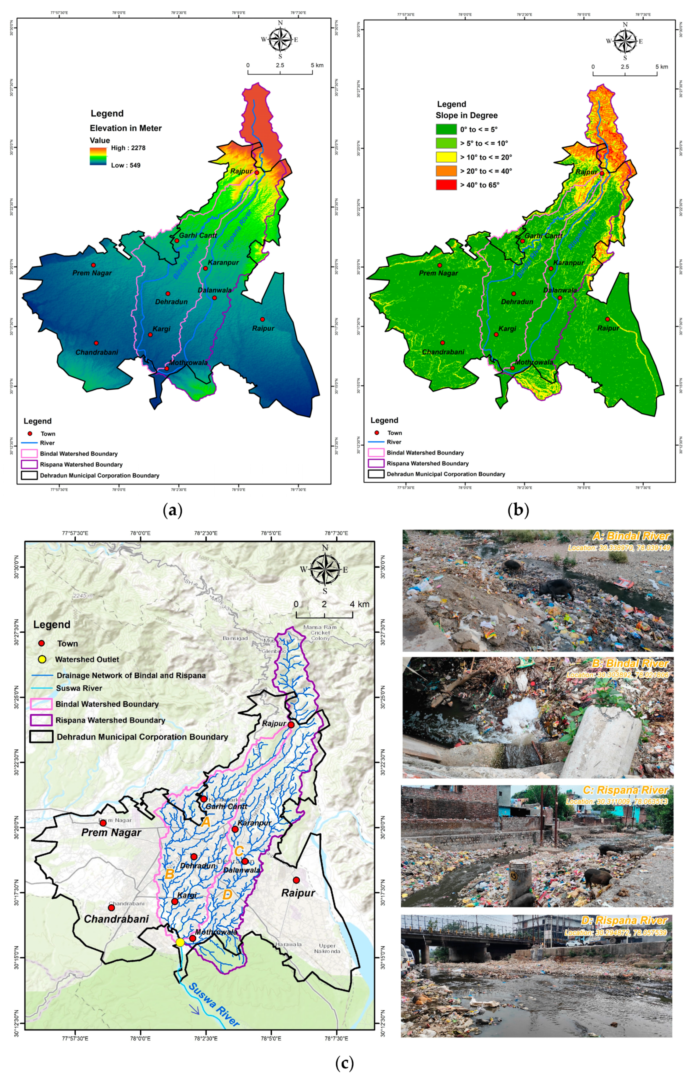
The Dehradun Municipal Corporation (DMC) is the lifeline of the Doon Valley in Uttarakhand, India. It is the Central Business District (CBD) of Dehradun City. After originating from the Lesser Himalayas, the Bindal River, with a total length of ~23 km, and the Rispana River, with a total length of ~27 km, flow through the DMC before merging to form the Suswa River near Mothrowala, which then flows to the Song River and eventually joins the Ganga River [7]. The study area coordinates fall between a latitude of 30°13′45″ N to 30°27′30″ N and a longitude of 77°55′00″ E to 78°08′45″ E. For the total study area, the watershed areas of the Bindal and Rispana Rivers. Viz., 44.40 km2 and 58.09 km2, are combined with the DMC area of 183.70 km2 [8], excluding the watershed area which falls inside the DMC area. Finally, the study covers a total area of 204.23 km2 and has elevations that range from 549 m to 2278 m. The region receives ~2000 mm of average annual rainfall each year. The winters are extremely cold, with a temperature of 2 °C, and the summers are mostly hot, with a temperature of 43 °C. A map of the study area is providedd in Figure 1 below.
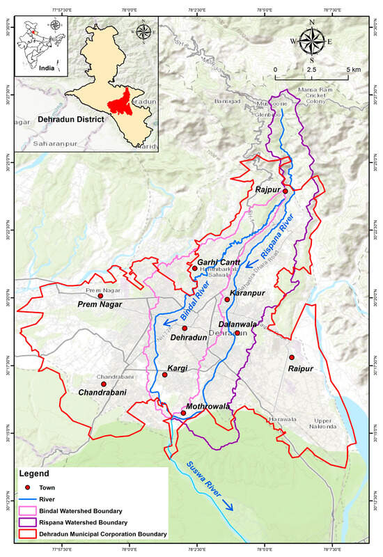
Figure 1.
Study area map.
2.2. Materials and Methods
Digital elevation model (DEM) data and satellite-based multispectral sensor data were integrated to understand the study area. Shutter Radar Topography Mission (SRTM) DEM data at a 30 m resolution for the year 2014 were used for a topographical evaluation [9]. These data were further processed using ArcGIS desktop software version 10.6 and spatial analysis tools for the delineation of watershed boundaries and drainage networks. The Sentinel 2 multispectral sensor data at a 10 m resolution for the years 2017 and 2022 were used for land use changes [10]. Land use changes were performed through the supervised classification method in ERDAS Imagine software version 16.6. The supervised classification method involves selecting specific representative samples for each land use class, referred to as training samples, and the accuracy of the classification largely relies on the quality of these training samples [11]. These samples are employed by image classification algorithms to recognize land use classes across the entire image. In this study, we applied the widely used Maximum Likelihood Classifier (MXL) as our supervised classification algorithm. Further, the statistical process was completed using ArcGIS desktop software. Additionally, elevation, slope, drainage network, and land use change maps of the study area were prepared.
3. Results and Discussion
Topographical factors such as elevation, slope, and drainage network, along with land use changes, are essential for urban river management studies. These factors are explained below.
3.1. Elevation
The elevation of the DMC and its associated watershed ranges from 549 m to 2278 m (Figure 2a). The higher the elevation, the greater the slope [12]. The DMC area has a low-to-moderate elevation range.
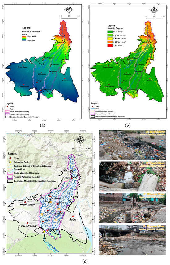
Figure 2.
(a) Elevation map; (b) slope map; (c) drainage network map.
3.2. Slope
The area’s steepness is indicated by its slope. According to Figure 2b, the slope was classified into five classes: very gentle (0° to <=5°), gentle (>5° to =10°), moderate (>10° to =20°), steep (>20° to =40°), and very steep (>40° to 65°). The majority of the area has a relatively gentle to medium slope. A gentle and moderate slope has high groundwater infiltration and less runoff, whereas a steep slope has low groundwater infiltration and less runoff [13]. Additionally, steep slope regions are vulnerable to soil erosion.
3.3. Drainage Network
A drainage network comprises all the paths of streams that flow toward a reference point. It is constrained by a topographically defined drainage divide. Rainfall falling on the far side of the drainage divide runs downslope into an adjoining drainage network. The drainage pattern is dendritic in shape. All the drainage inside the Bindal River and Rispana River watersheds drains through the DMC area in a south direction toward an outlet in Mothrowala (Figure 2c). Both rivers bring municipal households’ sewage waste and industrial effluent into the Suswa River, which joins the Song River near Jhabrawala and ultimately merges with the Ganga River near Tehari Farm, Raiwala, Uttarakhand, India. The drainage network’s role is crucial for understanding the anthropogenic threats near urban rivers.
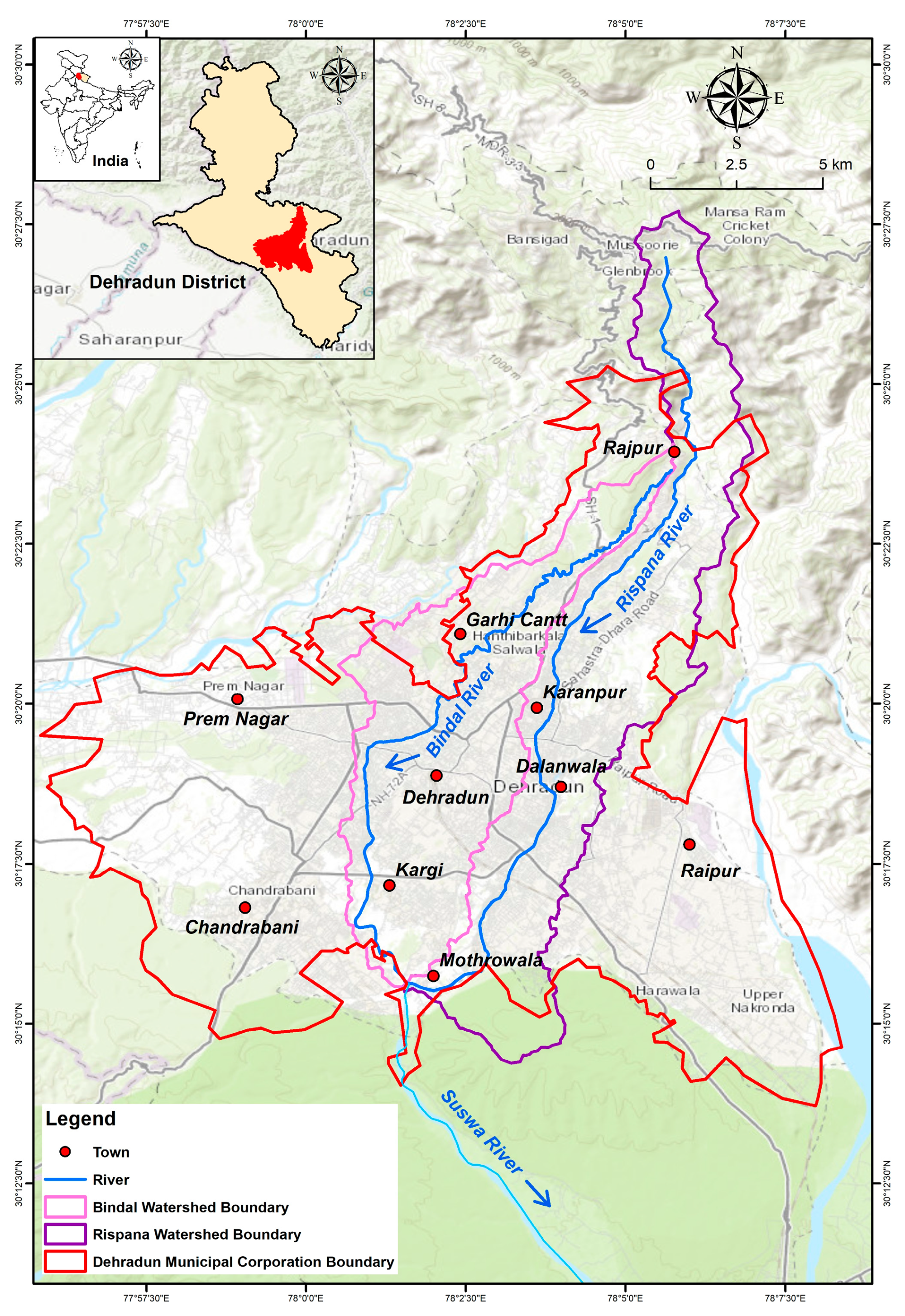
3.4. Land Use Changes
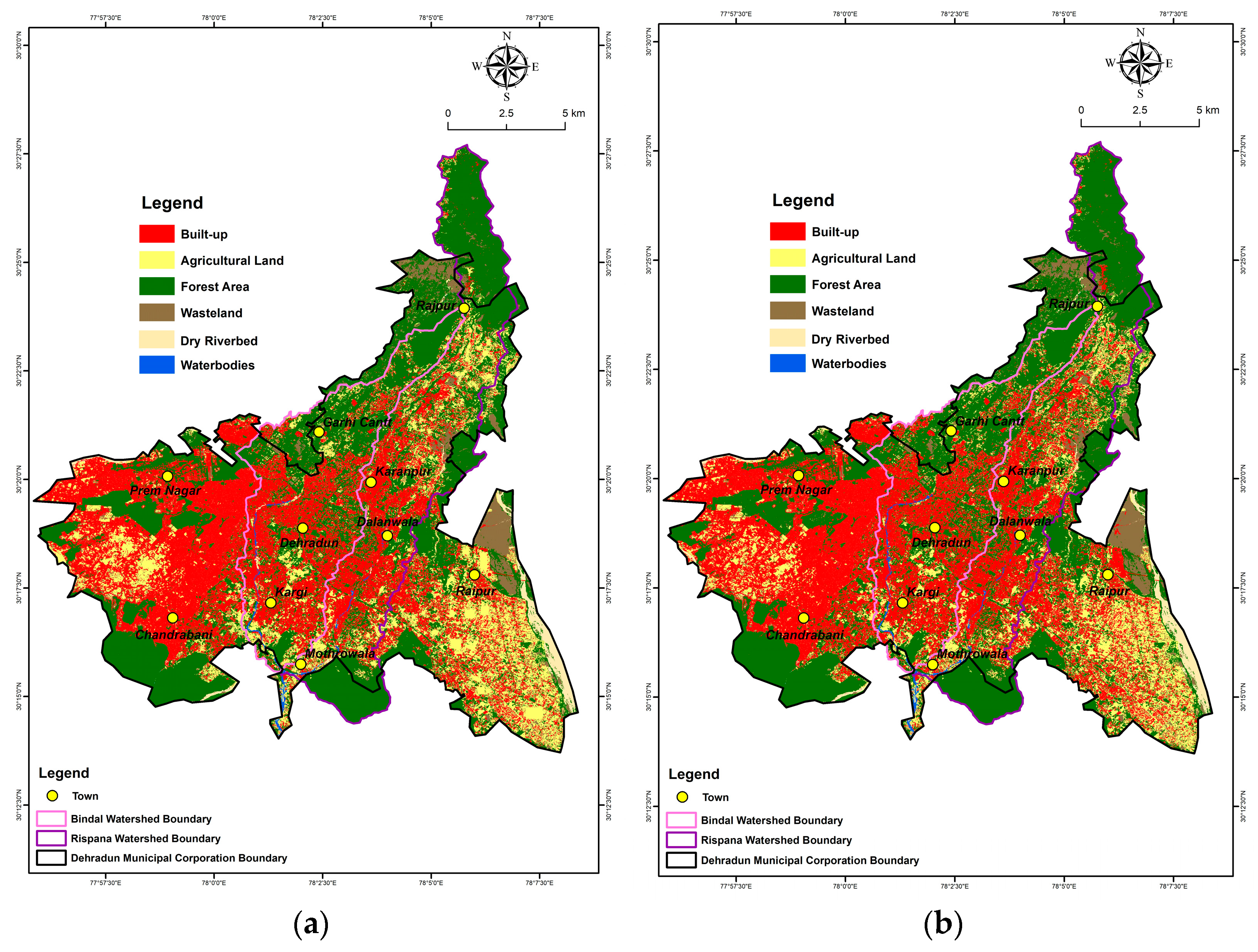
Multidisciplinary research on land use changes includes economics, geography, urban planning, and environmental studies [14,15]. It plays a crucial role in informing policies and practices that can help balance human development with the preservation of natural resources and ecosystems [16]. The supervised classification approach in ERDAS Imagine software was used in this study to create land use changes for the years 2017 and 2022. A statistical analysis was also performed using ArcGIS desktop software. The dominating classes in the area are dense vegetation and built-up land (Figure 3a,b). According to the analysis of land use changes, from 2017 to 2022, there was a 2.91% increase in built-up area and a 3.28% decrease in agricultural land area (Table 1). The changes in agricultural land area and built-up area depend on increasing population growth, the expansion of smart cities, and rapid socio-economic growth [17]. Also, increasing tourist pressure and the Dehradun climate are other significant factors for the rise in built-up area [18]. River health and biodiversity are under serious threat due to the increasing built-up area and other anthropogenic factors [19].
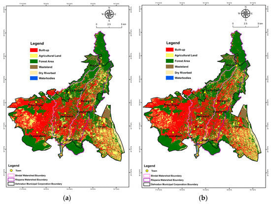
Figure 3.
(a) Land use map, 2017; (b) land use map, 2022.

Table 1.
Land Use changes analysis.
4. Conclusions
This study investigates the possible impacts of topographical factors and land use changes on urban river management using DEM and multispectral sensor based geospatial techniques. A comprehensive evaluation and interpretation implied that from 2017 to 2022, there was a change in the land use: the agricultural land area is decreasing, and the built-up area is increasing. The dendritic pattern of the watershed’s drainage system makes it easier to understand various topographical factors, including runoff and infiltration rate. The findings of this study demonstrate the increasing biotic pressure on urban rivers driven by municipal households’ sewage waste and industrial effluent which flow from small river systems to large river systems. In order to effectively monitor the biotic pressure caused by land use changes, this study emphasizes the urgent necessity for proper urban river management planning. This study will be useful to urban planners and policymakers who are involved in urban development and water resource management. Also, in the near future, topography and land use change-based studies will be significant for valuable and systematic urban river management.
Author Contributions
Conceptualization, A.M.; methodology, A.M., M.K. and R.B.; resources, A.M.; data curation, A.M.; writing—original draft preparation, A.M.; writing—review and editing, A.M., M.K. and R.B. All authors have read and agreed to the published version of the manuscript.
Funding
This research received no external funding.
Institutional Review Board Statement
Not applicable.
Informed Consent Statement
Not applicable.
Data Availability Statement
The data presented in this study are available upon request from the corresponding author.
Acknowledgments
The authors would like to thank their respective institutes for their constant encouragement and support.
Conflicts of Interest
The authors declare no conflicts of interest.
References
- Kummu, M.; Guillaume, J.H.; de Moel, H.; Eisner, S.; Flörke, M.; Porkka, M.; Siebert, S.; Veldkamp, T.I.; Ward, P.J. The world’s road to water scarcity: Shortage and stress in the 20th century and pathways towards sustainability. Sci. Rep. 2019, 6, 38495. [Google Scholar] [CrossRef] [PubMed]
- Grill, G.; Lehner, B.; Thieme, M.; Geenen, B.; Tickner, D.; Antonelli, F.; Babu, S.; Borrelli, F.; Cheng, L.; Crochetiere, H.; et al. Mapping the world’s free-flowing rivers. Nature 2019, 569, 215–221. [Google Scholar] [CrossRef] [PubMed]
- Huggins, X.; Gleeson, T.; Kummu, M.; Zipper, S.C.; Wada, Y.; Troy, T.J.; Famiglietti, J.S. Hotspots for social and ecological impacts from freshwater stress and storage loss. Nat. Commun. 2022, 13, 439. [Google Scholar] [CrossRef] [PubMed]
- NITI Aayog Report. Urban Wastewater Scenario in India. Available online: https://www.niti.gov.in/sites/default/files/2022-09/Waste-Water-A4_20092022.pdf (accessed on 28 August 2023).
- National Mission for Clean Ganga (NMCG) Report. Urban River Management Plan (URMP). A Strategic Framework for Managing Urban River Stretches in the Ganga River Basin. Available online: https://nmcg.nic.in/writereaddata/fileupload/48_Urban%20River%20Management%20Plan%20framework.pdf (accessed on 28 August 2023).
- Chin, A.; Gregory, K.J. Managing urban river channel adjustments. Geomorphology 2005, 69, 28–45. [Google Scholar] [CrossRef]
- Mani, A.; Kumari, M.; Badola, R. Morphometric analysis of Suswa River Basin using geospatial techniques. Eng. Proc. 2022, 27, 65. [Google Scholar]
- Mussoorie Dehradun Development Authority (MDDA) Report. Dehradun Master Plan-2041 (Draft). Available online: http://mddaonline.in/wp-content/uploads/2023/04/Dehradun-Master-Plan-2.0A.pdf (accessed on 29 August 2023).
- U.S. Geological Survey. Earth Explorer. Available online: https://earthexplorer.usgs.gov/ (accessed on 31 March 2023).
- European Space Agency (ESA) Copernicus Open Access Hub. Available online: https://scihub.copernicus.eu/ (accessed on 31 March 2023).
- Salah, M. A survey of modern classification techniques in remote sensing for improved image classification. J. Geomat. 2017, 11, 21. [Google Scholar]
- Mani, A.; Bansal, D.; Kumari, M.; Kumar, D. Land Use Land Cover Changes and Climate Change Impact on the Water Resources: A Study of Uttarakhand State. In River Conservation and Water Resource Management; Rai, P.K., Ed.; Springer Nature: Singapore, 2023; pp. 1–16. [Google Scholar]
- Mani, A.; Kumar, D. Morphometric Analysis of Manali Watershed of Beas River Basin for Watershed Management. VayuMandal 2020, 46, 21–29. [Google Scholar]
- Sterling, S.M.; Ducharne, A.; Polcher, J. The impact of global land-cover changes on the terrestrial water cycle. Nat. Clim. Chang. 2013, 3, 385–390. [Google Scholar] [CrossRef]
- Zhao, A.; Zhu, X.; Liu, X.; Pan, Y.; Zuo, D. Impacts of land use change and climate variability on green and blue water resources in the Weihe River Basin of northwest China. Catena 2016, 137, 318–327. [Google Scholar] [CrossRef]
- Jacobson, C.R. Identification and quantification of the hydrological impacts of imperviousness in urban catchments: A review. J. Environ. Manag. 2011, 92, 1438–1448. [Google Scholar] [CrossRef] [PubMed]
- Deng, X.; Huang, J.; Rozelle, S.; Zhang, J.; Li, Z. Impact of urbanization on cultivated land changes in China. Land Use Policy 2015, 45, 1–7. [Google Scholar] [CrossRef]
- Dey, J.; Sakhre, S.; Gupta, V.; Vijay, R.; Pathak, S.; Biniwale, R.; Kumar, R. Geospatial assessment of tourism impact on land environment of Dehradun, Uttarakhand, India. Environ. Monit. Assess. 2018, 190, 181. [Google Scholar] [CrossRef] [PubMed]
- Rana, D.; Bisht, A.; Mushtaq; Bhadula, S. Ichthyo-Faunal Diversity of Suswa River, Doon Valley, Uttarakhand, India. N. Y. Sci. J. 2017, 10, 106–112. [Google Scholar]
Disclaimer/Publisher’s Note: The statements, opinions and data contained in all publications are solely those of the individual author(s) and contributor(s) and not of MDPI and/or the editor(s). MDPI and/or the editor(s) disclaim responsibility for any injury to people or property resulting from any ideas, methods, instructions or products referred to in the content. |
© 2023 by the authors. Licensee MDPI, Basel, Switzerland. This article is an open access article distributed under the terms and conditions of the Creative Commons Attribution (CC BY) license (https://creativecommons.org/licenses/by/4.0/).