1. Introduction
People frequently complain that it can be dangerous to travel alone or at night, as safety is the primary concern. It is important to provide emergency location tracking so that the general public can commute or visit any destination in safety, even at unusual hours. Recognizing events and objects is one of the most important study areas that is now seeing an explosion among professionals in image processing. Because object tracking and detection are so widely used, it is important to be aware of their existence. The procedures and techniques employed in this recognition process are attracting increasing amounts of attention from researchers.
This study aims to provide a quick rundown of the recent advancements in surveillance technologies, including their ability to identify human subjects and spot strange behavior in a variety of applications. Due to their importance in interpreting information from both still and moving images, event recognition data are in high demand. Researchers in computer vision are more interested in images than they are in event recognition from movies. Numerous academics have worked on this issue and come up with answers. We cover the elements and requirements of our project in this article. We have developed a technology that can locate an individual and deliver that information to a certain receiver of their choice. After that, all they have to do is press a button.
In the article titled “Vehicle Tracking System Using IoT”, R. P. Seenivasan showcases a technology capable of tracking vehicles through GPS and GSM [
1]. This innovative system extends its applicability to soldier tracking and accident detection alerts. The hardware setup is entirely managed via Arduino-based software 2.2.1, and Arduino plays a pivotal role. GPS and GSM technologies collaboratively determine a vehicle’s location through latitude and longitude coordinates. These devices continuously monitor the vehicle’s movement and send updates as needed. Upon detecting theft, the microcontroller receives an SMS that triggers control signals to immobilize the engine. Restarting the vehicle and unlocking its doors require an authorized individual to transmit a specific password to the controller. This system stands out for its reliability, security, and cost-effectiveness.
In the article “IoT based GPS location tracker using NodeMCU and GPS module” by Garla Ramesh, in order to provide a complete picture of vehicle positions, a vehicle tracking system combines the usage of autonomous vehicle location in particular automobiles with software that collects these fleet data [
2]. In the article “Real Time Tracking System: An IoT based application” by Dheer Dhwaz Barak, these gadgets keep a moving vehicle under constant observation and send out status updates as required [
3]. The microcontroller receives an SMS when a theft is found, which causes it to transmit control signals to shut off the engine. To restart the car and unlock the door, a designated individual must submit the password to the controller. This is more reliable, safe, and affordable.
In the article “Design and Implementation of IoT based vehicle tracking system”, Htun Naing Htwe describes the IoT-based vehicle tracking system [
4]. This system’s components include the NODEMCU EPS8266, the GPS module, DHT11, a buzzer, and a power supply. The suggested technology locates and guides the vehicle with a 10 m precision. The technology sends information to users’ mobile devices in the form of location tracking for a particular car. The received data, which come in the form of latitude and longitude, are used to locate the vehicle, and the result may be seen on an Android device by using the Blynk app. IoT-based Item Tracking System by Yellemma P., Vijayawada, Andhra Pradesh, India.
2. Methodology
All the electronic components that are discussed below, can also be found in the
Table 1 above discussing their infrastructure in brief. The development stages for the project is mentioned in
Figure 1.
GPS Module: A navigation system based on satellites is called the GPS (Global Positioning System). It gives a GPS receiver, placed anywhere on or close to the earth’s surface, time- and location-based data. The GPS is functional in any weather.
GSM Module: The GSM standard, originating from the European Telecommunications Standards Institute (ETSI), outlines the protocols governing second-generation (2G) digital cellular networks utilized by mobile devices. This standard has evolved into the predominant global choice for mobile communications, boasting a market share of over 90% and widespread operation across 219 countries and territories.
ESP32: The ESP32 chip functions as a key component offering Wi-Fi and, in certain models, Bluetooth connectivity specifically designed for embedded devices, particularly those within the realm of the IoT (Internet of Things). Although the ESP32 chip itself represents the core, the modules and development boards housing this chip are frequently labeled and recognized as “ESP32” by the manufacturer.
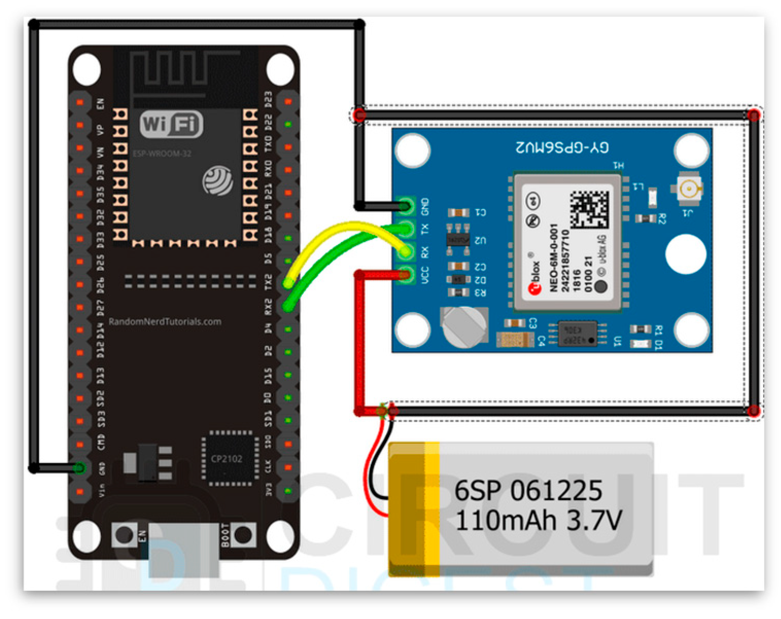
The GPS and GSM modules are powered by external batteries, while the ESP32 is powered by a PC through a USB. GPS Vin represents the ESP32’s VCC, and GPS GND represents its GND. In serial, ESP32 and SIM800L connect. We also need an Airtel 2G SIM card to send messages using the GSM module. With the ESP32 enabled, the system sends an SMS of the phone number with the Google Maps position. The system requires the GSM SIM800L to flash its LED every three seconds to indicate network connectivity. The application uses an ESP32, GSM SIM800L, and a GPS module. The NEO-6M GPS module’s 10 m sensitivity locates the user. SIM800L is used to communicate location data to other mobile phones. The NEO-6M GPS module, with a 10 m sensitivity, was chosen to pinpoint the user because the other options use Internet protocols, which may be unavailable. This module uses the SIM card 2G band to deliver data. The serial interface connects the SIM card and GPS module to the microcontroller. The hardware serial interface is used from the ESP32. Also, the programming of the microcontroller is performed over Arduino IDE, which provides the library required for the driver to fetch the data from the GPS module and SIM800L. SIM800L is power-sensitive, and fluctuations in the power may prevent it from connecting to the service provider. The code activates the GPS and SIM card modules. For location data, the SIM card must be connected to a nearby 2G service from the provider. Map systems like Google Maps can display location data sent through coordinates. The microcontroller may send a customized message and position information. For convenience, the microcontroller reset button sends data to a phone number. Additional GPS and SIM card module pins can be configured for various purposes. See
Figure 2,
Figure 3 and
Figure 4 too see connections.
3. Results and Discussion
The code activates both the SIM card and module. The SIM card needs to be connected to a nearby 2G SIM service offered by the SIM card service provider in order to relay the location data. Coordinates can be used to send the location data, which can subsequently be seen using map services like Google Maps. A customized message that has been programmed into the microcontroller can be delivered together with the location coordinates. Refer
Figure 5 and
Figure 6 for more details.
4. Conclusions
The design of a safety system based on GPS and GSM technologies is an efficient solution for tracking a location in the case of an emergency. The use of GPS technology enables accurate location tracking, while GSM technology provides the means to transmit this information to a remote monitoring station. Such a system could be beneficial in a variety of scenarios, including tracking the location of emergency responders, hikers, or other outdoor enthusiasts, as well as individuals in need of assistance. In addition, the use of such a system could potentially reduce the response time of emergency services, improving the chances of positive outcomes in emergency situations. Overall, it seems that a safety system based on GPS and GSM technologies could be an effective solution for location tracking in emergency situations, but careful consideration must be given to the design and implementation of such a system to ensure that it is reliable, secure, and effective in practice.
Author Contributions
Conceptualization, C.B., A.B., D.N., P.P., H.B. and O.D.; methodology, C.B., A.B., D.N., P.P., H.B. and O.D.; validation, S.K. and K.S.; investigation, P.P.; resources, H.B. and C.B.; data curation, P.P.; writing—original draft preparation, A.B., D.N. and O.D.; writing—review and editing, A.B. and O.D.; supervision, K.S. and S.K. All authors have read and agreed to the published version of the manuscript.
Funding
This research received no external funding.
Institutional Review Board Statement
Not applicable.
Informed Consent Statement
Not applicable.
Data Availability Statement
All the data used are made available in the present work.
Conflicts of Interest
The authors declare no conflicts of interest.
References
- Seenivasan, R.P. Vehicle Tracking System Using Internet of Things. Master’s Thesis, Pondicherry University, Pondicherry, India, 2018. [Google Scholar] [CrossRef]
- Garla, R. IoT based GPS location tracker using NodeMCU and GPS module. IJSART 2021, 7, 214. [Google Scholar]
- Barak, D.D.; Singh, K.; Ahlawat, P.; Sharma, H.K. Real Time Tracking System: An IoT Based Application. In Proceedings of the 5th International Conference on Next Generation Computing Technologies (NGCT-2019), Dehradun, India, 20–21 December 2019. [Google Scholar]
- Yellamma, P.; Kaza, L.C.; Putta, A.; Kodali, L.B. Object tracking system using IoT. Int. J. Innov. Technol. Explor. Eng. 2020, 9, 2278–3075. [Google Scholar]
| Disclaimer/Publisher’s Note: The statements, opinions and data contained in all publications are solely those of the individual author(s) and contributor(s) and not of MDPI and/or the editor(s). MDPI and/or the editor(s) disclaim responsibility for any injury to people or property resulting from any ideas, methods, instructions or products referred to in the content. |
© 2024 by the authors. Licensee MDPI, Basel, Switzerland. This article is an open access article distributed under the terms and conditions of the Creative Commons Attribution (CC BY) license (https://creativecommons.org/licenses/by/4.0/).


 ,
, 


