Proceeding Paper

Integrating Drone-Captured Sub-Catchment Topography with Multiphase CFD Modelling to Enhance Urban Stormwater Management †

1
School of Engineering, Tallinn University of Technology, Tallinn 19086, Estonia
2
School of Science, Tallinn University of Technology, Tallinn 19086, Estonia
*
Author to whom correspondence should be addressed.
Presented at the 3rd International Joint Conference on Water Distribution Systems Analysis & Computing and Control for the Water Industry (WDSA/CCWI 2024), Ferrara, Italy, 1–4 July 2024.
Eng. Proc. 2024, 69(1), 31; https://doi.org/10.3390/engproc2024069031
Published: 2 September 2024

Abstract

:
In this study, a drone-captured spatial data point cloud is used as input for creating a high-resolution modelling domain that accurately represents urban stormwater sub-catchments’ topography. The objective is to map possibilities, showcase the potential, and establish an in-house workflow that is as efficient as possible for the high-resolution modelling of stormwater runoff in urban sub-catchments, to provide input for improving urban stormwater management. The computational fluid dynamics model simulation results are compared to geographic information system-based analysis data and field observations, illustrating the benefits and limitations of the approach.

1. Introduction

Assessing and mitigating risks caused by cloudbursts in urban areas requires a comprehensive and versatile dataset, including data regarding the existing infrastructure, land use, and topography [1]. Concurrently, the need for high-resolution modelling of urban areas, including industrial areas, is increasing [2] due to different drivers and recommendations on policy [3]. Unmanned aerial system technologies, like drone surveys, are widely used in the construction sector to capture as-is building geometries [4]. However, their application in urban stormwater management is still a developing field [5]. If a drone survey is conducted to also include plot ground profiles it can provide input for carrying out risk assessment of pluvial flooding-induced damage to buildings by modelling overland flow but can be carried out as a stand-alone task for flood risk analysis or system design, too. The data acquisition precision, validated by uses in the construction sector, is relevant when considering that in urban sub-catchments, the overland flow path and regime depends on the terrain profile and urban space elements, such as speed control elements and curbstones. In this study, a drone flight ground elevation dataset is used as an input for creating a computational fluid dynamics (CFD) modelling domain of a physical urban sub-catchment to test the applicability of the CFD approach and determine suitable workflows for runoff modelling enhancement.

2. Materials and Methods
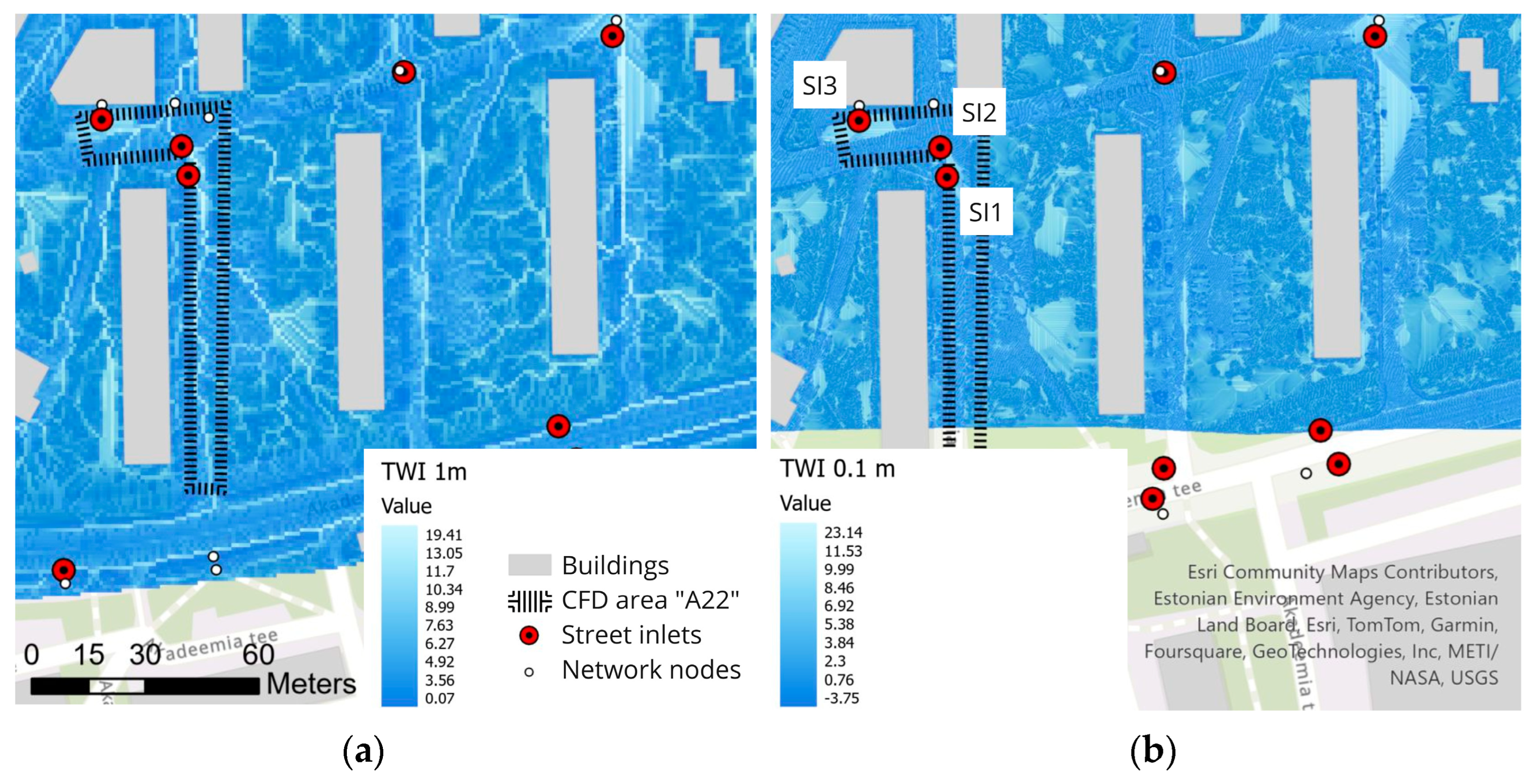
Since runoff in the urban environment is strongly influenced by various minor space elements like street curbs or traffic bumps, the digital elevation model (DEM; with resolutions of 1, 5, and 10 m) created based on aerial laser scanning (LiDAR) and available from the Land Board does not provide sufficient accuracy. Both LiDAR and photogrammetric aerial surveying can be performed with drones, with the latter providing higher resolution (point cloud 1–4 cm). In photogrammetry, a 3D dataset is generated from the 2D photo data recorded by the drone through the application of photogrammetry and image stitching algorithms, which presents the area and the dimensions of all the objects within the drone’s field of view (buildings, facilities, trees, bushes, vehicles, etc.). In this study, a drone survey was carried out on an area of 0.15 km2 and a point cloud with an average resolution of 1 cm × 1 cm was generated by the photogrammetry approach.
Before the point cloud could be used, point cloud filtering, including removing irrelevant objects and erroneous points, needed to be conducted. Furthermore, it was also necessary to optimize data volumes by removing so-called redundant points. The point cloud created by the survey resulted in a more or less uniform resolution throughout, with millions of points to represent a subdistrict landcover, necessitating extensive resources for data governance even before moving to the resource-intensive modelling. At the same time, the existence of flat surfaces was characteristic of the urban environment. In such areas, it was possible to reduce the resolution, i.e., to thin out the point cloud. This data processing method is suitable if the geometry of the houses is also included in further analysis. In this case, the walls of the houses could be represented in the model with sparse points, as opposed to areas with surface features that affect the flow paths.
The filtered point cloud was used to create a DEM with 0.1m pixel resolution and a stereolithography (STL) surface model with a varying resolution retaining all relevant surface features. The STL surface was used as an input for creating the computational domain geometry for CFD, with the STL forming the bottom boundary of the domain. Several domains were created of sub-areas with elements of interest (e.g., local slope, adjacent stormwater street inlets or embankments). The computational domain was discretized using a hybrid grid containing a blend of structured and unstructured grid areas. The snappyHexMesh utility from OpenFOAM, which creates the grid by snapping to triangulated surface geometries, was used to generate the mesh. The domain was discretized with different refinement combinations seeking the optimal solution with minimal skewness and non-orthogonality, cell size near the bottom boundary, and cell count. For the street-scale domains the grids compared varied within cell counts from order of magnitude of 1 to 6 million, and from larger plot and sub-district scales from 5 to 20 million.
In broad terms, two modelling objectives were sought: determination of flow paths around obstacles and over uneven slopes, including flow dynamics between adjacent stormwater street inlets on the street-scale, and ponding locations near building foundations at a larger scale. The overland water flow was simulated by applying a Volume of Fluid (VOF)-based method [6] where two fluids, assumed immiscible, Newtonian, and incompressible, are considered numerically as a single joint fluid. The VOF model’s implementation in OpenFOAM, the interFoam solver that has been systematically validated in several studies, e.g., [7], was applied. The solution was driven by an adjustable time-stepping approach based on the Courant number of the Courant–Friedrichs–Lewy (CFL) condition [8], which is calculated in the interFoam implementation at each iteration step both for the global domain and the interface. For the street-scale simulation, the constant flowrate inflow was set at a boundary at a relative higher altitude. The ponding studies were conducted by initiating the simulation with a relatively thin layer of water over the computational domain at the simulation start time that was then allowed to freely escape the domain at all vertical boundaries, set to atmospheric conditions.
As a reference, the topographic wetness index (TWI) was calculated for the study area. TWI can be used for urban flood risk assessment to create flood susceptibility maps and identify areas vulnerable to flooding. The TWI has been identified as an important factor in assessing flood sensitivity, along with other variables such as elevation, slope, rainfall, and land use/land cover, with higher values of TWI indicating areas where water is likely to accumulate during excessive precipitation. The TWI method has been found to be effective in identifying flooding points in urban areas, and it has been recommended as a method for adopting strategic measures to mitigate flood risks. It has been found, however, that when using fine resolution digital elevation models as the basis for TWI calculation, the results tend to become excessively fragmented [9].

3. Results

The TWI maps were created for two different DEM resolutions. Figure 1a depicts the TWI calculated on DEM with a resolution of 1 m × 1 m obtained from the Land Board and (b) shows TWI calculated on the DEM (resolution 0.1 m × 0.1 m) generated based on the drone survey. The water accumulation areas largely coincide between the different resolution solutions. However, the higher resolution version does not show flow paths, as can be seen on the lower (b).
CFD study area A22 depicted in Figure 1 is a street section approximately 100 m long on the longer branch and with a 1 m elevation difference between its boundaries. Figure 2 shows the section of the longer branch of the street area, with stormwater street inlet SI1 indicated. While the TWI with the coarser resolution indicates that the flow path is directly into the street inlet, the CFD model shows a meandering path down the street with the flow passing the inlet at the relatively low water depth. This behavior is also seen in field observations during a modest rain event, with flow into the street inlet starting after a critical ponding depth is reached at a low point across the street.

4. Discussion

While CFD simulations on large-scale urban catchments are not feasible due to unreasonable demands on computational resources, they are well-suited for conducting detailed analysis of specific complex sub-areas and providing insight into small engineered sub-catchments’ runoff dynamics. The CFD approach will likely not be a component of a decision support framework soon, but could be implemented in providing clarification and input for engineering software, such as the widely used EPA SWMM. Furthermore, for communicating urban flood risk, a realistic three-dimensional visual display achieved by robust particle-based CFD methods that do not compute all features of the fluid dynamics may be more suitable than detailed flood maps [10].
Herein, a more detailed (VOF) approach has been applied to provide inputs for improving stormwater runoff modelling. Concurrently, it must be noted that the sensitivity studies regarding e.g., resolution, turbulence modelling, and surface roughness definitions are still partially ongoing.

Author Contributions

Conceptualization, K.K., I.A., M.T. and N.K.; methodology, K.K. and I.P.; software, K.K. and I.P.; writing—original draft preparation, K.K. and I.P.; writing—review and editing, K.K., I.A., M.T. and N.K.; visualization, K.K.; funding acquisition, I.A. and M.T. All authors have read and agreed to the published version of the manuscript.

Funding

This research was funded by the European Commission, grant number Life 20 IPC/EE/000010 and by the Estonian Research Council, grant number PRG667.

Institutional Review Board Statement

Not applicable.

Informed Consent Statement

Not applicable.

Data Availability Statement

Parts of the data supporting the conclusions of this article may be made available by the authors on request. Restrictions apply to the availability of some of the data.

Acknowledgments

The authors acknowledge Republic of Estonia Land Board for their open access data, and Hades Geodeesia for preliminary photogrammetry data filtering. The simulations were partially carried out in the High Performance Computing Centre of Tallinn University of Technology.

Conflicts of Interest

The authors declare no conflicts of interest.

References

  1. Truu, M.; Annus, I.; Roosimägi, J.; Kändler, N.; Vassiljev, A.; Kaur, K. Integrated Decision Support System for Pluvial Flood-Resilient Spatial Planning in Urban Areas. Water 2021, 13, 3340. [Google Scholar] [CrossRef]
  2. Abily, M.; Duluc, C.M.; Faes, J.B.; Gourbesville, P. Performance Assessment of Modelling Tools for High Resolution Runoff Simulation over an Industrial Site. J. Hydroinform. 2013, 15, 1296–1311. [Google Scholar] [CrossRef]
  3. Stein, U.; Bueb, B.; Englund, A.; Elelman, R.; Amorsi, N.; Lombardo, F.; Corchero, A.; Brékine, A.; Lopez Aquillar, F.; Ferri, M. Digitalisation in the Water Sector. Recommendations for Policy Developments at EU Level; Publications Office of the European Union: Luxembourg, 2022; ISBN 978-92-95080-52-2. [Google Scholar] [CrossRef]
  4. Gilmour, L.; Stroulia, E. Ortho-Photogrammetry for Prefabricated Energy-Efficiency Retrofits. Automat. Constr. 2022, 134, 104082. [Google Scholar] [CrossRef]
  5. Whitman, J.B.; Perez, M.A.; Sturgill, R.E. NCHRP Synthesis 609: Use of Unmanned Aerial Systems for Inspection of Stormwater Best Management Practices; Transportation Research Board: Washington, DC, USA, 2023; ISBN 978-0-309-69874-0. [Google Scholar]
  6. Hirt, C.W.; Nichols, B.D. Volume of Fluid (VOF) Method for the Dynamics of Free Boundaries. J. Comput. Phys. 1981, 39, 201–225. [Google Scholar] [CrossRef]
  7. Deshpande, S.S.; Anumolu, L.; Trujillo, M.F. Evaluating the Performance of the Two-Phase Flow Solver interFoam. Comput. Sci. Discov. 2012, 5, 014016. [Google Scholar] [CrossRef]
  8. Courant, R.; Friedrichs, K.; Lewy, H. Über Die Partiellen Differenzengleichungen Der Mathematischen Physik. Math. Ann. 1928, 100, 32–74. [Google Scholar] [CrossRef]
  9. Altunel, A.O. The Effect of DEM Resolution on Topographic Wetness Index Calculation and Visualization: An Insight to the Hidden Danger Unraveled in Bozkurt in August, 2021. Int. J. Eng. Geosci. 2023, 8, 165–172. [Google Scholar] [CrossRef]
  10. Winkler, D.; Zischg, J.; Rauch, W. Virtual Reality in Urban Water Management: Communicating Urban Flooding with Particle-Based CFD Simulations. Water Sci. Technol. 2018, 77, 518–524. [Google Scholar] [CrossRef] [PubMed]
Figure 1. TWI for different resolution elevation data, stormwater street inlets SI1-SI3 are within an area (A22) modelled with the CFD approach. (a) 1 m × 1 m raster; (b) 0.1 m × 0.1 m raster.
Engproc 69 00031 g001
Figure 2. (a) Image of the street area that was modeled with the CFD approach; (b) section of modelled area A22, with streetlight locations and building feature edges shown for reference.
Engproc 69 00031 g002
Disclaimer/Publisher’s Note: The statements, opinions and data contained in all publications are solely those of the individual author(s) and contributor(s) and not of MDPI and/or the editor(s). MDPI and/or the editor(s) disclaim responsibility for any injury to people or property resulting from any ideas, methods, instructions or products referred to in the content.

