Abstract
Flood incidents occur annually in Taman Negara Endau Rompin Selai Bekok due to continuous substantial rains during the rainy period. The absence of a structured flood tracking and detection system limits effective information dissemination regarding flooding to the public; currently, visitors are only informed at office counters. This inefficient conventional method should be upgraded to a real time flood monitoring and alert system utilizing Internet of things (IoT) technology. UTHM personnel have requested the development of an easily accessible flood detection system via tablets or smartphones to efficiently relay flood information to visitors. Consequently, a flood detection system called “Floodwatch” was developed. The prototype provides live water level readings, air temperature, humidity, and flood images to users. The prototype has undergone rigorous testing to ensure stability, consistency, and accuracy, enabling its effective utilization. The Floodwatch system aims to enhance safety and awareness during flood events in the Taman Negara Endau Rompin Selai Bekok area.
1. Introduction
Industrial Revolution 4.0 has facilitated the development of smart flood detection systems around the globe. These systems use advanced technology to monitor floods and expand rapidly. With the advancement of communication technology, such as the internet, people can now monitor and control devices from a far. As a result, systems utilizing IoT are increasingly prevalent [1,2,3,4], encompassing flood detection systems as well. An IoT-based system was developed for initial flood discovery and avoidance [1]. The system measures several parameters, including humidity, temperature, and water flow. Additionally, it tracks the level of the water in the dam. The sensors in the unit unceasingly monitor these factors, enabling swift action based on the detected data. This module activates an alert system if the data exceed the predefined threshold. The DHT11 sensor monitors temperature and humidity, while HCSR04 uses ultrasonic range to calculate object distance. The Arduino Uno receives data from all of these sensors and processes it. A smart early flood monitoring system using IoT was proposed by [2]. The system monitors various natural phenomena to predict floods, allowing the public to prepare in advance and minimize potential damage. The system tracks environmental factors such as temperature, humidity, the water rise rate, and water level. Flood forecast is performed using IoT-enabled sensor data and machine learning algorithms. The researchers in [3] implemented a system using sensors to detect humidity, temperature, and water levels at each stage. The detected values from the sensor are processed using a PIC microcontroller and transmitted via Wi-Fi segment. The system instantly uploads and broadcasts sensor values via the cloud. The decision tree algorithm is implemented to carry out the classification method. A surveillance video-based flood monitoring system was introduced by [4], designed to notify people about occurring tragedy. This method does not need any of the currently used water level measuring techniques, such as suitable locations and structures for setting up the rulers and various sensors. It provides flood warning information to disaster relief units and the general public, in order to take necessary precautionary actions for the disaster which has occurred.
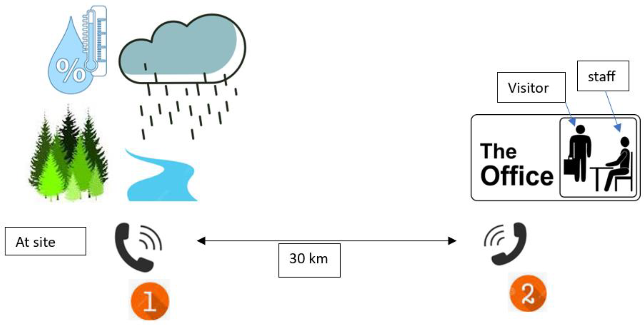
One such system is being implemented in Taman Negara Endau Rompin (Selai) to improve flood management [5]. This area faces yearly floods due to heavy rain during the monsoon season. However, there is currently no efficient flood monitoring system in place. This leads to ineffective communication with visitors, who are often unaware of the flooding until they reach the park office and find it closed. To address this issue, live flood tracking and announcement systems using IoT are being implemented. These systems aim to provide accurate flood data to park authorities and visitors. The current flood management system is manual, as shown in Figure 1. If a flood occurs, visitors in the river area must call the office located 30 km away. It means that if no one is present in the flooded area, the office will remain unaware of the flood. By implementing the FloodWatch system shown in Figure 2, authorities can receive real time alerts about flooded areas. Simultaneously, visitors can also be notified of the flood occurrence.
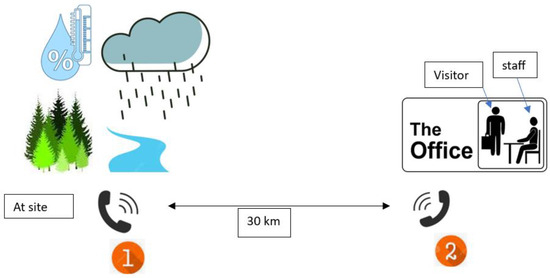
Figure 1.
The current method of the flood management system.
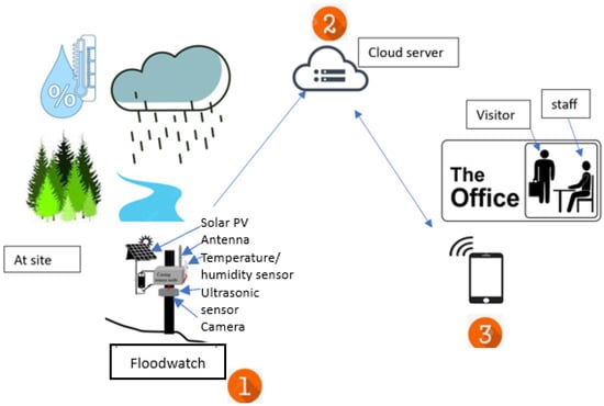
Figure 2.
The proposed system.
Floods have damaged roads leading to the park and caused erosion in areas like Lubuk Merekek. The area is basically a popular outdoor destination in Johor, Malaysia, known for activities like camping and waterfall treks. Factors contributing to flooding in the area include excessive rainfall and shallow rivers. Efforts are being made to develop efficient flood detection systems using various technologies like water level detectors, cameras, ultrasonic sensors, and radar. These systems aim to provide early warnings for river and road floods. Factors like sensor type, data display method, and power supply are important considerations. IoT-based systems were successfully installed in the study area, equipped with notification messages and alarm sirens. These systems consist of remote terminal units (RTUs), sensor arms, and IoT networks. They provide live flood data and are easy to install and access. Although these systems have achieved successes, their security features are often neglected. For instance, some systems do not include measures to prevent theft.
Various flood monitoring and detection systems have been established and deployed in multiple locations. They involve site visits, flood location identification, network coverage testing, system design, construction, testing, and installation. Various techniques for detecting flood levels have been introduced, such as ultrasonic sensors, rain sensors, GPS modules, and AI optimization. These systems aim to provide accurate flood data and early warnings to users. The flood detection system developed for Taman Negara Endau Rompin (Selai) provides river water level data, humidity and temperature data, and flood pictures. Lubuk Merekek is selected for installation of the system due to available infrastructure and less risk of interference. Monitoring floods in this area is challenging due to fast moving water. Patrolling during heavy rain is inefficient due to labor shortages and remote locations. Therefore, a system capable of remote flood detection is needed. The flood detection system in this project uses ultrasonic sensors and a raspberry-pi microcontroller to provide live flood data via the 4G network. It contains an RTU module, sensors, and a cloud server for data transmission. A detailed explanation on the preliminary work is reported in reference [5]. This project aims to develop a cost-effective flood detection system that can provide accurate and live information to park staff and visitors. The prototype has undergone testing and has been confirmed for accuracy.
2. FloodWatch Design
The RTU FloodWatch unit was built using a single phase outdoor metal box that is strong enough to handle any weather condition, including absorbing changes in external and internal weather such as heat and rain. This can help reduce the environmental impact of forest conditions that can affect system operations. Floodwatch offers live monitoring of flood levels, flood images, air temperature, and humidity. Internal components include battery, solar charger controllers, PCB boards, microcontrollers, and safety circuits. Additionally, holes for cable paths for antennas, cameras, and sensors are positioned appropriately to enable the system to operate more effectively. Camera and sensor placements are carefully designed for optimum operation, protecting components from damage, especially during bad weather, and preventing theft. Rainproof, contactless ultrasonic sensors are employed to gauge river water levels, and RS485 sensors are chosen to assess the ambient air temperature and humidity. Digital cameras are used to capture flood images. The compact and versatile Raspberry Pi is chosen as the microcontroller, offering various functions. The system uses the Celcom 4G network to transmit the data and flood pictures to the cloud server. Closed lead acid batteries are used as the primary power source and can be rechargeable. This battery type is chosen for its practicality, durability, and cost-effectiveness. These batteries produce a 12 V output voltage with a capacity of 12 Ah. As a secondary power source, a 30 W solar panel with an 18 V output voltage is used. Figure 3 depicts the demo unit developed. Important information regarding prototype design, RTUs, and initial test findings are reported in reference [5].
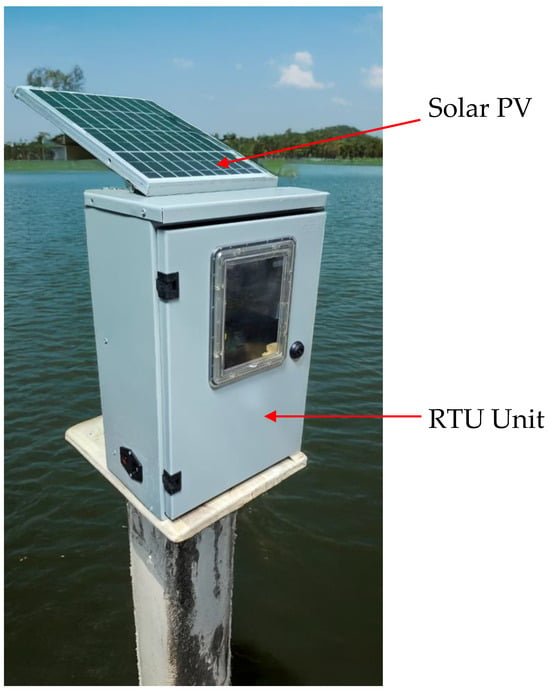
Figure 3.
Demo set.
The RTU can be powered by battery or a photovoltaic solar system. The RTU is connected to the cloud server using a wireless router. From here, the flood image, water level, temperature, humidity, and notification message can be obtained from the cloud server using a smartphone. The user will request the image. The server will request the ID and request the camera module via MQTT version 2 to map the picture. Then, the camera module will upload the image to the server via http and transmit it to the Telegram channel. Otherwise, the data will be collected and transmitted to the cloud server. If the water level is critical, then the notification is sent to the Telegram. Otherwise, the process will be repeated.
3. Results and Discussion
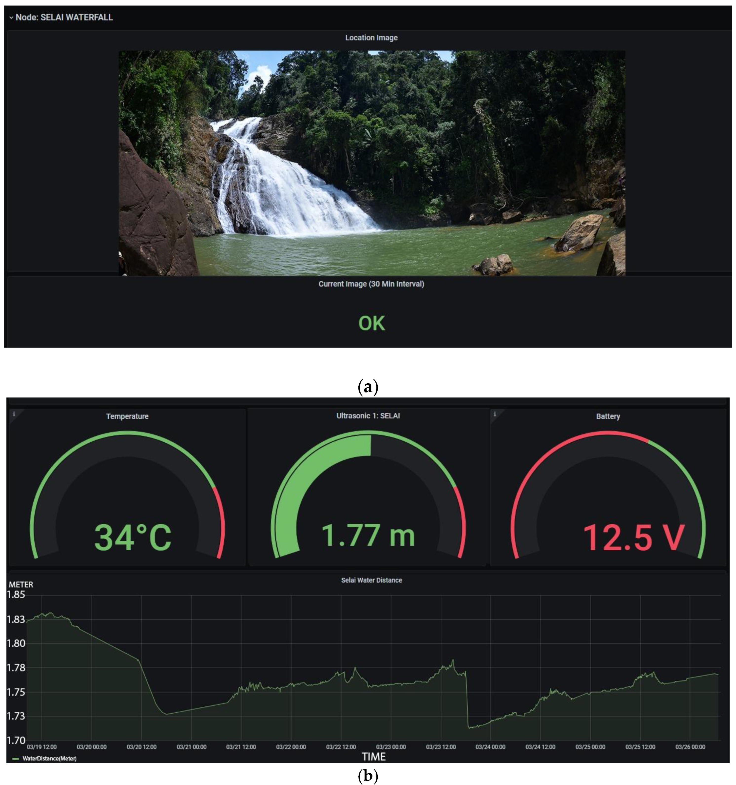
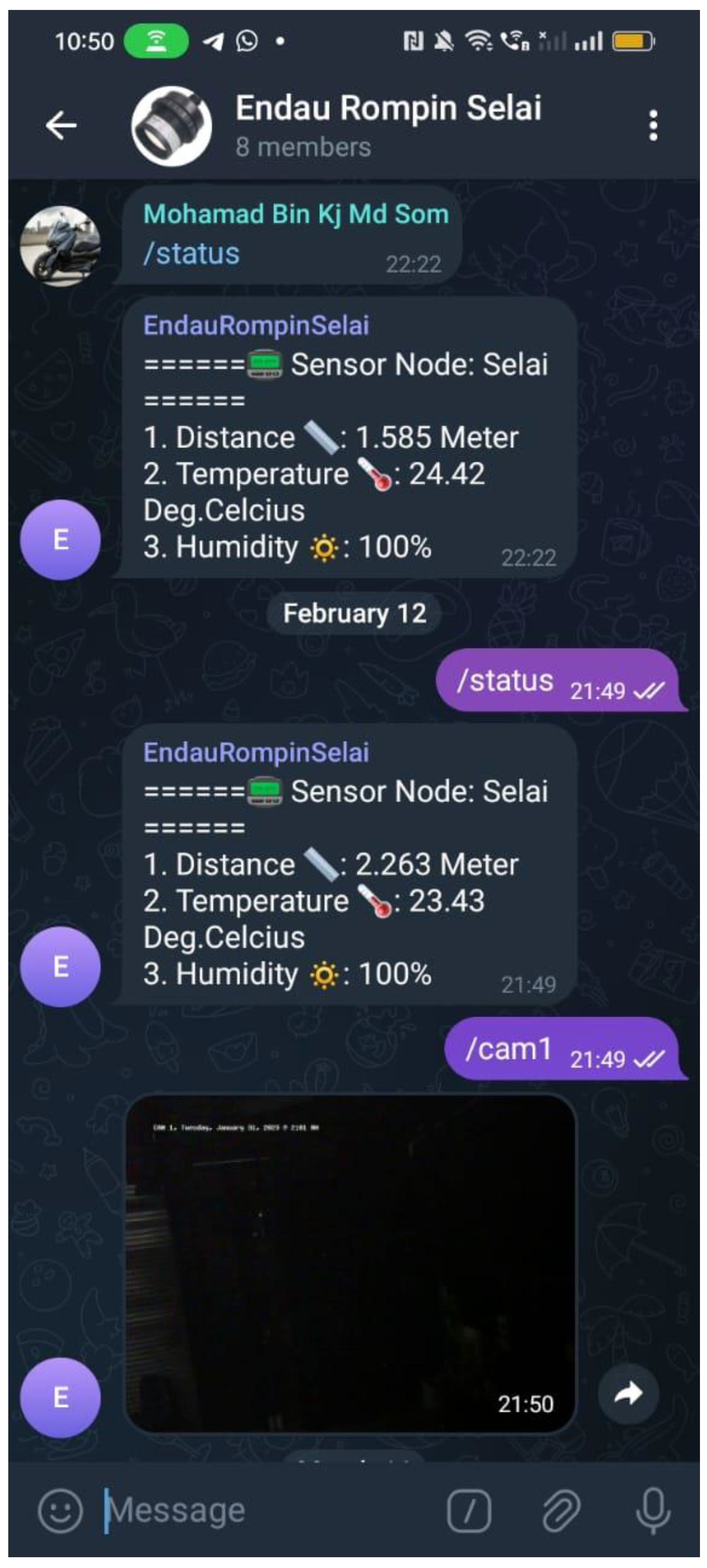
Users can access the system by logging into iot.uthm.edu.my/monitoring from a smartphone. Users can view flood-related data such as water levels, images of the flood, temperature, and humidity from sensors and cameras. This information is saved on a cloud server. The system works well, providing live flood data to users. Figure 4a shows a picture from a camera. Users have the capability to request that the system activate the camera and upload the picture to the website. Both water level readings and camera images are vital for authorities. In Figure 4b, the water level, temperature, and humidity readings are displayed. Continuous river water level readings are shown in the diagram ranging from 1.73 m to 1.84 m. Figure 5 illustrates the Telegram channel displaying real time outputs from the system, including distance, temperature, and humidity measurements. The user is required to be in the authorized Telegram cluster to be able to monitor the system, as depicted in Figure 5. The image of the flood will be obtained in the channel by entering/cam. Also, the status of the flood will be demonstrated in the channel by typing/reading. Overall, the developed system provides an efficient way to monitor flood data readings in real time using a smartphone.
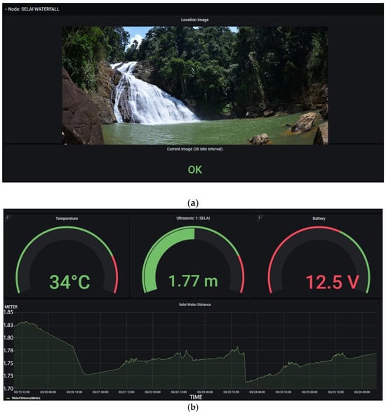
Figure 4.
(a) Image from VGA camera; (b) water level distribution.
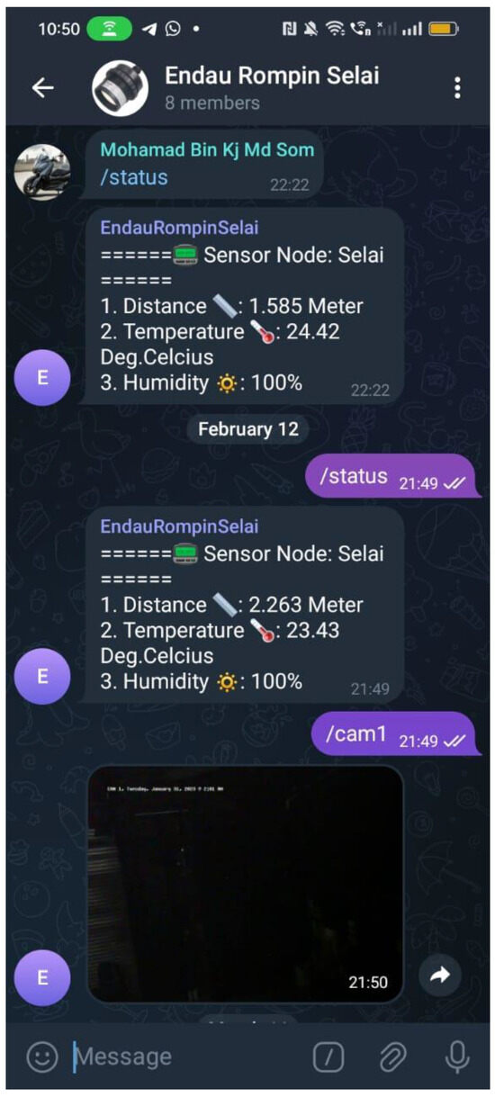
Figure 5.
Telegram channel.
4. Conclusions
In conclusion, the system, established in November 2022, has undergone continuous testing since its inception. It consistently collects and transmits flood data to users reliably. With Grafana software (V 7.5.2), users can monitor the system and request flood pictures. This low-cost system is anticipated to operate effectively and securely, offering users flood data and flood pictures. Furthermore, the readings of river water level, humidity, and temperature can be displayed on smartphones for more effective monitoring purposes in real time.
Author Contributions
Conceptualization, K.N.R.; project administration, M.N.D.; formal analysis, S.A.H.; software, M.M.S.; investigation, M.S.Z.; methodology, M.H.S.; methodology, A.Y.; data curation, W.M.U.; validation, A.S.; resources, M.I.; original draft preparation, N.A.Y.; review and editing, M.M. All authors have read and agreed to the published version of the manuscript.
Funding
This research is funded by the Universiti Tun Hussein Onn Malaysia (UTHM) through Geran TIER1 Q356, Geran Kontrak Q005, Ministry of Higher Education Malaysia through Fundamental Research Grant Scheme (FRGS/1/2019/TK04/UTHM/02/8) and Johor National Park Corporation.
Institutional Review Board Statement
Not applicable.
Informed Consent Statement
Not applicable.
Data Availability Statement
The data presented in this study are available on request from the corresponding author due to privacy.
Acknowledgments
Recognition and appreciation are given to the authorities in Endau who have given permission to conduct this research and subsequently gave full cooperation in making this project a success.
Conflicts of Interest
The authors declare no conflict of interest.
References
- Deowan, M.E.; Haque, S.; Islam, J.; Hanjalayeamin, M.; Islam, M.T.; Meghla, R.T. Smart early flood monitoring system using IoT. In Proceedings of the 2022 14th Seminar on Power Electronics and Control (SEPOC), Santa Maria, Brazil, 12–15 November 2022; pp. 1–6. [Google Scholar] [CrossRef]
- Charaan, R.M.D.; Shobana, J.; Krishnamoorthy, P.; Princy, B.A.; Abinaya, R.J.; Murugesan, K. Enhancement of IoT based Flood Detection and Prevention using Arduino UNO with WiFi Module. In Proceedings of the 2023 9th International Conference on Advanced Computing and Communication Systems (ICACCS), Coimbatore, India, 17–18 March 2023; pp. 2290–2294. [Google Scholar] [CrossRef]
- Vinothini, K.; Jayanthy, S. IoT based flood detection and notification system using decision tree algorithm. In Proceedings of the 2019 International Conference on Intelligent Computing and Control Systems (ICCS), Madurai, India, 15–17 May 2019; pp. 1481–1486. [Google Scholar] [CrossRef]
- Menon, K.P.; Kala, L. Video surveillance system for realtime flood detection and mobile app for flood alert. In Proceedings of the 2017 International Conference on Computing Methodologies and Communication (ICCMC), Erode, India, 18–19 July 2017; pp. 515–519. [Google Scholar] [CrossRef]
- Hamzah, S.A.; Dalimun, M.N.; Som, M.M.; Zainal, M.S.; Ramli, K.N.; Sanusi, M.H.; Yusop, A.; Ishak, M.; Rahman, R.A.; Sidek, A.; et al. Flood Level Detection System using Ultra Sonic and ESP32 Camera: Preliminary Results. In Proceedings of the International Conference on Electrical and Electronic Engineering 2023 (ICON3E2023), Putrajaya, Malaysia, 28–29 August 2023; pp. 1–12. [Google Scholar]


Disclaimer/Publisher’s Note: The statements, opinions and data contained in all publications are solely those of the individual author(s) and contributor(s) and not of MDPI and/or the editor(s). MDPI and/or the editor(s) disclaim responsibility for any injury to people or property resulting from any ideas, methods, instructions or products referred to in the content. |
© 2025 by the authors. Licensee MDPI, Basel, Switzerland. This article is an open access article distributed under the terms and conditions of the Creative Commons Attribution (CC BY) license (https://creativecommons.org/licenses/by/4.0/).