Determination of the Impact of Urbanization in Istanbul Northern Forests by Remote Sensing †
Abstract
:1. Introduction
2. Materials and Methods
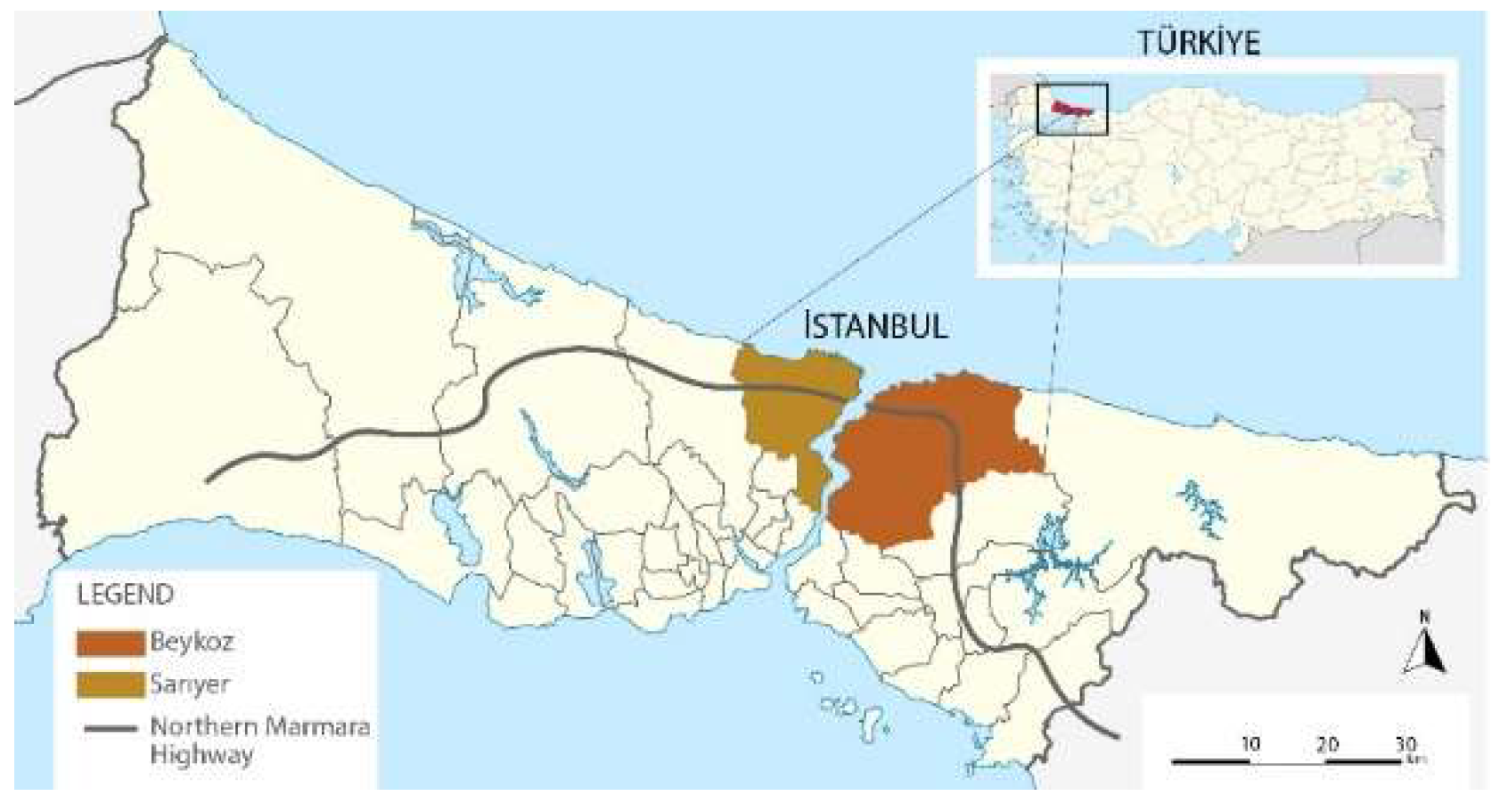
2.1. Study Area and Data
2.2. Object-Based Image Classification
2.3. Accuracy Assessment
2.4. Landscape Metrics
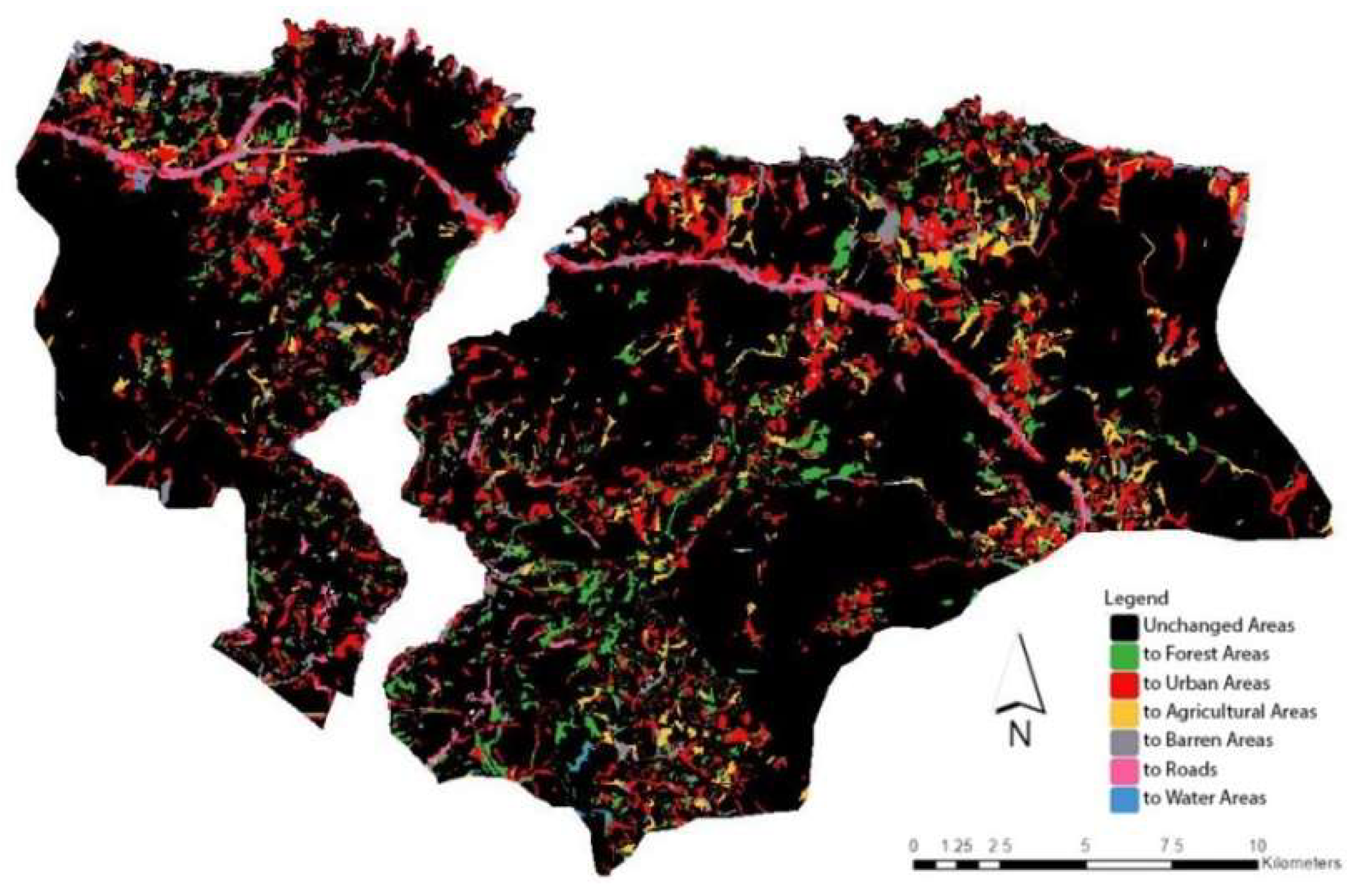
3. Result and Discussion
Author Contributions
Funding
Institutional Review Board Statement
Informed Consent Statement
Data Availability Statement
Conflicts of Interest
References
- Aksu, G. Analysis of Landscape Changes: A Case Study in Istanbul Sarıyer. Ph.D. Thesis, Istanbul University, Istanbul, Turkey, November 2012. [Google Scholar]
- Brockerhoff, E.G.; Jactel, H.; Parrotta, J.A.; Quine, C.P.; Sayer, J. Plantation forests and biodiversity: Oxymoron or opportunity? Biodivers. Conserv. 2008, 17, 925–951. [Google Scholar] [CrossRef]
- Bain, D.J.; Brush, G.S. Placing the pieces: Reconstructing the original property mosaic in a warrant and patent watershed. Landsc. Ecol. 2004, 19, 843–856. [Google Scholar] [CrossRef]
- Li, H.; Peng, J.; Yanxu, L.; Yina, H. Urbanization impact on landscape patterns in Beijing City, China: A spatial heterogeneity perspective. Ecol. Indic. 2017, 82, 50–60. [Google Scholar] [CrossRef]
- Han, X.; Chen, X.; Feng, L. Four decades of winter wetland changes in Poyang Lake based on Landsat observations between 1973 and 2013. Remote Sens. Environ. 2015, 156, 426–437. [Google Scholar] [CrossRef]
- Algancı, U. Determination of Land Cover Changes with Multi-temporal Landsat 8 Satellite Images: A Case Study of Istanbul. Harita Dergisi. 2018, 160, 24–33. [Google Scholar]
- Jiang, N.; Zhang, J.X.; Li, H.T.; Lin, X.G. Object-oriented buinding extraction by DSM and very high-resolution orthoimages. The International Archives of the Photogrammetry. Remote Sens. Spat. Inf. Sci. 2008, 37, 441–446. [Google Scholar]
- Wahyudi, A.; Liu, Y.; Corcoran, J. Combining Landsat and landscape metrics to analyze large-scale urban land cover change: A case study in the Jakarta Metropolitan Area. J. Spat. Sci. 2019, 64, 515–534. [Google Scholar] [CrossRef]
- McGarigal, K. Models of Landscape Structure; Lecture Notes; University of Massachusetts: Amherst, MA, USA, 2001; Chapter 7. [Google Scholar]
- Alay, A.M. Investigation of Land Use-Land Cover Change, and Modeling the Landscape Change of Sariyer, Istanbul; Institute of Science and Technology, İstanbul Technical University: İstanbul, Turkey, 2016. [Google Scholar]
- Sertel, E.; Topaloglu, H.; Sallı, B.; Algan, I.; Aksu, G. Comparison of Landscape Metrics for Three Different Level Land Cover/Land Use Maps. Int. J. Geo-Inf. 2018, 7, 408. [Google Scholar] [CrossRef] [Green Version]
- Benliay, A.; Yıldırım, E. Use of Landscape Metrics in Landscape Planning Studies. Türk Bilimsel Derlemeler Derg. 2013, 6, 7–11. [Google Scholar]


| Years | Image Layer Weights (R-G-B-NIR-SWIR1-SWIR2) | Scale Parameter | Shape/Color | Compactness/Smoothness |
|---|---|---|---|---|
| 2009 | 1,1,1,2,1,1 | 20 | 0.8/0.2 | 0.6/0.4 |
| 2019 | 1,1,1,2,1,1 | 20 | 0.8/0.2 | 0.6/0.4 |
| Features for NN | Explanation |
|---|---|
| NDVI (Normalized Difference Vegetation Index) | To determine the vegetation density on the earth; NDVI = (NIR − RED)/(NIR + RED) |
| MNDWI (Modified Normalized Difference Water Index) | To determine the water areas on the earth; MNDWI = (GREEN − SWIR1)/(GREEN + SWIR1) |
| NDBI (Normalized Difference Built-up Index) | To determine the built areas on the earth; NDBI = (SWIR1 − NIR)/(SWIR1 + NIR) |
| Brightness | It calculates the average values of the objects in the image in all bands. |
| Length/Width | It determines the ratio of the lengths to the widths of the objects in the image. |
| Name | Abbreviation | Formulas | Description |
|---|---|---|---|
| Aggregation Index (Dispersion Interspersion Metric) | AI | (100) 0 ≤ AI ≤ 100 | It is used to measure the degree of clumping of patches. |
| Edge Density (Edge Metric) | ED | (10,000) ED ≥ 0, limitless | Edge density of all patches of the class |
| Largest Patch Index (Area Metric) | LPI | (100) 0 < LPI ≤ 100 | The ratio of the largest patch in the class to the class |
| Patch Density (Subdivision Metric) | PD | (10,000) (100) PD > 0, constrained by cell size. | It shows the distribution and fragmentation of cells by patch type. |
| Classes | 2009 | 2019 | ||
|---|---|---|---|---|
| PA (%) | UA (%) | PA (%) | UA (%) | |
| Water | 84 | 90 | 96 | 90 |
| Forest Areas | 92 | 98 | 94 | 97 |
| Urban Areas | 97 | 95 | 89 | 87 |
| Agricultural Areas | 94 | 82 | 89 | 89 |
| Barren Areas | 81 | 84 | 76 | 76 |
| Roads | 86 | 83 | 82 | 80 |
| 2009 | 2019 | |||
| Overall Accuracy | 91% | 89% | ||
| Kappa Ratio | 89% | 86% | ||
| Classes | 2009 | 2019 | Change Rate | ||
|---|---|---|---|---|---|
| Area/km2 | Percentage/% | Area/km2 | Percentage/% | % | |
| Water | 4.99 | 0.8 | 3.99 | 0.8 | - |
| Forest Areas | 317.85 | 73.2 | 293.98 | 67.3 | −5.9 |
| Urban Areas | 88.63 | 20.1 | 109.67 | 24.2 | +4.1 |
| Roads | 1.42 | 0.37 | 5.79 | 1.3 | +0.93 |
| Barren Areas | 1.82 | 0.33 | 7.27 | 2.6 | +2.27 |
| Agricultural Areas | 22.72 | 5.2 | 16.73 | 3.8 | −1.4 |
| TOTAL | 437.43 | 100 | 437.43 | 100 | 0 |
| Metrics | Units | Forest | Urban Areas | Roads | Barren | Agricultural Area | Water |
|---|---|---|---|---|---|---|---|
| 2009–2019 | 2009–2019 | 2009–2019 | 2009–2019 | 2009–2019 | 2009–2019 | ||
| PD | patch/ha | 0.38–0.49 | 0.77–1.17 | 0.07–0.21 | 0.3–0.64 | 0.91–0.63 | 1.18–1.50 |
| AI | % | 96.8–95.7 | 89.6–87.7 | 67.8–73.7 | 69.0–73.3 | 80.8–78.9 | 66.5–60.9 |
| ED | m/ha | 31.3–38.5 | 28.0–40.7 | 1.43–4.72 | 1.66–6.02 | 13.5–10.9 | 3.67–3.49 |
| LPI | % | 45.8–40.3 | 6.64–5.18 | 0.05–0.15 | 0.04–0.05 | 0.17–0.15 | 0.13–0.13 |
Publisher’s Note: MDPI stays neutral with regard to jurisdictional claims in published maps and institutional affiliations. |
© 2022 by the authors. Licensee MDPI, Basel, Switzerland. This article is an open access article distributed under the terms and conditions of the Creative Commons Attribution (CC BY) license (https://creativecommons.org/licenses/by/4.0/).
Share and Cite
Sarıbaş, B.; Bektaş Balçık, F. Determination of the Impact of Urbanization in Istanbul Northern Forests by Remote Sensing. Environ. Sci. Proc. 2022, 22, 57. https://doi.org/10.3390/IECF2022-13059
Sarıbaş B, Bektaş Balçık F. Determination of the Impact of Urbanization in Istanbul Northern Forests by Remote Sensing. Environmental Sciences Proceedings. 2022; 22(1):57. https://doi.org/10.3390/IECF2022-13059
Chicago/Turabian StyleSarıbaş, Büşra, and Filiz Bektaş Balçık. 2022. "Determination of the Impact of Urbanization in Istanbul Northern Forests by Remote Sensing" Environmental Sciences Proceedings 22, no. 1: 57. https://doi.org/10.3390/IECF2022-13059
APA StyleSarıbaş, B., & Bektaş Balçık, F. (2022). Determination of the Impact of Urbanization in Istanbul Northern Forests by Remote Sensing. Environmental Sciences Proceedings, 22(1), 57. https://doi.org/10.3390/IECF2022-13059


