


Environ. Earth Sci. Proc. 2025, 35(1), 69; https://doi.org/10.3390/eesp2025035069 - 9 Oct 2025
Abstract
►
Show Figures
Etesian winds, the characteristic summer winds over large parts of Greece and the eastern Mediterranean, can cause coastal upwelling, especially over the eastern Aegean. The question that many studies address is whether these northern winds can cause upwelling processes that alter not only
[...] Read more.
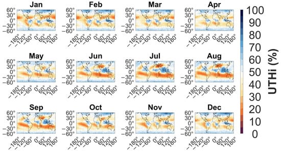
Etesian winds, the characteristic summer winds over large parts of Greece and the eastern Mediterranean, can cause coastal upwelling, especially over the eastern Aegean. The question that many studies address is whether these northern winds can cause upwelling processes that alter not only sea surface temperature but also chlorophyll concentrations, which are indicative of phytoplankton growth and overall ocean health. The present study is an effort to investigate the above matter over the eastern Aegean, from Lesvos to Ikaria and Samos islands, on a monthly basis, based on all the available satellite chlorophyll data up to now.
Full article

Figure 1


