Next Article in Journal
Satellite-Derived Estimates of Suspended CaCO3 Mud Concentrations from the West Florida Shelf Induced by Hurricane Ian
Previous Article in Journal
CoastSnap Valparaíso Region: An Experience of Citizen Science in Chile
 
 
Please note that, as of 4 December 2024, Environmental Sciences Proceedings has been renamed to Environmental and Earth Sciences Proceedings and is now published here.
Proceeding Paper

Pléiades Neo-Derived Bathymetry in Coastal Temperate Waters: The Case Study of Bay of Saint-Malo †

1
Coastal GeoEcological Lab, Ecole Pratique des Hautes Etudes, PSL University, 35800 Dinard, France
2
UMR BOREA (MNHN, CNRS, SU, IRD, UCN, UA), 35800 Dinard, France
*
Author to whom correspondence should be addressed.
Presented at the 5th International Electronic Conference on Remote Sensing, 7–21 November 2023; Available online: https://ecrs2023.sciforum.net/
Environ. Sci. Proc. 2024, 29(1), 68; https://doi.org/10.3390/ECRS2023-16366
Published: 11 December 2023
(This article belongs to the Proceedings of ECRS 2023)

Abstract

:
Satellite-derived bathymetry is increasingly attracting stakeholders’ attention tasked with remote and/or shallow depths, given its affordability compared to airborne lidar and waterborne sonar surveys. The 6-band 1.2 m Pléiades Neo (PNEO) multispectral imagery has not yet been evaluated for such a purpose. The contribution of the novel PNEO bands to the depth retrieval was assessed over unclear coastal seawaters (0.2 m−1 of vertical light attenuation in the bay of Saint-Malo, France). The relevance of the radiometric level was also tested: top-of-atmosphere (TOA) digital number (DN), TOA radiance, TOA reflectance, bottom-of-atmosphere (BOA) maritime-modeled reflectance, and BOA tropospheric-modeled reflectance. The lidar response, ranging from 0 to 20 m depth, was stratified by 90 random samples per bathymetric slice of 1 m. The model was based on an easy-to-transfer neural network (one hidden layer and three neurons). The best predictions, reaching R2test of 0.81, were equally obtained for the full PNEO dataset at TOA DN, radiance, and reflectance. For both BOA full-dataset products, the results were slightly less satisfactory: R2test of 0.75 (maritime) and 0.76 (tropospheric).

1. Introduction

Despite the growing interest in seabed mapping in the context of sea level rise and storm intensification, only 25% of the global bathymetry has been surveyed using reliable technologies such as sonar or lidar [1]. This considerable gap is primarily driven by the high cost of associated waterborne and airborne campaigns [2]. Consequently, satellite-derived bathymetry has thrived in recent decades, given its affordability enhanced by its ongoing gain in radiometric, spatial, spectral, and temporal resolutions [3,4].
Very high spatial resolution (VHSR) sensors provided with multispectral imagery have raised interest from coastal scientists and managers given the successful bathymetry retrieval down to 30 m in very clear waters (South Pacific) using WorldView-2 imagery [5] or to 10 m in chlorophyll-laden temperate waters (Channel Sea) using WorldView-3 imagery [6]. As a new flagship of the VHSR spaceborne sensor, the Pléiades Neo (PNEO) sensor leverages six bands: one deep blue, three visible, one red edge, and one infrared, provided with a 1.2 m pixel size. This new sensor thus outperforms the Pléiades-1 multispectral imagery endowed with four bands (three visible and one infrared) at a 2 m pixel size.
This study aims to innovatively quantify the contribution of the novel bands of the PNEO to bathymetry retrieval over optically challenging coastal seawaters (Channel Sea, 0.2 m−1 of vertical light attenuation) in the bay of Saint-Malo [7]. The importance of the level of the radiometric correction was tested based on the lidar bathymetry predicted by a shallow neural network (one hidden layer and three neurons).

2. Methodology

2.1. Study Site

The study site is located within the bay of Saint-Malo (48°40′ N 2°4′10″ W; Brittany, France), featuring a diversity of depths (ranging from the 0 m shoreline to the 20 m channel) and benthic albedos (mud, sand, gravel, pebble, boulder, rock) bathed by a megatidal regime (Figure 1).

2.2. Satellite Imagery

2.2.1. Pléiades Neo Sensor

The spaceborne mission was ensured by the PNEO 4 sensor that was launched on 16 August 2021 from Kourou (French Guyana). Our imagery was collected from a 620 km orbit on 7 December 2022 at 11 h 12 min 48 s UTC. This sensor collects deep blue (400–450 nm), blue (450–520 nm), green (530–590 nm), red (620–690 nm), red edge (700–750 nm), and near-infrared (770–880 nm) bands at 1.2 m spatial and 12-bit radiometric resolutions (Table 1).

2.2.2. Imagery Processing

The PNEO 4 imagery underwent a series of corrections prior to being further analyzed. First, the imagery was orthorectified in the RGF93 datum, projected with Lambert 93 along with the IGN69 vertical reference, based on RPC geometry metadata. Second, the resulting imagery was radiometrically corrected at five various levels using PNEO-4 spectral sensitivity: top-of-atmosphere (TOA) digital number (DN), TOA radiance, TOA reflectance, bottom-of-atmosphere (BOA) maritime reflectance, and BOA tropospheric reflectance (see FLAASH modeling). Third, the by-products were spatially subsetted on a transitional area perpendicular to the shoreline, providing a wide diversity of depths and albedos (Figure 1).

2.3. Lidar Topobathymetry

2.3.1. HawkEye 3

The depth response was derived from an airborne topobathymetric lidar carried out in May–July 2018 over the bay of Saint-Malo by the French Navy (Shom) using a Leica HawkEye 3 system, acquiring soundings with at least 4 points/m2 until 25 m water depth [7].

2.3.2. Lidar Processing

The WGS84 point cloud was rasterized at 1.2 m in the RGF93–Lambert 93–IGN69 geodesy in order to match the PNEO spatial dimensions and resolution (Figure 2).

2.4. Neural Network Modelling

The bathymetry retrieval relied on neural network modeling, whose response was embodied by the lidar response, and the predictors corresponded to the PNEO spectral bands.
For the sake of transferability, a shallow neural network modeler was developed and built from one layer and three neurons using hyperbolic tangent activation functions [8].
The lidar response was sliced at 1 m lag across the 20 m range and then randomly sampled with 90 virtual stations in order to well balance the statistical modeling. By equally dividing the 90 stations, 30 were randomly used for training, validation, and test data.

3. Results and Discussion

3.1. Spectral Contribution

The novel PNEO bands, namely deep blue and red edges, were compared with the reference blue–green–red–near-infrared (BGRIR) findings (R2test = 0.73). Averagely, the blue replacement by the deep blue increased results by 0.01; the addition of the deep blue increased by 0.02; and the addition of the deep blue and red edge increased by 0.06.

3.2. Radiometric Level

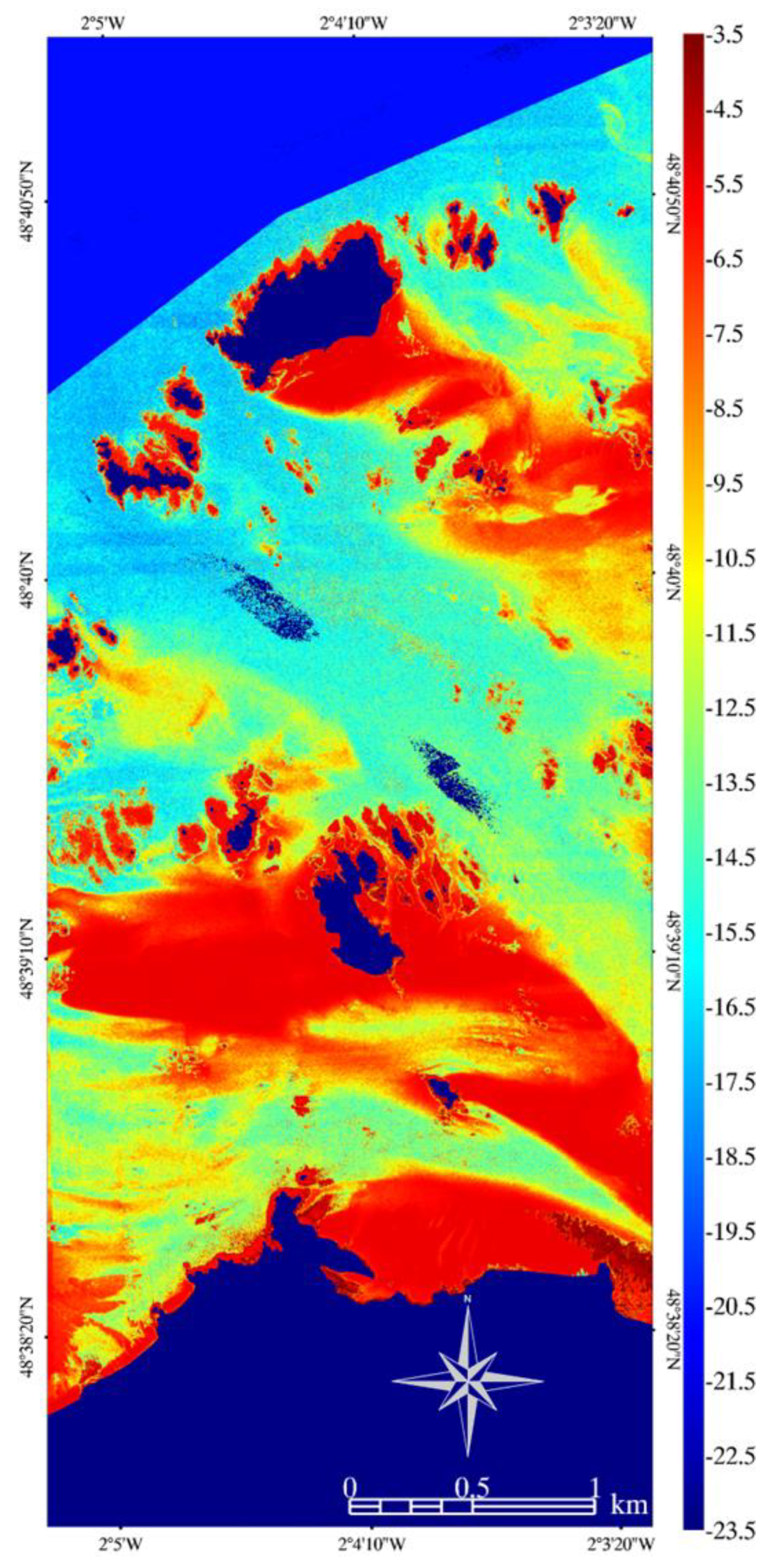
The best models were equally found with the 6 PNEO bands for TOA DN, TOA radiance, and TOA reflectance (R2test = 0.81, Figure 3), followed by BOA maritime and BOA tropospheric reflectance (R2test = 0.75 and 0.76, respectively). It is, therefore, recommended to use TOA radiometric levels, which corroborate bathymetric results stemming from the WorldView-2 sensor [5].

4. Conclusions

The capacity of the novel bands associated with the PNEO sensor, compared to Pléiades-1 (BGRIR), to derive bathymetry was estimated over the bay of Saint-Malo (Channel Sea, France) using lidar response and a shallow neural network. Irrespective of the radiometric level, the replacement of the blue by the deep blue increased reference results by 0.01, the addition of the deep blue to the reference gained 0.02, and the use of all six bands increased by 0.06, reaching R2test = 0.79. The best radiometric levels were equally TOA DN, TOA radiance, and TOA reflectance (R2test = 0.81).

Author Contributions

Conceptualization, A.C., D.J. and E.F.; methodology, A.C., D.J. and E.F.; software, A.C., D.J. and E.F.; validation, A.C., D.J. and E.F.; formal analysis, A.C., D.J. and E.F.; investigation, A.C., D.J. and E.F.; resources, A.C., D.J. and E.F.; data curation, A.C., D.J. and E.F.; writing—original draft preparation, A.C., D.J. and E.F.; writing—review and editing, A.C., D.J. and E.F.; visualization, A.C., D.J. and E.F.; supervision, A.C., D.J. and E.F.; project administration, A.C., D.J. and E.F.; funding acquisition, A.C., D.J. and E.F. All authors have read and agreed to the published version of the manuscript.

Funding

This research received no external funding.

Institutional Review Board Statement

Not applicable.

Informed Consent Statement

Not applicable.

Data Availability Statement

Data are unavailable due to privacy.

Acknowledgments

The authors are grateful to the French Office for Biodiversity for authorizing the UAV flights over natural and semi-natural habitats.

Conflicts of Interest

The authors declare no conflicts of interest. The funders had no role in the design of the study, in the collection, analysis, or interpretation of data, in the writing of the manuscript, or in the decision to publish the results.

References

  1. Mayer, L.; Jakobsson, M.; Allen, G.; Dorschel, B.; Falconer, R.; Ferrini, V.; Lamarche, G.; Snaith, H.; Weatherall, P. The Nippon Foundation—GEBCO Seabed 2030 Project: The Quest to See the World’s Oceans Completely Mapped by 2030. Geosciences 2018, 8, 63. [Google Scholar] [CrossRef]
  2. Guenther, G.C.; Brooks, M.W.; LaRocque, P.E. New capabilities of the “SHOALS” airborne lidar bathymeter. Remote Sens. Environ. 2000, 73, 247–255. [Google Scholar] [CrossRef]
  3. Collin, A.; Hench, J.L. Extracting shallow bathymetry from very high resolution satellite spectral bands and a machine learning algorithm. Int. Counc. Explor. Sea (ICES) 2015, CM, 24. [Google Scholar]
  4. Collin, A.; Palola, P.; James, D.; Pastol, Y.; Monpert, C.; Loyer, S.; Stoll, B.; Feunteun, E.; Wedding, L. SuperDove-modelled bathymetry using neural networks along a turbidity gradient; Bréhat, Saint-Barthélémy and Tetiaroa Islands. Int. Arch. Photogramm. Remote Sens. Spat. Inf. Sci. 2023, accepted. [Google Scholar] [CrossRef]
  5. Collin, A.; Hench, J.L. Towards deeper measurements of tropical reefscape structure using the WorldView-2 spaceborne sensor. Remote Sens. 2012, 4, 1425–1447. [Google Scholar] [CrossRef]
  6. Collin, A.; Etienne, S.; Feunteun, E. VHR coastal bathymetry using WorldView-3: Colour versus learner. Remote Sens. Lett. 2017, 8, 1072–1081. [Google Scholar] [CrossRef]
  7. Collin, A.; Pastol, Y.; Letard, M.; Le Goff, L.; Guillaudeau, J.; James, D.; Feunteun, E. Increasing the Nature-Based Coastal Protection Using Bathymetric Lidar, Terrain Classification, Network Modelling: Reefs of Saint-Malo’s Lagoon? In European Spatial Data for Coastal and Marine Remote Sensing; Springer International Publishing: Cham, Switzerland, 2022; pp. 235–241. [Google Scholar]
  8. Collin, A.; Planes, S. What is the value added of 4 bands within the submetric remote sensing of tropical coastscape? Quickbird-2 vs WorldView-2. In Proceedings of the IEEE International Geoscience and Remote Sensing Symposium, Vancouver, BC, Canada, 24–29 July 2011; pp. 2165–2168. [Google Scholar]
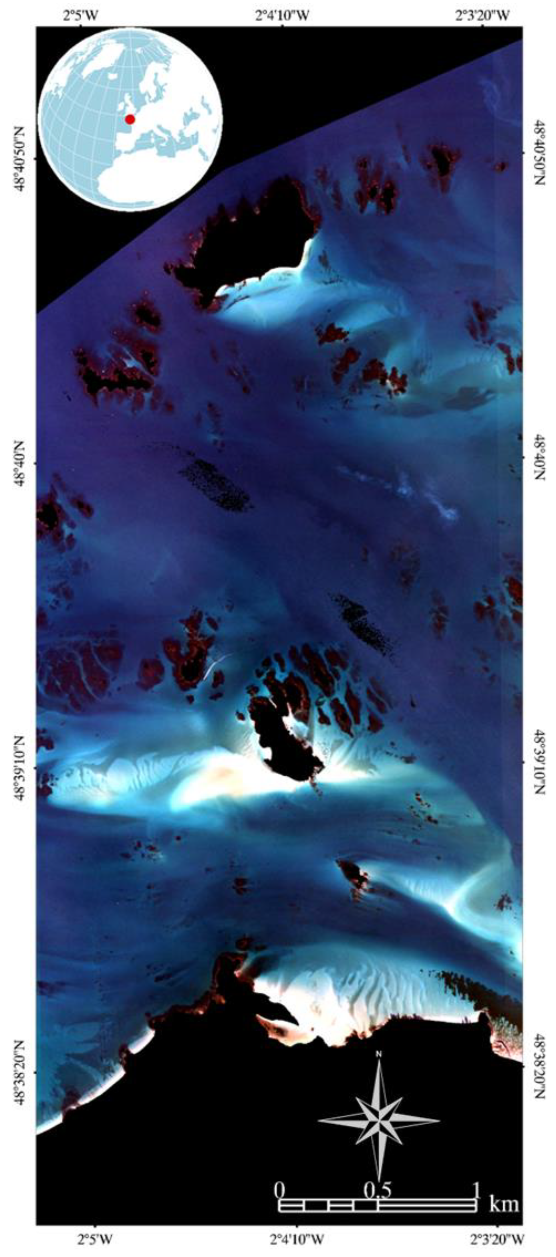
Figure 1. Blue–green–red composite PNEO imagery of the study site and its global location (RGF93 Lambert 93 IGN69; 2057 × 5067 pixels; 1.2 m pixel size).
Environsciproc 29 00068 g001
Figure 2. Lidar-derived bathymetry of the study site (RGF93 Lambert 93 IGN69; 2057 × 5067 pixels; 1.2 m pixel size).
Environsciproc 29 00068 g002
Figure 3. PNEO-derived bathymetry of the study site is based on a neural network developed with the six PNEO bands at the top-of-atmosphere radiance level (RGF93 Lambert 93 IGN69; 2057 × 5067 pixels; 1.2 m pixel size).
Environsciproc 29 00068 g003
Table 1. Spectral specifications of the Pléiades Neo sensor.
Band NamesLower WavelengthUpper Wavelength
Deep blue400450
Blue450520
Green530590
Red620690
Red edge700750
Near-infrared770880
Disclaimer/Publisher’s Note: The statements, opinions and data contained in all publications are solely those of the individual author(s) and contributor(s) and not of MDPI and/or the editor(s). MDPI and/or the editor(s) disclaim responsibility for any injury to people or property resulting from any ideas, methods, instructions or products referred to in the content.