1. Introduction
The provision of georesources represents an intervention in nature and the environment, where the intervention and its consequences are visible on the surface. Particularly in borehole mining and the underground storage of raw materials, the actual process is only partially visible and traceable. Mine surveying and geo- and environmental monitoring serve to technically monitor the provision process and to build up an understanding of the process, thereby supporting public participation. This public participation process goes beyond simple communication (“communication of results”) and represents multilateral participation of the various stakeholders. Particularly in the context of the current energy transition, the issue of sustainable energy supply, including hydrogen storage, and the problems of security of supply, it is necessary to use various participation formats.
1.1. The Cavern Field Epe
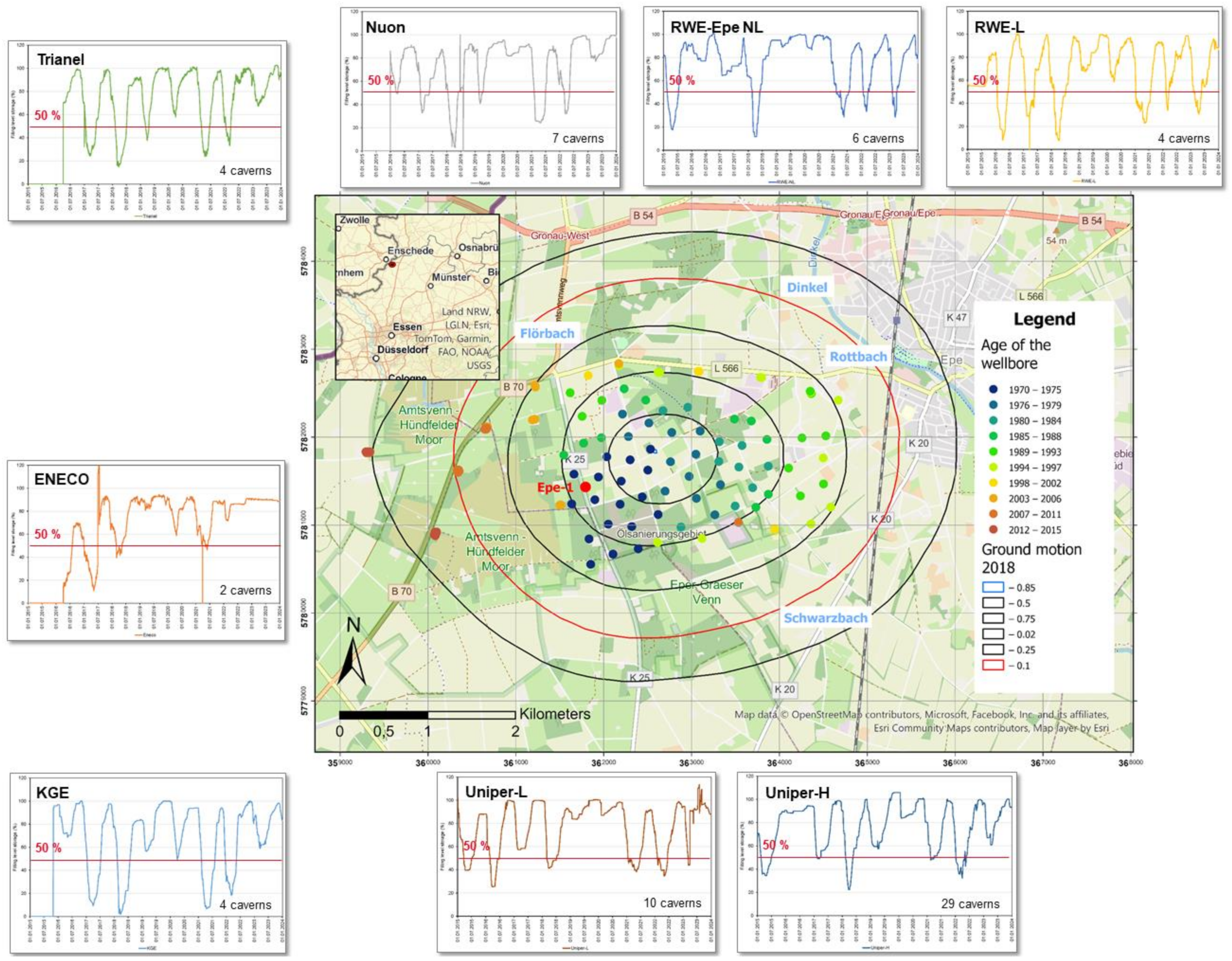
The Epe cavern field is located in the north-west of North Rhine-Westphalia in the German–Dutch border region of Gronau (D) and Enschede (NL). On 24 July 1964, the Epe-1 well was drilled on the road from Gronau to Graes (
Figure 1).
The aim was to explore the potential for natural gas, as the first promising gas discoveries had been made at the time, including in the Netherlands. However, instead of natural gas, several rock salt sequences of the Zechstein formation were found, which was not yet known at the time [
3,
4]. As a result, the salt sequences were developed and are now used for underground brine extraction and product storage in Zechstein sequences. The rock salt found consists of 98–99% sodium chloride (NaCl) and is therefore very pure. This is unique in the Permian Salt Basin in Northwestern Europe. In addition, the deposit is not only up to 400 m thick but is also relatively shallow and has no significant faults or folds [
4]. The solution mining process is still ongoing in the western part of the cavern field. The caverns in the eastern part are in the storage operation for natural gas, crude oil (five caverns) and helium (one cavern) (
Figure 1,
Table 1).
The primary extraction rights and responsibility under mining law for brine operations lie with Salzgewinnungsgesellschaft Westfalen mbH & Co. KG (SGW). SGW is also the central company that carries out mine surveying at the site. Responsibility under mining law for underground storage lies with the various storage operators (
Table 1).
To date, more than 100 wells have been drilled and 114 caverns have been solution-mined. In total, the cavern field extends east of the settlement of Gronau-Epe over an area of around 5 km by 5 km and has an extension area towards the Dutch border. In the so-called old field, the eastern part of the cavern field, the drilling sites and the underground caverns are laid out in a kind of regular grid with a lateral spacing of approx. 300 m. The western, new part of the cavern field comprises collective drilling sites with several deviated boreholes.
Overall, the subsurface use has triggered the development of a subsidence trough, which is monitored centrally by the SGW mine surveying department (
Figure 1) [
6,
7]. To date, almost 90 cm of ground movement has occurred during the subsidence maximum. These mining-induced ground movements in the cavern field proceed very slowly and evenly, whereby a seasonal overprint with the type of injection and withdrawal (including winter with low temperatures) is recognizable (
Figure 1, operational schemes of the different operators). It can also be seen that cavern operators with few caverns have a higher temporal fluctuation range in the working gas levels.
On the surface, the eastern part of the area is characterized by agricultural use and a scattered settlement, the Kottiger Hook. Between this scattered settlement and the district of Gronau-Epe flows the river Dinkel, which is the supra-regional receiving water for the smaller watercourses (
Figure 1). From 27 August 2010 to 29 August 2010, there was a high water event on the Dinkel, which flooded parts of the urban area of Epe and led to backwater in the local receiving waters [
7,
8]. The western part of the area is characterized by two bogs and nature conservation areas, the “Amtsvenn” and the “Hündfelder Moor”. Both bogs no longer have their original, natural extent, as large-scale peat extraction has taken place here in the past. The two bogs are currently being re-naturalized and thus re-wetted.
On 12 April 2014, a serious operational accident occurred in the cavern field, which resulted in damage to nature and the environment [
9]. When a casing failed in a cavern in the old field of the cavern field, the storage medium crude oil leaked out. This accident triggered a broad public discussion on the monitoring of cavern storage facilities. Since then, the focus has been on ground movement at the surface [
10,
11,
12]. The work of the local citizens’ initiative cavern field Epe should also be mentioned in this context [
13].
In order to achieve a more in-depth understanding of the ground movements in the cavern field, the administration of the city of Gronau was requested by a council resolution of 7 October 2020 to carry out an independent subsidence measurement in the area of the cavern field [
14]. This decision was accompanied by several reports on WDR television, WDR radio and local newspapers [
11,
12,
15].
1.2. Objectives of the Research Cooperation
This public discussion gave rise to the “Epe Research Cooperation” with the cooperation partners city of Gronau, citizen’ initiative cavern field Epe, EFTAS, Münster and the Research Center for Post-Mining of the Technische Hochschule Georg Agricola, Bochum. This research cooperation is the first in Germany to involve direct collaboration between science and the public. So far, only in some examples, citizens’ initiatives have directly interacted with the operator but not via scientists [
16].
The committee of the city of Gronau for Mobility, Environment and Climate Protection passed a resolution on this, which was unanimously approved by the representatives [
15,
17]. The cooperation serves to address several questions and tasks:
Deepening a technical understanding of borehole mining and underground storage in the context of ground movement and determining the area of impact;
Use of radar satellite remote sensing methods (EU Copernicus program) to increase the spatial monitoring frequency as well as retrospective time series analysis using the mine survey maps, GNSS measurements from Geobasis NRW, open geodata (e.g., Geobasis NRW, Geoportal NRW) and on-site analyses;
Development of an integrated understanding of ground movements at the edge of the subsidence trough;
Developing an understanding of the hydrological and hydrogeological development of the cavern field, particularly with regard to flood protection;
Pooling the competencies and bringing together the participants and citizens for on-site analysis and scientific transfer;
Scientific–technical and independent analysis.
To ensure transparent communication and participation, a steering committee was set up at the same time as the research cooperation, consisting of representatives from politics, the local and district administration and the citizens’ initiative. SGW and the various operators of the underground gas storage facilities in the cavern field refrained from offering direct participation in order to enable the research cooperation to deal with the issues in a comprehensive and unbiased manner. SGW provided mine survey maps, in particular on the vertical ground movement and other technical geodata.
2. The Process of Public Participation
Social trust, especially in science, is a valuable asset that should be built up and continuously maintained in scientific and technical projects. This applies in particular to projects in the mining life cycle, where there is an impact on nature and the environment and at the same time a change in social perception, through the rapid availability of information (e.g., internet, social media). This made it necessary to actively develop transfer measures in order to generate understanding for scientific working methods. This is important to obtain results on the one hand and to maintain the social and subjective trust of the citizens in the study area on the other. Therefore, the overarching task is to address citizens’ uncertainties, which are often fed by the ambivalences inherent in science [
18]. This is particularly true when it comes to constant further developments and complex technical interdependencies that are not immediately tangible. The uncertainties that exist here, which have their origins in fundamental ideological questions or misunderstandings that arise due to ambivalences, cannot be neutralized by fact-based trust but require emotionally anchored trust [
18,
19,
20,
21].
The challenges lay primarily in communicating scientific and technical content to the target group of citizens in the study area, who had different requirements and experiences and also already had an established opinion. The secondary objective was to stimulate a process of understanding that would enable a fact-based assessment of past, present and future developments in cavern use. It is therefore important, as Nina Janich [
22] convincingly argues, that “science communication must also actively address the social construction of its knowledge, the rhetorical dimensions of scientific language and communication and also the question of how to deal transparently with scientific ignorance and uncertainties”.
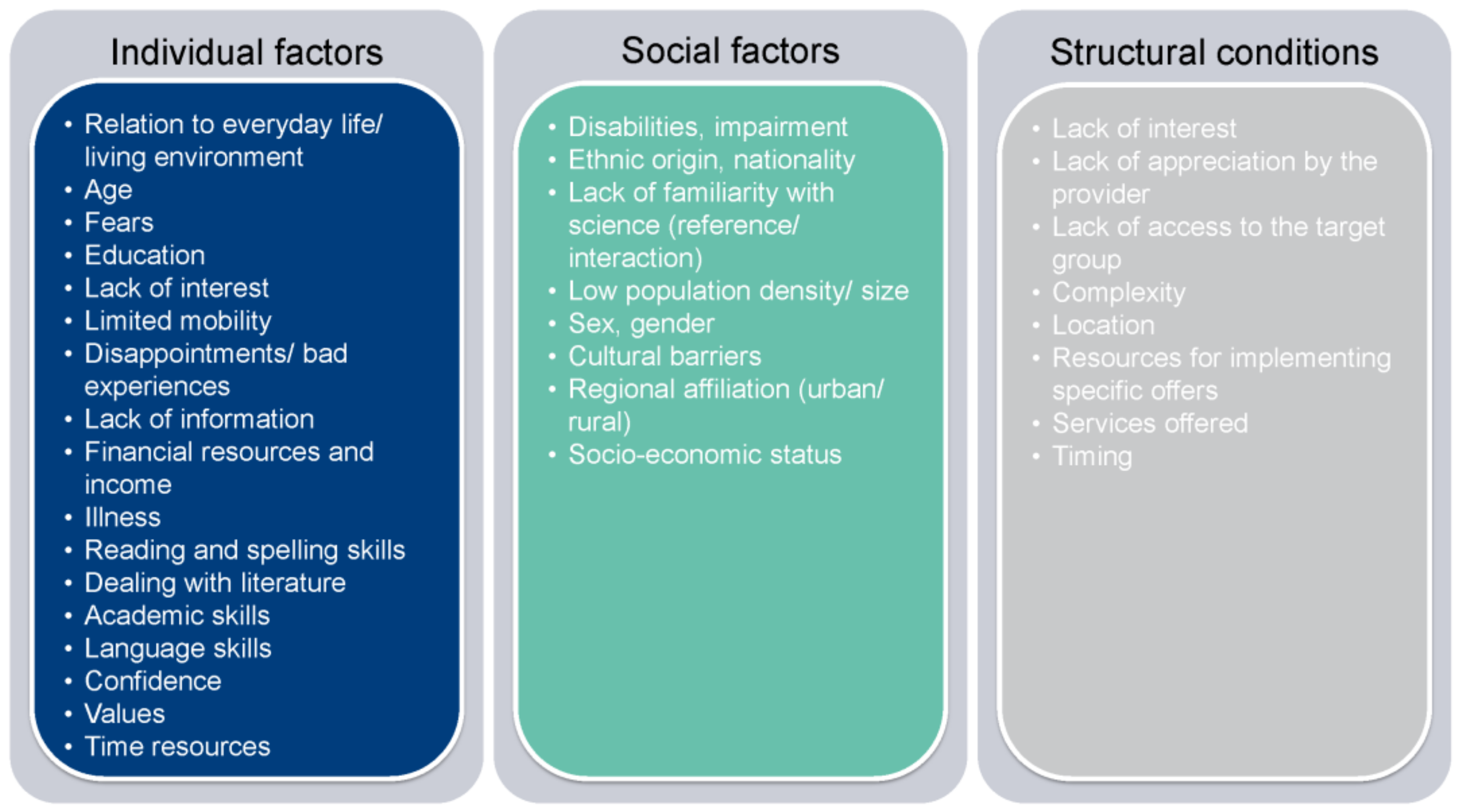
In addition, consideration must be given to how the groups affected by change are informed and how it is ensured that the scientific and technical content is understood and communicated in a sensitive way. Three factors need to be considered here (
Figure 2) [
23]:
Individual factors;
Social factors;
Structural conditions.
Figure 2.
Factors influencing the accessibility of target groups (after [
23]).
Figure 2.
Factors influencing the accessibility of target groups (after [
23]).
These three factors must be taken into account in the resilience management of projects in the mining life cycle and addressed with appropriate measures. The analysis by Schrögel et al. [
23] shows that trust plays an important role in both the individual and the social factors. A comparison of the factors also shows that different tools and methods are required for the transfer of knowledge and science as well as for communication.
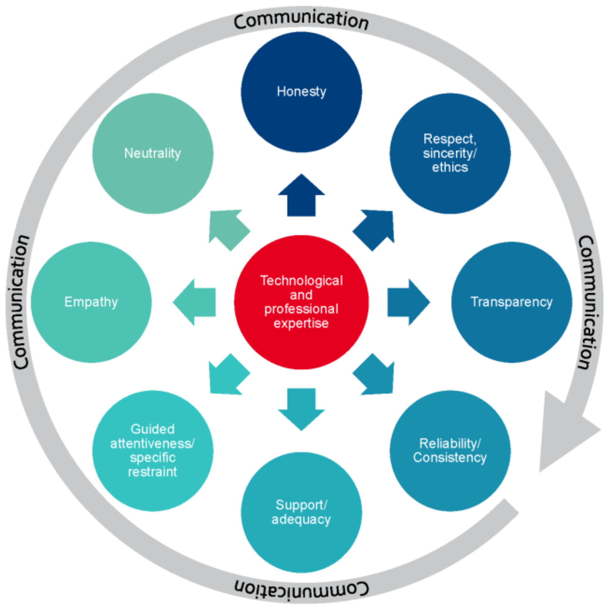
It is therefore important to establish a common basis for resilience here, i.e., trust, and to support this in the broadest sense through communication and thus build perspectives (
Figure 3). A detailed analysis of the concept of trust shows that it consists of nine interlinked aspects [
24].
The first concrete steps in science communication in this project included the development of a common scientific basis, a so-called knowledge corpus (
Figure 4). To this end, the various aspects of the mining life cycle, the working methods of geo- and environmental monitoring and the areas of application of modern satellite remote sensing were explained.
In addition, a website (
www.monitoring-epe.de, accessed on 8 April 2024) has been set up to openly communicate dates, content and results of the research cooperation to the interested public. This website is the essential link in the participation process and offers the opportunity to get in touch with the research cooperation team. More importantly, the website supports the building of local, public resilience. For example, results of the field trips and corresponding photo documentation were made available here. This creates transparency for mining measures and builds trust. As an important tool for participation, the website included a WebGIS with publicly available and official geodata. This means that interested members of the public can follow the results independently and gain their own insight into the situation on site.
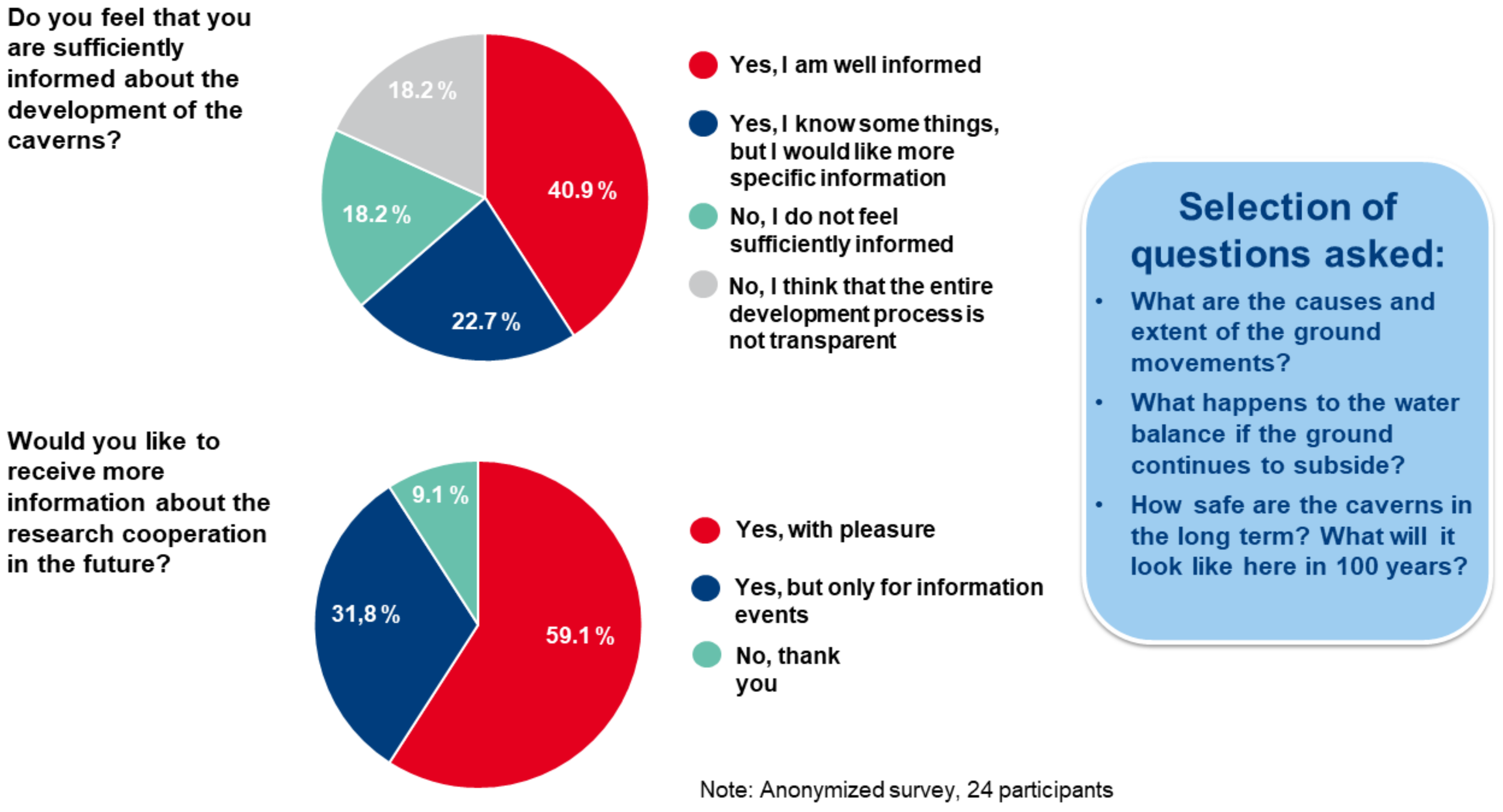
A survey for the public was also published on the website. This survey served to identify interests and needs, fears and concerns, as well as ideas for further research questions, and to incorporate these directly into the research cooperation. Associations, companies and authorities were also approached and informed about the activities. Geodatasets were made available for the work through discussions with the companies active in the cavern field. The Arnsberg District Government—Department 6, Mining and Energy in North Rhine-Westphalia was directly involved due to the mining law aspects of the research cooperation. For the surveying aspects, direct contacts have been established with the authorities at district and state level, namely the Cologne District Government—GeoBasis NRW and the Borken District—FB62 Geoinformation and Real Estate Cadastre.
In order to create an understanding of the often scientifically and technically complex processes among the interested public, the research cooperation regularly held information events, which were accompanied by experts from science communication (
Figure 4). The contents of the five public information events, which were held in the Gronau town hall and in the research area (lasting approx. 2 h), focused on:
Introduction to cavern operation: Borehole mining in the Eper Amtsvenn and its effects with reference to a 3D underground model;
Mining law and mining damage;
Bicycle excursion cavern operation;
The future of cavern operations in the Eper Amtsvenn;
Geo- and environmental monitoring of mining sites.
The bicycle excursion through the cavern operation enabled a very special form of participation and transparency: citizens had the opportunity to ask their questions, which could be explained by the experts of the research cooperation and external experts directly “on site”. Furthermore, all stakeholders involved were networked in a relaxed, trust-promoting atmosphere.
In addition, individual aspects such as hydrogeology were dealt with in several courses as part of the student training program, thus enabling further scientifically neutral processing [
25]. The results were taken up directly by the research cooperation.
3. Methodology
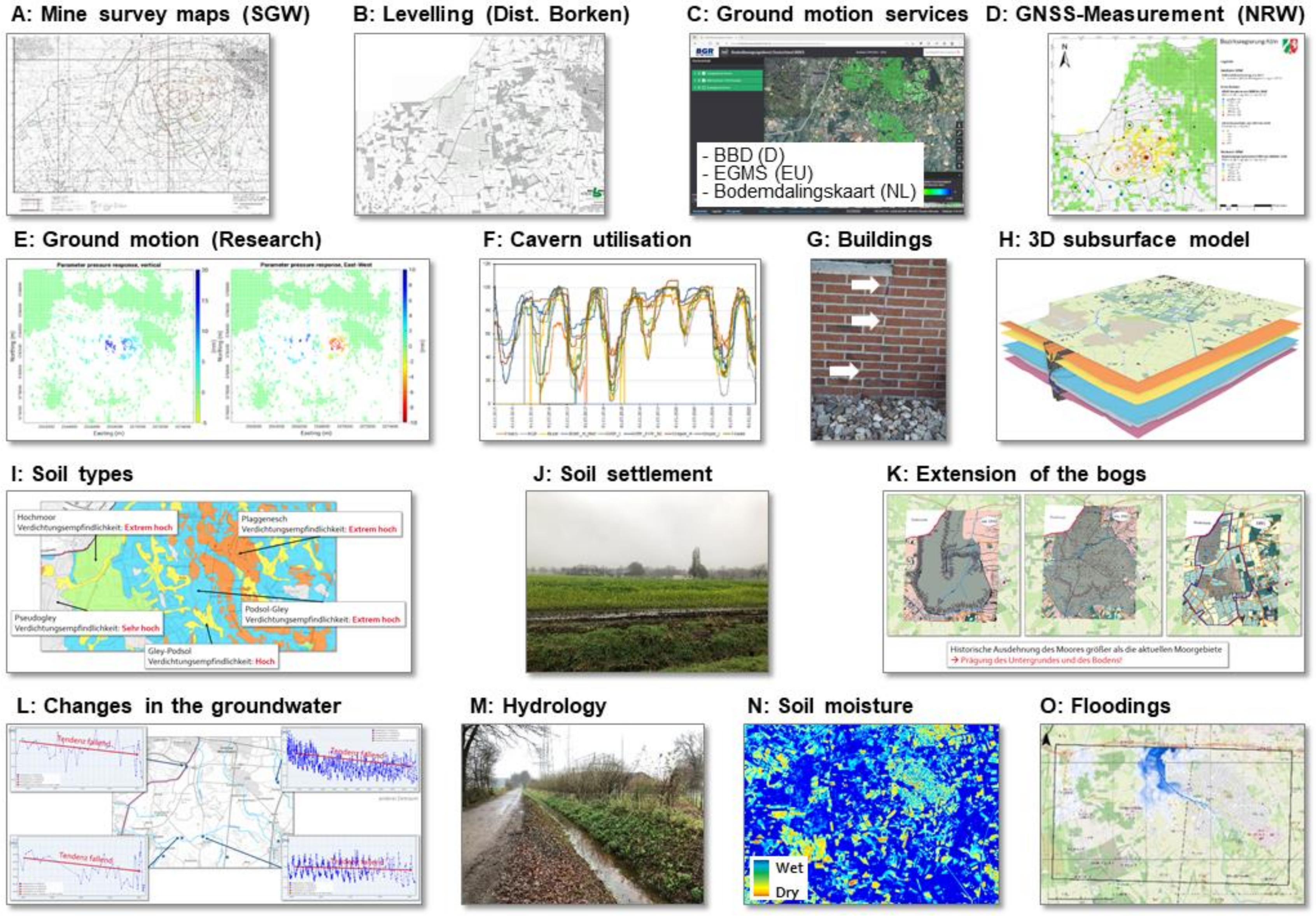
The evaluation of the available public geodata from GeoBasis NRW and from the Geoportal NRW as well as an extensive internet and literature search showed that there is a superposition of different effects in the area of the Epe cavern field that can trigger ground movement. The consequences of climate change, with changes in precipitation, also play an important role here. The triggers for ground movement and possible damage to buildings are as follows:
Underground cavern operation (
Figure 5A–H);
The remaining Amtsvenn and Hündfelder Moor with partially peat-covered and agriculturally used areas (
Figure 5I–K);
Strong fluctuations in the groundwater level and soil moisture (
Figure 5L–N);
Decomposition of biomass due to air supply to the soil (
Figure 5I,K,L);
Former floodplain areas along receiving waters with water level fluctuations (
Figure 5O);
Locally very differently formed, settlement-sensitive soils with a strong tendency to form waterlogging (
Figure 5J);
Old scattered settlements with an age of construction of >60 years in some cases and a modern valorization of the building shells and extensions (
Figure 1 and
Figure 5G).
3.1. The Local Analysis
Due to this interplay of the different components of ground movement, the available geodata were evaluated as a time series, and almost monthly inspections were carried out. All data were converted into a geographic information system (
Figure 5). The ESRI Software ArcGIS Pro was used for this purpose.
As a first step, all available geodetic datasets were compiled and evaluated on the basis of the mine survey maps and ground movement maps. (
Figure 5A–E). The different datasets show different results in the ground movement due to different time periods and monitoring periods. In addition to evaluating the levels of the underground storage facility, a mining damage survey was carried out to understand the effects on the surface (
Figure 5F,G). The mining damage survey showed no direct link of the damage types to the mine operation. For the selected objects, the documentation and assessment of the ground movements and the interaction with the building infrastructure was evaluated. The three objects were selected by the citizens‘ initiative. One building complex in the subsidence maximum; one building in the subsidence edge area, at the 10 cm subsidence line; and one building in the subsidence edge area, but in the floodplain area of the large Dinkel receiving watercourse, were surveyed.
In addition, a simple subsurface model was constructed in order to be able to evaluate the influence of the caverns, the deeper geological layers and the tectonics on the surface (
Figure 5H). In the further spatiotemporal evaluation, the results on the surface layers were analyzed in particular with regard to the spread of the former bogs, soil types and properties, hydro-(geo)logy and soil moisture (
Figure 5I–N). The available geodata on flood events were also evaluated (
Figure 5O). This fusion of the geodata gave a detailed insight into the structure of the surface layers and the link of the near-surface ground movement with water- and humus-rich soils.
During the various inspections, 14 additional objects, which are distributed across the entire cavern field, were also selected by the citizens’ initiative in order to carry out a detailed evaluation of the results of the geo- and environmental monitoring with the radar satellite remote sensing data.
3.2. Radar Satellite Remote Sensing
Radar satellite remote sensing offers the possibility of deriving ground movements from the comparison of a time series of datasets. This involves radar interferometry (InSAR = Interferometric Synthetic Aperture Radar). So-called persistent scatterer interferometry (PSI) is usually used, but this is dependent on the presence of stable backscatterers (PS) for the radar signal, such as buildings [
36,
37,
38]. When using radar interferometry for a rural area such as the Epe cavern field, however, a method must be selected that enables the ground movements to be displayed as comprehensively as possible despite a very low building density. A suitable method for this purpose is Small-Baseline Subset (SBAS) [
39,
40]. The radar interferometric analyses carried out are therefore primarily based on SBAS. In addition, persistent scatterer interferometry (PSI) was applied using fixed backscatterers. However, the results are not redundant and not directly comparable due to the different methods. Rather, they represent complementary information. These differences must be taken into account when analyzing and interpreting the results and can provide added value for differentiating the causes of ground movements. For example, SBAS can also depict the movements of the topsoil induced by changes in soil moisture [
41,
42], while the movements of the buildings determined by PSI are more likely to depict the ground movements caused by cavern operation if the foundations of the buildings are sufficiently deep. In this study, two methods were applied. For the first period from the end of year 2015 until the end of 2021, a combination of the PSI and SBAS methods were applied, and the datasets combined and then analyzed. The software ENVI SARscape was used. For the period from 2022 onwards, a so-called enhanced SBAS (E-SBAS) for ground movement analysis was implemented in ENVI SARscape [
36,
40]. In principle, the PS points will be further extracted, refined and processed from the distributed scatterer (DS) points. This means that PSI and SBAS are combined into a single processing step. The coverage of movement data is extended along with an improvement of movement precision.
At the beginning of the research cooperation, the Ground Motion Service Germany (BBD) (
https://bodenbewegungsdienst.bgr.de/, accessed on 8 April 2024), which is provided by the Federal Institute for Geosciences and Natural Resources (BGR), only showed the ground movement as movement in the direction of the sensor (line-of-sight) and not as vertical movement. This led to comprehension problems for the local parties involved. In addition, the results were only displayed on the BBD web portal as persistent scatter interferometry (PSI). The European Ground Motion Service (EGMS) (
https://egms.land.copernicus.eu/, accessed on 8 April 2024) was activated in the course of the research cooperation and shows the vertical movement of persistent scatterer elements. The results of the Dutch equivalent, the Bodemdalingskaart (
https://bodemdalingskaart.portal.skygeo.com/, accessed on 8 April 2024), also show the ground movements vertically. With this service, however, it must be taken into account that the Epe cavern field lies at the edge of the evaluation, i.e., outside the core observation. This means that boundary effects can influence the interpretation.
It was therefore necessary to carry out a dedicated radar interferometric evaluation for the Epe cavern field. The datasets with the following properties were used in the processing:
650 Sentinel-1 scenes (2015–2021), 110 Sentinel-1 scenes (2022–2023);
Ground resolution 30 m × 30 m;
Time span from 20 November 2015 to 28 December 2021 and 11 January 2022 to 21 October 2023;
Ascending + descending orbit;
Polarization VV.
The ground movements calculated using the SBAS method were implemented as a map-based time series display and also explicitly considered in detail for the 17 objects in the cavern field.
4. The Result of the Fusion of the Geodatasets
The complexity of the research cooperation lies in the consolidation and evaluation of multisensory and multi-temporal datasets and the validation with on-site observations. It must also be taken into account that the observed effects of ground movements in relation to other mining areas (including the Ruhr region) are manageable and can overlap with each other. During the entire period of the research cooperation, the caverns in the eastern part of the cavern field were involved in the gas storage operation (
Figure 1, east of the road in a N-S direction at the Epe-1 exploration well). The oil caverns in operation are located in the far SW corner of the cavern field. The caverns in the brine operation are the caverns along the B70 federal highway in the westernmost part of the cavern field (
Figure 1).
The process of public participation in the research cooperation was very successful. The initial survey carried out via the research cooperation website showed the high demand for information and that there were very far-reaching technical questions (
Figure 6). Furthermore, the work of the research cooperation was accompanied by several articles in newspapers and magazines [
15,
43,
44,
45,
46,
47,
48]. The work was also presented at a number of conferences, and publications were submitted. Overall, public awareness of the issue of public participation in geo- and environmental monitoring was increased [
49,
50,
51,
52].
The mining damage inspection of selected objects showed a differentiated picture. In the documented properties, there were no typical tilted positions and no formations of steps or cracks in the large, paved courtyards. The cracks in the facades/exterior shells of the buildings were also mostly not correlated with cracks in the interior walls, cellars and floor slabs. The documented damage is presumably an interplay of natural, local ground movement with anthropogenic factors, in some cases without mining influence.
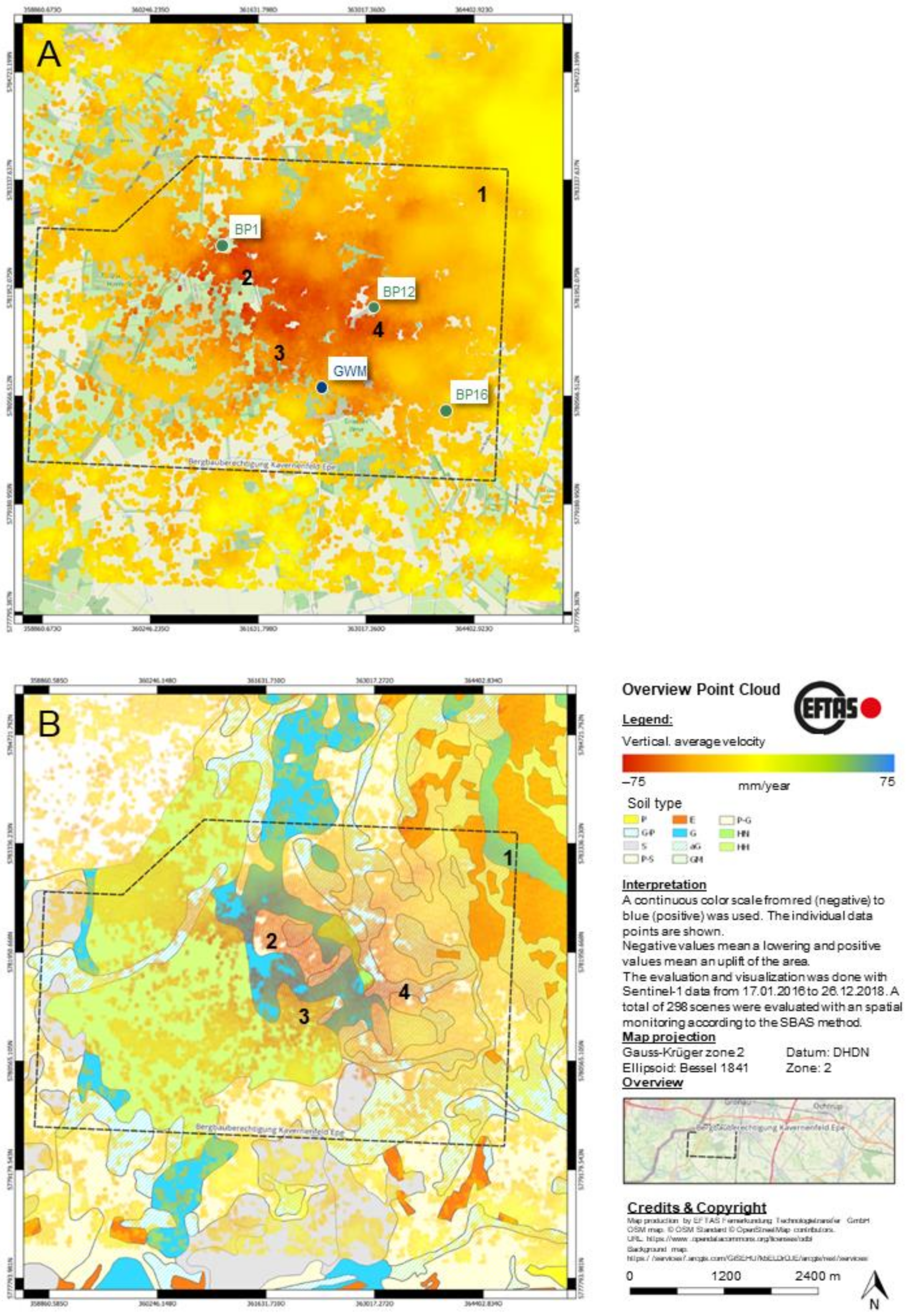
The inspections of the cavern field revealed very diverse results. The geological and pedological mapping confirmed that the distribution of the bog sequence and the humus layers extend beyond the boundaries of the current nature reserve (
Figure 7B). This could be seen very clearly in the dark, humus-rich soils that are used for agriculture. The problem of waterlogging after prolonged rain events was also very clearly evident here (
Figure 5J). At the same time, however, no influences from the subsurface, such as geological discontinuities, could be mapped.
The hydro-(geo-)logical mapping showed the receiving waters draining to the north and the effluent conditions of the aquifer into the receiving waters. The researchers’ groundwater table measurements showed groundwater table distances between 0.5 m and 1 m. The three larger receiving waters also showed a lack of vegetation on the watercourse bed during periods of high precipitation, which indicates seasonally constant discharge conditions, as there is no weed growth. Weed growth only occurs at times of low flow/standstill of flow [
38,
39]. However, these weeds are removed annually. The groundwater table measurements also showed that the observed waterlogging is decoupled from the aquifer.
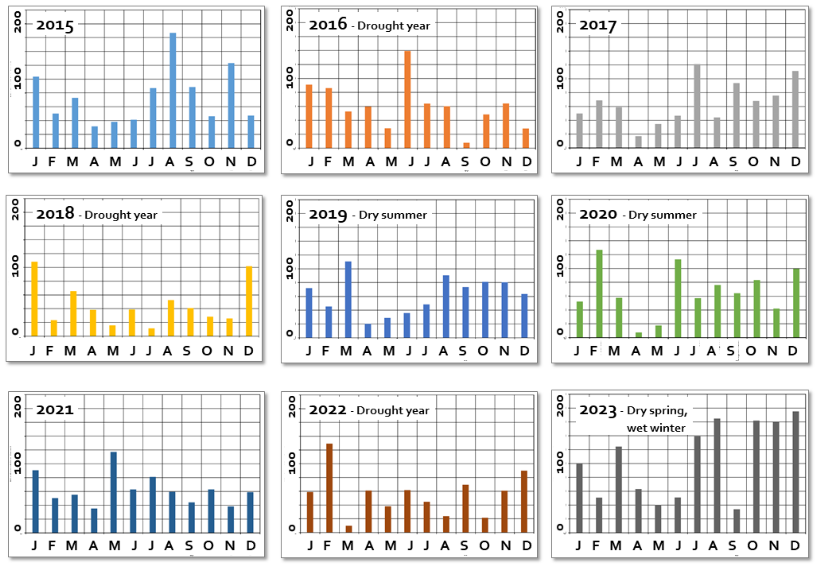
The time series analysis of the public hydro-(geo)logical and weather data provided an important insight into the changes in the groundwater level and the possible implications for the surface. In addition to seasonal fluctuations in the groundwater level, the influence of climate change was also very clearly evident in the change in precipitation (
Figure 8).
Especially in the first dry summer in 2018, there was a drop in groundwater levels (
Figure 9). The evaluation of the hydrology, especially flood maps [
29], and simple modeling of other potential dispersion scenarios based on the future subsidence trough showed that the morphology of the terrain partially hinders dispersion. The scenario of large areas of the subsidence trough being flooded during a high water event does not appear to be plausible. However, further investigations and modeling are necessary here.
The holistic evaluation of the mapped geological, pedological and hydro-(geo-)logical conditions thus showed that the behavior of the soil types on the surface is very strongly dependent on the water content. The fluctuations in the groundwater table lead to a loss of buoyancy and to irreversible decomposition in the soil. This induces the development of secondary ground movement, which is decoupled from the primary, mining-induced ground movement.
Soil dehydration can also be detected using satellite remote sensing data. The use of the Normalized Difference Moisture Index (NDMI) provides a way of visualizing water stress in plants (
Figure 5N). For the area of the research cooperation, it can be seen that there is basically a sufficient water supply, but in dry summers (2018, 2019), especially in the vicinity of remaining peatlands, drought stress occurs [
27,
29]. This may indicate that the (ground) water supply is not fully or sufficiently available for vegetation.
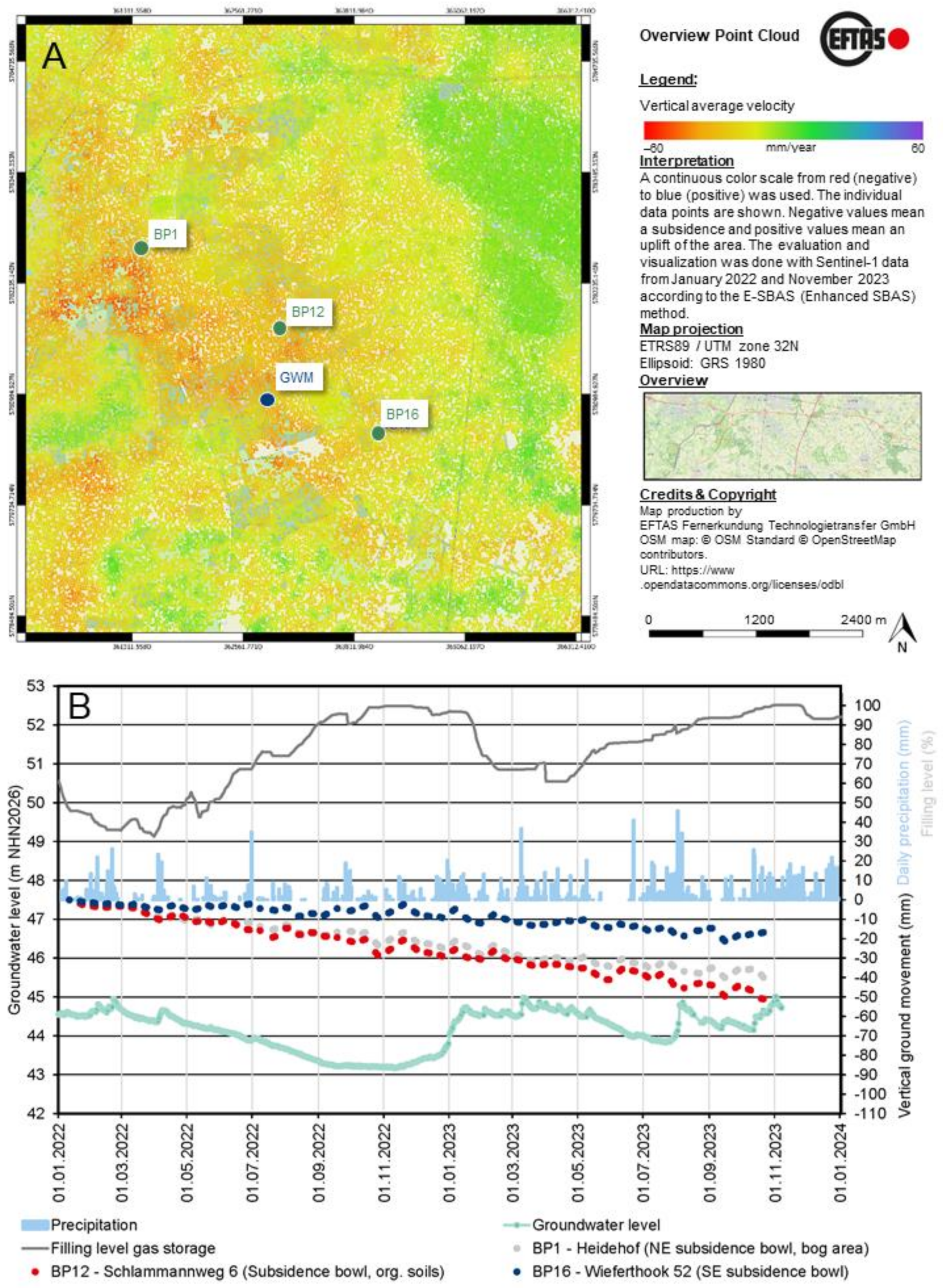
The evaluation of the radar satellite remote sensing data for the cavern field provided for the first time a spatial representation of the ground movements from 17 January 2016 to 28 December 2021 (
Figure 7) and 11 January 2022 to 21 October 2023 (
Figure 10). The first period of evaluation represents a significant extension to the public ground movement data and official mine survey data [
53] already available (
Figure 7A). Although the results of this evaluation clearly show the influence of mining, the overall ground movement is not uniform. This is particularly noticeable in the peripheral areas towards the bogs and towards the river Dinkel (
Figure 7B, 1–4). The continuation of the radar satellite remote sensing in the second period or 2022 and 2023 revealed a different picture, as the cavern storage mode, triggered by a geopolitical influence, and the weather conditions on site have changed significantly (
Figure 10A).
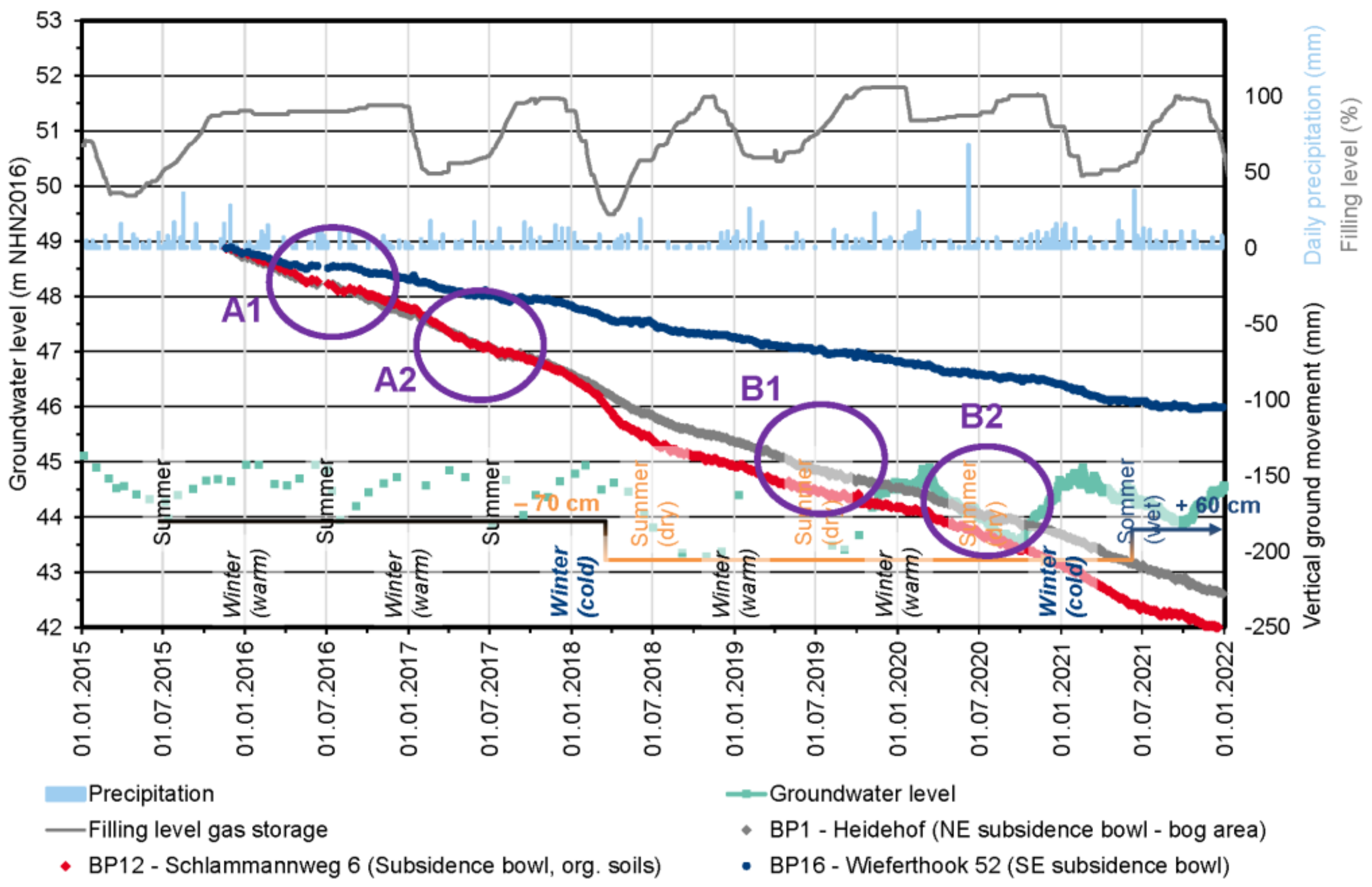
Figure 9.
Diagram of the vertical ground movement at selected points in the cavern field in comparison to the filling level of the caverns, groundwater level and the precipitation (position of the points in
Figure 7) for the period of the end of 2015 until the end of 2021 (gaps = no data) (after [
28,
53]).
Figure 10.
Representation of the vertical ground movement at selected points in the cavern field in comparison to the filling level of the caverns, groundwater level and precipitation (gaps = no data) (after [
28,
53]).
Figure 10.
Representation of the vertical ground movement at selected points in the cavern field in comparison to the filling level of the caverns, groundwater level and precipitation (gaps = no data) (after [
28,
53]).
5. Discussion of the Results
The ground movements show the staircase-like seasonal ground movements typical of a cavern storage facility (
Figure 9, A1, A2). These are the slightly staggered subsidence in the period of natural gas withdrawal in the fall/winter and the slowdown in subsidence in the period of natural gas injection in the spring/summer. In the periods of summer 2017 and 2018, the staircase structure is not so clear, and the ground movement is more continuous (
Figure 9, B1, B2). The correlation with the soil maps and precipitation data shows a direct dependency here. For example, uniform ground movement can be found in areas with settlement-sensitive soils (organic soils) (
Figure 9, B1, BP12). The simultaneous correlation of the documented ground movement with precipitation data shows that the periods in question are low-precipitation phases, which have therefore led to a lowering of the groundwater table. The period of the summers of 2018, 2019 and 2020 is particularly noteworthy here, as the reservoirs have high filling levels and should therefore have led to a slowdown in ground movement.
The combination of the radar remote sensing for 2022 and 2023 and again the integration of data on precipitation and the fluctuating ground water level gave some different insights.
For example, 2022 was generally a very dry year, 2023 was characterized by a dry summer and the end of 2023 was very wet (
Figure 8). The long-term average annual precipitation for the location is around 750 mm to 800 mm [
54]. In the dry years of 2018 and 2022, the annual precipitation fell to around 550 mm to 630 mm. In 2023, the first months were comparable to previous years, with significantly lower precipitation in the spring and summer months (April to June, September). The months of July and August 2023 were very wet, with precipitation of around 140 mm/month. In the last months of the year (October, November, December), a total of just under 500 mm of precipitation fell (
Figure 8). This means that more than half of the annual precipitation of a normal year fell in one-quarter of the year.
The very different precipitation in 2022 and 2023 therefore has an influence on the ground movements at the Epe cavern site. The new spatial evaluation of the ground movement (
Figure 10A) now supports the statement on precipitation- and soil-type dependent ground movement compared to earlier evaluation (
Figure 7 and
Figure 9). For example, in the very dry year 2022, with very deep groundwater levels at 1.5 m to 2 m below normal levels, it can be seen that precipitation leads to ground uplift of a few centimeters (
Figure 10B). Nevertheless, the ground subsidence is very clear in 2022, as storage utilization had fallen to below 40% filling level in winter, which in combination with the subsidence maximum (
Figure 10B, BP12) led to a cumulative ground movement of 3 cm/year. The analysis of the soil types (
Figure 7B) shows that although point BP1 is located at the northwestern edge of the subsidence trough, it has almost the same cumulative ground movement as point BP12 in the subsidence maximum. The peat soils thus react directly to the water stress with a strong shrinkage.
For the wet year 2023, it can be seen that the ground movements are much more limited overall, but the periods of heavy precipitation led to ground uplift and slower subsidence. These effects are also visible in the direct comparison of BP12 and BP1 (
Figure 10B).
The spatial evaluation of the ground movements for the working area shows this spatial effect of the different vertical ground movement (
Figure 10A). The areas with soils with a high organic content and/or residual bogs show higher ground movement velocities (western cavern field) than the central areas with more sandy soils. The areas with residential areas, i.e., more settled objects, represent areas that show no/only slight ground movement.
This combination of geodata also demonstrates that it is not possible to predict the ground movements and thus build a forecasting model here, as a large number of non-modellable factors have an influence. For example, the operational modes of the caverns depend on the daily use (storage medium, filling level per cavern, rate of withdrawal, rate of injection, downtimes), and changes in settlement-sensitive soils/subsoil, groundwater and precipitation also play a role at the same time.
6. Conclusions
The production of brine and the underground storage of natural gas, helium and crude oil products represents an intervention in nature and the environment and therefore has a direct impact on the surface. Borehole mining is a special case here, as the processes take place underground and are therefore not visible. Only the surface effects, such as ground movements, have a visible impact that can trigger direct changes to buildings and infrastructure or even water bodies.
The changes in public perception and climate change, but also the growing need to ensure security of supply for Germany, make expanded geo- and environmental monitoring and intensive participation formats necessary in addition to traditional monitoring by mine surveyors. In this public exchange, it is necessary to consider the driving factors of the public, from individual factors to social factors and structural conditions, in order to achieve sustainability in communication and participation. The Epe research cooperation makes it possible to bring transparency to these complex geoscientific and technical processes in order to strengthen mining and enhance the public understanding of the ongoing processes. Developing partnerships with the public and bringing them to life is a serious task for scientists and science communication.
The evaluation of geodata available for the Epe cavern field shows that the geoscientific and technical situation here is complex. Part of the cavern field is covered by bogs and soils with a high organic content. The soils are very sensitive to ground movement. At the same time, the groundwater table is very shallow, and the strong fluctuations in the groundwater level lead to loss of buoyancy and decomposition in the soil, which in turn triggers ground movements.
The use of spaceborne radar satellite remote sensing is an important addition to the ground movement survey. This is because the application of this method provides ground movements with a high spatial and temporal resolution and makes it possible to clearly separate the influencing variables of ground movement for the Epe cavern field.
The results of the time series analysis of the radar interferometry analysis show a very heterogeneous map of ground movements. This is possible because very high-resolution datasets with 770 scenes in 8 years are available. The main factor influencing subsidence is the underground production of brine and the underground storage of crude oil, natural gas and helium. The average annual ground subsidence at the subsidence maximum is 2 cm/year. In dry years with little precipitation, however, it can be seen that there is a strong simultaneous influence from the drying out of soils and the falling of groundwater levels, which leads to an increase in subsidence. Thus, the annual subsidence increases to 3 cm/year, as was the case in 2022. In wet years, as in 2023, there is a partial swelling of the topsoil and thus, also in connection with a lower utilization of the reservoirs, not only a slowing down of the subsidence but also local uplift.
The local surveys carried out over the course of the year by the research cooperation have shown seasonal changes and also revealed the interaction with the influence of climate change (changed precipitation) and the prevailing hydro-(geo)logical conditions. These fundamental findings are important in order to evaluate the results from the radar satellite remote sensing in the future and to use them to expand the mining surveys.
The main results of the research cooperation can be summarized as follows:
The underground extraction of salt and the underground storage of gas generate ground movements at the surface.
There is a superposition of mining-induced ground movements with natural ground movements (e.g., swelling and shrinking of organic soils, fluctuations in the groundwater table) and with the consequences of climate change in the form of changes in precipitation.
These effects can be differentiated with the use of radar interferometry. The radar interferometry enables high-resolution monitoring in terms of time and space and represents a significant addition to the annual mine survey maps.
The long-term monitoring thus shows:
- a.
Significantly increased ground subsidence during dry years with simultaneous heavy utilization of the caverns (low filling level);
- b.
Significantly reduced ground subsidence and, in some cases, ground uplift in wet years with simultaneous low utilization of the caverns (high filling level).
The public participation process with a comprehensive introduction to the technology of underground storage turns those affected into participants.
The Epe research cooperation with its partners represents a modern and innovative format for building trust in the German mining industry. Only through direct, open and scientifically neutral cooperation has it been possible to achieve a deeper understanding among all those involved in borehole mining at the Epe cavern site. The fusion of mine surveying and the use of radar interferometry, geodata and local experience to create an integrated geo- and environmental monitoring system was able to explain the process of ground movement at the Epe cavern site. This participatory geomonitoring approach helped to build resilience on a local and regional basis. Future applications could be in European underground gas storage, but the approach can also be applied to any type of underground extraction of georesources. The approach is particularly valuable for areas with very movement-sensitive soil structures (e.g., highly organic soils). The complexity of the approach shows that a future continuation of the work, also at other sites where georesources are provided, is necessary for the development of social operator responsibility.
Author Contributions
Conceptualization, T.R., P.G.-M., A.H., A.M., H.P., S.T. and C.-H.Y.; methodology, T.R. and C.-H.Y.; validation, T.R., P.G.-M., A.H., A.M., H.P., S.T. and C.-H.Y.; formal analysis, T.R. and C.-H.Y.; investigation, T.R., P.G.-M., A.M. and C.-H.Y.; resources, T.R., P.G.-M., A.M. and C.-H.Y.; data curation, T.R. and C.-H.Y.; writing—original draft preparation, T.R.; writing—review and editing, T.R., P.G.-M., A.H., A.M., H.P., S.T. and C.-H.Y.; visualization, T.R.; supervision, P.G.-M.; project administration, T.R.; funding acquisition, T.R. All authors have read and agreed to the published version of the manuscript.
Funding
This research was funded by the city of Gronau, contract 27 July 2021.
Data Availability Statement
Acknowledgments
The authors would like to thank the city of Gronau, in particular, the mayor Rainer Doetkotte, the city planning officer Ralf Groß-Holtick and the other colleagues in the administration and the council for their support and professional exchange (contract 23 July 2021). We would like to thank the Arnsberg District Government, Department 6, Mining and Energy in NRW, the Cologne District Government, GeoBasis NRW and the Borken District—FB62 Geoinformation and Real Estate Cadastre for their support during the process. We would also like to thank the Chairman of the Committee for Mobility, Environment and Climate Protection in the Gronau City Council, Josef Krefter, and the Deputy Chairman, Wolfgang Rövekamp, for their cooperation in the steering committee. Special thanks are due to Stefan Meyer from Salzgewinnungsgesellschaft Westfalen mbH & Co. KG for the technical exchange, the provision of datasets and the inspection of the facility. We would also like to thank the various operators of gas storage facilities in the cavern field and their members in the operator panel for the diverse discussions. In particular, we would like to thank Jost Müller and their colleagues from Uniper Energy Storage GmbH for the opportunity to visit the cavern facility. The authors thank the reviewer for their input and feedback.
Conflicts of Interest
Andreas Müterthies, Sebastian Teuwsen and Chia-Hsiang Yang are employed by the company EFTAS Remote Sensing and Technology Transfer (Fernerkundung Technologietransfer GmbH, EFTAS), The remaining authors declare that the research was conducted in the absence of any commercial or financial relationships that could be construed as a potential conflict of interest.
References
- SGW. Salzbergwerk Epe/Untergrundspeicher—Bodenbewegungsriss Gesamtsenkung 1972—2018. Mine Survey Map in the Scale 1:10000; Salzgewinnungsgesellschaft Westfalen mbH: Gronau-Epe, Germany, 2018. [Google Scholar]
- AGSI+. Aggregated Gas Storage Inventory—Remit Storage Data. 2022. Available online: https://agsi.gie.eu/#/ (accessed on 3 January 2023).
- Hilden, H.-D. Geologie im Münsterland; Geologischer Dienst NRW: Krefeld, Germany, 1995; 195p, ISBN 978-3860299227. [Google Scholar]
- Wittkampf, P.; Salzbergbau Sowie Öl- und Gasspeicher im Westlichen Münsterland. Westfalen Regional, p. 2. 2014. Available online: https://www.lwl.org/westfalen-regional-download/PDF/156n_Salzbergbau_MSL.pdf (accessed on 10 April 2024).
- LBEG. Untertage Gasspeicherung in Deutschland. 2021. Available online: https://www.lbeg.niedersachsen.de/download/190565/Untertage-Gasspeicherung_in_Deutschland_Stand_1.1.2022_.pdf (accessed on 10 April 2024).
- Meyer, S. Stakeholdermanagement aus der Sicht des Markscheiders—Außenpolitik eines Bergbaubetriebes. Markscheidewesen 2023, 130, 3–11. [Google Scholar]
- THW Gronau. Tief „Cathleen“ Beschert Rekord-Hochwasser. 2010. Available online: https://www.thw-gronau.de/aktuelles/aktuelle-meldungen/artikel/tief-cathleen-beschert-rekord-hochwasser/ (accessed on 3 January 2023).
- Feuerwehr Gronau. Großschadenslage Durch Hochwasser in Gronau und Epe. 2010. Available online: https://feuerwehr-gronau.de/einsatz/grossschadenslage-durch-hochwasser-in-gronau-und-epe-2/ (accessed on 3 January 2023).
- Bezirksregierung Arnsberg. Jahresbericht 2014 der Bergbehörden des Landes Nordrhein-Westfalen. 2015. Available online: https://www.bra.nrw.de/system/files/media/document/file/jahresbericht_2014_berg.pdf (accessed on 3 January 2023).
- Theis, K.-P. Bodenbewegung im Bereich der SGW in Gronau Epe—17.08.2020 Ausschuss für Verkehr, Energie und Tierschutz der Stadt Gronau. 2020. Available online: https://gronau.ratsinfomanagement.net/tops/?__=UGhVM0hpd2NXNFdFcExjZX-c0a0xSEAoMcI7Mb_AOOg (accessed on 3 January 2023).
- WDR. Lokalzeit Münsterland vom 16. Oktober 2020 um 19.30h mit dem Thema “Neue Studie zu Bodenbewegungen in Epe”. WDR, 2020; (Local TV broadcast). [Google Scholar]
- WDR2. Nachrichten vom 8. Oktober 2020—Lokalnachrichten um 7:30h. Deutschland. WDR2, 2020; (Local radio broadcast). [Google Scholar]
- Bürgerinitiative Kavernenfeld Epe, e.V. 2022. Available online: https://bik-epe.jimdo.com/ (accessed on 3 January 2023).
- Rat der Stadt Gronau. 72. Ratssitzung. 2022. Available online: https://gronau.ratsinfomanagement.net/tops/?__=UGhVM0hpd2NXNFdFcExjZXWoAEFGHzy81QgR412T2Yc (accessed on 3 January 2023).
- Westfälische Nachrichten. Forscher und Anlieger Kooperieren—Untersuchungen nach Bodenbewegungen im Kavernenfeld Epe. Westfälische Nachrichten. 2021. Available online: https://www.wn.de/muensterland/kreis-borken/gronau/forscher-und-anlieger-kooperieren-2286373?pid=true (accessed on 3 January 2023).
- BI-Lebensqualität. BI-Lebensqualität—IVG = Bodenabsenkungen. 2024. Available online: https://www.bi-lebensqualitaet.de/ (accessed on 11 March 2024).
- Stadt Gronau—Ausschuss für Mobilität, Umwelt und Klima (A-MUK). 4. Sitzung. 2022. Available online: https://gronau.ratsinfomanagement.net/tops/?__=UGhVM0hpd2NXNFdFcExjZTZxJt2VemQthf91fu0yk74 (accessed on 3 January 2023).
- Jekeli, I. Ambivalenz und Ambivalenztoleranz; Der Andere Verlag: Osnabrück, Germany, 2002; p. 296. [Google Scholar]
- Bromme, R. Informiertes Vertrauen: Eine Psychologische Perspektive auf Vertrauen in Wissenschaft. In Wissenschaftsreflexion. Interdiszipli-Näre Perspektiven Zwischen Philosophie und Praxis; Mentis Verlag: Paderborn, Germany, 2020; pp. 105–134. [Google Scholar]
- Rudolph, T.; Goerke-Mallet, P.; Kretschmann, J.B.U.J. Geomonitoring zur Schaffung gesellschaftlicher Akzeptanz im Bergbau. EEK 2021, 136, 36–40. [Google Scholar]
- Barbalet, J. A Characterization of Trust, and Its Consequences. Theory Soc. 2009, 38, 367–382. [Google Scholar] [CrossRef]
- Weingart, P.; Guenther, L. Science Communication and the Issue of Trust. J. Sci. Commun. 2016, 15, 1–11. [Google Scholar] [CrossRef]
- Schrögel, P.; Humm, C.; Leßmöllmann, A.; Kremer, B.; Adler, J.; Weißkopf, M. Nicht Erreichte Zielgruppen in der Wissenschaftskommunikation: Literatur-Review zu Exklusionsfaktoren und Analyse von Fallbeispielen; Wissenschaft im Dialog gGmbH: Berlin, Germany, 2018. [Google Scholar]
- McKnight, D.H.; Chervany, N.L. What is Trust? A Conceptual Analysis and an Interdisciplinary Model. In Proceedings of the AMCIS 2000, Long Beach, CA, USA, 10–13 August 2000; p. 382. Available online: https://aisel.aisnet.org/amcis2000/382 (accessed on 10 April 2024).
- Bösel, P.; Nguembou, M.N.; Narz, C.; Vorholz, V. Hydrologie und Hydrogeologie des westlichen Eper Kavernenfeld (u.a. Amtsvenn und Hüntfelder Moor); Unpublished Student Thesis; THGA: Bochum, Germany, 2022; 30p. [Google Scholar]
- Biologische Station Zwillbrock. Schutz für Moor und Heide—Die Naturschutzgebiete Amtsvenn und Hündfelder Moor; Biologische Station Zwillbrock: Vreden, Germany, 2010. [Google Scholar]
- EO Browser. Sentinel Hub. 2022. Available online: https://apps.sentinel-hub.com/eo-browser/ (accessed on 3 January 2023).
- GeoBasis NRW. Produkte und Dienstleistungen. 2022. Available online: https://www.bezreg-koeln.nrw.de/geobasis-nrw/produkte-und-dienste (accessed on 3 January 2023).
- ELWAS. Fachinformationssystem ELWAS für die Wasserwirtschaftsverwaltung in NRW. 2022. Available online: https://www.elwasweb.nrw.de/elwas-web/index.xhtml (accessed on 3 January 2023).
- Geoportal NRW. Webservice Geodaten NRW. 2022. Available online: https://www.geoportal.nrw/ (accessed on 3 January 2023).
- Haske, B.; Rudolph, T.; Bernsdorf, B.; Benndorf, J. Sustainability in Energy Storage—How Modern Geoscience Concepts can Improve Underground Storage Monitoring. Int. J. Earth Environ. Sci. 2022, 199, 1–4. [Google Scholar]
- SUBI. SUBI—Safety of Underground Gas Storage Sites—Sicherheit von Untertagespeichern bei zyklischer Belastung: Funktionalität, Integrität und Überwachung von Speichern und Bohrungen. 2022. Available online: https://www.subi-ugs.de/index.php (accessed on 3 January 2023).
- Bundesanstalt für Geowissenschaften und Rohstoffe. Bodenbewegungsdienst Deutschland. 2023. Available online: https://bodenbewegungsdienst.bgr.de/ (accessed on 3 January 2023).
- Nederlands Centrum voor Geodesie en Geo-informatica. Bodemdalingskaart 2.0. Available online: https://bodemdalingskaart.portal.skygeo.com/portal/bodemdalingskaart/u2/viewers/basic/ (accessed on 15 January 2024).
- European Environment Agency. European Ground Motion Service (EGMS). Available online: https://egms.land.copernicus.eu/ (accessed on 15 January 2024).
- Ferretti, A.; Fumagalli, A.; Novali, F.; Prati, C.; Rocca, F.; Rucci, A. A New Algorithm for Processing Interferometric Data-Stacks: SqueeSAR. IEEE Trans. Geosci. Remote Sens. 2011, 49, 3460–3470. [Google Scholar] [CrossRef]
- Ferretti, A.; Prati, C.; Rocca, F. Permanent Scatterers in SAR Interferometry. IEEE Trans. Geosci. Remote Sens. 2001, 39, 8–20. [Google Scholar] [CrossRef]
- Crosetto, M.; Monserrat, O.; Cuevas-González, M.; Devanthéry, N.; Crippa, B. Persistent Scatterer Interferometry: A review. ISPRS J. Photogramm. Remote Sens. 2016, 115, 78–99. [Google Scholar] [CrossRef]
- Lanari, R.; Casu, F.; Manzo, M.; Zeni, G.; Berardino, P.; Manunta, M.; Pepe, A. An Overview of The Small Baseline Subset Algorithm: A DInSAR Technique for Surface Deformation Analysis. Pure Appl. Geophys. 2007, 164, 637–661. [Google Scholar] [CrossRef]
- Lanari, R.; Mora, O.; Manunta, M.; Mallorqui, J.J.; Berardino, P.; Sansosti, E. A Small-baseline Approach for Investigating Deformations on Full-resolution Differential SAR Interferograms. IEEE Trans. Geosci. Remote Sens. 2004, 42, 1377–1386. [Google Scholar] [CrossRef]
- Yang, C.H.; Müterthies, A. Modelling and prediction of precipitation and soil movement based on ADINSAR. ISPRS Ann. Photogramm. Remote Sens. Spat. Inf. Sci. 2020, 3, 179–184. [Google Scholar] [CrossRef]
- Yang, C.H.; Müterthies, A. Monitoring of Time-series soil moisture based on advanced DInSAR. ISPRS Ann. Photogramm. Remote Sens. Spatial Inf. Sci. 2021, 3, 51–55. [Google Scholar] [CrossRef]
- GEOExPro. The Deep Subsurface Is Not Always to Blame—Solution Mining in Germany Leads to Subsidence, but Cannot Solely Be Held Responsible for Damage to Property, Study Shows. 2023. Available online: https://geoexpro.com/the-deep-subsurface-is-not-always-to-blame/ (accessed on 3 January 2023).
- Westfälische Nachrichten. Forschungskooperation Epe informierte über Messungen der Bodenbewegungen im Amtsvenn—Hartnäckiges Nachbohren. Westfälische Nachrichten, 11 April 2022; (Newspaper Article). [Google Scholar]
- Westfälische Nachrichten. Forschungskooperation Epe: Informationsveranstaltungen und Befahrungen—Geo-Ressourcen nachhaltig nutzen. Westfälische Nachrichten, 31 March 2022; (Newspaper Article). [Google Scholar]
- Westfälische Nachrichten. Informationsveranstaltung der Forschungsgruppe Monitoring Epe—Wenn die Kavernen nicht mehr benötigt werden. Westfälische Nachrichten, 12 September 2022; (Newspaper Article). [Google Scholar]
- Westfälische Nachrichten. Radexkursion auf den Spuren der Salzgewinnung—Mit „Glück auf" ins Amtsvenn. Westfälische Nachrichten, 13 August 2022; (Newspaper Article). [Google Scholar]
- Rudolph, T.; Goerke-Mallet, P.; Homölle, A.; Perrevort, H.; Teuwsen, S.; Tomlik, C.; Yang, C.-H. Öffentliche Beteiligung im Geomonitoring—Das Fallbeispiel aus dem Kavernenfeld Epe. Markscheidewesen 2023, 130, 3–13. [Google Scholar]
- Rudolph, T.; Poplawski, M.; Goerke-Mallet, P. Das “Puzzle Bodenbewegung” im Kavernenfeld Epe. GeoMinKöln 2022, 2022, 11–15. [Google Scholar]
- Rudolph, T.; Goerke-Mallet, P.; Homölle, A.; Poplawski, M.; Müterthies, A.; Perrevort, H.; Teuwsen, S.; Yang, C.H. Das “Puzzle Bodenbewegung” im Kavernenfeld Epe—Teil 1—Wie eine Forschungskooperation die Puzzelteile zu einem Bild zusammensetzt. EEK 2022, 138, 42–53. [Google Scholar]
- Rudolph, T.; Goerke-Mallet, P.; Homölle, A.; Poplawski, M.; Müterthies, A.; Perrevort, H.; Teuwsen, S.; Yang, C.H. Das “Puzzle Bodenbewegung” im Kavernenfeld Epe—Teil 2—Wie eine Forschungskooperation die Puzzelteile zu einem Bild zusammensetzt. EEK 2022, 138, 46–52. [Google Scholar]
- Rudolph, T.; Goerke-Mallet, P.; Poplawski, M.; Müterthies, A.; Teuwsen, S.; Yang, C.H. Monitoring Ground Movement—The big jigsaw of the cavern gasstorage Epe, Germany. In Proceedings of the 3rd EAGE Global Energy Transition Conference & Exhibition, The Hague, The Netherlands, 7 November 2022; p. 4. [Google Scholar]
- MarkschBergV. Verordnung über Markscheiderische Arbeiten und Beobachtungen der Oberfläche (Markscheider-Bergverordnung—MarkschBergV). 2020. Available online: https://www.gesetze-im-internet.de/markschbergv/ (accessed on 3 January 2023).
- WetterKontor. Monats-und Jahreswerte für Ahaus. 2022. Available online: https://www.wetterkontor.de/de/wetter/deutschland/monatswerte-station.asp?id=10309 (accessed on 3 January 2023).
| Disclaimer/Publisher’s Note: The statements, opinions and data contained in all publications are solely those of the individual author(s) and contributor(s) and not of MDPI and/or the editor(s). MDPI and/or the editor(s) disclaim responsibility for any injury to people or property resulting from any ideas, methods, instructions or products referred to in the content. |
© 2024 by the authors. Licensee MDPI, Basel, Switzerland. This article is an open access article distributed under the terms and conditions of the Creative Commons Attribution (CC BY) license (https://creativecommons.org/licenses/by/4.0/).


 ,
, 


