Non-Invasive Survey Techniques to Study Nuragic Archaeological Sites: The Nanni Arrù Case Study (Sardinia, Italy)
Abstract
:1. Introduction
2. Materials and Methods
- Multitemporal/multisensor processing and analysis of satellite images;
- Multisensor processing and analysis of UAV data;
- Processing and analysis of geophysical data;
- Data management and publication through the ArchaeoSardinia Platform.
2.1. Multitemporal/Multisensor Processing and Analysis of Satellite Images
2.1.1. Calculation of Indices Related to the Environmental Condition
2.1.2. Multi-Temporal Interferometry (MTI) Processing of Synthetic Aperture Radar (SAR) Images to Detect and Monitor Changes in the Earth’s Surface around the Site
2.2. Multisensor Processing and Analysis of UAV Data
2.3. Acquisition, Processing, and Analysis of Geophysical Data
2.3.1. Geoelectric Data Acquisition
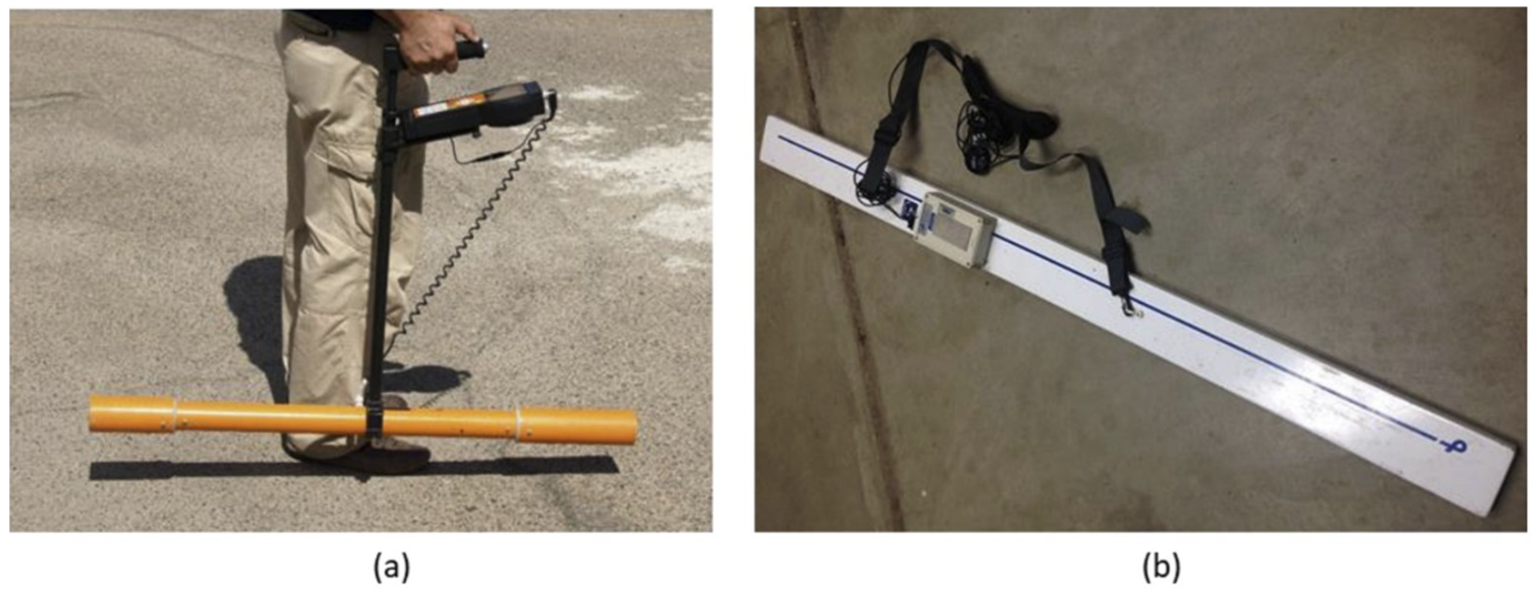
2.3.2. Frequency Domain Electromagnetic Data Acquisition
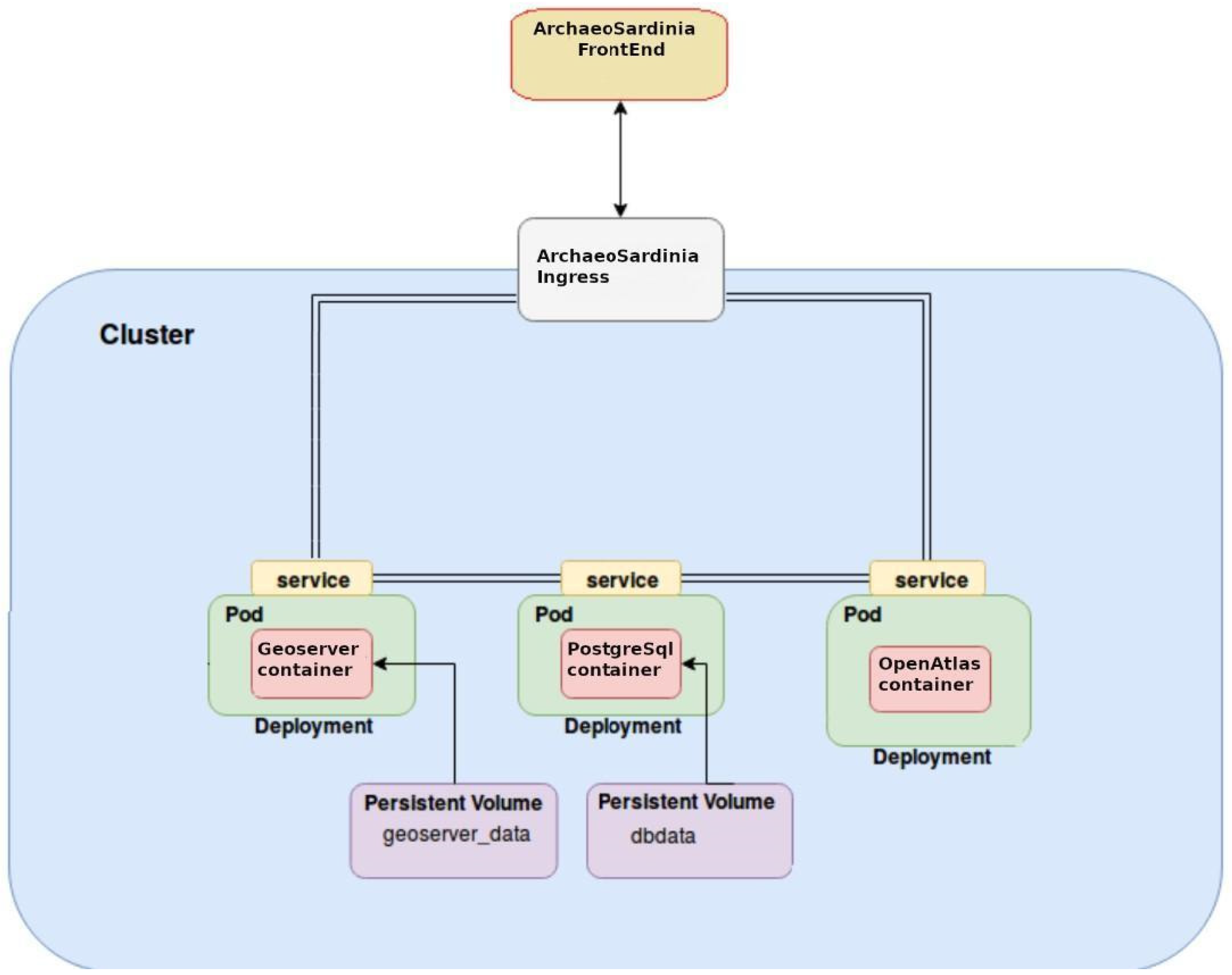
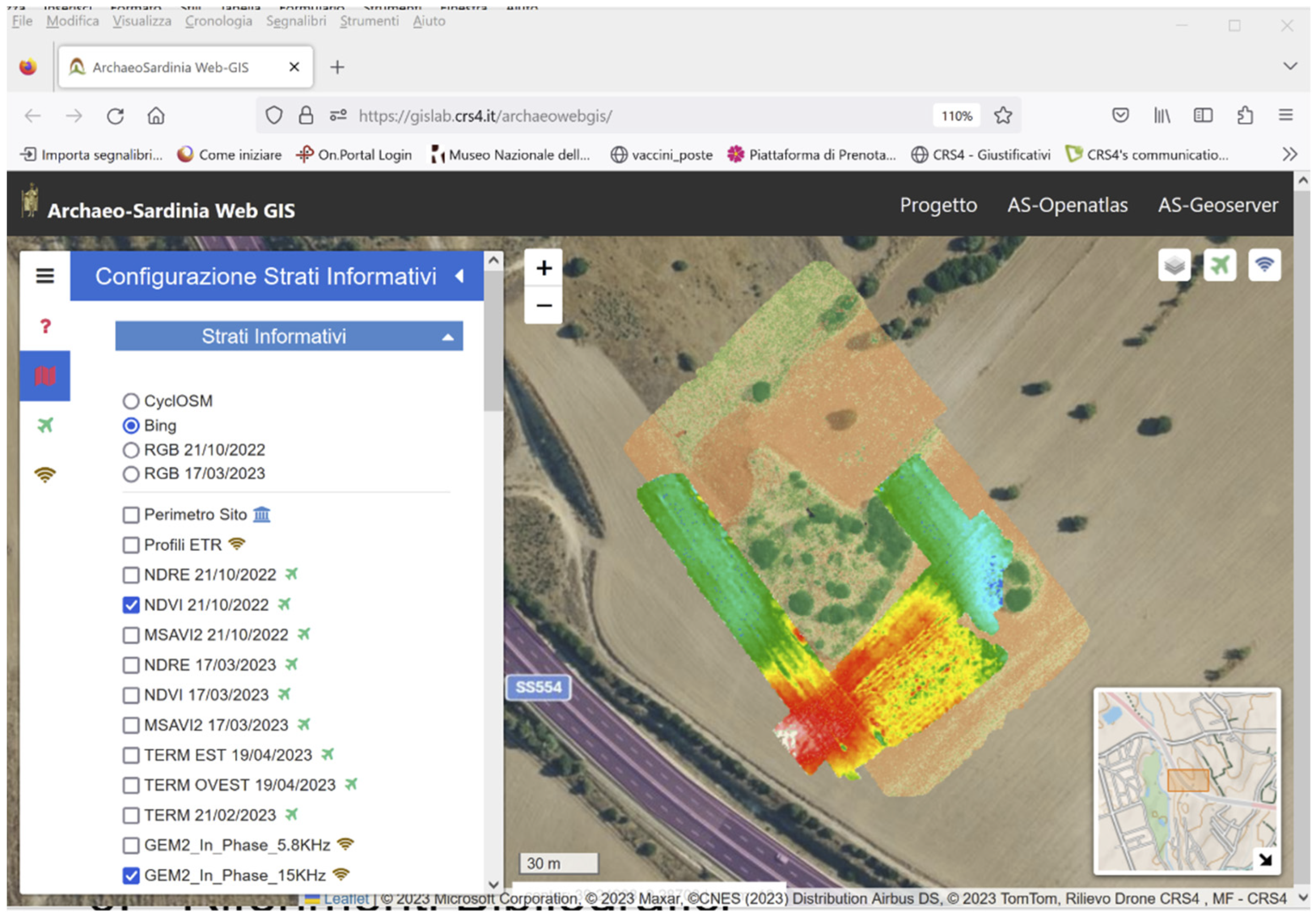
2.4. Data Management and Publication
- ArchaeoSardinia PosgreSQL which handles vector-type GIS data via the PostGIS extension;
- ArchaeoSardinia Geoserver which enables the publication of GIS data. It provides user interfaces to manage the vector and raster data publication;
- ArchaeoSardinia OpenAtlas which enables archaeological metadata management and publication (e.g., documentation of UAV survey and data post-processing methods).
3. Results
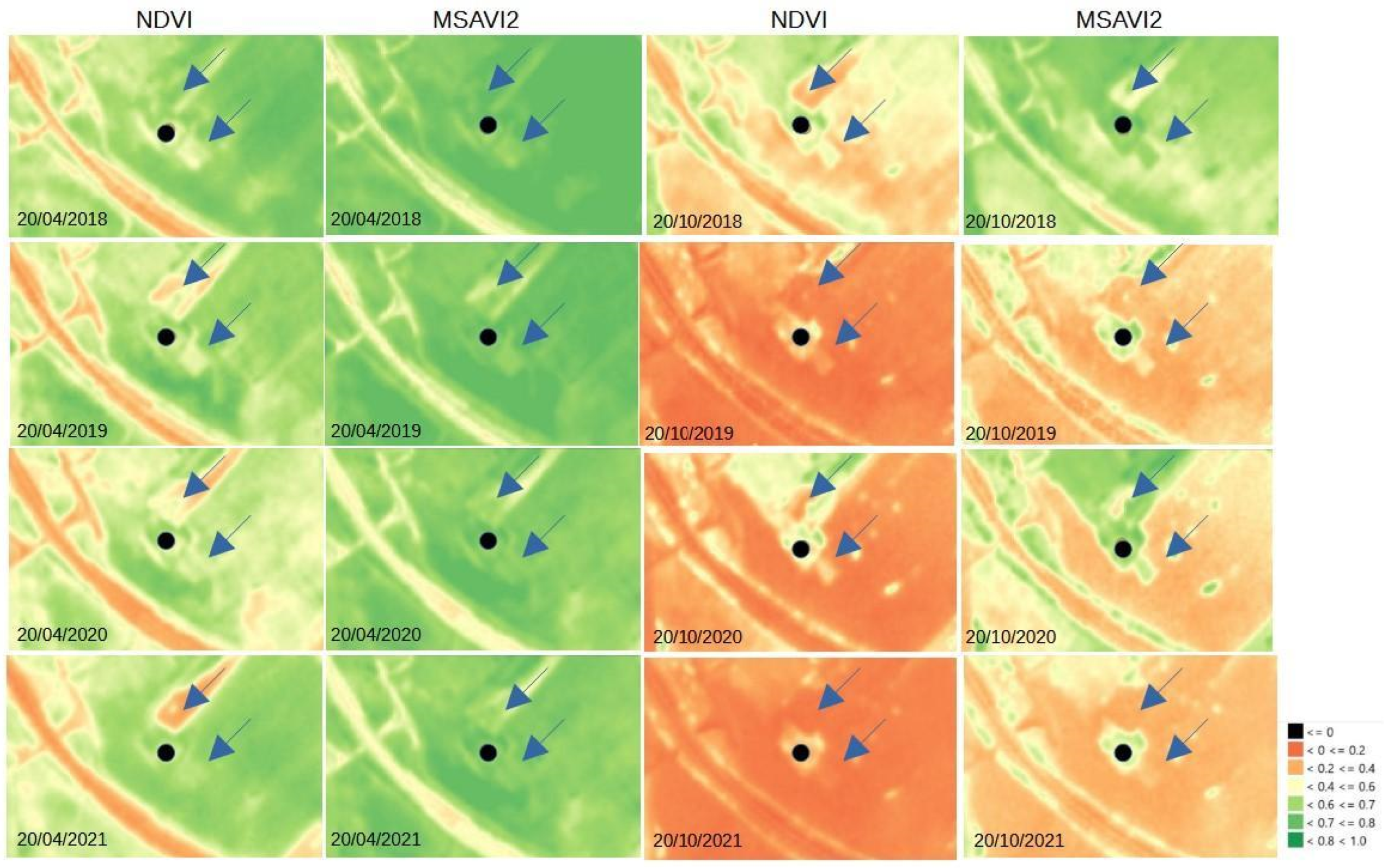
3.1. Analysis of Satellite Images
3.2. Analysis from Drone Surveys
Multispectral Sensor
3.3. Analysis of Geophysical Surveys
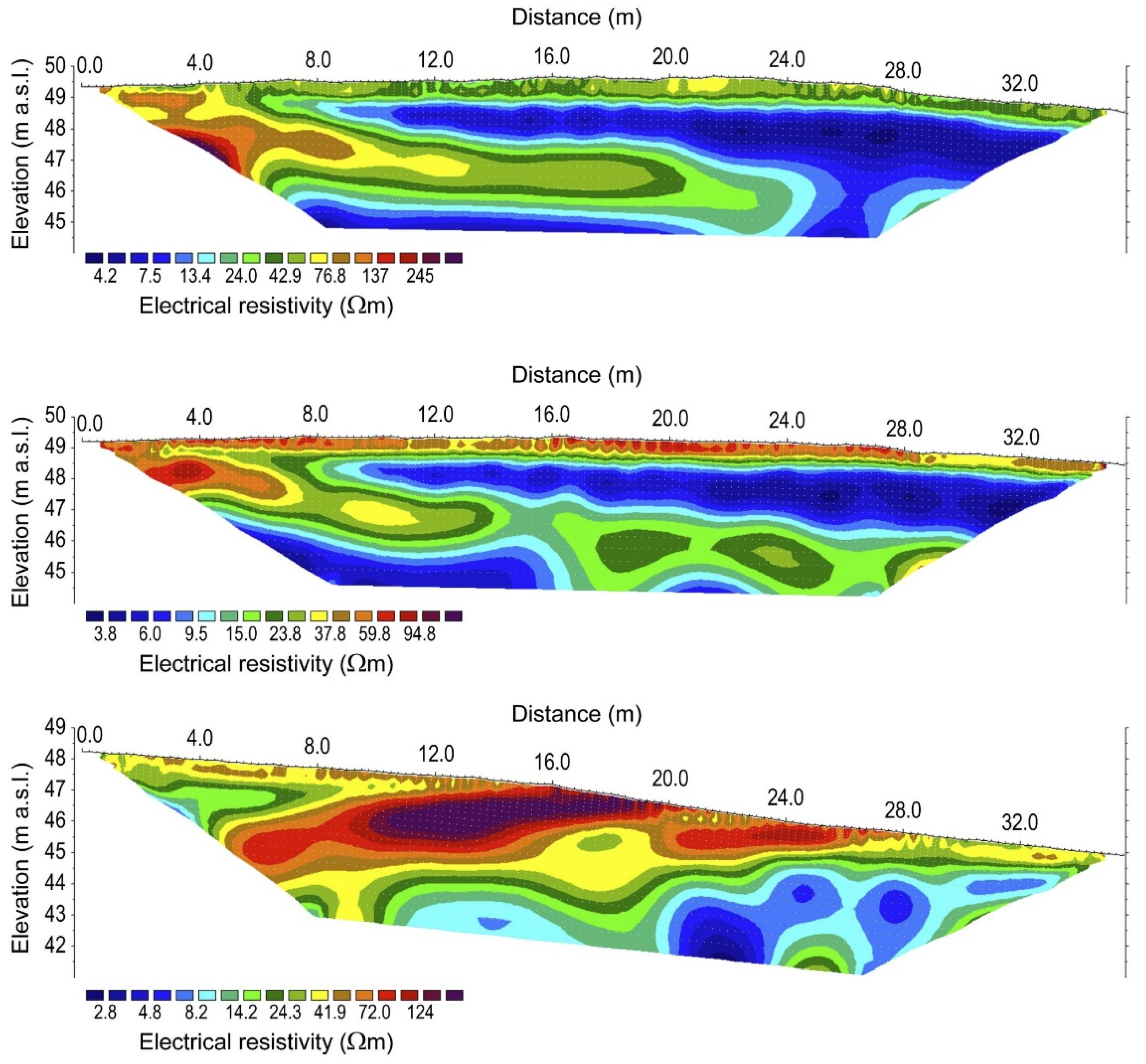
3.3.1. Initial Electrical Resistivity Tomography
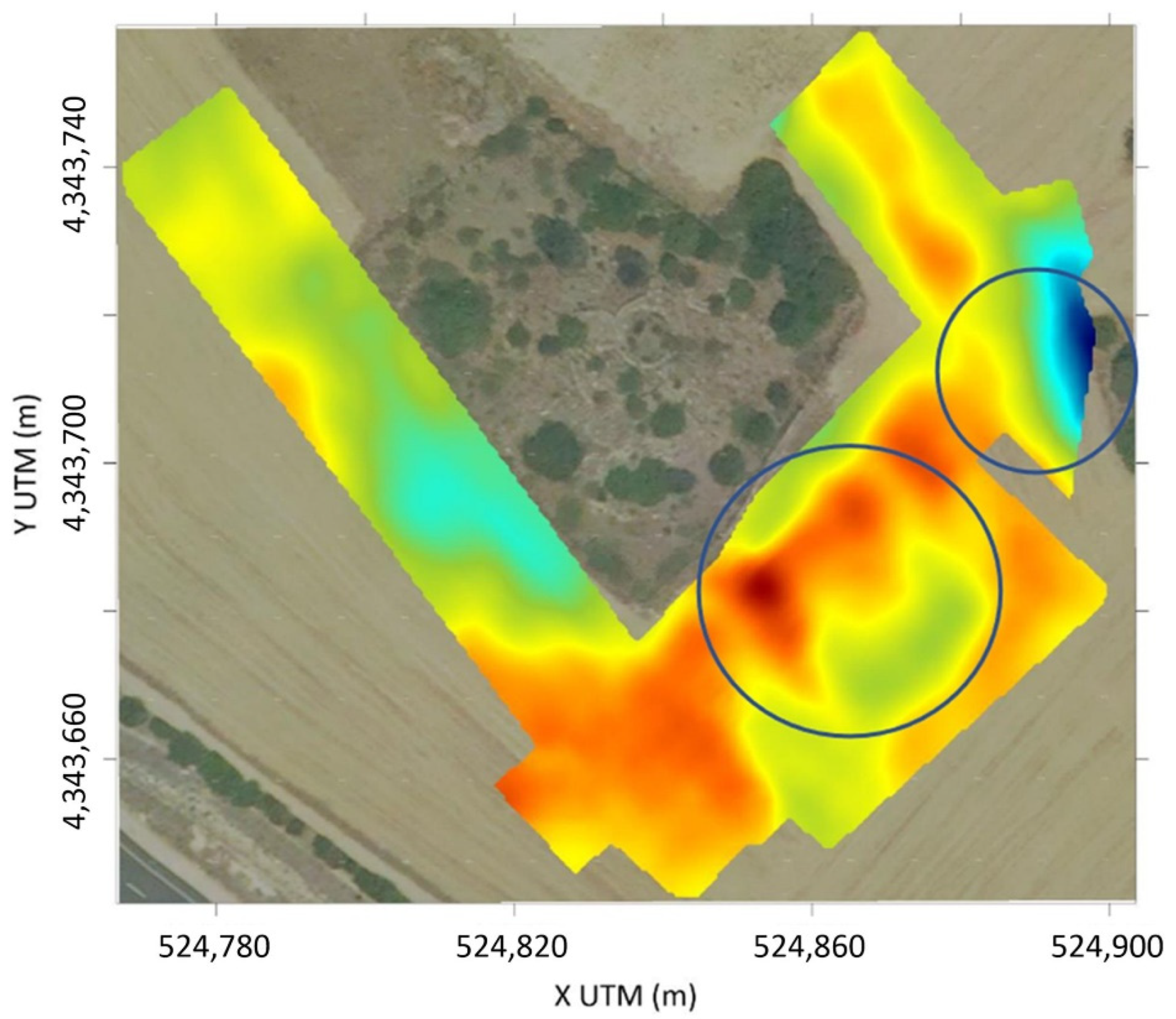
3.3.2. Electromagnetic Resistivity and In-Phase Maps
3.3.3. Follow-Up Electrical Resistivity Tomography
4. Discussion
Author Contributions
Funding
Institutional Review Board Statement
Informed Consent Statement
Data Availability Statement
Acknowledgments
Conflicts of Interest
References
- Spanu, V.; Lorrai, E.; Muscas, L.; Demontis, R. Nurnet-Geoportal. Archeomatica Int. 2017, 8, 26–29. [Google Scholar]
- Demontis, R.; Lorrai, E.; Muscas, L. The Nurnet Geoportal an Example of Participatory GIS: A Review after Six Years. Open Access J. Archaeol. Anthropol. OAJAA 2020, 2, 1–4. [Google Scholar] [CrossRef]
- Cigna, F.; Balz, T.; Tapete, D.; Caspari, G.; Fu, B.; Abballe, M.; Jiang, H. Exploiting satellite SAR for archaeological prospection and heritage site protection. Geo-Spat. Inf. Sci. 2023, 2023, 2223603. [Google Scholar] [CrossRef]
- Fiz, I.; Cuesta, R.; Subias, E.; Martin, P.M. Tests with SAR Images of the PAZ Platform Applied to the Archaeological Site of Clunia (Burgos, Spain). Remote Sens. 2021, 13, 2344. [Google Scholar] [CrossRef]
- Chen, F.; Masini, N.; Yang, R.; Milillo, P.; Feng, D.; Lasaponara, R. A Space View of Radar Archaeological Marks: First Applications of COSMO-SkyMed X-Band Data. Remote Sens. 2015, 7, 24–50. [Google Scholar] [CrossRef]
- Tzouvaras, M.; Kouhartsiouk, D.; Agapiu, A.; Danezis, C.; Hadjimitsis, D.G. The Use of Sentinel-1 Synthetic Aperture Radar (SAR) Images and Open-Source Software for Cultural Heritage: An Example from Paphos Area in Cyprus for Mapping Landscape Changes after a 5.6 Magnitude Earthquake. Remote Sens. 2019, 11, 1766. [Google Scholar] [CrossRef]
- Masini, N.; Romano, G.; Sieczkowska, D.; Capozzoli, L.; Spizzichino, D.; Gabellone, F.; Bastante, J.; Scavone, M.; Sileo, M.; Abate, N.; et al. Non invasive subsurface imaging to investigate the site evolution of Machu Picchu. Nat. Sci. Rep. 2023, 13, 16035. [Google Scholar] [CrossRef] [PubMed]
- Soula, F.; Fallavollita, P.; Zappino, L.; Balsi, M.; Esposito, S.; Melis, M.G. Remote Sensing in Archaeology. The State of the Art and Presentation of METAdAtA Research Project’s Preliminary Results. Rev. Fr. Photogramm. Télédétect. 2018, 216, 61–79. [Google Scholar] [CrossRef]
- Luo, L.; Wang, X.; Guo, H.; Lasaponara, R.; Zong, X.; Masini, N.; Wang, G.; Shi, P.; Khatteli, H.; Chen, F.; et al. Airborne and spaceborne remote sensing for archaeological and cultural heritage applications: A review of the century (1907–2017). Remote Sens. Environ. 2019, 232, 111280. [Google Scholar] [CrossRef]
- Chen, F.; Lasaponara, R.; Masini, N. An overview of synthetic aperture radar remote sensing in archaeology: From site detection to monitoring. J. Cult. Herit. 2017, 23, 5–11. [Google Scholar] [CrossRef]
- Lasaponara, R.; Masini, N. Remote Sensing in archaeology: From visual data interpretation to digital data manipulation. In Satellite Remote Sensing. A New Tool for Archaeology; Springer: Dordrecht, The Netherlands, 2012; pp. 3–16. [Google Scholar]
- Gojda, M.; Hejcman, M. Cropmarks in main field crops enable the identification of a wide spectrum of buried features on archaeological sites in Central Europe. J. Archaeol. Sci. 2012, 39, 1655–1664. [Google Scholar] [CrossRef]
- Alexakis, D.; Sarris, A.; Astaras, T.; Albanakis, K. Detection of Neolithic Settlements in Thessaly (Greece) Through Multispectral and Hyperspectral Satellite Imagery. Sensors 2009, 9, 1167–1187. [Google Scholar] [CrossRef] [PubMed]
- Cavalli, R.M.; Colosi, F.; Palombo, A.; Pignatti, S.; Poscolieri, M. Remote hyperspectral imagery as a support to archaeological prospection. J. Cult. Herit. 2007, 8, 272–283. [Google Scholar] [CrossRef]
- Agapiou, A.; Lysandrou, V.; Lasaponara, R.; Masini, N.; Hadjimitsis, D.G. Study of the Variations of Archaeological Marks at Neolithic Site of Lucera, Italy Using High-Resolution Multispectral Datasets. Remote Sens. 2016, 8, 723. [Google Scholar] [CrossRef]
- Agapiou, A.; Hadijmitsis, D.G.; Alexakis, D.; Papadavid, G. Examining the Phenological Cycle of Barley (Hordeum vulgare) Using Satellite and in situ Spectroradiometer Measurements for the Detection of Buried Archaeological Remains. GISci. Remote Sens. 2012, 49, 854–872. [Google Scholar] [CrossRef]
- Lasaponara, R.; Masini, N. Detection of archaeological crop marks by using satellite QuickBird multispectral imagery. J. Archaeol. Sci. 2007, 34, 214–221. [Google Scholar] [CrossRef]
- Themistocleous, K.; Agapiou, A.; Cusa, B.; Hadjimitsis, D.G. Unmanned aerial systems and spectroscopy for remote sensing applications in archaeology. Int. Arch. Photogramm. Remote Sens. Spat. Inf. Sci. 2015, XL-7/W3, 1419–1423. [Google Scholar] [CrossRef]
- Laugier, E.J.; Casana, J. Integrating Satellite, UAV, and Ground-Based Remote Sensing in Archaeology: An Exploration of Pre-Modern Land Use in Northeastern Iraq. Remote Sens. 2021, 13, 5119. [Google Scholar] [CrossRef]
- Sarris, A.; Papadopolous, N.; Agapiou, A.; Salvi, M.C.; Hadjimitsis, D.G.; Parkinson, W.A.; Yerkes, R.W.; Gyucha, A.; Duffy, P.R. Integration of geophysical surveys, ground hyperspectral measurements, aerial and satellite imagery for archaeological prospection of prehistoric sites: The case study of Vészto-Mágor Tell, Hungary. J. Archaeol. Sci. 2013, 40, 1454–1470. [Google Scholar] [CrossRef]
- Roslan, S.A.; Yakub, F.; Rambat, S.; Noor, N.M.; Saidin, M. The Integration of Aerial Sensing and Geophysical Techniques to Identify Buried Archaeological Properties in Sungai Batu, Bujang Valley. IOP Conf. Ser. Earth Environ. Sci. 2020, 540, 012013. [Google Scholar] [CrossRef]
- Deiana, R.; Vicenzutto, D.; Deidda, G.P.; Boaga, J.; Cupitò, M. Remote Sensing, Archaeological, and Geophysical Data to Study the Terramare Settlements: The Case Study of Fondo Paviani (Northern Italy). Remote Sens. 2020, 12, 2617. [Google Scholar] [CrossRef]
- Deiana, R.; Deidda, G.P.; Dìes Cusì, E.; van Dommelen, P.; Stiglitz, A. FDEM and ERT measurements for archaeological prospections at Nuraghe S’Urachi (West-Central Sardinia). Archaeol. Prospect. 2021, 29, 69–86. [Google Scholar] [CrossRef]
- Gosner, L.R.; Nowlin, J. Approaching Interaction in Iron Age Sardinia: Multi-Scalar Survey Evidence from the Sinis Archaeological Project and the Progetto S’Urachi. Open Archaeol. 2023, 9, 20220320. [Google Scholar] [CrossRef]
- Casari, C.; Demontis, R.; Lorrai, E.; Muscas, L.; Amici, S.; Cannas, V. Investigating spaceborne remote sensing techniques for buried nuraghi structures identification: The Nuraghe Nanni Arrù case study. In Proceedings of the X AIT International Conference, Virtual Event. Cagliari, Italy, 13–15 September 2021. [Google Scholar]
- Houborg, R.; Mc Cabe, M.F. A Cubesat enabled Spatio-Temporal Enhancement Method (CESTEM) utilizing Planet, Landsat and MODIS data. Remote Sens. Environ. 2018, 209, 211–226. [Google Scholar] [CrossRef]
- Bovenga, F.; Refice, A.; Guerriero, R.; Nutricato, R. SPINUA: A flexible processing chain for ERS/ENVISAT long term interferometry. In Proceedings of the 2004 Envisat & ERS Symposium, Salzburg, Austria, 6–10 September 2004. [Google Scholar]
- Deidda, G.P.; Himi, M.; Barone, I.; Cassiani, G.; Casas Ponsati, A. Frequency-Domain Electromagnetic Mapping of an Abandoned Waste Disposal Site: A Case in Sardinia (Italy). Remote Sens. 2022, 14, 878. [Google Scholar] [CrossRef]
- Lavoué, F.; Van Der Kruk, J.; Rings, J.; André, F.; Moghadas, D.; Huisman, J.A.; Lambot, S.; Weihermüller, L.; Vanderborght, J.; Vereecken, H. Electromagnetic induction calibration using apparent electrical conductivity modelling based on electrical resistivity tomography. Near Surf. Geophys. 2010, 8, 553–561. [Google Scholar] [CrossRef]
- Deidda, G.P.; Díaz de Alba, P.; Pes, F.; Rodriguez, G. Forward Electromagnetic Induction Modelling in a Multilayered Half-Space: An Open-Source Software Tool. Remote Sens. 2023, 15, 1772. [Google Scholar] [CrossRef]
- Blanchy, G.; Saneiyan, S.; Boid, J.; McLachlan, P.; Binley, A. ResIPy, an intuitive open-source software for complex geoelectrical inversion/modelling. Comput. Geosci. 2020, 137, 104423. [Google Scholar] [CrossRef]
- Loke, M.H. Tutorial: 2-D and 3-D Electrical Imaging Surveys. 2001. Available online: www.geoelectrical.com (accessed on 15 December 2023).
- Karaoulis, M.; Ritsema, I.; Bremmer, C.; De Kleine, M.; Essink, G.O.; Ahlrichs, E. Drone-Borne Electromagnetic (DR-EM) Surveying in The Netherlands: Lab and Field Validation Results. Remote Sens. 2022, 14, 5335. [Google Scholar] [CrossRef]






| Name | Acronym | Formula | Description | Calculation Method |
|---|---|---|---|---|
| Chlorophyll Vegetation Index | CVI | It indicates the amount of chlorophyll in plants. | Planet Fusion algorithm | |
| Normalized Difference Vegetation Index | NDVI | It indicates the density and health of vegetation. | Planet Fusion algorithm | |
| Modified Soil Adjusted Vegetation Index 2 | MSAVI2 | It is used as a variant to extend the application limits of NDVI to areas with a high presence of bare soil. | Planet Fusion algorithm | |
| Normalized Difference Water Index | NDWI | It identifies vegetation water status, moisture deficit and saturation. | Sentinel2 data | |
| Normalized Difference Moisture Index | NDMI | It indicates vegetation water content. | Sentinel2 data | |
| Moisture Stress Index | MSI | They are used for canopy stress analysis. | Sentinel2 data | |
| Moisture Stress Index 2 | MSI 2 |
| Interferometric Dataset | Constellation | Orbit | First Data Acquisition | Last Data Acquisition | N. Images |
|---|---|---|---|---|---|
| CSK/CSG | Cosmo | Asc | 5 January 2018 | 5 January 2023 | 99 |
| CSK/CSG | Cosmo | Desc | 16 January 2018 | 22 April 2023 | 74 |
| Line | Quadripole | Electrode Spacing (m) | UTM Coordinates Start (m) | UTM Coordinates End (m) | Quota s.l.m Start–End (m) |
|---|---|---|---|---|---|
| ERT_48_A | Dipole–Dipole | 2 | 524,757.9 E 4,343,779.0 N | 524,811.6 E 4,343,702.0 N | 49.4–50.3 |
| ERT_48_B | Dipole–Dipole | 2 | 524,819.6 E 4,343,646.0 N | 524,882.2 E 4,343,716.0 N | 46.0–48.2 |
| Line | Quadripole | Electrode Spacing (m) | UTM Coordinates Start (m) | UTM Coordinates End (m) | Quota s.l.m Start–End (m) |
|---|---|---|---|---|---|
| ERT_72_A | Dipole–Dipole | 0.5 | 524,845.7 E 4,343,678.0 N | 524,866.7 E 4,343,707.0 N | 49.4–48.5 |
| ERT_72_B | Dipole–Dipole | 0.5 | 524,849.5 E 4,343,675.0 N | 524,870.2 E 4,343,703.0 N | 49.2–48.5 |
| ERT_72_C | Dipole–Dipole | 0.5 | 524,888.9 E 4,343,701.0 N | 524,910.9 E 4,343,729.0 N | 48.2–44.9 |
Disclaimer/Publisher’s Note: The statements, opinions and data contained in all publications are solely those of the individual author(s) and contributor(s) and not of MDPI and/or the editor(s). MDPI and/or the editor(s) disclaim responsibility for any injury to people or property resulting from any ideas, methods, instructions or products referred to in the content. |
© 2024 by the authors. Licensee MDPI, Basel, Switzerland. This article is an open access article distributed under the terms and conditions of the Creative Commons Attribution (CC BY) license (https://creativecommons.org/licenses/by/4.0/).
Share and Cite
Muscas, L.; Demontis, R.; Lorrai, E.B.; Heilmann, Z.; Satta, G.; Deidda, G.P.; Trogu, A. Non-Invasive Survey Techniques to Study Nuragic Archaeological Sites: The Nanni Arrù Case Study (Sardinia, Italy). Geomatics 2024, 4, 48-65. https://doi.org/10.3390/geomatics4010003
Muscas L, Demontis R, Lorrai EB, Heilmann Z, Satta G, Deidda GP, Trogu A. Non-Invasive Survey Techniques to Study Nuragic Archaeological Sites: The Nanni Arrù Case Study (Sardinia, Italy). Geomatics. 2024; 4(1):48-65. https://doi.org/10.3390/geomatics4010003
Chicago/Turabian StyleMuscas, Laura, Roberto Demontis, Eva B. Lorrai, Zeno Heilmann, Guido Satta, Gian Piero Deidda, and Antonio Trogu. 2024. "Non-Invasive Survey Techniques to Study Nuragic Archaeological Sites: The Nanni Arrù Case Study (Sardinia, Italy)" Geomatics 4, no. 1: 48-65. https://doi.org/10.3390/geomatics4010003
APA StyleMuscas, L., Demontis, R., Lorrai, E. B., Heilmann, Z., Satta, G., Deidda, G. P., & Trogu, A. (2024). Non-Invasive Survey Techniques to Study Nuragic Archaeological Sites: The Nanni Arrù Case Study (Sardinia, Italy). Geomatics, 4(1), 48-65. https://doi.org/10.3390/geomatics4010003


