
Design Driven Research for Countryside Revitalization of a Rural Settlement of the Fujian Province, China


Department of Architecture and Urban Studies, Politecnico di Milano, 20133 Milan, Italy
Architecture 2022, 2(2), 255-276; https://doi.org/10.3390/architecture2020015
Submission received: 9 December 2021
/
Revised: 29 March 2022
/
Accepted: 2 April 2022
/
Published: 7 April 2022
Abstract
:Countryside development is receiving paramount attention in China, where political and cultural agendas promote rural revitalization as the core campaign to mitigate rural–urban disparities. The driving idea is that the rural can emancipate from its agricultural dependence to embrace more complex and integrated cycles of activities, such as leisure, health, productivity, market, and cultural services. The momentum reached by rural development in China has opened a new dimension for contemporary design culture, where the countryside has materialized as a frontier of architectural research. The paper synthesizes research by design experience carried out between 2017 and 2020 against the backdrop of the development program for a rural settlement of the Fujian Province, China. From the site reading to the experimental transformation proposal, the different phases offer sparks and arguments to put forward new understandings of designing in transitional rural contexts.
1. Introduction
China is considered to be halfway through its urban transition, a long-term process that has been reshaping its land’s tangible and intangible attributes. One of the consequences is the irrevocable dissolution of the categories of the “urban” and the “rural.” What role the architecture can play in these kinds of transitional geographies molded by developmental logic of neoliberal urbanization remains a key question in current design studies [1] (p. 45). This paper looks at the transformations taking place in ruralities, where land-use regimes have experienced unprecedented pressures over the recent years. Here, the ongoing socioeconomic transition is shifting the spectrum of values animating the peasantry, generating frictions between what was inherited from the past and what is demanded for the future. Rather than a linear path, Chinese rural and peri-urban territories are witnessing a controversial process of transformation, where both over planning or designing and lack of planning or designing contribute to the erosion of Chinese society’s identity values. Recent decades saw entire settlements and ecosystems left to uncontrolled negotiations and discontinuous courses of crisis and development, whose aftermaths have included economic backwardness, social inequality, land-use pressure, food insecurity, environmental instability, and cultural loss. Indeed, a frequent outcome of rural development programs has been the demolition of ancient buildings, in many cases of whole settlements, and the consequent neighborhoods’ construction with denser built forms, where entire communities have been relocated. Alongside numerous upgrading of life conditions, such practices have occasionally contributed to sharpening socioeconomic disparities.
Against the backdrop of a fast-evolving situation, the question of rural development imposes a profound reflection on the modalities of site modification and the recycling of spatial resources by means of architectural design. This paper is situated in this conjuncture and takes a design experience for a remote village in the Fujian Province to discuss a development approach based on the valorization of the existing territorial assets. It questions how architectural design can build common transdisciplinary grounds, acting as a leading field to coordinate and inform sites modification. The results show a strategy of transformation alternative to massive razing and reconstruction—as envisioned in previous planning schemes for the same village—where the rationale of punctual interventions emerges as a multiscalar tool targeted to activate, protect, and enhance land portions.
2. Literature Review
2.1. Recent Positions on Architecture for the Rural
The question of what future can be envisioned for countryside areas worldwide has been formulated countless times over history. As a complementary realm with the urban, the rural has almost always been put as a societal infrastructure mainly operating at economic and political levels. A state of affairs of theoretical rural discourse was proposed in 2006, framing epistemological approaches and new developmental challenges [2]. A few years later, from his geographical observatory, Woods put the rural as a relational structure integrating complex and diversified realities [3]. From the perspective of design studies, the rural has received growing attention recently. In 2006, Ballantyne conceptualized architecture as a place-making tool operating between the two complementary urban and rural fields [4]. In 2018, Carlow collected contributions posing the question of how architecture and planning could positively play a role in countryside development [5] and, in 2020, the AMO group provided a vibrant picture of ruralities’ spatial conditions worldwide [6]. Polish participation at the 2020 Biennale of Architecture in Venice, postponed to 2021, again put the countryside at the center of the debate with a curatorial project calling for a critical rethinking of communal forms of living in post-communist national ruralities [7]. What emerged from the curators’ arguments is the idea of the countryside as a “sensitive network” [8] (p. 247), reciprocally shaping with cities the territory of communities. Their inquiry dismantled the static dimension of the rural as an urban counterpart plundered by colonialist behaviors or capitalistic mechanisms. At the same time, even recognizing the violent breakdown brought about by the Polish socialist order, they were able to trace paths of communities’ solidarity, interlinking relations, and sense of belonging, bringing them to the audience’s attention without making nostalgic complaints. Either as a political project or as a context where more freely practicing architecture compared to the urban, the countryside has been framed as a space for potentially forging new hybridized identities, released from the burdens of obsolete definitions of urban and rural. Indeed, as noted by Koolhaas [9] (p. 2), in front of a “predictable accumulation of roads, towers, icons” featuring new cities, the countryside has become a source of site identity.
2.2. The Rural as a Frontier of Architectural Expression
In China, where a large part of the real estate industry has flattened urban complexities, laying on the land a huge amount of generic built forms [10], the countryside has offered architects the possibility of more freely practicing personal sensitivities and understandings of contemporary design. Chinese ruralities have, therefore, represented a frontier of architectural expression and, also due to fewer restrictions than those imposed in urban sites, have granted designers the possibility of undertaking innovative approaches and unexplored paths. Their participation has varied from the urgent needs of post-disaster reconstructions or socioeconomic restructuring and retrofitting to the dream of building a Beautiful China [11], which became the slogan synthesizing a variety of transformations targeted to ameliorate the condition of peasants. Zhang’s book, together with the curatorial commitment at the 2018 Biennale of Venice [12], the seminal work by Rural Urban Framework [13,14,15,16], and the plethora of design practices operating in the countryside [17,18,19] have unpacked a multitude of architectural experiences that are reshaping the cultural dimension of designing in remote or marginalized areas. On a broader scale, many examples have reached public attention as well. Two complementary strategies are worthy of mention: one based on punctual transformations in complex settlements’ systems and the other on new rural neighborhoods and towns projects. The first is the rural revitalization program promoted by local governments in the Songyang County of Zhejiang Province, where Xu Tiantian applied an urban acupuncture plan that encompassed several villages [20]. The second grafts on the idea of designing hybridized settlements featuring both rural and urban attributes, engendering new densities and atmospheres able to respond to both the political agenda and the villagers’ dream of social emancipation. The projects formalized by Lee’s students at Harvard show the potentialities of radical, sometimes provocative, yet intelligent approaches to the quest for imagining new foundation towns [21].
2.3. Key Points of Chinese Rural Development Discourse
Since the 2000s, after Wen Tiejun enucleated the three rural issues, packages of policies to repay the countryside have been released, following the pace of five-year plans, such as Building a Socialist Countryside, Beautiful Village, and Rural Revitalization Strategic Plan 2018–2022 [22,23,24,25,26,27,28,29]. Concerns over local cultural continuity to broader social and environmental sustainability have sustained a lively international debate. On one side, a branch of studies has investigated how cultural resources have influenced developmental policies and practices. For instance, heritage discourses have contributed to pave the road for a profound process of rediscovery of pre-revolutionary roots, ancient traditions, and local folklore [30]. The “heritage fever” described by Blumenfield and Silverman [31] has often instrumentally served socioeconomic and geo-political projects under the aegis of a “cultural diplomacy” [32] (p. 57). A paradigmatic example is the Belt and Road Initiative, which embodies China’s physical and spiritual vision as a hegemonic player on the international chessboard. Cultural continuity has been promoted to forge a cohesive national identity and legitimize a political strategy of development [33,34,35].
Another branch of studies has examined the subaltern condition of Chinese peasantry compared to urban citizenship [36,37,38], most of which have emphasized how the social divide has endlessly alimented internal migration toward cities [39,40,41]. While some have described rural societal evolution [42,43], others have explained how rural–urban dichotomies have affected people’s living conditions [44,45], as well as spatial configurations [46]. The possibilities of grassroots rural development have been experimented in several villages. A fortunate case is Bishan, which received theoretical and practical guidance from activist Ou Ning. Since 2011, the Bishan commune project has endorsed historical preservation, cultural production, and public life in the village. The large participation by artists and intellectuals blossomed into a new cultural network exploring how contemporary cultures could meet local folklore and boost village revitalization. Year after year, cultural events and festivals received institutional recognition and became a forum where social activists had the chance to discuss and share their experiences about topics such as environmental protection, community-supported agriculture, rural economic cooperatives [47,48,49].
In 2018, the realization of an Ecological Civilization was written in the Constitution, upgrading the national ideology on environmental discourse and policymaking [50,51,52,53,54,55,56,57,58], and shedding new light on contemporary practices of rural development. Even though China’s green turning point may appear far from a socially and ecologically sustainable development model, it still represents one of the most ambitious programs tailored to mitigate social inequalities and achieve carbon neutrality. Such a long-lasting program will last for decades, and international observers will have to wait to fully assess practical results and impacts. Nevertheless, the ideological mobilization envisioned by this campaign is paving the road for a softer and brighter integrated development, which may contribute to generating new understandings of rural development via design agencies.
3. Case Study and Methodology
The case study is Zhangyang Village (Xinxian County, Hanjiang District), a rural settlement of the Fujian Province connected with Putian City by a single one-hour-drive road (Figure 1). The site is located not far from the west bank of the Taiwan Strait, on the north edge of the Tropic of Cancer, and is one of the coastal economic open areas. It has a typical subtropical maritime monsoon climate with abundant sunshine. The annual average temperature varies from 16 °C to 21 °C, with long and hot summers and short and mild winters. The average annual rainfall is 1.288 mm, decreasing from the northwest mountainous areas to the southeast coastal ones. Due to uneven annual precipitation, droughts during spring and autumn often occur. The average annual sunshine hours is 1.600 h, and the sunshine rate is about 36%. The variation of sunshine hours in different seasons is small, contributing to the growth of crops and fruit trees. The main directions of the monsoons are the northeast winds, but seasonal variations usually take place.
About 1.400 people live in Zhangyang, with more than one-third commuting to large cities for work, and forecasts provided by the local administration expect a slight growth in the years to come, reaching 1600 in 2030. The village lies in a small plain surrounded by hills covered by woodland. It is crossed by a stream, Xiangxi river, which gently turns to create idoneous space for wetlands, drenched by several irrigation ditches (Figure 2). Zhangyang’s spatial layout is consistent with the principles of fengshui, the traditional geomancy based on ancient rites mixing complex calculations and ancestors’ divination. For instance, the sequence of mountains delimitating the plain is believed to protect the village from the northern evil winds. Every elevation is associated with a sacred spirit: the qinglong (azure dragon, east, left), baihu (white tiger, west, right), zhuque (red bird, south, front), and xuanwu (black tortoise, north, back) (Figure 3) [59,60] (p. 78). The sections centered on the river show two peculiar aspects. First, the watercourse divides the plain into two parts, where buildings and croplands are displaced in accordance with topography slopes and hydrological risks. Second, the four little mountains mentioned above constitute the plain’s visual borders and determine a character of closeness that echoes the idea of a large room surrounded by natural walls. The relationships between these natural elements mark the uniqueness of the settlement (Figure 4).
Han people have settled in Xinxian County since the Song dynasty, precisely since 979 A.D. [61]. The age of Zhangyang Village is not known by its inhabitants. One possibility is that, like other villages, its land was first occupied after the evacuation of Putian’s plain. Indeed, since the beginning of the XV century (1410–1563), the fertile Putian plain had been attacked by pirates, resulting in several thousand casualties (150,000 estimates) [62] (p. 102). At present, Zhangyang exposes similar characteristics to many other villages, where a visible socioeconomic stratification gives form to a diversified built environment. The local taste has blended disparate types of decorations ranging from pseudo vernacular motifs to Western-like codes freely pulled over, such as classical moldings, Greek-style tympanum, or baroque loggias, grouped in bizarre ways. Walking along one street, one finds oneself immersed in the typical patchwork of shapes that characterizes rural settlements in southeastern coastal regions (Figure 5).
The adopted methodology uses analytical observations and graphic elaborations to envision design actions alternative to large demolitions and reconstructions. Four phases inform the design process: the interpretative site reading, the investigation of the building stock’s conditions, the strategy of transformation, and multiple tactical actions. Particular attention is paid to the polysemic nature of the built fabric, whose morpho-typological structure and formal attributes condense historical layerings, economic forces, cultural manifestations, and transformative practices [63].
4. Design-Driven Research
4.1. Site’s Reading
From a peripheral point of view, the built fabric of Zhangyang appears a dense mass with clear borders, almost consolidated. It is penetrating its interior parts, and one could realize how the multitude of scattered multistorey villas fragmented the open space. Walking along any street, one could see the built fabric heterogeneity, featuring spaces organized in linear concatenations and dispersed clusters (Figure 6). These two aspects coexisted chaotically, mainly because houses’ construction has lacked coordinated design, leaving initiative in the hands of landlords. They built their new villas without considering spatial relationships with the surroundings and following the conveniences offered by the terrain. These relatively tall buildings lay dispersed without apparent morphological criteria and generated continuous variations of streetscape proportions, which let the natural scenery enter the spatial experience of a walk in the street. In most cases, landlords overbuilt, erecting houses that exceeded the space required by the family, leaving the last floors empty or even unfinished. The vacant rooms have been used basically during holidays and festivals, when family members are used to gather in the native village. Most freestanding houses—entitled boxlike villas by Ronald Knapp [64] (p. 6)—lay in the middle of concrete-paved private yards, fenced by walls, which generated distances between the buildings and the streets and, ultimately, compromised the streets’ public space continuity. Immersed in these chaotic patterns, some nuclei defined by recurrent measures, intervals, and regular-shaped open spaces emerged as spatial invariants. These ensembles of vernacular buildings, which mix domestic, ritual, and working spaces, were determined by clear geometrical rules. Their spatial characters constituted a distinctive feature, embodied by the unique relationships they created with the landscape [65]. By observing the site plan, we can recognize how the interferences between these agglomerations and the street network perform as the structure of the whole settlement. This void form condenses spatial and social relations, engendering a lively overlap of uses, similarly to the space of contact described by Françoise Choay in some ancient towns of France [66]. Figure 7 synthesizes the steps undertaken to study the village’s morphology. Top-left diagrams illustrate the consistency of the built fabric representing figure-grounds maps, the borders’ perception from outside and inside, the actual street network, and the spatial invariants in terms of measures, proportions, and alignments. Below, the two main uses of the open space were mapped: private yards and small vegetable gardens, named micro-agriculture. On the right, the figure shows the real space of relation, deprived of private uses, such as yards or vegetable gardens, where people can circulate and interact. At the bottom, the pictures show the diversity of the village’s public space, where one can find marked compactness (left) and total openness after a few steps (right). Vernacular ancient buildings and recently realized villas follow one another abruptly, materializing incoherent formal and material juxtapositions and disharmonic spatial transitions (Figure 8). The portion of fabric considered for the design experiment is comprehended by a street ring and a broken network of internal paths connecting with agricultural fields and other village parts. Two aspects can be detected. On the one hand, this area exposed several issues ranging from land idleness, buildings vacancy, lack of care, and lack of a system of public spaces. The result was a chaotic addition of private yards, curvy trails, decaying shacks, destroyed buildings, and spontaneous vegetation [67]. On the other hand, the area featured some potentialities, such as the presence of ancient buildings, which could be turned into cultural assets, and several scenic spots that offered emotional views of the landscape.
4.2. Building Stock’s Conditions
A decisive methodological step was to produce an updated picture of the building stock’s conditions. During the fieldwork, a survey including original first-hand data was drafted to analyze the status of the constructions. The selection criterion of the sample was based on functional use. Consequently, houses or buildings showing clear evidence of residential use in the past were comprised, while structures used for agriculture, livestock, and poultry, such as shacks, barracks, and canopies, were excluded. The seven temples and the two school buildings were not counted as well. Even though the fifteen ancestral halls were partly used for living, they were excluded, since they exposed utterly different features in their spatial composition and use, demanding other types of considerations. The sample encompassed 292 residential buildings, which constituted the largest part of the village’s built form. From investigating dwellings separately (Figure 9), the survey led to the formalization of thematic mappings and datasets framed according to eight parameters, namely number of stories, building’s period, technology, condition, use level, lineage, typology, and presence/absence of volumetric additions. The datasets included a matrix of buildings parametrized with numeric values and supported by pictures and notes. For the purpose of this paper, only two parameters are considered here: dwellings’ condition and use level.
Dwellings’ condition ranged from ruin to good condition (1 = ruin, 2 = heavily damaged, 3 = partly damaged, 4 = little maintenance, 5 = good condition). Ruin meant a structure where it was not possible to live anymore. Heavily damaged meant a building with severe deterioration regarding the roof or the windows. The reparations required invasive actions and possibly the substitution of whole parts. Considering the climate of Fujian, it was possible to live inside, but the conditions were under minimum decency level. Partly damaged meant a building with more than one corruption affecting the lifestyle quality but not massive damage. The reparations required restoration actions without substantial changes. Little maintenance meant a building that was working properly with little damage, which mostly related to its appearance. It required modest actions or cycles of ordinary maintenance. Good condition meant that the building was working properly, ensuring good lifestyle quality and showing no reasons for repair. The use level was expressed with three categories (1 = abandoned, 2 = occasional use, 3 = continued use). Abandoned referred to buildings in disuse; occasional use to those buildings with evidence of a discontinuous usage; continued use to regularly inhabited buildings.
The results of this survey showed where, how, and how many buildings were facing problems of vacancy and lack of maintenance (Figure 10; Table 1). The most problematic ones were concentrated in the core part of the settlement, manifesting villagers’ preference for moving into newly built houses placed in the fringe areas. Householders abandoned old dwellings or turned them into warehouses, ceasing ordinary practices of maintenance. In some cases, buildings in relatively good condition were also evacuated because landlords had migrated to urban areas. Similar assessments have also been implemented in other research works demonstrating the spatiotemporal evolution of village hollowing, a phenomenon recurring in rural China since the 1900s [68,69,70]. These data played a determinant role in formalizing a design strategy that operated on multiple scales. It responded to actual criticalities exposed by the building stock by fielding a rigorous method based on site observation that encompassed the whole village. It also permitted the coordination of punctual actions according to emerging priorities, envisioning a transformation process organized in temporal phases.
4.3. Development Plans
Since 2014, the development of Zhangyang has been subject to a Province-driven program conceived as a long-term path toward rural restructuring. In 2015, the Fujian Province Village Town Construction Development Center, a local state-owned enterprise, drew up the village’s planning, defining the project’s goals, modalities, and forms. The document included several elements. Its legal framework clarified the program’s position in relation to the central, provincial, and municipal regulations, as well as the contextual planning for the district and the county. The document listed the project’s generalities, such as the scope, the period, the expectations, and the guiding principles. It also contained detailed implementation modalities, including the existing condition, the new land-use plan, the infrastructural plan, the structural retrofitting, and the short-term village transformation. According to the planning prospect, the driving principle was land consolidation to optimize local farming techniques and productions and implement a service industry able to inject new life into the current depressed economy. The construction land expansion had to meet the village population’s expected increment, which was supposed to reach 1.600 by 2030 from the current 1.426. The planning’s main features included massive demolitions and re-building with higher construction indices, generating an increased fabric density. The project provided new infrastructure and facilities, proposing multiple retrofitting: seismic, energetic, sanitary, and functional. Beyond strengthening the farming industry, the goal was to introduce new economic sectors, notably crafting and tourism. The design report claimed more space between the buildings in response to the difficulty of adding houses in the interstitial spaces. Demolitions and reconstructions had to start from the village’s central area and conform to a rigid grid-based layout. The final image had to produce a “unified style”. The newly built fabric was drawn over the same sediment of demolished buildings, rectifying irregularities and concentrating the volume in rows of bi-familiar villas, sometimes detached. The rendering reproduced similar little town atmosphere seen in other compounds recently realized.
This previous proposal exposed some controversial points. First, the rate of demolitions was so high as to infringe on sustainable criteria. Second, even assuming bulldozing as a necessary action, the repetition of the antecedent spatial configuration appeared to be pointless. The documents reported no reasons to erect the new buildings in the same position and with almost the same orientation as the old ones, which resulted from spontaneous initiatives. Curiously, the planning did not include the design of one recognizable public space for shared activities able to meet current demands and adapt to future uses according to the development prospects. Third, the project replicated ad libitum three housing typologies, generating a built form redundant in its architectural connotations and indifferent to the site’s peculiarities. The middle-rise buildings were furnished with little gardens in front of the main entrance. They exposed an awkward combination of traditional and exotic decoration, ultimately similar to the villas constructed by landlords independently. From the renderings, the ancient vernacular houses appeared re-built with the same forms but modern materials according to a stylistic reconstruction. In 2017, Zhangyang Village authorities started a consultation process with the Shanghai Jiao Tong University, in partnership with the Politecnico di Milano, to work out an alternative plan guiding the village’s development. The interactions between local authorities and research groups were aligned with the benchmarks of the national Strategic Plan for Rural Revitalization 2018–2022, which encouraged the realization of demonstrative projects and cooperation with scientific institutions. Zhangyang obtained the possibility of revising the planning to be enlisted as a pilot project without substantially altering the old plan’s vocations to become a service hub integrating leisure activities and technological innovation. The pilot project for Zhangyang Village was situated in the larger plan to make the Fujian Province one of the experimental zones with demonstrative purposes. Since then, a new approach to development was put in practice, deviating from the previously envisioned tabula rasa methods. Villagers were consulted through listening practices of listening and grassroots proposals. Reparation works began from securing the river banks, and the development is still in progress.
4.4. Experimental Design
The experimental design offered the opportunity to define the methods and techniques to establish rigorous coherency relations between the conditions detected on site and the development prospects. The main purpose was protecting and possibly enhancing the settlement’s landscape dimension, which was seen as the most valuable asset. Therefore, the project defined two types of hierarchical actions. On one side, it established an inclusive strategy, setting the main principles of transformation, such as defining coordinated systems of circulation, public space, service offer, resorting to minimum interventions, and implementing circular economies. This strategy was grounded in the buildings’ stock condition disclosed during the surveys described in Section 4.2. Table 2 reports the main data about houses’ physical condition and use level, assigning timing priorities based on the urgency of each action. A spatiotemporal program of actions was thus formalized, synthesized in a strategic diagram (Figure 11). On the other side, it envisioned tactics that give substance to the overall idea, endowing specific circumstantial conditions. For instance, actions of recovery, reuse, restoration, adaptation, demolition, and reconstruction were orchestrated as part of the overall scenario, varying in terms of implementation scale, timing, and modalities. The attempt was to avoid unnecessary demolitions, especially in terms of the traditional buildings realized in rammed earth and timber carpentry, which exposed severe issues of structure, climate control, and functionality, distributed across the whole building or localized in some portions. The easiest solution would have been to simply bulldoze and replace. Conversely, the proposal differentiated four main design actions for each issue encountered (Figure 12), addressing the buildings’ functionality, static, and performance. The first column represented those buildings showing functional problems regarding the capacity to fulfill basic needs. In this case, the tactic suggested retrofitting and reusing the existing structures, acting on the re-functionalization of the building. Technical elements could be inserted inside the volume to meet the demands of contemporary uses and comfort performances. The second column epitomized those buildings with the same problems as those of the first column but with the urgency of replacing one or two structural elements, such as a collapsed roof. The tactic envisioned the same actions, with the replacement of the damaged element and the recycling of waste materials. Some buildings showed multiple structural problems localized in some portions. For these circumstances, column three indicated a partial demolition with the recycling of waste material and reconstruction adopting contemporary design criteria. This tactic opened various possibilities of interaction between the new and the old in terms of form, materials, and atmosphere. Some buildings had almost crumbled, preventing any reasonable form of recovery. Column four suggested their dismantling, recycling of waste material, and, if necessary, construction of a new architecture designed with contemporary criteria.
The area selected for testing these strategies and tactics was intercluded between a dense portion of built fabric and farmland. The site has been the theater of recent transformations, with the new road designed as a rigid axis cutting crop fields and a set of new facilities added in correspondence with the village’s main street, where a new pavement and a pergola for public use have been constructed. The main idea was to consider this part of the village as a cultural platform that integrated existing elements—where the ancestral halls were most important —with new ones, including activities for both inhabitants and visitors, such as commercial, trading, art crafts, leisure, and art spaces. This cultural platform also provided the village with a new area for events, such as the Harvest Festival that since 2018 gathers hundreds of people every year during the mid-autumn Festival week. The first editions of the festival took place in a temporary lot flanking the stream, which, being distant from the village’s core, negated spatial relations between visitors and inhabitants, beyond occupying valuable arable soil near the watercourse. The new area for events could be positioned closer to the built fabric to interact more with the village’s public space and be used the whole year. The design criteria for all these actions included recognizable interventions to show the historical layerings sedimented over time. Buildings’ demolitions and reconstructions were balanced to maintain similar fabric density, yet, at the same time, to introduce more flexible configurations. Figure 11 illustrates how the existing ancestral halls determined the two main directions orienting the new spatial setting. This principle ensured the achievement of a morphological continuity with the traditional architectures by adding a canopy and small pavilions with simple typological schemes. It also individuated a convenient site to give form to an ample public space connected with the new road and adjacent to the built fabric. This place, situated at the edge of the settlement, was supposed to resolve circulation issues thanks to the connection with the new street and to provide the village with flexible public spaces, idoneous to both hosting temporary activities and carrying out daily activities. Given its strategic position, this public space also served as a scenic spot to contemplate the surrounding landscape.
4.5. Design Outcomes
The development of this experimental strategy was formalized in a master plan, a ground-level plan, two sections, and two evocative collages simulating the new atmosphere. A crucial aspect was the open space design, defined in its formal and material attributes and the spatial interactions with adjacent buildings and pedestrian networks. The new canopy was the barycentric element of the overall configuration. Providing shadow and protection from rainwater, it offered a pausing moment in the sequence of public spaces where people could admire the natural scenery and carry out daily business. This structure was conceived as a multi-functional and technological element hosting digital infrastructures and lightning systems. At the same time, it had to create a counterpoint with the traditional timber carpentry present in nearby vernacular architectures. The other pavilions were intended to be realized with traditional raw materials cast on site with contemporary techniques, attempting a material dialog with the surrounding vernacular buildings. The new pavement identified a flexible space where various situations could occur and facilitate social interactions. Its squared shape was intended to reorganize the village’s edge in a way that the existing fragmented and disarticulated morphology could be recomposed by emphasizing new hierarchical relationships (Figure 13). The façades of the adjacent ancestral halls gave material presence to one of the borders and stimulated a spatial dialog between historical and contemporary artifacts. In case of necessity, cars could use the parking area traceable in the stone pattern of the square when the platform was not used for crowded events. The largest pavilion, two floors high, was conceived as a full–empty–full sequence of spaces to be directly connected with the front open space, as a continuation of the street inside the building. On the second floor, the scheme was repeated with a double height in the middle. The overall blueprint tried to harmonize the existing elements working on the continuity of public grounds, as a system alternating uses and materialities, where heterogeneous activities or relaxing areas could couple with circulation, engendering a new esthetic experience (Figure 14).
5. Discussion
The reconfiguration of the system of public spaces is a predominant element of the project. Resorting to minimum intervention, it synthesizes multiple aspects, condensing multiscalar relationships and hybridizing uses and forms according to rationales of flexibility. As synthesized in the site reading, the existing public space condition exposed ambiguous but interesting connotates. For instance, if we exclude those fenced by impenetrable walls, private yards often melted with roads, pavements, and created continuous enlargement and narrowing of the street section. Some of these interstitial open spaces had characters of interiority that resembled rooms open to the sky (Figure 6). With a few steps, one could walk from these intimate open spaces to lanes bordered by vegetable gardens or inside clusters of buildings that framed the scenery toward outside, experiencing different types of landscapes. The boundaries between private and public shaded, and one could see how peasants used streets’ portions to dry vegetables, fix utensils, or carry out domestic business, animating the public life of the village. The proposed design tried to protect this atmosphere, reinforce the system of circulation paths, and give full play to serendipitous interactions between people’s activities and spontaneous built forms. The square reconnected scattered fragments of public spaces and suggested new meanings without really changing too much the existing setting. Figure 15 shows the new public space system, defined by clear spatial hierarchies, which let the different portions of the rural fabric play together and redefine spatial relationships. The squared open space was an intersecting point between the two realms of the village: the compact fabric and the vast cropland surrounded by green hills. This favorable condition had two consequences: to let the public space work as an invisible threshold and increase its adaptability to evolving needs. Its shape was derived not from formalistic attitudes but by the will of valorizing the ancient building from which it took its orientation. The fact that it occupied a small parcel of farmland was counterbalanced by the provision of a new public infrastructure for the whole village, conceived to strengthen a sense of belonging and give space to uses alternative to farming and breeding. As remarked by Zhang, “rural areas are no longer simply places for producing agriculture,” and architectural design can play a role in imagining how new social structures, economic fluxes, cultural initiatives, and environmental protection can be encountered [11] (p.18).
The methodological approach implemented in this research combines two complementary aspects, pivotal in orienting strategic development choices: the design experience and the analytical survey. While the first, which inevitably includes interpretative readings and subjective stands, is intended as the ideal framework to test a hypothesis of spatial transformation, the second fields a rigorous process of observation, classification, and formulation of action priorities. The thematic mappings have represented the conceptual bridge to coordinate quantitative and qualitative results, supporting the overall decision-making process even without blindly driving it. Standard solutions have already been applied to land use development [21,71,72], generating alienated settlements composed of repetitive built typologies detached from the complex reality surrounding them, which we may call heterotopias [73]. In many cases, rural development has signified an actual end of traditional village form, mobilizing bulldogs to create the tabula rasa conditions convenient for the fast construction of repeated generic houses [74,75]. The presented design-driven research moved in the opposite direction, endeavoring to contribute to the body of research and practices aiming to minimize massive demolitions, revitalize sites, and valorize existing assets. The methodological approach, refined according to singular contingencies, may be applicable in other contexts when overall developments have to envision design strategies leveraging local and distinctive conditions.
6. Conclusions
This paper contributes to understandings of the role of architectural design in rural revitalization projects. The implemented design-driven research approach provided a fruitful framework for inferring theoretical assumptions after having tested project actions sustained by critical readings. The site’s readings were performed using graphic tools to both represent the settlement’s spatial attributes and assess the physical conditions of buildings in relation to their intensity of use. Drawing on these data, it was possible to articulate a design strategy based on solid analysis, in particular in terms of spatiotemporal hierarchies, individuating an array of actions to be fielded over time.
The results of this journey bring us back to the very definition of rural, whose extent was introduced as a transitional geography, on the one hand, contested by multiple types of pressures, such as political, social, economic; on the other hand, struggling to state a recognized domain in the face of endless and various urbanization processes. Both at the national and global scale, the research on ruralness mentioned in the literature section of the paper demonstrated the difficulties, if not the impossibility, of resorting to stereotyped and anachronistic notions of the countryside as city’s counterpart. Hybridizing urban and rural forms of dwelling appears, to date, the only possibility of coherently addressing the quest for revitalizing such transient geographies; acknowledging the existence of the country’s values and heritage and, at the same time, adapting them to contemporary standards and necessities, to prevent predatory development practices, such as full razing and reconstruction.
Indeed, Chinese ruralities are acknowledged to be fragile depositaries of historical and cultural legacies, which are impressed as territorial palimpsests [76] on landscapes. Political and economic forces have targeted these territories, eager to exploit the yet unexpressed potential encapsulated in their land-use system. In recent years, a number of development projects have encompassed razing the ancient buildings and settlements’ historical layouts, vanishing long-lasting folklores and intangible heritage. Even though such practices have largely improved rural living conditions and have also lifted millions of peasants out of the poverty line, the entangled cultural losses have marked distances from accepted canons of sustainability. Far from being exhausted, the quest to develop marginalized sites calls for the broadest participation of scholars and practitioners. Further studies could concentrate on single design tactics, developing exemplary detailed projects at closer scales, investigating how new tectonics may give a second life to dilapidated buildings. The fast-paced societal evolution also challenges the canonic understandings of the countryside’s ruralness, as much as the city’s urbanity, posing the question of what types of hybridized forms of communal living can meet the new peasantry’s necessities and aspirations [77]. With this paper, the objective was to indicate a possible alternative methodology to read the conditions of marginal contexts and define site-specific development strategies, minimizing transformation impacts and strengthening existing assets. The advanced actions aimed to prove the consistency of the design process with the transformation program. Therefore, detailed subjective choices, crucial to achieving peculiar spatial qualities, assumed a secondary role in this research. Ultimately, this proposal speculated on the role of architectural design against the backdrop of territorial development programs.
The case study relevance lies in its characteristics of ordinariness, making it a compelling sample of a multitude of comparable situations. The countryside as “source of identity” mentioned by Koolhaas is indeed often a structural condition of settlements grown spontaneously or lacking comprehensive and “optimized” planning. In these variegated conditions, site-specific actions on singular parts of villages appear an appropriate alternative to the overall design of schemes for entire portions, as envisioned in some examples mentioned in Section 2.2. The paper criticized the practice of reconstruction according to tabula rasa as a generic and absolute—in the Latin meaning of the term—process of development, particularly considering its social and cultural impacts on local communities.
Leveraging on the recognition of peculiar and identitarian aspects, the design-driven research demonstrated the possibility of addressing both complex settlement systems and singular artifacts. Within this dichotomic tension, the role of open space emerged as an element of relation capable of integrating various domains, such as domestic and public, sacred and profane, circulation and interaction, inclusion and seclusion. The presence of buildings clustered in formal ways, such as the ancestral halls, and informal ways, such as the spontaneous housing construction, has generated, over the years, an interesting condition of open space dilatation and compression that has never ceased relating with a landscape dimension. The proposal for the public space reorganization goes in the direction of recognizing such richness and ensuring the fulfillment of functional demands.
Funding
This research was funded by a fellowship of the Politecnico di Milano, Italy.
Institutional Review Board Statement
Not applicable.
Informed Consent Statement
Not applicable.
Data Availability Statement
Not applicable.
Conflicts of Interest
The author declares no conflict of interest.
References
- Garutti, F. From within an ecology of practice. In The Things around Us: 51N4E, Rural Urban Framework; Garutti, F., Ed.; Jovis: Berlin, Germany, 2021; pp. 45–60. [Google Scholar]
- Cloke, P.J.; Marsden, T.; Mooney, P. (Eds.) The Handbook of Rural Studies; Sage: London, UK, 2006. [Google Scholar]
- Woods, M. Rural; Routledge: London, UK; New York, NY, USA, 2011. [Google Scholar]
- Ballantyne, A. (Ed.) Rural and Urban: Architecture between Two Cultures; Routledge: London, UK; New York, NY, USA, 2010. [Google Scholar]
- Carlow, V.M. (Ed.) Ruralism; Jovis: Berlin, Germany, 2016. [Google Scholar]
- AMO; Koolhaas, R. (Eds.) Countryside, a Report; Taschen: Koln, Germany, 2020. [Google Scholar]
- Mazan, W. (Ed.) Trouble in Paradise; Zachęta–National Gallery of Art: Warsaw, Poland, 2020. [Google Scholar]
- Mazan, W. (Ed.) Prolog + 1. Paradise on the horizon. In Trouble in Paradise; Zachęta–National Gallery of Art: Warsaw, Poland, 1932. [Google Scholar]
- Koolhaas, R. Ignored realm. In Countryside, a Report; AMO, Koolhaas, R., Eds.; Taschen: New York, NY, USA, 2020; pp. 2–3. [Google Scholar]
- Fabris, L.M.F.; Semprebon, G. The Chinese’ high and slender’ condominium. TECHNE-J. Technol. Archit. Environ. 2019, 17, 100–109. [Google Scholar]
- Zhang, X. Beautiful Villages. Rural Construction Practice in Contemporary China; Images Publishing: Victoria, Australia, 2018. [Google Scholar]
- Li, X. (Ed.) Building a Future Countryside; The Image Publishing Group/ACC Art Books: New York, NY, USA, 2018. [Google Scholar]
- Bolchover, J.; Lange, C.; Lin, J. (Eds.) Homecoming: Contextualizing, Materializing and Practicing the Rural China; Gestalten: Berlin, Germany, 2013. [Google Scholar]
- Bolchover, J.; Lin, J. Rural Urban Framework. Transforming the Chinese Countryside; Birkhauser: Basel, Switzerland, 2014. [Google Scholar]
- Bolchover, J.; Lin, J.; Lange, C. Where is the Rural in an Urban World? Archit. Des. 2016, 86, 6–13. [Google Scholar] [CrossRef]
- Garutti, F. (Ed.) The Things around Us: 51N4E Rural Urban Framework; Jovis: Berlin, Germany, 2021. [Google Scholar]
- Pisani, M. Abitare in Cina Oggi. Esperienze a Confronto; Libria: Melfi, Italy, 2020. [Google Scholar]
- Valle, P. Rural Urban Framework; Libria: Melfi, Italy, 2016. [Google Scholar]
- Schittich, C. China’s New Architecture. Returning to the Context; Birkhauser: Basel, Switzerland, 2019. [Google Scholar]
- Jun, W. (Ed.) DnA Design and Architecture. Rural Moves. The Songyang Story; Aedes: Berlin, Germany, 2018. [Google Scholar]
- Lee, C.C.M. (Ed.) Taiqian. The Countryside as a City; Harvard University Graduate School of Design: Cambridge, MA, USA, 2015. [Google Scholar]
- Ahlers, A.L.; Schubert, G. “Building a New Socialist Countryside”–Only a Political Slogan? J. Curr. Chin. Aff. 2009, 38, 35–62. [Google Scholar] [CrossRef] [Green Version]
- China Development Research Foundation. China’s Rural Areas. Building a Moderately Prosperous Society; Routledge: London, UK; New York, NY, USA, 2017. [Google Scholar]
- Ahlers, A.L. Rural Policies Implementation in Contemporary China; Routledge: London, UK, 2014. [Google Scholar]
- Long, H. Land Use Transitions and Rural Restructuring in China; Springer: Singapore, 2020. [Google Scholar]
- Liu, Y.; Zang, Y.; Yang, Y. China’s rural revitalization and development: Theory, technology and management. J. Geogr. Sci. 2020, 30, 1923–1942. [Google Scholar] [CrossRef]
- Long, H.; Liu, Y.; Li, X.; Chen, Y. Building new countryside in China: A geographical perspective. Land Use Policy 2010, 27, 457–470. [Google Scholar] [CrossRef]
- Zhang, X.; Li, Z. China’s Rural Development Road; Springer: Singapore, 2018. [Google Scholar]
- Cheng, L. Contemporary China’s Land Use Policy. The Link Policy; Springer: Singapore, 2021. [Google Scholar]
- Chen, W. Chinese Environmental Aesthetics; Su, F., Translator; Cipriani, G., Ed.; Routledge: London, UK, 2015. [Google Scholar]
- Blumenfield, T.; Silverman, H. (Eds.) Cultural Heritage Politics in China; Springer: New York, NY, USA, 2013. [Google Scholar] [CrossRef]
- Zhu, Y.; Maags, C. Heritage Politics in China. The Power of the Past; Routledge: London, UK; New York, NY, USA, 2020. [Google Scholar]
- Shepherd, R.J.; Yu, L. Heritage Management, Tourism, and Governance in China; Springer: New York, NY, USA, 2013. [Google Scholar] [CrossRef]
- Maags, C.; Svensson, M. (Eds.) Chinese Heritage in the Making; Amsterdam University Press: Amsterdam, The Netherlands, 2018. [Google Scholar]
- Zan, L.; Yu, B.; Yu, J.; Yan, H. Heritage Sites in Contemporary China. Cultural Policies and Management Practices; Routledge: London, UK; New York, NY, USA, 2018. [Google Scholar]
- Whyte, M.K. One Country, Two Societies. Rural-Urban Inequality in Contemporary China; Harvard University Press: Cambridge, MA, USA, 2010. [Google Scholar]
- Wu, F.; Webster, C. (Eds.) Marginalization in Urban China. Comparative Perspectives; Palgrave Macmillan: Singapore, 2010. [Google Scholar]
- Gao, Y.; Fennel, S. China’s Rural-Urban Inequality in the Countrysid; Springer: Singapore, 2018. [Google Scholar]
- Pai, H. Scattered Sand the Story of China’s Rural Migrants; Verso: London, UK; New York, NY, USA, 2012. [Google Scholar]
- Wu, F.; Zhang, F.; Webster, C. Rural Migrants in Urban China. Enclaves and Transient Urbanism; Routledge: London, UK; New York, NY, USA, 2015. [Google Scholar]
- Sun, L. Rural-Urban Migration and Policy Intervention in China; Palgrave Macmillan: Singapore, 2019. [Google Scholar]
- Long, N.; Ye, J.; Wang, Y. Rural Transformations and Development-China in Context. The Everyday Lives of Policies and People; Edward Elgar Publishing Limited: Cheltenham, UK, 2010. [Google Scholar]
- Qian, W. Societal Development in Rural China; Palgrave MacMillan: Singapore, 2019. [Google Scholar]
- Ye, C. A Theory and History of Rural–Urban Governance in China; Springer: Singapore, 2021. [Google Scholar]
- Zavoretti, R. Rural Origins, City Lives. Class and Place in Contemporary China; University of Washington Press: Seattle, WA, USA; London, UK, 2017. [Google Scholar]
- Meriggi, M.; L’ Architettura del Continuo Urbano-Rurale in Cina. Insediamenti Hakka nel Guangdong Orientale; Arabafenice: Torino, Italy, 2018. [Google Scholar]
- Ou, N. Utopia in Practice Bishan Project and Rural Reconstruction; Palgrave Macmillan: Singapore, 2020. [Google Scholar]
- Ou, N. Bishan Commune: How to Start Your Own Utopia; Mai, C.; Austin, W., Translators; OVO Press and Antipyrine: Copenhagen, Denmark, 2015. [Google Scholar]
- Corlin, M. The Bishan Commune and the Practice of Socially Engaged Art in Rural China; Palgrave Macmillan: Singapore, 2020. [Google Scholar]
- Marinelli, M. How to Build a “Beautiful China” in the Anthropocene. The Political Discourse and the Intellectual Debate on Ecological Civilization. J. Chin. Political Sci. 2018, 23, 365–386. [Google Scholar] [CrossRef] [Green Version]
- Goron, C. Ecological Civilization and the Political Limits of a Chinese Concept of Sustainability. China Perspect. 2018, 4, 39–52. [Google Scholar] [CrossRef] [Green Version]
- Halskov, M.; Li, H.; Svarverud, R. Ecological civilization: Interpreting the Chinese past, projecting the global future. Glob. Environ. Chang. 2018, 53, 195–203. [Google Scholar] [CrossRef]
- Delman, J. Ecological civilization Politics and Governance in Hangzhou: New pathways to green urban development. Asia-Pac. J. 2018, 16, 1–21. [Google Scholar]
- Geall, S.; Ely, A. Narratives and pathways towards an ecological civilization in contemporary China. China Q. 2018, 236, 1175–1196. [Google Scholar] [CrossRef]
- Clivio, C. La civiltà ecologica della nuova era di Xi Jinping. Sinosfere 2019, 7, 29–37. [Google Scholar]
- Cobb, J.B.; Vltchek, A. China and Ecological Civilization; Badak Merah Semesta: Jakarta, Indonesia, 2019. [Google Scholar]
- Krischer, O.; Tomba, L. (Eds.) Shades of Green: Notes on China’s Eco-Civilisation; Made in China: Sidney, Australia, 2020. [Google Scholar]
- Semprebon, G. Ecological Civilization. China’s rush towards an inclusive development of the territory. Officina 2021, 33, 30–35. [Google Scholar]
- Madeddu, M.; Zhang, X. Harmonious spaces: The influence of Feng Shui on urban form and design. J. Urban Des. 2017, 22, 709–725. [Google Scholar] [CrossRef]
- Xing, R. Allegorical Architecture: Living Myth and Architectonics in Southern China; University of Hawai’i Press: Honolulu, HI, USA, 2006. [Google Scholar]
- Baidu. Available online: https://baike.baidu.com/item/%E6%96%B0%E5%8E%BF%E9%95%87/32456 (accessed on 3 June 2021).
- Dean, K.; Zheng, Z. Ritual Alliances of the Putian Plain. Volume One; Brill: Leiden, The Netherlands, 2009. [Google Scholar]
- Semprebon, G.; Santus, K.; Sartorio, S.; Scaioli, A. Design and circular economy. Architectures that regenerate the built fabric. AGATHÓN Int. J. Archit. Art Des. 2021, 9, 62–71. [Google Scholar] [CrossRef]
- Knapp, R.G.; Lo, K. (Eds.) House, Home, Family. Living and Being Chinese; University of Hawai’i Press: Honolulu, HI, USA, 2006. [Google Scholar]
- Semprebon, G.; Fabris, L.M.F.; Ma, W.M.; Long, L. Vernacular architecture as a form of resilience in Chinese countryside transition. Evidence from a rural settlement in the Fujian Province. Int. Arch. Photogramm. Remote Sens. Spatial Inf. Sci. 2020, XLIV-M-1-2020, 181–188. [Google Scholar] [CrossRef]
- Choay, F. Espacements: Figure di Spazi Urbani nel Tempo. L’Evoluzione dello Spazio Urbano in Francia; d’Alfonso, E., Ed.; Skira: Milano, Italy, 2003. [Google Scholar]
- Semprebon, G.; Marinelli, M.; Valente, I. Towards Design Strategies for Requalifying the Rural: A Comparative Study of Hollow Settlements in China and Italy. KnE Soc. Sci. 2019, 3, 195–208. [Google Scholar] [CrossRef]
- Liu, Y.; Lin, Y.; Chen, Y.; Long, H. The process and driving forces of rural hollowing in China under rapid urbanization. J. Geogr. Sci. 2010, 20, 876–888. [Google Scholar] [CrossRef]
- Long, H.; Li, Y.; Liu, Y.; Woods, M.; Zou, J. Accelerated restructuring in rural China fueled by ’increasing vs. decreasing balance’ land-use policy for dealing with hollowed villages. Land Use Policy 2012, 29, 11–22. [Google Scholar] [CrossRef]
- Sun, H.; Liu, Y.; Xu, K. Hollow villages and rural restructuring in major rural regions of China: A case study of Yucheng City, Shandong Province. Chin. Geogr. Sci. 2011, 21, 359. [Google Scholar] [CrossRef]
- Bray, D. Urban Planning Goes Rural. Conceptualizing the “New Village.” China Perspect 2013, 3, 53–62. [Google Scholar] [CrossRef] [Green Version]
- Rosenberg, L. Urbanising the Rural. Local strategies for creating “new style” rural communities in China. China Perspect. 2013, 3, 63–71. [Google Scholar] [CrossRef] [Green Version]
- Foucault, M.; Miskowiec, J. Of other places. Diacritics 1986, 16, 22–27. [Google Scholar] [CrossRef] [Green Version]
- Smith, N.R. The End of the Village. Planning the Urbanization of Rural China; University of Minnesota Press: Minneapolis, MN, USA, 2021. [Google Scholar]
- Petermann, S. Villages with Chinese characteristics. In Countryside, a Report; AMO, Koolhaas, R., Eds.; Taschen: Koln, Germany, 2020. [Google Scholar]
- Corboz, A. Il territorio come palinsesto. Casabella 1985, 516, 22–27. [Google Scholar]
- Semprebon, G. Rural Futures. Toward an Urban(ized) Peasantry in the Chinese Countryside; LetteraVentidue: Siracusa, Italy, 2022. [Google Scholar]
Figure 1.
(Left): Village location. Elaboration by the author from the official map of China. (Right): Village panorama from the north side hill. Picture by the author, November 2017.
Figure 1.
(Left): Village location. Elaboration by the author from the official map of China. (Right): Village panorama from the north side hill. Picture by the author, November 2017.

Figure 2.
The village and its territorial framework. Elaboration by Seghezzi and Panta, April 2020.

Figure 3.
Landscape traditional setting, according to Fengshui geomancy. Elaboration by the author, June 2020.
Figure 3.
Landscape traditional setting, according to Fengshui geomancy. Elaboration by the author, June 2020.

Figure 4.
Site’s topography. The village lies in a small plain surrounded by hills and crossed by a river. Elaboration by the author, June 2020.
Figure 4.
Site’s topography. The village lies in a small plain surrounded by hills and crossed by a river. Elaboration by the author, June 2020.

Figure 5.
The chaotic ensemble of forms typical for southeastern villages. Photo by the author, August 2017.
Figure 5.
The chaotic ensemble of forms typical for southeastern villages. Photo by the author, August 2017.
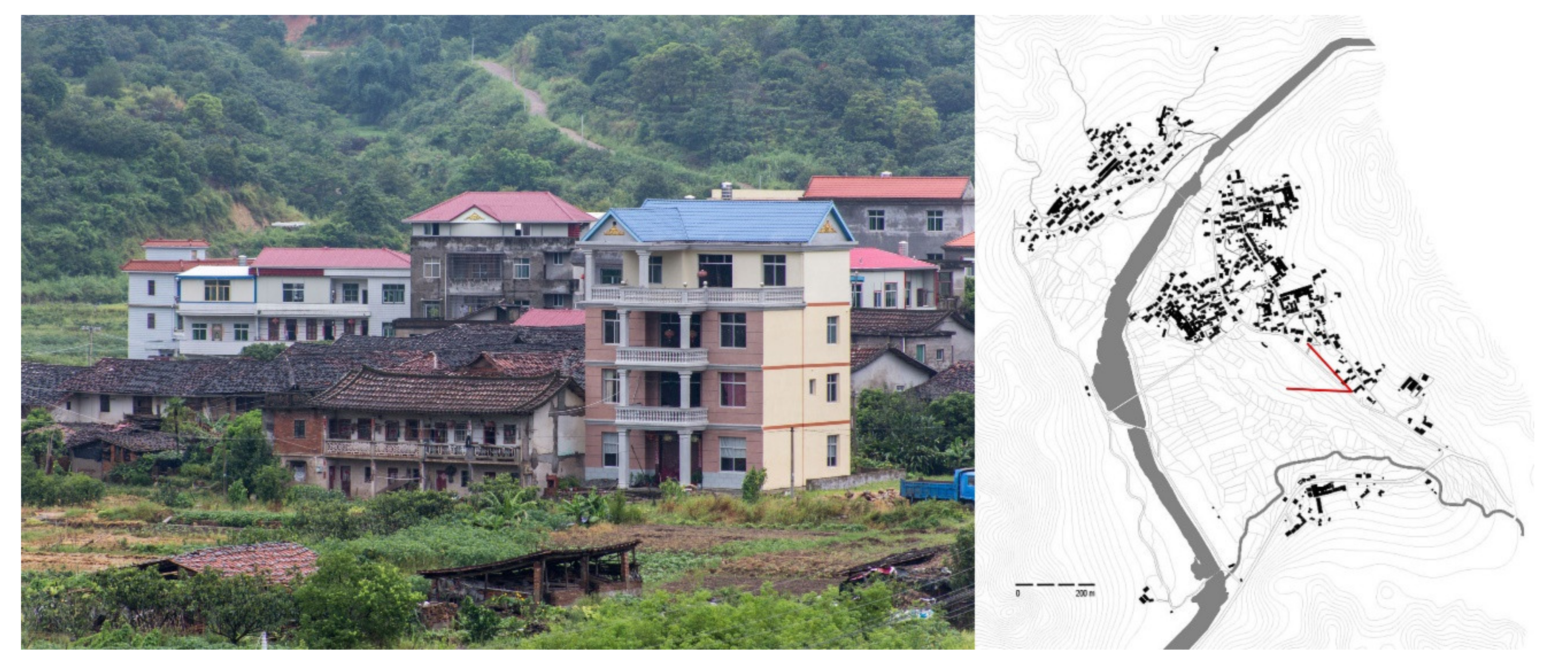
Figure 6.
Public spaces in the interior parts of the village. Photo by the author, November 2017.

Figure 7.
Diagrams interpreting the settlement’s morphology, the open space’s use, and the space of relation. Elaboration by the author, June 2020. Bottom: Two pictures showing different relationships between public space and landscape. Picture by the author, November 2017.
Figure 7.
Diagrams interpreting the settlement’s morphology, the open space’s use, and the space of relation. Elaboration by the author, June 2020. Bottom: Two pictures showing different relationships between public space and landscape. Picture by the author, November 2017.

Figure 8.
Problematic formal and material juxtapositions. Picture by the author, November 2017.

Figure 9.
Sample page two out of 292 buildings of the dwellings’ condition catalog. (Top): Houses were marked with an identification code and assessed through eight parameters. (Middle): Houses were localized in relation to their surroundings. (Bottom): Pictures served.
Figure 9.
Sample page two out of 292 buildings of the dwellings’ condition catalog. (Top): Houses were marked with an identification code and assessed through eight parameters. (Middle): Houses were localized in relation to their surroundings. (Bottom): Pictures served.

Figure 10.
Thematic mappings were produced to study the dwellings’ condition and use level in relation to their spatial distribution. Left: Dwellings’ physical condition; right: dwellings’ use level.
Figure 10.
Thematic mappings were produced to study the dwellings’ condition and use level in relation to their spatial distribution. Left: Dwellings’ physical condition; right: dwellings’ use level.

Figure 11.
(Left): Synthesis of the status quo. (Right): Design strategy on a portion of the built fabric. Elaboration by the author, June 2020.
Figure 11.
(Left): Synthesis of the status quo. (Right): Design strategy on a portion of the built fabric. Elaboration by the author, June 2020.

Figure 12.
Design tactics on single buildings. Elaboration by the author, June 2020.

Figure 13.
Left: Roof plan; right: ground level plan. Elaboration by the author, June 2020.

Figure 14.
(Left): Sections showing the status quo and the design status. (Right): Design simulations. Elaboration by the author, June 2020.
Figure 14.
(Left): Sections showing the status quo and the design status. (Right): Design simulations. Elaboration by the author, June 2020.

Figure 15.
The public space system before and after the design. Elaboration by the author, June 2020.
Figure 15.
The public space system before and after the design. Elaboration by the author, June 2020.


Table 1.
Dwellings’ condition and use level framed per number of buildings and amount of volume.
| Condition | ||||
|---|---|---|---|---|
| Decay | N. of Blds | % | m3 | % |
| Ruin | 3 | 1.03 | 508 | 0.56 |
| Heavily damaged | 24 | 8.22 | 4537 | 5.01 |
| Partly damaged | 39 | 13.36 | 10,250 | 11.32 |
| Good condition | 152 | 52.05 | 48,598 | 53.65 |
| New building | 74 | 25.34 | 26,690 | 29.46 |
| 292 | 100 | 90,583 | 100 | |
| Use Level | ||||
| Level | N. of Blds | % | m3 | % |
| Abandoned | 29 | 9.93 | 7037 | 7.77 |
| Partly abandoned | 13 | 4.45 | 2524 | 2.48 |
| Working | 250 | 85.62 | 81,022 | 89.45 |
| 292 | 100 | 90,583 | 100 | |
Table 2.
Synthesis of buildings’ status quo (use level and state of decay). Each cell reports the number of buildings, the amount of surface, and the percentage. The intensity of gray suggests a time hierarchy, with black meaning very urgent and white meaning less urgent. Elaboration by the author, May 2020.
| State of Decay | ||||||
|---|---|---|---|---|---|---|
| Ruin | Heavily Damaged | Partly Damaged | Little Mantainance | Good Condition | ||
| Use level | Abandoned | 3 348 m3 (0.38%) | 15 3330 m3 (3.68%) | 9 2115 m3 (2.33%) | 2 857 m3 (0.95%) | - |
| Underused | - | - | 5 1132 m3 (1.25%) | 5 958 m3 (1.06%) | - | |
| Working | - | 7 1337 m3 (1.48%) | 26 6843 m3 (7.55%) | 142 46,783 m3 (51.65%) | 78 26,690 m3 (29.46%) | |
Publisher’s Note: MDPI stays neutral with regard to jurisdictional claims in published maps and institutional affiliations. |
© 2022 by the author. Licensee MDPI, Basel, Switzerland. This article is an open access article distributed under the terms and conditions of the Creative Commons Attribution (CC BY) license (https://creativecommons.org/licenses/by/4.0/).
Share and Cite
MDPI and ACS Style
Semprebon, G. Design Driven Research for Countryside Revitalization of a Rural Settlement of the Fujian Province, China. Architecture 2022, 2, 255-276. https://doi.org/10.3390/architecture2020015
AMA Style
Semprebon G. Design Driven Research for Countryside Revitalization of a Rural Settlement of the Fujian Province, China. Architecture. 2022; 2(2):255-276. https://doi.org/10.3390/architecture2020015
Chicago/Turabian StyleSemprebon, Gerardo. 2022. "Design Driven Research for Countryside Revitalization of a Rural Settlement of the Fujian Province, China" Architecture 2, no. 2: 255-276. https://doi.org/10.3390/architecture2020015