
Geomorphological Evolution of the Andaman Sea Offshore Phang Nga Province (Thailand) during the Holocene: An Example for a Sediment Starving Shelf


Abstract
:1. Introduction
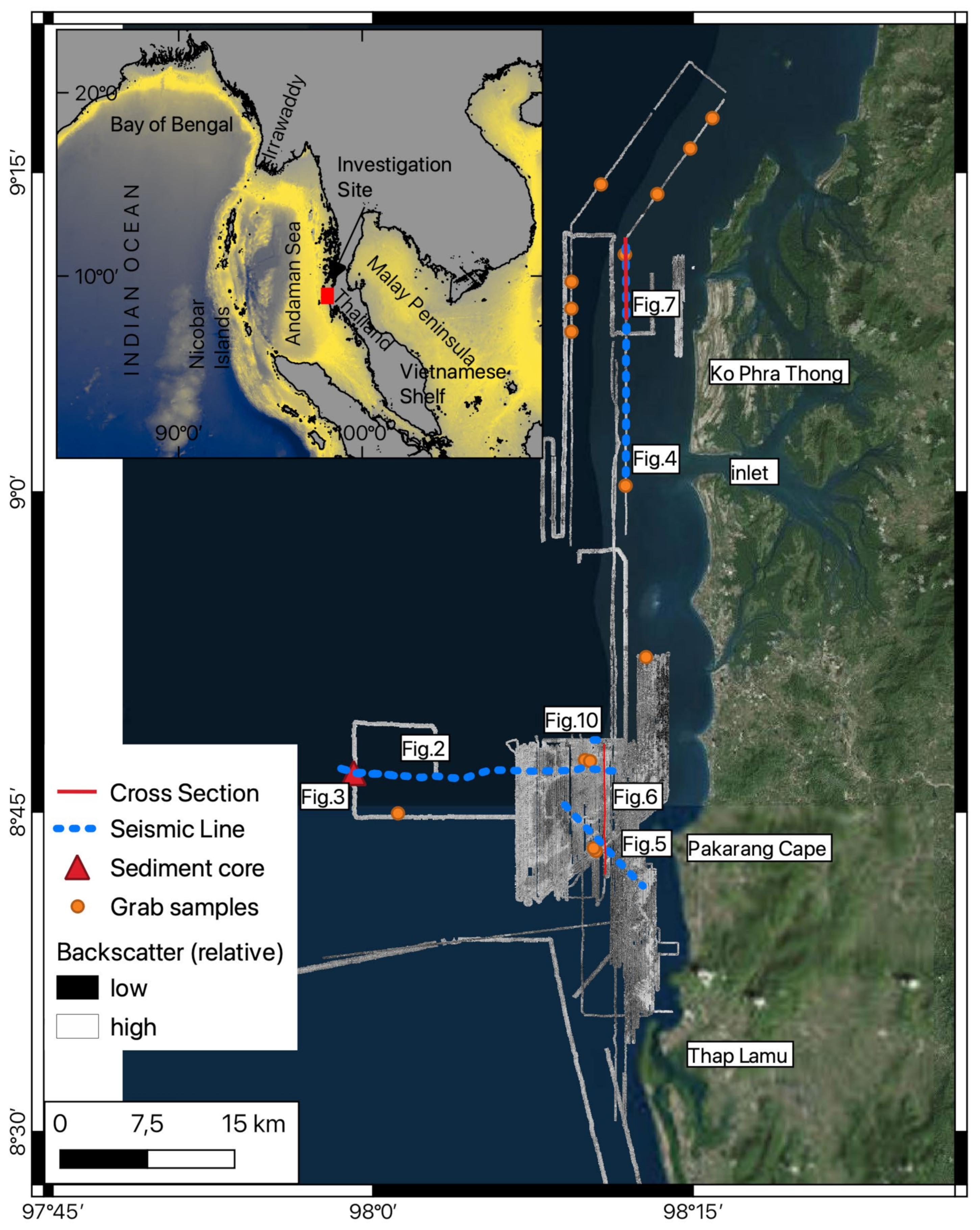
2. Regional Setting and Methods
2.1. Regional Setting
2.2. Methods
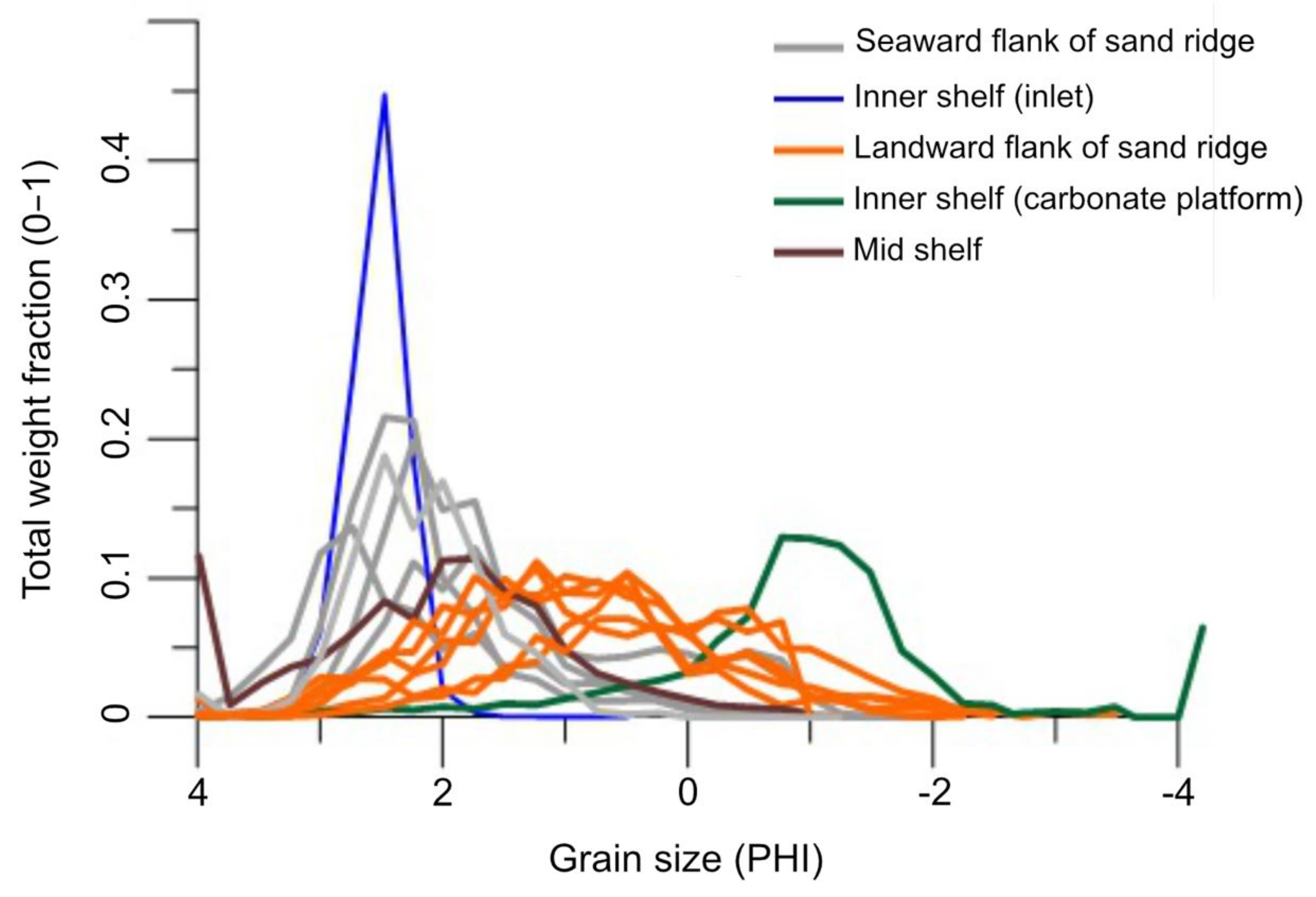
3. Results
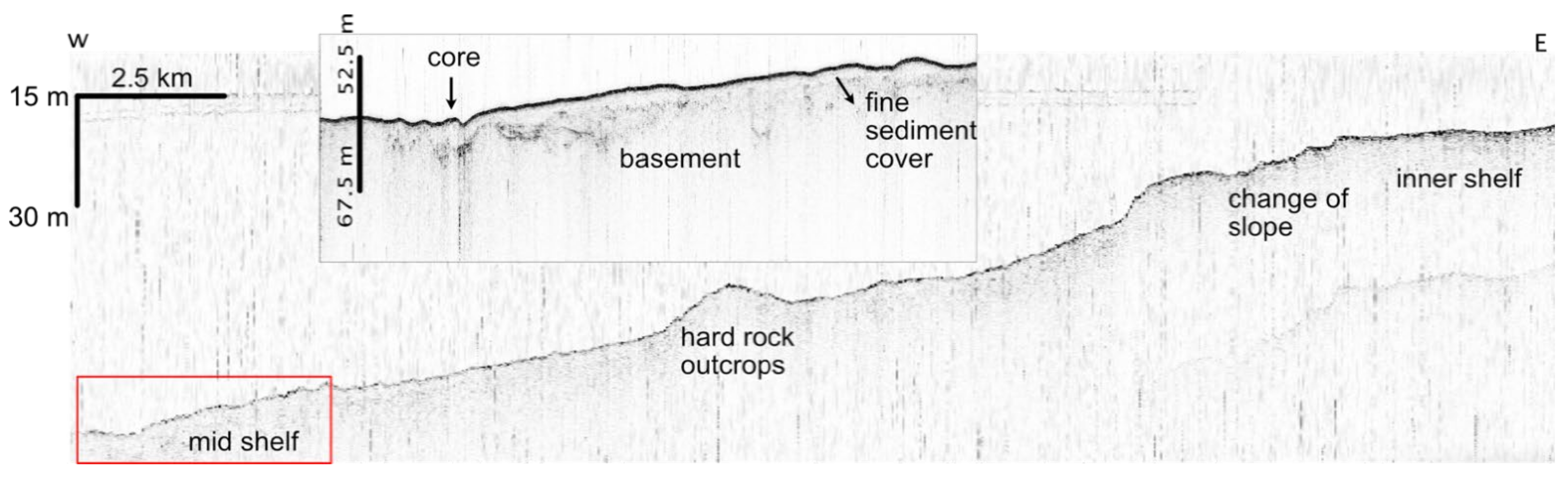
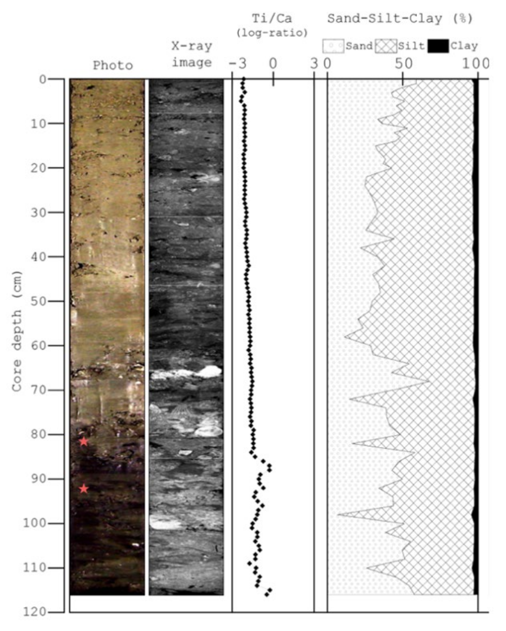
3.1. Mid Shelf
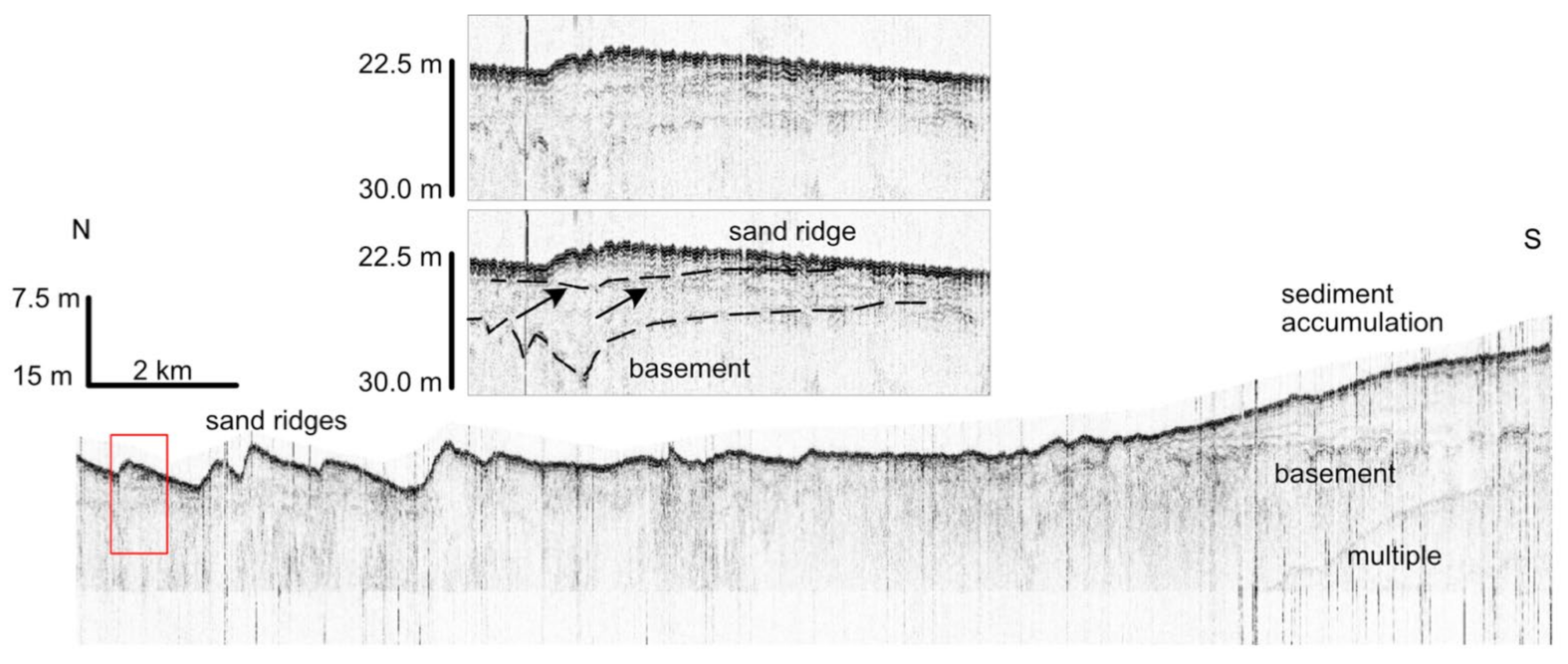
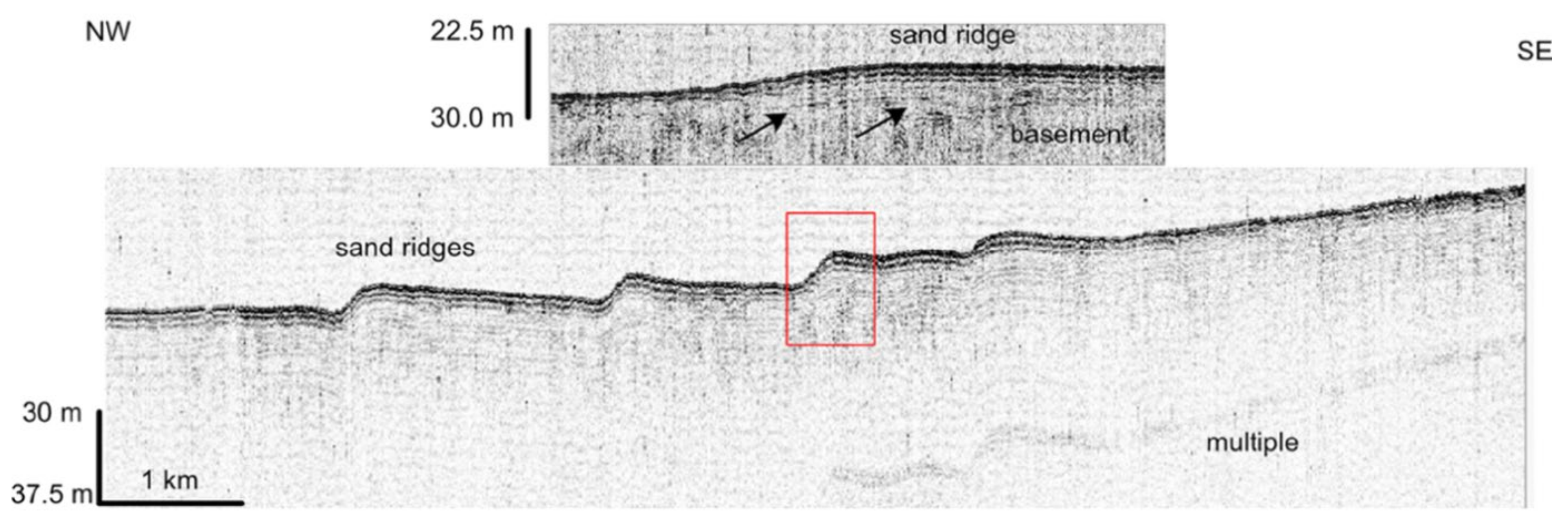
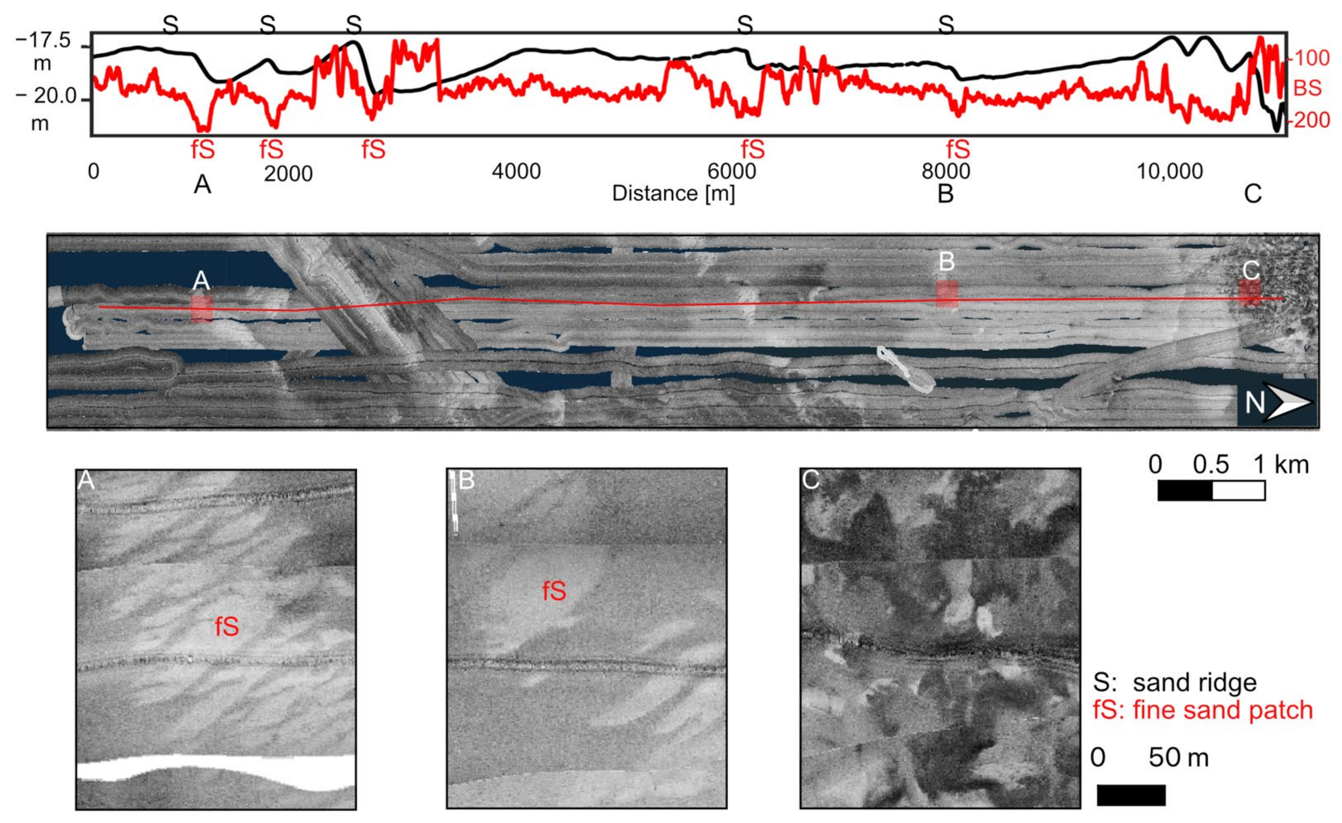
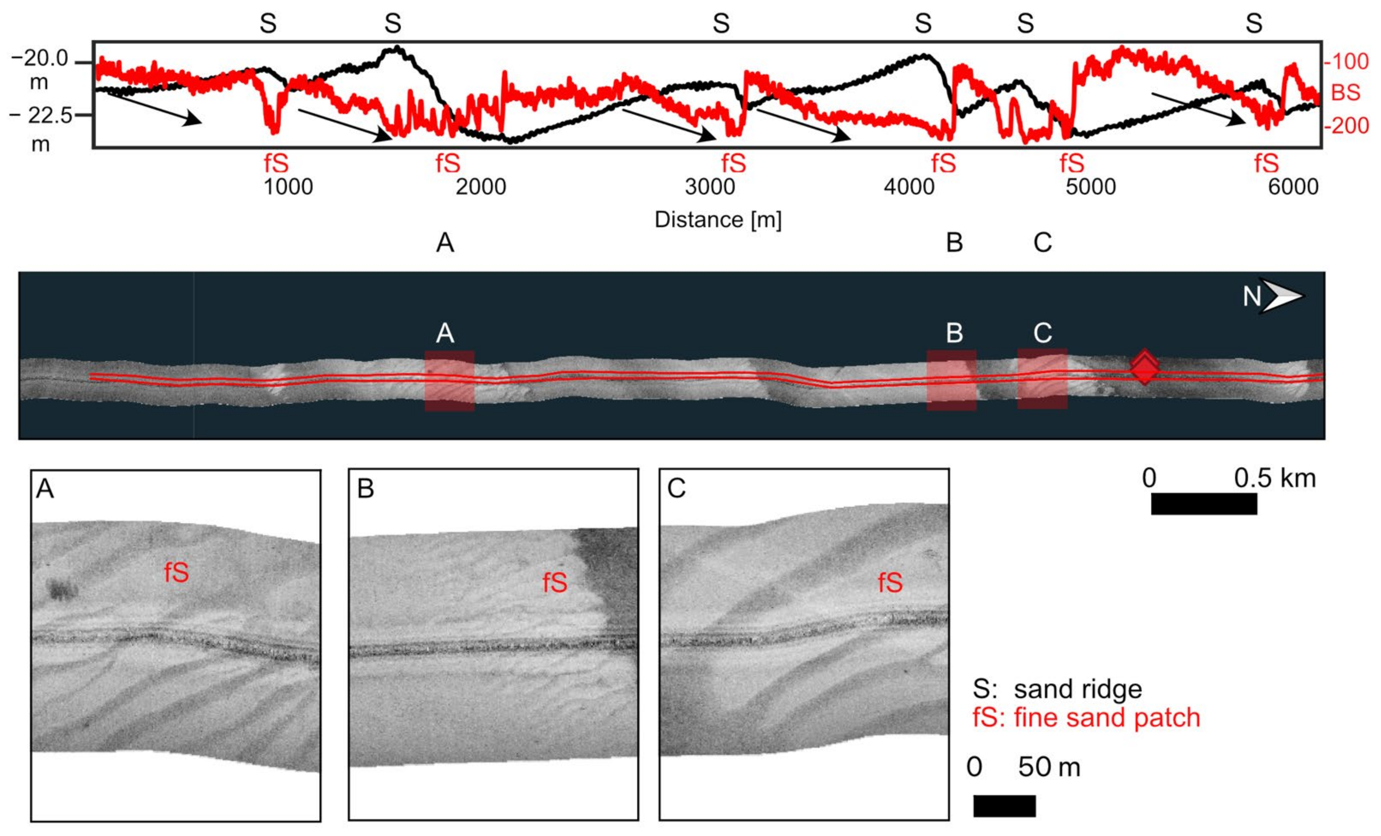
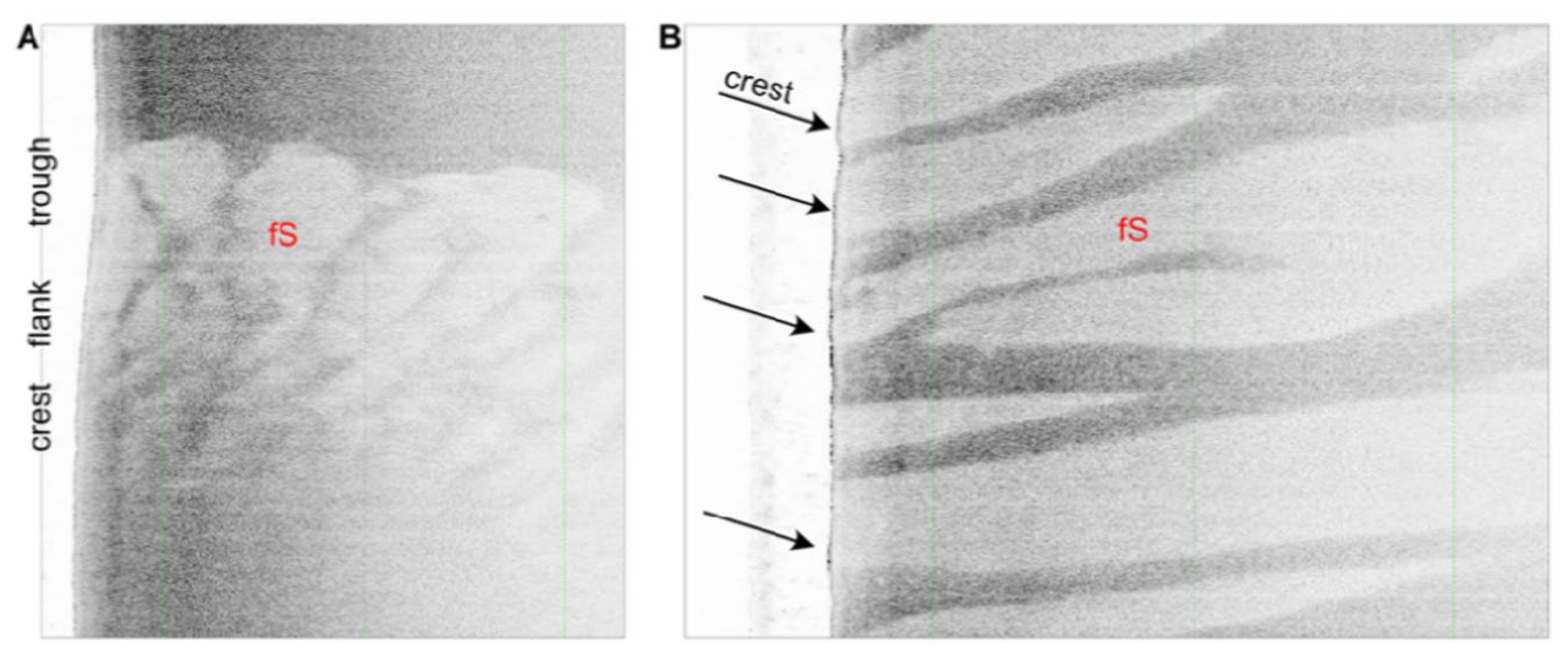
3.2. Inner Shelf: Sand Ridges and Associated Morphological Features
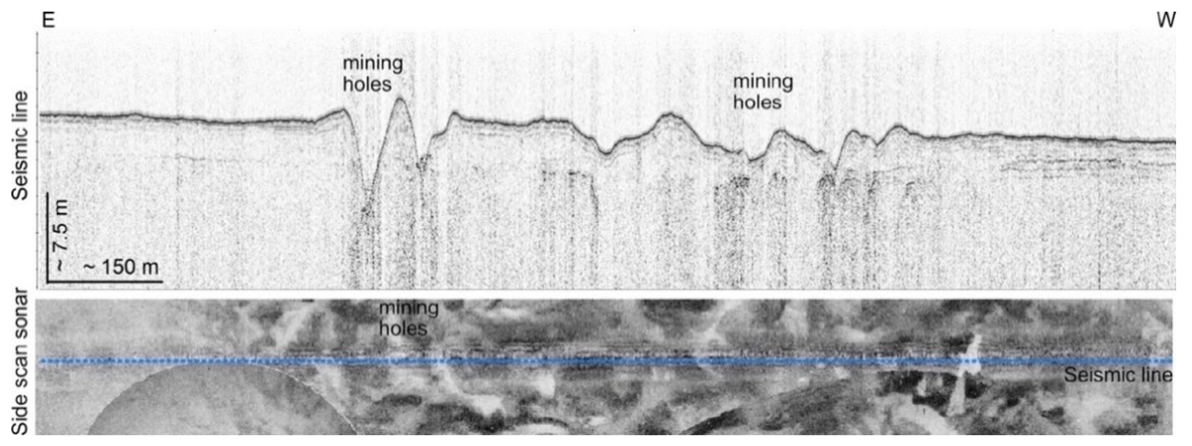
3.3. Remnants of Tin Mining Activities
4. Discussion
4.1. Holocene Sea Level Rise
4.2. Bedforms on the Inner Shelf
5. Conclusions
Author Contributions
Funding
Institutional Review Board Statement
Informed Consent Statement
Data Availability Statement
Acknowledgments
Conflicts of Interest
References
- Chiocci, F.L.; Chivas, A. An overview of the continental shelves of the world. Geol. Soc. Lond. Mem. 2014, 41, 1–5. [Google Scholar] [CrossRef] [Green Version]
- Green, M.O.; Coco, G. Review of wave-driven sediment resuspension and transport in estuaries. Rev. Geophys. 2014, 52, 77–117. [Google Scholar] [CrossRef]
- Schwarzer, K.; Diesing, M.; Larson, M.; Niedermeyer, R.-O.; Schumacher, W.; Furmanczyk, K. Coastline evolution at different time scales—Examples from the Pomeranian Bight, southern Baltic Sea. Mar. Geol. 2003, 194, 79–101. [Google Scholar] [CrossRef]
- Einsele, G. Sedimentary basins. In Evolution, Facies, and Sediment Budget; Springer: Berlin, Germany, 2001. [Google Scholar]
- Swift, D.J.P.; Thorne, J.A. Sedimentation on continental margins, I: A general model for shelf sedimentation. In Shelf Sand and Sandstone Bodies; Swift, D.J.P., Oertel, G.F., Tillman, R.W., Thorne, J.A., Eds.; Blackwell Scientific Publications: Oxford, UK; London, UK; Edinburgh, UK; Cambridge, MA, USA; Carlton, Australia, 1992; pp. 1–31. [Google Scholar] [CrossRef]
- Emery, K.O.; Uchupi, E. Western North Atlantic Ocean. Memoir 17, American Association of Petroleum Geologist, Tulsa, Oklahoma. 532 pp., 330 figs. Price U.S. $30.00. Geol. Mag. 1974, 111, 189. [Google Scholar] [CrossRef]
- Milliman, J.D.; Syvitski, J.P.M. Geomorphic/Tectonic Control of Sediment Discharge to the Ocean: The Importance of Small Mountainous Rivers. J. Geol. 1992, 100, 525–544. [Google Scholar] [CrossRef]
- Diesing, M.; Kubicki, A.; Winter, C.; Schwarzer, K. Decadal scale stability of sorted bedforms, German Bight, southeastern North Sea. Cont. Shelf Res. 2006, 26, 902–916. [Google Scholar] [CrossRef]
- Hanebuth, T.; Stattegger, K.; Grootes, P.M. Rapid Flooding of the Sunda Shelf: A Late-Glacial Sea-Level Record. Science 2000, 288, 1033–1035. [Google Scholar] [CrossRef]
- Peltier, W.R.; Fairbanks, R.G. Global glacial ice volume and Last Glacial Maximum duration from an extended Barbados sea level record. Quat. Sci. Rev. 2006, 25, 3322–3337. [Google Scholar] [CrossRef]
- Streif, H. Sedimentary record of Pleistocene and Holocene marine inundations along the North Sea coast of Lower Saxony, Germany. Quat. Int. 2004, 112, 3–28. [Google Scholar] [CrossRef]
- Dangendorf, S.; Hay, C.; Calafat, F.M.; Marcos, M.; Piecuch, C.G.; Berk, K.; Jensen, J. Persistent acceleration in global sea-level rise since the 1960s. Nat. Clim. Chang. 2019, 9, 705–710. [Google Scholar] [CrossRef] [Green Version]
- Vital, H.; Stattegger, K.; Amaro, V.E.; Schwarzer, K.; Frazão, E.P.; Tabosa, W.F.; Silveira, I.M. A modern high-energy si-liciclastic-carbonate platform: Continental shelf adjacent to northern Rio Grande do Norte State, northeastern Brazil. J. Sediment. Res. 2008, 90, 175–188. [Google Scholar]
- Schwarzer, K. Geophysical prospection and sedimentological characteristics of subaquatic tsunami deposits. In Geological Records of Tsunamis and Other Extreme Waves; Engel, M., Pilarczyk, J., May, S.M., Brill, D., Garret, E., Eds.; Elsevier: Amsterdam, The Netherlands, 2020; pp. 115–142. [Google Scholar]
- Feldens, P.; Diesing, M.; Schwarzer, K.; Heinrich, C.; Schlenz, B. Occurrence of flow parallel and flow transverse bedforms in Fehmarn Belt (SW Baltic Sea) related to the local palaeomorphology. Geomorphology 2015, 231, 53–62. [Google Scholar] [CrossRef]
- Kleinhans, M.G.; Wilbers, A.W.E.; De Swaaf, A.; Van Den Berg, J.H. Sediment Supply-Limited Bedforms in Sand-Gravel Bed Rivers. J. Sediment. Res. 2002, 72, 629–640. [Google Scholar] [CrossRef]
- Kamesh Raju, K.A.; Ramprasad, T.; Rao, P.S.; Ramalingeswara Rao, B.; Varghese, J. New insights into the tectonic evolution of the Andaman basin, northeast Indian Ocean. Earth Planet. Sci. Lett. 2004, 221, 145–162. [Google Scholar] [CrossRef]
- Liu, J.P.; Kuehl, S.A.; Pierce, A.C.; Williams, J.; Blair, N.E.; Harris, C.; Aung, D.W.; Aye, Y.Y. Fate of Ayeyarwady and Thanlwin Rivers Sediments in the Andaman Sea and Bay of Bengal. Mar. Geol. 2020, 423, 106137. [Google Scholar] [CrossRef]
- Ramaswamy, V.; Rao, P.S.; Rao, K.H.; Thwin, S.; Rao, N.S.; Raiker, V. Tidal influence on suspended sediment distribution and dispersal in the northern Andaman Sea and Gulf of Martaban. Mar. Geol. 2004, 208, 33–42. [Google Scholar] [CrossRef]
- Rao, P.S.; Ramaswamy, V.; Thwin, S. Sediment texture, distribution and transport on the Ayeyarwady continental shelf, Andaman Sea. Mar. Geol. 2005, 216, 239–247. [Google Scholar] [CrossRef]
- Usiriprisan, C.; Chiemchindaratana, S.; Shoosuwan, Y.S. Chatrapakpong. Offshore Exploration for Tin and Heavy Minerals in the Andaman Sea; Department of Mineral Resources: Bangkok, Thailand; UNDP: New York, NY, USA, 1987; p. 224. [Google Scholar]
- Bunopas, S.; Piyasin, S.; Nutasari, N. Toraniwitayapratetthai (Geology of Thailand); Department of Mineral Resources: Bangkok, Thailand, 2001. (In Thai) [Google Scholar]
- Geronimo, I.D.; Choowong, M.; Phantuwongraj, S. Geomorphology and Superficial Bottom Sediments of Khao Lak Coastal Area (SW Thailand). Pol. J. Environ. Stud. 2009, 18, 111–121. [Google Scholar]
- Schwab, J.M.; Krastel, S.; Grun, M.; Gross, F.; Pananont, P.; Jintasaeranee, P.; Bunsomboonsakul, S.; Weinrebe, W.; Winkelmann, D. Submarine mass wasting and associated tsunami risk offshore western Thailand, Andaman Sea, Indian Ocean. Nat. Hazards Earth Syst. Sci. 2012, 12, 2609–2630. [Google Scholar] [CrossRef] [Green Version]
- Dheeradilok, P. Quaternary coastal morphology and deposition in Thailand. Quat. Int. 1995, 26, 49–54. [Google Scholar] [CrossRef]
- Murty, T.S.; Flather, R.A. Impact of storm surges in the Bay of Bengal. J. Coast. Res. 1994, 12, 149–161. [Google Scholar]
- Sakuna, D.; Szczuciński, W.; Feldens, P.; Schwarzer, K.; Khokiattiwong, S. Sedimentary deposits left by the 2004 Indian Ocean tsunami on the inner continental shelf offshore of Khao Lak, Andaman Sea (Thailand). Earth Planets Space 2012, 64, 931–943. [Google Scholar] [CrossRef] [Green Version]
- Thampanya, U.; Vermaat, J.; Sinsakul, S.; Panapitukkul, N. Coastal erosion and mangrove progradation of Southern Thailand. Estuar. Coast. Shelf Sci. 2006, 68, 75–85. [Google Scholar] [CrossRef]
- Brill, D.; Jankaew, K.; Neubauer, N.-P.; Kelletat, D.; Scheffers, A.; Vött, A.; Brückner, H. Holocene coastal evolution of southwest Thailand—Implications for the site-specific preservation of palaeotsunami deposits. Z. Geomorphol. 2014, 58, 273–303. [Google Scholar] [CrossRef]
- Feldens, P.; Schwarzer, K.; Sakuna, D.; Szczuciński, W.; Sompongchaiyakul, P. Sediment distribution on the inner continental shelf off Khao Lak (Thailand) after the 2004 Indian Ocean tsunami. Earth Planets Space 2012, 64, 875–887. [Google Scholar] [CrossRef] [Green Version]
- Pongpiachan, S.; Tipmanee, D.; Deelaman, W.; Muprasit, J.; Feldens, P.; Schwarzer, K. Risk assessment of the presence of polycyclic aromatic hydrocarbons (PAHs) in coastal areas of Thailand affected by the 2004 tsunami. Mar. Pollut. Bull. 2013, 76, 370–378. [Google Scholar] [CrossRef]
- Tipmanee, D.; Deelaman, W.; Pongpiachan, S.; Schwarzer, K.; Sompongchaiyakul, P. Using Polycyclic Aromatic Hydrocarbons (PAHs) as a chemical proxy to indicate Tsunami 2004 backwash in Khao Lak coastal area, Thailand. Nat. Hazards Earth Syst. Sci. 2012, 12, 1441–1451. [Google Scholar] [CrossRef]
- Milker, Y.; Wilken, M.; Schumann, J.; Sakuna, D.; Feldens, P.; Schwarzer, K.; Schmiedl, G. Sediment transport on the inner shelf off Khao Lak (Andaman Sea, Thailand) during the 2004 Indian Ocean tsunami and former storm events: Evidence from foraminiferal transfer functions. Nat. Hazards Earth Syst. Sci. 2013, 13, 3113–3128. [Google Scholar] [CrossRef] [Green Version]
- Phantuwongraj, S.; Choowong, M. Tsunamis versus storm deposits from Thailand. Nat. Hazards 2012, 63, 31–50. [Google Scholar] [CrossRef]
- Sakuna-Schwartz, D.; Feldens, P.; Schwarzer, K.; Khokiattiwong, S.; Stattegger, K. Internal structure of event layers preserved on the Andaman Sea continental shelf, Thailand: Tsunami vs. storm and flash-flood deposits. Nat. Hazards Earth Syst. Sci. 2015, 15, 1181–1199. [Google Scholar] [CrossRef] [Green Version]
- Feldens, P.; Sakuna, D.; Schwarzer, K.; Somgpongchaiyakul, P. Shallow water sediment structures in a tsunami-affected area (Pakarang Cape, Thailand). Coastline Rep. 2010, 16, 15–25. [Google Scholar]
- Caress, D.W.; Chayes, D.N. Improved processing of Hydrosweep DS multibeam data on the R/V Maurice Ewing. Mar. Geophys. Res. 1996, 18, 631–650. [Google Scholar] [CrossRef]
- Tjallingii, R.; Stattegger, K.; Wetzel, A.; Van Phach, P. Infilling and flooding of the Mekong River incised valley during deglacial sea-level rise. Quat. Sci. Rev. 2010, 29, 1432–1444. [Google Scholar] [CrossRef]
- Sakuna-Schwartz, D. Sedimentation characteristics on the Andaman shelf, Thailand: Unraveling extreme events. Inst. Geosci. Kiel. 2013, 83, 1–68. [Google Scholar]
- Reimer, P.J. Intcal04: Terestrial radiocarbon age calibration, 0–26 cal kyr BP. Radiocarbon 2004, 46, 1029–1058. [Google Scholar]
- Calvert, S.E.; Pedersen, T.F. Chapter Fourteen Elemental Proxies for Palaeoclimatic and Palaeoceanographic Variability in Marine Sediments: Interpretation and Application. Dev. Mar. Geol. 2007, 1, 567–644. [Google Scholar]
- Schimanski, A.; Stattegger, K. Deglacial and Holocene evolution of the Vietnam shelf: Stratigraphy, sediments and sea-level change. Mar. Geol. 2005, 214, 365–387. [Google Scholar] [CrossRef]
- Tjallingii, R.; Stattegger, K.; Stocchi, P.; Saito, Y.; Wetzel, A. Rapid flooding of the southern Vietnam shelf during the early to mid-Holocene. J. Quat. Sci. 2014, 29, 581–588. [Google Scholar] [CrossRef]
- Gao, S.; Collins, M.B. Holocene sedimentary systems on continental shelves. Mar. Geol. 2014, 352, 268–294. [Google Scholar] [CrossRef]
- Michaelis, R.; Hass, H.C.; Mielck, F.; Papenmeier, S.; Sander, L.; Ebbe, B.; Gutow, L.; Wiltshire, K.H. Hard-substrate habitats in the German Bight (South-Eastern North Sea) observed using drift videos. J. Sea Res. 2019, 144, 78–84. [Google Scholar] [CrossRef]
- Diesing, M.; Schwarzer, K. Identification of submarine hard-bottom substrates in the German North Sea and Baltic Sea EEZ with high-resolution acoustic seafloor imaging. In Progress in Marine Conservation in Europe; Springer Science and Business Media LLC: Berlin/Heidelberg, Germany, 2006; pp. 111–125. [Google Scholar]
- Zeiler, M.; Schulz-Ohlberg, J.; Figge, K. Mobile sand deposits and shoreface sediment dynamics in the inner German Bight (North Sea). Mar. Geol. 2000, 170, 363–380. [Google Scholar] [CrossRef]
- Diesing, M.; Schwarzer, K.; Zeiler, M.; Klein, H. Comparison of marine sediment extraction sites by means of shoreface zona-tion. J. Coast. Res. 2006, SI39, 783–788. [Google Scholar]
- Van de Meene, J.W.H.; van Rijn, L.C. The shoreface-connected ridges along the central Dutch coast—Part 2: Morphological modelling. Cont. Shelf Res. 2000, 20, 2325–2345. [Google Scholar] [CrossRef]
- Holland, K.T.; Elmore, P.A. A review of heterogeneous sediments in coastal environments. Earth-Sci. Rev. 2008, 89, 116–134. [Google Scholar] [CrossRef]
- Snedden, J.W.; Dalrymple, R.W. Modern shelf sand ridges: From historical perspective to a unified hydrodynamic and evo-lutionary model. Quat. Int. 1999, 112, 3–28. [Google Scholar]
- Swift, D.J.P.; Field, M.E. Evolution of a classic sand ridge field: Maryland sector, North American inner shelf. Sedimentology 1981, 28, 461–482. [Google Scholar] [CrossRef]
- Goff, J.A.; Swift, D.J.P.; Duncan, C.S.; Mayer, L.A.; Hughes-Clarke, J. High-resolution swath sonar investigation of sand ridge, dune and ribbon morphology in the offshore environment of the New Jersey margin. Mar. Geol. 1999, 161, 307–337. [Google Scholar] [CrossRef]
- Goff, J.A.; Olson, H.C.; Duncan, C.S. Correlation of side-scan backscatter intensity with grain-size distribution of shelf sediments, New Jersey margin. Geo-Mar. Lett. 2000, 20, 43–49. [Google Scholar] [CrossRef]
- Kenyon, N.H.; Belderson, R.H.; Stride, A.H.; Johnson, M.A. Offshore tidal sand-banks as indicators of net sand transport and as potential deposits. In Holocene Marine Sedimentation in the North Sea Basin; Wiley: Hoboken, NJ, USA, 1981; pp. 257–268. [Google Scholar]
- Van de Meene, J.W.H.; van Rijn, L.C. The shoreface-connected ridges along the central Dutch coast—Part 1: Field observations. Cont. Shelf Res. 2000, 20, 2295–2323. [Google Scholar] [CrossRef]
- Dyer, K.R.; Huntley, D.A. The origin, classification and modelling of sand banks and ridges. Cont. Shelf Res. 1999, 19, 1285–1330. [Google Scholar] [CrossRef]
- Belderson, R.H. Offshore tidal and non-tidal sand ridges and sheets: Differences in morphology and hydrodynamic setting. Holocene Mar. Sediment. North Sea Basin 1986, 5, 257–268. [Google Scholar]
- Amos, C.L.; King, E.L. Bedforms of the Canadian eastern seaboard: A comparison with global occurrences. Mar. Geol. 1984, 57, 167–208. [Google Scholar] [CrossRef]
- Pendleton, E.A.; Brothers, L.L.; Thieler, E.R.; Sweeney, E.M. Sand ridge morphology and bedform migration patterns derived from bathymetry and backscatter on the inner-continental shelf offshore of Assateague Island, USA. Cont. Shelf Res. 2017, 144, 80–97. [Google Scholar] [CrossRef]
- Swift, D.J.P.; Parker, G.; Lanfredi, N.W.; Perillo, G.; Figge, K. Shoreface-connected sand ridges on American and European shelves: A comparison. Estuar. Coast. Mar. Sci. 1978, 7, 257–273. [Google Scholar] [CrossRef]
- Scheffers, A.; Brill, D.; Kelletat, D.; Brückner, H.; Scheffers, S.; Fox, K. Holocene sea levels along the Andaman Sea coast of Thailand. Holocene 2012, 22, 1169–1180. [Google Scholar] [CrossRef]
- Durán, R.; Guillén, J.; Rivera, J.; Muñoz, A.; Lobo, F.J.; Fernández-Salas, L.M.; Acosta, J. Subaqueous dunes over sand ridges on the Murcia outer shelf. In Atlas of Bedforms in the Western Mediterranean; Springer: Singapore, 2017; pp. 187–192. [Google Scholar]
- Flemming, B.W. Zur klassifikation subaquatischer, strömungstransversaler Transportkörper. Boch. Geol. Und Geotech. Arb. 1988, 29, 44–47. [Google Scholar]
- Tuijnder, A.P.; Ribberink, J.S.; Hulscher, S.J.M.H. An experimental study into the geometry of supply-limited dunes. Sedimentology 2009, 56, 1713–1727. [Google Scholar] [CrossRef] [Green Version]
- Harris, P.T. Reversal of subtidal dune asymmetries caused by seasonally reversing wind-driven currents in Torres Strait, northeastern Australia. Cont. Shelf Res. 1991, 11, 655–662. [Google Scholar] [CrossRef]
- Harris, P.T. Sandwave movement under tidal and wind-driven currents in a shallow marine environment: Adolphus Channel, northeastern Australia. Cont. Shelf Res. 1989, 9, 981–1002. [Google Scholar] [CrossRef]


| Laboratory Nr. * | Depth [cm] | Material | δ13C (‰) | 14C Age yr BP | Cal Age yr BP: (2 Sigma) |
|---|---|---|---|---|---|
| KIA45569 | 82 | wood | −24.60 ± 0.19 | 11,439 ± 53 | 13,427–13,178 |
| KIA45568 | 82 | wood | −25.85 ± 0.15 | 11,013 ± 47 | 13,080–12,725 |
| KIA45570 | 92 | wood | −28.64 ± 0.20 | 11,141± 61 | 13,202–12,799 |
Publisher’s Note: MDPI stays neutral with regard to jurisdictional claims in published maps and institutional affiliations. |
© 2022 by the authors. Licensee MDPI, Basel, Switzerland. This article is an open access article distributed under the terms and conditions of the Creative Commons Attribution (CC BY) license (https://creativecommons.org/licenses/by/4.0/).
Share and Cite
Feldens, P.; Schwarzer, K.; Sakuna-Schwartz, D.; Khokiattiwong, S. Geomorphological Evolution of the Andaman Sea Offshore Phang Nga Province (Thailand) during the Holocene: An Example for a Sediment Starving Shelf. Coasts 2022, 2, 1-16. https://doi.org/10.3390/coasts2010001
Feldens P, Schwarzer K, Sakuna-Schwartz D, Khokiattiwong S. Geomorphological Evolution of the Andaman Sea Offshore Phang Nga Province (Thailand) during the Holocene: An Example for a Sediment Starving Shelf. Coasts. 2022; 2(1):1-16. https://doi.org/10.3390/coasts2010001
Chicago/Turabian StyleFeldens, Peter, Klaus Schwarzer, Daroonwan Sakuna-Schwartz, and Somkiat Khokiattiwong. 2022. "Geomorphological Evolution of the Andaman Sea Offshore Phang Nga Province (Thailand) during the Holocene: An Example for a Sediment Starving Shelf" Coasts 2, no. 1: 1-16. https://doi.org/10.3390/coasts2010001