

Horizontal Rates of Wetland Migration Appear Unlikely to Keep Pace with Shoreline Transgression under Conditions of 21st Century Accelerating Sea Level Rise along the Mid-Atlantic and Southeastern USA


Abstract
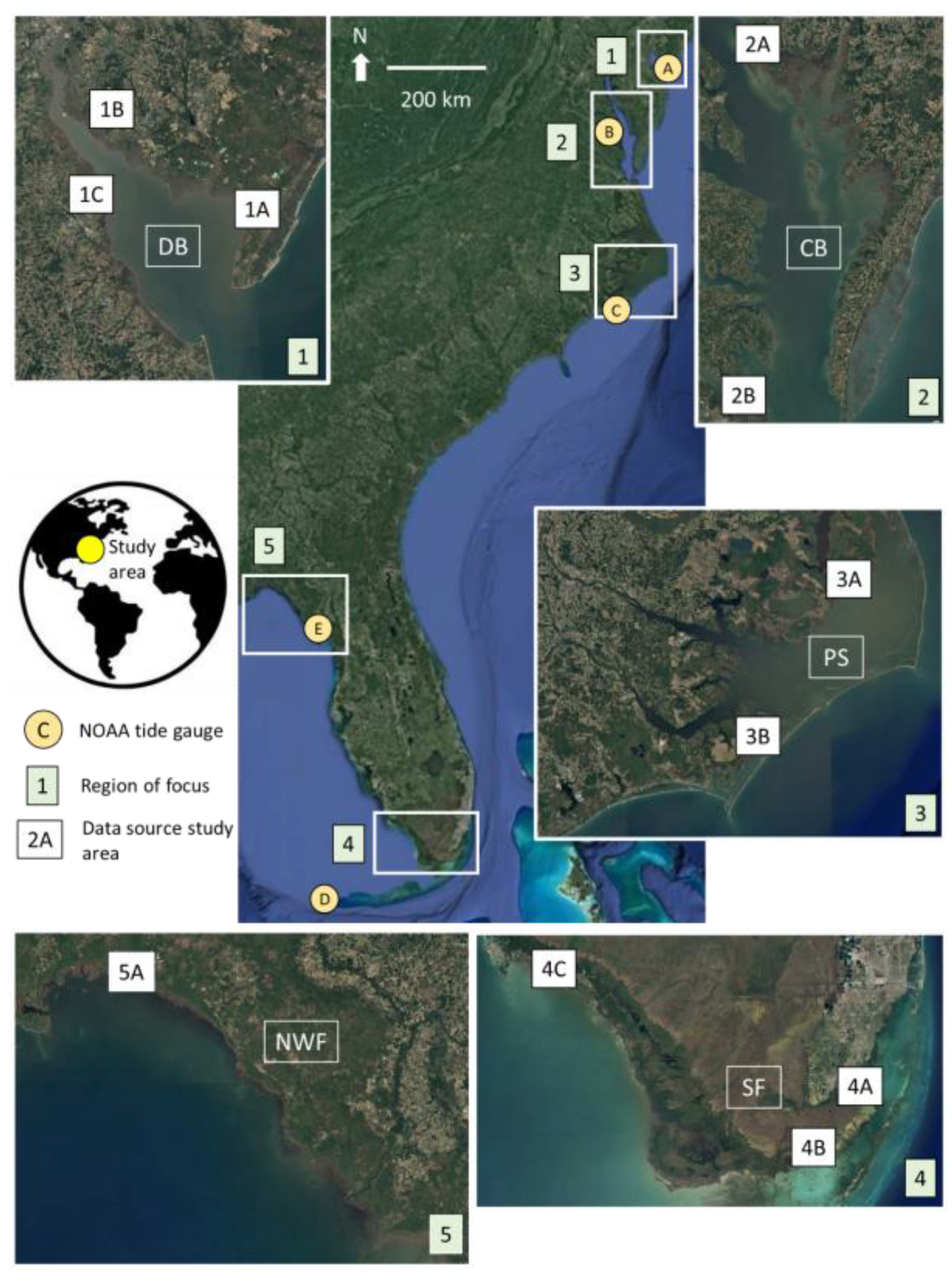
1. Introduction
2. Materials & Methods
2.1. Wetland Horizontal Migration
2.2. Shoreline Transgression
3. Results
3.1. Wetland Horizontal Migration
3.2. Shoreline Transgression
3.3. Assessing Wetland Resilience during the 21st Century
4. Discussion
5. Conclusions
Supplementary Materials
Funding
Institutional Review Board Statement
Informed Consent Statement
Data Availability Statement
Acknowledgments
Conflicts of Interest
References
- Lal, K.K.; Woodroffe, C.D.; Zawadzki, A.; Rogers, K. Coastal Wetland Elevation Dynamics, Sedimentation, and Accommodation Space Across Timescales. Estuaries Coasts 2023. [Google Scholar] [CrossRef]
- Nyman, J.A.; DeLaune, R.D. Four Potential Impacts of Global Sea Level Rise on Coastal Marsh Stability. Curr. Top. Wetl. Biogeochem. 1999, 3, 112–117. [Google Scholar]
- Craft, C.; Clough, J.; Ehman, J.; Joye, S.; Park, R.; Pennings, S.; Guo, H.; Machmuller, M. Forecasting the Effects of Accelerated Sea-Level Rise on Tidal Marsh Ecosystem Services. Front. Ecol. Environ. 2009, 7, 73–78. [Google Scholar] [CrossRef]
- Elsey-Quirk, T.; Watson, E.B.; Raper, K.; Kreeger, D.; Paudel, B.; Haaf, L.; Maxwell-Doyle, M.; Padeletti, A.; Reilly, E.; Velinsky, D.J. Relationships between Ecosystem Properties and Sea-Level Rise Vulnerability of Tidal Wetlands of the U.S. Mid-Atlantic. Env. Monit Assess 2022, 194, 292. [Google Scholar] [CrossRef] [PubMed]
- Seitz, C.; Kenney, W.F.; Patterson-Boyarski, B.; Curtis, J.H.; Vélez, M.I.; Glodzik, K.; Escobar, J.; Brenner, M. Sea-Level Changes and Paleoenvironmental Responses in a Coastal Florida Salt Marsh over the Last Three Centuries. J. Paleolimnol. 2023, 69, 327–343. [Google Scholar] [CrossRef]
- Brinson, M.M.; Christian, R.R.; Blum, L.K. Multiple States in the Sea-Level Induced Transition from Terrestrial Forest to Estuary. Estuaries 1995, 18, 648. [Google Scholar] [CrossRef]
- Williams, K.; Ewel, K.C.; Stumpf, R.P.; Putz, F.E.; Workman, T.W. Sea Level Rise and Coastal Forest Retreat on the West Coast of Florida, USA. Ecology 1999, 80, 2045–2063. [Google Scholar] [CrossRef]
- Lynch, J.C.; Meriwether, J.R.; McKee, B.A.; Vera-Herrera, F.; Twilley, R.R. Recent Accretion in Mangrove Ecosystems Based on 137Cs and 210Pb. Estuaries 1989, 12, 284–299. [Google Scholar] [CrossRef]
- Parkinson, R.W.; DeLaune, R.D.; White, J.R. Holocene Sea-Level Rise and the Fate of Mangrove Forests within the Wider Caribbean Region. J. Coast. Res. 1994, 10, 1077–1086. [Google Scholar]
- Craft, C.B. Tidal Freshwater Forest Accretion Does Not Keep Pace with Sea Level Rise. Glob. Chang. Biol. 2012, 18, 3615–3623. [Google Scholar] [CrossRef]
- Doyle, T.W.; Krauss, K.W.; Conner, W.H.; From, A.S. Predicting the Retreat and Migration of Tidal Forests along the Northern Gulf of Mexico under Sea-Level Rise. For. Ecol. Manag. 2010, 259, 770–777. [Google Scholar] [CrossRef]
- Enwright, N.M.; Griffith, K.T.; Osland, M.J. Barriers to and Opportunities for Landward Migration of Coastal Wetlands with Sea-Level Rise. Front. Ecol. Environ. 2016, 14, 307–316. [Google Scholar] [CrossRef]
- Schile, L.M.; Callaway, J.C.; Morris, J.T.; Stralberg, D.; Parker, V.T.; Kelly, M. Modeling Tidal Marsh Distribution with Sea-Level Rise: Evaluating the Role of Vegetation, Sediment, and Upland Habitat in Marsh Resiliency. PLoS ONE 2014, 9, e88760. [Google Scholar] [CrossRef]
- Breda, A.; Saco, P.M.; Sandi, S.G.; Saintilan, N.; Riccardi, G.; Rodríguez, J.F. Accretion, Retreat and Transgression of Coastal Wetlands Experiencing Sea-Level Rise. Hydrol. Earth Syst. Sci. 2021, 25, 769–786. [Google Scholar] [CrossRef]
- Mariotti, G.; Carr, J. Dual Role of Salt Marsh Retreat: Long-term Loss and Short-term Resilience. Water Resour. Res. 2014, 50, 2963–2974. [Google Scholar] [CrossRef]
- Linhoss, A.C.; Kiker, G.; Shirley, M.; Frank, K. Sea-Level Rise, Inundation, and Marsh Migration: Simulating Impacts on Developed Lands and Environmental Systems. J. Coast. Res. 2015, 31, 36. [Google Scholar] [CrossRef]
- Mcleod, E.; Poulter, B.; Hinkel, J.; Reyes, E.; Salm, R. Sea-Level Rise Impact Models and Environmental Conservation: A Review of Models and Their Applications. Ocean Coast. Manag. 2010, 53, 507–517. [Google Scholar] [CrossRef]
- Wen, L.; Glasby, T.M.; Hughes, M.G. The Race for Space: Modelling the Landward Migration of Coastal Wetlands under Sea Level Rise at Regional Scale. Sci. Total Environ. 2023, 859, 160483. [Google Scholar] [CrossRef] [PubMed]
- Enwright, N.M.; Osland, M.J.; Thorne, K.M.; Guntenspergen, G.R.; Grace, J.B.; Steyer, G.D.; Herold, N.; Chivoiu, B.; Han, M. Observing Coastal Wetland Transitions Using National Land Cover Products. Prog. Phys. Geogr. Earth Environ. 2023, 48, 113–135. [Google Scholar] [CrossRef]
- Fagherazzi, S.; Anisfeld, S.C.; Blum, L.K.; Long, E.V.; Feagin, R.A.; Fernandes, A.; Kearney, W.S.; Williams, K. Sea Level Rise and the Dynamics of the Marsh-Upland Boundary. Front. Environ. Sci. 2019, 7, 25. [Google Scholar] [CrossRef]
- Moorhead, K.K.; Brinson, M.M. Response of Wetlands to Rising Sea Level in the Lower Coastal Plain of North Carolina. Ecol. Appl. 1995, 5, 261–271. [Google Scholar] [CrossRef]
- Borchert, S.M.; Osland, M.J.; Enwright, N.M.; Griffith, K.T. Coastal Wetland Adaptation to Sea Level Rise: Quantifying Potential for Landward Migration and Coastal Squeeze. J. Appl. Ecol. 2018, 55, 2876–2887. [Google Scholar] [CrossRef]
- Geselbracht, L.; Freeman, K.; Kelly, E.; Gordon, D.R.; Putz, F.E. Retrospective and Prospective Model Simulations of Sea Level Rise Impacts on Gulf of Mexico Coastal Marshes and Forests in Waccasassa Bay, Florida. Clim. Chang. 2011, 107, 35–57. [Google Scholar] [CrossRef][Green Version]
- Kirwan, M.L.; Walters, D.C.; Reay, W.G.; Carr, J.A. Sea Level Driven Marsh Expansion in a Coupled Model of Marsh Erosion and Migration: Sea Level Driven Marsh Expansion. Geophys. Res. Lett. 2016, 43, 4366–4373. [Google Scholar] [CrossRef]
- Morris, J.T.; Drexler, J.Z.; Vaughn, L.J.S.; Robinson, A.H. An Assessment of Future Tidal Marsh Resilience in the San Francisco Estuary through Modeling and Quantifiable Metrics of Sustainability. Front. Environ. Sci. 2022, 10, 1039143. [Google Scholar] [CrossRef]
- Osland, M.J.; Chivoiu, B.; Enwright, N.M.; Thorne, K.M.; Guntenspergen, G.R.; Grace, J.B.; Dale, L.L.; Brooks, W.; Herold, N.; Day, J.W.; et al. Migration and Transformation of Coastal Wetlands in Response to Rising Seas. Sci. Adv. 2022, 8, eabo5174. [Google Scholar] [CrossRef]
- Familkhalili, R.; Davis, J.; Currin, C.A.; Heppe, M.E.; Cohen, S. Quantifying the Benefits of Wetland Restoration under Projected Sea Level Rise. Front. Mar. Sci. 2023, 10, 1187276. [Google Scholar] [CrossRef]
- Hussein, A.H. Modeling of Sea-Level Rise and Deforestation in Submerging Coastal Ultisols of Chesapeake Bay. Soil Sci. Soc. Am. J. 2007, 73, 185. [Google Scholar] [CrossRef]
- Warnell, K.; Olander, L.; Currin, C. Sea Level Rise Drives Carbon and Habitat Loss in the U.S. Mid-Atlantic Coastal Zone. PLoS Clim. 2022, 1, e0000044. [Google Scholar] [CrossRef]
- Passeri, D.L.; Hagen, S.C.; Medeiros, S.C.; Bilskie, M.V.; Alizad, K.; Wang, D. The Dynamic Effects of Sea Level Rise on Low-Gradient Coastal Landscapes: A Review. Earth’s Future 2015, 3, 159–181. [Google Scholar] [CrossRef]
- Tabak, N.M.; Laba, M.; Spector, S. Simulating the Effects of Sea Level Rise on the Resilience and Migration of Tidal Wetlands along the Hudson River. PLoS ONE 2016, 11, e0152437. [Google Scholar] [CrossRef] [PubMed]
- Holmquist, J.R.; Brown, L.N.; MacDonald, G.M. Localized Scenarios and Latitudinal Patterns of Vertical and Lateral Resilience of Tidal Marshes to Sea-Level Rise in the Contiguous United States. Earth’s Future 2021, 9, e2020EF001804. [Google Scholar] [CrossRef]
- Elsey-Quirk, T.; Mariotti, G.; Valentine, K.; Raper, K. Retreating Marsh Shoreline Creates Hotspots of High-Marsh Plant Diversity. Sci. Rep. 2019, 9, 5795. [Google Scholar] [CrossRef] [PubMed]
- Farron, S.J.; Hughes, Z.J.; FitzGerald, D.M. Assessing the Response of the Great Marsh to Sea-Level Rise: Migration, Submersion or Survival. Mar. Geol. 2020, 425, 106195. [Google Scholar] [CrossRef]
- Kirwan, M.L.; Temmerman, S.; Skeehan, E.E.; Guntenspergen, G.R.; Fagherazzi, S. Overestimation of Marsh Vulnerability to Sea Level Rise. Nat. Clim. Chang. 2016, 6, 253–260. [Google Scholar] [CrossRef]
- Sweet, W.V.; Hamlington, B.D.; Kopp, R.E.; Weaver, C.P.; Barnard, P.L.; Bekaert, D.; Brooks, W.; Craghan, M.; Dusek, G.; Frederikse, T.; et al. Global and Regional Sea Level Rise Scenarios for the United States: Updated Mean Projections and Extreme Water Level Probabilities along U.S. Coastlines; NOAA: Silver Spring, MD, USA, 2022; pp. 1–111.
- Smith, J.A.M. The Role of Phragmites Australis in Mediating Inland Salt Marsh Migration in a Mid-Atlantic Estuary. PLoS ONE 2013, 8, e65091. [Google Scholar] [CrossRef] [PubMed]
- Schieder, N.W.; Kirwan, M.L. Sea-Level Driven Acceleration in Coastal Forest Retreat. Geology 2019, 47, 1151–1155. [Google Scholar] [CrossRef]
- Chen, Y.; Kirwan, M.L. Climate-Driven Decoupling of Wetland and Upland Biomass Trends on the Mid-Atlantic Coast. Nat. Geosci. 2022, 15, 913–918. [Google Scholar] [CrossRef]
- Miller, C.B.; Rodriguez, A.B.; Bost, M.C. Sea-Level Rise, Localized Subsidence, and Increased Storminess Promote Saltmarsh Transgression across Low-Gradient Upland Areas. Quat. Sci. Rev. 2021, 265, 107000. [Google Scholar] [CrossRef]
- Gaiser, E.E.; Zafiris, A.; Ruiz, P.L.; Tobias, F.A.C.; Ross, M.S. Tracking Rates of Ecotone Migration Due to Salt-Water Encroachment Using Fossil Mollusks in Coastal South Florida. Hydrobiologia 2006, 569, 237–257. [Google Scholar] [CrossRef]
- Meeder, J.F.; Parkinson, R.W. SE Saline Everglades Transgressive Sedimentation in Response to Historic Acceleration in Sea-Level Rise: A Viable Marker for the Base of the Anthropocene? J. Coast. Res. 2018, 342, 490–497. [Google Scholar] [CrossRef]
- Ross, M.S.; Meeder, J.F.; Sah, J.P.; Ruiz, P.L.; Telesnicki, G.J. The Southeast Saline Everglades Revisited: 50 Years of Coastal Vegetation Change. J. Veg. Sci. 2000, 11, 101–112. [Google Scholar] [CrossRef]
- Krauss, K.W.; From, A.S.; Doyle, T.W.; Doyle, T.J.; Barry, M.J. Sea-Level Rise and Landscape Change Influence Mangrove Encroachment onto Marsh in the Ten Thousand Islands Region of Florida, USA. J. Coast. Conserv. 2011, 15, 629–638. [Google Scholar] [CrossRef]
- Raabe, E.A.; Stumpf, R.P. Expansion of Tidal Marsh in Response to Sea-Level Rise: Gulf Coast of Florida, USA. Estuaries Coasts 2016, 39, 145–157. [Google Scholar] [CrossRef]
- Toscano, M.A.; Macintyre, I.G. Corrected Western Atlantic Sea-Level Curve for the Last 11,000 Years Based on Calibrated 14C Dates from Acropora Palmata Framework and Intertidal Mangrove Peat. Coral Reefs 2003, 22, 257–270. [Google Scholar] [CrossRef]
- Parkinson, R.W.; Wdowinski, S. Geomorphic Response of the Georgia Bight Coastal Zone to Accelerating Sea Level Rise, Southeastern USA. Coasts 2024, 4, 1–20. [Google Scholar] [CrossRef]
- Parkinson, R.W.; Wdowinski, S. A Unified Conceptual Model of Coastal Response to Accelerating Sea Level Rise, Florida, U.S.A. Sci. Total Environ. 2023, 892, 164448. [Google Scholar] [CrossRef]
- NOAA National Ocean Service 2022 Sea Level Rise Technical Report: Data and Tools. Available online: https://oceanservice.noaa.gov/hazards/sealevelrise/sealevelrise-data.html (accessed on 11 December 2023).
- Kopp, R.E.; Horton, B.P.; Kemp, A.C.; Tebaldi, C. Past and Future Sea-Level Rise along the Coast of North Carolina, USA. Clim. Chang. 2015, 132, 693–707. [Google Scholar] [CrossRef]
- Hawkes, A.D.; Kemp, A.C.; Donnelly, J.P.; Horton, B.P.; Peltier, W.R.; Cahill, N.; Hill, D.F.; Ashe, E.; Alexander, C.R. Relative Sea-Level Change in Northeastern Florida (USA) during the Last ∼8.0 Ka. Quat. Sci. Rev. 2016, 142, 90–101. [Google Scholar] [CrossRef]
- Boyd, B.M.; Sommerfield, C.K. Marsh Accretion and Sediment Accumulation in a Managed Tidal Wetland Complex of Delaware Bay. Ecol. Eng. 2016, 92, 37–46. [Google Scholar] [CrossRef]
- Corbett, D.R.; Vance, D.; Letrick, E.; Mallinson, D.; Culver, S. Decadal-Scale Sediment Dynamics and Environmental Change in the Albemarle Estuarine System, North Carolina. Estuar. Coast. Shelf Sci. 2007, 71, 717–729. [Google Scholar] [CrossRef]
- Chen, Y.; Kirwan, M.L. Upland Forest Retreat Lags behind Sea-Level Rise in the Mid-Atlantic Coast. Glob. Chang. Biol. 2024, 30, e17081. [Google Scholar] [CrossRef] [PubMed]
- Molino, G.D.; Carr, J.A.; Ganju, N.K.; Kirwan, M.L. Biophysical Drivers of Coastal Treeline Elevation. JGR Biogeosci. 2023, 128, e2023JG007525. [Google Scholar] [CrossRef]
- Ganju, N.K.; Defne, Z.; Schwab, C.; Moorman, M. Horizontal Integrity a Prerequisite for Vertical Stability: Comparison of Elevation Change and the Unvegetated-Vegetated Marsh Ratio Across Southeastern USA Coastal Wetlands. Estuaries Coasts 2023. [Google Scholar] [CrossRef]
- Desantis, L.R.G.; Bhotika, S.; Williams, K.; Putz, F.E. Sea-Level Rise and Drought Interactions Accelerate Forest Decline on the Gulf Coast of Florida, USA. Glob. Chang. Biol. 2007, 13, 2349–2360. [Google Scholar] [CrossRef]
- Herbert, E.R.; Boon, P.; Burgin, A.J.; Neubauer, S.C.; Franklin, R.B.; Ardón, M.; Hopfensperger, K.N.; Lamers, L.P.M.; Gell, P. A Global Perspective on Wetland Salinization: Ecological Consequences of a Growing Threat to Freshwater Wetlands. Ecosphere 2015, 6, art206. [Google Scholar] [CrossRef]
- Meeder, J.F.; Parkinson, R.W.; Ruiz, P.L.; Ross, M.S. Saltwater Encroachment and Prediction of Future Ecosystem Response to the Anthropocene Marine Transgression, Southeast Saline Everglades, Florida. Hydrobiologia 2017, 803, 29–48. [Google Scholar] [CrossRef]
- Parkinson, R.W.; Wdowinski, S. Accelerating Sea-Level Rise and the Fate of Mangrove Plant Communities in South Florida, USA. Geomorphology 2022, 412, 108329. [Google Scholar] [CrossRef]
- Di Nitto, D.; Neukermans, G.; Koedam, N.; Defever, H.; Pattyn, F.; Kairo, J.G.; Dahdouh-Guebas, F. Mangroves Facing Climate Change: Landward Migration Potential in Response to Projected Scenarios of Sea Level Rise. Biogeosciences 2014, 11, 857–871. [Google Scholar] [CrossRef]
- Langston, A.K.; Coleman, D.J.; Jung, N.W.; Shawler, J.L.; Smith, A.J.; Williams, B.L.; Wittyngham, S.S.; Chambers, R.M.; Perry, J.E.; Kirwan, M.L. The Effect of Marsh Age on Ecosystem Function in a Rapidly Transgressing Marsh. Ecosystems 2021, 25, 252–264. [Google Scholar] [CrossRef]
- Morris, J.T.; Sundareshwar, P.V.; Nietch, C.T.; Kjerfve, B.; Cahoon, D.R. Responses of Coastal Wetlands to Rising Sea Level. Ecology 2002, 83, 2869–2877. [Google Scholar] [CrossRef]
- Kirwan, M.L.; Gedan, K.B. Sea-Level Driven Land Conversion and the Formation of Ghost Forests. Nat. Clim. Chang. 2019, 9, 450–457. [Google Scholar] [CrossRef]
- Syvitski, J.P.M. Impact of Humans on the Flux of Terrestrial Sediment to the Global Coastal Ocean. Science 2005, 308, 376–380. [Google Scholar] [CrossRef]
- Osland, M.J.; Day, R.H.; Michot, T.C. Frequency of Extreme Freeze Events Controls the Distribution and Structure of Black Mangroves (Avicennia germinans) near Their Northern Range Limit in Coastal Louisiana. Divers. Distrib. 2020, 26, 1366–1382. [Google Scholar] [CrossRef]
- Sippo, J.Z.; Maher, D.T.; Tait, D.R.; Holloway, C.; Santos, I.R. Are Mangroves Drivers or Buffers of Coastal Acidification? Insights from Alkalinity and Dissolved Inorganic Carbon Export Estimates across a Latitudinal Transect: Mangroves Buffer Coastal Acidification. Glob. Biogeochem. Cycles 2016, 30, 753–766. [Google Scholar] [CrossRef]
- Stagg, C.L.; Osland, M.J.; Moon, J.A.; Feher, L.C.; Laurenzano, C.; Lane, T.C.; Jones, W.R.; Hartley, S.B. Extreme Precipitation and Flooding Contribute to Sudden Vegetation Dieback in a Coastal Salt Marsh. Plants 2021, 10, 1841. [Google Scholar] [CrossRef]
- Tully, K.; Gedan, K.; Epanchin-Niell, R.; Strong, A.; Bernhardt, E.S.; BenDor, T.; Mitchell, M.; Kominoski, J.; Jordan, T.E.; Neubauer, S.C.; et al. The Invisible Flood: The Chemistry, Ecology, and Social Implications of Coastal Saltwater Intrusion. BioScience 2019, 69, 368–378. [Google Scholar] [CrossRef]
- Webster, P.J.; Holland, G.J.; Curry, J.A.; Chang, H.-R. Changes in Tropical Cyclone Number, Duration, and Intensity in a Warming Environment. Science 2005, 309, 1844–1846. [Google Scholar] [CrossRef] [PubMed]


| Region of Focus | Study Area | Geographic Location | Rate (m yr−1) of Horizontal Wetland Migration or Forest Dieback | Habitat | Time Interval | Ref. | Contemporaneous Rate (mm yr−1) of Sea Level Rise | Source a |
|---|---|---|---|---|---|---|---|---|
| Delaware Bay | 1A | Cumberland & Cape May Counties, NJ | 0.5 | SM | 1930–2006 | [37] | 3.0 | A |
| 1.8 | F | 1930–2006 | [37] | 3.0 | A | |||
| 1B | Stow Creek, NJ | 7.5 2 | SM | 1991–2017 | [33] | 3.5 | A | |
| 1C | Bombay Hook, DE | 7.5 2 | SM | 1991–2017 | [33] | 3.5 | A | |
| Chesapeake Bay | 2A1a | Hell Hook Marsh, MD | 3.5 | SM | 1850–2000 (h) | [28] | 2.4 | A |
| 0.2 | SM | >150 yrs ago (g) | [28] | 0.8 | B | |||
| 2A1b | 2.2 | SM | 1872–2015 (h) | [38] | nd | |||
| 0.3 | SM | >150 years ago (g) | [38] | 0.8 | B | |||
| 2A2a | Cedar Creek Marsh, MD | 6.8 | SM | 1850–2000 (h) | [28] | 2.4 | A | |
| 1.3 | SM | >150 years ago (g) | [28] | 0.8 | B | |||
| 2A2b | 1.9 | SM | 1872–2015 (h) | [38] | nd | |||
| 0.7 | SM | >150 years ago (g) | [38] | 0.8 | B | |||
| 2A3 | Blackwater National Wildlife Refuge | 4.7 | F | 2001–2020 | [39] | nd | ||
| 3.1 | F | 1985–2000 | [39] | nd | ||||
| 2B | Goodwin Island, VA | 3.3 | SM | 1872–2015 (h) | [38] | nd | ||
| 0.3 | SM | >150 years ago (g) | [38] | 0.8 | B | |||
| Pamlico Sound | 3A | Long Shoal River, NC | 4.6 | SM | 1872–2015 (h) | [38] | nd | |
| 0.4 | SM | >150 years ago (g) | [38] | 0.8 | B | |||
| 3B1 | Cedar Island, NC | 1.7 | SM | 1872–2015 (h) | [38] | nd | ||
| 0.4 | SM | >150 years ago (g) | [38] | 0.8 | B | |||
| 3B2 | Long Bay, NC | 1.2 | SM | ~1808–present (h) | [40] | 2.4 | A | |
| 3B3 | Nelson Bay, NC | 8.6 | SM | last 60 years | [40] | 2.4 | A | |
| South Florida | 4A1 | Southeast Saline Everglades, FL | 3.1 | M | 1960–2000 | [41] | 2.6 | C |
| 0.1 | M | 3000–300 yBP (g) | [41] | 0.8 | B | |||
| 4A2 | 31.0 | M | 1938–1952 | [42] | 2.6 | C | ||
| 4B | Southeast Saline Everglades, FL | 55.0 | M | ~1940–present | [43] | 2.6 | C | |
| 4C | Ten Thousand Islands, FL | 63.0 | M | 1927–2005 | [44] | 2.6 | C | |
| Northwest Florida | 5A | Big Bend, FL | 2.3 | SM | 120 years (h) | [45] | 2.3 | D |
| 4.2 | F | 120 years (h) | [45] | 2.3 | D |
| Region of Focus | Study Area | Land Slope (m km−1) a | 2050 Sea Level Elevation (m) Relative to 2020 b | Distance (m) of Shoreline Transgression 2020–2050 | Average Rate (m y−1) of Shoreline Transgression 2020–2050 | Distance (m) of Wetland Migration or Forest Dieback 2020–2050 | 2050 Distance (m) between Migrating Wetland and Transgressing Shoreline | Habitat |
|---|---|---|---|---|---|---|---|---|
| Delaware Bay | 1A | 0.8 | 0.55 | 717 | 23.9 | 16 | 701 | SM |
| 54 | na | F | ||||||
| 1B | 0.3 | 0.55 | 1792 | 59.7 | 225 | 1567 | SM | |
| 1C | 0.3 | 0.55 | 1792 | 59.7 | 225 | 1567 | SM | |
| Chesapeake Bay | 2A1a | 0.1 | 0.57 | 5587 | 186.2 | 105 | 5482 | SM |
| 2A1b | 0.1 | 0.57 | 5587 | 186.2 | 65 | 5521 | SM | |
| 2A2a | 0.1 | 0.57 | 5587 | 186.2 | 203 | 5383 | SM | |
| 2A2b | 0.1 | 0.57 | 5587 | 186.2 | 56 | 5531 | SM | |
| 2A3 | 0.1 | 140 | na | F | ||||
| 92 | na | F | ||||||
| 2B | 0.1 | 0.57 | 5587 | 186.2 | 99 | 5488 | SM | |
| Pamlico Sound | 3A | 0.3 | 0.51 | 1708 | 56.9 | 138 | 1570 | SM |
| 3B1 | 1.5 | 0.51 | 342 | 11.4 | 50 | 292 | SM | |
| 3B2 | 1.1 | 0.51 | 466 | 15.5 | 35 | 431 | SM | |
| 3B3 | 0.7 | 0.51 | 732 | 24.4 | 259 | 473 | SM | |
| South Florida | 4A1 | 0.1 | 0.47 | 4656 | 153.2 | 93 | 4563 | M |
| 4A2 | 0.1 | 0.47 | 4656 | 153.2 | 930 | 3726 | M | |
| 4B | 0.1 | 0.47 | 4656 | 153.2 | 1650 | 3006 | M | |
| 4C | 0.1 | 0.47 | 4656 | 153.2 | 1890 | 2766 | M | |
| Northwest Florida | 5A | 0.4 | 0.46 | 1160 | 38.7 | 69 | 1091 | SM |
| 126 | na | F |
Disclaimer/Publisher’s Note: The statements, opinions and data contained in all publications are solely those of the individual author(s) and contributor(s) and not of MDPI and/or the editor(s). MDPI and/or the editor(s) disclaim responsibility for any injury to people or property resulting from any ideas, methods, instructions or products referred to in the content. |
© 2024 by the author. Licensee MDPI, Basel, Switzerland. This article is an open access article distributed under the terms and conditions of the Creative Commons Attribution (CC BY) license (https://creativecommons.org/licenses/by/4.0/).
Share and Cite
Parkinson, R.W. Horizontal Rates of Wetland Migration Appear Unlikely to Keep Pace with Shoreline Transgression under Conditions of 21st Century Accelerating Sea Level Rise along the Mid-Atlantic and Southeastern USA. Coasts 2024, 4, 213-225. https://doi.org/10.3390/coasts4010012
Parkinson RW. Horizontal Rates of Wetland Migration Appear Unlikely to Keep Pace with Shoreline Transgression under Conditions of 21st Century Accelerating Sea Level Rise along the Mid-Atlantic and Southeastern USA. Coasts. 2024; 4(1):213-225. https://doi.org/10.3390/coasts4010012
Chicago/Turabian StyleParkinson, Randall W. 2024. "Horizontal Rates of Wetland Migration Appear Unlikely to Keep Pace with Shoreline Transgression under Conditions of 21st Century Accelerating Sea Level Rise along the Mid-Atlantic and Southeastern USA" Coasts 4, no. 1: 213-225. https://doi.org/10.3390/coasts4010012
APA StyleParkinson, R. W. (2024). Horizontal Rates of Wetland Migration Appear Unlikely to Keep Pace with Shoreline Transgression under Conditions of 21st Century Accelerating Sea Level Rise along the Mid-Atlantic and Southeastern USA. Coasts, 4(1), 213-225. https://doi.org/10.3390/coasts4010012