Land Systems in Transition: Challenges, Approaches, and Pathways for a Sustainable Development

Editors


E-Mail Website
Collection Editor
1. Institute of Research of University of Bucharest, ICUB, Transdisciplinary Research Centre Landscape- Territory-Information Systems, CeLTIS, Splaiul Independenței No. 91–95, 050095 Bucharest, Romania
2. Department of Regional Geography and Environment, Faculty of Geography, University of Bucharest, Bd. N. Bălcescu, 1, 010041 Bucharest, Romania
Interests: landscape ecology; modeling of landscape dynamics; landscape fragmentation; landscape planning; land use/land cover change and geographic approaches (nature and society)

E-Mail Website
Collection Editor
Institute for Geosciences and Geography, Department Sustainable Landscape Development, University of Halle, Von-Seckendorff-Platz 4, 06120 Halle, Germany
Interests: social–ecological system models; ecosystem services; impact assessment; participatory planning processes at urban and landscape scales; climate change adaptation and mitigation strategies; biodiversity trends and governance
Special Issues, Collections and Topics in MDPI journals

Topical Collection Information

Dear Colleagues,

Land and ecosystems are subject to increasing demands and pressures, and they are permanently in transition. Land system science and related research disciplines such as landscape ecology or social–ecological system research therefore explore the systemic properties of land systems to understand how resilient or vulnerable those systems are under future scenarios, which tipping points and emergence effects may occur, and how persistent or prone systems are to adapt and change when reacting to single or multiple drivers and pressures. Land system research supports the systemic understanding of human–nature interaction and contributes to identify pathways for sustainability.

Societal challenges and emerging topics increasingly force the development of inter- and transdisciplinary research approaches in which scientists and also actors from society cooperate on solutions for human wellbeing and a sustainable environmental development. 

This Series on Land Systems in Transition focuses on interdisciplinary approaches related to landscape ecology, landscape, analysis, modeling of landscape dynamics, land use/land cover change, and landscape planning. We invite authors to contribute to the topics mentioned above or focus on complementary topics such as climate change, biodiversity trends, and ecosystem service assessments. Contributions that explore links between these themes and look at nexuses in complex constellations and landscape governance, participatory approaches, and/or citizen science are also welcome.

Topic 2019–2021: Land systems in transition—between persistence and change

Topic 2022: Future landscapes—visions and missions

Topic 2023: Landscapes in a global context—drivers and pressures that connect and divide

Prof. Dr. Pătru-Stupariu Ileana
Prof. Dr. Christine Fürst
Collection Editors

Manuscript Submission Information

Manuscripts should be submitted online at www.mdpi.com by registering and logging in to this website. Once you are registered, click here to go to the submission form. Manuscripts can be submitted until the deadline. All submissions that pass pre-check are peer-reviewed. Accepted papers will be published continuously in the journal (as soon as accepted) and will be listed together on the collection website. Research articles, review articles as well as short communications are invited. For planned papers, a title and short abstract (about 100 words) can be sent to the Editorial Office for announcement on this website.

Submitted manuscripts should not have been published previously, nor be under consideration for publication elsewhere (except conference proceedings papers). All manuscripts are thoroughly refereed through a single-blind peer-review process. A guide for authors and other relevant information for submission of manuscripts is available on the Instructions for Authors page. Land is an international peer-reviewed open access monthly journal published by MDPI.

Please visit the Instructions for Authors page before submitting a manuscript. The Article Processing Charge (APC) for publication in this open access journal is 2600 CHF (Swiss Francs). Submitted papers should be well formatted and use good English. Authors may use MDPI's English editing service prior to publication or during author revisions.

Keywords

  • Land use/cover change
  • Landscape persistence
  • Landscape planning
  • Ecosystems/environment behavior
  • Habitat loss
  • Driving forces
  • Changes
  • Governance

Published Papers (18 papers)

2023

Jump to: 2022, 2021, 2020

15 pages, 1974 KiB  
Article
The Habitat Network for Butterfly Communities of the Alta Murgia National Park (Apulia, Italy)
by Elena Gagnarli, Sauro Simoni, Rocco Addante, Onofrio Panzarino, Pamela Loverre, Maria Grazia Mastronardi, Chiara Mattia and Enrico de Lillo
Land 2023, 12(5), 1039; https://doi.org/10.3390/land12051039 - 10 May 2023
Cited by 1 | Viewed by 1995
Abstract
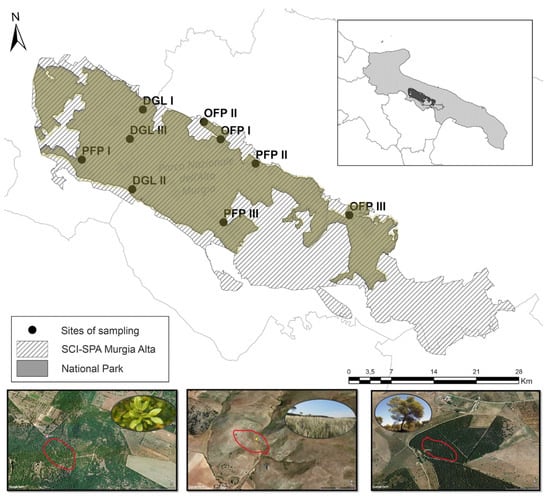
Habitat networks can help to make habitats more resilient and assist species survival in a fragmented landscape and changing climate. Butterflies are one of the main indicators of diversity due to their high sensitivity to environmental changes. In the context of sudden and [...] Read more.
Habitat networks can help to make habitats more resilient and assist species survival in a fragmented landscape and changing climate. Butterflies are one of the main indicators of diversity due to their high sensitivity to environmental changes. In the context of sudden and unpredictable environmental changes, protection strategies for butterflies at risk of extinction should consider the exact distribution of these species, as well as the various threats to which each of them is subjected. About 290 species of butterflies are reported in Italian fauna, and 120 of them are recorded in Apulia (Southern Italy). In the Alta Murgia National Park (AMNP) (Apulia Region, Italy), screening was performed to study the relationships between area/landscape composition and diurnal butterfly community structure. Representative semi-natural habitats of Alta Murgia buffering productive crops were selected to set up transects/paths along dry grasslands, oak forests and pine forests. Monthly samplings were performed for one year. During the survey, 909 specimens from 53 species were collected. The highest values of butterfly’s abundance and richness were recorded in dry grasslands. A strong positive correlation between butterfly abundance and air temperature was registered (Pearson correlation: r = 0.8; p < 0.001). Melanargia arge, endemic in central-southern Italy and considered threatened in Europe (Annexes II and IV—Habitats Directive), was registered in each habitat. The biodiversity indices (Chao 1, Shannon and Simpson) for each habitat were high and similar to those in protected areas of Sicily. The connected landscape is important for generalist or open-habitat specialists, and large remnants are key for disturbance-sensitive and threatened taxa. The presented evidence can provide useful information on butterfly conservation in the AMNP and for the management and conservation of characteristic landscapes of Alta Murgia. Full article
Show Figures

Figure 1

18 pages, 633 KiB  
Article
Unravelling Consumer Preferences and Segments: Implications for Pakistan’s Mandarin Industry Development through Market Relocation
by Hammad Badar, Azhar Abbas, Khalid Mushtaq, Thomas Dogot, Philippe Lebailly, Yenny Katherine Parra-Acosta, Hossein Azadi and David López-Carr
Land 2023, 12(5), 953; https://doi.org/10.3390/land12050953 - 25 Apr 2023
Cited by 1 | Viewed by 1814
Abstract
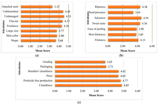
Rising food security and safety concerns in developing countries have highlighted the importance of establishing efficient and dependable food distribution systems, which necessitate a thorough understanding of consumers and their needs. Thus, this study unravels consumer segments, their preferences, and socio-economic composition so [...] Read more.
Rising food security and safety concerns in developing countries have highlighted the importance of establishing efficient and dependable food distribution systems, which necessitate a thorough understanding of consumers and their needs. Thus, this study unravels consumer segments, their preferences, and socio-economic composition so that stakeholders in Pakistan’s mandarin (locally known as Kinnow) industry can improve their practices and supply consumers’ desired quality. Primary data were collected through an intercept survey of 540 mandarin consumers in four major cities of Pakistan. Collected data were subjected to hierarchical cluster analysis, Mean ANOVA, and Post-Hoc tests for consumer segmentation and profiling. The study classified consumers into three groups: ‘value seekers’ (45.74%), ‘Kinnow lovers’ (26.85%), and ‘perfectionists’ (27.41%) related to their choice of various attributes of fresh mandarin fruits. The three segments significantly differed in their preferences for quality attributes, consumption and purchase preferences, and socio-economic composition. The study highlights the implications of understanding consumer preferences and market segmentation for private and public stakeholders in the mandarin industry. The existence of consumer segments with distinct quality preferences urges value chain actors to upgrade and align their practices with consumer requirements. The study findings provide insights for deciding relevant crop/cultivar mix with due consideration to geographically distinct consumer segments and land suitability. The findings may also be useful to relevant public-sector institutions in developing policies and programs for the development of the horticultural industries in Pakistan. Full article
Show Figures

Figure 1

27 pages, 16083 KiB  
Article
Drivers of Degradation of Croplands and Abandoned Lands: A Case Study of Macubeni Communal Land in the Eastern Cape, South Africa
by Silindile Sibiya, Jai Kumar Clifford-Holmes and James Gambiza
Land 2023, 12(3), 606; https://doi.org/10.3390/land12030606 - 3 Mar 2023
Cited by 1 | Viewed by 3602
Abstract
Soil erosion is a global environmental problem and a pervasive form of land degradation that threatens land productivity and food and water security. Some of the biggest sources of sediment in catchments are cultivated and abandoned lands. However, the abandonment of cultivated fields [...] Read more.
Soil erosion is a global environmental problem and a pervasive form of land degradation that threatens land productivity and food and water security. Some of the biggest sources of sediment in catchments are cultivated and abandoned lands. However, the abandonment of cultivated fields is not well-researched. Our study assesses the level of degradation in cultivated and abandoned lands using a case study in South Africa. We answer three main questions: (1) What is the extent of crop field degradation on used, partly used, and abandoned fields? (2) What are the drivers of field abandonment in relation to land degradation? (3) Can proposed sustainable land management interventions tackle the dynamics of land abandonment and associated degradation? To answer these questions, cultivated and abandoned lands were mapped in a pilot catchment with ArcGIS tools and assigned severity codes and classified according to status, degradation, and encroachment. Systems diagrams were developed to show the interactions between agricultural land use and the level of degradation and leverage points in the system, with interventions assessed via a multi-criteria analysis. The results revealed that 37% of the total mapped area of croplands in the pilot site was abandoned and 20% of those lands were highly degraded. We argue that the innovative application of systems thinking through causal loop diagrams (CLDs) and leverage point analysis, combined with spatial and multi-criteria analyses, can assist with planning SLM interventions in similar contexts in the developing world. Full article
Show Figures

Figure 1

17 pages, 9940 KiB  
Article
The Driving Role of 3D Geovisualization in the Reanimation of Local Collective Memory and Historical Sources for the Reconstitution of Rural Landscapes
by Dimitris Goussios and Ioannis Faraslis
Land 2023, 12(2), 364; https://doi.org/10.3390/land12020364 - 29 Jan 2023
Cited by 5 | Viewed by 3736
Abstract
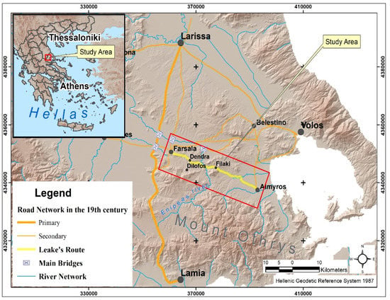
The dynamics created by the process of territorial construction are partly based on the selective and functional incorporation of heritage. However, in rural areas, retrospection presents particular difficulties due to a lack of appropriate information. Τhis research proposes the implementation of a methodology [...] Read more.
The dynamics created by the process of territorial construction are partly based on the selective and functional incorporation of heritage. However, in rural areas, retrospection presents particular difficulties due to a lack of appropriate information. Τhis research proposes the implementation of a methodology that combines sources, methods, and tools where the extraction of timeless information is based on the use of 3D interactive representations incorporating the active participation of actors and their collective memory. The proposed methodology strives for the compatibility, objectivity, and synergy of information from various sources and historical periods. The scope of this research concerns the mapping of the route and landscapes that were explored and described by the traveller Leake 210 years ago in the Farsala-Almyros area in Thessaly (Greece). The results focus on the reconstruction of the spatial subsystems of land use and exploitation at the beginning of the 19th century. The analysis reveals a production system, organized to use the laws of nature in order to sustainably manage the relationship between humans, animals, and natural resources. At the same time, the comparison with the current space has revealed a serious degradation in the natural environment since then. Finally, this mixed methodology, by combining the “spatialization” of information, virtuality and interactivity, the transition in time and space, and, finally, the “territorialization” of information, forms the basis for the inclusion of the history of places in the modern process of constructing a territorial area. Full article
Show Figures

Figure 1

2022

Jump to: 2023, 2021, 2020

24 pages, 2117 KiB  
Article
Approaches to Enhance Integration and Monitoring for Social-Ecological Systems
by Adela Itzkin, Jai Kumar Clifford-Holmes, Mary Scholes and Kaera Coetzer
Land 2022, 11(10), 1848; https://doi.org/10.3390/land11101848 - 20 Oct 2022
Cited by 2 | Viewed by 2460
Abstract
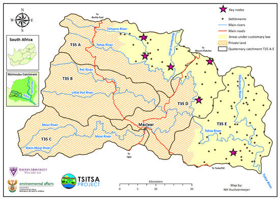
Integration and monitoring are pressing conceptual and methodological challenges in social-ecological systems (SES) research. This paper follows a social learning process, called participatory self-observation, piloted by a group of action-researchers to improve SES integration and monitoring, using the Tsitsa River Catchment in South [...] Read more.
Integration and monitoring are pressing conceptual and methodological challenges in social-ecological systems (SES) research. This paper follows a social learning process, called participatory self-observation, piloted by a group of action-researchers to improve SES integration and monitoring, using the Tsitsa River Catchment in South Africa as a case study. The participatory self-observation process reflected on lessons to enhance integration and integrated monitoring of biophysical, social, and social-ecological data in SES projects; for adaptive planning and management. Three focal points emerged for improving the challenges of SES integration: the need for participatory people-based processes, the importance of applied praxis tasks to catalyze meaningful integration, and the need for transdisciplinary teams to value non-biophysical research. Five focal areas emerged as major challenges for SES monitoring: the integration of qualitative and quantitative data, data overload, the scale of SES monitoring, the need to center SES monitoring around learning, and good working relationships to enable data flow. Recommendations to further develop integrated monitoring and management of SESs include (i) using people-based approaches that focus on applied work which includes rigorous collection of quantitative, biophysical data, (ii) identifying essential data needs through an essential variable approach, and (iii) combining quantitative monitoring with participatory people-based processes. Full article
Show Figures

Figure 1

23 pages, 3966 KiB  
Article
Land Use Changes for Investments in Silvoarable Agriculture Projected by the CLUE-S Spatio-Temporal Model
by Stamatia Nasiakou, Michael Vrahnakis, Dimitrios Chouvardas, Georgios Mamanis and Vassiliki Kleftoyanni
Land 2022, 11(5), 598; https://doi.org/10.3390/land11050598 - 19 Apr 2022
Cited by 14 | Viewed by 3390
Abstract
Investment in biology-based technological innovations is a key requirement for the development of modern agriculture/forestry. The expansion of innovative biological technologies includes changes in crops/cultivations, such as the transition from intensive monocultures to multiple crops of lower agrochemical inputs with the integration of [...] Read more.
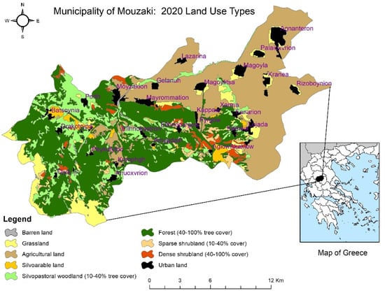
Investment in biology-based technological innovations is a key requirement for the development of modern agriculture/forestry. The expansion of innovative biological technologies includes changes in crops/cultivations, such as the transition from intensive monocultures to multiple crops of lower agrochemical inputs with the integration of woody trees/shrubs or animals, represented by Agroforestry. This innovative biological technology is further promoted at the European Union (EU) level by powerful institutions such as the Green Deal and the new CAP, mainly by tools such as ecoschemes and agri-environmental and climate measures (AECMs). The use of integrated regional spatiotemporal models, such as CLUE-S, to predict land use changes in the framework of Agroforestry is rather restricted. This paper examines Agroforestry as a vehicle that can contribute to achieving the rural development of the region of Thessaly, Greece. It sets a time horizon for reviewing the changes that are expected in the most important units of land uses of the rural landscape of the municipality of Mouzaki, western Thessaly plain, in the year 2040, which serves as model land for the region of Thessaly. It examines these changes with the effect of three (3) socio-economic scenarios: (a) a linear operating scenario (business as usual, BAU), (b) an ecological land protection (ELP) scenario, and (c) a rapid economic development (RED) scenario. These scenarios were introduced in the non-spatial module of the CLUE-S spatiotemporal model, while in the spatial module sixteen (16) characteristic landscape parameters were introduced as independent variables. The most important land use units, including traditional silvoarable and silvopastoral woodland systems, were the dependent variables. The simulations of the changes of the land use units showed that under the RED scenario, in the year 2040 the extent of the silvoarable systems is expected to increase significantly (57%) compared to the reference year of 2020, while the rest of the land use units under the other scenarios are mainly regulated by depopulation/abandonment of the rural areas and the processes of natural succession. The fact that the extent of silvoarable systems is increasing, in combination with the favorable institutional environment created by European rural policies, gives impetus to regional rural development through investments in the agricultural sector and mainly in Agroforestry systems. Full article
Show Figures

Figure 1

10 pages, 2392 KiB  
Article
Online Environment as a Tool to Push Forward the Research: An Example for Landscape Disservices
by Ileana Pătru-Stupariu, Andreea Ionescu, Radu Tudor, Alin-Ionuț Pleșoianu and Mioara Clius
Land 2022, 11(2), 234; https://doi.org/10.3390/land11020234 - 4 Feb 2022
Cited by 1 | Viewed by 1713
Abstract
Due to the COVID-19 pandemic, researchers have had to find different resources in order to continue their research and the use of online information can represent a temporary solution. Our research is mainly focusing on a landscape which offers services and disservices. Recently, [...] Read more.
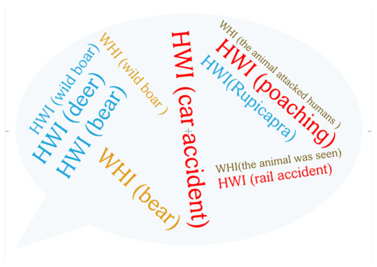
Due to the COVID-19 pandemic, researchers have had to find different resources in order to continue their research and the use of online information can represent a temporary solution. Our research is mainly focusing on a landscape which offers services and disservices. Recently, numerous studies that rely on landscape disservices have appeared. We associate wildlife-human-interactions (WHI) and human-wildlife-interactions (HWI) as part of landscape disservices. More precisely, in the first category (WHI) we have included the interaction of the wild animals with human and in the second category (HWI) we have created a database with animals attacked or/and killed by human. In order to sustain this analysis, we have selected data from local newspapers and Facebook groups, which supports our hypothesis that online resources could provide valuable data. The study area is represented by the Southern and Eastern Carpathians. The most affected mammals for this type of interactions (HWI) are bears, followed by wild boars and red deer, while WHI has intensified in the last five years. Based on the analysed data we can conclude that the animals who generate the most disservices to humans are bears and wild boars. The solutions we have identified, which also include online sources, for both HWI and WHI are relocation, rescue, capturing of the animals in reservations or, as a last resort, euthanasia. In order to reduce these types of interactions it is important to promote ecological education, development and promoting of certain attitudes and behaviour that have a visible impact upon HWI and WHI. Full article
Show Figures

Figure 1

2021

Jump to: 2023, 2022, 2020

13 pages, 4224 KiB  
Article
Sustainable Landscape Planning to Mitigate Wildlife–Vehicle Collisions
by Ancuta Fedorca, Mihai Fedorca, Ovidiu Ionescu, Ramon Jurj, Georgeta Ionescu and Marius Popa
Land 2021, 10(7), 737; https://doi.org/10.3390/land10070737 - 14 Jul 2021
Cited by 16 | Viewed by 4292
Abstract
Road development, traffic intensification, and collisions with wildlife represent a danger both for road safety and species conservation. For planners, deciding which mitigation methods to apply is often problematic. Through a kernel density estimate, we analyzed 715 crossing locations and wildlife–vehicle collisions (WVCs) [...] Read more.
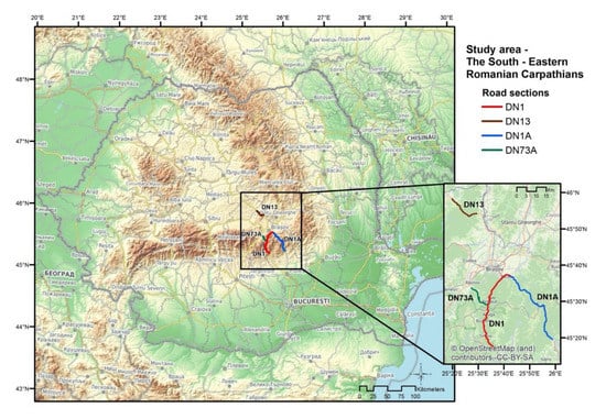
Road development, traffic intensification, and collisions with wildlife represent a danger both for road safety and species conservation. For planners, deciding which mitigation methods to apply is often problematic. Through a kernel density estimate, we analyzed 715 crossing locations and wildlife–vehicle collisions (WVCs) involving brown bears, lynx, wolf, red deer, roe deer, and wild boar in the Southeastern Carpathian Mountains. We identified 25 WVC hotspots, of which eight require urgent mitigation of existing infrastructure. Moreover, many of these hotspots are in Natura 2000 sites, along road sections where vegetation is in close proximity, animal movement is the highest, and driver visibility is low. Our study is the first in Romania to recommend practical solutions to remediate WVC hotspots and benefit sustainable landscape management. Full article
Show Figures

Figure 1

15 pages, 995 KiB  
Communication
Urban versus Rural? Conflict Lines in Land Use Disputes in the Urban–Rural Fringe Region of Schwerin, Germany
by Meike Fienitz and Rosemarie Siebert
Land 2021, 10(7), 726; https://doi.org/10.3390/land10070726 - 10 Jul 2021
Cited by 17 | Viewed by 4896
Abstract
Land use conflicts can present major obstacles to sustainable land management. An accurate understanding of their actor constellations and conflict lines is therefore crucial in developing tools for successful landscape governance. In this context, actors from cities and actors from rural areas are [...] Read more.
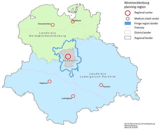
Land use conflicts can present major obstacles to sustainable land management. An accurate understanding of their actor constellations and conflict lines is therefore crucial in developing tools for successful landscape governance. In this context, actors from cities and actors from rural areas are often seen as typical opponents. Hence, the objective of this paper is to analyze the extent to which empirical conflict lines indeed run between urban and rural actors. We applied qualitative text analysis to examine 124 land use conflicts in the urban–rural fringe of Schwerin, Germany, which were identified through semistructured interviews with key land use actors in the region. Results showed that actors from the city and the rural fringe were on opposing sides in almost half of the conflicts. However, they were also frequently in conflict among themselves, and many actor constellations involved actors from other regions or administrative levels. In conclusion, the narrative of the urban–rural dichotomy appears in the empirical data but does not appropriately convey the complexity of the actual conflict lines. The findings of this paper therefore emphasize that it is important to empirically identify the actor constellations in land use conflicts rather than rely on preconceived ideas about typical conflict lines. Full article
Show Figures

Figure 1

31 pages, 8427 KiB  
Article
Land Use Change, Urban Agglomeration, and Urban Sprawl: A Sustainable Development Perspective of Makassar City, Indonesia
by Batara Surya, Agus Salim, Hernita Hernita, Seri Suriani, Firman Menne and Emil Salim Rasyidi
Land 2021, 10(6), 556; https://doi.org/10.3390/land10060556 - 25 May 2021
Cited by 73 | Viewed by 10476
Abstract
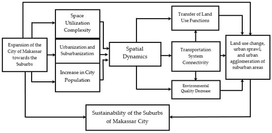
Urbanization towards the expansion of the city area causes urban sprawl and changes in space use. Furthermore, urban agglomeration towards urban spatial integration causes a decrease in environmental quality. This study aims to analyze (1) land-use change and urban sprawl work as determinants [...] Read more.
Urbanization towards the expansion of the city area causes urban sprawl and changes in space use. Furthermore, urban agglomeration towards urban spatial integration causes a decrease in environmental quality. This study aims to analyze (1) land-use change and urban sprawl work as determinants of environmental quality degradation in suburban areas. (2) The effect of urban sprawl, urban agglomeration, land-use change, urban activity systems, and transportation systems on environmental quality degradation in suburban areas. A combination of quantitative and qualitative approaches is used sequentially in this study. Data obtained through observation, surveys, and documentation. The results showed that the expansion of the Makassar City area to the suburbs had an impact on spatial dynamics, spatial segregation, and environmental degradation. Furthermore, urban sprawl, land-use change, urban agglomeration, activity systems, and transportation systems have a positive correlation to environmental quality degradation with a determination coefficient of 85.9%. This study recommends the handling of urban sprawl, land-use change, and urban agglomeration to be considered in the formulation of development policies towards the sustainability of natural resources and the environment of Makassar City, Indonesia. Full article
Show Figures

Figure 1

13 pages, 4519 KiB  
Article
Assessment of Land-Use Scenarios at a National Scale Using Intensity Analysis and Figure of Merit Components
by Kikuko Shoyama
Land 2021, 10(4), 379; https://doi.org/10.3390/land10040379 - 5 Apr 2021
Cited by 8 | Viewed by 3409
Abstract
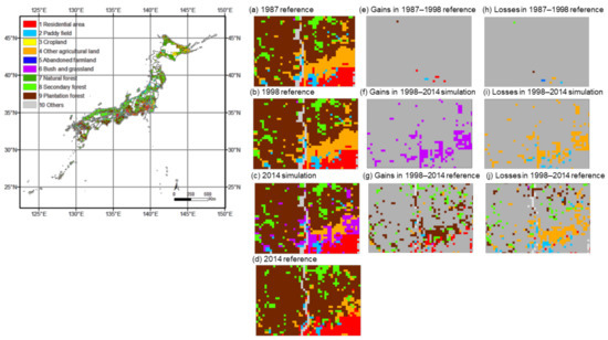
To address the impacts of future land changes on biodiversity and ecosystem services, land-use scenarios have been developed at the national scale in Japan. However, the validation of land-use scenarios remains a challenge owing to the lack of an appropriate validation method. This [...] Read more.
To address the impacts of future land changes on biodiversity and ecosystem services, land-use scenarios have been developed at the national scale in Japan. However, the validation of land-use scenarios remains a challenge owing to the lack of an appropriate validation method. This research developed land-use maps for 10 land-use categories to calibrate a land-change model for the 1987–1998 period, simulate changes during the 1998–2014 period, and validate the simulation for the 1998–2014 period. Following an established method, this study assessed the three types of land change: (1) reference change during the calibration time interval, (2) simulation change during the validation time interval, and (3) reference change during the validation time interval, using intensity analysis and figure of merit components (hits, misses, and false alarms). The results revealed the cause of the low accuracy of the national scale land-use scenarios as well as priority solutions, such as aligning the underlying spatial vegetation maps and improving the model to reduce two types of disagreement between the simulation and reference maps. These findings should help to improve the accuracy of model predictions and help to better inform policymakers during the decision-making process. Full article
Show Figures

Figure 1

11 pages, 9569 KiB  
Article
The Importance of Low-Intensive Agricultural Landscape for Birds of Prey
by Emanuel Ștefan Baltag, Viorel Pocora, Lucian Eugen Bolboaca and Constantin Ion
Land 2021, 10(3), 252; https://doi.org/10.3390/land10030252 - 2 Mar 2021
Cited by 2 | Viewed by 2742
Abstract
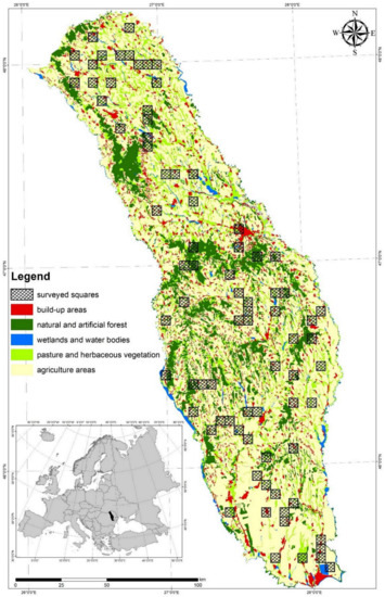
Low-intensive agricultural areas of Romania sustain high species diversity. Together with natural habitats, these areas are very important for European biodiversity. The ecosystem´s health is reflected in the predator status because of their position at the top of the trophic networks. The Common [...] Read more.
Low-intensive agricultural areas of Romania sustain high species diversity. Together with natural habitats, these areas are very important for European biodiversity. The ecosystem´s health is reflected in the predator status because of their position at the top of the trophic networks. The Common Buzzard (Buteo buteo) is the most common bird of prey species in Europe. During the first survey census conducted in Eastern Romania (2011–2012 breeding seasons), 8.55–10.35 breeding pairs/100 square km have been counted. The Common Buzzard density varies between breeding seasons and with differences in habitat structure. Their density is positively influenced by the density of forest edge and Simpson diversity index of habitats but is negatively influenced by the total habitat fragmentation and mean daily temperature. According to this analysis, the selection of breeding territories by common buzzards is positively influenced by a heterogeneous landscape in an area with low-intensive agriculture and with large areas of open habitats made up of natural or semi-natural vegetation. Full article
Show Figures

Figure 1

24 pages, 19371 KiB  
Article
Forest and Arborescent Scrub Habitats of Special Interest for SCIs in Central Spain
by Ana Cano-Ortiz, Carmelo M. Musarella, Jose C. Piñar Fuentes, Ricardo Quinto Canas, Carlos J. Pinto Gomes, Giovanni Spampinato, Jehad Mahmoud Hussein Ighbareyeh, Sara del Río and Eusebio Cano
Land 2021, 10(2), 183; https://doi.org/10.3390/land10020183 - 10 Feb 2021
Cited by 6 | Viewed by 3550
Abstract
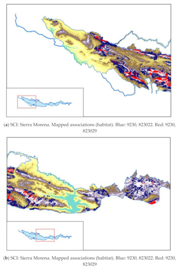
The habitat of the several territories in Ciudad Real (Castilla-La Mancha, Spain) are studued through the and mapping (scale 1:10.000) and vegetation analysis. The distribution and surface of the habitat presents in the Sites of Community Interest (SCIs), as well as pressures, threats, [...] Read more.
The habitat of the several territories in Ciudad Real (Castilla-La Mancha, Spain) are studued through the and mapping (scale 1:10.000) and vegetation analysis. The distribution and surface of the habitat presents in the Sites of Community Interest (SCIs), as well as pressures, threats, trends, and state of conservation are described. These site contributes significantly to the maintenance or restoration at a favourable conservation status of a natural habitat type or of a species of community intesess.These specially protected areas are part of the Natura 2000 network. We discuss the diversity of forest habitats characterized by species of the genus Quercus L., focusing only on the plant communities in the Habitats Directive 92/43/EEC of 1992, regarding the conservation of fauna and flora and habitats of interest owing to their endemic or rare character. Habitats and species must be studied in combination to ensure the maximum reliability of the results. We concentrate on habitats with low representation in the territory as a consequence of their rarity or endemicity. We study the following habitats of special interest: 9230—Mediterranean-Ibero-Atlantic and Galaico-Portuguese oak woods of Quercus robur and Quercus pyrenaica; 9240—Iberian oaks of Quercus faginea and Quercus canariensis; 9320—Thermomediterranean forests of Olea and Ceratonia (Iberian Peninsula, Balearic and Canary Islands); 9540—Mediterranean pine forests of endemic Pinus pinaster (Pinus pinaster subsp. acutisquama); 9560—Endemic forests with Juniperus spp.; 5210. Arborescent scrub with Juniperus spp. Full article
Show Figures

Figure 1

21 pages, 4857 KiB  
Article
Using Landscape Change Analysis and Stakeholder Perspective to Identify Driving Forces of Human–Wildlife Interactions
by Mihai Mustățea and Ileana Pătru-Stupariu
Land 2021, 10(2), 146; https://doi.org/10.3390/land10020146 - 2 Feb 2021
Cited by 12 | Viewed by 3226
Abstract
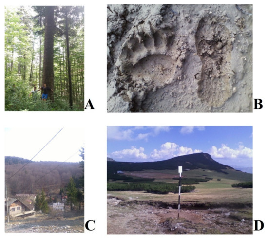
Human–wildlife interactions (HWI) were frequent in the post-socialist period in the mountain range of Central European countries where forest habitats suffered transitions into built-up areas. Such is the case of the Upper Prahova Valley from Romania. In our study, we hypothesized that the [...] Read more.
Human–wildlife interactions (HWI) were frequent in the post-socialist period in the mountain range of Central European countries where forest habitats suffered transitions into built-up areas. Such is the case of the Upper Prahova Valley from Romania. In our study, we hypothesized that the increasing number of HWI after 1990 could be a potential consequence of woodland loss. The goal of our study was to analyse the effects of landscape changes on HWI. The study consists of the next steps: (i) applying 450 questionnaires to local stakeholders (both citizens and tourists) in order to collect data regarding HWI temporal occurrences and potential triggering factors; (ii) investigating the relation between the two variables through the Canonical Correspondence Analysis (CCA); (iii) modelling the landscape spatial changes between 1990 and 2018 for identifying areas with forest loss; (iv) overlapping the distribution of both the households affected by HWI and areas with loss of forested ecosystems. The local stakeholders indicate that the problematic species are the brown bear (Ursus arctos), the wild boar (Sus scrofa), the red fox (Vulpes vulpes) and the grey wolf (Canis lupus). The number of animal–human interactions recorded an upward trend between 1990 and 2018, and the most significant driving factors were the regulation of hunting practices, the loss of habitats, and artificial feeding. The landscape change analysis reveals that between 1990 and 2018, the forest habitats were replaced by built-up areas primarily on the outskirts of settlements, these areas coinciding with frequent HWI. The results are valid for both forest ecosystems conservation in the region, wildlife management, and human infrastructures durable spatial planning. Full article
Show Figures

Figure 1

2020

Jump to: 2023, 2022, 2021

18 pages, 5062 KiB  
Article
How Do Natura 2000 Areas Intersect with Peoples’ Livelihood Strategies in High Nature Value Farmlands in Southern Transylvania?
by Georgiana Toth, Alina Huzui-Stoiculescu, Alexandru-Ioan Toth and Robert Stoiculescu
Land 2020, 9(12), 484; https://doi.org/10.3390/land9120484 - 1 Dec 2020
Cited by 7 | Viewed by 2756
Abstract
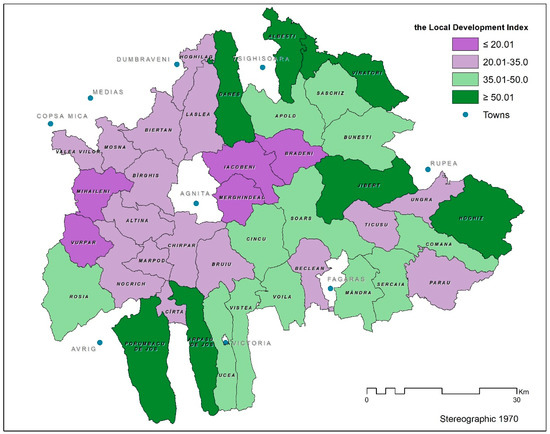
The establishment of the Natura 2000 network in Romania constitutes a turning point for the policy on biodiversity conservation in this country. The presence of human communities in certain Natura 2000 areas determines complex interactions between social and ecological systems, particularly in the [...] Read more.
The establishment of the Natura 2000 network in Romania constitutes a turning point for the policy on biodiversity conservation in this country. The presence of human communities in certain Natura 2000 areas determines complex interactions between social and ecological systems, particularly in the case of High Nature Value farmlands that are assigned to this network of protected natural areas. A large part of Romania’s biodiversity depends on traditional farming systems that are under pressure from either agricultural intensification or land abandonment, which reflects socio-economic changes that have pushed rural households into developing new livelihood strategies. This paper explores the particular context of traditional rural communities from Southern Transylvania which is a High Nature Value farmland area largely included in the Natura 2000 network. We conducted an empirical analysis that focused on two main issues. The first was applying quantitative methods aimed at identifying the linkages between livelihood capitals and livelihood strategies of people living in Natura 2000 areas. The second was analyzing differences in local development levels which correlate with the share of territorial administrative units belonging to Natura 2000 areas. Our results are based on questionnaire and interview data collected from 40 rural administrative-territorial units within Southern Transylvania as well as on mapping land use changes using Landsat satellite images of 1985, 2003 and 2015. The results indicate that rural communities living in Natura 2000 areas turn to migration as an additional household strategy besides usual on-farm and off-farm activities, leading to rural shrinkage and farmland abandonment. Full article
Show Figures

Figure 1

18 pages, 5064 KiB  
Article
Temporal Continuities of Grasslands and Forests as Patches of Natural Land in Urban Landscapes: A Case Study of the Tsukuba Science City
by Shoma Jingu
Land 2020, 9(11), 425; https://doi.org/10.3390/land9110425 - 31 Oct 2020
Cited by 1 | Viewed by 3068
Abstract
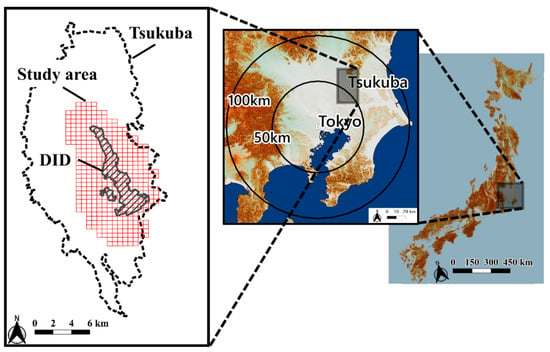
Development has fragmented urban nature, and target sites for conservation strategies need to be those that have long maintained their original land cover in a clustered area. Additionally, continuously grasping changes from rural to urban as well as changes over decades after urbanization [...] Read more.
Development has fragmented urban nature, and target sites for conservation strategies need to be those that have long maintained their original land cover in a clustered area. Additionally, continuously grasping changes from rural to urban as well as changes over decades after urbanization is essential. Therefore, this study identified and investigated natural patches in urban landscapes, clarified actual management practices in the identified patches, and traced changes in land ownership and land cover during the past 130 years in the Tsukuba Science City, Japan. We first identified areas containing clusters of urban grasslands and forest patches that have existed since the 2010s. We then identified urban green space patches that since the 1880s have remained undeveloped after being agricultural landscapes, despite the rapid urbanization of the Tsukuba Science City since the 1970s. These patches of urban green space were mainly identified near rural communities, research institutions, planned development sites, and golf courses. The findings of this study highlighted the need for new policy implications through systematic arrangement of diverse conservation strategies to maintain urban green space patches. Further investigation is required to elucidate the ecosystem services provided by these remnant green patches. Full article
Show Figures

Figure 1

21 pages, 1208 KiB  
Review
A Review of Changes in Mountain Land Use and Ecosystem Services: From Theory to Practice
by Ileana Pătru-Stupariu, Constantina Alina Hossu, Simona Raluca Grădinaru, Andreea Nita, Mihai-Sorin Stupariu, Alina Huzui-Stoiculescu and Athanasios-Alexandru Gavrilidis
Land 2020, 9(9), 336; https://doi.org/10.3390/land9090336 - 22 Sep 2020
Cited by 25 | Viewed by 6160
Abstract
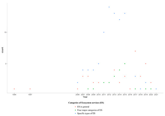
Global changes impact the human-environment relationship, and, in particular, they affect the provision of ecosystem services. Mountain ecosystems provide a wide range of such services, but they are highly sensitive and vulnerable to change due to various human pressures and natural processes. We [...] Read more.
Global changes impact the human-environment relationship, and, in particular, they affect the provision of ecosystem services. Mountain ecosystems provide a wide range of such services, but they are highly sensitive and vulnerable to change due to various human pressures and natural processes. We conducted a literature survey that focused on two main issues. The first was the identification of quantitative methods aimed at assessing the impact of land use changes in mountain regions and the related ecosystem services. The second was the analysis of the extent to which the outcomes of these assessments are useful and transferable to stakeholders. We selected papers through a keyword-driven search of the ISI Web of Knowledge and other international databases. The keywords used for the search were mountain land use change and ecosystem service. Quantitative approaches to ecosystem service assessment rely on suitable indicators, therefore land use/land cover can be used as an appropriate proxy. Landscape metrics are a powerful analytical tool; their use can increase the accuracy of assessments and facilitate the mitigation of specific phenomena, such as fragmentation or the reduction of core habitat areas. Mapping is essential: it is the basis for spatial analyzes and eases the interactions between stakeholders. Land use/land cover change is a temporal process, so both past and future approaches are meaningful. It is necessary to enhance information transfer from theory to practice. Increasing stakeholder awareness can lead to suitable management solutions, and, reciprocally, stakeholder feedback can help improve current assessment methodologies and contribute to developing new tools that are suitable for specific problems. Full article
Show Figures

Figure 1

43 pages, 7705 KiB  
Article
Degradation of Coastlines under the Pressure of Urbanization and Tourism: Evidence on the Change of Land Systems from Europe, Asia and Africa
by Alexandru-Ionuţ Petrişor, Walid Hamma, Huu Duy Nguyen, Giovanni Randazzo, Anselme Muzirafuti, Mari-Isabella Stan, Van Truong Tran, Roxana Aştefănoaiei, Quang-Thanh Bui, Dragoş-Florian Vintilă, Quang Hai Truong, Cristina Lixăndroiu, Diana-Doina Ţenea, Igor Sîrodoev and Ioan Ianoş
Land 2020, 9(8), 275; https://doi.org/10.3390/land9080275 - 17 Aug 2020
Cited by 64 | Viewed by 8548
Abstract
The importance of studying coastal areas is justified by their resources, ecosystem services, and key role played in socio-economic development. Coastal landscapes are subject to increasing demands and pressures, requiring in-depth analyses for finding appropriate tools or policies for a sustainable landscape management. [...] Read more.
The importance of studying coastal areas is justified by their resources, ecosystem services, and key role played in socio-economic development. Coastal landscapes are subject to increasing demands and pressures, requiring in-depth analyses for finding appropriate tools or policies for a sustainable landscape management. The present study addresses this issue globally, based on case studies from three continents: Romania (Europe), Algeria (Africa), and Vietnam (Asia), focusing on the anthropogenic pressure resulting from land use/land cover change or urban sprawl, taking into account the role of socioeconomic and political factors. The methodology consisted of producing maps and computing and analyzing indicators, correlating geospatial and socio-economic data in a synergistic manner to explore the changes of landscapes, and identify the specific driving forces. The findings show that the pressure of urbanization and tourism on coastal areas increased, while the drivers and impacts vary. Urbanization is due to derogatory planning in Romania and Algeria, and different national and local goals in Vietnam. The two drivers determine local exemptions from the national regulations, made for profit. In addition to the need for developing and enforcing policies for stopping the degradation and restoring the ecosystems, the findings underline the importance of international cooperation in policy development. Full article
Show Figures

Graphical abstract

Back to TopTop