Article

Sandstone Layer Connectivity and Its Control on Coalbed Methane (CBM) Accumulation Based on Sequence Stratigraphic Analysis: A Case Study of the Lower Shihezi Formation in Qinan Coal Mine, Xuzhou–Suzhou Region, China

1
Key Laboratory of Coalbed Methane Resources and Reservoir Formation Process, Ministry of Education, China University of Mining and Technology, Xuzhou 221008, China
2
School of Resources and Geosciences, China University of Mining and Technology, Xuzhou 221116, China
*
Author to whom correspondence should be addressed.
Energies 2024, 17(3), 634; https://doi.org/10.3390/en17030634
Submission received: 6 December 2023 / Revised: 5 January 2024 / Accepted: 11 January 2024 / Published: 28 January 2024
(This article belongs to the Special Issue Coalbed Methane Exploration and Production)

Abstract

:
The sandstone layer connectivity in coal measure strata is one of the key factors in CBM escape in underlying coal seams, which lacks systematic research currently. This study aimed to explore sandstone layer connectivity and its control on CBM accumulation, taking the Lower Shihezi Formation in Qinan Coal Mine, Xuzhou–Suzhou Region, China, as a case study; to do so, we studied the No. 7 coal CBM unit, the pore-rich sandstone layers, and their connectivity modes by performing sequence stratigraphic analysis on the borehole cores, the logging data, and the theory of sequence stratigraphy and sedimentology, combined with the accumulation characteristics of the No. 7 coal seam CBM. This study shows the following: (1) The sequence stratigraphic framework of the Lower Shihezi Formation in the research region consists of two third-class sequences and six system tracts. (2) The No. 7 coal seam CBM unit includes the CBM formation layer, the connectivity layer, and the stable capping layer. (3) There are 10 types of parasequences in the No. 7 coal connectivity layer, and the pore-rich sandstone layers are all located in the connectivity layer and connected in three modes (vertical connectivity, lateral connectivity, and non-connectivity). (4) The connectivity modes and the thickness of pore-rich sandstone layers control the CBM accumulation in the region. Where the pore-rich sandstone layers are thickest and display vertical connectivity, the strong CBM desorption and escape lead to low CBM; where the pore-rich sandstone layers are thinnest and unconnected, the weak to no CBM desorption and escape result in high CBM. (5) Three models for sandstone layer connectivity and its control on CBM accumulation include the CBM weak accumulation model with a strong source supply, large basin subsidence, and undercompensation deposition; the CBM moderate accumulation model with a moderate source supply, moderate basin subsidence, and overcompensation to isostatic compensation deposition; and the CBM strong accumulation model with a weak source supply, small basin subsidence, and undercompensation deposition.

1. Introduction

CBM has long been a challenge for the global coal mining industry, and it is of great significance for safe operations and CBM prevention in coal mines to analyze the geological laws governing the gas. As of now, research in the global coal mining industry focuses on the geological factors that control CBM accumulation, including metamorphic degree, coal quality, geological structure, hydrogeology, lithology of the coal roof and floor strata, sedimentary environments of coal roof and floor strata, coal seam burial depth, overlying bedrock thickness, coal seam thickness, coal body structure, magmatic rock, etc. [1,2,3,4,5]. These factors have been extensively studied, leading to an enhanced understanding. Among the existing studies, studies belonging to the deposition control on CBM accumulation focus on the lithology of the coal roof and floor strata, the sedimentary environments of coal roof and floor strata, and the coal seam thickness. Beamish et al. (1998) [6] argued that a large coal seam thickness is very favorable for CBM accumulation and coal and CBM outbursts. Petrosian (1983) [7] suggested that differences in coal seam thickness can result in an uneven distribution of CBM. Qin et al. (2000) [3] concluded that the lithology of the coal roof and floor strata is closely related to the CBM content. Wang (2017) [8] and Sun (2015) [9] proposed that the sedimentary environments of coal roof and floor strata, controlled by sequence stratigraphic background, determine the lithology and physical properties, which govern the CBM escape and accumulation.
The study of geological factors controlling the CBM accumulation in Qinan Coal Mine has focused on seven aspects, including coal quality, geological structure, coal seam burial depth, coal seam thickness, overlying bedrock thickness, lithology of the coal roof and floor strata, and magmatic rock [10,11]. The lithology of the coal roof and floor strata and the coal seam thickness belong to the study on the deposition control of CBM accumulation. Wang et al. (2020) [12] found that when the coal seam thickness in the research region exceeds 10 m, there is a greater degree of CBM accumulation. Shangguan (2010) [13] discovered that CBM accumulates when the lithology of the coal roof and floor strata consists of mudstone or siltstone, with poor permeability among these aspects.
In recent years, the geological research on CBM in coal mines has encountered a bottleneck, with a dearth of new research directions for controlling CBM accumulation. To date, studies on the deposition control of CBM accumulation predominantly focus on the lithology of the coal roof and floor strata, the sedimentary environments of the coal roof and floor strata, and the coal seam thickness.
At present, there is a gap in the industry regarding the research of sandstone layer connectivity and its control on CBM accumulation based on sequence stratigraphic analysis. Taking the Lower Shihezi Formation in Qinan Coal Mine, Xuzhou–Suzhou, China, as a case study, an analysis of the connectivity models of sandstone layers has been conducted through sequence stratigraphic analysis. However, due to the lack of research on the detailed sequence stratigraphic background or framework on the Lower Shihezi Formation in Qinan Coal Mine, it was impossible to carry out model studies on the sandstone layer connectivity and its control on CBM accumulation. To address these issues, firstly, updating the sequence stratigraphic framework in the region was based on the analysis of sequence stratigraphic background. Secondly, an analysis of the CBM unit was conducted, determining the minimum isochronous stratigraphic unit through the sequence stratigraphy analysis, known as “parasequence”. Thirdly, the pore-rich sandstone and its connectivity modes under parasequences were defined. Finally, the models for sandstone layer connectivity and its control of CBM accumulation based on sequence stratigraphic analysis were proposed.

2. Geological Background

During the sedimentary period of the Lower Shihezi Formation in the Permian System, Qinan Mine in the Xuzhou–Suzhou Region was located at the southeastern margin of the North China Craton (Figure 1). It represented a shallow river-controlled delta sedimentary system of the Craton [14,15], with the development of sequence stratigraphy controlled by the competition between the land and sea.

2.1. The Sedimentary Evolution of the Permian Lower Shihezi Formation at the Southern Margin of the North China Craton

Since the end of the Carboniferous Period, the seawater in the North China Craton had generally receded to the southeast during frequent transgressions and regressions, resulting in a transitional facies during the entire Permian Period [16,17,18]. In the Early Permian Period, the North China Craton was uplifted overall, causing the seawater to gradually recede towards the southeast and leading to the development of a transitional facies. Fluvial processes intensified, resulting in the development of a delta sedimentary system with localized marine sedimentation [17]. The Shanxi Formation within the Permian Series primarily consists of dark-gray mudstone and gray-white medium to fine sandstone, interbedded with black carbonaceous mudstone and coal with the delta facies. The thickness variation in the Shanxi Formation is observed, with thicker sediments in the southern region compared to the northern region, and in the eastern region compared to the western region. At the early stage of the Middle Permian Period, the seawater further retreated, leading to differences in deposition between the southern and northern regions of the North China Craton. The southern region experienced a warm and humid delta environment, suitable for vegetation growth. The environment in the southern region resulted in thicker coal seams and sedimentary rocks compared to the northern region. The Lower Shihezi Formation within the Permian Series is characterized by the presence of green and gray-green mudstone, gray-white sandstone, and black coal with the delta facies [14,19]. The development of coal seams is more significant in the eastern region of the North China Craton than the western region. At the late stage of the Middle Permian Period, the North China Craton was uplifted again, causing the complete withdrawal of seawater and leading to the presence of a continental sedimentary. The climate changed from warm and humid to hot and dry during this period. The Upper Shihezi Formation with the Permian Series was dominated by fluvial facies, characterized by gray and red sedimentary rocks as a whole [18].

2.2. A Brief History of the Tectonic Evolution of the Permian Lower Shihezi Formation in the North China Craton

During the Permian Period, the North China Craton underwent multiple phases of oscillatory vertical movements [20]. In the early Permian Period, the North China Craton was subjected to continuous extrusion stress on the north and south sides, resulting in the uplift of the Craton [18,21]. However, the northern region of the craton was uplifted more intensely than the southern region, becoming the source supply region. In the late stage of the Middle Permian Period, the north and south sides of the North China Craton were extruded again, causing a further uplift of the Craton. The northern region of the craton remained the source supply region with a stronger uplift.

3. Sequence Stratigraphy of the Lower Shihezi Formation in Qinan Coal Mine, Xuzhou–Suzhou Region

A sequence is a relatively uniform and genetically linked set of strata bounded by unconformity surfaces and their corresponding conformity surfaces [22]. Sequence stratigraphic surfaces are boundaries of time attributes that reflect sedimentary discontinuities. These surfaces can be divided into different levels based on a sequence stratigraphic background. The background includes variations in source supply and changes in the base level controlled by an absolute sea level rise or fall and basin tectonic subsidence. In this section, the sequence stratigraphic development of the Lower Shihezi Formation in Qinan Coal Mine, Xuzhou–Suzhou Region, was analyzed through the principles of sequence stratigraphy and sedimentology. This analysis provided a foundation for subsequent parasequence analysis.

3.1. Sequence Stratigraphic Surface Analysis of the Lower Shihezi Formation in Qinan Coal Mine

The Lower Shihezi Formation in Qinan Coal Mine was formed during the time period of 258–270 million years ago [23]. The sequence stratigraphic surfaces (Figure 2) within this region were classified into third-class sequence stratigraphic surfaces and system tract surfaces, based on changes in the base level and source supply, as indicated by the borehole cores and logging data.

3.1.1. Third-Class Sequence Stratigraphic Surfaces

The third-class sequence stratigraphic surfaces of the Lower Shihezi Formation in Qinan Coal Mine include the regional regressive surface, the tectonism surface, and the Lower Shihezi Formation coal seam thinning surface.
(1)
The regional regressive surface
The regional regressive surface is a sedimentary boundary formed by a rapid decline in the base level due to the rapid decrease in the absolute sea level at the early stage of the Middle Permian Period in the Xuzhou–Suzhou Region. The surface represents a forced regressive surface, where lithological changes and sedimentary system transitions occur both above and below the surface. The top of the aluminum mudstone (Figure 2) of the Lower Shihezi Formation in Qinan Coal Mine corresponds to this surface. Below the surface, there is a stratum and lagoonal facies aluminum mudstone (Figure 3a) with abundant iron ooids of beach-bar facies. The stratum indicates a shallow marine sedimentary environment on the North China Craton [24], which, characterized by an overall flat terrain with local undulations, possessed a high base level and weak hydrodynamic conditions. Above the surface, closer to the source area, there is a stratum, delta facies sandstone with large grain sizes known as “bamboo-leaf sandstone” (Figure 2 and Figure 3b), while farther away from the source area, there is a stratum of sandy mudstone. The sandstone and sandy mudstone reflect the delta sedimentary environments of the North China Craton characterized by a low base level, strong hydrodynamic conditions, and an obvious incised erosion effect, due to the rapid decline in absolute sea level. The regional regressive surface is not only obviously different in lithology and sedimentary systems but also easy to identify in the logging data. The regional regressive surface reactions of X11#, X12#, X23#, and X24# boreholes show an obvious high amplitude of the GR logging curve and a significant low amplitude of the RT logging curve. The low amplitude of the RT logging curve gradually decreases above the surface, while below the surface, the low amplitude of the RT logging curve is even lower than above the surface (Figure 2).
(2)
The tectonism surface
The tectonism surface is a sedimentary boundary formed by the enhanced source supply due to the uplift of the source area at the late stage of the Middle Permian Period in the Xuzhou–Suzhou Region. The lithology above and below the surface shows significant changes, while the base level remained relatively stable. The features maintained the sedimentary characteristics of a delta plain facies. The bottom of the K3 sandstone (Figure 2) of the Upper Shihezi Formation in Qinan Coal Mine represents the tectonism surface. Below the surface, there is a stratum consisting of a large section of fine-grained and deep-colored mudstone within a delta facies, developed throughout the region. The mudstone represents the delta sedimentary environment in the North China Craton characterized by a scarce source supply and weak hydrodynamic conditions at the end of a sequence. Above the surface, there is a stratum consisting of coarse-grained and light-colored K3 sandstone within a delta facies, developed in the whole region. The sandstone indicates the delta sedimentary environment in the North China Craton with an increased source supply and strong hydrodynamic conditions at the beginning of a sequence. The tectonism surface is easily recognized in logging facies. Near the surface, the stepped curve shape of the GR and RT logging curves of X11#, X12#, X23#, and X24# boreholes is significantly denser, and the amplitude is larger. At the surface, the GR logging curve suddenly changes to a low amplitude, and the RT logging curve suddenly changes to a high amplitude (Figure 2).
(3)
The Lower Shihezi Formation coal seam thinning surface
The Lower Shihezi Formation coal seam thinning surface is a sedimentary interface formed by the slow decline in absolute sea level, which is a normal regressive surface in the Xuzhou–Suzhhou Region. The source supply above and below the surface is obviously weakened, resulting in a significant change in the thickness of the coal seams. The light-gray mudstone, without plant fossils, on the stable No. 6 coal seam (Figure 2) at the top of the lower section of the Lower Shihezi Formation in Qinan Coal Mine, represents the overall thinning surface of the Lower Shihezi Formation coal seams. Below the surface, the strata were formed by a delta plain to front sedimentary environments close to the sea, characterized by thickly developed coal seams, thick sandstone, estuary dam sandstone, many plant fossils in mudstone, occasional root clay, and bamboo-leaf sandstones at the lower part of a sequence. Above the surface, the strata were formed by a delta plain sedimentary environment far away from the sea and characterized by thinly developed coal seams, thin sandstone, missing estuary dam sandstone, few plant fossils in mudstone, and no bamboo-leaf sandstones at the lower part of a sequence. In addition, the logging of the Lower Shihezi Formation reveals that the stepped curve shapes of the GR and RT logging curves in X11#, X12#, X23#, and X24# boreholes exhibit denser variations in the lower formation compared to the upper formation. The GR logging curve in the lower formation has a lower amplitude, while the RT logging curve shows a higher amplitude. At the surface, there is a sudden transition of the GR logging curve to a high amplitude, while the RT logging curve undergoes a sudden transition to a low amplitude (Figure 2).

3.1.2. System Tract Surfaces

A system tract is a series of sedimentary system combinations with intrinsic connectivity during the same period [25]. System tract surface types respond to specific sedimentary periods in the global sea level change curve. According to the borehole cores and logging data, the main surfaces within system tracts, namely the first transgressive surface and the maximum transgressive surface (Figure 2), were identified.
(1)
The first transgressive surface
The first transgressive surface is formed by the first transgressive process during the development of sequence stratigraphy, marking the boundary between the lowstand system tract and the transgressive system tract [26]. It develops on top of the filled sedimentary sandstones in the incised valley [16,23]. In Qinan Coal Mine of the North China Craton, the lower part of the Lower Shihezi Formation, which was close to the sea, comprises a delta sedimentary system, mainly composed of coal and corresponding fine-grained mudstone, with plant fossils developed on the bamboo-leaf sandstone within the incised valley. The upper part of the Lower Shihezi Formation, which was far away from the sea, consists of a delta sedimentary system, primarily composed of coal and corresponding fine-grained mudstone developed on the thick sandstone within the incised valley. The No. 8 coal seam in the lower part and the No. 5 coal seam in the upper part of the Lower Shihezi Formation, and their corresponding mudstone (Figure 2), are the first transgressive surface. The thickness of the No. 8 coal seam is approximately 2 meters, while the thickness of the No. 5 coal seam is about 1 meter. These coal seams exhibit low GR logging values and high RT logging values.
(2)
The maximum transgressive surface
The maximum transgressive surface is formed by the maximum transgressive process during the development of sequence stratigraphy, representing the surface between the transgressive system tract and the highstand system tract. The surface responds to the highest absolute sea level in the research region, and the transgressive range reaches the maximum [16,23]. The impact of absolute sea level change on the formation and distribution of sediment rocks in the North China Craton is highly significant. Below this surface, the formation of the transgressive system tract was controlled by a rapid rise in the base level due to the vast increase in sea level, referring to a greater growth rate of accommodation space compared to the sediment supply rate. At the late stage of the transgressive system tract, the rising sea level led to a lack of coarse-grained clastic rocks in the research region, causing the abandonment of the delta sedimentary system. On the rocks, a coal seam was deposited. As a result, during the sedimentary period of the transgressive system tract, although the sea level was high, only the middle and lower parts of the system tract developed the estuary dam facies sandstone. Above this surface, the formation of the highstand system tract was primarily determined by source filling, resulting in no new accommodation space, as the sea level remains relatively stable. This led to the development of estuary dam sandstone and forest bed, the highstand system tract, overlapping above the maximum transgressive surface. The No. 7 and No. 4 coal seams (Figure 2) represent the maximum transgressive surface. The thickness of the No. 7 coal seam is approximately 5 meters, while the thickness of the No. 4 coal seam is about 3 meters. The coal seams exhibit lower GR logging values compared to the No. 8 and No. 5 coal seams, while their RT logging values are higher.

3.2. Sequence Stratigraphic Framework of the Lower Shihezi Formation in Qinan Coal Mine

Based on the sequence stratigraphic surface analysis of the Lower Shihezi Formation in Qinan Coal Mine, the sequence division of the Lower Shihezi Formation in the region was determined. A sequence stratigraphic framework (Figure 2) was summarized, comprising two third-class sequences, SQ1 and SQ2, and six system tracts. SQ1 represents the lower section of the Lower Shihezi Formation, while SQ2 corresponds to the upper section of the Lower Shihezi Formation.

3.2.1. Third-Class Sequence Division

At the end stage of the Late Carboniferous Period, the epicontinental sea sedimentary system in the North China Craton transitioned into a delta sedimentary system [16,17,18]. Previous studies concluded that the Permian Lower Shihezi Formation records a complete third-class sequence, along with a lowstand system tract and a transgressive system tract within another third-class sequence [23]. However, upon analyzing the stratigraphy in the region, the author discovered that the top of the Lower Shihezi Formation exhibits distinct characteristics of a third-class sequence surface, rather than the expected features of a system tract surface within a third-class sequence.
The above analysis indicates that the Lower Shihezi Formation in Qinan Coal Mine exhibits third-class sequence stratigraphic surfaces, including the regional regressive surface, the tectonism surface, and the Lower Shihezi Formation coal seam thinning surface. Two third-class sequences were identified within the Lower Shihezi Formation, separated by the coal seam thinning surface. The third-class sequence SQ1 of the Lower Shihezi Formation, referred to as SQ1, is situated below the surface. The third-class sequence SQ2 of the Lower Shihezi Formation, known as SQ2, is positioned above the surface. The lower boundary of SQ1 refers to the top of the aluminum mudstone corresponding to the regional regressive surface. The upper boundary of SQ1 is the No. 6 coal seam and the overlying light-gray mudstone section without plant fossils, which correspond to the Lower Shihezi Formation coal seam thinning surface. SQ1 formed during the beginning to end of the early stage of the Middle Permian Epoch Period and represents the lower part of the Lower Shihezi Formation. The lower boundary of SQ2 is the same as the upper boundary of SQ1. Its upper boundary is marked by the bottom of K3 sandstone, corresponding to the tectonism surface. SQ2 formed from the end of the early stage to the beginning of the late stage of the Middle Permian Period, encompassing the upper part of the Lower Shihezi Formation (Figure 2).

3.2.2. System Tract Division

According to the analysis of the system tract surfaces described above, the lowstand system tract, transgressive system tract, and highstand system tract were identified, and their respective characteristics were summarized.
(1)
The lowstand system tract
The lowstand system tract represents a period of a significant drop in the base level, leading to a deposition of the strongly scouring incised valley. The lower boundary of the system tract is characterized by a forced regressive surface or a normal regressive surface, and the upper boundary is marked by the first transgressive surface. In Qinan Coal Mine, the bottom of the SQ1 sequence lowstand system tract of the Lower Shihezi Formation is characterized by the bamboo-leaf sandstone on aluminum mudstone, formed by the forced regressive process, corresponding to a regional regressive surface. This is indicative of a rapid and large-scale decline in the base level. The top of the SQ1 sequence lowstand system tract is represented by the No. 8 coal seam, which was controlled by the first transgressive surface. The bottom of the SQ2 sequence lowstand system tract of the Lower Shihezi Formation is characterized by the thick sandstone on the No. 6 coal seam, controlled by the normal regressive process, corresponding to the Lower Shihezi Formation coal seam thinning surface. This indicates a slow and significant decline in the base level. The top of the SQ2 sequence lowstand system tract is represented by the No. 5 coal seam and its corresponding mudstone (Figure 2), which are formed by the first transgressive surface.
(2)
The transgressive system tract
The transgressive system tract represents a period of rapid rise in the base level, during which the increase rate in accommodation space exceeds the source supply rate, resulting in a reduced amount of sediments with small grain sizes. The lower boundary of the system tract represents the first transgressive surface, and the upper boundary represents the maximum transgressive surface. In Qinan Coal Mine, the top of the SQ1 sequence transgressive system tract of the Lower Shihezi Formation is characterized by the thickest coal seam, the No. 7 coal, which formed in a hydrostatic environment with a weak source supply. The bottom of the SQ1 sequence transgressive system tract is represented by thick sandstone developed while the sea level was rising, when it was not sufficient to effectively restrict an intense source supply. The SQ2 sequence transgressive system tract of the Lower Shihezi Formation is characterized by the overall development of the No. 4 coal seam, mudstone, and siltstone, which formed in a static water environment with a weakened source supply. Overall, the clastic particles in the SQ2 sequence transgressive system tract are smaller than those in the SQ1 sequence transgressive system tract. Moreover, the thickness of the No. 4 coal seam in the SQ2 sequence transgressive system tract is thinner than that of the No. 7 coal seam in the SQ1 sequence transgressive system tract (Figure 2). These observations reflect a reduction in the source supply and a further regression.
(3)
The highstand system tract
During a period in which the high-level system tract is always relatively stable, the base level does not change significantly, except for a decrease in the base level at the end of the deposition in the high-level system tract. Throughout the deposition period of the high-level system tract, there is basically no additional accommodation space, manifested in sediments occupying the accommodation space of a basin. The lower boundary of the high-level system tract is the maximum transgressive surface, and the upper boundary is either the regression surface or the tectonism surface. In Qinan Coal Mine, coarse-grained sandstone developed at the bottom of the SQ1 sequence highstand system tract, which was close to the source area. Conversely, fine-grained mudstone and siltstone containing plant fossils developed at the bottom of the SQ1 sequence highstand system tract, which was far from the source area. These observations reflect the obvious sedimentary differentiation. At the top of the SQ1 sequence highstand system tract, the development of the No. 6 coal seam and occasional root clay indicate the cessation of the source supply and abandonment of the delta sedimentary system. The SQ2 sequence highstand system tract of the Lower Shihezi Formation did not develop coarse-grained sandstone or coal but, instead, developed large sections of fine-grained mudstone (Figure 2) without plant fossils. This reflects the background of a fine-grained source supply with a high supply rate, far away from the sea.
The background of coal seam generation in each of the tract systems shows that coal can form throughout Qinan Coal Mine, during the abandonment phase of the delta sedimentary system when the source supply ceases or weakens, as long as the basin exists in the residual accommodation space and is close to the sea. The coal seam thickness within each system tract is similar throughout the entire region (Figure 4), indicating large-scale regional transgressions and regressions that occurred in the North China Craton Basin with a flat terrain. Furthermore, it is found that the thickness of coal seams in the western part of the research region, where there was a greater source supply, is comparable to that in the eastern part. This suggests that the western part of the research region experienced a greater subsidence.

4. Analysis of the No. 7 Coal Seam CBM Unit and Its Parasequences Based on Sequence Stratigraphic Background

As the basic unit of sequence stratigraphy, a parasequence is the basic unit to reflect the sequence stratigraphic background that refers to a base level and source supply change. It is the basic unit for the study of rock formation and sedimentary microfacies. It reflects the source filling before the transgressive surface or base level changes. In this section, according to the sequence background of the Lower Shihezi Formation, and the migration direction of No. 7 coal seam CBM in Qinan Coal Mine, the parasequences above the No. 7 coal seam were analyzed. The No. 7 coal seam CBM unit was defined. The No. 7 coal connectivity layer and its pore-rich sandstone layer were proposed. The parasequence types of the connectivity layer were analyzed in detail.

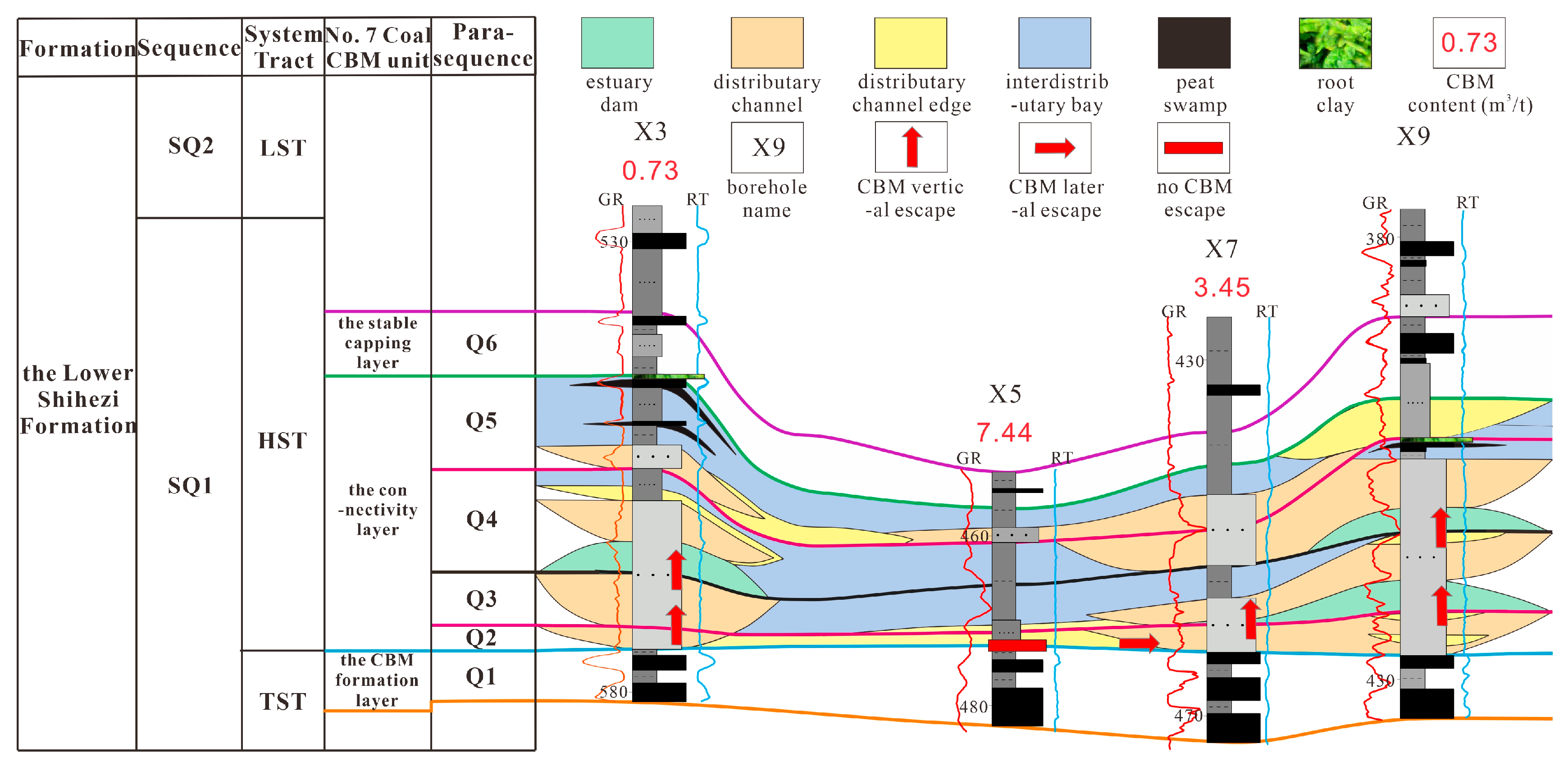
4.1. Analysis of the No. 7 Coal Seam CBM Unit and Its Parasequences Composition Based on Sequence Stratigraphic Background

The No. 7 coal seam CBM unit in Qinan Coal Mine includes the CBM formation layer, the connectivity layer, and the stable capping layer (Figure 5). A previous study [27] showed that the No. 7 coal seam of the Lower Shihezi Formation in Qinan Coal Mine is under a negative pressure state. The No. 7 coal seam CBM escaped to the upper strata and was sealed by stable fine-grained rocks. Therefore, the connectivity layer and the stable capping layer are located in the upper part of the No. 7 coal seam.
The formation of the No. 7 coal seam CBM unit was controlled by the sequence stratigraphic background. The CBM formation layer of the No. 7 coal seam CBM unit was developed in the late stage of the sedimentary period of the SQ1 sequence transgressive system tract. During this period, the source supply was scarce, and the sea level rose to the maximum transgressive surface. The thick No. 7 coal seam developed widely in the region because the plants grew in large quantities, which is referred to as the No. 7 coal CBM formation layer. The connectivity layer of the No. 7 coal seam CBM unit was formed in the early to middle stages of the sedimentary period of the SQ1 sequence highstand system tract. During this period, the source supply was increased, and the base level remained basically stable. Above the No. 7 coal seam, the sandstone, siltstone, and mudstone assemblages developed in this region, which is called the No. 7 coal connectivity layer. The connectivity layer can be divided into the No. 7 coal pore-rich sandstone layer and the No. 7 coal local capping layer. The pore-rich sandstone layer is composed of sandstone with good physical properties, and the local capping layer consists of sandstone with poor physical properties, siltstone, and mudstone (Figure 5). The stable capping layer of the No. 7 coal seam CBM unit was formed in the late stage of the sedimentary period of the SQ1 sequence highstand system tract. During this period, the source supply was scarce, and the base level decreased slowly. Because the plants grew, a combination of the No. 62 coal seam and mudstone developed extensively above the No. 7 coal seam in the region, which is referred to as the No. 7 coal stable capping layer. In general, the source supply in the early to middle stages of the SQ1 sequence highstand system tract is significantly stronger than that in the late stage of the SQ1 sequence highstand system tract and the late stage of the SQ1 sequence transgressive system tract. The No. 7 coal connectivity layer is characterized by a large grain size of clastic particles and an obvious sedimentary differentiation between the eastern and western regions in Qinan Coal Mine.
According to the parasequence analysis of the borehole cores and logging data in the research region, as well as the deposition rate of coal measure strata (generally not more than 6 cm/kyr) and a parasequence age range (usually not exceeding 0.5 Ma), the No. 7 coal seam CBM unit consists of six parasequences: Q1, Q2, Q3, Q4, Q5, and Q6. The No. 7 coal CBM formation layer represents the Q1 parasequence, with a single parasequence type. The vertical combination of the parasequence, from bottom to top, includes mudstone with interdistributary bay microfacies to coal with peat swamp microfacies. The stable capping layer of the No. 7 coal represents the Q6 parasequence, with a single parasequence type. The vertical combination of the parasequence, from bottom to top, also includes mudstone with interdistributary bay microfacies to coal with peat swamp microfacies. However, the coal seam is thin and unstable. The No. 7 coal connectivity layer consists of four parasequences, Q2, Q3, Q4, and Q5 (Figure 5). The Q3 or Q5 parasequence is locally missing in the eastern part of the research region, far away from the source. These parasequences have multiple types. The parasequences were dominated by the fluvial depositional cycle, which are positive depositional cycles with a thinning rock grain size from bottom to top. The bottoms of some of the parasequences exhibit estuary dam microfacies sandstone formed by the seawater effect.

4.2. Analysis of Parasequence Types in the No. 7 Coal Connectivity Layer

There are many parasequence types in the No. 7 coal connectivity layer. The analysis of parasequence types in the No. 7 coal connectivity layer serves as the foundation for accurately defining the pore-rich sandstone layers and their connectivity modes.
The No. 7 coal connectivity layer is a shallow river-controlled delta sediment, and its parasequences were dominated by the fluvial depositional cycle. The parasequences were classified into 10 types based on the parasequence backgrounds, which were controlled by a source supply and base level change. The backgrounds encompass the distance from the source and the difference of the source supply intensity, the overlying water condition, the accommodation space, and the residual accommodation space at the end of each parasequence. The distance from the source and the source supply intensity controlled the grain size of clastic particles within the parasequences. The overlying water condition and the accommodation space governed the sedimentary conditions or environments within the parasequences. The residual accommodation space at the end of each parasequence controlled the development of peat swamp microfacies coal and locally occurring root clay. The root clay in the region is a parasequence boundary. Therefore, the parasequences within the No. 7 coal connectivity layer can be characterized by the 10 types of parasequences as follows:
(1)
Parasequence type 1
This type of parasequence was distributed within blocks in Qinan Coal Mine that were close to the source with the strongest supply, the slightly shallow overlying water, the sufficient accommodation space, and the sufficient residual accommodation space at the end of a parasequence. Specifically, the fluvial source supply in the region was abundant, with large clastic particle sizes. At the top of the parasequence, fine-grained mudstone or siltstone is absent, and at the bottom, estuary dam sandstone formed by seawater action is absent. From bottom to top, the sedimentary microfacies and lithology combinations within the parasequence range from distributary channel microfacies sandstone to distributary channel edge microfacies sandstone, or solely distributary channel microfacies sandstone. The combinations always exhibit a low amplitude in the logging data. The Q2 parasequences of X3#, X7#, X14#, X16#, and X9# boreholes (Figure 6 and Figure 7) are this type of parasequence.
Figure 6. Parasequence analysis profile 1 of the No. 7 coal connectivity layer (the locations of boreholes are shown in Figure 8 Well Profile Line 1).
Energies 17 00634 g006
Figure 7. Parasequence analysis profile 2 of the No. 7 coal connectivity layer (the locations of boreholes are shown in Figure 8 Well Profile Line 2).
Energies 17 00634 g007
Figure 8. The contour map of thickness of the pore-rich sandstone layers with CBM parameters and well profile lines (the unit of CBM content is m3/t; the unit of CBM emission rate in coal lane is m3/min; the maximum of CBM emission rate is 2.18 m3/min; the minimum of CBM emission rate is 0.18 m3/min).
Energies 17 00634 g008
(2)
Parasequence type 2
This type of parasequence was distributed within blocks in the research region that were close to the source with the strongest supply, the deep overlying water, the sufficient accommodation space, and the sufficient residual accommodation space at the end of a parasequence. Specifically, the fluvial source supply in the region was ample with large clastic particle sizes. At the top of the parasequence, fine-grained mudstone or siltstone is absent, while at the bottom, estuary dam sandstone formed by seawater action is present, gradually diminishing during the sediment accumulation. From bottom to top, the sedimentary microfacies and lithology combinations within the parasequence range from estuary dam microfacies sandstone and distributary channel microfacies sandstone to distributary channel edge microfacies sandstone. The combinations are an obvious reverse depositional cycle in the logging data, with a coarsening rock grain size from bottom to top, superimposed on a positive depositional cycle, with a thinning rock grain size from bottom to top. The Q3 parasequence of X9# borehole (Figure 7) is this kind of parasequence.
(3)
Parasequence type 3
This type of parasequence was distributed within blocks in the research region that were close to the source with the strong supply, the slightly shallow overlying water, the sufficient accommodation space, and the sufficient residual accommodation space at the end of a parasequence. Specifically, the fluvial source supply in the region was adequate, with large to small clastic particle sizes. At the top of the parasequence, fine-grained mudstone or siltstone is present, while at the bottom, estuary dam sandstone formed by seawater action is absent. From bottom to top, the sedimentary microfacies and lithology combinations within the parasequence are from distributary channel microfacies sandstone and distributary channel edge microfacies siltstone to interdistributary bay microfacies mudstone. The Q3 parasequences of X7#, X12#, and X13# (Figure 6 and Figure 7) boreholes are this kind of parasequence.
(4)
Parasequence type 4
This type of parasequence was distributed within blocks in the research region that were close to the source with the strong supply, the deep overlying water, the sufficient accommodation space, and the sufficient residual accommodation space at the end of a parasequence. Specifically, the fluvial source supply in the region was ample, with large to small clastic particle sizes. At the top of the parasequence, fine-grained mudstone is present, and at the bottom, estuary dam sandstone formed by seawater action is present. From bottom to top, the sedimentary microfacies and lithology combinations within the parasequence are from estuary dam microfacies sandstone to distributary channel microfacies sandstone and distributary channel edge microfacies siltstone to interdistributary bay microfacies mudstone. The Q4 parasequence of X3# borehole (Figure 6) and the Q3 parasequence of X14# and X16# boreholes (Figure 7) are this type of parasequence.
(5)
Parasequence type 5
This type of parasequence was distributed within blocks in the research region that were close to the source with the strong supply, the slightly shallow overlying water, the sufficient accommodation space, and the insufficient residual accommodation space at the end of a parasequence. Specifically, the fluvial source supply in the region was abundant, with large to small clastic particle sizes. At the bottom of the parasequence, estuary dam sandstone formed by seawater action is absent. However, at the top of the parasequence, there is a coal seam, and locally, there is root clay present on the coal seam. From bottom to top, the sedimentary microfacies and lithology combinations within the parasequence range from distributary channel microfacies sandstone to distributary channel edge microfacies siltstone to interdistributary bay microfacies mudstone to peat swamp microfacies coal to root clay. The Q5 parasequence of X3# borehole (Figure 6) is this kind of parasequence.
(6)
Parasequence type 6
This type of parasequence was distributed within blocks in the research region that were close to the source with the strong supply, the deep overlying water, the sufficient accommodation space, and the insufficient residual accommodation space at the end of a parasequence. Specifically, the fluvial source supply in the region was sufficient, with large to small clastic particle sizes. At the bottom of the parasequence, estuary dam sandstone formed by seawater action is present, and at the top, a coal seam is present, with local occurrences of root clay on the coal seam. From bottom to top, the sedimentary microfacies and lithology combinations within the parasequence range from estuary dam microfacies sandstone to distributary channel microfacies sandstone to distributary channel edge microfacies siltstone and interdistributary bay mudstone to peat swamp microfacies coal to root clay. The Q4 parasequence of X9# borehole (Figure 7) is this kind of parasequence.
(7)
Parasequence type 7
This type of parasequence was distributed within blocks in the research region that were close to the source with the moderate supply, the insufficient accommodation space, and the sufficient residual accommodation space at the end of a parasequence. Specifically, the fluvial source supply in the region was general, with small clastic particle sizes. In the parasequence, siltstone and mudstone with small grain sizes are developed as a whole, and sandstone with large grain sizes is not developed. The sedimentary microfacies and lithology combinations within the parasequence consist solely of distributary channel edge microfacies siltstone or, from bottom to top, range from distributary channel edge microfacies siltstone to interdistributary bay microfacies mudstone. The combinations are a high-amplitude positive depositional cycle, mainly reflected in the logging data. The rock grain sizes do not reflect the depositional cycle or the depth of overlying water. The depth of overlying water represents the number of plant fossils in siltstone and mudstone. The Q2 and Q3 parasequences of X5# borehole, Q5 parasequence of X9# borehole, Q1 parasequence of X12# borehole, Q4 parasequences of X14# and X16# boreholes, the Q2 and Q4 parasequences of X26# borehole, the Q2 and Q3 parasequences of X25# borehole, etc., are this type of parasequence (Figure 6, Figure 7, Figure 9 and Figure 10).
(8)
Parasequence type 8
This type of parasequence was distributed within blocks in the research region that were slightly close to the source with the moderate supply, the insufficient accommodation space, and the insufficient residual accommodation space at the end of a parasequence. Specifically, the fluvial source supply in the region was general, with small clastic particle sizes. In the parasequence, sandstone is not developed, siltstone is obviously thinned, coal is developed at the top of the parasequence, and, locally, root clay is present above the coal seam. From bottom to top, the sedimentary microfacies and lithology combinations within the parasequence range from distributary channel edge microfacies siltstone to interdistributary bay microfacies mudstone to peat swamp microfacies coal to root clay. The combinations are also a high-amplitude positive depositional cycle, mainly reflected in the logging data. The depth of overlying water also represents the number of plant fossils in siltstone and mudstone. The Q5 parasequence of X12# and X16# boreholes (Figure 7) is this type of parasequence.
(9)
Parasequence type 9
This type of parasequence was distributed within blocks in the research region that were distant from the source with the weak supply, the insufficient accommodation space, and the sufficient residual accommodation space at the end of a parasequence. Specifically, the fluvial source supply in the region was scarce, with the smallest clastic particle sizes. The parasequence consists of mudstone as a whole. The sedimentary microfacies and lithology combinations within the parasequence are mudstone with interdistributary bay microfacies. The combinations are also a high-amplitude positive depositional cycle, greatly reflected in the logging data. The difference in the depth of overlying water is manifested in the development of plant fossils in mudstone or not. The Q4 parasequence of X12# borehole (Figure 7) and the Q1 and Q2 parasequences of X23# borehole (Figure 10) are this type of parasequence.
(10)
Parasequence type 10
This type of parasequence was distributed within blocks in the research region that were distant from the source with the weak supply, the insufficient accommodation space, and the insufficient residual accommodation space at the end of a parasequence. Specifically, the fluvial source supply in the region was scarce, with the smallest clastic particle sizes. The parasequence predominantly consists of mudstone. At the top of the parasequence, coal is developed, and, locally, root clay is formed on the coal seam. From bottom to top, the sedimentary microfacies and lithology combinations within the parasequence are from interdistributary bay microfacies mudstone and peat swamp microfacies coal to root clay. The combinations are also a high-amplitude positive depositional cycle, greatly reflected in the logging data. The difference in the depth of overlying water is also manifested in the development of plant fossils in mudstone or not. The Q4 parasequence of X5# borehole (Figure 6), the Q5 parasequence of X13# and X14# boreholes (Figure 7), the Q4 and Q5 parasequences of X23# borehole (Figure 10), and the Q5 parasequence of X24# and X26# boreholes (Figure 9) are this kind of parasequence.

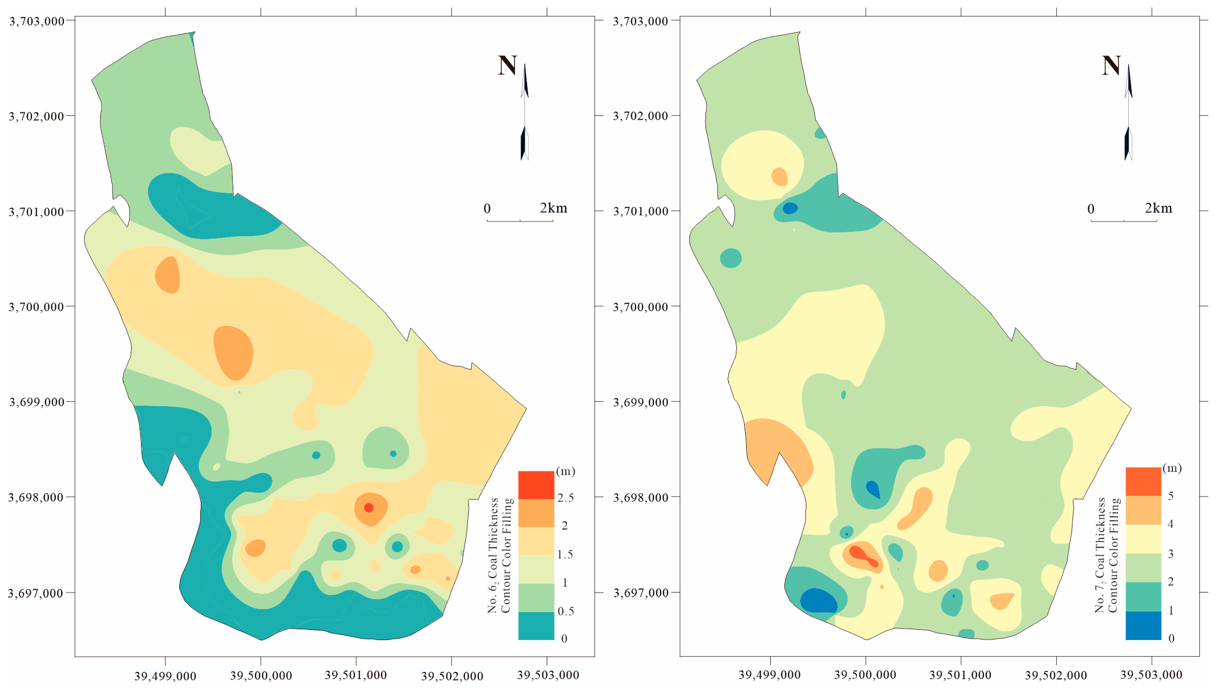
5. Analysis of the No. 7 Coal Pore-Rich Sandstone Layers and Their Connectivity Modes

The sequence stratigraphic background of the No. 7 coal connectivity layer in Qinan Coal Mine determined the development of the No. 7 coal pore-rich sandstone layer. Within the sequence stratigraphic background of the No. 7 coal connectivity layer, the backgrounds of a parasequence and between parasequences determined the connectivity modes of the No. 7 coal pore-rich sandstone layers.

5.1. Analysis of the No. 7 Coal Pore-Rich Sandstone Layer

The sandstone layers within the No. 7 coal connectivity layer in Qinan Coal Mine include the No. 7 coal capping sandstone layer with poor physical properties and the No. 7 coal pore-rich sandstone layer with good physical properties. Notably, the No. 7 coal pore-rich sandstone layer controlled the CBM escape within the No. 7 coal seam.
Through the analysis of the cast thin sections made of borehole samples in Qinan Coal Mine, and the parasequence types of the No. 7 coal connectivity layer mentioned above, it was found that the No. 7 coal capping sandstone layer with poor physical properties was formed in the sedimentary environment of the distributary channel edge. This sandstone exhibits poor sorting, poor roundness, and small or no pores (Figure 5, sample 1), without the ability to escape and store the CBM. Conversely, the No. 7 coal pore-rich sandstone layer with good physical properties was formed in the sedimentary environment of the estuary dam and distributary channel. This sandstone demonstrates good sorting, good roundness, and large and many pores (Figure 5, samples 2 and 3), with the ability to escape and store the CBM.

5.2. The Connectivity Modes of the No. 7 Coal Pore-Rich Sandstone Layers

The connectivity of the No. 7 coal pore-rich sandstone layers within the No. 7 coal connectivity layer in Qinan Coal Mine is the fundamental reason for the correlation between the escape of the No. 7 coal seam CBM and the total thickness of the No. 7 coal pore-rich sandstone layers. The analysis of the connectivity modes of the No. 7 coal pore-rich sandstone layers was carried out in the parasequence scale. The connectivity modes were divided into the small-scale connectivity modes of the pore-rich sandstone layers within a parasequence and the large-scale connectivity modes of the pore-rich sandstone layers between parasequences. The connectivity of the pore-rich sandstone layers within a parasequence in the No. 7 coal connectivity layer is the reason for the CBM escape to the pore-rich sandstone layers within a parasequence. It is also the basis of the correlation between the CBM escape and the total thickness of the pore-rich sandstone layers. The connectivity of the pore-rich sandstone layers between parasequences in the No. 7 coal connectivity layer is the cause of the CBM escape to the pore-rich sandstone layers of more than one parasequence. It is also the decisive factor of the correlation between the CBM escape and the total thickness of the pore-rich sandstone layers. According to the study of the connectivity modes of the pore-rich sandstone layers within a parasequence and between parasequences in the No. 7 coal connectivity layer, three connectivity modes were summarized for the No. 7 coal pore-rich sandstone layers in the region: vertical connectivity, lateral connectivity, and non-connectivity.
(1)
The connectivity modes of the pore-rich sandstone layers within a parasequence in the No. 7 coal connectivity layer
The connectivity of the pore-rich sandstone layers within a parasequence in the No. 7 coal connectivity layer was controlled by the background of a source supply and base level change in the parasequence. This connectivity refers to the connectivity of the pore-rich sandstone layers of microfacies in the estuary dam and distributary channel within a parasequence of the fluvial depositional cycle, and it can be classified into three modes. The first mode is vertical connectivity, meaning that there are only the pore-rich sandstone layers within a parasequence in the No. 7 coal connectivity layer, and there are no local capping layers. The CBM in the No. 7 coal seam can vertically escape through the pore-rich sandstone layers. The second mode is lateral connectivity, meaning that there is the presence of the local capping layers within a parasequence in the No. 7 coal connectivity layer. The vertical escape of the CBM in No. 7 coal seam was terminated, and the CBM started to laterally escape to the low-pressure zone in the pore-rich sandstone layers. The third mode is non-connectivity, meaning that there are only local capping layers within a parasequence in the No. 7 coal connectivity layer. The CBM in No. 7 coal seam basically cannot escape.
(2)
The connectivity modes of the pore-rich sandstone layers between parasequences in the No. 7 coal connectivity layer
The connectivity of the pore-rich sandstone layers between parasequences in the No. 7 coal connectivity layer was controlled by the sedimentary compensation relationship under the influence of a source supply and base level change. This connectivity is mainly manifested as the connectivity of the pore-rich sandstone layers of microfacies in the estuary dam and distributary channel between the parasequences. Specifically, there are three specific modes.
The first mode is vertical connectivity, which refers to the absence of the local capping layer at the top of the lower parasequence before the base level rise and the presence of the estuary dam or distributary channel sandstone layer at the bottom of the upper parasequence after the base level rise. The pore-rich sandstone layers between the parasequences are vertically connected, facilitating the vertical escape of the CBM. The sedimentary compensation relationship between the parasequences is undercompensation or overcompensation. The contact relationship between the parasequences is erosion or obvious contact. According to the conditions mentioned above, the vertical connectivity can be specifically classified into the following two situations: First, when the bottom of the upper sequence consists of estuary dam sandstone, it shows a strong sediment supply and a large base level rise caused by a basin subsidence. Because the conditions resulted in the dissipation of the fluvial erosion energy, no erosion occurred. The sedimentary compensation relationship between the parasequences is undercompensation, and the contact relationship between the parasequences is obvious contact. Second, when the bottom of the upper parasequence consists of distributary channel sandstone, it indicates a strong sediment supply and a somewhat large base level rise caused by a basin subsidence. Due to the presence of fluvial erosion energy, erosion between the parasequences occurred. The sedimentary compensation relationship between the parasequences is overcompensation, and the contact relationship between the parasequences is erosion contact. The first situation is more common than the second one in coal mines.
The second mode is lateral connectivity, which refers to the existence of the local capping layer at the top of the lower parasequence before the base level rise and the presence of the distributary channel sandstone layer at the bottom of the upper parasequence after the base level rise. The pore-rich sandstone layers between the parasequences are laterally connected, facilitating the lateral escape of the CBM. The sedimentary compensation relationship between the parasequences is overcompensation to isostatic compensation. The contact relationship between the parasequences is erosion or obvious contact. It shows the formation background in which the source supply was medium and the base level rise caused by basin subsidence was small or medium. The fluvial erosion energy was not unloaded or just unloaded.
The third mode is non-connectivity, which refers to the fact that the parasequences before and after the base level rise are a local capping layer. There are no pore-rich sandstone layers between the parasequences. Consequently, there is no CBM escape.
Based on the above analysis, taking the connectivity modes of the pore-rich sandstone layers within a parasequence in the No. 7 coal connectivity layer as the premise, and the connectivity modes of the pore-rich sandstone layers between parasequences in the No. 7 coal connectivity layer as the key, the connectivity modes of the No. 7 coal pore-rich sandstone layers were proposed and divided into three modes: vertical connectivity, lateral connectivity, and non-connectivity. The vertical connectivity mode of the pore-rich sandstone layers is the vertical connectivity mode between parasequences based on the vertical and lateral connectivity mode within a parasequence. This mode appears in a location within the research region where there are no local capping layers within the No. 7 coal connectivity layer, leading to the vertical escape of the CBM (Figure 6, Figure 7, and Figure 10). The lateral connectivity mode of the pore-rich sandstone layers is the lateral connectivity mode between parasequences based on the vertical and lateral connectivity mode within a parasequence. This mode occurs at a location within the research region where there are the local capping layers within the connectivity layer, resulting in the lateral escape of the CBM (Figure 6, Figure 7, Figure 9 and Figure 10). The non-connectivity mode of the pore-rich sandstone layers is the non-connectivity mode within a parasequence or between parasequences. This mode occurs at a location within the research region where there are no pore-rich sandstone layers and a local capping layer as a whole, or at a location where the pore-rich sandstone layers are unconnected, which made the CBM basically unable to escape (Figure 6, Figure 7, Figure 9 and Figure 10).

6. The Accumulation Model of the No. 7 Coal Seam CBM

Based on the key geological factors and CBM parameters of the No. 7 coal seam CBM, the Lower Shihezi formation in Qinan Coal Mine, the accumulation law in No. 7 coal seam CBM in the region was systematically analyzed. The models for sandstone layer connectivity and its control on CBM accumulation based on sequence stratigraphic analysis were proposed.

6.1. The Accumulation and Its Law of the No. 7 Coal Seam CBM

The key geological factors for the No. 7 coal seam CBM accumulation have the connectivity modes and the thickness of the pore-rich sandstone layers within the No. 7 coal seam. The parameters for the No. 7 coal seam CBM accumulation include the CBM content and the absolute CBM emission rate in coal lanes (include both machine lane and wind lane).

6.1.1. The Connectivity Modes of the No. 7 Coal Pore-Rich Sandstone Layers and CBM Accumulation

Based on the analysis (Figure 6, Figure 7, Figure 9 and Figure 10), the CBM content in vertically connected positions of the No. 7 coal pore-rich sandstone layers in the region is the lowest (Figure 10, such as X16# borehole), measuring less than 2 m3/t. In laterally connected positions, the CBM content is moderate, ranging from 2 to 4 m3/t (Figure 7, such as X13# borehole), and in corresponding coal lane position, the CBM emission rate is low, between 0.18 and 0.5 m3/min. In unconnected positions, the CBM content is highest, exceeding 4 m3/t and often surpassing 6 m3/t (Figure 9 and Figure 10), and in the corresponding coal lane positions, the CBM emission rate is high, ranging from 0.5 to 2.18 m3/min.
The overall performance shows that the vertically connected positions of the No. 7 coal pore-rich sandstone layers have the strongest CBM desorption and escape and the lowest CBM content; the laterally connected positions of the No. 7 coal pore-rich sandstone layers have moderate CBM desorption and escape and moderate CBM content; and the unconnected positions of the No. 7 coal pore-rich sandstone layers have the weakest CBM desorption and escape and the highest CBM content. Therefore, the connectivity modes of the No. 7 coal pore-rich sandstone layers in the research region are closely related to the CBM accumulation.

6.1.2. The Thickness of the No. 7 Coal Pore-Rich Sandstone Layers and CBM Accumulation

The analysis (Figure 8) reveals that the thickness center positions of the No. 7 coal pore-rich sandstone layers in the region exhibit the thickest total thickness, exceeding 10 m. The positions have the lowest CBM content, measuring below 2 m3/t. In the vicinity of the center position, where the total thickness of the No. 7 coal pore-rich sandstone layers is thinning, it ranges from 5 to 10 m. The CBM content in the region is moderate, ranging from 2 to 4 m3/t, and corresponds to a relatively low CBM emission rate, ranging from 0.18 to 0.5 m3/min. In the thinnest positions of the No. 7 coal pore-rich sandstone layers, which are at the center of the local capping layers, the total thickness of the No. 7 coal pore-rich sandstone layers ranges from 0 to 5 meters. The positions exhibit the highest CBM content, exceeding 4 m3/t, with the majority surpassing 6 m3/t, and the corresponding CBM emission rate is high, ranging from 0.5 to 2.18 m3/min.
The contour lines of thickness of the No. 7 coal pore-rich sandstone layers are consistent with the laws of CBM content and the emission rate (Figure 8). The overall performance shows that the thicker the No. 7 coal pore-rich sandstone layers, the stronger the CBM escape, leading to a lower CBM content. At positions without the No. 7 coal pore-rich sandstone layers, the closer the distance to the thickness center of the layers, the more the CBM escapes, resulting in a decrease in CBM content. Therefore, the thickness of the No. 7 coal pore-rich sandstone layers in the region is closely related to the No. 7 coal seam CBM accumulation.

6.1.3. The Accumulation Law of the No. 7 Coal Seam CBM

The above analysis found that the vertically connected positions and the thickness center positions of the No. 7 coal pore-rich sandstone layers are overlapped, the laterally connected positions and the thickness thinning positions of the No. 7 coal pore-rich sandstone layers are overlapped, and the unconnected positions and the thinnest positions of the No. 7 coal pore-rich sandstone layers are overlapped. These three features are clearly shown in Figure 6, Figure 7, Figure 8, Figure 9 and Figure 10. Therefore, it was determined that the connectivity modes and the thickness of the No. 7 coal pore-rich sandstone layers jointly controlled the CBM accumulation of the No. 7 coal seam in Qinan Coal Mine. The accumulation law of CBM in the No. 7 coal seam is as follows: First, in the thickest positions of vertical connectivity in the pore-rich sandstone layers, CBM desorption and escape are strong, resulting in low CBM. Second, in the thinning positions of lateral connectivity in the pore-rich sandstone layers, CBM desorption and escape were moderate, leading to moderate CBM. Third, in the thinnest positions of non-connectivity in the pore-rich sandstone layers, CBM desorption and escape are weak to non-existent, resulting in high CBM. Specifically, in the positions near the center of the thickness of the pore-rich sandstone layers, there is a little CBM escape, resulting in lower CBM, and in the positions far away from the center of the thickness of the pore-rich sandstone layers, there is no CBM escape, leading to higher CBM.

6.2. The Models for Sandstone Layer Connectivity and Its Control on CBM Accumulation Based on Sequence Stratigraphic Analysis

The models for sandstone layer connectivity and its control on CBM accumulation based on sequence stratigraphic analysis refer to the models of CBM accumulation regulated by the interconnectivity of the sandstone layers. The interconnectivity is controlled by the background of a source supply and base level change. The background corresponds to an intensity of source supply, basin subsidence degree, and sedimentary compensation relationship within a parasequence and between parasequences. Based on these factors, three models of CBM accumulation have been identified: the weak CBM accumulation model under conditions of strong source supply, large basin subsidence, and undercompensation deposition; the moderate CBM accumulation model under conditions of moderate source supply, moderate basin subsidence, and overcompensation to isostatic compensation deposition; and the strong CBM accumulation model under conditions of weak source supply, small basin subsidence, and undercompensation deposition. The three models represent the models of CBM accumulation of the No. 7 coal seam of the Lower Shihezi Formation in Qinan Coal Mine (Figure 11).
(1)
The weak CBM accumulation model with a strong source supply, large basin subsidence, and undercompensation deposition
The model occurs at a location within a research region that is close to the source. This position is characterized by a strong source supply and a large base level rise, which is caused by a large basin subsidence. Its sedimentary compensation relationship is undercompensation, with no erosion contact between parasequences. The total thickness of overlying pore-rich sandstone layers is the thickest, and the connectivity mode of these layers is vertical without the local capping layers. This leads to the strongest CBM desorption and escape.
The model represents the No. 7 coal CBM accumulation partition (I) (Figure 11) in Qinan Coal Mine. The lower part of the No. 7 coal connectivity layer exhibits parasequence types 1 and 2, while the upper part displays parasequence types 3 to 8. The total thickness of the pore-rich sandstone layers within the connectivity layer is the thickest in the research region, exceeding 10 m. Occasionally, the capping sandstone layers can be found within the connectivity layer, with no development of siltstone and mudstone. The No. 7 coal CBM desorption and escape are the strongest, with CBM content below 2 m3/t, representing the lowest value in the research region (X9# borehole as in Figure 7).
(2)
The moderate CBM accumulation model with a moderate source supply, medium basin subsidence, and overcompensation to isostatic compensation deposition
The model appears in a location within a research region that is a moderate distance from the source. This position is characterized by a moderate source supply and a moderate base level rise, which is caused by a moderate basin subsidence. Its sedimentary compensation relationship is overcompensation to isostatic compensation, with erosion contact between parasequences. The total thickness of overlying pore-rich sandstone layers is moderate, and the connectivity mode of these layers is lateral with the local capping layers. This leads to moderate CBM desorption and escape.
The model represents the No. 7 coal CBM accumulation partition (Ⅱ) (Figure 11) in Qinan Coal Mine. In the lower part of the No. 7 coal connectivity layer, parasequence types 3 to 8 are developed, while in the upper part, parasequence types 7 to 10 are developed. The total thickness of the pore-rich sandstone layers within the connectivity layer is moderate in the research region, ranging from 5 to 10 m. The connectivity layer contains a significant amount of siltstone and mudstone. The No. 7 coal CBM desorption and escape are moderate, with CBM content ranging from 2 to 4 m3/t and CBM emission rate between 0.18 and 0.5 m3/min, representing the moderate level in the research region (X13# borehole as in Figure 7).
(3)
The strong CBM accumulation model with a weak source supply, small basin subsidence, and undercompensation deposition
The model occurs at a location within a research region that is far away from the source. It is characterized by a weak source supply and a small base level rise, which is caused by a small basin subsidence. Its sedimentary compensation relationship is undercompensation, with fine-grained sediments present within a parasequence and no erosion contact between parasequences. The total thickness of the overlying pore-rich sandstone layers is the thinnest or absent, and the connectivity mode of these layers is non-connective. This results in the weakest CBM desorption and escape.
The model includes the No. 7 coal CBM accumulation partition (III) and (IV) (Figure 11) in Qinan Coal Mine. In the lower part of the No. 7 coal connectivity layer, parasequence types 3, 7, and 9 are developed, while in the upper part, parasequence types 8 and 10 are developed. The total thickness of the pore-rich sandstone layers within the connectivity layer is the thinnest in the research region, ranging from 0 to 5 meters. The connectivity layer consists of siltstone and mudstone entirely, resulting in the weakest CBM desorption and escape and the highest CBM value. In addition, the No. 7 coal CBM accumulation partition (IV) far away from the center of the pore-rich sandstone layers has a higher CBM content than the No. 7 coal CBM accumulation partition (III) close to the center. The CBM content of the No. 7 coal CBM accumulation partition (III) ranges from 4 to 10 m3/t, and the CBM emission rate ranges from 0.5 to 1.5 m3/min (X26# borehole as in Figure 9). The CBM content of the No. 7 coal CBM accumulation partition (IV) is more than 10 m3/t, and the CBM emission rate is more than 1.5 m3/min (X24# borehole as in Figure 9).

7. Conclusions

In this paper, sandstone layer connectivity and its control on CBM accumulation based on sequence stratigraphic analysis were analyzed, taking the example of the No. 7 coal seam CBM unit of the Lower Shihezi Formation in Qinan Mine, Xuzhou–Suzhou Region, China. The following conclusions were obtained:
(1)
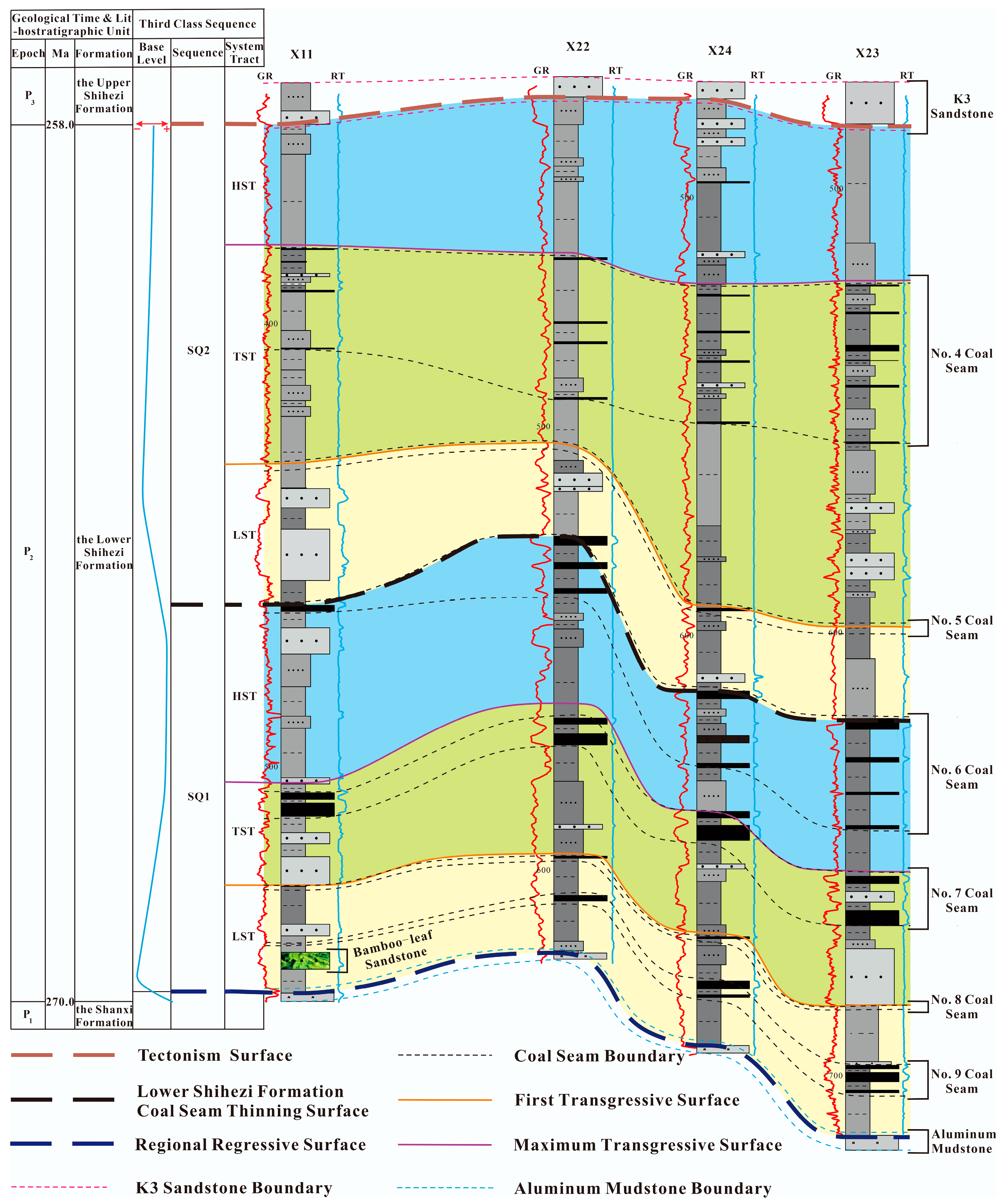
The sequence stratigraphic surfaces of the Lower Shihezi Formation in Qinan Coal Mine include the regional regressive surface, the tectonism surface, and the Lower Shihezi Formation coal seam thinning surface. The sequence stratigraphic framework comprises two third-class sequences, SQ1 and SQ2, as well as six system tracts. SQ1 is the lower portion of the Lower Shihezi Formation, and SQ2 is the upper portion of the Lower Shihezi Formation.
(2)
The formation of the No. 7 coal seam CBM unit is controlled by the sequence stratigraphic background. The CBM unit includes the No. 7 coal CBM formation layer in the SQ1 transgressive system tract and the No. 7 coal connectivity layer and the No. 7 coal stable capping layer in the SQ1 highstand system tract. The No. 7 coal CBM formation layer corresponds to the Q1 parasequence. The No. 7 coal connectivity layer comprises the Q2, Q3, Q4, and Q5 parasequences. The No. 7 coal stable capping layer corresponds to the Q6 parasequence.
(3)
The No. 7 coal connectivity layer consists of ten types of parasequences. The parasequence stratigraphic background determines the formation of pore-rich sandstone within the estuary dam and distributary channel microfacies in the connectivity layer, and it also dictates the connectivity modes of the pore-rich sandstone layers in the connectivity layer. The connectivity modes include vertical connectivity, lateral connectivity, and non-connectivity.
(4)
The connectivity modes and the thickness of the No. 7 coal pore-rich sandstone layers combined to control the No. 7 coal seam CBM accumulation in Qinan Coal Mine. The accumulation law of CBM in the No. 7 coal seam is as follows: First, in the thickest positions of vertical connectivity in the pore-rich sandstone layers, CBM desorption and escape were strong, resulting in low CBM. Second, in the thinning positions of lateral connectivity in the pore-rich sandstone layers, CBM desorption and escape were moderate, leading to moderate CBM. Third, in the thinnest positions of non-connectivity in the pore-rich sandstone layers, CBM desorption and escape were weak to non-existent, resulting in high CBM. Specifically, in the positions near the center of the thickness of the pore-rich sandstone layers, there was a little CBM escape, resulting in lower CBM. In the positions far away from the center of the thickness of the pore-rich sandstone layers, there was no CBM escape, leading to higher CBM.
(5)
The models for sandstone layer connectivity and its control on CBM accumulation based on sequence stratigraphic analysis include: (1) the weak CBM accumulation model, characterized by a strong source supply, large basin subsidence, and undercompensation deposition; (2) the moderate CBM accumulation model, characterized by a moderate source supply, moderate basin subsidence, and overcompensation to isostatic compensation deposition; and (3) the strong CBM accumulation model, characterized by a weak source supply, small basin subsidence, and undercompensation deposition.
The innovations of this paper are as follows: updating the sequence stratigraphic framework and evolution understanding of the Lower Shihezi Formation in Qinan Coal Mine in the Xuzhou–Suzhou Region, China; proposing, for the first time, models for sandstone layer connectivity and its control on CBM accumulation based on sequence stratigraphic analysis.

Author Contributions

Investigation, W.W., W.H., J.L. and S.D.; data curation, C.L.; writing—original draft preparation, K.W.; writing—review and editing, K.W. and Z.Q.; visualization, W.W. and Q.Z. All authors have read and agreed to the published version of the manuscript.

Funding

This study was supported by the Jiangsu Province Carbon Peak Carbon Neutral Technology Innovation Project in China (Grant No. BE2022034), and Huaibei Mining Group Scientific Research Project (Grant No. 202273).

Data Availability Statement

Data are contained within the article.

Acknowledgments

We sincerely thank the reviewers for their valuable suggestions and comments, which greatly contributed to improving the manuscript.

Conflicts of Interest

The authors declare no conflicts of interest.

References

  1. Li, H.; Cao, Y.; Qin, Y.; Quan, J.; Li, D.; Wang, Z. Characteristics of coalbed methane endowment and geological control factors in Chongqing coal mining area. Coalf. Geol. Explor. 2015, 43, 1–7, 12. [Google Scholar]
  2. Liu, H. Research on the Coalbed Methane Storage Law and Geological Control of 8_1~# Coal in Yangquan Wenjiazhuang Mine. Master’s Thesis, China University of Mining and Technology, Xuzhou, China, 2016. [Google Scholar]
  3. Qin, Y.; Fu, X.; Yue, W.; Lin, D.; Ye, J.; Jiao, S. Relationship between sedimentary system and coalbed methane reservoir and cover characteristics. J. Paleogeography 2000, 1, 77–84. [Google Scholar]
  4. Xie, J. Analysis of coalbed methane geological law and its controlling factors in Jialequan coal mine of Xishan Coalfield. Energy Technol. Manag. 2019, 44, 22–23, 106. [Google Scholar]
  5. Zhang, L. Status and problems of coal mine coalbed methane prevention and control technology. China Sci. Technol. Inf. 2020, 17, 2. [Google Scholar]
  6. Beamish, B.B.; Crosdale, P.J. Instantaneous outbursts in underground coal mines: An overview and association with coal type. Int. J. Coal Geol. 1998, 35, 27–55. [Google Scholar] [CrossRef]
  7. Petrosian, A.E. Coal Mine Methane Gas Emergence; Coal Industry Press: Beijing, China, 1983. [Google Scholar]
  8. Wang, Y. Research on the Stratigraphy of Taiyuan Group and Coalbed Methane Storage Law in Yangquan Sijiazhuang Mine. Master’s Thesis, China University of Mining and Technology, Xuzhou, China, 2017. [Google Scholar]
  9. Sun, Y. Depositional Environment of Shanxi Formation in Gujiao Mining Area and Its Influence on Coalbed Methane Enrichment. Master’s Thesis, China University of Mining and Technology, Xuzhou, China, 2015. [Google Scholar]
  10. Lin, Y.; Qin, Y.; Wang, W.; Han, D. Characteristics of coalbed methane storage and its geological control in Hujiahe Coal Mine, Binchang Mining Area. Coal Mine Saf. 2019, 50, 219–223. [Google Scholar] [CrossRef]
  11. Sun, B.; Li, X.; Fan, F. Precise detection technology of the unloading coalbed methane storage characteristics in thick coal seams with strong mining overburden. Coal Mine Saf. 2022, 53, 75–82. [Google Scholar] [CrossRef]
  12. Wang, L.; Zheng, S.; Zhao, W.; Chen, D.; Zhu, Z. Study on the variability and control factors of coal and CBM protrusion disasters in Huaibei Coalfield. Coal Sci. Technol. 2020, 48, 9. [Google Scholar]
  13. Shangguan, M. Research on the Geologic Pattern of Coalbed Methane and Coalbed Methane Prediction in Wugou Coal Mine. Master’s Thesis, Henan University of Science and Technology, Luoyang, China, 2010. [Google Scholar]
  14. Liu, W.; Xu, L.; He, Z. Sedimentary environment analysis of Permian coal-bearing strata in Huaibei Zhahe mining area. China Coalf. Geol. 1996, 3, 19–21. [Google Scholar]
  15. Ma, S.; Wang, Y.; Wang, X.; Chen, S.; Jing, A.; Tian, W.; Xin, Y. Carboniferous-Permian sedimentary infilling process in eastern North China and its response to tectonic evolution of the source area. Oil Gas Geol. Recovery 2023, 30, 1–20. [Google Scholar]
  16. Li, K.; Li, W.; Yu, Z.; Liang, J. Temporal and spatial coupling of source-sink systems in the Permian Box 8 of the Ordos Basin. J. Northwest Univ. Nat. Sci. Ed. 2020, 50, 10. [Google Scholar] [CrossRef]
  17. Wu, W.; Liu, W.; Chen, K. Analysis of Permian sedimentary environment in Huaibei Coalfield. Beijing Geol. 2000, 3, 21–25. [Google Scholar]
  18. Yu, H.; Lu, F.; Guo, Q.; Lu, W.; Wu, J.; Han, S. Typology and tectonic evolution of the prototypical sedimentary basin at the southern margin of the North China Craton. Exp. Geol. Pet. 2005, 2, 111–117. [Google Scholar]
  19. Ma, Y. Tectonic Evolution of the Huanghua Depression in the Bohai Bay Basin and Its Control on the Oil and Gas Formation Conditions in the Carboniferous-Permian Subduction Zone. Master’s Thesis, Northeast Petroleum University, Daqing, China, 2020. [Google Scholar]
  20. Li, R. Tectonic characterization of the Zhanhua Depression in the Bohai Bay Basin. Master’s Thesis, Chengdu University of Technology, Chengdu, China, 2018. [Google Scholar]
  21. Zhang, G.; Zhang, Z.; Dong, Y. Tectonic properties of major tectonic rock stratigraphic units in the Qinling orogenic belt and their geotectonic significance. J. Petrol. 1995, 2, 101–114. [Google Scholar]
  22. Mitchum, R.M.; Vail, P.V.; Sangree, J.B. Stratigraphic interpretation of seismic reflection patterns in depositional sequences. AAPG Mem. 1977, 26, 117–133. [Google Scholar]
  23. Shao, L.; Dong, D.; Li, M.; Wang, H.; Wang, D.; Lu, J.; Zheng, M.; Cheng, A. Carboniferous-Permian stratigraphy-paleogeography and coal gathering pattern in North China. J. Coal 2014, 10. [Google Scholar] [CrossRef]
  24. Zhang, S.; Chen, J.; Zhang, B.; Sha, J.; Zeng, J.; Liu, W.; Chen, P.; Wang, X.; Liu, Q.; Zhang, P. Geochemical characteristics of aluminum mudstone in the coal beds of the Huainan Coal Field, Anhui Province, China. China Coal Geol. 2020, 32, 7. [Google Scholar] [CrossRef]
  25. Ji, Y.; Zhou, Y. Sequence Stratigraphy; China Petrochemical Press: Beijing, China, 2020. [Google Scholar]
  26. Zhang, W.; Lu, J.; Li, Y.; Wang, J.; Shao, L. Stratigraphy of Carboniferous-Permian coal-bearing rock systems and coal aggregation characteristics in Southwest of Shandong. J. Paleogeography 2010, 12, 90–96. [Google Scholar]
  27. Cheng, G. Research on the Structural Characteristics of Ductile Deformation Series Tectonic Coal and Its Coalbed Methane Properties. Master’s Thesis, China University of Mining and Technology, Xuzhou, China, 2017. [Google Scholar]
Figure 1. Location map of the research region (adapted from [15]).
Energies 17 00634 g001
Figure 2. Sequence stratigraphic surface and framework map of the Lower Shihezi Formation in Qinan Coal Mine, Xuzhou–Suzhou Region.
Energies 17 00634 g002
Figure 3. The representative rocks near the regional regressive surface ((a)—containing Iron oolitic aluminum mudstone; (b)—bamboo-leaf sandstone).
Energies 17 00634 g003
Figure 4. Contour map of the No. 62 coal seam (left) and No. 72 coal seam (right) thickness in Qinan Coal Mine.
Energies 17 00634 g004
Figure 5. Composite columnar diagram of X16# borehole in the research region (in the microfacies, “a” is estuary dam microfacies, “b” is distributary channel microfacies, “c” is distributary channel edge microfacies, “d” is interdistributary bay microfacies, and “e” is peat swamp microfacies).
Energies 17 00634 g005
Figure 9. Parasequence analysis profile 3 of the No. 7 coal connectivity layer (the locations of boreholes are shown in Figure 8 Well Profile Line 3).
Energies 17 00634 g009
Figure 10. Parasequence analysis profile 4 of the No. 7 coal connectivity layer (the locations of boreholes are shown in Figure 8 Well Profile Line 4).
Energies 17 00634 g010
Figure 11. CBM accumulation model partition map of the No. 7 coal seam in Qinan Coal Mine, Xuzhou–Suzhou Region.
Energies 17 00634 g011
Disclaimer/Publisher’s Note: The statements, opinions and data contained in all publications are solely those of the individual author(s) and contributor(s) and not of MDPI and/or the editor(s). MDPI and/or the editor(s) disclaim responsibility for any injury to people or property resulting from any ideas, methods, instructions or products referred to in the content.

