
Contrasts in Top Soil Infiltration Processes for Degraded vs. Restored Lands. A Case Study at the Perijá Range in Colombia

 , , , , and
Abstract
:1. Introduction
2. Materials and Methods
2.1. Study Area
2.2. Field Measurements
2.2.1. Vegetation Sampling
2.2.2. Saturated Hydraulic Conductivity
2.2.3. Dye Tracer Experiments
2.3. Data Analyses
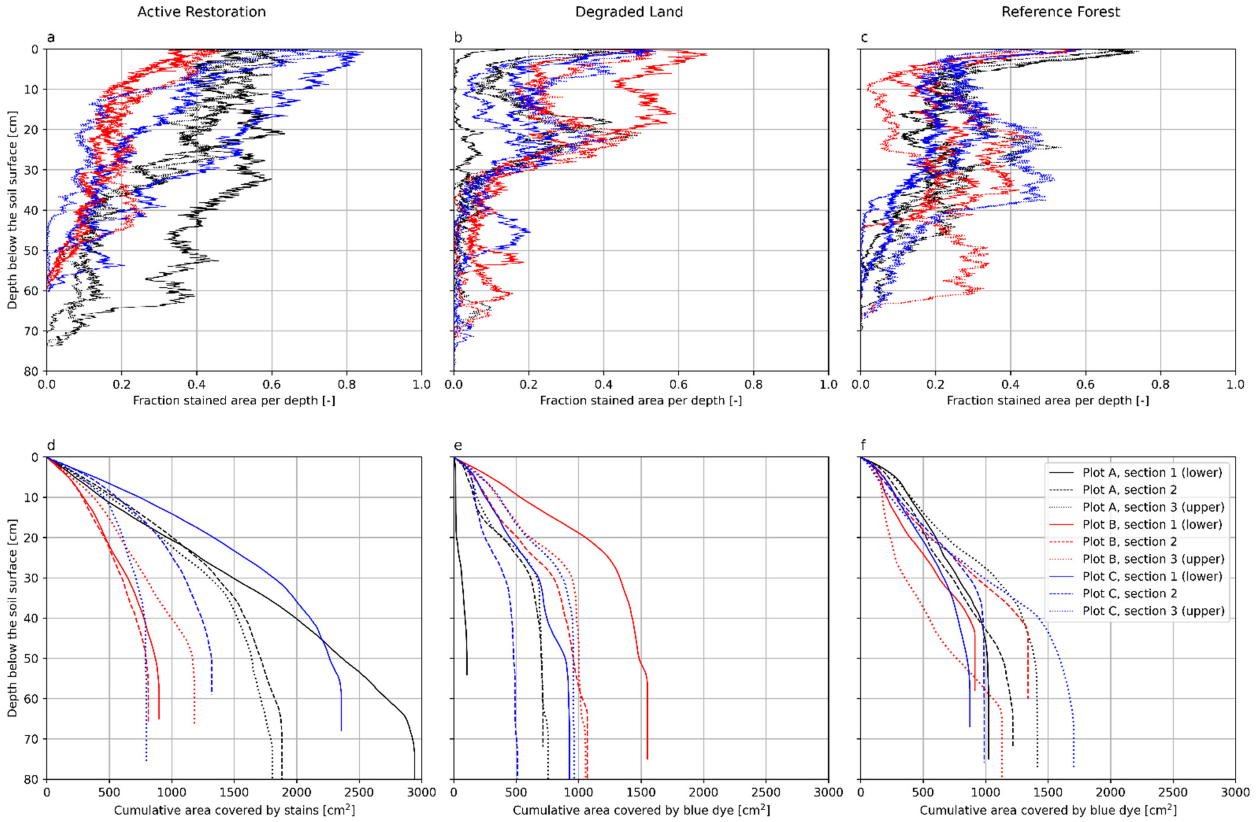
3. Results
4. Discussion
4.1. Space for Time Approach Not Applicable
4.2. Topsoil Properties and Vegetation Characteristics
4.3. Infiltration Characteristics and Implications for Runoff Processes
5. Conclusions
Supplementary Materials
Author Contributions
Funding
Institutional Review Board Statement
Informed Consent Statement
Acknowledgments
Conflicts of Interest
References
- Chazdon, R.L.; Brancalion, P.H.S.; Lamb, D.; Laestadius, L.; Calmon, M.; Kumar, C. A Policy-Driven Knowledge Agenda for Global Forest and Landscape Restoration: A Policy-Driven Agenda for Restoration. Conserv. Lett. 2017, 10, 125–132. [Google Scholar] [CrossRef]
- Brancalion, P.H.S.; Niamir, A.; Broadbent, E.; Crouzeilles, R.; Barros, F.S.M.; Zambrano, A.M.A.; Baccini, A.; Aronson, J.; Goetz, S.; Reid, J.L.; et al. Global restoration opportunities in tropical rainforest landscapes. Sci. Adv. 2019, 5, eaav3223. [Google Scholar] [CrossRef] [PubMed] [Green Version]
- Filoso, S.; Bezerra, M.O.; Weiss, K.C.B.; Palmer, M.A. Impacts of forest restoration on water yield: A systematic review. PLoS ONE 2017, 12, e0183210. [Google Scholar] [CrossRef] [PubMed] [Green Version]
- Strassburg, B.B.N.; Iribarrem, A.; Beyer, H.L.; Cordeiro, C.L.; Crouzeilles, R.; Jakovac, C.C.; Junqueira, A.B.; Lacerda, E.; Latawiec, A.E.; Balmford, A.; et al. Global priority areas for ecosystem restoration. Nature 2020, 586, 724–729. [Google Scholar] [CrossRef] [PubMed]
- Brancalion, P.H.S.; Holl, K.D. Guidance for successful tree planting initiatives. J. Appl. Ecol. 2020, 57, 2349–2361. [Google Scholar] [CrossRef]
- Gatica-Saavedra, P.; Echeverría, C.; Nelson, C.R. Ecological indicators for assessing ecological success of forest restoration: A world review: Indicators for Forest Restoration. Restor. Ecol. 2017, 25, 850–857. [Google Scholar] [CrossRef]
- Lozano-Baez, S.E.; Cooper, M.; Meli, P.; Ferraz, S.F.; Rodrigues, R.R.; Sauer, T.J. Land restoration by tree planting in the tropics and subtropics improves soil infiltration, but some critical gaps still hinder conclusive results. For. Ecol. Manag. 2019, 444, 89–95. [Google Scholar] [CrossRef]
- Pereira, N.A.; Di Prima, S.; Bovi, R.C.; Da Silva, L.F.S.; De Godoy, G.; Naves, R.P.; Cooper, M. Does the Process of Passive Forest Restoration Affect the Hydrophysical Attributes of the Soil Superficial Horizon? Water 2020, 12, 1689. [Google Scholar] [CrossRef]
- Sun, D.; Yang, H.; Guan, D.; Yang, M.; Wu, J.; Yuan, F.; Jin, C.; Wang, A.; Zhang, Y. The effects of land use change on soil infiltration capacity in China: A meta-analysis. Sci. Total Environ. 2018, 626, 1394–1401. [Google Scholar] [CrossRef]
- Kardol, P.; Wardle, D. How understanding aboveground–belowground linkages can assist restoration ecology. Trends Ecol. Evol. 2010, 25, 670–679. [Google Scholar] [CrossRef]
- Ohsowski, B.M.; Klironomos, J.N.; Dunfield, K.E.; Hart, M.M. The potential of soil amendments for restoring severely disturbed grasslands. Appl. Soil Ecol. 2012, 60, 77–83. [Google Scholar] [CrossRef]
- Mukul, S.A.; Herbohn, J.; Firn, J. Co-benefits of biodiversity and carbon sequestration from regenerating secondary forests in the Philippine uplands: Implications for forest landscape restoration. Biotropica 2016, 48, 882–889. [Google Scholar] [CrossRef]
- Barral, M.P.; Benayas, J.M.R.; Meli, P.; Maceira, N.O. Quantifying the impacts of ecological restoration on biodiversity and ecosystem services in agroecosystems: A global meta-analysis. Agric. Ecosyst. Environ. 2015, 202, 223–231. [Google Scholar] [CrossRef] [Green Version]
- Ziegler, A.D.; Giambelluca, T.W.; Tran, L.T.; Vana, T.T.; Nullet, M.A.; Fox, J.; Vien, T.D.; Pinthong, J.; Maxwell, J.; Evett, S. Hydrological consequences of landscape fragmentation in mountainous northern Vietnam: Evidence of accelerated overland flow generation. J. Hydrol. 2004, 287, 124–146. [Google Scholar] [CrossRef]
- Ilstedt, U.; Malmer, A.; Verbeeten, E.; Murdiyarso, D. The effect of afforestation on water infiltration in the tropics: A systematic review and meta-analysis. For. Ecol. Manag. 2007, 251, 45–51. [Google Scholar] [CrossRef]
- Bonnesoeur, V.; Locatelli, B.; Guariguata, M.R.; Ochoa-Tocachi, B.F.; Vanacker, V.; Mao, Z.; Stokes, A.; Mathez-Stiefel, S.-L. Impacts of forests and forestation on hydrological services in the Andes: A systematic review. For. Ecol. Manag. 2019, 433, 569–584. [Google Scholar] [CrossRef] [Green Version]
- Lozano-Baez, S.E.; Cooper, M.; Ferraz, S.F.B.; Rodrigues, R.R.; Pirastru, M.; Di Prima, S. Previous Land Use Affects the Recovery of Soil Hydraulic Properties after Forest Restoration. Water 2018, 10, 453. [Google Scholar] [CrossRef] [Green Version]
- Lozano-Baez, S.E.; Cooper, M.; Ferraz, S.F.D.B.; Rodrigues, R.R.; Castellini, M.; Di Prima, S. Recovery of Soil Hydraulic Properties for Assisted Passive and Active Restoration: Assessing Historical Land Use and Forest Structure. Water 2019, 11, 86. [Google Scholar] [CrossRef] [Green Version]
- Zimmermann, B.; Elsenbeer, H.; De Moraes, J.M. The influence of land-use changes on soil hydraulic properties: Implications for runoff generation. For. Ecol. Manag. 2006, 222, 29–38. [Google Scholar] [CrossRef]
- Bonell, M.; Purandara, B.; Venkatesh, B.; Krishnaswamy, J.; Acharya, H.; Singh, U.; Jayakumar, R.; Chappell, N. The impact of forest use and reforestation on soil hydraulic conductivity in the Western Ghats of India: Implications for surface and sub-surface hydrology. J. Hydrol. 2010, 391, 47–62. [Google Scholar] [CrossRef]
- Leite, P.A.; De Souza, E.S.; Dos Santos, E.S.; Gomes, R.J.; Cantalice, J.R.; Wilcox, B. The influence of forest regrowth on soil hydraulic properties and erosion in a semiarid region of Brazil. Ecohydrology 2017, 11, e1910. [Google Scholar] [CrossRef]
- Zwartendijk, B.; van Meerveld, H.; Ghimire, C.; Bruijnzeel, L.; Ravelona, M.; Jones, J. Rebuilding soil hydrological functioning after swidden agriculture in eastern Madagascar. Agric. Ecosyst. Environ. 2017, 239, 101–111. [Google Scholar] [CrossRef] [Green Version]
- Zwartendijk, B.; van Meerveld, H.; Ghimire, C.; Ravelona, M.; Lahitiana, J.; Bruijnzeel, L. Soil water- and overland flow dynamics in a tropical catchment subject to long-term slash-and-burn agriculture. J. Hydrol. 2020, 582, 124287. [Google Scholar] [CrossRef]
- van Meerveld, H.J.; Jones, J.P.G.; Ghimire, C.P.; Zwartendijk, B.W.; Lahitiana, J.; Ravelona, M.; Mulligan, M. Forest regeneration can positively contribute to local hydrological ecosystem services: Implications for forest landscape restoration. J. Appl. Ecol. 2021, 58, 755–765. [Google Scholar] [CrossRef]
- Saputra, D.D.; Sari, R.R.; Hairiah, K.; Roshetko, J.M.; Suprayogo, D.; Van Noordwijk, M. Can cocoa agroforestry restore degraded soil structure following conversion from forest to agricultural use? Agrofor. Syst. 2020, 94, 2261–2276. [Google Scholar] [CrossRef]
- Jačka, L.; Walmsley, A.; Kovář, M.; Frouz, J. Effects of different tree species on infiltration and preferential flow in soils developing at a clayey spoil heap. Geoderma 2021, 403, 115372. [Google Scholar] [CrossRef]
- Flury, M.; Wai, N.N. Dyes as tracers for vadose zone hydrology. Rev. Geophys. 2003, 41, 1002. [Google Scholar] [CrossRef]
- Kodešová, R.; Němeček, K.; Kodeš, V.; Žigová, A. Using Dye Tracer for Visualization of Preferential Flow at Macro- and Microscales. Vadose Zone J. 2012, 11, vzj2011.0088. [Google Scholar] [CrossRef]
- Etter, A.; Andrade, A.; Nelson, C.R.; Cortés, J.; Saavedra, K. Assessing restoration priorities for high-risk ecosystems: An application of the IUCN Red List of Ecosystems. Land Use Policy 2020, 99, 104874. [Google Scholar] [CrossRef]
- Etter, A.; McAlpine, C.; Possingham, H. Historical Patterns and Drivers of Landscape Change in Colombia Since 1500: A Regionalized Spatial Approach. Ann. Assoc. Am. Geogr. 2008, 98, 2–23. [Google Scholar] [CrossRef]
- Aguilar, M.; Sierra, J.; Ramirez, W.; Vargas, O.; Calle, Z.; Vargas, W.; Murcia, C.; Aronson, J.; Cataño, J.I.B. Toward a post-conflict Colombia: Restoring to the future. Restor. Ecol. 2015, 23, 4–6. [Google Scholar] [CrossRef]
- Lozano-Baez, S.E.; Domínguez-Haydar, Y.; Meli, P.; Meerveld, I.; Vásquez, K.V.; Castellini, M. Key gaps in soil monitoring during forest restoration in Colombia. Restor. Ecol. 2021, 29, 13391. [Google Scholar] [CrossRef]
- Lozano-Baez, S.; Domínguez-Haydar, Y.; Di Prima, S.; Cooper, M.; Castellini, M. Shade-Grown Coffee in Colombia Benefits Soil Hydraulic Conductivity. Sustainability 2021, 13, 7768. [Google Scholar] [CrossRef]
- Rangel-Ch, J.O. Integrated climate of the Perijá massif, Colombia. In Colombia Diversidad Biótica XVIII: Biodiversidad y Territorio de la Serranía de Perijá (Cesar-Colombia); Universidad Nacional de Colombia: Bogotá, Colombia, 2019; pp. 92–128. [Google Scholar]
- USDA-Natural Resources Conservation Service. Soil Survey Staff. In Keys to Soil Taxonomy, 12th ed.; USDA-Natural Resources Conservation Service: Washington, DC, USA, 2014. [Google Scholar]
- Rangel-Ch, J.O.; Carvajal-Cogollo, J.E.; Arellano-P, H. Suelos de la Serranía de Perijá. In Colombia Diversidad Biótica XVIII: Media y Baja Montaña de la Serranía de Perijá; Rangel-Ch, J.O., Ed.; Universidad Nacional de Colombia: Bogotá, Colombia, 2010; pp. 51–72. [Google Scholar]
- Nikhil, P. Canopy Capture a Smarter Way to Measure Canopy Cover. Available online: https://nikp29.github.io/CanopyCapture/ (accessed on 9 July 2021).
- Lassabatère, L.; Angulo-Jaramillo, R.; Ugalde, J.M.S.; Cuenca, R.; Braud, I.; Haverkamp, R. Beerkan Estimation of Soil Transfer Parameters through Infiltration Experiments-BEST. Soil Sci. Soc. Am. J. 2006, 70, 521–532. [Google Scholar] [CrossRef]
- Bagarello, V.; Di Prima, S.; Iovino, M. Estimating saturated soil hydraulic conductivity by the near steady-state phase of a Beerkan infiltration test. Geoderma 2017, 303, 70–77. [Google Scholar] [CrossRef]
- Di Prima, S.; Concialdi, P.; Lassabatere, L.; Angulo-Jaramillo, R.; Pirastru, M.; Cerdà, A.; Keesstra, S. Laboratory testing of Beerkan infiltration experiments for assessing the role of soil sealing on water infiltration. Catena 2018, 167, 373–384. [Google Scholar] [CrossRef]
- Beven, K.; Germann, P. Macropores and water flow in soils. Water Resour. Res. 1982, 18, 1311–1325. [Google Scholar] [CrossRef] [Green Version]
- Ghimire, C.P.; Zwartendijk, B.W.; Pde, F.; Bruijnzeel, L.A. Changes in Soil Hydraulic Conductivity and Preferential Flow Pathways after Assisted Forest Restoration on Degraded Land in the Khasi Hills (Meghalaya, NE India). In Proceedings of the EGU General Assembly 2021, online, 19–30 April 2021. EGU21-6559. [Google Scholar] [CrossRef]
- Weiler, M.; Flühler, H. Inferring flow types from dye patterns in macroporous soils. Geoderma 2004, 120, 137–153. [Google Scholar] [CrossRef]
- R Core Team. R: A Language and Environment for Statistical Computing; R Foundation for Statistical Computing: Viena, Austria, 2021. [Google Scholar]
- Virtanen, P.; Gommers, R.; Oliphant, T.E.; Haberland, M.; Reddy, T.; Cournapeau, D.; Burovski, E.; Peterson, P.; Weckesser, W.; Bright, J.; et al. SciPy 1.0: Fundamental algorithms for scientific computing in Python. Nat. Methods 2020, 17, 261–272. [Google Scholar] [CrossRef] [Green Version]
- Harris, C.R.; Millman, K.J.; van der Walt, S.J.; Gommers, R.; Virtanen, P.; Cournapeau, D.; Wieser, E.; Taylor, J.; Berg, S.; Smith, N.J.; et al. Array programming with NumPy. Nature 2020, 585, 357–362. [Google Scholar] [CrossRef]
- Hunter, J.D. Matplotlib: A 2D Graphics Environment. Comput. Sci. Eng. 2007, 9, 90–95. [Google Scholar] [CrossRef]
- Van Der Walt, S.; Schönberger, J.L.; Nunez-Iglesias, J.; Boulogne, F.; Warner, J.; Yager, N.; Gouillart, E.; Yu, T. Scikit-Image: Image processing in Python. PeerJ 2014, 2, e453. [Google Scholar] [CrossRef]
- Silvester, S.; Tanbakuchi, A.; Müller, P.; Nunez-Iglesias, J.; Harfouche, M.; Klein, A.; McCormick, M.; Irradiation, O.; Rai, A.; Ladegaard, A.; et al. Imageio/Imageio; v2.13.1 (v2.13.1); Zenodo: Genève, Switzerland, 2021. [Google Scholar] [CrossRef]
- Udden, J.A. Mechanical composition of clastic sediments. GSA Bull. 1914, 25, 655–744. [Google Scholar] [CrossRef]
- FAO. Guidelines for Soil Description; Food and Agriculture Organization of the United Nations: Rome, Italy, 2006. [Google Scholar]
- Zimmermann, B.; Papritz, A.; Elsenbeer, H. Asymmetric response to disturbance and recovery: Changes of soil permeability under forest–pasture–forest transitions. Geoderma 2010, 159, 209–215. [Google Scholar] [CrossRef]
- Ghimire, C.P.; Bruijnzeel, L.A.; Bonell, M.; Coles, N.; Lubczynski, M.W.; Gilmour, D.A. The effects of sustained forest use on hillslope soil hydraulic conductivity in the Middle Mountains of Central Nepal: Sustained Forest Use and Soil Hydraulic Conductivity. Ecohydrology 2014, 7, 478–495. [Google Scholar] [CrossRef]
- Ilstedt, U.; Tobella, A.B.; Bazié, H.R.; Bayala, J.; Verbeeten, E.; Nyberg, G.; Sanou, J.; Benegas, L.; Murdiyarso, D.; Laudon, H.; et al. Intermediate tree cover can maximize groundwater recharge in the seasonally dry tropics. Sci. Rep. 2016, 6, 21930. [Google Scholar] [CrossRef]
- García-Leoz, V.; Villegas, J.C.; Suescún, D.; Flórez, C.P.; Merino-Martín, L.; Betancur, T.; León, J.D. Land cover effects on water balance partitioning in the Colombian Andes: Improved water availability in early stages of natural vegetation recovery. Reg. Environ. Chang. 2018, 18, 1117–1129. [Google Scholar] [CrossRef]
- Ibanez, M.; Blackman, A. Is Eco-Certification a Win–Win for Developing Country Agriculture? Organic Coffee Certification in Colombia. World Dev. 2016, 82, 14–27. [Google Scholar] [CrossRef]
- Benegas, L.; Ilstedt, U.; Roupsard, O.; Jones, J.; Malmer, A. Effects of trees on infiltrability and preferential flow in two contrasting agroecosystems in Central America. Agric. Ecosyst. Environ. 2014, 183, 185–196. [Google Scholar] [CrossRef]
- Colloff, M.J.; Pullen, K.R.; Cunningham, S. Restoration of an Ecosystem Function to Revegetation Communities: The Role of Invertebrate Macropores in Enhancing Soil Water Infiltration. Restor. Ecol. 2010, 18, 65–72. [Google Scholar] [CrossRef]
- Hanson, D.L.; Steenhuis, T.S.; Walter, M.F.; Boll, J. Effects of soil degradation and management practices on the surface water dynamics in the Talgua River Watershed in Honduras. Land Degrad. Dev. 2004, 15, 367–381. [Google Scholar] [CrossRef]
- Di Prima, S.; Winiarski, T.; Angulo-Jaramillo, R.; Stewart, R.D.; Castellini, M.; Najm, M.R.A.; Ventrella, D.; Pirastru, M.; Giadrossich, F.; Capello, G.; et al. Detecting infiltrated water and preferential flow pathways through time-lapse ground-penetrating radar surveys. Sci. Total Environ. 2020, 726, 138511. [Google Scholar] [CrossRef] [PubMed]
- Di Prima, S.; Giannini, V.; Roder, L.R.; Giadrossich, F.; Lassabatere, L.; Stewart, R.D.; Najm, M.R.A.; Longo, V.; Campus, S.; Winiarski, T.; et al. Coupling time-lapse ground penetrating radar surveys and infiltration experiments to characterize two types of non-uniform flow. Sci. Total Environ. 2022, 806, 150410. [Google Scholar] [CrossRef] [PubMed]
- Xu, C.; Yang, Z.; Qian, W.; Chen, S.; Liu, X.; Lin, W.; Xiong, D.; Jiang, M.; Chang, C.; Huang, J.; et al. Runoff and soil erosion responses to rainfall and vegetation cover under various afforestation management regimes in subtropical montane forest. Land Degrad. Dev. 2019, 30, 1711–1724. [Google Scholar] [CrossRef]
- Western, A.W.; Grayson, R.B.; Bloschl, G.; Willgoose, G.R.; McMahon, T.A. Observed spatial organization of soil moisture and its relation to terrain indices. Water Resour. Res. 1999, 35, 797–810. [Google Scholar] [CrossRef] [Green Version]
- Peng, Z.; Hu, H.; Tian, F.; Tie, Q.; Zhao, S. Impacts of Rainfall Features and Antecedent Soil Moisture on Occurrence of Preferential Flow: A Study at Hillslopes Using High-Frequency Monitoring. Hydrol. Earth Syst. Sci. 2016, 1–12. [Google Scholar] [CrossRef]
- Ramírez, B.H.; Teuling, A.J.; Ganzeveld, L.; Hegger, Z.; Leemans, R. Tropical Montane Cloud Forests: Hydrometeorological variability in three neighbouring catchments with different forest cover. J. Hydrol. 2017, 552, 151–167. [Google Scholar] [CrossRef]
- Peralta, H.; Ataroff, M. Hídrica en la Selva Nublada de la Cuenca Alta del rio Cusiana y un Pastizal de Reemplazo, Cordillera Oriental, Colombia; Ataroff, M., Silva, J.F., Eds.; ICAE, Universidad de los Andes: Mérida, Venezuela, 2005; pp. 31–36. [Google Scholar]
- Zimmermann, B.; Elsenbeer, H. The near-surface hydrological consequences of disturbance and recovery: A simulation study. J. Hydrol. 2009, 364, 115–127. [Google Scholar] [CrossRef]
- Ziegler, A.D.; Negishi, J.N.; Sidle, R.C.; Noguchi, S.; Nik, A.R. Impacts of logging disturbance on hillslope saturated hydraulic conductivity in a tropical forest in Peninsular Malaysia. Catena 2006, 67, 89–104. [Google Scholar] [CrossRef]


| Variable | AR | DL | RF |
|---|---|---|---|
| Ks (mm h−1) | 240 ± 212 a | 40 ± 34 b | 324 ± 173 a |
| BD (g cm−3) | 1.11 ± 0.16 a | 1.24 ± 0.06 a | 1.18 ± 0.06 a |
| θi (cm3 cm−3) | 0.08 ± 0.02 a | 0.07 ± 0.02 a | 0.06 ± 0.03 a |
| θf (cm3 cm−3) | 0.36 ± 0.29 a | 0.27 ± 0.09 a | 0.19 ± 0.04 b |
| Canopy cover (%) | 50 ± 7 a | - | 80 ± 10 b |
| Vegetation height (m) | 5 ± 2 a | - | 6 ± 4 a |
| Diameter at breast height (cm) | 33 ± 17 a | - | 62 ± 48 b |
| Total number of trees | 34 | - | 23 |
| Variable | AR | DL | RF |
|---|---|---|---|
| Total stained area (cm2) | 1320 ± 707 a | 927 ± 379 b | 1133 ± 254 ab |
| Maximum stain area (cm2) | 837 ± 786 a | 233 ± 223 b | 528 ± 290 ab |
| Maximum stained fraction (-) | 0.63 ± 0.16 a | 0.53 ± 0.14 a | 0.58 ± 0.10 a |
| Amount of stains (-) | 4744 ± 3166 a | 2771 ± 2067 a | 4257 ± 1634 a |
| Fraction of stains <2 cm width to total stained area [%] | 18.1 ± 21.6 a | 18.3 ± 15.5 a | 17.6 ± 7.0 a |
| Fraction of stains >20 cm width to total stained area [%] | 68 ± 31.5 a | 40.4 ± 20.4 a | 61.5 ± 20.8 a |
Publisher’s Note: MDPI stays neutral with regard to jurisdictional claims in published maps and institutional affiliations. |
© 2021 by the authors. Licensee MDPI, Basel, Switzerland. This article is an open access article distributed under the terms and conditions of the Creative Commons Attribution (CC BY) license (https://creativecommons.org/licenses/by/4.0/).
Share and Cite
Lozano-Baez, S.E.; Domínguez-Haydar, Y.; Zwartendijk, B.W.; Cooper, M.; Tobón, C.; Di Prima, S. Contrasts in Top Soil Infiltration Processes for Degraded vs. Restored Lands. A Case Study at the Perijá Range in Colombia. Forests 2021, 12, 1716. https://doi.org/10.3390/f12121716
Lozano-Baez SE, Domínguez-Haydar Y, Zwartendijk BW, Cooper M, Tobón C, Di Prima S. Contrasts in Top Soil Infiltration Processes for Degraded vs. Restored Lands. A Case Study at the Perijá Range in Colombia. Forests. 2021; 12(12):1716. https://doi.org/10.3390/f12121716
Chicago/Turabian StyleLozano-Baez, Sergio Esteban, Yamileth Domínguez-Haydar, Bob W. Zwartendijk, Miguel Cooper, Conrado Tobón, and Simone Di Prima. 2021. "Contrasts in Top Soil Infiltration Processes for Degraded vs. Restored Lands. A Case Study at the Perijá Range in Colombia" Forests 12, no. 12: 1716. https://doi.org/10.3390/f12121716